Embed Size (px)
Citation preview
CoiUucfit exploration Company l-imitcb85 RICHMOND STREET WEST
TORONTO 1, CANADA
Heron Bay, Ontario. September 27, 1954.
The Ontario Department of Mines, Port Arthur Mining Division, Port Arthur, Ontario.
Do a r Sirs:42F04NE0061 63.476 MANITOUWADGE LAKE 010
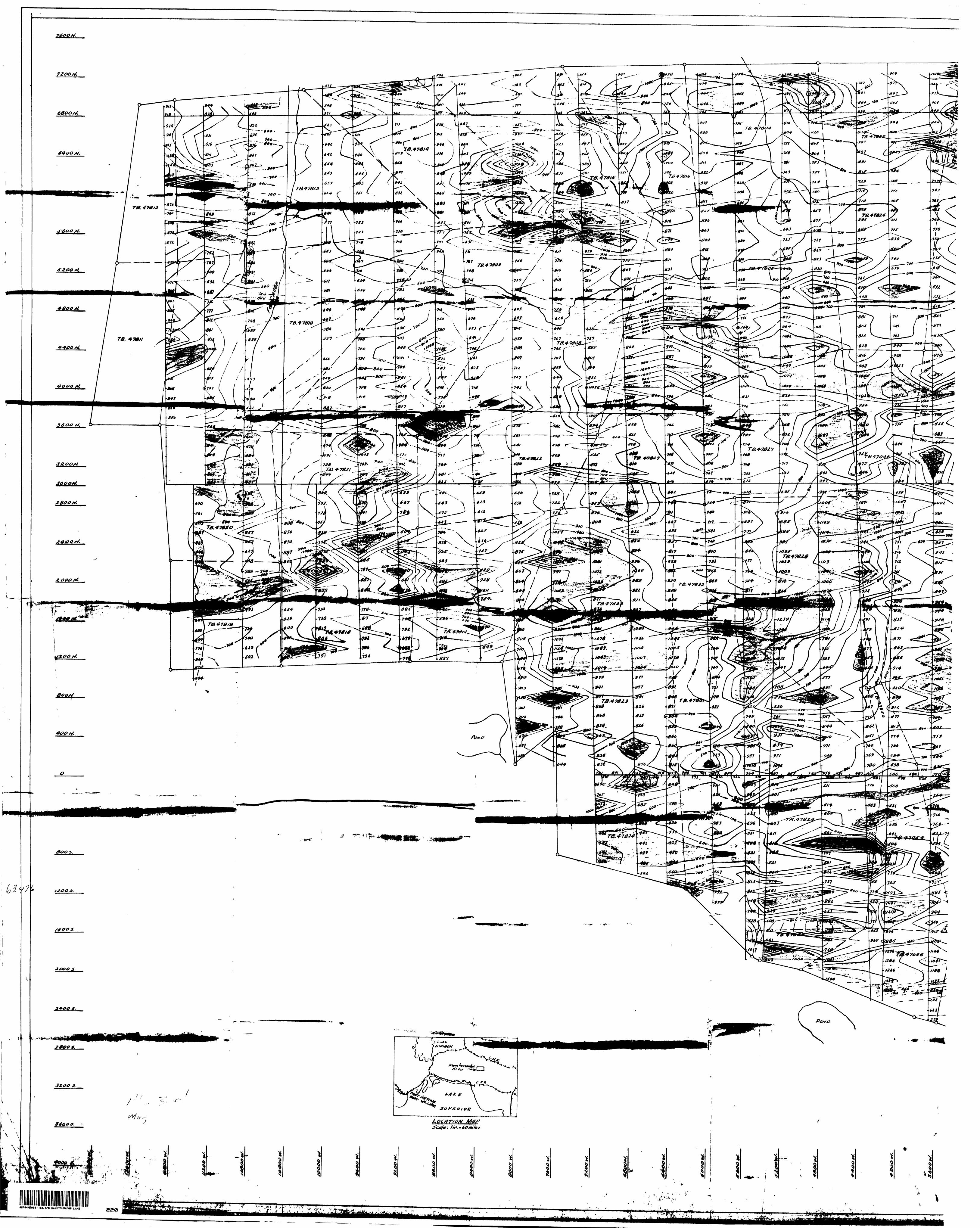
Herewith is report and plan, in duplicate, of the magnetometer survey carried out on the property of Hucarnp Minos Limited, Manitouwadge Area, Port Arthur Mining Division, as required by the Ontario Mining Act. Section 81, 5 (a).
PROPERTY: '-X iThe property consists of seventy-one mining claims numbered TB 470XkO
to /..7076 inclusive, TD 47583 to 47586 inclusive, TB 47804 to 47833 inclusive, in the vicinity of Wowun Lake, Manitouwadge Area, District of Thunder Bay.
KKASON FOR .S
Huca'np Mines property adjoins the Goco Mines property on the east and northeast and a Magnetometer survey was carried out to outline the eastward extension of the sedimentary formations at Geco, in. rfhich the orebody is contained and to determine if other favourable structures exist.
KiiftULTS OF SUHVEY :
(a) The principal result is the outlining, in detail, of the continua tion of the Gc co zone. This strikes N 60O E. across the property starting just north of the pond on the southwest boundary. The change in strike of the zone, from that at Goco, is apparently due to a NW-SE fault just south of the southwest boundary. lean iron formation occurring along the zone makes the zone show up quite strongly magnetically.
This 7, one, though appearing quite straight, is made up of lenses in "en echelon" formation or faulted slightly. These lenses strike east-west. Limited drilling on the zone to date has shown that in at least one case, a north- south fault has caused the offsetting of the zones.
(b) A diabase dike extends from the southeast corner of Wowun Lake to Mose Lake. (This has been confirmed by drilling at one point.) This is apparently the continuation of the north striking diabase dike seen on the south shore of Hose lake.
f
t-
Contoegt exploration Company Htmittb85 RICHMOND STREET WEST
TORONTO I. CANADA
Heron Bay, Ontario. September 27, 1954.
The Ontario Department of Mines, Port Arthur Mining Division, Port Arthur, Ontario.
Dear Sirs:63.476 MANITOUWADGE LAKE
010
Herewith is report and plan, in duplicate, of the magnetometer survey carried out on the property of Hucamp Mines Limited, Manitouwadge Area, Port Arthur Mining Division, as required by the Ontario Mining Act, Section 81, 5 (a). -* -r
PROPERTY:
The property consists of seventy-one mining claims numbered TB 47040 to 47076 inclusive, TB ^7583 to 47586 inclusive,' TB 478Q4 to. 47833.inclusive, in the vicinity of Wowun Lake, Manitouwadge Area, District of Thunder Bay.
REASON FOR SURVEY;
Hucamp Mines property adjoins the Geco Mines property on the east and northeast and a magnetometer survey was carried out to outline the eastward extension of the sedimentary formations at Geco, in which the orebody is contained and to determine if other favourable structures exist.
RESULTS OF SURVEY:
(a) The principal result is the outlining, in detail, of the continua tion of the Geco zone. This strikes N 600 E. across the property starting just north of the pond on the southwest boundary. The change in strike of the zone, from that at Geco, is apparently due to a NW-SE fault just south of the southwest boundary. Lean iron formation occurring along the zone makes the zone show up quite strongly magnetically.
This zone, though appearing quite straight, is made up of lenses in "en echelon" formation or faulted slightly. These lenses strike east-west, limited drilling on the zone to date has shown that in at least one case, a north- south fault has caused the offsetting of the zones.
(b) A diabase dike extends from the southeast corner of Wowun Lake to Mose Lake. (This has been confirmed by drilling at one point.) This is apparently the continuation of the north striking diabase dike seen on the south shore of Mose Lake.
Contort exploration Company limited85 RICHMOND STREET WEST
TORONTO 1. CANADA
- 2 -
(c) A NW-SE fault cuts through the main zone just west of Wowun Lake with only small horizontal displacement.
(d) In the southeast portion of the property, a number of minor anomalies occur due to the presence of granite gneiss and paragneiss beds in the granite.
(e) In the north central portion of the property, anomalies are caused by gneiss and a limited amount of iron formation.
DATA ON SUftVEY:
Survey carried out by Conwest Exploration Co, for Hucamp Mines Ltd.
FIELD WORK:
Linecutting - January 14 - March 24* 1954 Chief line cut ter - 0. J. Gastpisi^r Total man days linecutting -/3103 Miles of linecut - 71.4 Magnetometer survey - February 14- - May 17, 1954
and June 17 - June 25, 1954 Chief operator - D, J. Kemp- .-. Total man days in survey ~\2 Number of stations established - 3492
INSTRUMENTS USED:
Watt vertical magnetometer (#75151); sensitivity 26.1 gammas per scale division
Watt vertical magnetometer (#43550)j sensitivity 29.1 gammas per scale division.
CONSULTANT: L. K. Lytle •i
Total man days work - 558
Work allowance s 558 x 4 rr 2232 days work s 31.4 days per claim.
Respectfully submitted,^
LKL/AS
L. W Lytle, gineer and Geologist.
iHucamp Mines Limited^ Richmond Street, West
Toronto, Ontario42F84NE0061 63.476 MANITOUWADGE LAKE OSO
Gentlemen:
The following report covers the electrical
resistivity survey conducted over your property located
in the Manitouwadge Lake area, District of Thunder Bay,
Port Arthur Mining Division, Ontario.
The survey was conducted by Geo-Technical Develop
ment Company Limited during the period from March ^th to 14th,
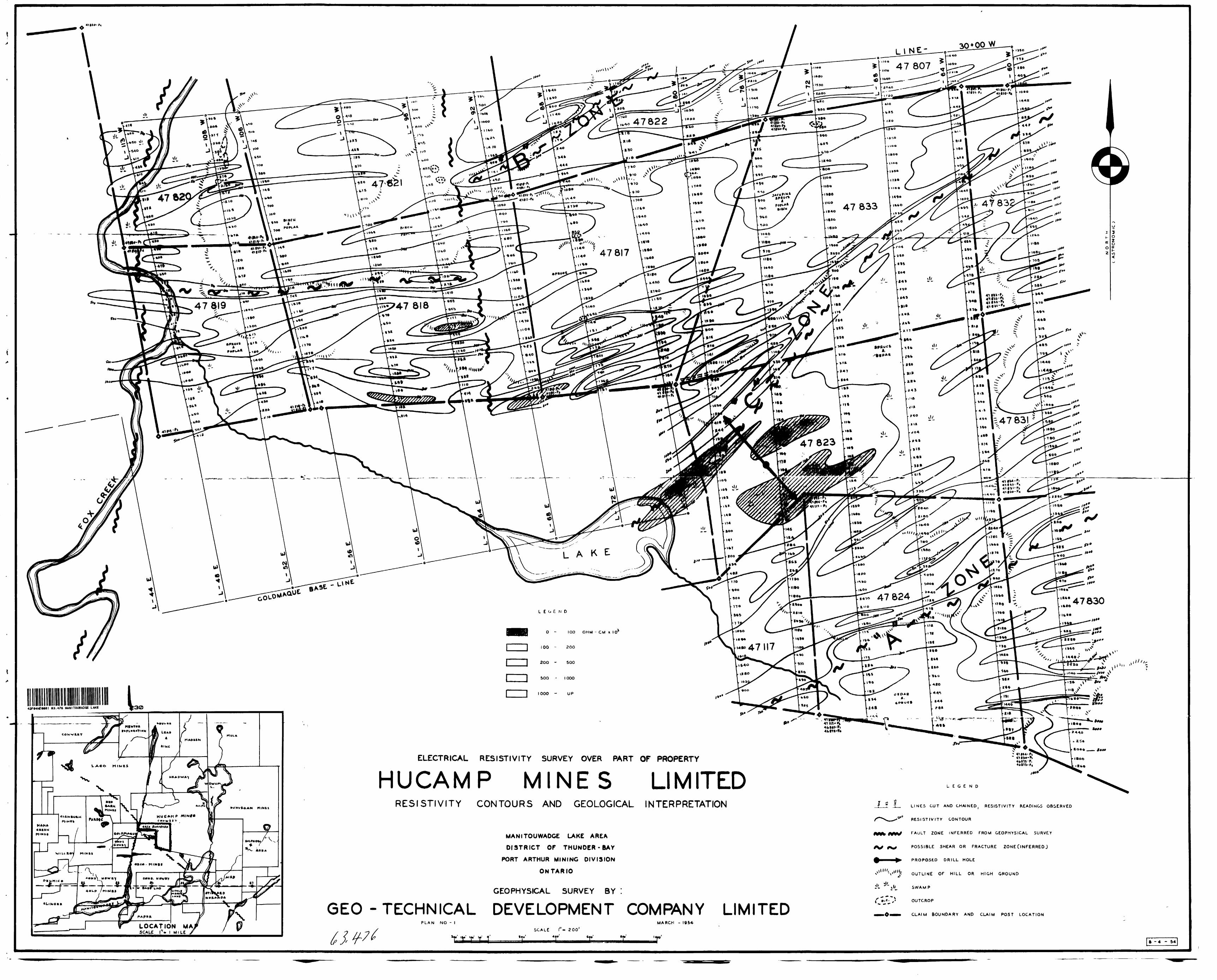
19^4- The results are shown on the accompanying Plan No. 1.
Summary and Re commendati ons
Three electrical conductors were indicated by the
survey, each crossing from the Goldmaque Mines property and
striking in a northeast direction. The area has been in
volved in a complicated shear and fault pattern.
The three conductors are of sufficient strength
and extent to warrant further investigation. Prospecting,
geological mapping and diamond drilling are recommended.
Further electrical resistivity work is also recommended to
trace the zones to Wowun Lake.
Property, Location and Access
The area covered by the survey comprises a portion
of the large group known as the Hucamp Mines Limited property,
further described as claims numbered 47817, 47818, 47819, 47820,*
47821, 47822, 47823, 47821}, 47830, 47831, 47832, 47833, 47807.
Of these, 47820/21/22/07/30/31/32 are half-ciaims, as shown on
Plan No. 1. The claims group adjoins the property of Goldmaque
Mines Limited on the southwest and Geco Mines Ltd on the south.
GEO - TEC H N l C A L DEVELOPMENT COMPANY LIMITED
- 2 -
The property can be reached by a tractor road
and trail which runs north from Lake Manitouwadge, approxi
mately one mile to the property, and which follows Pox
Creek from its junction with the lake. Manitouwadge Lake
can also be reached by air from Geraldton or Marathon,
from various helicopter bases at Stevens or Camp 12, and
by winter snowmobile road from a camp of the Ontario Pulp
fc Paper Company to the south, which is reached by truck
road from Hemlo on the C.F.R. A trail leads from the
Goldmaque Mines property across the Hucamp Mines property
to Wowun Lake which lies in the east portion of the claims
gr oup.
The area surveyed is fairly rugged and heavily
forested with spruce, Jackpine, birch and poplar. A swamp
which is covered with cedars occupies the central part of
the property.
General Geology
The geology of the general area is described in
the Ontario Department of Mines Vol. XLI, Part VI, 1932,
"Geology of Huron Bay, White Lake Area", by Jas. E.
Thompson. Otherwise our information on the area is very
limited.
The property lies in granite and granite gneiss
north of the narrow greenstone belt in which the Geco Mines
Limited orebody is located. Various narrow greenstone
ribbons appear to strike east towards Wowun Laka. The
trends shown by the electrical resistivity survey do not
indicate a massive, uniform intrusive. Bedded or banded
BED - TEC HNICAL DEVELOPMENT COMPANY LIMITED
- 3 -
formations are indicated; gn eisses and sheared greenstone
may be expected.
Explanation of Resistivity Method
The method used by Geo-Technical Development
Company Limited is a form of the early resistivity methods
modified by some eight years' experience in the field.
In effect, a known current is put into the ground
and readings are taken at 50 foot intervals along picket
lines by sensitive vacuum tube voltmeters measuring the
voltage drop across this interval. Calculations translate
these voltage readings into resistance values in terms of
ohm-centimeters. These are plotted on the map accompany
ing this report.
Due to the inhomogeneity of the medium being
examined; i.e., the complexity of the geology and structure,
interpretations are based on experience and a knowledge of
the geological conditions in the area being tested with
this particular method. Where the latter are unknown, the
interpretation must, of necessity, be limited or very
tentative.
However, without any geological information it
is generally possible to differentiate between banded rocks
such as volcanics, sediments or gneiss and large bodies of
massive intrusive*, due to the difference of electrical con
ductivity between the various flows or beds. Strike trends,
folding, etc. are therefore readily picked up. In some
cases rock contacts may be inferred.
GEO -TECHNICAL DEVELOPMENT COMPANY LIMITED
- k -Shear or fracture zones are relatively better
conductors, due to their higher water content. Where
extreme low resistivity values are found, graphite or
sulphides are indicated. Graphite is found in schist
or shear zones or sedimentary horizons, which are shown
by electrical methods as, generally, narrow low linear
trends. Unfortunately, from the point of view of inter
pretation, sulphides may be present with the graphite or
may occur in shear zones giving similar low linears,
Interpretation of Resistivity Results
The overall electrical picture suggests gneissic
or sheared rocks striking generally northeast on the east
ern part of the claims group and more nearly east in the
northwest part; the whole area being involved in a com
plicated shear and fault pattern.
Two cross-fault directions are inferred, one
north and south, the other a few degrees east of north.
The fault which lies along Pox Creek is apparently the
same one which cuts the Geco Mines Limited orebody. In
the west part of the area minor east-west shearing is
present. In the north central and east, north-east shear
ing is present. This shearing is disclosed by the three
good conductors identified as the "A", "B" and "C" zones
on the accompanying Plan.
"A" zone lies in the southeast corner of the
claims group, trending northeast. It is not an exceptionally
G E O -TECHNICAL DEVELOPMENT COMPANY LIMITED
strong conducting zone but is well lineated, and appar
ently marks the trend of gneissic or schistose rock
formations.
"B" zone lies in the northwest portion of the
area and is a fairly strong, narrow, lineal zone of good
conductivity. It trends northeast, ending abruptly on
the west at an inferred north-south fault. This good con
ductor may represent a sheared or fractured zone. The
zone appears to have a slightly different strike from
the southern part of the surveyed area. There is a "dead"
area which extends north and south past the west end of
this zone. This "dead" area is inferred to be a north-
south fault typical of the region. There appears to be
an offset of approximately ^00 feet between the eastern
and western portions of "B". The western portion shows a
slightly different strike.
"C" zone of good conductivity is believed to
represent a sheared or fractured zone. It has a north
easterly strike, a length of 2l|00 feet, and appears to be
a continuation of a shear cone which extends northeast
from the adjoining property. Two irregular, parallel zones
lie on the south flank of "C".
"C" zone appears to be the most persistent and
well delineated zone outlined by the resistivity survey.
Two diamond drill holes have been laid out tentatively
as cross-section holes across this zone.
GEO -TECHNICAL DEVELOPMENT COMPANY LIMITED
. 6 -
Survey Data
An electrical resistivity survey was conducted
over the property of Hucamp Mines Limited located in the
Manitouwadge Lake area, District of Thunder Bay, Port
Arthur Mining Division, Ontario. The survey was con
ducted by Geo-Technical Development Company Limited
during the period from March 5th to U+th, 19^. The
results are shown on the accompanying Plan No. 1.
Electrical resistivity readings were taken
at 50 foot intervals along the north-south picket
lines. These readings are shown on Plan No. l, plotted
in ohm-centimeters x 10^.
A total of 7*32 miles of line were surveyed
by the electrical resistivity method, which required
773 station readings. The total area covered by this
survey is approximately 338 acres.
G E O -TECHNICAL DEVELOPMENT COMPANY LIMITED
- 7 -
The number of eight-hour man-days required
to complete this work is as follows:
(8-hour) Attributable to Man Days Assessment Work
Laying spread wire 2 x tj. 8
Operating Resistivity Survey 9 x Ij. 36
Calculation Se Interpretation 2 x 14. 8
Drafting 6 x !| 2lj.
Office typing and supervision If x 1| 16
TOTALS 23 \ 92
Respectfully submitted,
GEO-TECHNIOAL DEVELOPMENT COMPANY LTD.
f JE. P. Sheppard Geologist
May 19, Toronto, Ontario
GED - TECHNICAL DEVELOPMENT COMPANY LIMITED
i I
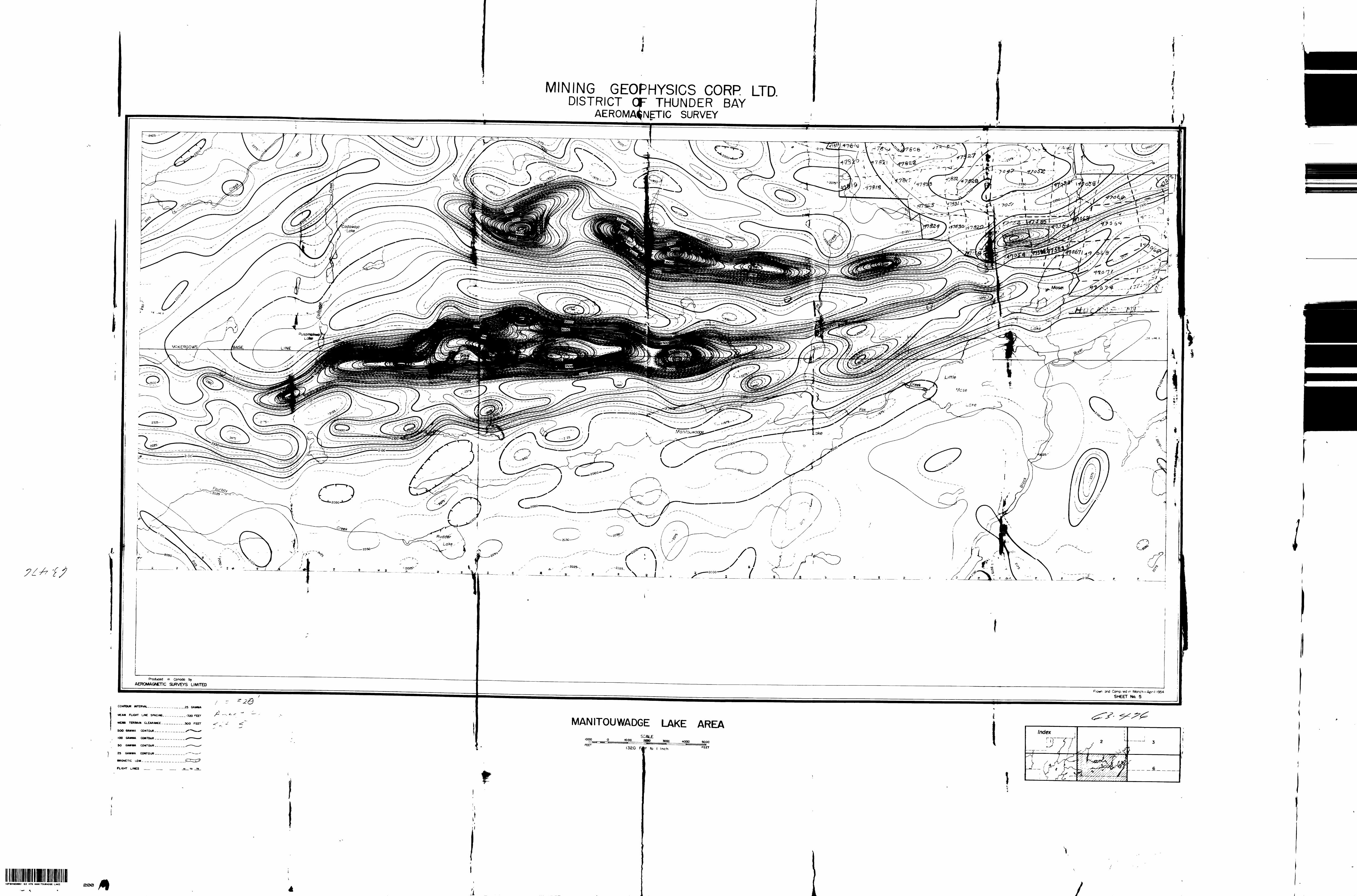
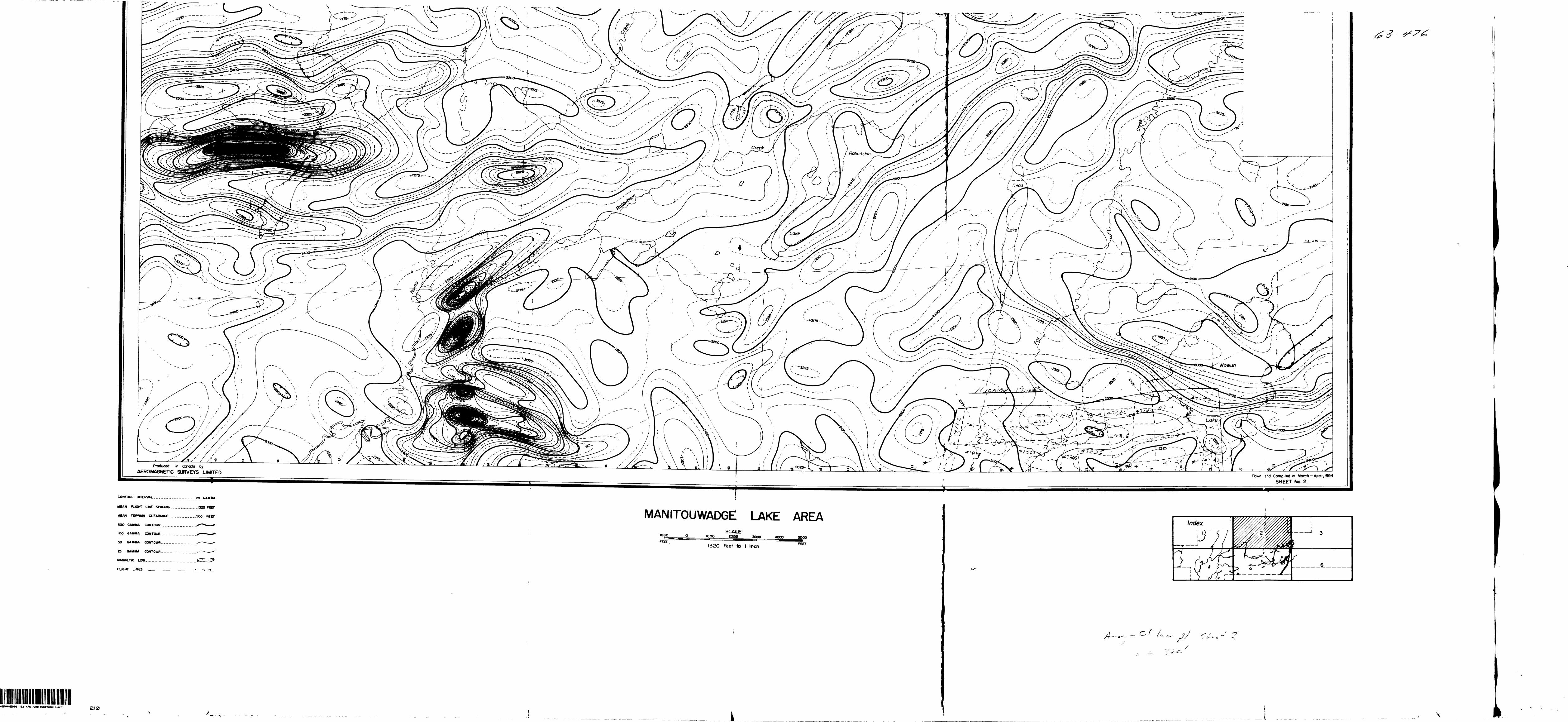
MINING GEOPHYSICS CORP LTDDISTRICT OF THUNDER BAY
AEROMAGNETIC SURVEY
produced m Canada by AEROMAGNETIC SURVEYS LIMITED
R own and Comp.iedm March- April 1954 SHEET No. 5
MCA* FUGHT UME SPACING- - . . . , . _ . I32O FEET
MEJH TBIWUdl O.EAHAWCE . . . . . . . . . .500
5OO GAMMA CONTOUR
(OD GAMMA COMTOUfl
5O GAMMA CONTOUR
25 GAMMA CONTOUR
MAGNETIC UOW
FLIGHT UNES
MANITOUWADGE LAKE AREA
30OC 4OOO
I32O FAf to l tnch
63 476 MAMITDUVAOGE LAKE
•— \
200
I
*2F*4*fM6t 63 476 MANITOUVAOGE LAKE 210
Produced m Canada by AEROMAGNETIC SURVEYS UNITED
Flown and Compiled m March — Apnl,O54 SHEET No 2
CONTOUR
MEAN FU6HT LME SPACING. - . . ... . . J3ZQ
MEAN TEfTRAM CLEARANCE . . . ,- . ,, . ,.50O fEET
5OO GAMMA CONTOUR. --..-.-.. _ .X*"**^ *
IOO GAMMA CONTOUR.
SO GAMMA CONTOUR.
25 GAMMA CONTOUR
MAGNETIC LOW--, - ,
FU6HT UNES __
MANITOUWADGE! LAKE AREA1000 ZOOO 3000 4000 5000
J32O Feet ID l Inch FEET
l
/o
i/ '\ .i/^N
\x# Jio^
T0.+70IO
' ~V,-^
r r ^. \Jf
* *^^
K 'PUT-IW V** "' :V -
63.478 MANITOUWADQE LAKE
-v^ ̂.
^tfj ^*-
r^^l\ tww
-nl. i l' L*
f, jtnOfW ^
y 3 j. 3 wo M 3N o
Q3JM-]
S. 47824
IOO OHM - CM x I01
42F*4NE**61 B3.476 MANITOUWADGE UAKE
——l-4*-,MJ-.-~.4U-40CP /MiMKS
LOCATION MASCALE l - l MILE
ELECTRICAL RESISTIVITY SURVEY OVER PART OF PROPERTY
HUCAMP MINES LI MITEDRESISTIVITY CONTOURS AND GEOLOGICAL INTERPRETATION
MANITOUWADGE LAKE AREA DISTRICT OF THUNDER-BAY
PORT ARTHUR MINING DIVISION ONTARIO
GEOPHYSICAL SURVEY BY i
GEO-TECHNICAL DEVELOPMENT COMPANY LIMITED
LEGEND
LINES CUT AND CHAINED, RESISTIVITY READINGS OBSERVED
RESISTIVITY CONTOUR
FAULT ZONE INFERRED FROM GEOPHYSICAL SURVEY
POSSIBLE SHEAR OR FRACTURE ZONE (INFERRED J
PROPOSED DRILL HOLE
OUTLINE OF HILL OR HIGH GROUND
SWAMP
OUTCROP
CLAIM BOUNDARY AND CLAIM POST LOCATION
PLAN NO - MARCH - I944-
V V 'f f 1'
SCALE l"- 200' t**'_______4p"______