Embed Size (px)
Citation preview

Document Number: RCMA‐02‐EM‐PLN‐005v0
CERVANTES 1
CONVENTIONAL
OIL EXPLORATION WELL
SECTION 38 REFERRAL
SUPPORTING DOCUMENTATION

RCMA‐02‐EM‐PLN‐005 PAGE | 2 of 62
Revision Control
0 09/07/2020 Submission of Supporting Document with
Referral to EPA ASW MJ KA
Rev Date Description By Checked Appr.
Document Number RCMA‐02‐EM‐PLN‐005
RCMA‐02‐EM‐PLN‐005 PAGE | 3 of 62
Executive Summary
The Cervantes Oil Exploration Prospect is located 11 km south of Dongara / Port Denison in the onshore Perth Basin.
RCMA is proposing to drill one conventional oil exploration well to determine if there is oil in the prospect, involving the following activities:
1. Site Preparation (disturbance of up to 5.3 ha)
2. Equipment Mobilisation
3. Drill, Case and Cement, or Decommission the Well in accordance with Well
Management Plan
4. Demobilisation
5. Site Restoration and Rehabilitation
If the well is a commercial discovery, the well would be connected by flowline to the existing nearby Jingemia Production Facility (JPF) (outside the scope of this exploration proposal).
The well has been located specifically to avoid the sensitive dunes in the Beekeeper Nature Reserve (BKNR) and utilise existing tracks to the well pad.
No hydraulic fracture stimulation (‘fraccing’) is involved in this proposal.
Summary of the Proposal
Proposal Title Cervantes 1 Conventional Oil Exploration Well
Proponent Name RCMA Australia
Short Description
The proposal includes all activities associated with drilling a conventional oil exploration well
The proposed development envelope is 36.5 ha with an area of disturbance of 5.3 ha
No hydraulic fracture stimulation
Environmental Factors Summary
With the assistance of subject matter experts, RCMA has assessed the full suite of relevant environmental factors and determined that the potential environmental impacts can be managed using established management techniques to levels that RCMA considers are not environmentally significant. Each of the key environmental factors are summarised below with reference to relevant sections providing further details.
Flora and Vegetation (Section 7.1)
The proposed development envelope clearing area is small (5.3 ha), with proposed impacts to locally mapped vegetation communities all <0.3%. A Priority Ecological Community (PEC) occurring in the proposed development envelope has been mapped locally over 681 ha and will not be significantly affected by the proposal (1.79 ha). Field reconnaissance and targeted surveys have identified that there is no significant flora within the vegetation communities of the proposed development envelope.

RCMA‐02‐EM‐PLN‐005 PAGE | 4 of 62
The suite of management measures, outlined in a Vegetation Management Plan and Hygiene Management Plan, will be implemented for this proposal to minimise impacts to flora and vegetation.
Terrestrial Fauna (Section 7.2)
The proposed development envelope is small in the context of the coastal belt and region with similarly small areas of impact proposed to the vegetation communities (habitats) present. Therefore, the impact of the proposal on the local fauna assemblage is expected to be minor and localised.
The Carnaby’s Black‐Cockatoo would be present as a regular migrant but only in small numbers, as the vegetation is of low foraging value for the species and there is no roosting or breeding habitat. The potential loss of foraging habitat for species such as the Carnaby’s Black‐Cockatoo is expected to be negligible due to the small proposed impact area, the low‐quality foraging value of the vegetation and presence of similar habitat nearby.
The suite of management measures, including a Fauna Management Plan, to be implemented for this proposal will protect fauna and fauna habitat.
Inland Waters (Section 7.3)
Drilling activities are managed in accordance with Department of Mines, Industry Regulation and Safety (DMIRS) lead regulatory requirements, which include well construction, full chemical disclosure of any chemicals used down‐hole and management of drilling wastewater. The suite of management measures to be implemented for this proposal will protect groundwater (the only inland water receptor in the proposal area).
Regulatory Assessment
Existing regulatory requirements necessitates RCMA to gain approval for all aspects of the proposal, even if a formal Environmental Protection Authority (EPA) assessment of this proposal were required. Consequently, RCMA concludes that as the environmental impacts associated with this proposal are not significant, they can be managed through best practice environmental management and assessment through established regulatory processes.

RCMA‐02‐EM‐PLN‐005 PAGE | 5 of 62
Table of Contents
Revision Control ....................................................................................................................................... 2
Executive Summary .................................................................................................................................. 3
Table of Contents ..................................................................................................................................... 5
List of Figures . ....................................................................................................................................... 6
List of Tables . ....................................................................................................................................... 6
List of Appendices .................................................................................................................................... 7
Terms & Abbreviations ............................................................................................................................. 8
1. Introduction ................................................................................................................................. 9
2. The Proponent ............................................................................................................................. 9
3. Proposal Description .................................................................................................................10
3.1 Background ............................................................................................................................... 10
3.2 Legislative Framework .............................................................................................................. 10
EP Act, Part V, Division 2 – Clearing of Native Vegetation ........................................................10
Petroleum & Geothermal Energy Resources Act 1967 .............................................................10
Environmental Protection and Biodiversity Conservation Act 1999 .........................................10
Conservation and Land Management Act 1984 ........................................................................11
4. The Proposal ..............................................................................................................................12
4.1 Proposal Justification ................................................................................................................ 12
4.2 Proposal Timing ........................................................................................................................ 12
4.3 Description ............................................................................................................................... 14
Site Preparation .........................................................................................................................14
Mobilisation / Demobilisation ...................................................................................................15
Drill and Complete / Decommission Well .................................................................................15
Site Restoration and Rehabilitation ...........................................................................................16
Water Requirements .................................................................................................................16
Proposal Schedule .....................................................................................................................16
5. Stakeholder Engagement ..........................................................................................................17
6. Environmental Principles and Factors .......................................................................................22
6.1 Principles .................................................................................................................................. 22
7. Identification of Key Environmental Factors .............................................................................24
7.1 Key Environmental Factor – Flora and Vegetation ................................................................... 25
EPA Objective ............................................................................................................................25
Legislation, Policy and Guidance ...............................................................................................25
Receiving Environment ..............................................................................................................25
Potential Impacts .......................................................................................................................40
Assessment of Impacts ..............................................................................................................40
Avoidance and Mitigation .........................................................................................................41
Predicted Outcomes ..................................................................................................................42
7.2 Key Environmental Factor – Terrestrial Fauna ......................................................................... 43
EPA Objective ............................................................................................................................43
Legislation, Policy and Guidance ...............................................................................................43

RCMA‐02‐EM‐PLN‐005 PAGE | 6 of 62
Receiving Environment ..............................................................................................................43
Potential Impacts .......................................................................................................................46
Assessment of Impacts ..............................................................................................................46
Avoidance and Mitigation .........................................................................................................48
Predicted Outcomes ..................................................................................................................48
7.3 Key Environmental Factor – Inland Waters .............................................................................. 50
EPA Objective ............................................................................................................................50
Legislation, Policy and Guidance ...............................................................................................50
Receiving Environment ..............................................................................................................50
Potential Impacts .......................................................................................................................52
Assessment of Impacts ..............................................................................................................52
Avoidance and Mitigation .........................................................................................................52
Predicted Outcomes ..................................................................................................................54
7.4 Other Environmental Factors ................................................................................................... 55
8. Significance Test ........................................................................................................................56
9. Conclusions ................................................................................................................................58
9.1 Overview ................................................................................................................................... 58
9.2 Flora and Vegetation ................................................................................................................ 58
9.3 Terrestrial Fauna ....................................................................................................................... 58
9.4 Inland Waters ........................................................................................................................... 58
10. References .................................................................................................................................59
List of Figures .
Figure 1: Proposed Development Envelope 13
Figure 2: Desktop Area / Proposed Development Envelope 26
Figure 3: Vegetation Type Mapping ‐ North West 34
Figure 4: Vegetation Type Mapping ‐ North East 35
Figure 5: Vegetation Type Mapping ‐ Central 36
Figure 6: Vegetation Type Mapping ‐ Southern 37
Figure 7: Vegetation Type W1 Mapped Widely as part of Denison 3D Project 39
List of Tables .
Table 1: Proposal Disturbance 12
Table 2: Cervantes 1 Proposal Cadastre 12
Table 3: Indicative Proposal Schedule 16
Table 4: Consultation Record 18
Table 5: Principles considered for the Proposal 22
Table 6: Key Environmental Factors Relevance to the Proposal 24
Table 7: Baseline Field Surveys – Flora and Vegetation 25
Table 8: Vegetation System Associations within Proposed Development Envelope 27
Table 9: Significant Vegetation Returned from DBCA Database Searches 27
RCMA‐02‐EM‐PLN‐005 PAGE | 7 of 62
Table 10: Significant Flora Taxa Known from Within the Desktop Study Area 28
Table 11: Proposed Project Disturbance – Vegetation Communities 29
Table 12: Introduced Taxa Known from Within the Desktop Study Area 29
Table 13: Proposed Development Envelope Vegetation Communities 38
Table 14: Vegetation Systems Disturbance 40
Table 15: Proposed Vegetation Communities Disturbance 41
Table 16: Composition of vertebrate fauna assemblage 43
Table 17: Conservation Significant Fauna Species Expected to Occur 44
Table 18: Hydrogeological Setting 50
Table 19: Other Environmental Factors and Proposed Management 55
Table 20: Significance Criteria Assessment 56
List of Appendices
................................................................................................................... Proposal Area
........................................................................................................... Petroleum Permits
.............................................................................................. Environmental Sensitivities
........................................................................................................................... Cadastre
................ Reconnaissance and Targeted Flora and Level 1 Fauna Survey (March 2020)

RCMA‐02‐EM‐PLN‐005 PAGE | 8 of 62
Terms & Abbreviations
Abbreviation / Term Descriptor
ALARP As low as reasonably practicable
BKNR Beekeepers Nature Reserve
BoM Bureau of Meteorology
CO2‐e Carbon Dioxide equivalent
DBCA Department of Biodiversity, Conservation and Attractions
DMIRS Department of Mines, Industry Regulation and Safety
DoEE Department of Environment and Energy
DWER Department of Water and Environmental Regulation
EIA Environmental Impact Assessment
EP Environmental Plan
EPA Environmental Protection Authority
EP Act Environmental Protection Act 1986
EPBC Act Environment Protection and Biodiversity Conservation Act 1999
ESA Environmentally Sensitive Area
GDE Groundwater Dependent Ecosystem
IDE Inflow Dependent Ecosystem
JPF Jingemia Production Facilities
km Kilometre
MNES Matter of National Environmental Significance
NVCP Native Vegetation Clearing Permit
OSCP Oil Spill Contingency Plan
PDWSA Public Drinking Water Source Protection Area
PGER Act Petroleum and Geothermal Energy Resources Act 1967
RCMA RCMA Australia Pty Ltd
SDS Safety Data Sheet
TDS Total dissolved solids
WA Western Australia
WoNS Weeds of National Significance

RCMA‐02‐EM‐PLN‐005 PAGE | 9 of 62
1. Introduction
This document has been prepared to provide supporting information for the referral of RCMA’s conventional drilling proposal, Cervantes 1, within Production Licence L14, south of Dongara, Western Australia (Appendix A) under Section 38 of the Environmental Protection Act 1986. This document describes the proposal, potential environmental impacts and risks and proposed mitigation measures associated with all phases of the proposal.
This document has been prepared in accordance with Environmental Impact Assessment (Part IV Divisions 1 and 2) Administrative Procedures 2016.
2. The Proponent
This proposal is within Petroleum Production Licence L14 (Appendix B). The Permit is wholly owned by RCMA Australia.
RCMA is a part of Jade Energy, a privately owned Singapore energy trading and retail company with over 100,000 electricity customers. RCMA is an Australian upstream oil and gas company that has since 2016 been seeking investment opportunities in mature oil and gas production properties and oil and gas exploration.
The company is actively exploring the L14 licence area by reprocessing and reinterpreting past 3D and 2D seismic with the intention to drill exploration wells.
RCMA own and operate the Jingemia Production Facility (JPF), an onshore Perth Basin oil production facility situated in Petroleum Production Licence L14,3 km from the Cervantes 1 Conventional Oil Exploration Drill Site. A Cervantes 1 Development would utilise the existing JPF Facilities.

RCMA‐02‐EM‐PLN‐005 PAGE | 10 of 62
3. Proposal Description
3.1 Background
RCMA propose to drill the Cervantes 1 Conventional Exploration Oil Well 11 km south of Dongara/Port Denison within Production Licence L14. The proposed site is located within the BKNR in the northern Perth Basin (Appendix C). The proposed conventional exploration well has been deviated to avoid environmental sensitivities and will be drilled to a planned depth of 2562 mTVDss (true vertical depth). The well has been located specifically to avoid the sensitive dunes in the BKNR and minimise clearing by utilising existing tracks to the well pad. The additional cleared area for the proposal is 5.3 ha within a development envelope of 36.5 ha with 4.5 km of existing road and tracks utilised for access. Site preparation operations are planned to commence in quarter 1 2021 for drilling operations commencing in late quarter 1 2021, subject to availability of a suitable drilling rig.
3.2 Legislative Framework
This proposal is referred to the Environmental Protection Authority (EPA) under Section 38 of the Environmental Protection Act 1986 (EP Act) to determine whether the proposal requires formal environmental impact assessment (EIA). In accordance with the Memorandum of Understanding with the EPA and DMIRS, DMIRS is the lead agency for assessing petroleum activity proposals, including environmental regulation of proposals that do not trigger formal EIA. RCMA has reviewed the EPA’s Statement of Environmental Principles, Factors and Objectives as part of the EPA’s framework for environmental considerations in EIA. This environmental referral document demonstrates that potential impacts of the proposal are not significant and can be managed within the DMIRS and other environmental regulation frameworks listed below.
EP Act, Part V, Division 2 – Clearing of Native Vegetation
A Native Vegetation Clearing Permit (NVCP) is required under the EP Act prior to clearing native vegetation. Granting and administration of clearing permits is regulated under Part IV Division 3 of the EP Act managed under the Environmental Protection (Clearing of Native Vegetation) Regulations 2004.
DMIRS regulate clearing permits in the petroleum industry and will regulate the requirement and management of clearing permits for this proposal.
Petroleum & Geothermal Energy Resources Act 1967
Under the Petroleum and Geothermal Energy Resources (PGER) (Environment) Regulations 2012 an Environment Plan (EP) must be accepted by DMIRS for petroleum related activities (including decommissioning and rehabilitation) before such activities can commence. The EP must evaluate all impacts and risks that are associated with an activity, and demonstrate that with the control measures identified, the impacts and risks are reduced to levels that are ALARP. Further to this, the EP must demonstrate that the environmental impacts and risks are acceptable. Included with an EP is an Oil Spill Contingency Plan (OSCP) which covers all spill scenarios associated with the activity.
Environmental Protection and Biodiversity Conservation Act 1999
A proposal may be deemed a ‘Controlled Action’ under the Environment Protection and Biodiversity Conservation Act 1999 (EPBC Act) if it impacts on Matters of National

RCMA‐02‐EM‐PLN‐005 PAGE | 11 of 62
Environmental Significance (MNES). No significant impacts on MNES have been identified for this proposal and it has not been referred to the Commonwealth Department of Environment and Energy (DoEE) under the EPBC Act. This includes advice RCMA has received on potential impacts to Carnaby’s Black Cockatoo foraging habitat.
Conservation and Land Management Act 1984
The Conservation and Land Management Act 1984 promotes the conservation, protection and management of land and waters, including flora and fauna in conservation estate areas as listed by the Department of Biodiversity, Conservation and Attractions (DBCA). This act outlines restrictions in relation to entry and conduct in conservation estate land without lawful authority. The proposed Cervantes 1 Conventional Oil Exploration Well location is within the BKNR. Under Section 15A of the Petroleum Act 1967, the proposal will be referred to DBCA for their assessment and if approved, signed off by the Minister for Environment.

RCMA‐02‐EM‐PLN‐005 PAGE | 12 of 62
4. The Proposal
RCMA propose to construct the Cervantes 1 Conventional Oil Exploration Well within Production Licence L14 in the Shire of Irwin south of Dongara (Appendix A).
The proposal is predominantly within the BKNR and will involve the disturbance of 5.3 ha (Table 1) within the proposed development envelope of 36.5 ha (Figure 1). Access to the site is via existing widened access tracks.
Table 1: Proposal Disturbance
Aspect Proposal Area Previously Disturbed Vegetation Clearing
Wellpad 2.6 ha 0 ha 2.6 ha
Access Track 5.1 ha 2.4 ha 2.7 ha
TOTAL 7.7 ha 2.4 ha 5.3 ha
The proposal is located on the cadastral areas indicated in Table 2 and Appendix D.
Table 2: Cervantes 1 Proposal Cadastre
Location Tenure Reserve Victoria Location
Parcel
Wellpad & Access Track
Nature Reserve 24496 12174 P039607
JPF Access Track Unallocated Crown Land ‐ 12751 P037432
Access Track Railway Reserve 24496 12810 P039607
Alternate Access Track Railway Reserve 36946 11434 ‐
4.1 Proposal Justification
The proposal is necessary to drill (by conventional drilling techniques) an oil prospect identified via seismic survey and validated by appraisal, development and producing wells drilled in the surrounding region. The primary objective of the proposal is to verify the prospect and refine the detail of the Cervantes Reservoir Structure.
The subsurface target location is close to shore however the target will be directionally drilled with the surface location chosen to be as far away from the shoreline to as possible to minimise impact on dunal landform and minimise clearing of vegetation. The chosen surface location reduces the length of access track required in comparison with the vertical location and if there were a discovery, all oil could be piped to the JPF (3km away).
4.2 Proposal Timing
The proposal is planned to commence quarter 1, 2021. Mobilisation, site preparation, drilling and demobilisation are estimated to take approximately 60 to 90 days with an additional 20 days for site restoration.

RCMA‐02‐EM‐PLN‐005 PAGE | 13 of 62
Figure 1: Proposed Development Envelope

RCMA‐02‐EM‐PLN‐005 PAGE | 14 of 62
4.3 Description
The Cervantes 1 Oil Exploration Well Drilling Proposal involves five key stages:
1. Site Preparation
2. Equipment Mobilisation
3. Drill, Case and Cement, or Decommission the Well in accordance with Well
Management Plan
4. Demobilisation
5. Site Restoration and Rehabilitation
These stages are described below.
Site Preparation
A hygiene station will be established as per the Hygiene Management Protocol.
Access Tracks
Access to the drill site will be from Brand Highway via JPF and will require the widening of existing access tracks. The tracks requiring widening, running from JPF to the Cervantes 1 Drill Site will be utilised to minimise vegetation clearing.
All equipment and materials will be mobilised via these access tracks to the well location.
Sheeting material will be sourced from an established limestone marl borrow pit approximately 15km east of the location.
Preparation of a Wellpad
The drill site will include the following elements:
Levelling, sheeting and preparation of surfaces to support compressive loads and limit erosion to the existing landscape
Conductor drilling
Construction of:
o Cellar for drilling rig
o Flare pit
o Residual drilling fluid and cuttings lined storage pond
o Water holding pond (turkey nest)
o VSP pit
Baseline monitoring (soil and groundwater)
Workshop area and office space
Smoko shack
Gen set and pump skid unit
Toilet block and sewage holding tank
Parking for light vehicles, trucks and trailers
Bunded fuel and chemical storage areas

RCMA‐02‐EM‐PLN‐005 PAGE | 15 of 62
The overall well pad will be approximately 160m x 160m in area. This includes the drill site that will be compacted along with an external area to cater for soil and vegetation stockpiling and a fire break around the perimeter. The well pad occupies an area of ~2.6 ha.
Disturbance Methods
The well has been located specifically to avoid the sensitive dunes in the BKNR and will minimise clearing by utilising existing tracks to the well pad. A maximum of 5.3 ha of native vegetation will be cleared as a result of the proposal. Vegetation clearing will be minimised as far as practicable.
Native vegetation will be cleared and stockpiled in low (<2 m windrows) to the side of the location. The topsoil will subsequently be scraped from the cleared area and stockpiled in low profile mounds away from natural drainage and the location levelled off as required by the Drilling Contractor. The stockpiled topsoil and vegetation will be reused during rehabilitation of the well location on completion of operations.
Mobilisation / Demobilisation
The drilling rig, ancillary services, personnel and supplies will be mobilised by road to the Cervantes project site. Access is via the JPF utilising the Brand Highway.
During mobilisation of the drill rig and associated services to site and during demobilisation at the end of the programme there will be approximately 70‐80 trailer loads moved.
Vehicles and equipment movement will be restricted to the designated access tracks.
A crew change bus will be used to move personnel between Perth and site for rotational crew changes and between the main offsite accommodation and site for shift changes.
Utilisation of shared vehicles and a crew change bus will minimise vehicle movement to and from the site as much as practicable, minimising local traffic and vehicle‐related safety and environment risks.
Drill, Case and Cement, or Decommission the Well
Once the drill rig is assembled on location, all activities associated with drilling (e.g. refuelling, batching of drilling water based muds (WBM) and cement) occur on the well pad.
The Cervantes 1 Proposal involves the following key stages:
Drilling the well with a rotary drilling rig using recirculated WBM (primarily (>97%) water and non‐toxic additives; barite, potassium chloride, calcium carbonate, sodium chloride and bentonite)
Conducting wireline logging evaluation of the formations drilled
Cementing well steel casing strings in place.
Rotary drilling is the process of utilising a drill string and drill bit to break small pieces of rock and remove these pieces of rock from the hole by circulating WBM down the drill string and up the annulus between the drill string and drilled hole. A blow out preventer (BOP) is installed once drilling is at a depth where it is possible for hydrocarbons to be intersected. This BOP (secondary well control) provides a mechanical means by which the well can be closed and secure the contents of the well should the WBM system fail to maintain a positive pressure on the drilled hole. If hydrocarbons are intersected, and flow

RCMA‐02‐EM‐PLN‐005 PAGE | 16 of 62
to surface is not prevented by the WBM, the BOP will be closed allowing a controlled release of these hydrocarbons to the flare pit. The flare pit and any firebreaks are constructed in compliance with any specific DFES permit requirements.
All drilling fluids will be contained within the WBM system. This system is constantly monitored by personnel and pit level sensors for volume changes.
Site Restoration and Rehabilitation
Progressive decommissioning is undertaken in accordance with the Rehabilitation Plan and involves the following activities:
Erection of abandonment plaque
Removal of any remaining ancillary equipment
Removal of wellhead and cellar
Decommission Turkey’s Nest and flare pit and fencing
Decommission mud sump and fencing
Decommissioning of the water bore
Rehabilitate drilling pad and access tracks
Monitoring is to be undertaken annually until set quantitative completion criteria are achieved as outlined in the Regulator approved Rehabilitation Plan.
Water Requirements
Groundwater will be used for WBM and cement mixing along with some fresh water trucked to site. The turkey nest / water storage pond will be used to hold a stock of water during drilling operations for mixing of WBM in the rig mud tanks.
Wastewater will be held in holding tanks prior to removal from site by a controlled waste contractor.
Proposal Schedule
The drilling is currently planned to commence in quarter 1, 2021 and will have a duration of approximately 60 to 90 days including site civil works and demobilisation (Table 3).
Table 3: Indicative Proposal Schedule
Activities Approximate Duration Indicative Timing
Site Preparation ~30 days Early Quarter 1 2021
Mobilisation ~10 days Mid Quarter 1 2021
Drilling 22‐40 days Mid to Late Quarter 1 2021
Demobilisation ~10 days Early Quarter 2 2021
The timeframe and schedules for subsequent phases (well completion, well intervention, well testing, development, care & maintenance, decommissioning, rehabilitation) will be determined based on drilling results.

RCMA‐02‐EM‐PLN‐005 PAGE | 17 of 62
5. Stakeholder Engagement
RCMA has consulted with key stakeholders in relation to its Cervantes 1 Conventional Oil Exploration Activities. The stakeholder groups have and will include:
DMIRS
EPA
DBCA
Shire of Irwin
ARC Infrastructure
Landowners
Neighbouring Hydrocarbon Facility Owners
Southern Yamatji
Table 4 summarises the key consultation events, topics raised and responses
RCMA will continue to engage with stakeholders for the life of the Cervantes 1 Proposal.

RCMA‐02‐EM‐PLN‐005 PAGE | 18 of 62
Table 4: Consultation Record
Stakeholder Date Type of Consultation People Involved Summary of Discussions Outcomes of Consultation
DMIRS Environment 14/10/2019 Meeting Ken Aitken (RCMA) Stan Bowes (DMIRS) Jacqui Middleton (DMIRS) Rohan Kok (DMIRS) Chris Newport (RCMA)
Cervantes 1 Proposal MEL to Meet with EPA MEL to Appoint Environmental Professional MEL to prepare Env applications with DMIRS/EPA in parallel MEL to plan a cross functional planning meeting with all regulatory departments present in early November.
DMIRS Environment 16/10/2019 Email Ken Aitken (RCMA) Stan Bowes (DMIRS) Jacqui Middleton (DMIRS) Rohan Kok (DMIRS) David Maher (Jade) Aveline Chan (RCMA) Chris Newport (RCMA)
Follow up to DMIRS Environment Meeting on Cervantes 1 Proposal Documentation of Actions from Meeting:
Meet with EPA within next 5‐7 working days
Appoint Environmental Professional before end of October
Proceed preparing environmental applications with DMIRS/EPA in parallel on appointing environment professional
Plan a cross functional planning meeting with all regulatory departments present in early November
DMIRS Environment 17/12/2019 Meeting Ken Aitken (RCMA) Stan Bowes (DMIRS) Jacqui Middleton (DMIRS) Rohan Kok (DMIRS) Andrea Wills (RCMA)
Cervantes 1 Proposal Update
Drilling surface location envelope identified
Surveys underway
Referral being drafted
EP being compiled
EP and OSCP to be submitted with referral end of January 2020
DMIRS Environment 20/02/2020 Meeting Ken Aitken (RCMA) Stan Bowes (DMIRS) Jacqui Middleton (DMIRS) Rohan Kok (DMIRS) Andrea Wills (RCMA) Chris Newport (RCMA)
Cervantes 1 Proposal Update
Cervantes 1 Referral Update
EP and OSCP update,
Metgasco have an office in West Perth
Consensus for RCMA to submit EP and OSCP once supporting documentation has gone to DBCA
EPA 23/10/2019 Email Helen Butterworth (EPA) Chris Newport (RCMA)
Confirmation of meeting on 28/10/2019 Request to complete “1.1 Pre‐Referral EPA Factors Objectives Table” prior to meeting
EPA 28/10/2019 Meeting Helen Butterworth (EPA) Robert Hughes (EPA) Chris Newport (RCMA) Ken Aitken (RCMA)
Briefing on proponents and Cervantes 1 Proposal MEL to conduct flora and vegetation survey MEL to refer Proposal
EPA 16/12/2019 Email Helen Butterworth (EPA) Ken Aitken (RCMA)
Request for an update meeting Meeting organised for the 23/12/2019 and the Pre‐referral EPA Factors Objectives Table submitted to EPA 18/12/2019
EPA 23/12/2019 Meeting Helen Butterworth (EPA) Robert Hughes (EPA) Ken Aitken (RCMA) Andrea Wills (RCMA)
MEL updated EPA on Cervantes 1 Proposal progress. Outcomes included:
Robert offered to provide names / links of relevant offset policies possibly relevant to track clearing
EPA also suggested highlighting reference to “conventional” and “this proposal is not fraccing” in the referral documentation
EPA suggested that the Woodman report be submitted for EPA technical review ahead of a January meeting pre‐referral submission to ensure the submission was acceptable on first submission
EPA 10/02/2020 Email Helen Butterworth (EPA) Andrea Wills (RCMA)
Submission of Desktop Flora Fauna Report Confirmation of receipt email.
EPA 13/02/2020 Phone Email
Helen Butterworth (EPA) Andrea Wills (RCMA)
Advice from EPA on adequacy of Desktop Flora Fauna Report for referral submission
EPA advise MEL to conduct their on ground surveys in accordance with EPA guidance and submit to EPA for technical assessment prior to submission of the Cervantes 1 Referral
EPA 03/04/2020 Email Helen Butterworth (EPA) Andrea Wills (RCMA)
Submission of Field Flora Fauna Report Confirmation of receipt email.
EPA 30/04/2020 Phone and Email Skye Tuffin (EPA) Andrea Wills (RCMA)
Submission of memo clarifying areas of impact Confirmation of receipt email.
EPA 15/05/2020 Phone and Email Skye Tuffin (EPA) Andrea Wills (RCMA)
Letter from Robert Hughes (EPA) in response to submission of field Flora and Fauna report.
RCMA to prepare a response and organise a meeting

RCMA‐02‐EM‐PLN‐005 PAGE | 19 of 62
Stakeholder Date Type of Consultation People Involved Summary of Discussions Outcomes of Consultation
EPA 26/05/2020 Phone Skye Tuffin (EPA) Andrea Wills (RCMA)
Request for a meeting to discuss EPA feedback on RCMA field Flora and Fauna report as there appears to be a misinterpretation of the vegetation part of the report for example the feedback states that community and condition mapping is required however there is community and condition mapping in Appendix K and N. The feedback also reports a significant reliance on the Denison data and requirements for surveying above and beyond the requirements of the EPA Guideline. The fauna specialist is working to respond to all concerns raised with no major issues on the feedback.
ST agreed to organise a “Microsoft TEAMS”meeting with the relevant EPA personnel. AW to email a list of RCMA attendees
EPA 03/06/2020 Meeting Skye Tuffin (EPA) Helen Butterworth (EPA Kelly Freeman (DWER) Ken Aitken (RCMA) Andrea Wills (RCMA) Greg Woodman (WEC)
Meeting to discuss flora and vegetation aspects of EPA feedback on RCMA Flora and Fauna report. Apologies submitted by Wendy Hudleston (DWER) who was the DWER/EPA person who had reviewed the report. Without Wendy at the meeting it was difficult to have any meaningful discussion about the issues raised in her review namely the requirement for detailed survey, the requirement for Spring survey and the reliance on Denison data.
Group resolved that RCMA would forward their three main questions on the feedback and a second meeting with Wendy in attendance would be organised once she had reviewed the questions.
EPA 09/06/2020 Phone Message & Email Skye Tuffin (EPA) Andrea Wills (RCMA)
Enquiry into status of second meeting Advice that there will be no meeting before 15/06/2020
EPA 10/06/2020 Phone & Email Helen Butterworth (EPA) Ken Aitken (RCMA)
Delay in meeting timing Follow up email from HB advising that Kelly Freeman and Wendy Hudleston are reviewing and drafting a response to RCMA’s three questions provided immediately following the first meeting. Once they have a response the EPA will contact RCMA to discuss
EPA 17/06/2020 Phone & Email Skye Tuffin (EPA) Andrea Wills (RCMA)
Advice from EPA that a Spring survey is required to confirm the findings of the February survey
RCMA responded with proposed scope of Spring survey
EPA 23/06/2020 Email & Phone Robert Hughes (EPA) Andrea Wills (RCMA)
Request for meeting to discuss scope of Spring survey
EPA 24/06/2020 Meeting Robert Hughes (EPA) Helen Butterworth (EPA) Skye Tuffin (EPA) Andrea Wills (RCMA) Ken Aitken (RCMA)
Discussion on level of survey required to confirm the findings of the February survey
RCMA to liaise with Greg Woodman on another scope and present to EPA
EPA 29/06/2020 Email & Phone Andrea Wills (RCMA) Skye Tuffin (EPA)
RCMA provided scope for Spring survey EPA phoned and provided email affirming that the scope was endorsed by EPA
Shire of Irwin 31/01/2020 Phone Andrea Wills (RCMA) Reception (SoI)
Organisation of a meeting to present the Cervantes 1 Proposal to the Shire of Irwin
Email sent with information on project to Brendan Jeans (SoI)
Shire of Irwin 27/02/2020 Phone Andrea Wills (RCMA) Brendan Jeans (SoI)
Proposed window for meeting date General discussion on oil and gas industry in Shire of Irwin including Metgasco personnel experience in Perth Basin
BJ to get back to MEL with proposed date and any additional information to be presented at meeting by MEL
Arc Infrastructure 03/12/2019 Phone Garry Bird (Arc Geraldton) Andrea Wills (RCMA)
MEL to drill adjacent to Arc Infrastructure near Dongara‐Eneabba Railway Line
Garry to forward details on to state government party responsible for consulting with industry such as Western Power etc
Arc Infrastructure 03/12/2019 Phone Karen van der Merwe (Arc) Andrea Wills (RCMA)
MEL to provide some preliminary info on activity in the aim to set up a meeting
ASW forwarded information pack via email to [email protected] on 04/12/2019
Arc Infrastructure 16/12/2019 Phone Karen van der Merwe (Arc) Andrea Wills (RCMA)
MEL information pack has not been received by Arc. ASW to resend KVDM confirmed receipt of resent information pack
Arc Infrastructure 20/12/2019 Email Jason Crowden (Arc) Andrea Wills (RCMA)
Jason suggested a meeting time after 06/01/2020 Meeting arranged for 10/01/2020
Arc Infrastructure 10/01/2020 Meeting Jason Crowden (Arc) Cameron (Arc) Ken Aitken (RCMA) Andrea Wills (RCMA)
MEL introduction of project and discussion of information required to determine constraints on railway. MEL provided approximate railway crossing coordinates
Email confirmation of outcomes:
Arc to provide MEL with the width of the railway easement and the restrictions on the use of the railway crossing.
MEL are then to provide layouts showing proposed impacts under varying scenarios (construction, development, rehab)
Arc Infrastructure 30/01/2020 Email Andrea Wills (RCMA) Follow up from meeting. No response. Follow up again 11/02/2020

RCMA‐02‐EM‐PLN‐005 PAGE | 20 of 62
Stakeholder Date Type of Consultation People Involved Summary of Discussions Outcomes of Consultation
Jason Crowden (Arc)
Arc Infrastructure 27/02/2020 Email Jason Crowden (Arc) Andrea Wills (RCMA)
Arc provided width of railway easement and advised that the crossing is a private crossing.
Arc to provide further details on the private crossing. MEL to provide project layouts to Arc.
Arc Infrastructure 15/04/2020 Email Jason Crowden (Arc) Andrea Wills (RCMA)
MEL provided layouts covering project scenarios from site preparation through to rehabilitation
Meeting to follow
Arc Infrastructure 02/06/2020 Meeting Jason Crowden (Arc) Ken Aitken (RCMA) Andrea Wills (RCMA)
Discussion on Arc internal questions on RCMA’s proposal Arc to send through queries for RCMA to respond to. Arc approval anticipated in 4 weeks.
Arc Infrastructure 15/06/2020 Phone Jason Crowden (Arc) Andrea Wills (RCMA)
Enquiry as to status of Arc internal queries to be sent through to RCMA
Queries still being compiled and will be sent through once final submission has been provided to JC
DBCA 06/01/2020 Phone Murray Baker (DBCA) Andrea Wills (RCMA)
Andrea briefed Murray on the Cervantes 1 Proposal to provide enough information for a meeting with appropriate DBCA personnel.
Murray is to get back to Andrea with possible meeting times. Andrea is to prepare material on:
Who is Metgasco / RCMA?
Proposal background including access routes
Management measures to be implemented
DBCA 15/01/2020 Meeting Murray Baker (DBCA) Cass Gray (DBCA) Alanna Channa (DBCA)(phone) Ken Aitken (RCMA) Andrea Wills (RCMA)
Briefing on Cervantes 1 Proposal RCMA to determine portion of access track in reserve vs railway easement RCMA to submit management strategies / management plans to DBCA prior to 15A referral:
Fire
Vegetation
Hygiene (Weed & Dieback)
Fauna
Access & Communications Protocol
DBCA 04/02/2020 Phone Murray Baker (DBCA) Andrea Wills (RCMA)
DBCA Jurien Bay Feedback on Cervantes 1 Proposal:
There is a known PEC in that area (as was discussed in the meeting)
What is the fate of the marl on completion of the project? MEL anticipate removal for Wellpad however access tracks are dependent on DBCA desired long‐term track requirements
What fill type will MEL be using? Limestone Marl
DBCA to follow up:
DBCA marl testing / interpretation requirements
Feedback MEL comms to Jurien Bay
DBCA 06/02/2020 Phone Murray Baker (DBCA) Andrea Wills (RCMA)
DBCA follow up from previous conversation:
At this stage MEL proposal for Marl is adequate and should be documented in their Hygiene Management Plan
DBCA will need to consider decommissioning requirements
MEL to put together a proposal on decommissioning for DBCA to comment and amend.
DBCA 30/04/2020 Email Murray Baker (DBCA) Andrea Wills (RCMA)
RCMA provided DBCA with supporting documents for DBCA review and endorsement
Confirmation of receipt email provided
DBCA 01/05/2020 Email Cassyanna Gray (DBCA) Andrea Wills (RCMA)
DBCA request for Description of Activities Section 1 and 2 of the Cervantes 1 EP provided to DBCA by RCMA
DBCA 04/06/2020 Phone Cassyanna Gray (DBCA) Andrea Wills (RCMA)
Update on progress of DBCA document review
DBCA 23/06/2020 Phone Murray Baker (DBCA) Andrea Wills (RCMA)
Update on progress of DBCA document review
DBCA 30/06/2020 Email and Phone Cassyanna Gray (DBCA) Andrea Wills (RCMA)
DBCA notification that the Environmental Management Branch is going to present the Cervantes 1 proposal to the Conservation and Parks Commission (CPC). DBCA requested .shp files of the project area.
RCMA provide .shp files to DBCA and requested to see the information that was being presented to CPC
DBCA 07/07/2020 Email Murray Baker (DBCA) Andrea Wills (RCMA)
DBCA provided advice on the supporting documents submitted by RCMA for DBCA review and endorsement. Recommendations centred around dieback and rehabilitation management.
RCMA will address DBCA’s comments and recommendations and provide a response.
YMAC 18/03/2020 Phone Callum Forsey (YMAC) Andrea Wills (RCMA)
Arrangements required to be made for on ground heritage assessment
RCMA to send email to YMAC outlining project footprint so that YMAC can provide details of steps to be taken

RCMA‐02‐EM‐PLN‐005 PAGE | 21 of 62
Stakeholder Date Type of Consultation People Involved Summary of Discussions Outcomes of Consultation
YMAC 23/03/2020 Email Callum Forsey (YMAC) Andrea Wills (RCMA) Glenn Archer (YMAC)
YMAC follow up email from phone call to provide details of YMAC lawyer for Southern Yamatji matters who will assist with progressing a survey agreement Provision of Survey Request Form
RCMA completed and returned the Survey Request Form and left messages with Glenn Archer to discuss the survey agreement
YMAC 02/06/2020 Email Ebony Paskov (YMAC) Andrea Wills (RCMA)
Contact regarding draft agreement for on ground heritage survey prior to ground disturbing activities
Will phone 03/06/2020 AW forwarded draft information pack previously provided to Callum Forsey
YMAC 03/06/2020 Email Ebony Paskov (YMAC) Andrea Wills (RCMA)
Advice that if a Petroleum Exploration and Heritage Protection Agreement was not in place then one would need to be drafted.
Follow‐up phone call where EP agreed that she would draft the agreement and get back to AW by 05/06/2020
YMAC 16/06/2020 Email Ebony Paskov (YMAC) Andrea Wills (RCMA)
Update from YMAC that the draft heritage agreement is being reviewed by the YMAC Heritage Unit
YMAC requested clarification on which party the agreement was with. RCMA confirmed that the agreement was with RCMA Australia.
RCMA‐02‐EM‐PLN‐005 PAGE | 22 of 62
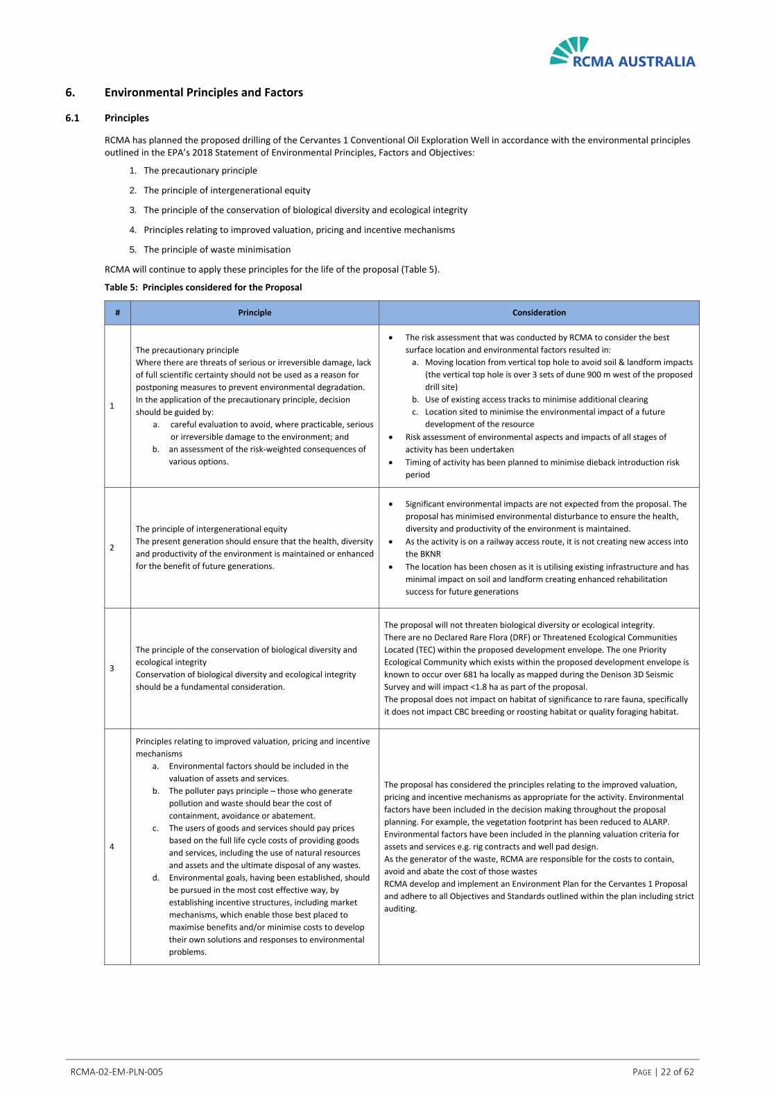
6. Environmental Principles and Factors
6.1 Principles
RCMA has planned the proposed drilling of the Cervantes 1 Conventional Oil Exploration Well in accordance with the environmental principles outlined in the EPA’s 2018 Statement of Environmental Principles, Factors and Objectives:
1. The precautionary principle
2. The principle of intergenerational equity
3. The principle of the conservation of biological diversity and ecological integrity
4. Principles relating to improved valuation, pricing and incentive mechanisms
5. The principle of waste minimisation
RCMA will continue to apply these principles for the life of the proposal (Table 5).
Table 5: Principles considered for the Proposal
# Principle Consideration
1
The precautionary principle
Where there are threats of serious or irreversible damage, lack
of full scientific certainty should not be used as a reason for
postponing measures to prevent environmental degradation.
In the application of the precautionary principle, decision
should be guided by:
a. careful evaluation to avoid, where practicable, serious
or irreversible damage to the environment; and
b. an assessment of the risk‐weighted consequences of
various options.
The risk assessment that was conducted by RCMA to consider the best
surface location and environmental factors resulted in:
a. Moving location from vertical top hole to avoid soil & landform impacts
(the vertical top hole is over 3 sets of dune 900 m west of the proposed
drill site)
b. Use of existing access tracks to minimise additional clearing
c. Location sited to minimise the environmental impact of a future
development of the resource
Risk assessment of environmental aspects and impacts of all stages of
activity has been undertaken
Timing of activity has been planned to minimise dieback introduction risk
period
2
The principle of intergenerational equity
The present generation should ensure that the health, diversity
and productivity of the environment is maintained or enhanced
for the benefit of future generations.
Significant environmental impacts are not expected from the proposal. The
proposal has minimised environmental disturbance to ensure the health,
diversity and productivity of the environment is maintained.
As the activity is on a railway access route, it is not creating new access into
the BKNR
The location has been chosen as it is utilising existing infrastructure and has
minimal impact on soil and landform creating enhanced rehabilitation
success for future generations
3
The principle of the conservation of biological diversity and
ecological integrity
Conservation of biological diversity and ecological integrity
should be a fundamental consideration.
The proposal will not threaten biological diversity or ecological integrity.
There are no Declared Rare Flora (DRF) or Threatened Ecological Communities
Located (TEC) within the proposed development envelope. The one Priority
Ecological Community which exists within the proposed development envelope is
known to occur over 681 ha locally as mapped during the Denison 3D Seismic
Survey and will impact <1.8 ha as part of the proposal.
The proposal does not impact on habitat of significance to rare fauna, specifically
it does not impact CBC breeding or roosting habitat or quality foraging habitat.
4
Principles relating to improved valuation, pricing and incentive
mechanisms
a. Environmental factors should be included in the
valuation of assets and services.
b. The polluter pays principle – those who generate
pollution and waste should bear the cost of
containment, avoidance or abatement.
c. The users of goods and services should pay prices
based on the full life cycle costs of providing goods
and services, including the use of natural resources
and assets and the ultimate disposal of any wastes.
d. Environmental goals, having been established, should
be pursued in the most cost effective way, by
establishing incentive structures, including market
mechanisms, which enable those best placed to
maximise benefits and/or minimise costs to develop
their own solutions and responses to environmental
problems.
The proposal has considered the principles relating to the improved valuation,
pricing and incentive mechanisms as appropriate for the activity. Environmental
factors have been included in the decision making throughout the proposal
planning. For example, the vegetation footprint has been reduced to ALARP.
Environmental factors have been included in the planning valuation criteria for
assets and services e.g. rig contracts and well pad design.
As the generator of the waste, RCMA are responsible for the costs to contain,
avoid and abate the cost of those wastes
RCMA develop and implement an Environment Plan for the Cervantes 1 Proposal
and adhere to all Objectives and Standards outlined within the plan including strict
auditing.

RCMA‐02‐EM‐PLN‐005 PAGE | 23 of 62
# Principle Consideration
5
The principle of waste minimisation.
All reasonable and practicable measures should be taken to
minimise the generation of waste and its discharge into the
environment.
The proposal will generate minimal waste streams. Key waste streams have been
evaluated and management techniques identified to minimise environmental
impacts.
RCMA will implement the hierarchy of waste minimisation:
Avoid
Reuse
Recycle
Treat / dispose
Examples include:
Cuttings will be shaken from muds and muds reused during drilling
Oily waste will be taken offsite by an oily waste recycling provider
Scrap steel will be recycled

RCMA‐02‐EM‐PLN‐005 PAGE | 24 of 62
7. Identification of Key Environmental Factors
Table 6 outlines the environmental factors listed in the EPA’s 2018 Statement of Environmental Principles, Factors and Objectives and their applicability to the drilling of the Cervantes 1 Conventional Oil Exploration Well.
Of the environmental factors listed, the likely significant factors are flora and vegetation, terrestrial fauna and inland waters. These factors are addressed in Sections 7.1, 7.2 and 7.3. Factors that were not considered key environmental factors but have been described in Section 7.4 are labelled ‘Other’.
Table 6: Key Environmental Factors Relevance to the Proposal
Factor Objective Relevance to Proposal Key Factor
Sea
Benthic Communities and Habitat
To protect benthic communities and habitat so that biological diversity and ecological integrity are maintained.
No impacts to benthic habitats No
Coastal Processes To maintain the geophysical processes that shape coastal morphology so that the environmental values of the coast are protected.
No impacts to coastal processes. No
Marine environmental quality
To maintain the quality of water, sediment and biota so that environmental values are protected.
No impacts to marine environmental quality No
Marine fauna To protect marine fauna so that biological diversity and ecological integrity are maintained.
No impacts to marine fauna. No
Land
Flora and Vegetation To protect flora and vegetation so that biological diversity and ecological integrity are maintained.
Clearing of Native Vegetation to support drill pad and access
Potential indirect impacts from dust, weeds and dieback
Yes
Landforms To maintain the variety and integrity of significant physical landforms so that environmental values are protected.
Cervantes 1 is a deviated conventional oil exploration well, the surface location chosen to avoid impact on nearby sand dunes so that environmental values are protected
No
Subterranean Fauna To protect subterranean fauna so that biological diversity and ecological integrity are maintained.
The short duration confined impact (<5m radius around wellbore) in a confined depth zone during drilling along with WBM, casing and cement design will ensure that stygofauna will not be adversely affected
There will be no onsite groundwater abstraction or dewatering
No
Terrestrial Environmental Quality
To maintain the quality of land and soils so that environmental values are protected.
Soil contamination from a potential diesel spill
Failure to manage waste satisfactorily Other
Terrestrial Fauna To protect terrestrial fauna so that biological diversity and ecological integrity are maintained.
Clearing of fauna habitat
Vehicle collision
Potential indirect impacts from waste, pond access
Yes
Water
Inland Waters To maintain the hydrological regimes and quality of groundwater and surface water so that environmental values are protected.
Groundwater contamination
Over abstraction of groundwater Yes
Air
Air Quality To maintain air quality and minimise emissions so that environmental values are protected.
Minimal, temporary impacts not affecting environmental values from:
Diesel combustion emissions from the drilling rig, heavy vehicles and passenger vehicles
Dust generation from vehicles
Emergency flaring
Other
People
Social Surroundings To protect social surroundings from significant harm. Location is remote from residential areas; noise and visual amenity will not create an issue.
Other
Human Health To protect human health from significant harm. No adverse human health impacts expected. No

RCMA‐02‐EM‐PLN‐005 PAGE | 25 of 62
7.1 Key Environmental Factor – Flora and Vegetation
EPA Objective
To protect flora and vegetation so that biological diversity and ecological integrity are maintained.
Legislation, Policy and Guidance
Environmental Protection Act 1986
Environmental Protection (Clearing of Native Vegetation) Regulations 2004
Biodiversity Conservation Act 2016
Environment Protection and Biodiversity Conservation Act 1999
Technical Guidance Flora and Vegetation Surveys for Environmental Impact Assessment
Environmental Factor Guideline Flora and Vegetation
Protection of Naturally Vegetated Areas Through Planning and Development, Environmental Protection Bulletin No. 20
Matters of National Environmental Significance: Significant Impact Guidelines 1.1 (Commonwealth of Australia 2013)
Receiving Environment
Desktop
The Desktop Study Area and Proposed Development Envelope (Figure 2) have been subjected to a number of previous surveys (Table 7) which have provided good contextual information for the Cervantes 1 Flora Assessment of the proposed development envelope conducted for this Referral (Appendix E).
Table 7: Baseline Field Surveys – Flora and Vegetation
Year
Completed Consultant Survey Name
2003 Hart, Simpson and
Associates Pty Ltd.
Proposed EP 413 Denison 3D Seismic Survey Flora and
Fauna Investigation ‐ prepared for Origin Energy
2003 Woodman
Environmental
Cliff Head Development Oil Pipeline and Processing
Plant Flora, Vegetation and Phytophthora cinnamomi
Survey – prepared for ROC Oil Company Ltd. (ROC Oil)
2005 Woodman
Environmental
Denison 3D Seismic Survey Flora and Vegetation Study –
prepared for ARC Energy Pty Ltd / Origin Energy
2020 Woodman
Environmental
Cervantes 1 Conventional Well ‐ Level 1 Fauna Survey,
Reconnaissance and Targeted Flora and Vegetation
Survey (Appendix E)
Although some of these surveys were undertaken 15 ‐ 16 years ago, the surveys that have been undertaken are reliable and comprehensive (Woodman 2020a). This includes the Denison 3D Seismic Survey Flora and Vegetation Study (Woodman Environmental 2005) which covers the entire proposed development envelope and the majority of intact vegetation in the Desktop Study Area.

RCMA‐02‐EM‐PLN‐005 PAGE | 26 of 62
Figure 2: Desktop Area / Proposed Development Envelope
RCMA‐02‐EM‐PLN‐005 PAGE | 27 of 62
Regional Biogeography
The proposal is within the Geraldton Sandplains IBRA (Interim Biogeographic Regionalisation for Australia) Bioregion (DoEE 2012). The vegetation of the region is described as scrub heath on sandplains near the coast, composed mainly of proteaceous shrub‐heaths, rich in endemics, on the sandy earths of an extensive, undulating, lateritic sandplain (Beard 1990; Desmond and Chant 2001).
The proposal occurs specifically within the Geraldton Sandplains 3 (Lesueur Sandplain) subregion. The subregion contains shrub‐heaths rich in endemics occurring on a mosaic of lateritic mesas, sandplains, coastal sands and limestones (Desmond and Chant 2001).
Regional Vegetation
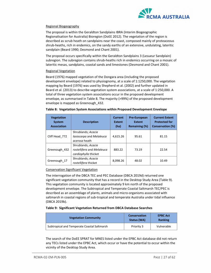
Beard (1976) mapped vegetation of the Dongara area (including the proposed development envelope) related to physiognomy, at a scale of 1:1250,000. The vegetation mapping by Beard (1976) was used by Shepherd et al. (2002) and further updated in Beard et al. (2013) to describe vegetation system associations, at a scale of 1:250,000. A total of three vegetation system associations occur in the proposed development envelope, as summarised in Table 8. The majority (>99%) of the proposed development envelope is mapped as Greenough_432.
Table 8: Vegetation System Associations within Proposed Development Envelope
Vegetation
System
Association
Description
Current
Extent
(ha)
Pre‐European
Extent
Remaining (%)
Current Extent
Protected for
Conservation (%)
Cliff Head_772
Shrublands; Acacia
lasiocarpa and Melaleuca
acerosa heath
4,615.26 95.61 81.15
Greenough_432
Shrublands; Acacia
rostellifera and Melaleuca
cardiophylla thicket
883.22 73.19 22.54
Greenough_17 Shrublands; Acacia
rostellifera thicket 8,098.26 48.02 10.49
Conservation Significant Vegetation
The interrogation of the DBCA TEC and PEC Database (DBCA 2019d) returned one significant vegetation community that has a record in the Desktop Study Area (Table 9). This vegetation community is located approximately 9 km north of the proposed development envelope. The Subtropical and Temperate Coastal Saltmarsh TEC/PEC is described as an assemblage of plants, animals and micro‐organisms associated with saltmarsh in coastal regions of sub‐tropical and temperate Australia under tidal influence (DBCA 2019b).
Table 9: Significant Vegetation Returned from DBCA Database Searches
Vegetation Community Conservation
Status (WA)
EPBC Act
Ranking
Subtropical and Temperate Coastal Saltmarsh Priority 3 Vulnerable
The search of the DoEE SPRAT for MNES listed under the EPBC Act database did not return any TECs listed under the EPBC Act, which occur or have the potential to occur within the vicinity of the Desktop Study Area.

RCMA‐02‐EM‐PLN‐005 PAGE | 28 of 62
Priority Flora
The desktop assessment identified a total of 19 significant flora taxa or habitat for significant taxa, which are known from within the Desktop Study Area including 16 DBCA‐classified Priority flora, and six Threatened flora (Table 10). A likelihood of occurrence assessment taking into account vegetation communities mapped within the proposed development envelope, identified a total of five significant flora taxa (all priority listed taxa) which are considered to potentially occur in the proposed development envelope including Anthocercis intricata (P3), Dampiera tephrea (P2), Eucalyptus zopherophloia (P4), Haloragis foliosa (P3) and Thryptomene sp. Lancelin (M.E. Trudgen 14000) (P3). The remaining 14 significant taxa are considered unlikely to occur primarily because suitable habitat is not considered to be present in the proposed development envelope.
Table 10: Significant Flora Taxa Known from Within the Desktop Study Area
Taxon Status Source*
Acacia telmica P3 DBCA
Anthocercis intricata P3 DBCA; HAS; WEC
Baeckea sp. Walkaway (A.S. George 11249) P3 DBCA; WEC
Beyeria gardneri P3 DBCA
Caladenia hoffmanii Threatened DoEE
Conostylis dielsii subsp. teres Threatened DoEE
Conostylis micrantha Threatened DoEE
Dampiera tephrea P2 DBCA; WEC
Eucalyptus ebbanoensis subsp. photina P4 DBCA
Eucalyptus impensa Threatened DoEE
Eucalyptus zopherophloia P4 DBCA; HAS; WEC
Haloragis foliosa P3 DBCA; HAS
Liparophyllum congestiflorum P4 DBCA
Scholtzia calcicola P2 DBCA
Stawellia dimorphantha P4 DBCA; WEC
Stylidium sp. Three Springs (J.A. Wege & C. Wilkins JAW
600) P2 DBCA
Tetratheca nephelioides Threatened DoEE
Thryptomene sp. Lancelin (M.E. Trudgen 14000) P3 DBCA; WEC
Wurmbea tubulosa Threatened DoEE
*Sources are: DBCA – DBCA WA Herbarium and TPFL Databases (2019c); NatureMap – (DBCA 2007‐); DoEE – DoEE (2020) HAS –Hart, Simpson and Associates (2003); WEC – Woodman Environmental (2005).
P1 ‐ P3: Poorly‐known species
P4: Rare, Near Threatened and other species in need
of monitoring
Threatened: subset of ‘Rare Flora’ under Wildlife
Conservation (Rare Flora) Notice 2018

RCMA‐02‐EM‐PLN‐005 PAGE | 29 of 62
Vegetation Communities
The vegetation of the entire proposed development envelope has been previously mapped as part of the Denison ARC Energy / Origin Energy 3D Seismic Survey Flora and Vegetation Study (Woodman Environmental 2005). A total of four vegetation communities have been mapped within the proposed development envelope (Table 11). In addition, areas of Mobile Dunes have been mapped, described as largely bare with outer slopes characterised by a closed scrub to low closed forest of Acacia rostellifera and Melaleuca cardiophylla. Dune slopes are to be avoided as part of this proposal.
Table 11: Proposed Project Disturbance – Vegetation Communities
Vegetation Community
Area to be
impacted by
Proposal
Area of Community
recorded within Denison 3D
Seismic Survey Study Area
Percentage
Impact on
Community
H8 Heath 3.25 ha 2261.78 ha 0.144%
T2 Dense Melaleuca
thicket 0.07 ha 1528.11 ha 0.004%
T3 Dense Melaleuca
thicket 0.20 ha 591.54 ha 0.034%
W1 Low woodland 1.79 ha 681.07 ha 0.263%
TOTAL 5.31 ha
Introduced Invasive species
A total of 75 introduced taxa or habitat for such taxa are known to occur in the Desktop Study Area (Table 12). Of these five are considered to be significant weeds including Asparagus asparagoides, Lantana camara, Tamarix aphyllaare (Declared Pests and Weeds of National Significance (WoNS)), Echium plantagineum (Declared Pest) and Lycium ferocissimum (WoNS).
Table 12: Introduced Taxa Known from Within the Desktop Study Area
Taxon Common Name Source* Comments
Agave americana Century Plant DBCA; WEC
Alternanthera pungens Khaki Weed DBCA
Arctotheca calendula Cape Weed WEC
Asparagus asparagoides Bridal Creeper DoEE Declared Pest;
WoNS
Asphodelus fistulosus Onion Weed DBCA; WEC
Avena barbata Bearded Oat WEC
Brassica tournefortii Mediterranean Turnip WEC
Briza maxima Blowfly Grass WEC
Briza minor Shivery Grass WEC
Bromus diandrus Great Brome WEC

RCMA‐02‐EM‐PLN‐005 PAGE | 30 of 62
Taxon Common Name Source* Comments
Cakile maritima Sea Rocket DBCA; WEC
Cenchrus ciliaris Buffel Grass DoEE
Cenchrus echinatus Burrgrass DBCA
Cenchrus longisetus Feathertop WEC
Cenchrus setaceus Fountain Grass DBCA; WEC
Chenopodium murale Nettle‐leaf Goosefoot DBCA
Centaurea melitensis Maltese Cockspur WEC
Chenopodium murale Nettle‐leaf Goosefoot WEC
Cotula bipinnata Ferny Cotula WEC
Cuscuta epithymum Lesser Dodder WEC
Cynodon dactylon Couch WEC
Dischisma arenarium Dischisma DBCA; WEC
Echium plantagineum Paterson's Curse DBCA; WEC Declared Pest
Eragrostis curvula African Lovegrass DBCA
Erodium cicutarium Common Storksbill WEC
Euphorbia peplus Petty Spurge WEC
Euphorbia terracina Geraldton Carnation Weed DBCA; WEC
Galium murale Small Goosegrass DBCA
Glebionis coronaria Summer Chrysanthemum DBCA
Hordeum leporinum Barley Grass WEC
Hyparrhenia hirta Tambookie Grass DBCA
Hypochaeris glabra Smooth Cats‐ear WEC
Lamarckia aurea Goldentop WEC
Lantana camara Common Lantana DoEE Declared Pest;
WoNS
Lolium rigidum Wimmera Ryegrass WEC
Lycium ferocissimum African Boxthorn DBCA; DoEE;
WEC WoNS
Lysimachia arvensis Pimpernel WEC
Medicago polymorpha Burr Medic WEC
Melilotus indicus ‐ WEC
Melinis repens ‐ WEC

RCMA‐02‐EM‐PLN‐005 PAGE | 31 of 62
Taxon Common Name Source* Comments
Monoculus monstrosus ‐ WEC
Nicotiana glauca Tree Tobacco DBCA
Oenothera drummondii
subsp. drummondii Beach Evening Primrose DBCA
Oenothera stricta subsp.
stricta
Common Evening
Primrose DBCA
Oxalis pes‐caprae Soursob WEC
Parentucellia latifolia Common Bartsia WEC
Pelargonium capitatum Rose Pelargonium WEC
Pentameris airoides False Hairgrass WEC
Petrorhagia dubia ‐ WEC
Phoenix dactylifera Date Palm WEC
Piptatherum miliaceum Rice Millet WEC
Polycarpon tetraphyllum Fourleaf Allseed WEC
Raphanus raphanistrum Wild Radish WEC
Reichardia tingitana False Sowthistle DBCA
Ricinus communis Castor Oil Plant WEC
Schinus molle Peppercorn Tree DBCA
Schismus barbatus Kelch Grass DBCA
Schinus terebinthifolia ‐ WEC
Sisymbrium orientale Indian Hedge Mustard WEC
Solanum nigrum Black Berry Nightshade WEC
Sonchus oleraceus Common Sowthistle DBCA; WEC
Spergula arvensis Corn Spurry WEC
Spergula pentandra Five Anther Spurry WEC
Spergularia ?rubra Sand Spurry WEC
Symphyotrichum
squamatum Bushy Starwort WEC
Tamarix aphylla Athel Tree DoEE Declared Pest;
WoNS
Taraxacum khatoonae Dandelion WEC
Tetragonia decumbens Sea Spinach WEC
Trifolium arvense Hare's Foot Clover WEC
Trifolium campestre Hop Clover WEC

RCMA‐02‐EM‐PLN‐005 PAGE | 32 of 62
Taxon Common Name Source* Comments
Trifolium hirtum Rose Clover WEC
Ursinia anthemoides Ursinia WEC
Verbesina encelioides Crownbeard DBCA
?Vulpia bromoides Squirrel Tail Fescue WEC
Vulpia muralis ‐ WEC
*Sources are:
DoEE – DoEE (2020);
DBCA – DBCA (2007‐);
WEC – Woodman Environmental (2003, 2005).

RCMA‐02‐EM‐PLN‐005 PAGE | 33 of 62
Field Survey
A reconnaissance and targeted flora and vegetation survey was undertaken in 2020 (Appendix E).
Significant Flora
No significant flora was recorded within the Development Envelope during targeted searching in 2020. It is unlikely that the taxa would occur in the development envelope (Appendix E).
Vegetation Types
Vegetation type mapping undertaken in 2020 over the development envelope is presented in Figures 3 to 6 and vegetation community observations are presented in Table 13.
It is considered that vegetation community W1 represents the state listed PEC ‘Copastal sands dominated by Acacia rostellifera, Eucalyptus oraria and Eucalyptus obtusiflora’ (P1). This PEC is described as floristically similar to other Acacia rostellifera communities but is differentiated on structure, being dominated by mallee eucalypts. The vegetation community occurs on limestone ridges, in some swales in the coastal dunes between Cape Burney and Dongara, on the Greenough Alluvial Flats on limestone soil and near Tarcoola Beach. Some very small occurrences have also been recorded on the limestone scarp north of the Buller River (DBCA 2019b).
This PEC was mapped locally over 681 ha during the Denison 3D Seismic Survey and the area of impact within the proposed development envelope constitutes 0.263% of this area as presented in Figure 7.
Vegetation Condition
The condition of the majority of the vegetation in the proposed development envelope was rated Excellent. Generally, there was little evidence of unnatural disturbance, with weeds generally absent or at very low levels across the area. The vegetation condition subjected to edge effects when in proximity to vehicle tracks was generally rated as Good, with small areas rated as Degraded.
Dieback
The environmental conditions surrounding the Project Area such as low rainfall, sandy calcareous soils which provide good water drainage and unsuitable pH reduces the risk of dieback infestation to very low.
There was no evidence of dieback disease (Phytophthora cinnamomi) identified by field observations at the time of the 2004 survey in the vicinity of the proposed development envelope (>5 km)(Woodman Environmental 2005). This status is not expected to have changed due to the nature of the soils and vegetation and the lack of rainfall received in the area.
There was no evidence of dieback disease identified by field observations at the time of the 2020 survey in the proposed development envelope.

RCMA‐02‐EM‐PLN‐005 PAGE | 34 of 62
Figure 3: Vegetation Type Mapping ‐ North West

RCMA‐02‐EM‐PLN‐005 PAGE | 35 of 62
Figure 4: Vegetation Type Mapping ‐ North East

RCMA‐02‐EM‐PLN‐005 PAGE | 36 of 62
Figure 5: Vegetation Type Mapping ‐ Central

RCMA‐02‐EM‐PLN‐005 PAGE | 37 of 62
Figure 6: Vegetation Type Mapping ‐ Southern

RCMA‐02‐EM‐PLN‐005 PAGE | 38 of 62
Table 13: Proposed Development Envelope Vegetation Communities
VT Description Image
H8
Tall to mid open shrubland of Acacia
rostellifera, Melaleuca cardiophylla,
Melaleuca huegelii subsp. huegelii and
Santalum acuminatum over low sparse
shrubland of Melaleuca systena over low
open sedgeland of Gahnia sp. South West
(K.L. Wilson & K. Frank KLW 9266) on grey
clayey sand in swales between dunes.
Plate 1: Vegetation Type H8 ‐
Releve MET06
T2
Tall closed shrubland of Melaleuca
cardiophylla and/or Melaleuca huegelii
subsp. huegelii on slopes of grey‐brown
sandy loam.
Plate 2: Vegetation Type T2 ‐
Releve MET12
T3
Tall closed shrubland to low sparse
shrubland of Acacia rostellifera,
Melaleuca cardiophylla, Melaleuca
huegelii subsp. huegelii, Melaleuca
systena, Olearia sp. Kennedy Range (G.
Byrne 66) over low sedgeland of
Lepidosperma calcicola on flats of grey‐
brown sandy loam.
Plate 3: Vegetation Type T3 ‐
Releve MET02
W1
Mid open to closed mallee forest of
Eucalyptus obtusiflora subsp.
dongarraensis and Eucalyptus oraria over
mid to tall sparse shrubland of Melaleuca
cardiophylla and Melaleuca huegelii
subsp. huegelii, with occasional Acacia
rostellifera and Melaleuca lanceolata on
slopes of grey sand.
Plate 4: Vegetation Type W1 ‐
Quadrat MET09

RCMA‐02‐EM‐PLN‐005 PAGE | 39 of 62
Figure 7: Vegetation Type W1 Mapped Widely as part of Denison 3D Project

RCMA‐02‐EM‐PLN‐005 PAGE | 40 of 62
Potential Impacts
The well has been located specifically to avoid the sensitive dunes in the BKNR and minimise clearing by utilising existing tracks to the well pad.
Direct Impacts
Loss of native vegetation due to clearing.
Indirect Impacts
In addition to direct impacts to vegetation and flora arising from the proposal, the following indirect impacts to vegetation and flora may arise:
Introduction or spread of non‐indigenous species (weed / pathogens)
Accidental clearing of areas outside of the proposed development envelope
Indirect impacts identified for the proposal are considered standard impacts for projects within and adjacent to native vegetation that can be suitably managed via standard mitigation measures.
Unlikely indirect impact is the introduction of dieback.
Assessment of Impacts
Regional and Local Significance
The well has been located specifically to avoid the sensitive dunes in the BKNR and minimise clearing by utilising existing tracks to the well pad.
Table 14 presents the current extent of each vegetation system association in relation to the area to be impacted by the proposal. As a temporary project which will be rehabilitated, the impact on the regional vegetation system is not significant (<0.6%).
Table 14: Vegetation Systems Disturbance
Vegetation System
Association
Current Regional
Extent (ha)
Area to be impacted
by Proposal
Impact on Regional
Vegetation
Cliff Head_772 4,615.26 ha 0.04 ha 0.00%
Greenough_432 883.22 ha 5.26 ha 0.57%
Greenough_17 8,098.26 ha 0.01 ha 0.00%
TOTAL 5.31 ha
Locally, the vegetation communities to be impacted include H8, W1, T2 and T3 with the majority of clearing proposed to occur within H8 and W1. Potential impacts of the proposal on any single vegetation community are presented in Table 15. Proposed impacts on these vegetation communities are considered very low with proposed impacts to vegetation communities all well below 1% of the area recorded for each during the Denison 3D Seismic Survey.
Vegetation community W1 has affinities with the Coastal sands dominated by Acacia rostellifera, Eucalyptus oraria and Eucalyptus obtusiflora PEC (P1). The proposal will not

RCMA‐02‐EM‐PLN‐005 PAGE | 41 of 62
have a significant impact on this vegetation type (<0.263%) as identified during the Denison 3D Seismic Survey and presented in Table 15 and Figure 7.
Table 15: Proposed Vegetation Communities Disturbance
Vegetation
Community
Area to be impacted by
Proposal
Area of Community
recorded locally***
Percentage Impact on
Community
H8 3.25 ha 2261.78 ha 0.134%
T2 0.07 ha 1528.11 ha 0.004%
T3 0.20 ha 591.54 ha 0.034%
W1 1.79 ha 681.07 ha 0.263%
TOTAL 5.31 ha
***within Denison 3D Seismic Survey Study Area
Conservation Significant Vegetation
There are no significant flora records from within the proposed development envelope area (5 km). The significant flora risk assessment identified five conservation significant flora taxa that could potentially occur within the proposed development envelope. The field survey was undertaken at a suitable time for identifying these taxa and no individuals were identified during the survey.
Given the relatively minor impacts to the vegetation communities presented in Table 15 and based on the absence of conservation significant taxa within the proposed development envelope, any potential impacts of the proposal are not significant.
Avoidance and Mitigation
Vegetation Impact Minimisation
RCMA will commission a targeted survey of the Project area in Spring 2020 to characterise the annual component of the flora and confirm the findings of the March 2020 Reconnaissance and Targeted survey. This survey will focus on the project area only and will determine whether any of the additional flora taxa recorded in Spring are conservation significant.
The following measures have been identified to avoid / minimise the impact on vegetation as part of the proposal:
Wellpad location has been chosen to minimise clearing and avoid all sensitive dune vegetation
Existing tracks have been selected as an access route to minimise the required clearing for the proposal
Personnel will be accommodated in an offsite camp to avoid clearing of vegetation associated with the proposal
Areas to be cleared will be demarcated prior to clearing activities to ensure that only specified areas to are cleared
Speed limits will be imposed, and no off‐track driving permitted (including dedicated parking spaces) for all proposal areas

RCMA‐02‐EM‐PLN‐005 PAGE | 42 of 62
Vegetation and topsoil will be separately stockpiled in low profile mounds to maximise rehabilitation success
A Vegetation Management Plan will be developed and implemented
Dieback Risk Minimisation Measures
The following measures have been identified to minimise the risk of dieback introduction (and therefore indirect impacts on vegetation):
Imported material for the tracks and drill pad will be limestone marl sourced from a nearby quarry to minimise the risk of dieback introduction
A DBCA‐approved Hygiene Management Plan including hygiene management measures such as equipment and vehicle clean down will be in place for the proposal
Predicted Outcomes
The clearing associated with the proposal is limited and any impacts to flora and vegetation will not be significant. The outcomes of the proposal are predicted to be:
No impact to conservation significant species
An extremely low (0.263%) impact on the widely mapped W1 Priority Ecological Community (P1)
Clearing 5.3 ha native vegetation
No detrimental impacts to adjacent vegetation through the implementation of an Environment Plan and associated Vegetation and Hygiene Management Plans
Based upon the nature and scale of the vegetation and flora impacts associated with this proposal and with the mitigations identified, biological diversity and ecological integrity of vegetation will be maintained and the EPA Objective for this factor can be met for the proposal.
Based upon the predicted outcomes for the proposal, RCMA does not believe that it will result in a significant impact to flora and vegetation. RCMA has considered the WA Environmental Offsets Policy however RCMA does not believe actions to offset the predicted outcomes of this proposal are required as the proposal is not expected to have a significant impact to flora and vegetation.
RCMA believes that the provisions of the Petroleum and Geothermal Energy Resources (Environment) Regulations 2012 provide a suitable framework for the management of this proposal without the need for referral under Part IV of the Environmental Protection Act 1986.

RCMA‐02‐EM‐PLN‐005 PAGE | 43 of 62
7.2 Key Environmental Factor – Terrestrial Fauna
EPA Objective
To protect terrestrial fauna so that biological diversity and ecological integrity are maintained.
Legislation, Policy and Guidance
Biodiversity Conservation Act 2016
Environment Protection and Biodiversity Conservation Act 1999
Environmental Factor Guideline Terrestrial Fauna
Technical Guidance Sampling methods for Terrestrial Vertebrate Fauna
Technical Guidance Terrestrial Fauna Surveys
Receiving Environment
Terrestrial Fauna Studies
The desktop study (Appendix E) identified 207 fauna species as potentially occurring in the proposed development envelope including nine frogs, 50 reptiles, 122 birds, 16 native and ten introduced mammals (Table 16). The assemblage is likely to be typical of the coastal belt of the Geraldton Sandplains bioregion, however, this overall assemblage is unusual and has a limited distribution from just north of Perth to south of Dongara. The fauna assemblage of the proposed development envelope is reasonably complete except for many species of medium‐sized and small mammals which have become locally extinct, as is common throughout the region.
Table 16: Composition of vertebrate fauna assemblage
Taxon
Number of
Species
Expected
Number of species in each category
Resident
Regular
Visitor or
Migrant
Irregular
Visitor Vagrant
Locally
Extinct
Fish 0 0 0 0 0 0
Frog 9 8 1 1 0 0
Reptiles 50 49 0 0 0 1?
Birds 122 39 40 26 16 1?
Native
Mammals 16 12 3 1 0 12
Introduced
Mammals 10 5 0 3 2 ‐
Total 207
113 44 30 18 12 (+2?) (including 14 int.)

RCMA‐02‐EM‐PLN‐005 PAGE | 44 of 62
The proposed development envelope is comprised mostly of heath vegetation that supports a rich reptile assemblage and understorey‐associated birds. The strip of Melaleuca thickets in the east may support additional middle‐storey birds and some larger mammals. The small area of mallee woodland in the east is expected to support woodland‐associated species.
The fauna assemblage includes a total of 15 vertebrate species of significance and four invertebrate species of significance (Table 17).
Table 17: Conservation Significant Fauna Species Expected to Occur
CS Species Status CS Level Expected Status
INVERTEBRATES
millipede Antichiropus Eneabba 1 CS3 Resident
Bush Cricket Hemisaga vepreculae P2 CS2 Resident
Springtime Corroboree
Stick Katydid Phasmodes jeeba P3 CS2 Resident
native bee Hylaeus globuliferus P3 CS2 Resident
REPTILES
Woma Aspidites ramsayi P1 CS2 Possibly locally
extinct
Carpet Python Morelia spilota imbricata CS3 Resident
Black‐striped Snake Neelaps calonotos P3 CS2 Resident
BIRDS
Malleefowl Leipoa ocellata Vu S3 CS1 Irregular visitor
Fork‐tailed Swift Apus pacificus Mi S5 CS1 Regular migrant
Letter‐winged Kite Elanus scriptus P4 CS2 Vagrant
Peregrine Falcon Falco peregrinus S7 CS1 Irregular visitor
Rainbow Bee‐eater Merops ornatus CS3 Regular migrant
Carnaby's Black‐
Cockatoo
Calyptorhynchus
latirostris En S2 CS1 Regular migrant
Western Ground Parrot Pezoporus flaviventris Cr S1 CS1 Possibly locally
extinct
Rufous Fieldwren Calamanthus campestris CS3 Resident
Shy Heathwren Calamanthus cautus CS3 Irregular visitor
Crested Bellbird Oreoica gutturalis CS3 Resident
MAMMALS
Little Long‐tailed
Dunnart
Sminthopsis aff.
dolichura CS3 Resident

RCMA‐02‐EM‐PLN‐005 PAGE | 45 of 62
CS Species Status CS Level Expected Status
Brush Wallaby Notamacropus irma P4 CS2 Resident
Total species expected: 19
P1 ‐ P3: Poorly known species
P4: Rare, Near Threatened and other species in need of monitoring
CS1: Species listed under State or Commonwealth Acts
CS2: Species listed as Prioirty by the DBCA but not listed under State or
Commonwealth Acts
CS3: Species not listed under Acts or in publications, but considered of at
least local significance because of their pattern of distribution
Cr: Critically Endangered Species
En: Endangered species
Mi: Migratory species
Vu: Vulnerable spoecies
S1 – S5: Biodiversity Conservation Act 2016
listed species
Three species of threatened invertebrates have records within 50 km of the project area (all >12km away). The Springtime Corroboree Stick Katydid (Phasmodes jeeba) has been collected from near‐coastal vegetation near Jurien and Dongara (Rentz 1996) and is thus very likely to be present. The Thorny Bush Katydid (Hemisaga vepreculae) and Woollybush Bee (Hylaeus globuliferus) are known from the broader area and are included on a precautionary basis. In addition, the millipede Antichiropus Eneabba 1 is a short‐range endemic (SRE) which is found in Eneabba but has also been recorded at Mt Adams, where it is associated with Acacia thickets close to wetlands (Metcalf & Bamford 2008).
Limestone at or close to the surface (such as in vegetation type H8; see Figure 5 and Figure 6) may have a higher likelihood of supporting SRE species than other areas, but the distribution of SRE invertebrates is likely to be more complicated than this. Vegetation type H8 and other vegetation types are extensive in the area compared with the impact footprint. Underlying limestone may be present throughout and can provide habitat for subterranean invertebrate fauna either above (troglofauna) or below (stygofauna) the groundwater level.
Field Survey
Field investigations (Appendix E) supported the results of the desktop study which identified 207 fauna species as potentially occurring in the project area: nine frogs, 50 reptiles, 122 birds, 16 native and ten introduced mammals. The fauna assemblage is fairly complete except for medium sized and small mammals which have been lost as is common throughout the region.
Opportunistic observations were recorded at all times when conducting field investigations. These included casual observations of fauna, records of road‐killed animals or indirect evidence of fauna (e.g. scats, tracks, diggings or foraging evidence). Observations were made along all existing tracks within the survey area.
Carnaby’s Black Cockatoo have been discussed further below as (of the conservation significant fauna species identified in Table 17) there is a specific referral guideline for Carnaby’s Black Cockatoos (SEWPAC 2012) and specific investigation was required in the field.
Carnaby’s Black Cockatoo
Carnaby’s Black‐Cockatoo is considered likely to be a regular migrant in the proposed development envelope. The inland subspecies of the Red‐tailed Black‐Cockatoo may also occur in the area irregularly or as a vagrant, but this is not of conservation significance. The Carnaby’s Black‐Cockatoo forages in proteaceous heath, banksia woodlands and eucalypt woodlands, and based on field survey the proposed development envelope does

RCMA‐02‐EM‐PLN‐005 PAGE | 46 of 62
not support critical foraging habitat. The Carnaby’s Black‐Cockatoo is unlikely to roost or breed in the proposed development envelope due to the lack of large trees, and the proposed development envelope is located within the non‐breeding range of the species (DSEWPC 2012a). The closest published confirmed roost site is located approximately 17 km east of the proposed development envelope, while the closest published confirmed breeding site is located approximately 60 km southeast of the proposed development envelope (DBCA 2007‐). The proposed development envelope has low‐quality foraging habitat for Carnaby’s Black‐Cockatoo (based on site inspection).
Potential Impacts
Indirect Impacts
Potential direct impacts of the proposal on fauna could include:
Clearing of <2.7 ha of vegetated fauna habitat fringing an existing access track for a period of up to 3 months
Clearing of 2.6 ha of vegetated fauna habitat in a previously uncleared vegetated swale for a period of up to 6 months
Vehicle movements on access tracks potentially causing fauna strike over a period of 90 days with most movements (40 each) over two ten‐day periods prior to and post drilling
Noise associated with drilling rig potentially deterring fauna from the vicinity of the drilling rig for up to 40 days
Light emissions during drilling activities for a period up to 40 day could attract fauna although this would be combined with noise
Fauna entrapment in excavations is unlikely due to fauna fencing
Indirect Impacts
Potential indirect impacts of the proposal on fauna could include increased feral animal activity.
Assessment of Impacts
Preliminary risk assessment has identified that potential impacts of the proposal are unlikely to significantly impact fauna values of the area despite the potential presence of several conservation significant taxa in the area. Given the small area of clearing required (5.3 ha) it is likely that impacts on fauna will be minimal.
Impacts to fauna can be managed through the implementation of management measures.
Project Area Size
The project area is small in the context of the coastal belt and region, so the impact of exploration works on the fauna assemblage is expected to be minor and localised. Vegetation and soils are extensive in the region. The loss of foraging habitat for species such as the Carnaby’s Black‐Cockatoo is expected to be negligible due to the small project area size, the low foraging value of the vegetation and presence of similar habitat nearby.

RCMA‐02‐EM‐PLN‐005 PAGE | 47 of 62
Fragmentation
Vegetation clearance may lead to fragmentation and loss of connectivity within the local area. However, clearance for exploration works is expected to be small and rehabilitation across all cleared areas is proposed, so this impact is likely to be negligible.
Fire Frequency
There is the potential for increased fires from introduced human presence and activity in the area, and this has the potential to impact both local and surrounding areas and fauna, especially if the fire is not contained. An emergency response plan will be in place prior to the commencement of works.
Feral Animals
Increased human activity has the potential to attract feral animals to the area which may impact fauna through predation and/or competition. Feral animals will also follow tracks which increases their presence in otherwise undisturbed landscapes. A Fauna Management Plan will be in place prior to commencement of works.
Subterranean Fauna
The soils are highly porous so surface hydrology should not be affected by the activity. Drilling will not interact with sub‐surface hydrology and there will effectively be no vibration, so subterranean fauna will not be impacted in more than the immediate vicinity of the well bore (<5 m). Surface excavation and soil disturbance are also limited to the immediate vicinity of the well bore. The EPA (2016e) recommends that if there is a high likelihood of subterranean fauna being present, and where the impact is expected to be low, then low‐intensity sampling for subterranean fauna should be carried out. In this case, however, while there is a high likelihood of subterranean fauna being present (extensive sub‐surface limestone), this habitat is widespread and the area of impact is extremely small; the impact is therefore considered to be negligible in the context of available habitat.
Dust, Light, Disturbance and Noise
Impacts of these are difficult to predict and depend on the level of existing disturbance in the area which is likely to be low. Night operations using lighting may cause an increase in fauna mortality and should be avoided. These impacts will be temporary for the period of exploration activity (c. 90 days (<40 days for light disturbance)).
Carnaby’s Black Cockatoo
The potential loss of foraging habitat for species such as the Carnaby’s Black‐Cockatoo is expected to be negligible due to the small proposed impact area, the low‐quality foraging value of the vegetation and presence of similar habitat nearby. Referral of the proposal for this species would be required if >1 ha of quality foraging habitat was to be impacted, however based on site inspection the foraging habitat is of low quality. Therefore, referral of the proposal on this basis is not considered necessary.

RCMA‐02‐EM‐PLN‐005 PAGE | 48 of 62
Avoidance and Mitigation
A Fauna Management Plan will be developed and implemented.
Habitat Impact Avoidance
The following measures have been identified to avoid the impact on fauna as part of the proposal:
Existing tracks have been selected as an access route to minimise the required clearing of fauna habitat for the proposal
Personnel will be accommodated in an offsite camp to avoid clearing of fauna habitat associated with the proposal
To protect stygofauna, there will be no onsite abstraction of groundwater or dewatering
Operations
The following measures have been identified to reduce the impact on fauna as part of the proposal:
Construction is to be undertaken during daylight hours only to avoid fauna being attracted to vehicle lights
Lighting during all phases of the proposal will be directed on operational areas only to minimise fauna attraction to light spill
Excavations such as the mud sump and Turkey’s Nest will have fauna exclusion fencing and fauna escape mechanisms
All waste will be stored in appropriately covered receptacles to exclude fauna before being removed from site
Predicted Outcomes
The outcomes of the proposal are predicted to be:
No significant impact on the 19 conservation significant fauna species possibly occurring in the region
No impacts to Carnaby’s Black‐Cockatoo breeding / roosting habitat
Negligible Carnaby’s Black‐Cockatoo foraging habitat loss due to the small proposed impact area and the low‐quality foraging value of the vegetation
Clearing of 5.3 ha vegetation that could result in fauna strike
Temporary localised disturbance to local fauna populations arising from dust, light and noise for duration of proposal (<3 months)
Based upon the nature and scale of the terrestrial fauna impacts associated with this proposal and with the mitigations identified, significant impacts to biological diversity and ecological integrity are not expected and thus the EPA Objective for this factor will be met.
RCMA has received advice that due to the small area of low‐quality Carnaby’s Black Cockatoo foraging habitat that will be impacted by the proposal, no referrals are required for the project.

RCMA‐02‐EM‐PLN‐005 PAGE | 49 of 62
Based upon the predicted outcomes for the proposal, RCMA does not believe that it will result in a significant impact to terrestrial fauna. RCMA has considered the WA Environmental Offsets Policy however RCMA does not believe actions to offset the predicted outcomes of this proposal are required as the proposal is not expected to have a significant impact to terrestrial fauna.
RCMA believe that the provisions of the Petroleum and Geothermal Energy Resources (Environment) Regulations 2012 provide a framework for the management of this proposal without the need for referral under Part IV of the Environmental Protection Act 1986.
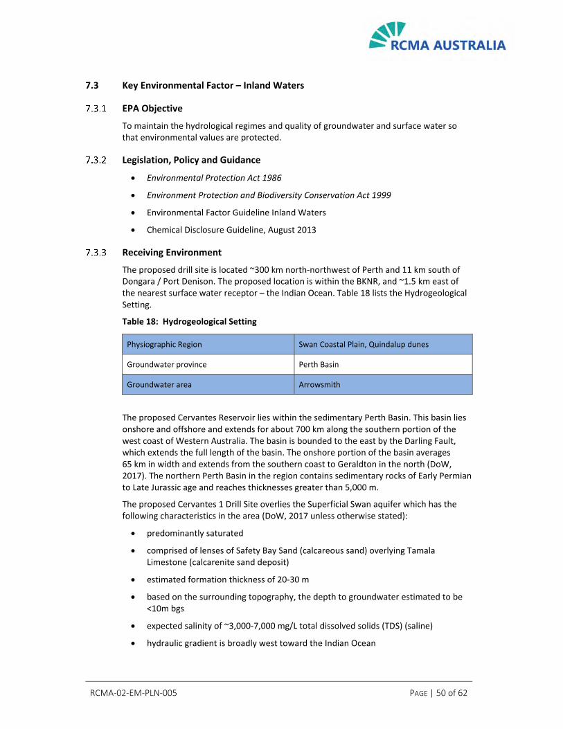
RCMA‐02‐EM‐PLN‐005 PAGE | 50 of 62
7.3 Key Environmental Factor – Inland Waters
EPA Objective
To maintain the hydrological regimes and quality of groundwater and surface water so that environmental values are protected.
Legislation, Policy and Guidance
Environmental Protection Act 1986
Environment Protection and Biodiversity Conservation Act 1999
Environmental Factor Guideline Inland Waters
Chemical Disclosure Guideline, August 2013
Receiving Environment
The proposed drill site is located ~300 km north‐northwest of Perth and 11 km south of Dongara / Port Denison. The proposed location is within the BKNR, and ~1.5 km east of the nearest surface water receptor – the Indian Ocean. Table 18 lists the Hydrogeological Setting.
Table 18: Hydrogeological Setting
Physiographic Region Swan Coastal Plain, Quindalup dunes
Groundwater province Perth Basin
Groundwater area Arrowsmith
The proposed Cervantes Reservoir lies within the sedimentary Perth Basin. This basin lies onshore and offshore and extends for about 700 km along the southern portion of the west coast of Western Australia. The basin is bounded to the east by the Darling Fault, which extends the full length of the basin. The onshore portion of the basin averages 65 km in width and extends from the southern coast to Geraldton in the north (DoW, 2017). The northern Perth Basin in the region contains sedimentary rocks of Early Permian to Late Jurassic age and reaches thicknesses greater than 5,000 m.
The proposed Cervantes 1 Drill Site overlies the Superficial Swan aquifer which has the following characteristics in the area (DoW, 2017 unless otherwise stated):
predominantly saturated
comprised of lenses of Safety Bay Sand (calcareous sand) overlying Tamala Limestone (calcarenite sand deposit)
estimated formation thickness of 20‐30 m
based on the surrounding topography, the depth to groundwater estimated to be <10m bgs
expected salinity of ~3,000‐7,000 mg/L total dissolved solids (TDS) (saline)
hydraulic gradient is broadly west toward the Indian Ocean

RCMA‐02‐EM‐PLN‐005 PAGE | 51 of 62
groundwater recharge is predominantly via rainfall, and upward groundwater flow from the underlying Yarragadee aquifer is expected in areas where the aquifers are hydraulically connected (Nidagal 1995; Irwin 2007)
groundwater discharges predominantly into the ocean at the coast over a seawater interface, which may be encountered up to 1.5 km inland (Moncrieff & Tuckson, 1989)
The Yarragadee Formation is the main formation that sub‐crops in the area and underlies the Superficial aquifer in the vicinity of the Cervantes 1 Drill Site, where it has an expected thickness of ~400 m and expected salinity of ~7,000‐14,000 mg/L TDS (saline). The Yarragadee aquifer is the largest regional aquifer in the northern Perth Basin and consists of a multilayered sequence of sandstone beds with very fine to very coarse grained and granule sized quartz sand with variable amounts of matrix clay and interbedded siltstone, shale and claystone (DoW, 2017).
Groundwater recharge into the Yarragadee is mostly by direct rainfall (east of the Swan Coastal Plain), as well as downward leakage from overlying aquifers and river recharge. Groundwater also discharges from the Yarragadee via upward flow into overlying aquifers, such as in the vicinity of Cervantes 1 Drill Site, and some groundwater discharges offshore into the Indian Ocean (DoW, 2017).
Formations which underlie the Yarragadee aquifer, such as the Cattamarra Coal Measures and Eneabba Formation, which in other areas can contain fresh groundwater, occur at considerable depth within the area and are likely to contain brackish to saline groundwater (DoW, 2017). Although some connectivity exists between the aquifers, it is impeded by several confining layers (Rockwater, 2015).
A search of the Department of Water and Environmental Regulation (DWER) online registered groundwater abstraction bores in the vicinity of the site indicated that the nearest registered groundwater bore is located ~3.0 km north‐east and up‐hydraulic gradient (inferred) of the site (AWRC #70110399) and is understood to have historically been used for water supply to the abandoned Dooka gypsum mine. The remaining five bores listed in the vicinity of 70110399 are used for supply, monitoring and injection associated with JPF.
Due to the up‐gradient location, separation distance and use of the abovementioned groundwater bores, human receptors using these bores are not considered to be at risk of exposure to contaminants associated with future proposed drilling or production activities at the Cervantes 1 Drill Site.
The nearest potential human receptors in the vicinity of the site are farm residents ~2.6 km north‐northeast – up and across hydraulic gradient of the site. No human receptors exist down‐hydraulic gradient of the site i.e., between the site and the Indian Ocean.
The Allanooka‐Dongara Water Reserve (P1) represents the nearest Public Drinking Water Source protection area (PDWSA) and is located ~18 km to the north‐northeast of the site (DoW, 2010).
No DWER environmentally sensitive areas, DBCA important wetlands, RAMSAR sites, Rights in Water and Irrigation Act 1914 (RIWI) surface water areas or irrigation districts are located within 5 km of the site. The proposed site is located within the Arrowsmith RIWI Groundwater Area.

RCMA‐02‐EM‐PLN‐005 PAGE | 52 of 62
The following information provided on Groundwater Dependent Ecosystems (GDEs) was sourced from the Bureau of Meteorology (BoM, 2019) and the Department of Water (DoW, 2017). GDEs are natural ecosystems that require access to groundwater to meet all or some of their water requirements on a permanent or intermittent basis. Potential GDEs in the vicinity of the site predominantly exist as native vegetation overlying a shallow water table – the Superficial aquifer. These areas are also considered as likely Inflow Dependent Ecosystems (IDEs) – landscapes that are seasonally or permanently wetter than surrounding areas that use and receive water from inflows in addition to rainfall (e.g. surface water, soil water, irrigation).
The identified GDEs and IDEs in this area may be considered potential sensitive receptors for future surface activities associated with the proposed drill site.
No aquatic or subterranean GDEs/IDEs exist within a 5 km radius of the proposed development envelope.
Potential Impacts
Contamination of groundwater from drilling fluids:
Well bore (negligible)
Failure of mud sump liner
Assessment of Impacts
RCMA will select low‐toxicity drilling fluids for drilling the well, and consequently if contamination of groundwater from drilling fluids occurred, it would be expected to result in no more than a localised and temporary impact. As there is little hydraulic connection between the Allanooka – Dongara Water Reserve and the proposed development envelope (18 km) and given the distance to the closest residential ground‐water extraction bore, impacts from this activity are not expected to be significant in the immediate area or regionally.
Monitoring of previous oil and gas drilling programs in the region has not identified any groundwater contamination events.
Avoidance and Mitigation
Measures in place that will protect Inland Waters are outlined below.
Well Construction
The Cervantes 1 Well Construction will be made up of cemented casing strings for the purpose of:
Reaching formations of interest safely and allowing containment of hydrocarbons if intersected.
Maintaining wellbore stability.
Allowing zonal isolation (protection of freshwater aquifers and isolation of hydrocarbon bearing formations).
There is no hydraulic fracture stimulation (‘fraccing’) as part of this project.
Casing strings are secured in place by cement, and both the casing and cement are designed to withstand the environmental conditions they will be exposed to during the

RCMA‐02‐EM‐PLN‐005 PAGE | 53 of 62
life of the well. Well construction design will be detailed within the Well Management Plan that is submitted for assessment and approval by DMIRS.
In the event no hydrocarbons of commercial value are intersected, the well will be plugged and isolated with cement prior to decommissioning and rehabilitation activities.
The surface casing will run to a depth to protect overlying freshwater aquifers. The surface casing in this well will isolate the entire Yarragadee formation.
In the event the well is suspended for future use with a production casing string, this string will be designed to meet any future pumping or producing activity requirements and cemented in place to provide a further integrity barrier for any freshwater aquifers.
Casing integrity will be tested and confirmed when installed during drilling. If the well is then suspended for future activities (eg. well test), pressure gauges on the wellhead are utilised to monitor integrity between the innermost casing string and casing annuli.
Low Toxicity Muds
The WBM planned for the Cervantes 1 Well present a low risk to human health and the environment. The main substances mixed with water to form the WBM include bentonite, potassium chloride, sodium chloride, barite, limestone and stone dust. These ingredients with the water make up approximately 96% of the drill fluids. Although biocides, polymers and oxygen scavengers are present in minor quantities, all the disposed fluids will be contained within a lined mud sump for evaporation.
RCMA will disclose all proposed drilling muds to DMIRS and publicly as per the requirements of the Petroleum and Geothermal Energy Resources (Environment) Regulations 2012 Regulation 15(9).
Mud Sump Design
The mud sump will be lined with Enviro Liner 6030HD liner (hereafter referred to as ‘Enviro Liner’) (Thickness: 0.75 mm; Water Vapour Permeability 3 x 10‐13 cm/sec); this will prevent the vertical migration of contaminants into the underlying soils or the aquifer. The Enviro Liner is the preferred option as the product is flexible, puncture resistant, resistant to UV exposure and suited for the storage of muds and cuttings. The Enviro liner is specifically designed for oilfield applications including use in a high salinity environment. The 0.75 mm Enviro liner can be shop welded as opposed to thicker liners or HDPE liners that must be field welded, thereby providing improved quality control on the welding process. This liner exhibits the axi‐symmetric benefits of an LLDPE liner with the strength properties of the equivalent HDPE liner.
RCMA will ensure a minimum freeboard capacity of approximately 0.5 m is maintained within the mud sump throughout the course of operations. This is a volume sufficient to prevent any overflow as the average annual pan evaporation rate for the Perth Basin is between 2,000‐2,400 mm whilst the average rainfall rates are approximately 600‐800 mm annually (BoM 2019).
Validation Sampling
Groundwater and soil sampling will be undertaken prior to and after proposal activities to confirm that no contamination of groundwater has occurred. Identified issues will be investigated and remediation implemented.

RCMA‐02‐EM‐PLN‐005 PAGE | 54 of 62
Oil Spill Contingency Plan
An OSCP is in place for the proposal to provide a practical reference tool for personnel responding to a spill incident. The OSCP includes:
preparations to be made for the possibility of an oil spill
emergency response arrangements to be implemented if an oil spill occurs
recovery arrangements to be implemented if an oil spill occurs
This plan provides a practical reference to personnel to ensure they have the tools to in place and the reference material to respond to a liquid spill on site which will prevent escalation of an incident and potential groundwater contamination.
Groundwater Abstraction Monitoring
Groundwater will be brought from an offsite already allocated groundwater source. A flowmeter will be in place for the licenced groundwater abstraction bore (2.5 ML) and will be monitored daily during abstraction operations. This will ensure that groundwater resources are not adversely affected by over abstraction from this offsite existing licenced bore.
Sewage Holding Tanks
Sewage resulting from the sewage treatment system will be held in holding tanks on site prior to being taken offsite by a controlled waste carrier to licenced disposal facility. This will ensure that no sewage is left on site, protecting the groundwater from the risks associated with nutrient‐rich water.
Predicted Outcomes
Based upon the predicted outcomes for the proposal, RCMA does not believe that it will result in a significant impact to the inland waters. The Environmental Factor of Inland Waters should be managed under the existing regulatory arrangements under the Petroleum and Geothermal Energy Resources Act 1967 as:
The risk management strategy for sources of risk to Inland Waters as per 7.3.6 above are outlined in the Implementation Strategy of the DMIRS regulated Environment Plan as per the requirements of the Petroleum and Geothermal Energy Resources (Environment) Regulations 2012 Regulation 15
RCMA will disclose all proposed drilling mud chemicals to DMIRS and publicly as per the requirements of the Petroleum and Geothermal Energy Resources (Environment) Regulations 2012 Regulation 15(9)
RCMA has considered the WA Environmental Offsets Policy, however RCMA does not believe actions to offset the predicted outcomes of this proposal are required as the proposal is not expected to have a significant impact to Inland Waters.

RCMA‐02‐EM‐PLN‐005 PAGE | 55 of 62
7.4 Other Environmental Factors
Table 19 outlines potential activities and impacts and their management associated with Other Environmental Factors relevant to the proposal but not considered Key Environmental Factors.
Table 19: Other Environmental Factors and Proposed Management
Factor EPA Objective Description Key Factor? Statute Responsible Agency Proposed Management
Terrestrial Environmental Quality
To maintain the quality of land and soils so that environmental values are protected.
Soil contamination from a potential diesel spill
No
EP Act 1986 DGS Act 2004 PGER Act 1967
DWER DMIRS Resources Safety DMIRS Environment
Large storage tank is self‐bunded
Diesel transfer operations are manned
Spill trays are utilised for all diesel transfers
Spill kits are located as per OSCP
OSCP in place and induction includes the requirements of personnel
Contaminated material is taken offsite for reuse or disposal
Standard operating procedures in place for handling and use of hazardous materials
Bunding of liquid chemicals in accordance with SDS requirements
Bunds are inspected during housekeeping inspections to determine integrity and maintenance of capacity
Drilling sump materials will be taken offsite for disposal / reuse offsite
Validation sampling on site will confirm no potential contamination has been left
Failure to manage waste satisfactorily
EP Act 1986 PGER Act 1967
DWER DMIRS Environment
Use of covered waste receptacles
Specific waste segregation onsite
Bunding of waste hydrocarbon products
Site inductions cover waste management requirements
Offsite disposal through licensed contractors
Air Quality
To maintain air quality and minimise emissions so that environmental values are protected.
Minimal, temporary impacts not affecting environmental values from:
Diesel combustion emissions
Dust generation from vehicles
No EP Act 1986 PGER Act 1967
DWER DMIRS Environment
Nearest resident 2.6 km will be unaffected by dust or vehicle emissions
Speed limits for vehicle traffic imposed across proposed development envelope
Speed limits adhered to in order to reduce dust emissions
Induction includes vehicle speed limits
The application of water (or appropriate suppressants) to access roads, working surfaces and stockpiles (as required)
Water sprayed on soil and /or access track as required
Vehicles and equipment regularly maintained
Drilling rig activity is short duration with <500 t CO2‐e Scope 1 and 2 emissions
Social Surroundings
To protect social surroundings from significant harm.
Location is remote from residential areas; noise and visual amenity will not create an issue
No EP Act 1986 PGER Act 1967
DWER DMIRS Environment
Stakeholder engagement prior to commencement of activity – appropriate engagement method identified
The nearby stakeholders would be engaged on timing of the activity
Reduction of traffic by avoiding Hamersley road.
Single mobilisation/demobilisation of plant/equipment for drilling activities.
Noise and aesthetic impacts are anticipated to be negligible when considering the remote location, duration of activity and distance to nearest sensitive receptors.
Visible and clear signage and direction to drilling site
Nearest resident 2.6 km will be unaffected by noise or light emissions
Light directed onto operational areas only
Vehicles and equipment to be used only within the approved proposal footprint

RCMA‐02‐EM‐PLN‐005 PAGE | 56 of 62
8. Significance Test
RCMA has assessed the impacts associated with the proposal to determine the significance of these impacts on the receiving environment (Table 20). The conclusion for all Key Factors is that although there would be some minor impacts, due to the site selection and nature of the activity, no impacts were deemed to be significant.
Table 20: Significance Criteria Assessment
Criteria Assessment
Values, sensitivity and quality of the environment which is likely to be impacted
The proposal is located within the Mid‐West region of Western Australia. The proposal will not affect any environmentally sensitive areas (ESAs). The majority of the vegetation is in Very Good to Excellent condition. No TECs, Threatened or Priority flora have been recorded within the proposed development envelope. A PEC has been mapped in the W1 vegetation community however this community is mapped widely locally (681 ha) outside of the area to be impacted (1.79 ha). Nineteen conservation significant fauna species may occur in the proposed development envelope. None of the terrestrial fauna habitats present are restricted to the proposed development envelope. Potential impacts to fauna values are minor, given the widespread, common habitats represented in the development envelope.
Extent (intensity, duration, magnitude and geographic footprint) of the likely impacts. Consequence of the likely impacts (or change). Resilience of the environment to cope with the impacts or changes
A maximum of 5.3 ha will be cleared as a result of the proposal. The proposal is within the Lesueur subregion of the Geraldton Sandplains bioregion and contains Beard vegetation associations 772 and 432. Approximately 95.61% of the pre‐European extent of Vegetation Association 772 and approximately 73.19% of the pre‐European extent of Vegetation Association 432 remains. Based on the above disturbance area, impacts associated with the proposal are minimal. The overall effects of the proposal are not expected to be significant at a local or regional level.
Cumulative impact with other projects
A maximum of 5.3 ha will be cleared as a result of the proposal. Much of the Midwest region retains extensive areas of native vegetation, including within the BKNR. Given the very small area of vegetation likely to be affected by the proposal, the overall cumulative impacts to preliminary key environmental factors are low. Rehabilitation of cleared areas will be undertaken following completion of the proposal. Cervantes 1 can be successfully rehabilitated in the same or better manner then other past petroleum projects conducted in or near the BKNR.

RCMA‐02‐EM‐PLN‐005 PAGE | 57 of 62
Criteria Assessment
Level of confidence in the prediction of impacts and the success of proposed mitigation
The environmental impacts of this proposal will be addressed through the management measures identified in an EP that has been submitted to DMIRS, providing a high level of confidence in the anticipated impacts of the proposal. The EP addresses a number of factors, including (but not limited to): flora and vegetation, fauna, well construction and groundwater management and rehabilitation and closure. The desktop flora and fauna assessment for this proposal has been undertaken by a highly reputable ecological consultancy, with specialist ecological knowledge and experience in the North Perth Basin. The results of this assessment are reliable and provide a high level of confidence that the impacts of the proposal on flora and fauna will be low.
Objects of the act, policies, guidelines, procedures and standards against which a proposal can be assessed
Legislation, policies, guidelines, procedures and standards have been considered. RCMA has considered relevant legislation and the principles of environmental protection in the design of the proposal and will continue to do so during implementation. Relevant guidance has been considered and implemented.
Presence of strategic planning framework
Not applicable
Presence of other statutory decision‐making processes which regulate the mitigation of the potential effects on the environment to meet the EPA objectives and principles for EIA
The key regulatory control required for the proposal to ensure appropriate management is an approved Environment Plan under the requirements of the Petroleum and Geothermal Energy Resources (Environment) Regulations 2012 Regulation 6.
Public concern about the likely effect of the proposal, if implemented, on the environment
RCMA has commenced consultation with key stakeholders in relation to its exploration activities in the local area, including State government agencies (including DMIRS, DBCA) and community stakeholders. RCMA will continue to consult with relevant stakeholders throughout the life of the proposal as part of normal business practice, providing updates to relevant stakeholders as required. The list of stakeholders will continue to be developed and revised as required.
Each Key Factor was assessed individually, and as the proposal is not expected to have a significant environmental or social impact, and having regard to the WA Environmental Offsets Policy that states that environmental offset are used to address significant residual environmental impacts of a development or activity, RCMA does not believe actions to offset the predicted outcomes of this proposal are required.
RCMA believe that the management of the environmental factors can be regulated within the Petroleum and Geothermal Resources Act 1967 framework regulated by the DMIRS as evidenced in this document.

RCMA‐02‐EM‐PLN‐005 PAGE | 58 of 62
9. Conclusions
9.1 Overview
This report has been prepared to support the referral of the Cervantes 1 Conventional Oil Well Drilling Proposal to the EPA under Section 38 of the Environmental Protection Act 1986 and assist the EPA to decide whether the proposal requires formal EIA.
This environmental referral report indicates that potential impacts of the proposal are not significant and can be adequately managed through the established petroleum environment regulatory process.
This environmental referral report identifies suitable management measures for potential environmental impacts and risks associated with the proposal and demonstrates that many of the risks have been avoided through the appropriate siting of the drill site, and that potential impacts and risks that cannot be avoided can be readily mitigated and managed.
The significance of environmental factors are summarised below.
9.2 Flora and Vegetation
Impacts to flora and vegetation will be minimised by utilising existing access tracks, resulting in 5.3 ha of clearing required. Cleared areas will be rehabilitated in consultation with the DBCA. No conservation significant flora is planned to be cleared. An area of 0.263% of a PEC mapped locally will possibly be impacted by the proposal. Given the vegetation associations present, condition of vegetation and composition of flora, the impact of the clearing is not expected to be significant at either a local or regional level.
9.3 Terrestrial Fauna
Impacts on terrestrial fauna will be minimal and predominantly linked to vegetation clearing which is small in area and is not regionally significant.
The possible fauna assemblage for the area includes 19 species of significance that are likely to occur in the area including the Carnaby’s Black‐Cockatoo. The Carnaby’s Black‐Cockatoo does not roost or breed in the proposal area, and the area has low‐quality foraging habitat.
9.4 Inland Waters
Impacts to groundwater arising from drilling are not significant and are subject to significant additional regulation associated with well bore construction and full disclosure of chemical use to DMIRS.
Risks to groundwater associated with spills are managed through engineering controls and thorough spill response planning regulated by DMIRS.
The potential impacts to inland waters associated with the proposal are not deemed to be significant.
RCMA‐02‐EM‐PLN‐005 PAGE | 59 of 62
10. References
Atlas of Living Australia (ALA) (2020) The Australasian Virtual Herbarium. Council of Heads of Australasian Herbaria Available: http://avh.chah.org.au. Accessed January 2020.
Australian Government (2019) National Map, Western Australian Government Department map
viewer.
Australian Weeds Committee (AWC) (2019) Weeds Australia ‐ Weeds of National Significance Available: http://www.weeds.org.au/WoNS/. Last accessed December, 2019.
Barrett, G., Silcocks, A., Barry, S., Cunningham, R. and Poulter, R. (2003) The new atlas of Australian birds Melbourne: Birds Australia.
Bamford, M. (2009) Fauna Investigations of Iluka’s Proposed Eneabba Future Mining Operations Unpublished report for Iluka.
Bamford, M.J. (2012) Tronox Joint Venture. Survey for the Western Ground Parrot Pezoporus flaviventris within the Dongara Project Area and Beekeepers’ Nature Reserve Unpublished report to Tronox Joint Venture by Bamford Consulting Ecologists, Perth.
Bamford, M., Everard, C. and Chuk, K. (2015) Fauna assessment for Waitsia Wells, Dongara Unpublished report to AWE Perth.
Bamford, M. and Chuk, K. (2017) Arrowsmith Rehabilitation ‐ Feral Fauna Monitoring Unpublished report by Bamford Consulting Ecologists to Stratagen.
Bamford, M., Chuk, K., McCreery, A. and Shepherd, B. (2019a) Ventnor’s Arrowsmith North Fauna Assessment Unpublished report for Ventnor.
Bamford, M., Chuk, K., Shepherd, B. and McCreery, A. (2019b) Ventnor’s Arrowsmith Central Fauna Assessment Unpublished report for VRX Resources.
Beard, J.S. (1976) The Vegetation of the Dongara Area Western Australia, Map and Explanatory Memoir Published by VegMap Publications, Perth.
Beard, J.S. (1990) Plant Life of Western Australia Kangaroo Press, Perth.
Beard, J. S., Beeston, G.R., Harvey, J.M., Hopkins, A. J. M. and Shepherd, D. P. (2013) The vegetation of Western Australia at the 1:3,000,000 scale Explanatory memoir. Second edition. Conservation Science Western Australia 9: 1‐152.
Birdlife Australia (2020) Birdata Database www.birdata.com.au (accessed January 2020).
Blakers, M., Davies, S.J.J.F. and Reilly, P.N. (1984) The Atlas of Australian Birds Royal Australasian Ornithologists Union. Melbourne University Press.
Bureau of Meteorology (2019) Climate Statistics for Australian Locations – Perth Airport Available: http://www.bom.gov.au/climate/data/. Sourced December, 2019.
Bush, B., Maryan, B., Browne‐Cooper, R. and Robinson, D. (2007) Reptiles and Frogs In the Bush: South western Australia University of Western Australia Press, Perth.
Calver, M., Lymbery, A., McComb, J. and Bamford, M. (2009) Environmental Biology. Cambridge University Press, Melbourne.
Churchill, S. (2008) Australian Bats Reed New Holland Press, Sydney.

RCMA‐02‐EM‐PLN‐005 PAGE | 60 of 62
Cogger, H.G., Cameron, E.E., Sadlier, R.A. and Eggler, P. (1993) The Action Plan for Australian Reptiles Endangered Species Programme Project Number 124, Australian Nature Conservation Agency, Canberra.
Commonwealth of Australia (2012) Interim Biogeographic Regionalisation for Australia Version 7. Department of Sustainability, Environment, Water, Population and Communities. Available: http://www.environment.gov.au/parks/nrs/science/bioregion‐framework/ibra/index.html#ibra
Commonwealth of Australia (2013) Matters of National Environmental Significance. Significant Impact Guidelines EPBC Act Policy Statement 1.1.
Department of Biodiversity, Conservation and Attractions (DBCA) (2007‐) NatureMap: Mapping Western Australia's Biodiversity. Available: https://naturemap.dpaw.wa.gov.au/ Last accessed August, 2019.
Department of Biodiversity, Conservation and Attractions (DBCA) (as Department of Parks and Wildlife, DPaW) (2013) Definitions, Categories and Criteria for Threatened and Priority Ecological Communities. Current January 2013. Available: https://www.dpaw.wa.gov.au/images/plants‐animals/threatened‐species/definitions_categories_and_criteria_for_threatened_and_priority_ecological_communities.pdf
Department of Biodiversity, Conservation and Attractions (DBCA) (2018) List of Threatened Ecological Communities (TECs) Endorsed by the Western Australian Minister for Environment Department of Biodiversity, Conservation and Attractions, 28th June 2018
Department of Biodiversity, Conservation and Attractions (DBCA) (2019a) Conservation Codes for Western Australian Flora and Fauna Current 3rd January 2019. Available: https://www.dpaw.wa.gov.au/images/documents/plants‐animals/threatened‐species/Listings/conservation_code_definitions.pdf
Department of Biodiversity, Conservation and Attractions (DBCA) (2019b) Priority Ecological Communities for Western Australia Version 28. Species and Communities Program, Department of Biodiversity, Conservation and Attractions, 17th January 2019
Department of Biodiversity, Conservation and Attractions (DBCA) (2019c) Interrogation of the DBCA Western Australian Herbarium specimen database, Threatened and Priority Flora database and Threatened and Priority Flora List, performed 09/12/2019. Reference: 09‐1219FL.
Department of Biodiversity, Conservation and Attractions (DBCA) (2019d) Interrogation of the DBCA Threatened Ecological Communities and Priority Ecological Communities database, performed 12/12/2019. Reference: 09‐01212EC.
Department of the Environment and Energy (DoEE) (2014) Key Threatening Processes http://www.environment.gov.au/cgi‐bin/sprat/public/publicgetkeythreats.pl (accessed May 2014).
Department of the Environment and Energy (DoEE) (2020) Interrogation of Species Profile and Threats (SPRAT) Database using Protected Matters Search Tool Queried 10/1/20, report reference JJEGBS. Available: https://www.environment.gov.au/epbc/protected‐matters‐search‐tool.
Department of Mines, Industry Regulation and Safety (DMIRS) (2019) WAPIMS Petroleum &
Geothermal Information Management System, Western Australian Department of Mines, Industry
Regulation and Safety.
Department of Primary Industries and Regional Development (DPIRD) (2019) Declared Organism Search Available: http://www.agric.wa.gov.au/organisms. Last accessed December 2019.

RCMA‐02‐EM‐PLN‐005 PAGE | 61 of 62
Department of Primary Industries and Regional Development (DPIRD) (2019a) Soil‐landscape zones Western Australia. Zones derived from soil‐landscape mapping (best available) Version April 2018.
Department of Sustainability, Environment, Water, Population and Communities (DSEWPC) (2012a) Calyptorhynchus latirostris in Species Profile and Threats Database Department of Sustainability, Environment, Water, Population and Communities. Available from: http://www.environment.gov.au/sprat
Department of Water (DoW) 2010 Public drinking water source areas of Western Australia, Water
Resource Management Division, Western Australian Department of Water.
Department of Water (DoW) (2017), Northern Perth Basin: Geology, hydrogeology and
groundwater resources, Department of Water Hydrogeological bulletin series Report no. HB1.
Department of Water and Environmental Regulation (DWER) (2019) Water Information Reporting,
data file, Western Australian Department of Water and Environmental Regulation.
Desmond, A. and Chant, A. (2001) Geraldton Sandplain 3 (GS3 – Lesueur Sandplain Subregion). A Biodiversity Audit of Western Australia’s 53 Biogeographical Subregions in 2002.
Doughty, P. and Maryan, B. (2016a) Checklist of the Amphibians of Western Australia Department of Terrestrial Zoology, Western Australian Museum, Welshpool, Western Australia.
Doughty, P. and Maryan, B. (2016b) Checklist of the Reptiles of Western Australia Department of Terrestrial Zoology, Western Australian Museum, Welshpool, Western Australia.
Environmental Protection Authority (EPA) (2002) Terrestrial Biological surveys as an Element of Biodiversity Protection Position Statement No. 3. Environmental Protection Authority, Perth, Western Australia.
Environmental Protection Authority (EPA) (2004) Guidance for the assessment of environmental factors: Terrestrial fauna surveys for environmental impact assessment in Western Australia No. 56. Environmental Protection Authority, Perth, Western Australia.
Environmental Protection Authority (EPA) (2016a) Technical Guidance – Flora and Vegetation Surveys for Environmental Impact Assessment. EPA, Western Australia, December 2016.
Environmental Protection Authority (EPA) (2016b) Environmental Factor Guideline – Flora and Vegetation Published 13th December 2016 (www.epa.wa.gov.au/).
Environmental Protection Authority (EPA) (2016c) Technical Guidance – Terrestrial Fauna Surveys EPA, Western Australia.
Environmental Protection Authority (EPA) (2016d) Environmental Factor Guideline – Terrestrial Fauna EPA, Western Australia, December 2016.
Environmental Protection Authority (EPA) (2016e) Technical Guidance – Subterranean Fauna Survey Environmental Assessment Guideline No. 12. Environmental Protection Authority, Perth, Western Australia.
Everard, C. and Bamford, M. (2014) ILUKA Resources Limited IPL North Project Area Fauna Assessment Unpublished report for Iluka.
Government of Western Australia (2000) Bush Forever Volume 2 Department of Environmental Protection, Perth.
Government of Western Australia (2018) 2017 Statewide Vegetation Statistics incorporating the CAR Reserve Analysis (Full Report). Current as of December 2017 WA Department of Biodiversity,

RCMA‐02‐EM‐PLN‐005 PAGE | 62 of 62
Conservation and Attractions. Available: https://catalogue.data.wa.gov.au/dataset/dbca‐statewide‐vegetation‐statistics
Harris, I., Metcalf, B. and Bamford, M. (2008) Mt Adams Rd Project Threatened Fauna Investigations September 2008 Unpublished report for TiWest Joint Venture.
Hart, Simpson and Associates Pty Ltd. (HAS) (2003) Proposed EP 413 Denison 3D Seismic Survey. Flora and Fauna Investigation Unpublished report to Origin Energy, November 2003.
Harvey, M. (2002) Short‐range Endemism amongst the Australian fauna: examples from non‐marine environments Invertebrate Systematics, 16: 555‐570.
Irwin, R (2007) Hydrogeology of the Dongara borehole line Hydrogeological record HG4,
Department of Water, Government of Western Australia, Perth.
Johnstone, R. E and Darnell, J.C. (2016) Checklist of the Birds of Western Australia Department of Terrestrial Zoology, Western Australian Museum, Welshpool, Western Australia.
Johnstone, R.E. and Storr, G.M. (1998) Handbook of Western Australian Birds Vol 1 – Non‐passerines (Emu to Dollarbird) Western Australian Museum, Perth.
Johnstone, R.E. and Storr, G.M. (2004) Handbook of Western Australian Birds. Vol 2: Passerines (Blue‐winged Pitta to Goldfinch) Western Australian Museum, Perth.
Mace, G. and Stuart, S. (1994) Draft IUCN Red List Categories, Version 2.2.Species; Newsletter of the Species Survival Commission IUCN ‐ The World Conservation Union. No. 21‐22: 13‐24.
Maryan, B. (2005) A herpetofauna hotspot, the central west coast of Western Australia The Western Australian Naturalist Journal 25: 1–24.
Menkhorst, P. and Knight, F. (2001) A Field Guide to the Mammals of Australia Oxford University Press, Melbourne.
Metcalf, B. and Bamford, M. (2008) Fauna assessment of the Mt Adams Road Project Unpublished report to Tronox Joint Venture by Bamford Consulting Ecologists, Kingsley.
Moncrieff, JS & Tuckson, M (1989) Hydrogeology of the superficial formations between Lancelin and
Guilderton Report 25, pp. 39–57, Western Australia Geological Survey, Government of Western
Australia, Perth.
Nidagal, V (1995) Hydrogeology of the coastal plain between Leeman and Dongara, Perth Basin,
Record 1994/10, Western Australia Geological Survey, Government of Western Australia, Perth.
Metcalf, B. and Bamford, M. (2011) Fauna assessment of Tiwest’s Dongara Project Unpublished report to Tiwest Joint Venture by Bamford Consulting Ecologists, Kingsley.
Purdie, B R, Tille, P J, and Schoknecht, N R. (2004) Soil‐landscape mapping in south‐Western Australia: an overview of methodology and outputs Department of Agriculture and Food, Western Australia. Report 280, 160p.
Rentz, D.C.F. (1996) Grasshopper Country CSIRO.
Rockwater (April 2015) Waitsia Project ‐ Hydrogeological Assessment of the Waitsia Reservoir
Drilling Programme Report for AWE Limited.
SEWPAC (2012) EPBC Act referral guidelines for three threatened black cockatoo species: Carnaby’s Black Cockatoo (endangered) Calyptorhynchus latirostris, Baudin’s cockatoo (vulnerable)

RCMA‐02‐EM‐PLN‐005 PAGE | 63 of 62
Calyptorhynchus baudinii and Forest red‐tailed black cockatoo (vulnerable) Calyptorhynchus banksia naso Department of Sustainability, Environment, Water, Population and Communities.
Shepherd, D., Beeston, G. and Hopkins, A. (2002) Native Vegetation in Western Australia. Extent, Type and Status Resource Management Technical Report 249. Department of Agriculture.
Storr, G.M., Smith, L.A. and Johnstone, R.E. (1983) Lizards of Western Australia. II. Dragons and Monitors W.A. Museum, Perth.
Storr, G.M., Smith, L.A. and Johnstone, R.E. (1990) Lizards of Western Australia. III. Geckoes and Pygopodids W.A. Museum, Perth.
Storr, G.M., Smith, L.A. and Johnstone, R.E. (1999) Lizards of Western Australia. I. Skinks Revised Edition. W.A. Museum, Perth.
Storr, G.M., Smith, L.A. and Johnstone, R.E. (2002) Snakes of Western Australia W.A. Museum, Perth.
Travouillon, K. (2016) Checklist of the Mammals of Western Australia Department of Terrestrial Zoology, Western Australian Museum, Welshpool, Western Australia.
Tyler, M.J., Smith, L.A. and Johnstone, R.E. (2000) Frogs of Western Australia W.A. Museum, Perth.
Van Dyck, S. and Strahan, R. (Eds.) (2008) Mammals of Australia 3rd Edition. Australian Museum, Sydney.
WAM (2020) Terrestrial Zoology Datasets Department of Terrestrial Zoology, Western Australian Museum http://data.museum.wa.gov.au/dataset/terrestrial‐zoology
Western Australian Herbarium (WA Herbarium) (1998‐) Florabase Available: https://florabase.dpaw.wa.gov.au/ Last accessed August, 2019.
Western Australian Museum (WAM) (2017) Checklists of the Fauna of Western Australia Unpublished checklist. Last updated 11 October 2017. Western Australian Museum, Perth.
Wilson, S. and Swan, G. (2008) A Complete Guide to Reptiles of Australia Second edition. New Holland Publishers (Australia), Sydney.
Woodman Environmental Consulting Pty Ltd (Woodman Environmental) (2003) Cliff Head Development Oil Pipeline and Processing Plant Flora, Vegetation and Phytophthora cinnamomi Survey Unpublished report prepared for ROC Oil Company Ltd., November 2003.
Woodman Environmental Consulting Pty Ltd (Woodman Environmental) (2005) Denison 3D Seismic Survey Flora and Vegetation Study Unpublished report prepared for Arc Energy Ltd, April 2005.
Woodman Environmental Consulting Pty Ltd (Woodman Environmental) (2007) Denison 3D Seismic Survey Rehabilitation Completion Monitoring Report Unpublished report prepared for Arc Energy Ltd, February 2007.

RCMA‐02‐EM‐PLN‐005 APPENDIX A
Proposal Area

RCMA‐02‐EM‐PLN‐005 APPENDIX B
Petroleum Permits

RCMA‐02‐EM‐PLN‐005 APPENDIX D
Environmental Sensitivities

RCMA‐02‐EM‐PLN‐005 APPENDIX D
Cadastre

RCMA‐02‐EM‐PLN‐005 APPENDIX E
Reconnaissance and Targeted Flora and Level 1 Fauna Survey
(March 2020)