Embed Size (px)
Citation preview
8/14/2019 Caerleon Bridge
http://slidepdf.com/reader/full/caerleon-bridge 1/26
8/14/2019 Caerleon Bridge
http://slidepdf.com/reader/full/caerleon-bridge 2/26
Caerleon Bridge
Contents PageSummary .............................................................................................................2
Acknowledgements ............................................................................................. 2
Copyright notice.................................................................................................. 2
1 Introduction .......................................................................................................... 3
1.1 Project background and commission............................................................... 31.2 Scope of works................................................................................................ 3
1.3 Location...........................................................................................................3
1.4 Archaeological and historical background......................................................5
2 Methodology ......................................................................................................... 6
3 Results ................................................................................................................... 7
3.1 Introduction ..................................................................................................... 7
3.2 The main timbers.............................................................................................8
3.3 The platform.................................................................................................. 12
3.4 The revetment................................................................................................ 13
3.5 The finds by Steve Sell..................................................................................15
3.6 Summary of the dendrochronological analysis by Robert Howard .............. 154 Discussion............................................................................................................ 16
Bibliography.......................................................................................................... 20
Printed sources .................................................................................................. 20
Cartographic sources ......................................................................................... 20
Online sources ................................................................................................... 20
Appendix I............................................................................................................. 21
Inventory of contexts (excluding timbers) ........................................................ 21
Appendix II ...........................................................................................................22
Inventory of timbers .......................................................................................... 22
Appendix III ..........................................................................................................23
Dendrochronological report by Robert Howard ................................................ 23
Figures PageFigure 1: Caerleon location map..................................................................................... 3
Figure 2: Location of excavation .................................................................................... 4
Figure 3: Plan of mortised timber (108) and associated features.................................... 9
Figure 4: Plan of post-medieval revetment (2001)........................................................14
Figure 5: Newport Bridge and Castle 1784 by Francis Grose ...................................... 16
Figure 6: Engravings by R.Colt Hoare of Chepstow’s timber bridge........................... 17
Figure 7: Engraving by R.Colt Hoare of Caerleon Bridge............................................ 19
Tables PageTable 1: Details of dendrochronological samples from Caerleon, South Wales .......... 25
Plates PagePlate 1: View to the southwest of bridge pier and the unstable river bank..................... 7
Plate 2: Western mortise hole in sole-plate (108) ......................................................... 10
Plate 3: View to south of timber (108) and braces(107 & 110) with cobble packing
(102 & 105) ..........................................................................................................10
Plate 4: B-shaped mortise hole (timber 110)................................................................. 11
Plate 5: View of timber 108 under dendrochronological sampling .............................. 11
1
8/14/2019 Caerleon Bridge
http://slidepdf.com/reader/full/caerleon-bridge 3/26
Caerleon Bridge
Summary
During recent flood alleviation work on the southern bank of the River Usk, along the Isca
and Lulworth Roads at Caerleon, a substantial timber and stone platform was exposed.
Timbers typical of those found in medieval and post-medieval bridge construction were
recorded along with finds dating from the Roman period through into the present day.Dendrochronological samples were taken from the timber remains; the widths of the annual
growth rings were measured and analysed but unfortunately no reliable cross matching
between samples or known chronologies could be established. The timbers remain undated
at this time.
Acknowledgements
The author would like to acknowledge the Environment Agency Wales (EAW), Mowlem
and McCarthy Plant, in particular Paul Hassan and Vicky Schlottmann (EAW), Bill Fortt
and Steve Lee (Mowlem) and Emmerson Williams (McCarthy Plant) for their willing
assistance and interest during the course of this project.
The project was managed by Kate Howell BSc AIFA and the fieldwork was undertaken by
Richard Lewis BA, Andrew Sherman BA, Paul Huckfield BA and Charina Jones BSc of
GGAT Contracts. The report was prepared by Richard Lewis and illustrations by Paul
Jones and the finds were processed and identified by Steve Sell BA and Andrew Sherman
BA.
Thanks are also due to Neil Maylan BA MIFA of the Glamorgan-Gwent Archaeological
Trust, Curatorial Division, the archaeological advisor to Newport City Council and the
Environment Agency Wales, for advice and archaeological background knowledge.
Special thanks are due to Robert Howard, University of Nottingham, for
dendrochronological sampling and analysis.
Copyright notice
The copyright of this report is held by the Glamorgan-Gwent Archaeological Trust Ltd,
which has granted an exclusive licence to the Environment Agency Wales (EAW) and their
agents to use and reproduce the material it contains. Ordnance Survey mapping is
reproduced under license AL 10005976; annotations are GGAT copyright.
2
8/14/2019 Caerleon Bridge
http://slidepdf.com/reader/full/caerleon-bridge 4/26
Caerleon Bridge
1 Introduction
1.1 Project background and commission
The Environment Agency Wales received planning consent for flood defence works at
Caerleon, Newport (Application No. 03/0986). One of the attached conditions (No.4) statesthat no development should take place until a programme of archaeological works has been
implemented in accordance with a written scheme of investigation that has been approved
in writing by the Local Planning Authority. The Glamorgan-Gwent Archaeological Trust
Contracts Division (GGAT Contracts) was commissioned to prepare this scheme
(Dunning 2004). Although planning consent was not needed for the works carried out along
the River Usk, the Environment Agency Wales included this area within the scheme.
During the course of the flood defence work, several timbers were identified ahead of
machining, eroding out of the base of the riverbank at low tide. Further investigations
determined that significant archaeological deposits survived on the site, specifically a
robust timber and cobble structure provisionally interpreted as the remains of a bridge pier
and other features indicative of estuarine activity in the post-medieval period. Thearchaeological contractor notified the developer and planning authority that the recording
of these features would fall outside the remit of the watching brief condition. A project
design was formulated through discussions between the Environment Agency Wales and
GGAT Contracts, which led to the implementation of targeted excavation to record the
features exposed (Lewis 2004). The archaeological advisor to Newport City Council and
the Environment Agency Wales approved the excavation program, which was carried out to
the professional standards laid down by the Institute of Field Archaeologists; the results of
which form the subject of this report.
1.2 Scope of works
The main focus of the archaeological programme, detailed in the project design (Lewis
2004), was the excavation and recording of a 10m strip along the front of a platform
feature, exposing several large timbers and cobbled surfaces. The excavation concentrated
on those areas subjected to the threat caused by the development. Machine excavation was
carried out under strict archaeological supervision.
1.3 Location
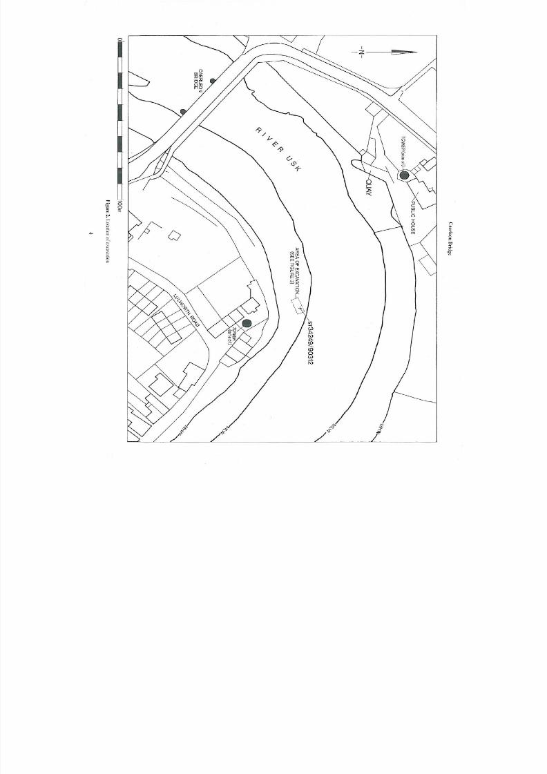
The flood defence development area is located on the south bank of the River Usk along
Isca and Lulworth Road, in Caerleon (Figure 1). The archaeological features and deposits
were identified at low tide, located upstream from the modern bridge on a south arching
bend in the river (NGR ST3424990312) (Figure 2).
Figure 1: Caerleon location map
3
8/14/2019 Caerleon Bridge
http://slidepdf.com/reader/full/caerleon-bridge 5/26
8/14/2019 Caerleon Bridge
http://slidepdf.com/reader/full/caerleon-bridge 6/26
Caerleon Bridge
1.4 Archaeological and historical background
The first known occupation at Caerleon relates to the foundation of the Roman fortress
( Isca) established cAD 75 as the base for the Second Augustan Legion ( Legio II Augusta);
occupation continued into the 4th
century (Boon 1972), although after the end of 3rd
century
it is not clear whether it was military or civilian in nature (Evans 2000, 170-3).The fortress was surrounded by a large civilian settlement or canabae. It extended to the
east and west of the fortress, even reaching across the river to the south to the area known
as Ultra-pontem in the Middle Ages. Isca Road is thought to have served as the main route
into the fortress from the earlier fortresses of Usk and Kingsholm (Gloucester), presumably
crossing the River Usk on the alignment of the via praetoria (Manning 2004, 178-204), a
short distance upstream from David Edwards’ 19 -century masonry bridge, which now
provides modern access to the town (Newman 2000, 136-45).
th
No evidence for the existence
of a Roman bridge has, as yet, been discovered. However the efficiency of the Roman
military system would demand that a serviceable crossing must have been in place.
There is some evidence for post-Roman occupation and burial areas in Caerleon (Evans2000, 170-3). Indeed, when Giraldus Cambrensis visited the site later in the medieval
period (AD 1188) he recorded that a Roman building within the fortress was still intact and
roofed. A motte and bailey castle was constructed by AD 1086 immediately to the south of
the fortress, presumably to guard the approaches from the direction of the Ultra-pontem
settlement along the former via praetoria, suggesting the continued importance of this
route into this period. A bridge over the River Usk, protected by the castle, is likely to have
existed at this time.
The exact extent of the castle and its defences are not clear, with only the remains of the
motte and a tower attached to the Hanbury Arms surviving. The large motte is comparable
in size to the motte inside Cardiff Castle and is presumed to have been erected by the thenLord of Caerleon Caradoc ap Gruffydd or his son Owain ap Caradoc (Davies 2004, 347;
Newman 2000, 142). William Marshal the Elder (died 1219) came into the possession of
Caerleon Castle in AD 1217 and added the circular tower to the bailey, which still survives
as part of the Hanbury Arms. St Cadoc’s church situated in the centre of Caerleon is almost
certainly an Early medieval ecclesiastical site (Evans 2003, 53). The medieval town plan
appears to have respected the Roman street plan with the four main roads into the town
positioned on the four cardinal points (Newman 2000, 136-45).
Although it is clear that some level of fortification of the south bank of the river occurred,
in the form of a medieval barbican tower protecting the presumed bridge head, the town
was established to the north of the castle and it is likely that the present street plan is
comparable to the medieval one. Certainly it was in place by the mid 18th century as it isdepicted on the earliest surviving plans (Thorpe 1752). Caerleon’s economy remained
strong throughout the post-medieval period, bolstered by its port it was an important town
until the rise of neighbouring Newport in the early 19th
century (Kennerly 1979).
5
8/14/2019 Caerleon Bridge
http://slidepdf.com/reader/full/caerleon-bridge 7/26
Caerleon Bridge
2 Methodology
In compliance with the excavation methodology, detailed in the project design (Lewis
2004), a significant quantity of overburden was removed mechanically using a toothless 2m
grading bucket, the timber features were then hand excavated to the lowest levels exposed
by the tide. A written and photographic record was made of all archaeological features anddeposits in accordance with the GGAT Manual of Excavation Recording Techniques.
Contexts were recorded using a single continuous numbering system and are summarised in
Appendix 1. Timber remains were recorded using a single continuous numbering system
and are summarised in Appendix 2. Context numbers are depicted in bold within the text,
whilst timber numbers are italicised , an asterisk (*001) indicates sample numbers. Plans
and sections were hand-drawn. All significant contexts and timbers were photographed
using a digital camera, and 35mm black and white and colour-slide film. The excavated
area was located in relation to published boundaries (OS grid).
All classes of finds have been retained, cleaned, and catalogued and remain in temporary
store until arrangements for final deposition are agreed, in line with the requirements of theInstitute of Field Archaeologists’ Standard and Guidance for the collection, documentation,
conservation and research of archaeological materials (2001). When substantial quantities
of modern material were recovered, an on-site policy of record and discard was
implemented.
The management of environmental recording and sampling followed the principles and
tenets laid down in English Heritage’s Guidelines for Environmental Archaeology,
published in 2002. All deposits with a high potential for the preservation of
palaeoenvironmental material were sampled, by column, bulk and other methods, for
possible subsequent analysis, in accordance with a sampling strategy overseen by a
specialist with appropriate expertise.
The project archive will be deposited with an appropriate receiving organisation, in
accordance with the UKIC and IFA Guidelines. This archive will comprise the site archive,
research archive, artefacts (excepting those that may be subject to the Treasure Act) and
ecofacts, subject to the agreement of the site owners. A copy of the archive index will be
deposited with the National Monuments Record, RCAHMW, Aberystwyth.
6
8/14/2019 Caerleon Bridge
http://slidepdf.com/reader/full/caerleon-bridge 8/26
Caerleon Bridge
3 Results
3.1 Introduction
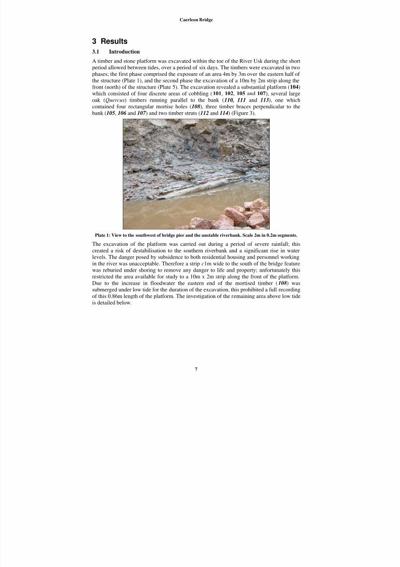
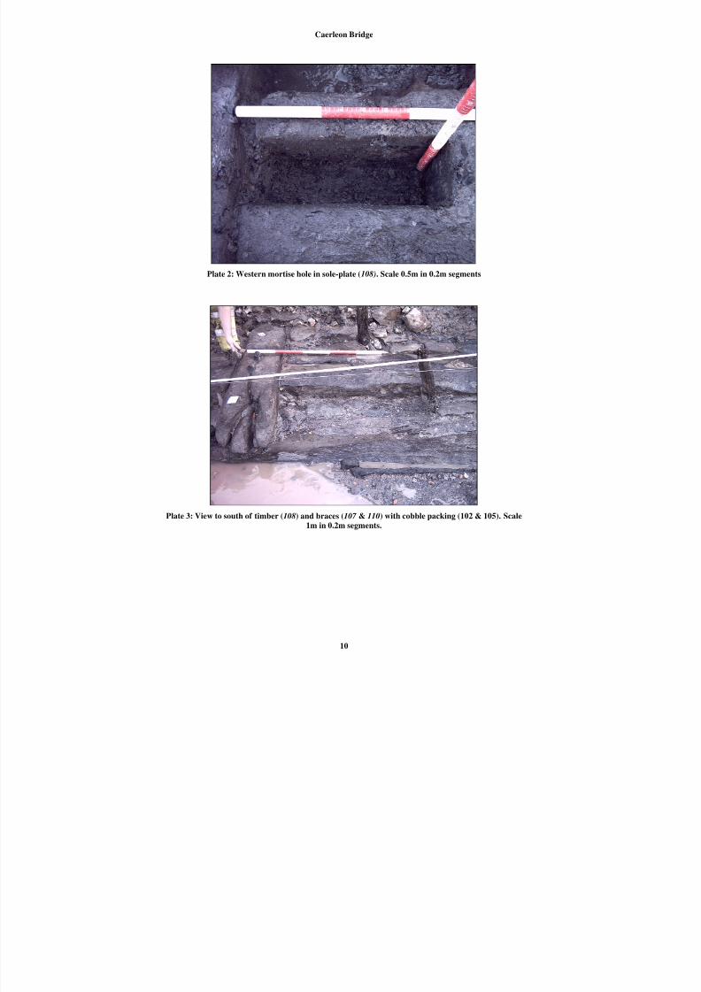
A timber and stone platform was excavated within the toe of the River Usk during the short
period allowed between tides, over a period of six days. The timbers were excavated in twophases; the first phase comprised the exposure of an area 4m by 3m over the eastern half of
the structure (Plate 1), and the second phase the excavation of a 10m by 2m strip along the
front (north) of the structure (Plate 5). The excavation revealed a substantial platform (104)
which consisted of four discrete areas of cobbling (101, 102, 105 and 107), several large
oak (Quercus) timbers running parallel to the bank (110, 111 and 113), one which
contained four rectangular mortise holes (108), three timber braces perpendicular to the
bank (105, 106 and 107 ) and two timber struts (112 and 114) (Figure 3).
Plate 1: View to the southwest of bridge pier and the unstable riverbank. Scale 2m in 0.2m segments.
The excavation of the platform was carried out during a period of severe rainfall; this
created a risk of destabilisation to the southern riverbank and a significant rise in water
levels. The danger posed by subsidence to both residential housing and personnel working
in the river was unacceptable. Therefore a strip c1m wide to the south of the bridge feature
was reburied under shoring to remove any danger to life and property; unfortunately this
restricted the area available for study to a 10m x 2m strip along the front of the platform.
Due to the increase in floodwater the eastern end of the mortised timber (108) was
submerged under low tide for the duration of the excavation, this prohibited a full recording
of this 0.86m length of the platform. The investigation of the remaining area above low tide
is detailed below.
7
8/14/2019 Caerleon Bridge
http://slidepdf.com/reader/full/caerleon-bridge 9/26
Caerleon Bridge
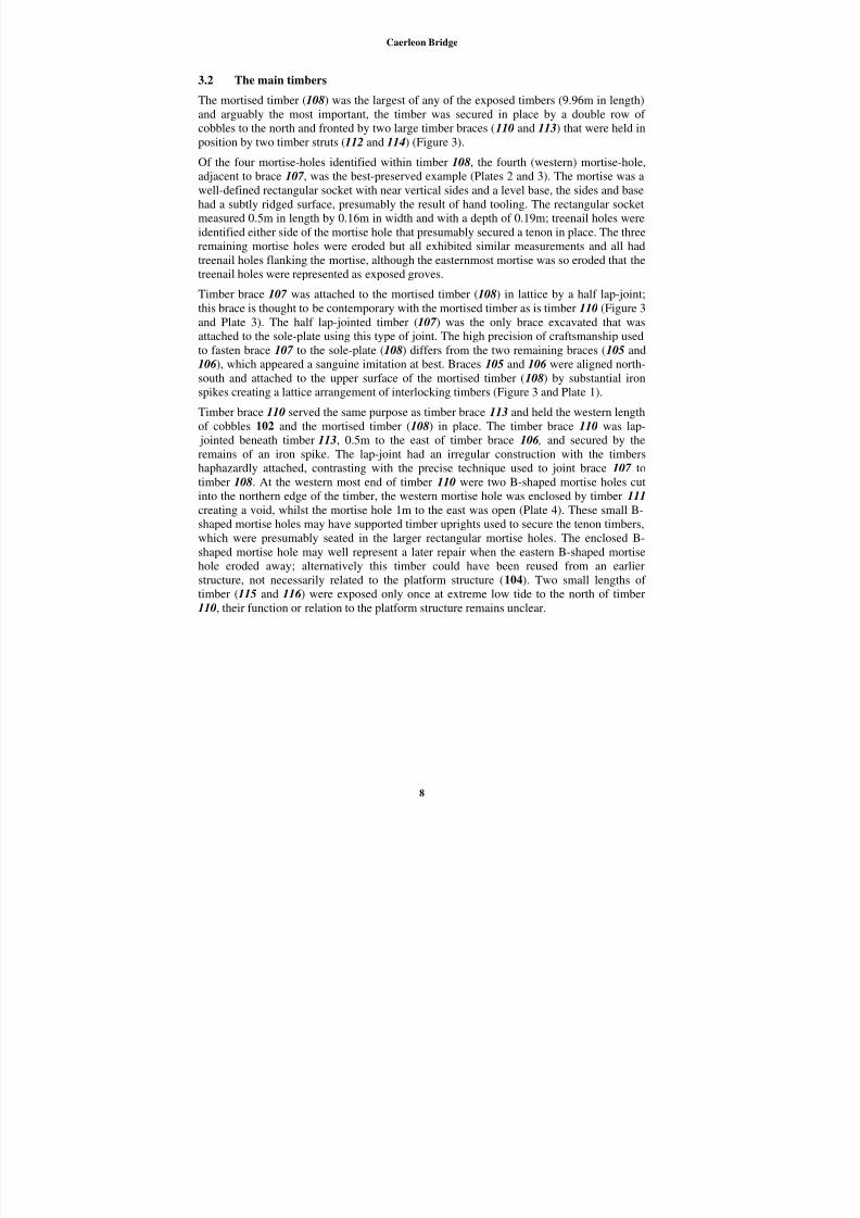
3.2 The main timbers
The mortised timber (108) was the largest of any of the exposed timbers (9.96m in length)
and arguably the most important, the timber was secured in place by a double row of
cobbles to the north and fronted by two large timber braces (110 and 113) that were held in
position by two timber struts (112 and 114) (Figure 3).
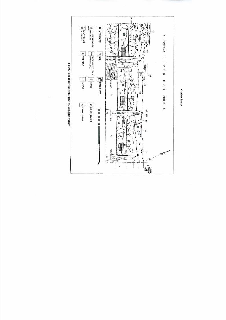
Of the four mortise-holes identified within timber 108, the fourth (western) mortise-hole,
adjacent to brace 107 , was the best-preserved example (Plates 2 and 3). The mortise was a
well-defined rectangular socket with near vertical sides and a level base, the sides and base
had a subtly ridged surface, presumably the result of hand tooling. The rectangular socket
measured 0.5m in length by 0.16m in width and with a depth of 0.19m; treenail holes were
identified either side of the mortise hole that presumably secured a tenon in place. The three
remaining mortise holes were eroded but all exhibited similar measurements and all had
treenail holes flanking the mortise, although the easternmost mortise was so eroded that the
treenail holes were represented as exposed groves.
Timber brace 107 was attached to the mortised timber (108) in lattice by a half lap-joint;
this brace is thought to be contemporary with the mortised timber as is timber 110 (Figure 3
and Plate 3). The half lap-jointed timber (107 ) was the only brace excavated that was
attached to the sole-plate using this type of joint. The high precision of craftsmanship used
to fasten brace 107 to the sole-plate (108) differs from the two remaining braces (105 and
106 ), which appeared a sanguine imitation at best. Braces 105 and 106 were aligned north-
south and attached to the upper surface of the mortised timber (108) by substantial iron
spikes creating a lattice arrangement of interlocking timbers (Figure 3 and Plate 1).
Timber brace 110 served the same purpose as timber brace 113 and held the western length
of cobbles 102 and the mortised timber (108) in place. The timber brace 110 was lap-
jointed beneath timber 113, 0.5m to the east of timber brace 106 , and secured by the
remains of an iron spike. The lap-joint had an irregular construction with the timbershaphazardly attached, contrasting with the precise technique used to joint brace 107 to
timber 108. At the western most end of timber 110 were two B-shaped mortise holes cut
into the northern edge of the timber, the western mortise hole was enclosed by timber 111
creating a void, whilst the mortise hole 1m to the east was open (Plate 4). These small B-
shaped mortise holes may have supported timber uprights used to secure the tenon timbers,
which were presumably seated in the larger rectangular mortise holes. The enclosed B-
shaped mortise hole may well represent a later repair when the eastern B-shaped mortise
hole eroded away; alternatively this timber could have been reused from an earlier
structure, not necessarily related to the platform structure (104). Two small lengths of
timber (115 and 116 ) were exposed only once at extreme low tide to the north of timber
110, their function or relation to the platform structure remains unclear.
8
8/14/2019 Caerleon Bridge
http://slidepdf.com/reader/full/caerleon-bridge 10/26
8/14/2019 Caerleon Bridge
http://slidepdf.com/reader/full/caerleon-bridge 11/26
Caerleon Bridge
Plate 2: Western mortise hole in sole-plate (108). Scale 0.5m in 0.2m segments
Plate 3: View to south of timber (108) and braces (107 & 110) with cobble packing (102 & 105). Scale
1m in 0.2m segments.
10
8/14/2019 Caerleon Bridge
http://slidepdf.com/reader/full/caerleon-bridge 12/26
Caerleon Bridge
Plate 4: B-shaped mortise hole (timber 110). Scale 1m in 0.2m segments. Plate 5: View of timber 10
sampling. Scale 1
11
8/14/2019 Caerleon Bridge
http://slidepdf.com/reader/full/caerleon-bridge 13/26
Caerleon Bridge
3.3 The platform
The excavation of a 12m² area of the riverbank exposed a large timber and cobble platform
(104) (Plate 1). A cobble surface (101) several courses in width, to the rear of the platform and
running parallel to the bank, was partially obscured by the baulk as were the unexcavated
(southern) ends of the timber braces 105 and 106 . The rear (south) of the mortised timber(108), within the latticework of timbers (see section 3.2), consisted of a tightly packed make-up
deposit of debris including brick, tile, glass, ceramics and iron objects dating from the 17 th
century to the 19th
century. The mortised timber (108), cobbles (102) and brace (113) deviated
from the horizontal by 0.22m at its eastern end creating a gently sloping profile. The
latticework of timber braces (105 and 106 ) and the cobbled surface (101) to the rear of the
platform appeared to have been positioned to offset this negative elevation creating a near level
profile with timber (107 ) and the western end of the mortised timber (108).
During the excavation of the carefully selected areas for dendrochronolgical sampling (*003-
*007), several areas were exposed below the depth of the mortised timber (108) (Plate 5,
hachured area Figure 3, and below *007, timber 110). The compacted make-up fill 103 was
removed to the east of timber 107 and south of the timber 108, exposing an additional cobbled
surface (107) that was also identified beneath timber 110. The cobbles differed in their form
and placement from those in the surfaces identified elsewhere (101, 102 and 105); these
cobbles were elongated rectangular slabs set vertically in the bank. Presumably this surface
(107) needed added depth to carry the weight of the platform timbers; ergo this structure is
arguably the oldest structural feature associated with the platform structure (104). The western
end of cobbled surface 102 and cobbled structure 105 were laid down securing the mortised
timber (108) and brace (107 ) in place over cobbles 107 (Figure 3).
A considerable build-up of clean alluvial silts (0.06m) were allowed to form over cobbled
feature 102 and beneath timber brace 107 indicating that the mortised timber (108), brace and
cobbles were exposed to the tidal movements of the River Usk for a significant period of time.A fragment of Roman local greyware was recovered from the clean alluvial deposit 106, with a
fine-combed decoration and black colour wash, this type of pot imitated contemporary Black
burnished vessels and was popular during the 1st
and 2nd
century AD. It is assumed that this
Roman pot sherd washed into the bridge structure during the accumulation of the alluvial silts
(106) over cobbled feature 102, as part of a later red earthenware jug belonging to the 17 th to
19th
centuries was also recovered from the same deposit.
12
8/14/2019 Caerleon Bridge
http://slidepdf.com/reader/full/caerleon-bridge 14/26
Caerleon Bridge
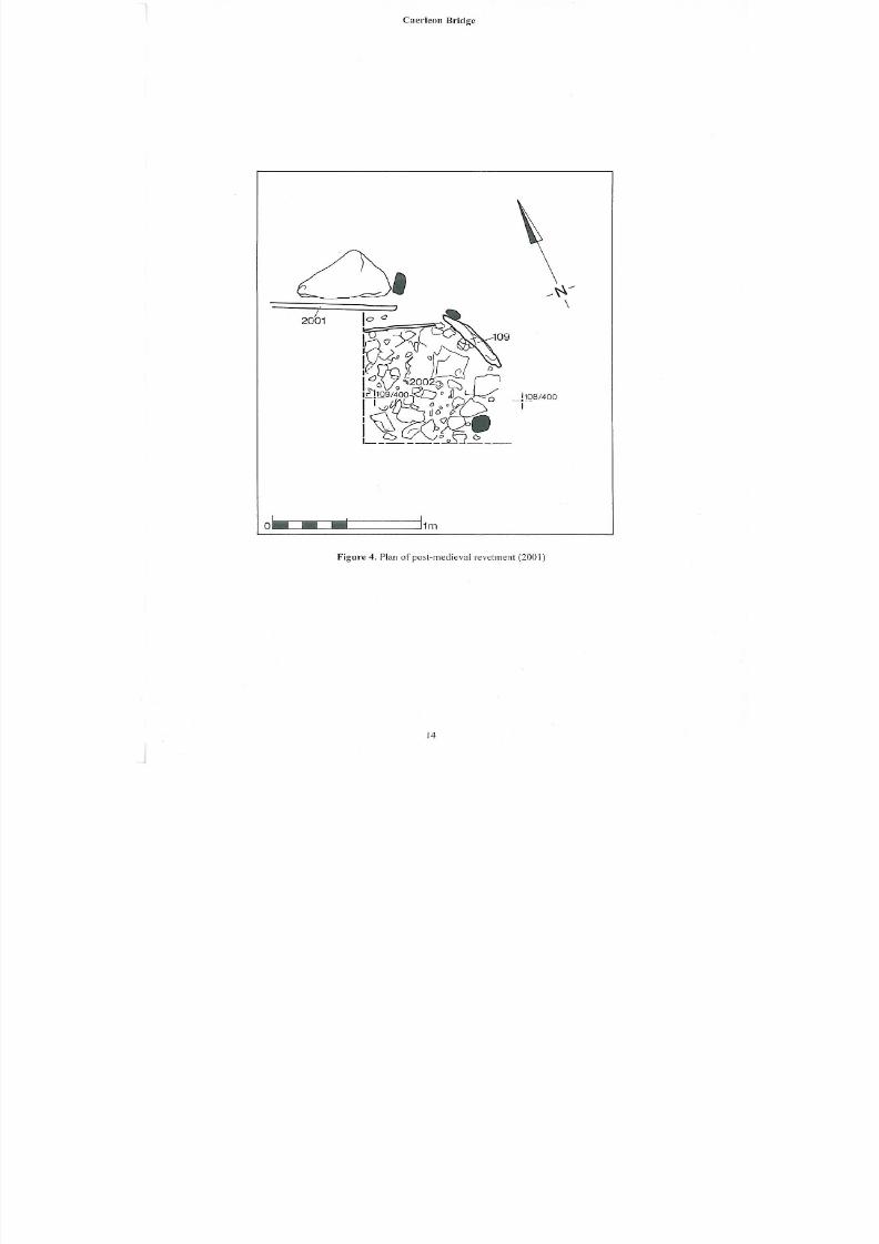
3.4 The revetment
Overlying the western end of the platform structure (104) was the remains of a later timber
revetment (2001), which contained a small rectangular metalled surface (2002), held within
two timber planks that were positioned on their edges supported by four upright posts and the
northern edge of timber 108 (Figure 4). The builders of this revetment structure appear to have
taken advantage of the platform to support their attempts to shore up the bank, indicating that a
substantial part of the structure (104) must have been exposed.
Of the four mortise holes identified in timber (108), the revetment overlaid the westernmost
and best-preserved example; for that reason the presumed upright timber tenon that fitted the
mortise must have been removed by this time. The fact that the mortise hole was reasonably
well preserved in comparison to the other three found within the mortised timber (108) would
suggest the revetment was constructed over the platform structure a short period after the
structure’s apparent demolition. Finds recovered from the unstratified deposit removed from
over the timber revetment included a George III 3rd issue halfpenny of 1799 and range of post-
18th
century ceramics and glass. The same timber revetment was recorded in numerous places
(1001 and 1002) up- and down-stream of the platform structure (104); the construction methodof timber slats or planks supported by roundwood stakes, positioned in steps up the riverbank,
from the toe of the river toward the top of the bank, would suggest that a significant program of
shoring was implemented some time late in the 18th
century or in the early 19th
century.
13
8/14/2019 Caerleon Bridge
http://slidepdf.com/reader/full/caerleon-bridge 15/26
8/14/2019 Caerleon Bridge
http://slidepdf.com/reader/full/caerleon-bridge 16/26
Caerleon Bridge
3.5 The finds by Steve Sell
Material from five contexts was examined. Unstratified finds formed the great majority of the
assemblage, and included a wide range of post-18th
century ceramics and glass. This
assemblage was subject to on-site selection. Diagnostic clay pipes gave an early to mid 19th
-
century date. One coin was recovered, a George III 3rd
AE issue halfpenny of 1799. A numberof copper or copper alloy (brass) fragments included horse furniture, parts of an oil-lamp, a
lock-plate, a cufflink, and fragments of tacks and pins. All are likely to be of similar date. One
sherd of medieval pottery was noted, from the lower wall of a glazed jug, to which a close date
cannot be ascribed.
From the base of context 106, recovered between cobbles 102, a fragment from the upper wall
of a Roman local greyware jar was recovered, with fine-combed decoration and black colour
wash in imitation of contemporary Black burnished vessels. This type of greyware is common
to South Wales and seems particularly popular during the first and second century AD.
The assemblage from context 103 was also selected; a date range from the 17th
to 19th
centuries
is indicated. Ceramics include local red earthenwares and North Devon gravel-tempered waresand cream-coloured earthenwares. This context also contained a number of fragments of
copper alloy, including a button, a dress-hook and three pins.
A similar date may be appropriate for material recovered from context 106, which included
part of a small jug in local red earthenware.
3.6 Summary of the dendrochronological analysis by Robert Howard
Cross-sectional slices were obtained from five different oak timbers, numbers 105, 106 , 107 ,
108 and 110 (Figure 3 and Plate 5). The widths of the annual growth rings of all five samples
were measured and analysed by dendrochronology. Unfortunately, despite exhaustive attempts,
no reliable cross-matching between any of the samples, or between samples and any reference
chronology could be found. All samples must therefore remain undated at the present time (for
the full dendrochronological report please refer to Appendix III).
15
8/14/2019 Caerleon Bridge
http://slidepdf.com/reader/full/caerleon-bridge 17/26
Caerleon Bridge
4 Discussion
The timber and cobble platform (104) excavated in the southern bank of the River Usk, at
Caerleon, represents the significant survival, in part, of a wooden bridge. This recognition is in
part due to the identification of timber 108 as a bridge sole-plate, a long timber set within a pier
supporting an upright trellis. Close parallels have been excavated at Monmouth (Maylan 1988,73) and documentary sources survive illustrating this type of bridge design (Coxe 1801, 359
and Grose 1784). The bridge pier appeared to have undergone several phases of construction
and repair. The timber sole-plate (108) and contemporary braces (107 and 110) appeared to be
associated with the first phase of the bridge construction, whilst the building method of lattice
braces, and associated artefacts, exposed along the eastern periphery of the structure (timbers
105, 106 , 113) would suggest a much later repair (Figure 3 and Plate 1).
Exactly when the first phase was constructed is difficult to ascertain but the construction
method of a sole-plate supporting a timber trellis has parallels with several regional examples
of the medieval period, most notably at Newport, Chepstow and Monmouth. The timber
precursor to the fortified stone bridge at Monmouth was excavated during the late 1980s aheadof flood alleviation work and had similarities to the remains exposed in Caerleon. A timber
sole-plate 8m in length supporting three timber uprights attached by mortise and tenon joints
was recorded beneath the 13th
-century stone bridge (Maylan 1988, 73). A medieval date for
the initial construction of the bridge at Caerleon is therefore not improbable.
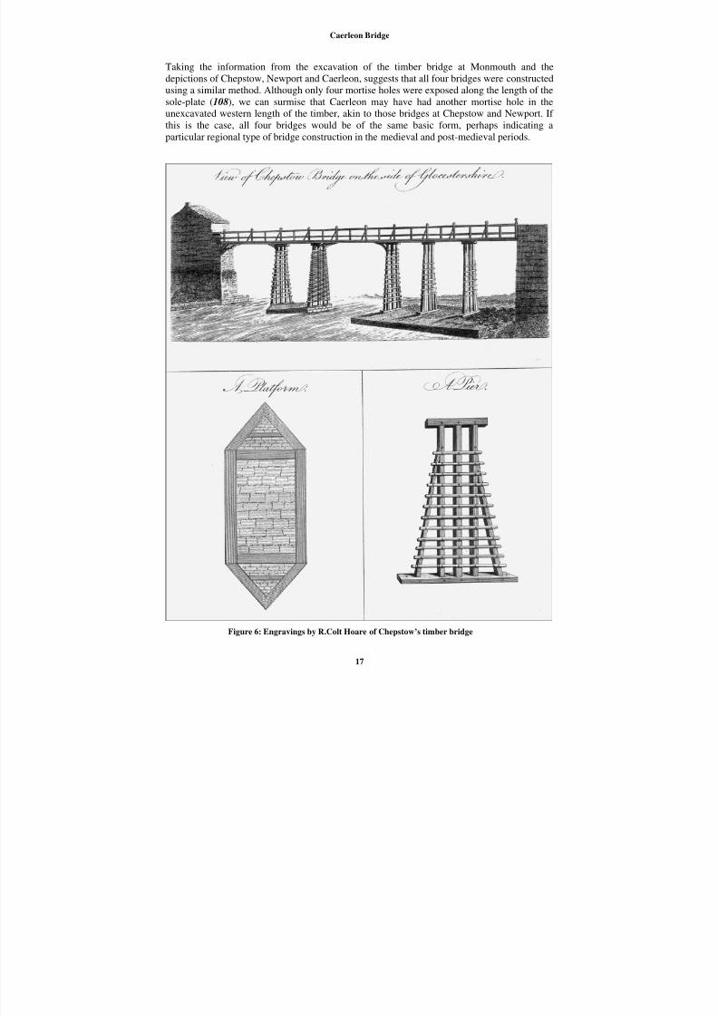
Close parallels with the bridge at Chepstow are also suggested from pictorial sources, although
this bridge was never excavated and we therefore have to rely on documentary evidence. In his
An Historical Tour in Monmouthshire (Coxe 1801, 359), Coxe noted the similarity in
construction between the bridges of Chepstow, Newport and Caerleon. He also included several
detailed engravings of the bridge at Chepstow that clearly depict a series of timber sole-plates
supporting a trellis arrangement of timbers, and the upper road surface (Coxe 1801, 360)
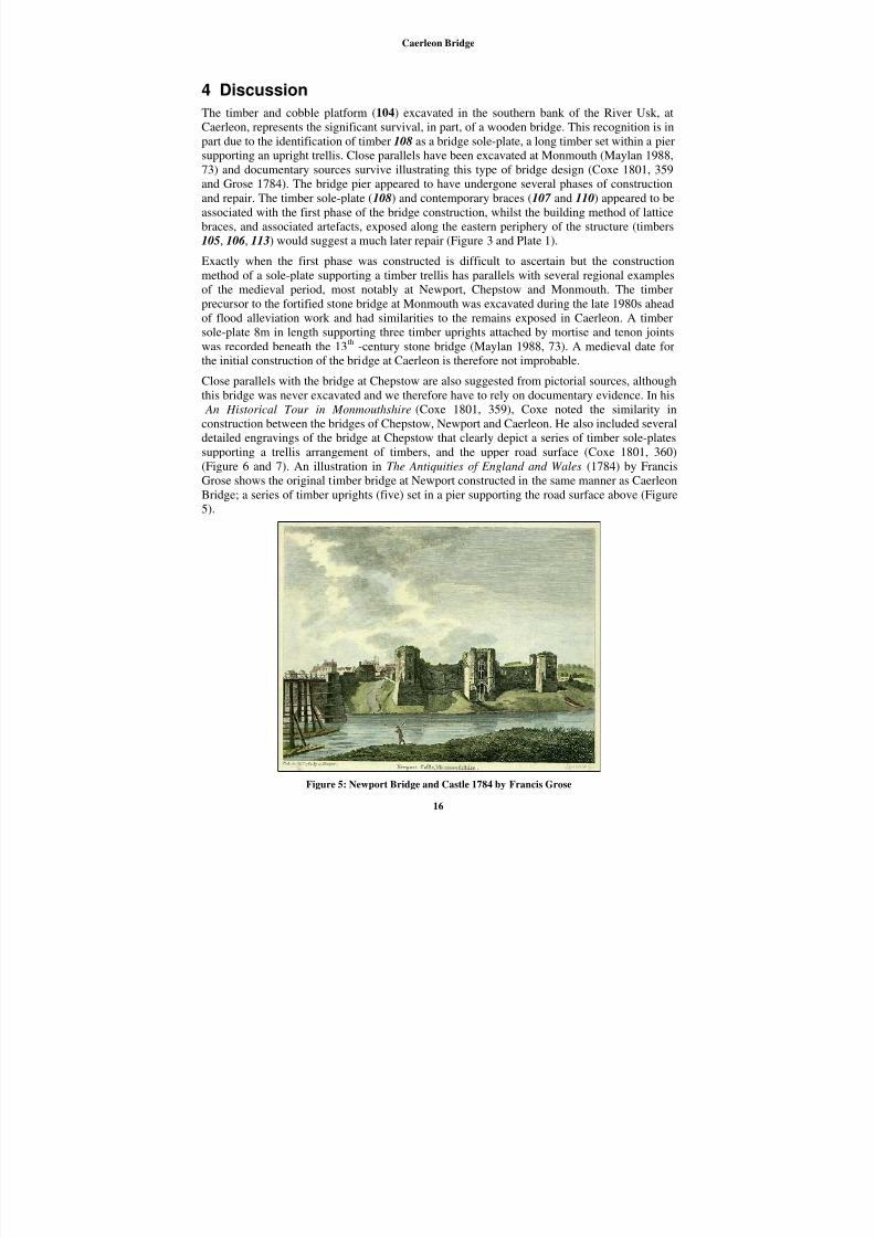
(Figure 6 and 7). An illustration in The Antiquities of England and Wales (1784) by Francis
Grose shows the original timber bridge at Newport constructed in the same manner as Caerleon
Bridge; a series of timber uprights (five) set in a pier supporting the road surface above (Figure
5).
Figure 5: Newport Bridge and Castle 1784 by Francis Grose
16
8/14/2019 Caerleon Bridge
http://slidepdf.com/reader/full/caerleon-bridge 18/26
Caerleon Bridge
Taking the information from the excavation of the timber bridge at Monmouth and the
depictions of Chepstow, Newport and Caerleon, suggests that all four bridges were constructed
using a similar method. Although only four mortise holes were exposed along the length of the
sole-plate (108), we can surmise that Caerleon may have had another mortise hole in the
unexcavated western length of the timber, akin to those bridges at Chepstow and Newport. If
this is the case, all four bridges would be of the same basic form, perhaps indicating aparticular regional type of bridge construction in the medieval and post-medieval periods.
Figure 6: Engravings by R.Colt Hoare of Chepstow’s timber bridge
17
8/14/2019 Caerleon Bridge
http://slidepdf.com/reader/full/caerleon-bridge 19/26
Caerleon Bridge
Although the date of the bridge at Caerleon cannot be definitely established from
dendrochronology, this may be the structure for which repairs are recorded in the documentary
sources. An Elizabethan statute (39 Eliz. c.23) promulgated in AD 1597 records that Caerleon
Bridge needed considerable repairs at that time and was passed to give the new County of
Monmouthshire powers to repair the bridge1.
“an Acte for the repairing of the Bridges of Newport and Carlion, in the County of
Monmouth.”
“having nothing to mainteine the same, is likewise of late fallen to great ruine and
decay, and is likely dayly to fall, to the great hinderance and hurt of a great
multitude of your Majesties subjects travailing into those parts.”
A catastrophic event during the late 18th
century appears to have ruined a substantial part of the
bridge structure. This event is indicated by a bill for the rebuilding of Caerleon Bridge recorded
in AD 1790 (1790 ref: 12818), and also in a claim by Coxe that part of the bridge was swept
away in a storm on 29th
October 1772, his description is as follows;
“The height of the water, at extraordinary tides, exceeds thirty feet, but though it
has never risen above the floor, yet the united body of a high tide, and the floods to
which the Usk is subject, have been known to carry away parts of the bridge. An
accident of this kind which happened on the 29th of October 1772, occasioned a
singular event, to which I should not have given credit, had it not been
authenticated by the most respectable testimony. As Mrs. Williams, wife of Mr.
Edward Williams, brazier, was returning from the village of Caerleon to the town,
at eleven o’clock at night, with a candle and lanthorn, the violence of the current
forced away four piers, and a considerable part of the bridge” (Coxe 1801, 101).
The loss of four piers would certainly need considerable repair and must have been completed
by the early 1790s when Coxe began his travels. He gives a good account of the bridge anddetails much of its construction and present state of repair;
“The wooden bridge over the Usk may be considered as similar to that erected by
the Romans; the frame is not unlike the carpentry of Caesar’s bridge over the
Rhine, which he has described in his Commentaries, and of which Stukeley has
given a plan, in the second volume of his Itinerarium Curiosum. The floor,
supported by ten lofty piers, is level, and divided by posts and rails into rooms or
beds of boards, each twelve feet in length; the apparently loose and disjointed state
of the planks, and the clattering noise which they make, under the pressure of a
heavy weight, have not unfrequently occasioned alarm to those who are unused to
them; Some travellers, from a superficial view of the structure, have asserted that the planks are placed loose, to admit the tide through their interstices when it rises
above the bridge, and which would, if they were fixed, force them from the frame
and carry them away. But in fact the tide has never been known to rise above the
bridge, nor was the flooring constructed to obviate this inconvenience. Formerly
the planks were fastened at each extremity with iron nails; but the wood being
liable to split, and the nails frequently forced up, by the elastic agitation of the
beams, under the pressure of heavy carriages, the planks were secured from rising
by horizontal rails, fastened to the posts, and prevented from flipping sideways, by
a peg at each end, within the rail” (Coxe 1801, 100-101).
1 Special thanks are due to Robert Trett who kindly researched this particular source.
18
8/14/2019 Caerleon Bridge
http://slidepdf.com/reader/full/caerleon-bridge 20/26
Caerleon Bridge
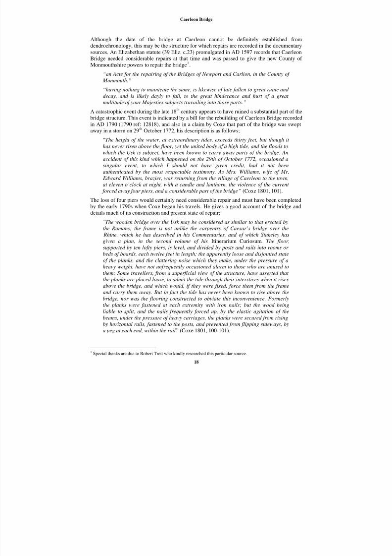
Figure 7: Engraving by R.Colt Hoare of Caerleon Bridge
The general rickety nature of the bridge at Caerleon seems to reflect a general poor state of
repair. Furthermore a notice by Morgan, Clerk to the Peace in May of 1789 and published inThe Gloucester Journal argues for the building of a brand new stone bridge instead of another
replacement in timber if “…there is reason to apprehend it (the bridge) may be so damaged
again if repaired with timber as usual. It is therefore thought expedient that a stone bridge
should substituted and as soon as convenient may be erected in place of the old one”. The
Clerk to the Peace goes on to admit the “…heavy demand which has for many years been made
of the said county (Monmouthshire) for the repair of the several wooden bridges within the
same...(county)”, this is a reference to the rebuilding of the timber bridge at Newport into stone
(Nichols 1977, 130).
The survival of any part of the original Roman bridge at Caerleon is doubtful, although the
later medieval bridge appears to have kept the same alignment. A medieval date for the earliestpart of the bridge (sole-plate 108) is possible on typological grounds, given the evidence from
Monmouth. The evidence from the Elizabethan statute indicated that by the end of the 16 th
century Caerleon Bridge was in an advanced state of decay; it is therefore not unreasonable to
suggest the structure may have been several hundred years old by that point. Without definite
dating evidence it will remain difficult to determine whether the original medieval bridge was
regularly repaired when parts of the structure became unusable or whether the bridge was
entirely replaced in the post-medieval period. The repairs listed in the 1790 bill, and the
disaster described by Coxe during the latter part of the 18th
century, advocates a continuing
cycle of restoration. Indeed the fact that the bridge was repaired after the damage caused in
1772 indicates the authorities were willing to carry out major repairs in partial rebuilding,
rather than complete replacement. The public notice issued by the Clerk to the Peace in 1789demonstrates the importance of the bridge and consequently the need to replace it finally in
stone. The construction of the stone bridge by David Edwards (1806-12) a short distance
downstream seems to have permanently ended the sequence of timber renewal (Newman 2000,
142).
19
8/14/2019 Caerleon Bridge
http://slidepdf.com/reader/full/caerleon-bridge 21/26
8/14/2019 Caerleon Bridge
http://slidepdf.com/reader/full/caerleon-bridge 22/26
Caerleon Bridge
Appendix I
Inventory of contexts (excluding timbers)
Context Location Type Description Period
100 U/S U/S General unstratified material from around 104 Multi-period
101 104 Structure Cobbled surface to the south (rear) of 104 Post-medieval
102 104 Structure Cobbled surface to the north (front) of 104 Post-medieval
103 104 Deposit Make-up between timber soleplate 108 and lattice
timbers 105, 106 and 107 .
Post-medieval
104 104 Structure Timber and cobble constructed bridge pier. Post-medieval
105 104 Structure Cobbled surface to the rear (south) and abutting
timber soleplate 108.
Post-medieval
106 104 Deposit Clean alluvial deposit overlying cobbled surface
102.
Post-medieval
107 104 Structure Cobbled structure beneath bridge pier 104. Post-medieval
1001 1001 Structure Timber revetment. Post-medieval
1002 1002 Structure Timber revetment Post-medieval
2000 2001 Structure Worked and reused timber overlying bridge
timber 108, connecting 2001 with 104.
Post-medieval
2001 2001 Structure Timber revetment adjacent to west end of bridge
structure 104.
Post-medieval
2002 2001 Structure Timber revetment retaining a metalled surface
adjacent to west end of bridge structure 104.
Post-medieval
21
8/14/2019 Caerleon Bridge
http://slidepdf.com/reader/full/caerleon-bridge 23/26
Caerleon Bridge
Appendix II
Inventory of timbers
Wood
number
Context Date
lifted
Date
sampled
Description Species Period
101 U/S 23/08/04 - Unstratified worked timber depositedon riverbank west of bridge structure
104.
Unknown Post-medieval
102 U/S 23/08/04 - Substantial (unstratified) worked
timber deposited on riverbank west
of bridge structure 104.
Unknown Post-
medieval
103 2000 16/09/04 - Worked and reused timber overlying
bridge timber 108, connecting 2001
with 104.
Unknown Post-
medieval
104 2001 16/09/04 - Worked timber plank apart of
revetment 2001.
Unknown Post-
medieval
105 104 - 21/09/04 Roundwood brace attached to sole-
plate (108).
Oak
Quercus
Post-
medieval
106 104 - 21/09/04 Roundwood brace attached to sole-plate (108).
Oak Quercus
Post-medieval
107 104 - 21/09/04 Square brace jointed to and
contemporary with sole-plate (108).
Oak
Quercus
Medieval/
Post-
medieval
108 104 - 21/09/04 Timber sole-plate with four mortise
holes.
Oak
Quercus
Medieval/
Post-
medieval
109 2001 20/09/04 - Horizontal roundwood associated
with revetment 2001.
Unknown Post-
medieval
110 104 - 21/09/04 Horizontal timber retaining bridge
structure 104, brace contemporary
with sole-plate (108).
Oak
Quercus
Post-
medieval
111 104 - - Timber attached to 110 enclosing a
B-shaped mortise hole.
Unknown Post-
medieval
112 104 - - Squared roundwood stake retaining
timber 110.
Unknown Post-
medieval
113 104 - - Horizontal timber brace retaining
bridge structure 104, contemporary
with timbers 105 and 106 .
Unknown Post-
medieval
114 104 - - Squared (rectangular) roundwood
stake retaining timber 113.
Unknown Post-
medieval
115 104 - - A slim elongated plank situated
below maximum low tide, timber
lower in elevation than 110.
Unknown Post-
medieval
116 104 - - A slim elongated plank situatedbelow maximum low tide, timber
lower in elevation than 110.
Unknown Post-medieval
22
8/14/2019 Caerleon Bridge
http://slidepdf.com/reader/full/caerleon-bridge 24/26
Caerleon Bridge
Appendix III
Dendrochronological report
by Robert Howard
Introduction
In the summer of 2004 works were undertaken to enhance flood and erosion control measures
on the south bank of the River Usk at Caerleon in South Wales, about 10 river miles above its
junction with the Bristol Channel. During these works, as the bank was reformed by
mechanical diggers, a riverside timber structure was uncovered. This was represented by two
horizontal beams, both running parallel with the bank and river, and three horizontal timbers
running into the bank, at right angles to the river. These three timbers were jointed in to the
innermost timber parallel to the bank and river. The timbers were normally covered by water
and exposure only occurred during the lower stages of the tidal cycle.
The site was observed, excavated, and recorded by members of The Glamorgan-Gwent
Archaeological Trust Ltd, of Swansea. Although there was considerable archaeologicalmaterial recovered during the period of excavation, it was of a very mixed nature, initially
appearing to be mainly of post-medieval to 19th
century date, with little specific content that
might be used to reliably fix the timber structure in a dated context. It was further believed, on
the basis of stratigraphical evidence and the inter-relationship of the timbers, that more than
one phase of felling or use might be represented within the structure; the three timbers at right
angles to the river, and innermost parallel timber represented one phase, the outer-most timber
parallel to the river represented another phase.
On the basis of other evidence, in the form of an illustration dated 1800, and a map of 1901
showing the ‘site of an ancient crossing’ of the river at this point, and by comparison of the
structure with other known examples, it is believed that the timbers represent the remains of a
bridge pier. This early bridge was damaged by a storm flood in 1772 and replaced by thepresent stone one in 1812.
Sampling
Sampling and analysis by tree-ring dating of the timbers were commissioned by Richard Lewis
of Glamorgan-Gwent Archaeological Trust Ltd, the purpose of this being to establish the date
of the timbers and a context for the structure as a whole. After an examination of the structure,
and in conjunction with the sampling brief, five different oak timbers were sampled, the
samples being taken as 3-5 cm thick cross-sectional slices of the timbers using a chainsaw.
Each sample was given the code CAE-R (for Caerleon) and numbered 01-05; the positions of
the samples are marked on figure 3. Details of the samples are given in Table 1.
Tree-ring dating
Tree-ring dating relies on a few simple, but quite fundamental, principals. Firstly, as is
commonly known, trees (particularly oak trees, the most frequently used building timber in
England) grow by adding one, and only one, growth-ring to their circumference each, and
every, year. Each new annual growth-ring is added to the outside of the previous year’s growth
just below the bark. The width of this annual growth-ring is largely, though not exclusively,
determined by the weather conditions during the growth period (roughly March-September). In
general, good conditions produce wider rings and poor conditions produce narrower rings.
Thus, over the lifetime of a tree, the annual growth-rings display a climatically influenced
pattern. Furthermore, and importantly, all trees growing in the same area at the same time will
be influenced by the same growing conditions and the annual growth-rings of all of them will
respond in a similar, though not identical, way.
23
8/14/2019 Caerleon Bridge
http://slidepdf.com/reader/full/caerleon-bridge 25/26
Caerleon Bridge
Secondly, because the weather over any number of consecutive years is unique, so too is the
growth-ring pattern of the tree for that period. The pattern of a short period of growth, 20, 30 or
even 40 consecutive years, might conceivably be repeated two or even three times in the last
one thousand years. A short pattern might also be repeated at different time periods in different
parts of the country because of differences in regional micro-climates. It is less likely,
however, that such problems would occur with the pattern of a longer period of growth, that is,anything in excess of 54 years or so. In essence, a short period of growth, anything less than 54
rings, is not reliable, and the longer the period of time under comparison the better.
The third principal of tree-ring dating is that, until the early to mid-19th
century, builders of
timber-framed houses usually obtained all the wood needed for a given structure by felling the
necessary trees in a single operation from one patch of woodland, or from closely adjacent
woods. Furthermore, and contrary to popular belief, the timber was used “green” and without
seasoning, and there was very little long-term storage as in timber-yards of today. This fact has
been well established from a number of studies where tree-ring dating has been undertaken in
conjunction with documentary studies. Thus, establishing the felling date for a group of
timbers gives a very precise indication of the date of their use in a building.Tree-ring dating relies on obtaining the growth pattern of trees from sample timbers of
unknown date by measuring the width of the annual growth-rings. This is done to a tolerance
of 1/100 of a millimetre. The growth patterns of these samples of unknown date are then
compared with a series of reference patterns or chronologies, the date of each ring of which is
known. When the growth-ring sequence of a sample “cross-matches” repeatedly at the same
date span against a series of different relevant reference chronologies the sample can be said to
be dated. The degree of cross-matching, which is the measure of similarity between sample and
reference, is denoted by a “t-value”; the higher the value the greater the similarity. The greater
the similarity the greater is the probability that the patterns of samples and references have
been produced by growing under the same conditions at the same time. The statistically
accepted fully reliable minimum t-value is 3.5.
However, rather than attempt to date each sample individually it is usual to first compare all
the samples from a single building, or phases of a building, with one another, and attempt to
cross-match each one with all the others from the same phase or building. When samples from
the same phase do cross-match with each other they are combined at their matching positions
to form what is known as a “site chronology”. As with any set of data, this has the effect of
reducing the anomalies of any one individual (brought about in the case of tree-rings by some
non-climatic influence) and enhances the overall climatic signal. As stated above, it is the
climate that gives the growth pattern its distinctive pattern. The greater the number of samples
in a site chronology the greater is the climatic signal of the group and the weaker is the non-
climatic input of any one individual.
Furthermore, combining samples in this way to make a site chronology usually has the effect of
increasing the time-span that is under comparison. As also mentioned above, the longer the
period of growth under consideration, the greater the certainty of the cross-match. Any site
chronology with less than about 55 rings is generally too short for satisfactory analysis.
Analysis
In the case of the material from Caerleon, being semi-waterlogged, each of the five slices
obtained was firstly prepared by freezing. Once frozen the cross-sectional slices were reduced
to radial wedges. The surfaces of the wedges were then prepared using scalpels to clearly
reveal the annual growth rings, the widths of these rings on all five samples then being
measured.
24
8/14/2019 Caerleon Bridge
http://slidepdf.com/reader/full/caerleon-bridge 26/26
Caerleon Bridge
The data of these measurements were then compared with each other in the standard way as
described above. There was, however, no reliable or satisfactory cross-matching between any
of the individual samples. Each sample was then compared individually with a full and
extensive range of reference chronologies for oak, with material held at the Nottingham and
other Laboratories being used. Again, there was no reliable cross-matching between any
sample and any reference chronology. All five samples must, therefore, remain undated. Interpretation and conclusion
Analysis by dendrochronology has been unable to cross-match any one sample with any of the
other four samples from this site, nor has it been possible to reliably date any of the samples
individually by comparison with the available reference chronologies.
The lack of cross-matching and dating may in part be due to the relatively small number of
samples available and obtained. The usual minimum requirement from a single phase structure
is in the range 6-10 samples. In this case only five samples could be obtained, one of which,
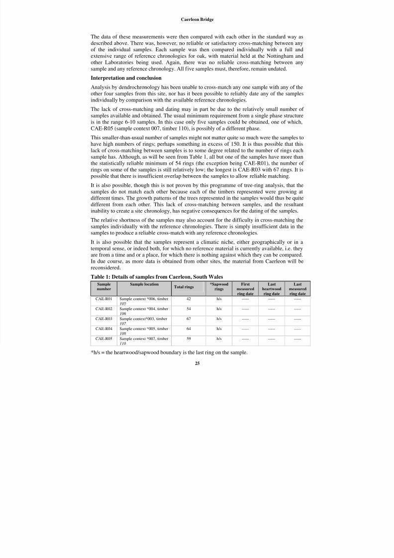
CAE-R05 (sample context 007, timber 110), is possibly of a different phase.
This smaller-than-usual number of samples might not matter quite so much were the samples tohave high numbers of rings; perhaps something in excess of 150. It is thus possible that this
lack of cross-matching between samples is to some degree related to the number of rings each
sample has. Although, as will be seen from Table 1, all but one of the samples have more than
the statistically reliable minimum of 54 rings (the exception being CAE-R01), the number of
rings on some of the samples is still relatively low; the longest is CAE-R03 with 67 rings. It is
possible that there is insufficient overlap between the samples to allow reliable matching.
It is also possible, though this is not proven by this programme of tree-ring analysis, that the
samples do not match each other because each of the timbers represented were growing at
different times. The growth patterns of the trees represented in the samples would thus be quite
different from each other. This lack of cross-matching between samples, and the resultantinability to create a site chronology, has negative consequences for the dating of the samples.
The relative shortness of the samples may also account for the difficulty in cross-matching the
samples individually with the reference chronologies. There is simply insufficient data in the
samples to produce a reliable cross-match with any reference chronologies.
It is also possible that the samples represent a climatic niche, either geographically or in a
temporal sense, or indeed both, for which no reference material is currently available, i.e. they
are from a time and or a place, for which there is nothing against which they can be compared.
In due course, as more data is obtained from other sites, the material from Caerleon will be
reconsidered.
Table 1: Details of samples from Caerleon, South WalesSample
number
Sample locationTotal rings
*Sapwood
rings
First
measured
ring date
Last
heartwood
ring date
Last
measured
ring date
CAE-R01 Sample context *006, timber
105
42 h/s ----- ----- -----
CAE-R02 Sample context *004, timber
106
54 h/s ----- ----- -----
CAE-R03 Sample context*003, timber
107
67 h/s ----- ----- -----
CAE-R04 Sample context *005, timber
108
64 h/s ----- ----- -----
CAE-R05 Sample context *007, timber
110
59 h/s ----- ----- -----
*h/s = the heartwood/sapwood boundary is the last ring on the sample.