Embed Size (px)
Citation preview
Business Plan for Orthoimagery in North Carolina
Statewide Mapping Advisory Committee
Working Group for Orthophotography Planning
October 2010
North Carolina
Geographic Information Coordinating Council

(blank page)
Business Plan for Orthoimagery in North Carolina
Statewide Mapping Advisory Committee
Working Group for Orthophotography Planning
Executive Summary
Digital aerial imagery is the most fundamental dataset for use with geographic information systems in local, state, and federal government and in numerous private and non-profit organizations. The NC Geographic Information Coordinating Council adopted statements and resolutions in 2003 and 2005 that called for a sustainable program for keeping high resolution statewide orthoimagery (also called orthophotography) current and accessible. Then, the General Assembly recommended a statewide imagery program as stated in Recommendations 13 through 17 in the State Geographic Information /Consolidation Implementation Plan, as directed by Session Law 2008-0107 Section 6.13, December 2008. In response, the Statewide Mapping Advisory Committee (SMAC) developed this North Carolina Orthoimagery Business Plan to support the coordinated acquisition of a seamless statewide imagery dataset of standardized quality, resolution, age, and format. Orthoimagery benefits a wide range of users of geospatial data, including private industry, public agencies, nongovernmental organizations, citizens, and educational institutions. Benefit measures include (a) saving time in locating and responding to emergencies, (b) saving time in informing public decisions, (c) avoiding the cost of erroneous information from out-of-date imagery and map features, and (d) saving time in handling, storing, retrieving, displaying, and archiving aerial imagery. In terms of business requirements, orthoimagery is the ultimate base map, recognizable to an every growing audience and suitable for reference and analysis to derive and enhance geospatial datasets. Orthoimagery in North Carolina adds value to three primary business uses: visual reference, data creation and maintenance, and image analysis. Data requirements focus on current technology and best practices that satisfy NC specifications for quality and accuracy as adopted in “North Carolina Technical Specifications for Digital Orthophoto Base Mapping” http://www.secretary.state.nc.us/land/. For the statewide project in 2010, the data requirements were orthoimagery produced in 5,000 by 5,000-foot tiles with ground resolution of 6 inches, amounting to 100,000,000 pixels per tile. Format is true color (3-band) in GeoTIFF format. The Coordinate Reference System is NC State Plane Coordinate System, NAD 1983 (NSRS 2007) Datum, with units of US Survey feet. Tiles have unique names and use a new naming convention (32 characters). The primary functional requirement for orthoimagery is to be readily available, free of charge, to local government operations including 911 and to a wide range of private and public users for visual reference, geospatial reference, and image analysis. Statewide orthoimagery should enable data discovery, data viewing, and data download.
Business Plan for Orthoimagery October 2010
2
A statewide project necessarily has costs related to consistency, quality, completeness, maintenance of infrastructure for positional reference, data management, and public access to information. Considering costs for a statewide program after 2010, a total cost on the order of $250 per square mile or less (or about $12 million) would appear to be achievable for all cost components including geodetic services, program management and data access. To achieve the goals of the Geographic Information Coordinating Council regarding imagery for the state, the SMAC recommends a collaborative approach to future projects to take advantage of experience and expertise across several organizations. As a prime example, the following approach was used in the statewide project in 2010.
• Overall program management was the responsibility of CGIA, staff to the GICC, to take advantage of CGIA’s project management experience and its capabilities to apply the coordination structure of the GICC and its committees and working groups to the statewide orthoimagery planning and implementation.
• Management of imagery acquisition, processing, and visual quality control was the responsibility of the Geospatial and Technology Management Office (GTM) to take advantage of large project management experience, imagery expertise, and data management experience.
• Management of geodetic control and horizontal quality control and related equipment was the responsibility of the NC Geodetic Survey to utilize experience managing and performing quality control in the field, maintaining datasets for control, and managing a statewide network of reference stations. This was in collaboration with GTM for efficient workflow.
• Public access to imagery (map services, data download, and related methods) and distribution of imagery products is being managed through NC OneMap by CGIA. In addition, CGIA is providing outreach in the form of presentations at conferences and other public events and website updates.
• Standard specifications for digital orthoimagery were updated in 2009 and are managed by the Land Records Management Section in the Secretary of State’s Office.
Funding for a statewide orthoimagery program after 2010 depends on budgeting, planning, negotiating, and factors that may not be apparent in 2010. As a framework, the recommended funding approach for the statewide program (including imagery acquisition, data access, program management and investment in geodetic control) is to work with the following groups to obtain funding that will support the recommendations contained in this plan:
1. Statewide organizations, including the NC 911 Board on behalf of local operations, and state departments that apply geospatial data to business processes. Specific amounts depend on project locations in relation to state program requirements, restrictions, timing and budgets.
2. Federal organizations, including cooperative agreements led by the National Geospatial Program. Funding from federal organizations depends on project locations, federal program initiatives and requirements, availability of funds, and limitations based on location and purpose.
3. Local governments. Specific amounts depend on project locations in relation to local program requirements and availability of funds.
Business Plan for Orthoimagery October 2010
3
4. Private organizations, including electric power utilities. In partnership with public entities, private organizations are potential sources for cost-share in selected counties where those organizations have business requirements for current high resolution imagery.
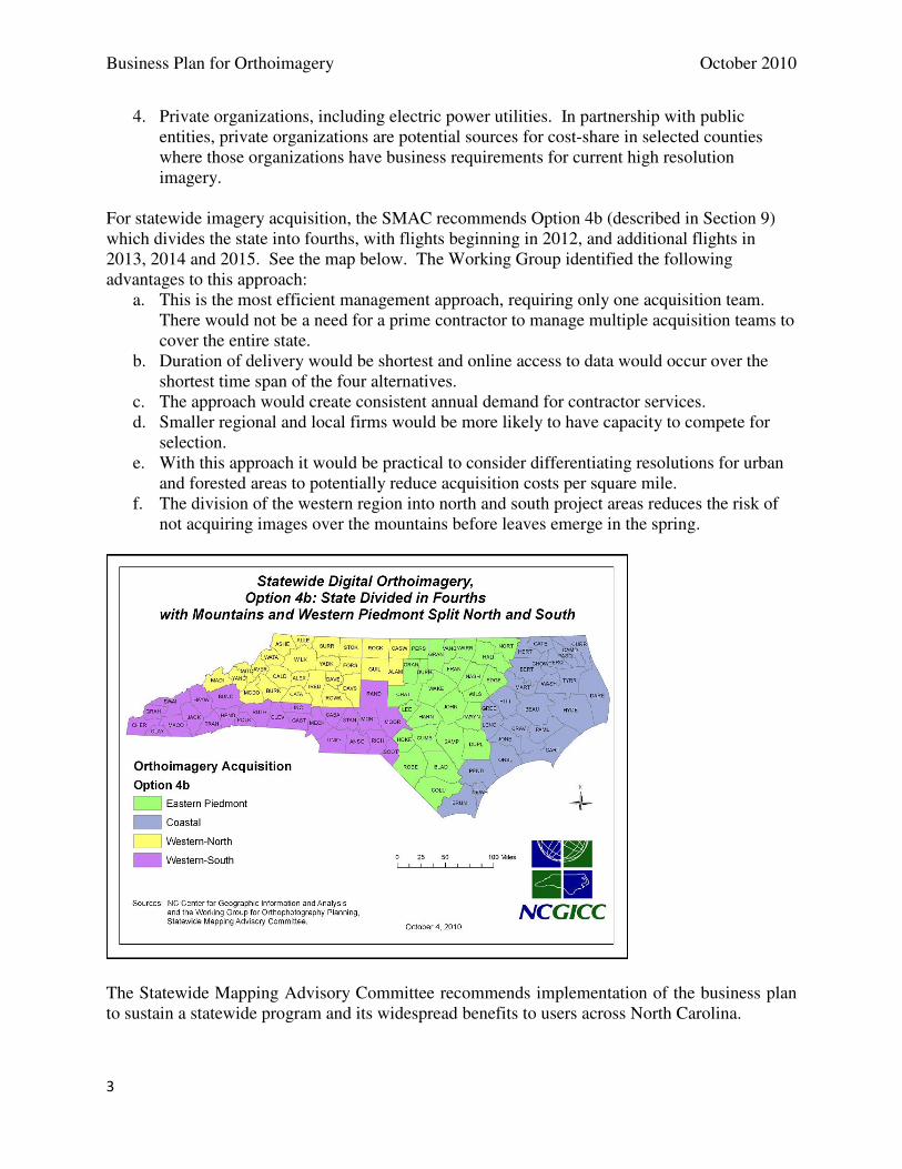
For statewide imagery acquisition, the SMAC recommends Option 4b (described in Section 9) which divides the state into fourths, with flights beginning in 2012, and additional flights in 2013, 2014 and 2015. See the map below. The Working Group identified the following advantages to this approach:
a. This is the most efficient management approach, requiring only one acquisition team. There would not be a need for a prime contractor to manage multiple acquisition teams to cover the entire state.
b. Duration of delivery would be shortest and online access to data would occur over the shortest time span of the four alternatives.
c. The approach would create consistent annual demand for contractor services. d. Smaller regional and local firms would be more likely to have capacity to compete for
selection. e. With this approach it would be practical to consider differentiating resolutions for urban
and forested areas to potentially reduce acquisition costs per square mile. f. The division of the western region into north and south project areas reduces the risk of
not acquiring images over the mountains before leaves emerge in the spring.
The Statewide Mapping Advisory Committee recommends implementation of the business plan to sustain a statewide program and its widespread benefits to users across North Carolina.

Business Plan for Orthoimagery October 2010
4
(blank page)
Business Plan for Orthoimagery October 2010
5
Contents Introduction .................................................................................................................................................. 7
1. Background ............................................................................................................................................... 8
2. Purpose ................................................................................................................................................... 15
3. Program Goals ......................................................................................................................................... 16
4. Program Benefits.................................................................................................................................... 17
A. Framework for Benefits ...................................................................................................................... 17
B. Benefits in North Carolina .................................................................................................................. 18
5. Requirements ......................................................................................................................................... 22
A. Business Requirements ...................................................................................................................... 22
B. Data Requirements ............................................................................................................................ 23
C. Functional Requirements ................................................................................................................... 25
6. Program Costs ........................................................................................................................................ 28
7. Organizational Approach ....................................................................................................................... 31
A. Organizational Structure .................................................................................................................... 31
B. Organizational Structure Detail ......................................................................................................... 32
1. QBS contracting .............................................................................................................................. 32
2. Project tasks .................................................................................................................................... 34
2.1. Standards .................................................................................................................................... 34
2.2. Geodetic control ......................................................................................................................... 36
2.3. Imagery acquisition, processing, QA/QC, and final product delivery ......................................... 37
2.4. Horizontal QA/QC ....................................................................................................................... 37
2.5. Data storage and user access to imagery ................................................................................... 38
2.6. Outreach to users........................................................................................................................ 38
Business Plan for Orthoimagery October 2010
6
3. Technical support ............................................................................................................................ 38
8. Project Funding ...................................................................................................................................... 39
A. Project funding approaches ............................................................................................................ 39
B. Investment in accuracy ..................................................................................................................... 40
C. Project funding sources .................................................................................................................. 40
D. Recommended funding approach for future projects ....................................................................... 41
9. Implementation Plan .............................................................................................................................. 43
A. Optional Approaches to Imagery Acquisition for the Statewide Program ........................................ 43
B. User Requirements and Benefits in the Context of Funding Sources ................................................ 49
C. Recommendations for Implementation of Future Projects ................................................................ 50
D. Risks and Dependencies .................................................................................................................... 51
10. APPENDICES ......................................................................................................................................... 52
Business Plan for Orthoimagery October 2010
7
Introduction
The North Carolina Orthoimagery Business Plan was developed to support the coordinated acquisition of statewide orthoimagery at scheduled intervals in order to replace the county-based acquisition system, which resulted in a patchwork collection of county imagery sets of varying quality, resolution, age, and datum, with a seamless statewide imagery dataset of standardized quality, resolution, age (within the same collection interval), and datum. The business plan’s goals are to establish a sustainable program for keeping high resolution statewide orthoimagery current and accessible.
• Sustainable: a consistent, successfully funded program
• Current: imagery was captured within one of the last four years on a county basis
• Accessible: imagery users have online access to map services and downloadable files.
This business plan is based on the review of county, regional (i.e., multiple counties), and state conducted orthoimagery acquisition projects. It advocates for North Carolina to regularly acquire a standardized statewide set of imagery in the most cost-effective and time-conserving manner possible by presenting:
• The benefits of a standardized statewide imagery dataset
• A defined and structured process that would avoid duplication whether in the collection, processing, or quality control (QC) phase
• The organizational structure that was established by participating agencies working together on previous aerial imagery projects
• The pros and cons of the various implementation methods in regards to what portion of the state’s extent (e.g., 1/4, 1/3, 1/2, or the entire state) would be mapped each year during a given multi-year acquisition cycle
A standardized statewide imagery dataset that is updated on a regular basis would have widespread benefits to North Carolina and its citizens, including:
• Improved 911 call response in regards to not only the caller’s location but also to site conditions that are important to first responders and law enforcement
• Mapping applications including land surveying, road construction, and floodplain mapping
• Environmental applications, such as climate change detection for regulatory and environmental monitoring
Essentially, up-to-date aerial imagery improves decision making, because aerial imagery is the most fundamental GIS dataset in local, state, and federal government and in numerous private and non-profit organizations. The North Carolina Orthoimagery Business Plan is presented in ten sections: background, purpose, program goals, benefits, requirements, costs, organizational approach, project funding, implementation plan, and appendices.
Business Plan for Orthoimagery October 2010
8
1. Background
Digital aerial imagery is the most fundamental dataset for use with geographic information systems in local, state, and federal government and in numerous private and non-profit organizations. As examples, imagery is used by 911 call centers for visual reference and for accurate street mapping and addressing, by counties to map property boundaries and infrastructure, and by stormwater managers to account for impervious surfaces. Orthoimagery (aerial photos or digital images referenced to the earth within accuracy specifications) is vital to search and rescue operations, emergency response, mitigation planning, and in flood insurance map maintenance. Other examples include the NC Department of Agriculture and biological emergency planning operations, assessing impacts of land use patterns on critical habitat areas by the NC Department of Environment and Natural Resources, and highway planning by the NC Department of Transportation. Clear, current, accurate pictures of the landscape are applied to private operations relating to timber, utilities, delivery services, and land conservation to name a few. Federal uses of locally-acquired imagery, including the National Map, underscore the value of data sharing on a timely basis.
The Center for Geographic Information and Analysis, staff to the NC Geographic Information Coordinating Council (GICC) organized the Digital Aerial Imagery Task Force in 2001 to evaluate and make recommendations for an organized and cost effective approach to maintenance of a statewide digital aerial imagery resource. The goal of the Task Force was to improve the availability of aerial imagery to support decision making at all levels of government and the private sector. The group recognized that 1-foot resolution or better, as a statewide resource, would be beneficial for base mapping, including creation and maintenance of street centerlines, property boundaries, address points, structure outlines and other map features.
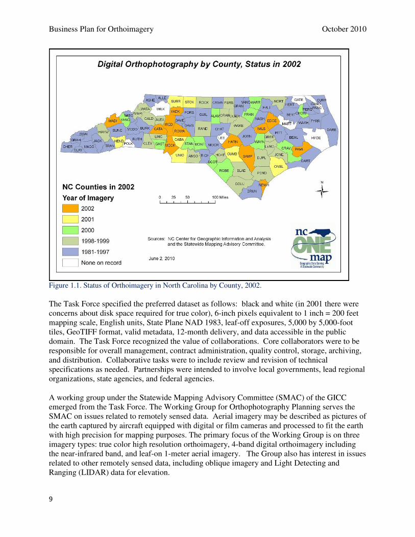
The status of high resolution digital aerial imagery in 2002 fell far short of a statewide resource. Only 31 of 100 counties had acquired orthoimagery over the most recent three years (2000-2002, see Figure 1.1). For a statewide program with a goal of imagery not more than four years old, the pace should have been 75 counties over three years. From the statewide perspective, nearly half of the counties had imagery captured five or more years ago (39 counties) or no digital imagery available (7 counties).
Business Plan for Orthoimagery October 2010
9
Figure 1.1. Status of Orthoimagery in North Carolina by County, 2002.
The Task Force specified the preferred dataset as follows: black and white (in 2001 there were concerns about disk space required for true color), 6-inch pixels equivalent to 1 inch = 200 feet mapping scale, English units, State Plane NAD 1983, leaf-off exposures, 5,000 by 5,000-foot tiles, GeoTIFF format, valid metadata, 12-month delivery, and data accessible in the public domain. The Task Force recognized the value of collaborations. Core collaborators were to be responsible for overall management, contract administration, quality control, storage, archiving, and distribution. Collaborative tasks were to include review and revision of technical specifications as needed. Partnerships were intended to involve local governments, lead regional organizations, state agencies, and federal agencies.
A working group under the Statewide Mapping Advisory Committee (SMAC) of the GICC emerged from the Task Force. The Working Group for Orthophotography Planning serves the SMAC on issues related to remotely sensed data. Aerial imagery may be described as pictures of the earth captured by aircraft equipped with digital or film cameras and processed to fit the earth with high precision for mapping purposes. The primary focus of the Working Group is on three imagery types: true color high resolution orthoimagery, 4-band digital orthoimagery including the near-infrared band, and leaf-on 1-meter aerial imagery. The Group also has interest in issues related to other remotely sensed data, including oblique imagery and Light Detecting and Ranging (LIDAR) data for elevation.
Business Plan for Orthoimagery October 2010
10
The Working Group is responsible for maintaining an inventory of the status of orthoimagery at the county level, including year of latest imagery and previous years of imagery. The group develops procedures for distribution of aerial imagery among state agencies and the US Geological Survey representing federal agencies. Compressed imagery is downloadable through the NC OneMap database (www.nconemap.gov).
The group is charged with seeking sources of funding to assist counties and state agencies in acquiring high resolution imagery. Funding sources in recent years have included the following: NC 911 Board, USGS National Geospatial Program, National Geospatial Intelligence Agency, Department of Homeland Security, NC Floodplain Mapping Program (and the Federal Emergency Management Agency), National Oceanic and Atmospheric Administration, US Department of Agriculture, NC Department of Agriculture and Consumer Services, Department of Environment and Natural Resources, counties and cities, and public utilities.
In addition, the group serves as a technical advisory team for standards and imagery acquisition projects. Recent examples include the new technical specifications for digital orthoimagery from the Land Records Management Program, NC Secretary of State’s Office (adopted in October 2009), the Statewide Orthoimagery 2010 project, the US Department of Agriculture, National Agriculture Imagery Program (NAIP) leaf-on, 1-meter resolution imagery, and county projects involved in USGS Cost-Share cooperative agreements.
A national strategy emerged in 2004-2005 from the National States Geographic Information Council (NSGIC) that became the “Imagery for the Nation” initiative. This is an organized national effort to acquire imagery over the entire USA, consisting of multi-resolution products (e.g., 6-inch, 1-foot, and 1-meter) with repeat cycles of 1 to 5 years depending on location and resolution. Imagery products are accessible in the public domain and are consistent with national standards (image type, quality, format and security concerns). The approach is for states to manage part of the program through development of business plans, the federal government to fund a basic program, and imagery users to fund buy-up options and cost-share to complete coverage of high-resolution products.
The GICC reviewed the recommendations of the Task Force (2003) and adopted a “Statement of Direction for High Resolution Digital Aerial Imagery” in August 2003, and after more review and consideration of the Imagery for the Nation initiative, adopted the following resolution in November 2005 http://www.ncgicc.com/Portals/3/documents/resaerialimagerync.pdf.
Resolution in Support of Aerial Imagery for North Carolina Whereas, aerial imagery, in the form of digital orthophotos, is the foundation for most public and private geographic information systems in North Carolina; and Whereas, this aerial imagery is developed by local, state, and federal government agencies in various pixel resolutions at widely irregular intervals, sometimes with costly duplication of efforts; and Whereas, the Geographic Information Coordinating Council (GICC), established in August 2001 by North Carolina General Statutes §143-725 through 143-727, is responsible for advising the Governor, the General Assembly, and State Chief Information Officer as to needed directions, responsibilities, and funding regarding geographic information; and
Business Plan for Orthoimagery October 2010
11
Whereas, the GICC adopted the NC OneMap initiative that seeks to integrate local government digital orthophotoimagery within a statewide Internet web-mapping service to better serve all government agencies and citizen information needs; and Whereas, the NC OneMap Strategic Plan and Financing Strategy adopted by the GICC in 2004 attests to the economic benefits of acquiring and refreshing aerial imagery across the state on a regularly scheduled basis; and Whereas, the National States Geographic Information Council (NSGIC) passed an “Aerial Imagery for the Nation” initiative that requests federal leadership and financial support for aerial imagery to be acquired and refreshed on a three-year cycle; and Whereas, the “Aerial Imagery for the Nation” initiative relies on NSGIC members to involve their state Councils to actively engage with public and private sector stakeholders and present the merits of this proposal to the federal government and Congress; and Whereas, the GICC vision for a robust statewide aerial photography program in North Carolina is completely aligned to the same objectives in the “Aerial Imagery for the Nation” initiative. NOW, THEREFORE, BE IT RESOLVED THAT THE NORTH CAROLINA GEOGRAPHIC INFORMATION COORDINATING COUNCIL endorses the “Aerial Imagery for the Nation” initiative advanced by the National States Geographic Information Council. Further, it is resolved that the GICC will actively promote this initiative to statewide stakeholders, state and local government leadership, and the North Carolina Congressional delegation.
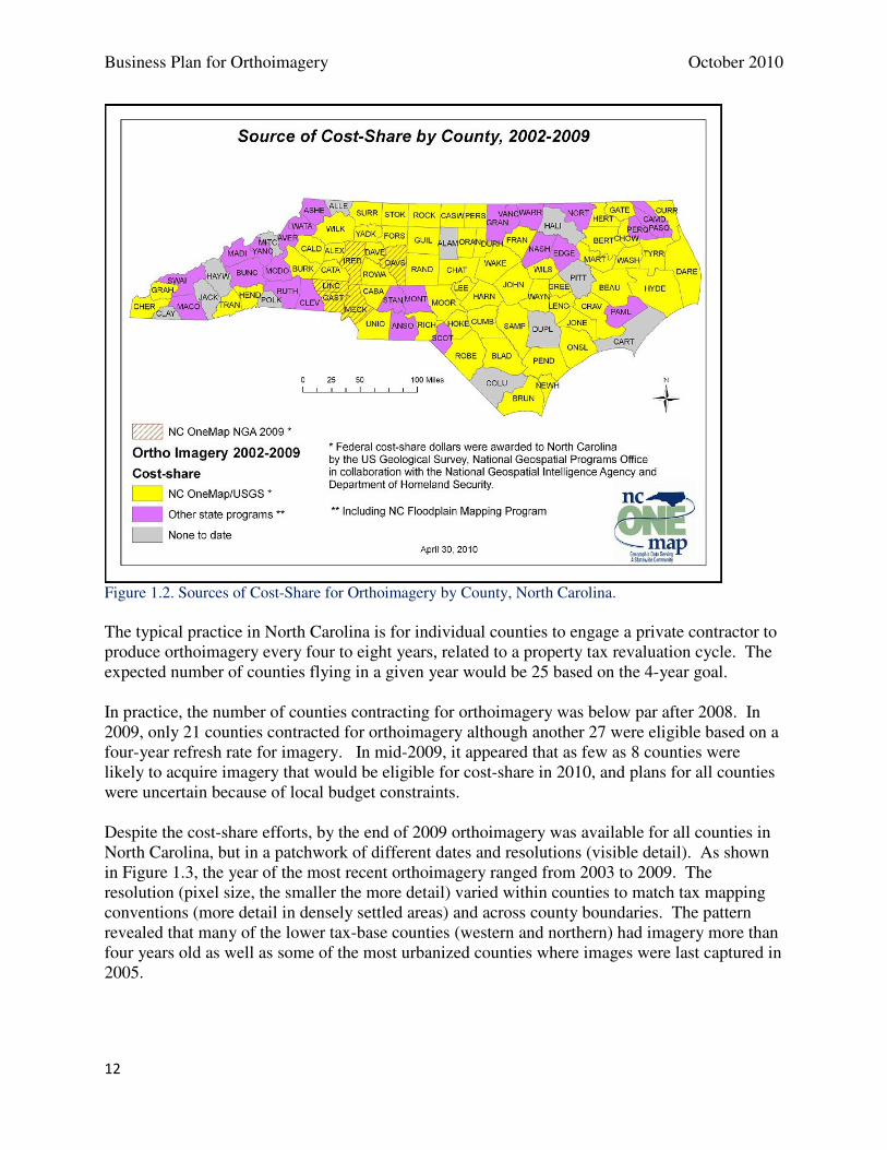
Consistent with the direction of the GICC, North Carolina found ways to reimburse counties for a portion of local costs in the acquisition of high resolution aerial imagery during 2005 to 2009. There were three sources of funds.
(1) The US Geological Survey (USGS) and CGIA entered into cooperative agreements in each of those years to apply federal dollars to local cost-share projects. The National Geospatial Intelligence Agency (NGA) provided funds in urban areas to supplement USGS funds. The Department of Homeland Security provided funds in coastal hazard areas to supplement USGS funds. In 62 instances, counties received federal funds ranging from 10 to 25 percent of costs in return for sharing the imagery datasets with CGIA, USGS and partnering state agencies.
(2) The Geospatial and Technology Management Office (GTM) in the NC Division of Emergency Management acquired imagery or shared the costs of imagery (up to 50 percent) with 23 counties during 2005 to 2009. Datasets supported maintenance of Flood Insurance Rate Maps under the NC Cooperating Technical State agreement with the Federal Emergency Management Agency.
(3) The NC Geological Survey, with state hurricane recovery funds, shared orthoimagery costs in two counties in western NC.
The participating counties are displayed in Figure 1.2. A few counties (12 of 100) had not participated in cost share projects as of 2009.
Business Plan for Orthoimagery October 2010
12
Figure 1.2. Sources of Cost-Share for Orthoimagery by County, North Carolina.
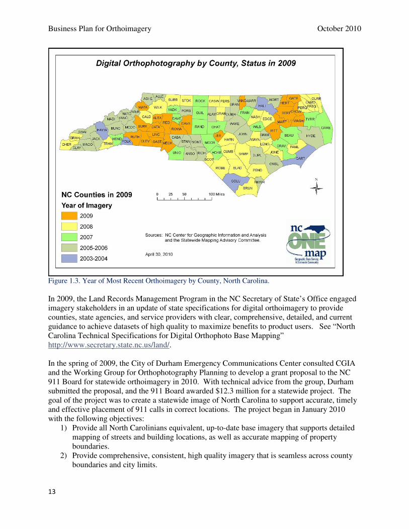
The typical practice in North Carolina is for individual counties to engage a private contractor to produce orthoimagery every four to eight years, related to a property tax revaluation cycle. The expected number of counties flying in a given year would be 25 based on the 4-year goal. In practice, the number of counties contracting for orthoimagery was below par after 2008. In 2009, only 21 counties contracted for orthoimagery although another 27 were eligible based on a four-year refresh rate for imagery. In mid-2009, it appeared that as few as 8 counties were likely to acquire imagery that would be eligible for cost-share in 2010, and plans for all counties were uncertain because of local budget constraints. Despite the cost-share efforts, by the end of 2009 orthoimagery was available for all counties in North Carolina, but in a patchwork of different dates and resolutions (visible detail). As shown in Figure 1.3, the year of the most recent orthoimagery ranged from 2003 to 2009. The resolution (pixel size, the smaller the more detail) varied within counties to match tax mapping conventions (more detail in densely settled areas) and across county boundaries. The pattern revealed that many of the lower tax-base counties (western and northern) had imagery more than four years old as well as some of the most urbanized counties where images were last captured in 2005.
Business Plan for Orthoimagery October 2010
13
Figure 1.3. Year of Most Recent Orthoimagery by County, North Carolina.
In 2009, the Land Records Management Program in the NC Secretary of State’s Office engaged imagery stakeholders in an update of state specifications for digital orthoimagery to provide counties, state agencies, and service providers with clear, comprehensive, detailed, and current guidance to achieve datasets of high quality to maximize benefits to product users. See “North Carolina Technical Specifications for Digital Orthophoto Base Mapping” http://www.secretary.state.nc.us/land/. In the spring of 2009, the City of Durham Emergency Communications Center consulted CGIA and the Working Group for Orthophotography Planning to develop a grant proposal to the NC 911 Board for statewide orthoimagery in 2010. With technical advice from the group, Durham submitted the proposal, and the 911 Board awarded $12.3 million for a statewide project. The goal of the project was to create a statewide image of North Carolina to support accurate, timely and effective placement of 911 calls in correct locations. The project began in January 2010 with the following objectives:
1) Provide all North Carolinians equivalent, up-to-date base imagery that supports detailed mapping of streets and building locations, as well as accurate mapping of property boundaries.
2) Provide comprehensive, consistent, high quality imagery that is seamless across county boundaries and city limits.
Business Plan for Orthoimagery October 2010
14
3) Give E911 call dispatchers confidence in the images and maps displayed in Public Safety Answering Points (PSAP) across the state.
4) Create a statewide geospatial building block for the next generation of E911. 5) Realize the full potential of the NC OneMap data clearinghouse for organizing and
providing access to statewide, high-resolution imagery. 6) Support employment and income in North Carolina through state-licensed contractors
and domestic data processing operations. In summary, the context for a business plan for orthoimagery was years of planning and preparation within the state’s coordination framework, clear direction from the GICC, updated specifications for orthoimagery, demonstrated collaboration among state and federal agencies, effective cost-sharing for county acquisition of imagery, shortcomings in statewide imagery in terms of currency and resolution, and a statewide project to produce a common dataset for all 100 counties in support of 911 and geospatial operations. Key stakeholders in North Carolina’s orthoimagery program and their respective roles in the state are listed and described in Appendix A.
Business Plan for Orthoimagery October 2010
15
2. Purpose
The purpose of a business plan for orthophotography is stated in the State Geographic Information /Consolidation Implementation Plan, as directed by Session Law 2008-0107 Section 6.13, December 2008. Recommendations 13 through 17 in the GIS Study (the foundation of the implementation plan) state the objectives relating to orthoimagery as follows:
Recommendation 13 GICC/CGIA and the Land Records Management Program (in the Department of the Secretary of State) should coordinate a statewide flyover for orthophotography both logistically and via funding across the different levels of government. This should be based on a four-year cycle to complete and maintain the statewide coverage. Recommendation 14 GICC/CGIA and the Land Records Management Program should implement an aggregate cost share model with the Counties contributing 50%, the State contributing 25% and the Federal Government contributing 25% for the leaf-off product based on the Technical Specifications for Digital Mapping (Orthophotos) GS 102-17, Land Records Management Division, North Carolina Secretary of State, as adopted by the GICC. Recommendation 15 Consideration should be given regarding the 50% County participation to ensure counties with very high growth which require more frequent orthophotography pay more of a share versus counties with little to no growth who should pay a much smaller to no share of the cost. Recommendation 16 Subject to inclusion in the Governor’s Recommended Budget for 2009-2010, appropriate 25% (or $635,625) to the GICC for the State’s participation and/or Recommendation 17 Request 911 Board to review the language pertaining to the 911 Fund to consider specifically allocating monies for the State flyover. Implementation Steps: The position stated by Recommendations 13 and 14 has been the GICC's goal for a number of years. It was the basis for the original estimate in the NC OneMap five-year funding plan several years ago. This “leaf-off” product (i.e., orthophotography flown in the winter when most vegetation is bare) is based on the Technical Specifications for Digital Mapping (Orthophotos) GS 102-17, Land Records Management Division, North Carolina Secretary of State, as adopted by the GICC. Members of the GICC and CGIA have been working with federal partners for a number of years to leverage available federal funds to cost share with counties for orthophotography. Statewide funding has not been available. Therefore, plans have been limited to individual counties or groups of counties, with no consistency of scheduling. The Statewide Mapping Advisory Committee (through the GICC) has played a key role in detailed planning. The Department of the Secretary of State, Land Records Management Program, is fully engaged in this process and should be considered as the data steward for this data layer. This implies that the funding and the accountability are part of that stewardship role. In the past, CGIA has dealt directly with federal funds that have been provided for this purpose. However, state appropriated funding for
Business Plan for Orthoimagery October 2010
16
orthophotography falls under the statutory authority of the Secretary of State. The agencies should work together under the framework of the GICC to coordinate funding to achieve the statewide flyover. Orthophotography is clearly the fundamental building block for GIS across North Carolina. It is in the best interest of the State to make a substantial investment in this data layer. Therefore, the State should take responsibility for its development by funding 100% of the cost ($2.6M) for this key data layer rather than the 25% State contribution specified in Recommendation 14, with the augmentation of federal funding, when available. The 100% funding level will need to be achieved gradually over several years. Orthophotography is also a critical layer for emergency response purposes. Therefore, the 911 Fund could be an appropriate mechanism to fund a portion of this effort. The next step is preparation of a business plan for orthophotography that addresses Recommendations 13-17. The plan will include roles and responsibilities of stakeholders, contracting procedures, a process for allocation of funds from sources including federal, State, and local, best practices, and buy-up opportunities. Creation and adoption of the business plan will occur with the full participation and acceptance of the GICC.
3. Program Goals
North Carolina’s orthoimagery has two goals that build on the Background and Purpose stated above, consistent with recommendations from the GIS Implementation Plan. These two goals are the focus of this business plan:
a. Achieve a new statewide set of orthoimagery. The current statewide project for orthoimagery acquisition in 2010, funded by a $12.3 million grant from the NC 911 Board to the City of Durham Emergency Communications Center, will meet this goal by early 2011.
b. Establish a sustainable program for keeping high resolution statewide orthoimagery
current and accessible. “Sustainable” means a consistent, successfully funded program. “Current” means that imagery was captured within one of the last four years on a county basis. “Accessible” means that imagery users have online access to map services and downloadable files, and that online map services meet user requirements to support client applications.
Business Plan for Orthoimagery October 2010
17
4. Program Benefits
A. Framework for Benefits
Orthoimagery serves a wide range of users with a visual representation of features on the earth, a reliable base map for measuring distance, and a recording of light reflectance that give clues about the properties of surfaces and vegetation. Orthoimagery helps users answer questions about locations, distance, connections, proximity, surface waters, and structures. Timely emergency response, accurate and fair property tax assessment, more effective land use planning by local governments, efficient timber management, and timely delivery of products are examples of public and private benefits of regular, high resolution, accessible orthoimagery. North Carolina’s orthoimagery program is intended to share and sustain benefits statewide. Orthoimagery program benefits have been documented in the NC Statewide Orthoimagery 2010 project, reports generated by the GICC and its committees, NC OneMap staff, and reports by the Imagery for the Nation program. The Imagery for the Nation, Cost Benefit Analysis published in July 2007 by the US Geological Survey has an introduction that outlines the benefits of high resolution orthoimagery:
Advances in technology over the last decade have made it easy for individuals and organizations to acquire and utilize imagery in a number of different ways. Organizations use orthoimagery to analyze, develop, and implement public policy related to: health services, homeland security, transportation, agriculture, surveying and mapping, hazards and wildfire response, energy development, land use, economic development, growth management, and many other business needs. Some applications of orthoimagery include:
• Post-event evaluation and strategic planning for use by first responders who require orthoimagery to lessen loss of life and property and to improve the response time through proper identification and coordination of activities. • Precision agriculture or farming which uses tools such as orthoimagery to determine the correct amounts of fertilizer used on each acre of land. As a result, there are increased efficiencies in agriculture practices. • Streamlining workflows by aligning environmental, demographic, utilities, political boundaries, public health infrastructure, and other data onto georeferenced data. As a result, relationships can be drawn out that serve as preliminary assessment tools that identify trends, and disparities.
As a result, demand has increased dramatically. Government agencies at the Federal, State, and Local levels also have acknowledged the value of imagery and have begun to use it in conjunction with Geographic Information Systems (GIS) technology to streamline workflows, decision processes and to effectively coordinate their efforts. Orthoimagery is the base layer for many other data themes associated with GIS technology. There is a direct correlation between these data themes, GIS technology, and user applications…
The Imagery for the Nation (IFTN) Cost Benefit Analysis describes non-quantifiable benefits of an orthoimagery program (Table 4-11 in the IFTN report). Benefits may be organized in three categories: End-user value, governmental operational value, and private industry value.
Business Plan for Orthoimagery October 2010
18
B. Benefits in North Carolina
Orthoimagery benefits a wide range of users of geospatial data, including private industry, public agencies, nongovernmental organizations, citizens, and educational institutions. Imagery users in North Carolina include county and city GIS practitioners and property mappers; county and municipal 911 call centers, Lead Regional Organizations, geospatial data users in state agencies (including NCDOT photogrammetry and GIS units, numerous NC DENR divisions, NCDA&CS, DCCPS divisions and programs, DHHS, and CGIA), federal agencies (including USFWS, USGS, NOAA, USACE), nongovernmental organizations (e.g., land trusts and foundations), 16 public universities and other higher educational institutions, private industry related to engineering, surveying, environmental services, planning, consulting, and GIS services, as well as citizens. For example, NCDOT prepared for likely federal stimulus dollars for transportation by identifying potential projects that could be done within months, such as bridge replacements. NCDOT had data stored locally including orthoimagery, LIDAR, and cadastral data from counties. Even with varying resolution and currency of the orthoimagery, the available images were invaluable in reporting on specific sites. A consistent baseline set of imagery (under production for 2010) will make the reporting more consistent and reliable and reduce time needed in the field to verify site characteristics. Applications of orthoimagery by end-users include a geospatial reference for:
• location orientation: images with recognizable features such as roads, streams, shorelines, fields, or landmarks
• base mapping: county and town boundaries, street centerlines, property boundaries, structure outlines, address points, and other map features
• thematic mapping: flood hazard areas, land cover, impervious surface, wetlands, farm fields, forests, sea grass, shoreline and other themes
• facility mapping: utilities, public works, state-owned buildings, parks, recreational structures, and other facilities
Many benefits of an orthoimagery program to end-users are not quantifiable but are valuable in efficient and effective mapping, analysis, planning and decision support. End-user value may be expressed as:
• Access to current and historical imagery in the public domain, including access and distribution through NC OneMap
• Reliability of product and schedule
• Continuity of process and funding
• Opportunities to meet additional business requirements with buy-up options such as color-infrared imagery or extracted map features
• Increased interoperability across jurisdictions through consistent datasets and cross-jurisdictional applications
• Common source data
• Higher resolution imagery for local users than previously available in some cases
Business Plan for Orthoimagery October 2010
19
• Access to consistent historical products
• More applications available for decision support
• Increased user base through easier discovery of and access to imagery products An orthoimagery program benefits governmental operations at all levels of government. Value may be described as:
• Quality and consistency in operating data within and across jurisdictions
• Reliability of product and schedule to support planning, budgeting and analysis
• Standardization of procurement processes
• Application of standard data specifications and best practices
• Creation of economies of scale through consolidation of planning, budgeting, contracting and project management
• Interagency interoperability and consolidation of data storage and distribution
• Increased government user base through direct applications and service provider solutions
• More effective use of resources for other projects and programs that may include Framework datasets such as elevation, thematic datasets such as building outlines, and analysis such as current land use.
In emergency response by local government operations, benefits may be described as:
• Emergency responders get to the incident more quickly
• Emergency response has a better understanding of what will be required when they arrive
• Emergency response is better prepared in case assistance is needed outside of their region
• Time savings in call answering and response from better quality ortho imagery available to call centers (quality = consistency, currency, detail)
Other public examples of benefits include the following:
• Imagery informs accurate and fair assessment of local property taxes based on property boundaries and structures
• Natural hazard mitigation tasks rely on a picture of conditions before an event to better define ways to limit damage
• Understanding of locations of needs for specific public services
• Orientation and documentation of land, buildings, transportation and other features are important to economic developers
• Geospatial information dissemination o Road Centerline gathering o Structure collection o Parcel information gathering o Time savings in local tax offices, GIS operations and related local operations
Business Plan for Orthoimagery October 2010
20
Specific examples of the value of current, accurate base maps (referenced to orthoimagery) in North Carolina include the following:
1. The US Census indicates that one person missed in the count constitutes $1500 missed in federal funds per year for 10 years. Being able to count all residents in the correct locations (jurisdictions) translates to full allocations of federal dollars to counties and municipalities.
2. NC DOT is tasked with distributing a share of the gasoline tax to the municipalities through the Powell Bill Fund Program. Municipal boundaries and street centerlines must be documented so the Powell bill Funds can be properly distributed.
3. NC department of Revenue assesses licensed utilities for Franchise Taxes value. The Town of Knightdale received an additional $450,000 per year in Franchise Taxes by providing accurate locations of utility customers based on geosptial datasets.
4. The City of Raleigh uses orthophotography to calculate impervious area and to document additional impervious area for city storm water fees. The storm water fee not only pays for the program but pays for orthophotography each year.
An orthoimagery program benefits the geospatial data industry and other private businesses. Service providers include contractors or subcontractors for aerial image acquisition, image processing, quality control, maintenance of base mapping layers, creation and maintenance of thematic layers, custom mapping, and mapping applications. Orthoimagery producers in North Carolina have included large firms that are national in scope, medium firms with regional scope, and small firms that work primarily within the state. There are many small firms in North Carolina that respond to a market that has been dominated by frequent locally-funded imagery projects. Private organizations that derive data from orthoimagery in North Carolina are national, regional, and statewide in scope, with many examples of state-based service providers that develop and maintain datasets for local geospatial operations and information technology. Industry value may be expressed as:
• Increased opportunity for value added services including feature extraction, base mapping, and processing of color infrared imagery
• Guidance for coordinating efforts across counties and in service to state agencies
• Common source data for applications across the state
• Improved planning and scheduling of workflow for professional service providers
• Positive economic impact
• Increased customer base Many more private or nonprofit organizations derive benefits from current, high resolution imagery in applications related to real estate, product delivery, engineering, planning, environmental assessment, and a variety of other uses. Benefit measures include the following:
a. Time / efficiency for informing public decisions b. Currency of imagery and features (cost of misinformation) c. Time for handling, storing, retrieving, displaying, archiving

Business Plan for Orthoimagery October 2010
21
Measuring benefits and translating to dollars is difficult and approximate, but useful in framing the value of statewide orthoimagery. In the 2010 statewide orthoimagery project, the benefits may be described as follows.
(1) County/city operational savings: for 2010-2013, the estimated benefit to counties and cities of not contracting for orthoimagery individually is estimated to be $10.4 million. The estimated annual benefit is $2.6 million over four years.
(2) County and city and state time savings from fewer requests from state and federal agencies (datasets are available from NC OneMap); assume annual rates: 24 requests per year, 2 hours to fill each request, at least 100 jurisdictions.
(3) County and city and state time savings from fewer requests from private and public entities (datasets are available from NC OneMap); assume annual rates: 12 requesting agencies, 2 requests per year, 2 hours to fill each request, at least 100 jurisdictions.
(4) Time savings in call answering and response from better quality orthoimagery available to call centers (quality = consistency, currency, detail); assumes 3.5 hours saved per week in at least 100 jurisdictions.
(5) Time savings in local tax and GIS operations and related local operations (quality = consistency, currency, detail); assumes 2 hours saved per week in at least 100 jurisdictions and 1.5 hours saved per week in state agencies relating to 100 jurisdictions.
Business Plan for Orthoimagery October 2010
22
5. Requirements
Requirements for a statewide orthoimagery program may be described as business requirements, data requirements, and functional requirements.
A. Business Requirements
Orthoimagery is the ultimate base map, recognizable to an every growing audience and suitable for reference and analysis to derive and enhance geospatial datasets. Orthoimagery in North Carolina adds value to three primary business uses: visual reference, data creation and maintenance, and image analysis. This section describes requirements for each of the business uses in terms of users, applications, and associated data products. 1. Visual Reference For years county governments have provided the majority funding for orthoimagery in North Carolina. County investments in orthoimagery have enabled extensive mapping of land parcels in all 100 counties to support fair and accurate property tax assessment. Visual reference is very important to parcel mapping. The ability to position a deed description on a map by using visible features such as roads, streams, tree lines, fence lines, and buildings is the only cost effective process for developing a cadastral map for taxation. For appraisal of structures (improved real property), current orthoimagery is an essential reference source. A more recent requirement for complete and current orthoimagery is to serve as a visual reference for 911 call centers. With the prevalence of 911 calls from mobile phones that generate Global Positioning System (GPS) coordinates (latitude and longitude), georeferenced imagery as a base map along with street centerlines and jurisdictional boundaries are invaluable in establishing a call location and its implications for emergency response. The majority of imagery uses are for visual reference. Compressed imagery or online map services are the most suitable formats to meet needs for visual reference. 2. Geospatial Reference Counties use orthoimagery as a geospatial reference for data creation and maintenance. Features in the imagery guide digitizing of street centerlines, and survey data may be displayed over imagery to verify locations. Development of address points based on visible structures in orthoimagery is becoming more common in county GIS operations. State users apply imagery to creation and maintenance of a wide range of datasets, including transportation features, wildlife habitat, streams, building footprints, and shoreline to name a few. Private users apply imagery to delineation of forest stands, farm fields and electric utilities as a few examples. GIS desktop tools enable data creation and maintenance based on imagery for a wide range of users.
Business Plan for Orthoimagery October 2010
23
The second most common imagery uses are for geospatial reference. Compressed imagery or online map services are the most suitable formats to meet needs for geospatial reference. 3. Image Analysis Image analysis involves specialists who have the tools and knowledge to extract features from imagery (e.g., structure outlines, shorelines, highway surfaces), classify pixels to represent vegetated land cover, and other operations that interpret what the digital sensors captured. Counties use image analysis to measure area relating to mapped property deeds and compare to area noted in deed descriptions. Some jurisdictions are analyzing impervious surface from orthoimagery, and applying results to stormwater fees that are based on impervious surface amount. Changes in impervious surface amounts are analyzed for floodplain management and planning. In terms of users and applications, image analysis is in the minority, but there are benefits to be realized. Uncompressed imagery or online map services are the most suitable formats to meet needs for image analysis. Adding the fourth band to create color infrared imagery (discussed below) adds value for image analysis involving classification of vegetation type and condition, impervious surface delineation, and wetlands detection.
B. Data Requirements
1. Specifications for Statewide Imagery Imagery product specifications for future projects will be based on current technology and best practices, will satisfy NC specifications for quality and accuracy, and will provide the best value to users statewide. Imagery will satisfy “North Carolina Technical Specifications for Digital Orthophoto Base Mapping” http://www.secretary.state.nc.us/land/. Specifications relate to all aspects of orthoimagery, including pixel resolution and positional accuracy (map coordinates of an image feature represents the actual location on the ground) and image quality relating to shadow penetration, realistic colors, seamless mosaics, and undistorted transportation features. In the 2010 statewide project, data specifications included orthoimagery produced in 5,000 by 5,000-foot tiles with ground resolution of 6 inches, amounting to 100,000,000 pixels per tile. Format is true color (3-band) in GeoTIFF format. The Coordinate Reference System is NC State Plane Coordinate System, NAD 1983 (NSRS 2007) Datum, with units of US Survey feet. Tiles have unique names and use a new naming convention (32 characters). Statewide there are approximately 60,200 tiles over land and water. The common resolution across the state (6-inch ground resolution) was a requirement for the 2010 project. For future projects, State specifications would accommodate a mix of resolutions with a maximum of 1-foot resolution. Future projects could consider higher resolution in urbanized areas to capture sharper edges to structures, and lower resolution over forests and fields where there are few structures.
Business Plan for Orthoimagery October 2010
24
The disk storage space for uncompressed images (GeoTIFF format) is estimated at 294 MB per tile, translating to a disk storage space requirement of approximately 17 TB. In the 2010 project, GeoTIFF (uncompressed) images are not being stored for online access. Given current technology and practice, compressed imagery meets the needs of most users, including performance in client applications. In the 2010 project, the orthoimagery will be compressed by a ratio of 20 to 1 in MrSID format. Estimating for one-fifth of the disk space for compressed imagery, the total for statewide MrSID tiles would be less than 900 GB. For the 2010 project, compressed imagery will be stored for online access.
For the 2010 project, map services will be created for online access to imagery. The project plans to create at least one cache of statewide imagery to support faster rendering of images in client’s own desktop and web applications.
County mosaics, compressed by a ratio of 50 to 1, will be produced for each county in the 2010 project. Total disk space would be approximately 381 GB for mosaics (necessarily including overlapping tiles). Mosaics will be delivered offline, but not offered for download because of the large file sizes and current bandwidth.
For the 2010 project, digital elevation model (DEM) datasets used in the processing of orthoimagery will be available from the NC Floodplain Mapping Program. The datasets are based on LIDAR data captured during 2000-2005. If the DEMs generated from LIDAR data need to be modified (because of significant ground disturbance such as a new highway interchange), the county files will be a deliverable. If not modified, the data will be downloadable from NC FMP. Datasets vary in size by county. The DEM used for Brunswick County, one of the largest, consumed 3.5 GB of disk space. The DEM used for Chowan County, one of the smallest, was 200 MB.
Other files required for the 2010 project include metadata records at the county level, compliant with state standards, for GeoTIFF and MrSID datasets. A statewide tile index shapefile and county index shapefiles will be available from the project. Data fields will include the new 32-character conventional name. Imbedded in the name is an 8-character modular unit number generated from corner coordinates that is unique.
Total disk storage space requirements for the 2010 orthoimagery project will amount to approximately 3 TB including 2010 imagery and imagery produced from flights in 2009 and earlier. For potential caching of imagery for map services, the priority geospatial projection for caching purposes in the 2010 project is geographic units in decimal degrees (latitude and longitude) to be consistent with 911 business operations and the current NC OneMap map viewer. The secondary projection for caching will be state plane coordinates, English units.
Business Plan for Orthoimagery October 2010
25
2. Requirements for Storage and Access to Interim Imagery Files
The scope of the 2010 statewide project did not include color infrared imagery deliverables which would have required a second set of image products at a significant additional cost. During the 2010 project, the Working Group identified potential benefits from imagery data that has been processed to an interim stage where it is ready for “exploitation” into orthorectified images. From that interim product, specialists may generate 3D imagery, color infrared imagery (using the fourth band that is not used in the true color products), and topographic products. The requirements for storage (several times larger than finished products) and access to interim imagery files (not deliverables in the 2010 statewide project) are attached as Appendix B.
C. Functional Requirements
To achieve full benefits to imagery users in North Carolina, imagery should be available in multiple formats and via multiple delivery mechanisms. A single solution will not satisfy the needs of all users. Users of imagery in desktop software applications have very different needs and expectations than users of web-based map viewers. Image analysts and geospatial professionals have much more demanding requirements for data access than the general public. A multi-faceted approach is required to accommodate the many different constituents of image delivery solutions for North Carolina.
The primary functional requirement for orthoimagery is to be readily available, free of charge, to local government 911 and GIS operations and to a wide range of private and public users for visual reference, geospatial reference, and image analysis. Statewide orthoimagery should enable three basic functions:
1. Data Discovery
• Compressed imagery metadata records should be loaded and searchable
• NC OneMap GIS Inventory should be current including imagery by county
• Users may easily discover imagery files available (by year of image capture) for an area of interest
• Users may easily discover vector files available for an area of interest
2. Data Viewing
• Imagery should be readily viewable (software creates the equivalent of a mosaic based on map extent)
• Imagery should be accessible (via map services) for client applications including web map viewers and desktop GIS
• Imagery delivery (jpg rendered on server) after receipt of request should meet performance expectations (network performance and client performance will vary)
• Tile index should be available for download in a collection of vector files
Business Plan for Orthoimagery October 2010
26
3. Data Download
• Compressed imagery should be available for download by a user-defined area, with a limit on file size. For example, the statewide project in 2010 will enable download of approximately 540 MB (equivalent to 36 compressed tiles).
• Compressed imagery from earlier years should be available for download by a user-defined area, with a limit of approximately 540 MB (equivalent to 36 compressed tiles)
• Download functionality should enable users to extract imagery for an area of interest and receive a dataset online.
• Vector datasets should be available for download, for example as zipped shapefiles. The Working Group did research on data formats and data delivery and access solutions. The findings are as follows. 4. Data Format
Master or archival copies of imagery should use uncompressed GeoTIFF image format. Image and remote sensing analysts will also require imagery in uncompressed GeoTIFF, but this is a very small user group. At some point in the future, lossless JPEG 2000 may become the preferred image format for archival or analysis, but it is not a suitably mature and or consistently implemented format yet.
Recommended “general distribution” formats are ECW or MrSID format. Both offer much smaller files than GeoTIFF images. They are generally well supported (at least for read operations) by most GIS and Computer Aided Design software packages. ECW is slightly more accessible, in that a number of the open source GIS packages do not support MrSID format. ECW or MrSID format imagery is suitable for download on public FTP sites.
Both ECW and MrSID formats are conducive to producing single-image mosaics of smaller and medium-sized coverage areas (cities or counties) while still maintaining a reasonable file size. Users who need larger coverage areas (river basins or full state) will be better served by imagery that has been tiled using a rectangular grid, so that a seamless raster image catalog can created in their desktop software of choice. The most common tiling system used with medium resolution imagery (ex: USDA NAIP with 1-2m pixel resolution) is the USGS Digital Orthophoto Quarter Quad (DOQQ) grid. In this system, each image tile dimension spans 3.25 minutes of longitude/latitude (~3.1 miles). For higher resolution aerial imagery, such as the 6-inch to 1-foot pixel resolution imagery typically flown by county land records departments, smaller tiles are more useful because the file sizes are larger. In North Carolina, the tiling system of record is a 10,000-foot square “Basic Modular Unit“ as mandated by the Technical Specifications for Digital Orthophoto Base Mapping, as published by the NC Land Records Management Division of The Secretary of State’s Office. The statewide project uses a subdivision of the basic modular unit (quadrants measuring 5,000 by 5,000 feet).
Business Plan for Orthoimagery October 2010
27
5. Data Delivery and Access
A copy of an imagery dataset should be maintained in uncompressed GeoTIFF format as the
“master” or “archival” version. This version of the imagery should be delivered using a variety
of methods, for different user groups:
• If disk space on the map server is adequate, to power a WMS map service that outputs ad-hoc rendered images for general map viewer or desktop GIS use. Either as a file-based image catalog, or as a layer in a spatially enabled database.
• Via portable hard drive or WCS services for access by remote sensing and image analysts who need the full resolution imagery to perform their analysis and modeling operations. Small study areas may be obtained from a WCS, but large areas will need to be transferred in an offline manner.
• Optional - If disk space on the map server is adequate, the imagery should be pre-rendered into map tiles and served as a WMTS service for use in web mapping clients.
• Optional - If the software is available, the imagery may be ingested into a Globe server to power visualization services in the associated Globe viewer client.
A copy of an imagery dataset should be converted to a highly compressed format such as ECW
or MrSID for general use as map backgrounds. This version of the imagery should also be
delivered using a variety of methods, for different user groups:
• Over a Local Area Network (LAN) as an image catalog or in a spatially enable relational database layer for use by desktop clients in the same facility as the fileserver. This is needed to print large, high quality maps.
• Zipped, and made available for Internet downloads using FTP / HTTP / WGET.
• Optional – packaged for use on mobile devices
• Optional, and only marginally viable – served over a Wide Area Network (WAN) as an image catalog or in a spatially enable relational database layer for use by desktop clients in nearby facilities, provided the WAN speed is T3 or better.
More detail on image formats and technical solutions is attached as Appendix C.
Business Plan for Orthoimagery October 2010
28
6. Program Costs
What is the cost of orthoimagery? This section offers estimates based on recent projects and optional approaches to acquisition. For any county-scale or regional-scale project, most tasks are assigned to private contractors that have invested in equipment, expertise, and methods and are licensed in North Carolina to produce orthoimagery consistent with State specifications. As explained in the funding section below, contractors are typically engaged in a qualifications-based selection process that includes negotiation of price after selection of a qualified contractor. Project components include flight planning, establishing ground control points, image acquisition (flights), aerial triangulation (referencing images to ground control points), creating or updating a digital elevation model, ortho rectification (referencing images to elevation), radiometric processing (color balancing), photo finishing (editing), quality control (visual and positional), and packaging (tiling, compression, mosaic, metadata, and reports). Prices for components of an orthoimagery project are variable from year to year and county to county, influenced in part by contractor investment in equipment, availability of appropriate aircraft, fuel prices, labor costs, flight plan variations to accommodate differences in terrain, availability of digital elevation models, and other factors. Geodetic control managed by the State plays a key role in ground control (surveyed points), positional accuracy (continuously operating reference stations), and quality control (surveyed points and analysis). Cost components also include management of contractors, from evaluating proposals to contracting to product review and acceptance, and management of a statewide program. In addition, data distribution and public access are cost components for a statewide program to assure data sharing to realize benefits to imagery users. The Digital Imagery Task Force (2001) estimated that a statewide project would cost on the order of $30 million, or about $625 per square mile based on the recommended specifications (6-inch ground resolution, one-fourth of the state captured annually) and management of an ongoing program. The statewide imagery project for 2010 has a total cost of $12.3 million for 100 counties and comparable specifications, including investment in geodetic control and investment in data access through www.nconemap.gov. The project did not account for significant costs incurred as in-kind services by state agencies that collaborated on the project, including project planning, contractor management, and technical services. The cost per square mile for the 2010 project is about $253, not including in-kind services. How did the cost of a statewide orthoimagery project decrease from $30 million to $12 million? The cost factor that decreased the most is related to preparation of digital elevation models for orthorectification. North Carolina, through the initiative of the Geospatial and Technology Management Office in the Department of Crime Control and Public Safety in support of the Floodplain Mapping Program, acquired statewide LIDAR (Light Detecting and Ranging) data and generated digital elevation models. These datasets are available to orthoimagery contractors to apply to projects. The 2010 statewide project applied LIDAR datasets, with minor modifications, saving significant time for contractors in orthoimagery processing. Other cost
Business Plan for Orthoimagery October 2010
29
factors include the shift from film cameras to digital sensors with implications for acquisition and processing costs, improvements in geodetic control and positional reference with implications for processing costs, updated state specifications for digital orthophotography, a new aerial camera validation range in North Carolina, a coordinated tile (panel) scheme based on state plane coordinates, and a new tile naming convention for orthoimagery. Orthoimagery projects in 2009 included two groups of counties and an individual county that engaged private contractors to produce orthoimagery by county. Ground resolution varied in some counties (higher resolution in urban areas) and was a uniform 6-inch resolution for others. The groups were able to take advantage of some economies of scale, including the sharing of common tiles at county boundaries (saving production of redundant tiles). There were too many variables in those projects to assume that the costs could be extrapolated to a statewide project. In particular, each project had a single prime contractor, not multiple prime contractors like the 2010 statewide project, and did not invest in geodetic components or information technology. The 2009 projects may represent a best case for county-scale projects because of county collaborations, relatively normal to low demand for flights (21 counties in 2009), and a depressed economy. Contracts for 2009 orthoimagery ranged from $105 to $170 per square mile for groups of collaborating counties. Those private contracts did not include public management and administration time handled by counties and a regional organization, and did not include quality assurance and program management by CGIA in support of cost-share contracts with 10 of the 21 counties (funded by US Geological Survey, National Geospatial Program). A statewide project necessarily has costs related to consistency, quality, completeness, maintenance of infrastructure for positional reference, data management, and public access to information. Considering costs for a statewide program after 2010, a total cost on the order of $250 per square mile or less (or about $12 million) would appear to be achievable for all cost components including geodetic services, program management and data access. The Working Group for Orthophotography Planning identified options for acquisition of orthoimagery that would meet the goal of imagery no more than four years old. The 2010 project is a full statewide approach that creates a common base map across 100 counties. Since initiation of the Digital Imagery Task Force in 2001, other approaches have been considered that would acquire one-half of the state at a time, one-third of the state over four years, and one-fourth of the state on an annual basis. Although the relative cost of each alternative over four years cannot be specified based on information available to the Working Group, a discussion of cost factors informs selection of an approach. For product delivery by county, approximately 5,500 of 59,000 statewide 5,000 by 5,000-foot tiles (about 9 percent) are common to two or more counties (intersect county boundaries). Consequently, a full statewide project minimizes the redundancy in tiles on a county basis. The smaller an annual project, the lower the cost savings from flying multiple counties. Given the geographic size of North Carolina and the number of jurisdictions for data delivery, management of private contractors is a significant project cost. The larger the project, the

Business Plan for Orthoimagery October 2010
30
greater the time requirements to manage multiple teams of contractors to assure consistency in acquisition, aerial triangulation, orthorectification, color balancing, photo finishing, and quality control. In the Working Group’s judgment, the threshold for relatively more intensive project management requirements is about one-fourth of the state. The Floodplain Mapping Program successfully managed acquisition of 17 counties in 2005. From the Program Management perspective, CGIA managed twenty-five county cost-share contracts in one year without having to add supplemental staff. Multiplying that effort by 2, 3, or 4 would have required temporary assistance. The relative project management costs are likely higher for one-half or all of the state than for one-fourth of the state. For future acquisition projects, program managers will need to develop more specific cost estimates that build on the experience of the 2010 project, with attention to ways to deliver the best value for the state. From a qualitative perspective, alternatives are described in the Implementation section, including advantages and disadvantages for data users, data producers, data managers, and program managers.
Business Plan for Orthoimagery October 2010
31
7. Organizational Approach
A. Organizational Structure
To achieve the goals of the Geographic Information Coordinating Council regarding imagery for the state, the SMAC recommends a collaborative approach to future projects to take advantage of experience and expertise across several organizations. As a prime example, the following approach was used in the statewide project in 2010.
• Overall program management was the responsibility of CGIA, staff to the GICC, to take advantage of CGIA’s project management experience and its capabilities to apply the coordination structure of the GICC and its committees and working groups to the statewide orthoimagery planning and implementation.
• Management of imagery acquisition, processing, and visual quality control was the responsibility of the Geospatial and Technology Management Office (GTM) to take advantage of large project management experience, imagery expertise, and data management experience.
• Management of geodetic control and horizontal quality control and related equipment was the responsibility of the NC Geodetic Survey to utilize experience managing and performing quality control in the field, maintaining datasets for control, and managing a statewide network of reference stations. This was in collaboration with GTM for efficient workflow.
• Public access to imagery (map services, data download, and related methods) and distribution of imagery products is being managed through NC OneMap by CGIA. In addition, CGIA is providing outreach in the form of presentations at conferences and other public events along with:
• Maintaining a project web page, such as the one for the 2010 Statewide Orthoimagery project (http://www.nconemap.net/NCOrthos/tabid/425/Default.aspx)
• Materials such as the “Examples of how aerial imagery is used in North Carolina” (http://www.nconemap.com/Portals/7/documents/NCOneMapExamImagery1007.pdf)
• The North Carolina Department of the Secretary of State is required by § 102-17 to establish statewide technical land mapping standards in order to standardize land mapping for county land records. The Land Records Management Program in the Secretary of State’s office serves as the lead agency for statewide technical land mapping standards.
• Technical support and advice is provided by the Working Group for Orthophotography Planning (http://www.ncgicc.com/Default.aspx?tabid=143) in the GICC Statewide Mapping Advisory Committee (SMAC).

Business Plan for Orthoimagery October 2010
32
This organizational structure supports efficiency and effectiveness in meeting a rigorous set of photogrammetry standards relating to collection, processing, quality control, outreach to users, and public access to information. North Carolina is fortunate to essential elements in place, including:
� Agencies that have established working relationships, agreements, and understandings for an effective team approach, and
� Personnel who have expertise in professional services and technology as well as in Qualification-Based Selection (QBS) contracting.
Section B provides more detail on the organizational structure.
B. Organizational Structure Detail
The organizational structure should be composed of (1) qualifications-based selection of contractors, (2) systematic project tasks, and (3) technical support. 1. QBS contracting
In the North Carolina “Engineering and Land Surveying” General Statute (§ 89C), “photogrammetry” is included in the “practice of land surveying” definition. Consequently, photogrammetry is regulated by the North Carolina Board of Examiners for Engineers and Surveyors (NCBELS) (https://www.ncbels.org/), which requires that the acquisition and production of orthoimagery in North Carolina be provided by an NCBELS licensed land surveyor, henceforth referred to as a North Carolina Professional Land Surveyor (PLS), working for or the owner of an NCBELS licensed firm. Furthermore, North Carolina state and local agencies wanting to contract out the aerial imagery services must adhere to the “Procurement of Architectural, Engineering, and Surveying Services“ General Statute (§ 143-64.31. - .33), which is commonly known as the Mini Brooks Act (http://www.ncbels.org/forms/minibrooksact.pdf) that outlines the QBS contracting procedure:
1.1. Procurement of Architectural, Engineering, and Surveying Services.
§ 143-64.31. Declaration of public policy
(a) It is the public policy of this State and all public subdivisions and Local Governmental Units thereof, except in cases of special emergency involving the health and safety of the people or their property, to announce all requirements for architectural, engineering, surveying and construction management at risk services, to select firms qualified to provide such services on the basis of demonstrated competence and qualification for the type of professional services required without regard to fee other than unit price information at this stage, and thereafter to negotiate a contract for those services at a fair and reasonable fee with the best qualified firm. If a contract cannot be negotiated with the best qualified firm, negotiations with that firm shall be terminated and initiated
Business Plan for Orthoimagery October 2010
33
with the next best qualified firm. Selection of a firm under this Article shall include the use of good faith efforts by the public entity to notify minority firms of the opportunity to submit qualifications for consideration by the public entity.
The Secretary of Administration shall adopt rules to implement the provisions of this subsection including the format and frequency of reporting. (1987, c. 102, s. 1; 1989, c. 230, s. 2; 2001-496, s. 1; 2006-210, s. 1.)
In addition to contracting aerial imagery firms to acquire and deliver the aerial imagery, another key component to a successful statewide aerial imagery project is to contract other firms to perform the independent Quality Control/Quality Assurance (QA/QC) work in order to insure the following:
• Each project delineated procedure has been followed
• Each project delineated standard has been met
• The final product meets each project delineated requirement Thus, these QA/QC firms provide the State and subsequent data users with assurances on the imagery’s accuracy and precision. As with the legislated requirement to acquire the aerial imagery firms through a QBS process, the acquisition of the independent QA/QC firms must likewise be done by a QBS process. In addition to contracts with aerial imagery and QA/QC firms, the participating state agencies need to develop a Memorandum of Agreement (MOA) between each other in order to insure that each agency works in an efficient (cost-effective and time-conserving) manner in the collaborative effort to complete the project. The agreement can be a MOA between all the agencies or can be broken down into separate MOAs between sub-groups of agencies working together. In addition, the MOA between agencies can vary depending on the legal requirements of each participating agency. Even if the State of North Carolina initiated a mapping acquisition cycle of mapping the state every X years (e.g. a 4-year acquisition cycle), the rotation [i.e. portion of the state’s extent (e.g. 1/4, 1/3, 1/2, or the entire state) that it plans to map each year during that multi-year acquisition cycle] would determine the amount of resources (e.g. airplanes, sensors, and firms) and cost (both total cost and payment schedule) needed to complete the tasks in the time frame of the project. For example, if the State initiated a 4-year acquisition cycle with a 1/4 rotation, then it would contract with firms to map 1/4 of the state during each year for four years. Conversely, if the State initiated a 4-year acquisition cycle without a rotation (i.e. map the entire state in one season), then the State would need to contract with firms that could assemble four times the number of planes than the first example and who would not fly for the State on that project during the next three years. Therefore, it is advisable to take into account the economic interests of the aerial imagery firms when choosing the mapping acquisition cycle and the rotation.
Business Plan for Orthoimagery October 2010
34
2. Project tasks
2.1. Standards
The North Carolina Department of the Secretary of State is required by § 102-17 to establish statewide technical land mapping standards in order to standardize land mapping for county land records. One of the standards developed in response to this statue by the department’s Land Records Management Section (http://www.secretary.state.nc.us/land/ThePage.aspx) is the “North Carolina Technical Specifications for Digital Orthophoto Base Mapping”, which was revised on October 1, 2009 to allow digital sensors and provide the following digital sensor requirements (http://www.ncgicc.com/Portals/3/documents/Tech_Specs_Digital_Orthophoto_Base_Map_100109.pdf):
• A capture width shall either be approximately 12,000 pixels or greater.
• Simultaneous capture of red, green, blue for each exposure. Infrared is desirable but not a requirement.
• A captured radiometric resolution of at least 12 bits/pixel (bpp) for each band/channel
• If utilized, a pan-sharpening ratio of 5:1 or better.
• The system shall use square pixels (ground footprint) at all times during processing. The technique of using aggregated detectors resulting in a rectangular pixel before blending with other channels shall not be used.
• The Contractor shall provide a successful Manufacturer’s Certificate as issued by the USGS for digital sensor for all make/models of systems to be utilized. If a Manufacturer’s Certificate has not been issued by USGS the Contractor may apply to the Client for a waiver. The Contractor shall also provide calibration certificates for all systems to be used for acquisition.
Although the above standard’s title refers to “Digital” mapping and there is now a section (2.14) in the standard listing the six requirements for digital sensors, the standard’s data collection is for both differentially rectified scanned images of film or using a digital sensor. In addition, the August 2004 dated “Digital Orthophoto Standard” (http://www.ncgicc.com/Portals/3/documents/orthostand.pdf) was amended in November 2004 to include the following brief section:
A digital sensor (digital camera) may be used instead of a traditional aerial camera and film for the project with the expressed written consent of the Contracting Officer. The Contractor must describe in writing to the Contracting Officer the specifications of the sensor to be used and how the sensor will meet or exceed all of the traditional camera and film requirements for digital orthophotos.
Large-format digital camera technology is replacing film-based collection. For an explanation on the differences in aerial imagery collection between film-based cameras and digital cameras, please read the “Issue 68: Traditional Aerial Film Camera VS. Digital Camera Sensor” (http://www.ncgicc.org/Portals/3/documents/ip68_aerialfilmcamera_vs_digitalcamera.pdf) white paper, which was prepared by the Working Group for Orthophotography Planning
Business Plan for Orthoimagery October 2010
35
(http://www.ncgicc.com/Default.aspx?tabid=143) and presented to the Geographic Information Coordinating Council (GICC) in August 2008. For technical explanations of orthophotography standards, please peruse the following presentations by the NCDOT Photogrammetry Unit:
• Photogrammetry Workshop: Basics of Modern Photogrammetry (Oct 2007) (http://www.ncgicc.com/Portals/3/documents/Photogrammetry_ortho_workshop_2007.pdf)
• 2008 Review Officers Workshop (http://www.ncgicc.com/Portals/3/documents/2008ReviewOfficers_%20Workshop_Sylva.pdf)
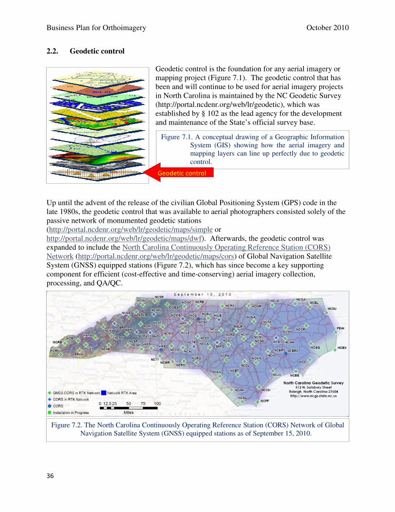
Business Plan for Orthoimagery October 2010
36
2.2. Geodetic control
Geodetic control is the foundation for any aerial imagery or mapping project (Figure 7.1). The geodetic control that has been and will continue to be used for aerial imagery projects in North Carolina is maintained by the NC Geodetic Survey (http://portal.ncdenr.org/web/lr/geodetic), which was established by § 102 as the lead agency for the development and maintenance of the State’s official survey base.
Up until the advent of the release of the civilian Global Positioning System (GPS) code in the late 1980s, the geodetic control that was available to aerial photographers consisted solely of the passive network of monumented geodetic stations (http://portal.ncdenr.org/web/lr/geodetic/maps/simple or http://portal.ncdenr.org/web/lr/geodetic/maps/dwf). Afterwards, the geodetic control was expanded to include the North Carolina Continuously Operating Reference Station (CORS) Network (http://portal.ncdenr.org/web/lr/geodetic/maps/cors) of Global Navigation Satellite System (GNSS) equipped stations (Figure 7.2), which has since become a key supporting component for efficient (cost-effective and time-conserving) aerial imagery collection, processing, and QA/QC.
Figure 7.2. The North Carolina Continuously Operating Reference Station (CORS) Network of Global Navigation Satellite System (GNSS) equipped stations as of September 15, 2010.
Figure 7.1. A conceptual drawing of a Geographic Information System (GIS) showing how the aerial imagery and mapping layers can line up perfectly due to geodetic control.
Geodetic control
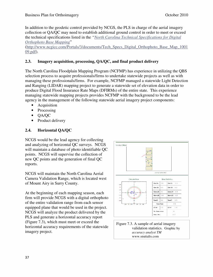
Business Plan for Orthoimagery October 2010
37
In addition to the geodetic control provided by NCGS, the PLS in charge of the aerial imagery collection or QA/QC may need to establish additional ground control in order to meet or exceed the technical specifications listed in the “North Carolina Technical Specifications for Digital Orthophoto Base Mapping” (http://www.ncgicc.com/Portals/3/documents/Tech_Specs_Digital_Orthophoto_Base_Map_100109.pdf). 2.3. Imagery acquisition, processing, QA/QC, and final product delivery
The North Carolina Floodplain Mapping Program (NCFMP) has experience in utilizing the QBS selection process to acquire professionals/firms to undertake statewide projects as well as with managing these professionals/firms. For example, NCFMP managed a statewide Light Detection and Ranging (LIDAR) mapping project to generate a statewide set of elevation data in order to produce Digital Flood Insurance Rate Maps (DFIRMs) of the entire state. This experience managing statewide mapping projects provides NCFMP with the background to be the lead agency in the management of the following statewide aerial imagery project components:
• Acquisition
• Processing
• QA/QC
• Product delivery 2.4. Horizontal QA/QC NCGS would be the lead agency for collecting and analyzing of horizontal QC surveys. NCGS will maintain a database of photo identifiable QC points. NCGS will supervise the collection of new QC points and the generation of final QC reports. NCGS will maintain the North Carolina Aerial Camera Validation Range, which is located west of Mount Airy in Surry County. At the beginning of each mapping season, each firm will provide NCGS with a digital orthophoto of the entire validation range from each sensor equipped plane that would be used in the project. NCGS will analyze the product delivered by the PLS and generate a horizontal accuracy report (Figure 7.3), which must meet or exceed the horizontal accuracy requirements of the statewide imagery project.
Figure 7.3. A sample of aerial imagery validation statistics. Graphic by accuracy analyst TM www.spatialis.com
Business Plan for Orthoimagery October 2010
38
2.5. Data storage and user access to imagery
The North Carolina Center for Geographic Information and Analysis (CGIA) will serve as the lead agency for data distribution and access to online imagery for state and federal agencies, local governments, and the private sector. An appropriate and cost-effective technology for storing, serving, and distributing the data products will be a key element of the overall project. Information technology improvements and workflows developed for the 2010 statewide project will benefit future projects. 2.6. Outreach to users
Outreach is a key element of any large (statewide) project. Many requests for information about the project will be received from the public and private sectors. CGIA will provide outreach in the form of presentations at conferences and other public events along with:
• Maintaining a project web page, such as the one for the 2010 Statewide Orthoimagery project (http://www.nconemap.net/NCOrthos/tabid/425/Default.aspx)
• Materials such as the “Examples of how aerial imagery is used in North Carolina” (http://www.nconemap.com/Portals/7/documents/NCOneMapExamImagery1007.pdf)
3. Technical support
The Working Group for Orthophotography Planning (http://www.ncgicc.com/Default.aspx?tabid=143) in the GICC State Mapping Advisory Committee (SMAC) would provide support to the project partners. Members of the committee include representatives from the following departments and agencies:
• North Carolina Center for Geographic Information and Analysis (CGIA)
• North Carolina Department of Agriculture & Consumer Services (NCDA&CS)
• North Carolina Department of Environment and Natural Resources (NCDENR) o Information Technology Services o North Carolina Geodetic Survey (NCGS)
• North Carolina Department of Transportation (NCDOT) Photogrammetry Unit
• North Carolina Department of the Secretary of State
• North Carolina Floodplain Mapping Program (NCFMP)
• United States Geological Survey (USGS)
• Local Government Committee (county or city GIS representative) The depth of knowledge and expertise from this committee has been and will continue to be a valuable asset to partnering agencies working on orthoimagery projects.

Business Plan for Orthoimagery October 2010
39
8. Project Funding
A. Project funding approaches
As noted in the Background section of this document, North Carolina has leveraged a variety of techniques to fund aerial imagery in the last ten years. Funding for these aerial imagery projects has included the following funding combinations:
• Cost-sharing between a state agency (CGIA) and counties using a combination of federal (cooperative agreements to reimburse for data sharing) and local funds
• Funding provided by a state agency (NCFMP) for full county projects
• Cost-sharing between state agencies [NCFMP and the North Carolina Geological Survey (NCGS) - Landslide Program] and local governments
• Grant from the North Carolina 911 Board for the full cost
• County funding alone without cost-share
• Public/private partnerships (city or county funding supplemented by electric power utility or water/sewer authority funding)
All approaches, except for the 911 grant, resulted in the collection of imagery in a piecemeal manner across the state. Yet, the most cost-efficient and effective method is to utilize a statewide data collection approach as succinctly described in the following excerpt from the NC OneMap Strategic Plan (2004):
Digital aerial imagery forms the foundation for other data layers. It is a significant cost item, but also a key asset. A new, integrated and cost effective approach is proposed to achieve a more current statewide data layer. The approach is to fly the photography to a GICC-approved standard for 25% of North Carolina every four years using a 50/50 cost share between the State of North Carolina and local governments. Historically, local governments have borne 100% of this cost. Some local governments have not been able to afford this expense at all. This new approach will ensure that complete statewide coverage is refreshed on a four-year cycle. This is important as North Carolina grows and changes over time. Decisions that will affect local communities or the state tomorrow need to be based on current data. The cost of digital aerial imagery is $2.5 million per year under this new approach.
Note that the cost figure is dated and would be on the order of $1.5 million per year in state share based on $3 million per year or a total cost of $12 million over four years. The 50/50 cost-share suggestion was a goal based on acknowledgement of widespread benefits of orthoimagery available on a statewide basis. After 2004, cost-share percentages for county by county projects ranged from about 10 to 25 percent from federal sources, and 50 to 100 percent from state sources. In practice, specific cost shares are difficult to predict in the context of funding sources with variable amounts year to year, variations in costs for private contracting, restrictions on programs based on location, and other factors.
Business Plan for Orthoimagery October 2010
40
B. Investment in accuracy
The 2010 project included investment in geodetic control to support horizontal accuracy of orthoimagery. A sustainable, effective program requires maintenance of those investments, particularly NC Continuously Operating Reference Stations (CORS) that are part of the North Carolina Real Time Network. The NC CORS is a cost-effective and time-conserving component of aerial imagery collection, processing, and quality assurance/quality control. North Carolina Geodetic Survey develops and maintains the Official Survey Base (GS 102) which includes passive monuments and CORS.
C. Project funding sources
Although funds for future statewide projects have not been identified, potential funding sources for statewide orthoimagery include the following:
• NC 911 Board funded a grant to the City of Durham for the 2010 statewide project. In 2010, the General Assembly authorized the Board to fund statewide projects directly.
• Floodplain Mapping Program in the Geospatial and Technology Management Office (GTM), Department of Crime Control and Public Safety. GTM has shared ortho imagery costs with selected counties in support of floodplain map maintenance that requires imagery not more than five years old.
• NC Geological Survey (NCGS) shared imagery cost with the Floodplain Mapping Program and local governments to support landslide mapping.
• US Geological Survey (USGS) National Geospatial Program and the National Geospatial Intelligence Agency (NGA) have provided partial funding of local orthoimagery under cooperative agreements with CGIA as part of the National Geospatial Program.
• The National Oceanic and Atmospheric Administration (NOAA) has funded coastal imagery projects in North Carolina.
• NC Department of Agriculture and Consumer Services (NCDACS) and the Department of Environment and Natural Resources (DENR) shared costs for imagery (leaf-on 1-meter resolution imagery) in support of agriculture. The US Department of Agriculture is the primary funding source the imagery (National Agriculture Imagery Program).
• Counties and cities. Until 2010, counties and cities supplied the majority of funding for orthoimagery.
• Public/private partnerships. As examples, municipal utilities and electric cooperatives have shared imagery costs in some counties.
Since 2005, the US Geological Survey (USGS), along with the National Geospatial Intelligence Agency (NGA) and the Department of Homeland Security (DHS) has invested $1,429,300 in partnership funding into the state for distribution to local governments in the collection and sharing of high resolution ortho imagery. Sixty-two (62) of the one hundred (100) counties in the state have taken advantage of this cost share program. The imagery and support files were shared by the local governments with the state and the USGS and placed into the public domain. Data is available thru NC OneMap and The National Map. NGA and DHS additionally used these data as assets for homeland security and hazard mitigation and response.
Business Plan for Orthoimagery October 2010
41
As events at the USGS have prompted change in the data requirements of the agency, the level of funding from USGS for ortho collection has declined. USGS funding is moving toward an elevation/LIDAR collection scenario starting in FY 2011 with fewer funds for ortho collection available. NGA continues having ortho data collection requirements for the NGA-defined urban areas of one hundred thirty-three (133) cities in the US, of which three (3), Winston-Salem/Greensboro, Raleigh/Durham, and Charlotte are in North Carolina. It is expected that NGA will continue to provide collaborative funding for these three urban areas for the foreseeable future. Note that some of the funding sources (e.g., Floodplain Mapping Program, USGS, NC Geological Survey, NC Department of Agriculture and Consumer Services) are restricted to projects in areas of the state that meet their agency policies or funding requirements. Those agencies cannot be the sole source of funding for a statewide acquisition project, but could provide supplemental funding for a statewide project when the acquisition of imagery meets their business requirements.
D. Recommended funding approach for future projects
Ideally, an organization would contribute to a statewide orthoimagery program in an amount that reflects the benefits of orthoimagery to its own business processes and to its clients and constituents. Benefits include savings of time, money and even lives, as well as qualitative benefits of better informed decisions about real estate, transportation, flood insurance, forest management, and land conservation to name a few. See Section 4, Program Benefits, above for more description of imagery benefits. Without attempting to quantify and assign benefits to specific organizations and their clients, a review of benefits sheds light on a funding approach. Substantial benefits for local government operations and local clients are evident when new, high resolution becomes available. Additional benefits, especially to emergency operations, are generated locally where there is imagery that is complete, consistent and concurrent across county boundaries. Statewide organizations benefit from statewide or at least regional imagery in numerous cross-jurisdictional areas of interest. Likewise, federal agencies benefit from the consistency and currency in a variety of applications. In addition, private organizations increasingly make use of orthoimagery in business processes. Funding for a statewide orthoimagery program after 2010 depends on budgeting, planning, negotiating, and factors that may not be apparent in 2010. As a framework, the recommended funding approach for the statewide program (including imagery acquisition, data access, program management and investment in geodetic control) is to work with the following groups to obtain funding that will support the recommendations contained in this plan:
1. Statewide organizations, including the NC 911 Board on behalf of local operations, and state departments that apply geospatial data to business processes. Specific amounts depend on project locations in relation to state program requirements, restrictions, timing and budgets.
Business Plan for Orthoimagery October 2010
42
2. Federal organizations, including cooperative agreements led by the National Geospatial Program. Funding from federal organizations depends on project locations, federal program initiatives and requirements, availability of funds, and limitations based on location and purpose.
3. Local governments. Specific amounts depend on project locations in relation to local program requirements and availability of funds.
4. Private organizations, including electric power utilities. In partnership with public entities, private organizations are potential sources for cost-share in selected counties where those organizations have business requirements for current high resolution imagery.
Business Plan for Orthoimagery October 2010
43
9. Implementation Plan
In 2011, North Carolina will be in the process of completing the statewide project with imagery flown in 2010. Tasks include distributing datasets to counties, providing online access to imagery, and assuring quality and data sharing early in 2011. Reports on the 2010 statewide orthoimagery project early in 2011, including lessons learned, will inform strategies of the NC Geographic Information Coordinating Council for 2012 and after. Based on the best available information and the considerations of the Working Group for Orthophotography Planning, the Statewide Mapping Advisory Committee, recommends an approach for future years, subject to support by potential funding sources and endorsement by the GICC. The Working Group for Orthophotography Planning considered a second statewide orthoimagery project as well as logical groupings of counties for alternative acquisition approaches. The options are full state, acquiring one-half of the state at time, flying the state in thirds, and flying the state in quarters. For each option, the group identified advantages and disadvantages.
A. Optional Approaches to Imagery Acquisition for the Statewide Program
1. Option 1 is a second statewide, 100-county project would occur by 2014 to satisfy the requirement that imagery not be more than four years old. The Working Group identified the following advantages of another statewide project:
a. The imagery provides a comprehensive, consistent base map for visual reference, geospatial reference, and geospatial analysis. Users would have confidence in currency and quality from tile to tile. For 911 operations, users benefit from consistent, predictable, current base mapping across jurisdictions, including ortho imagery.
b. The new set of imagery could be compared to the 2010 imagery to analyze changes in features anywhere in the state. Analyses such as land cover classification are most effective using a statewide dataset and having two time periods of comparable data.
c. Statewide delivery is equitable from the county perspective (all receive the same products) and predictable for planning purposes.
d. Users have maximum flexibility in defining areas of interest across jurisdictions and viewing images of the same currency.
e. Economies of scale are maximized by long flight lines for aerial acquisition, flexibility in defining aerial triangulation blocks across jurisdictions, common contracting covering all jurisdictions, common invoicing, common product specifications, and common deliverables.
f. A statewide project is a significant economic stimulus during the flight year. g. The most qualified contractors for a large multi-county project are likely to have
resources available to meet project requirements for the selected year. The Working Group identified several disadvantages to a full statewide project:
a. There is a heightened risk of leaves emerging in western areas before flights capture imagery in the context of statewide acquisition and deployment of numerous aircraft.
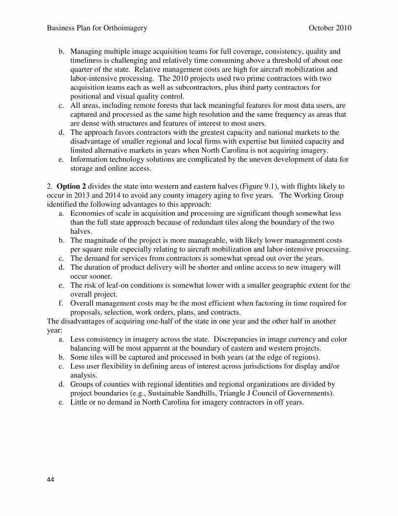
Business Plan for Orthoimagery October 2010
44
b. Managing multiple image acquisition teams for full coverage, consistency, quality and timeliness is challenging and relatively time consuming above a threshold of about one quarter of the state. Relative management costs are high for aircraft mobilization and labor-intensive processing. The 2010 projects used two prime contractors with two acquisition teams each as well as subcontractors, plus third party contractors for positional and visual quality control.
c. All areas, including remote forests that lack meaningful features for most data users, are captured and processed as the same high resolution and the same frequency as areas that are dense with structures and features of interest to most users.
d. The approach favors contractors with the greatest capacity and national markets to the disadvantage of smaller regional and local firms with expertise but limited capacity and limited alternative markets in years when North Carolina is not acquiring imagery.
e. Information technology solutions are complicated by the uneven development of data for storage and online access.
2. Option 2 divides the state into western and eastern halves (Figure 9.1), with flights likely to occur in 2013 and 2014 to avoid any county imagery aging to five years. The Working Group identified the following advantages to this approach:
a. Economies of scale in acquisition and processing are significant though somewhat less than the full state approach because of redundant tiles along the boundary of the two halves.
b. The magnitude of the project is more manageable, with likely lower management costs per square mile especially relating to aircraft mobilization and labor-intensive processing.
c. The demand for services from contractors is somewhat spread out over the years. d. The duration of product delivery will be shorter and online access to new imagery will
occur sooner. e. The risk of leaf-on conditions is somewhat lower with a smaller geographic extent for the
overall project. f. Overall management costs may be the most efficient when factoring in time required for
proposals, selection, work orders, plans, and contracts. The disadvantages of acquiring one-half of the state in one year and the other half in another year:
a. Less consistency in imagery across the state. Discrepancies in image currency and color balancing will be most apparent at the boundary of eastern and western projects.
b. Some tiles will be captured and processed in both years (at the edge of regions). c. Less user flexibility in defining areas of interest across jurisdictions for display and/or
analysis. d. Groups of counties with regional identities and regional organizations are divided by
project boundaries (e.g., Sustainable Sandhills, Triangle J Council of Governments). e. Little or no demand in North Carolina for imagery contractors in off years.
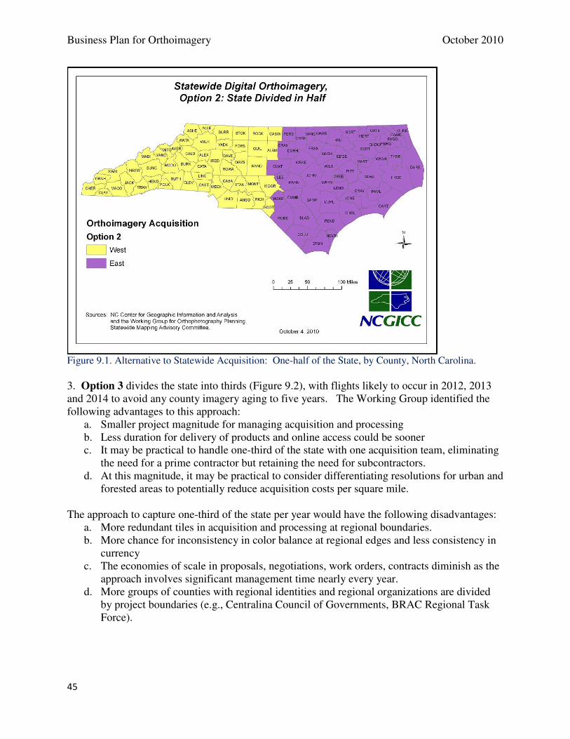
Business Plan for Orthoimagery October 2010
45
Figure 9.1. Alternative to Statewide Acquisition: One-half of the State, by County, North Carolina. 3. Option 3 divides the state into thirds (Figure 9.2), with flights likely to occur in 2012, 2013 and 2014 to avoid any county imagery aging to five years. The Working Group identified the following advantages to this approach:
a. Smaller project magnitude for managing acquisition and processing b. Less duration for delivery of products and online access could be sooner c. It may be practical to handle one-third of the state with one acquisition team, eliminating
the need for a prime contractor but retaining the need for subcontractors. d. At this magnitude, it may be practical to consider differentiating resolutions for urban and
forested areas to potentially reduce acquisition costs per square mile. The approach to capture one-third of the state per year would have the following disadvantages:
a. More redundant tiles in acquisition and processing at regional boundaries. b. More chance for inconsistency in color balance at regional edges and less consistency in
currency c. The economies of scale in proposals, negotiations, work orders, contracts diminish as the
approach involves significant management time nearly every year. d. More groups of counties with regional identities and regional organizations are divided
by project boundaries (e.g., Centralina Council of Governments, BRAC Regional Task Force).
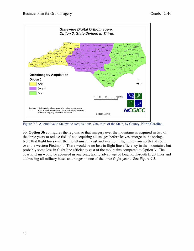
Business Plan for Orthoimagery October 2010
46
Figure 9.2. Alternative to Statewide Acquisition: One-third of the State, by County, North Carolina. 3b. Option 3b configures the regions so that imagery over the mountains is acquired in two of the three years to reduce risk of not acquiring all images before leaves emerge in the spring. Note that flight lines over the mountains run east and west, but flight lines run north and south over the western Piedmont. There would be no loss in flight line efficiency in the mountains, but probably some loss in flight line efficiency east of the mountains compared to Option 3. The coastal plain would be acquired in one year, taking advantage of long north-south flight lines and addressing all military bases and ranges in one of the three flight years. See Figure 9.3.
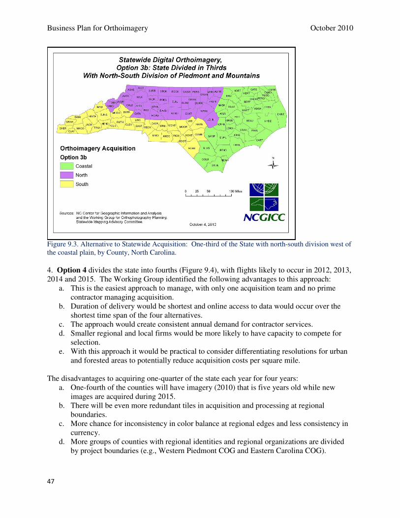
Business Plan for Orthoimagery October 2010
47
Figure 9.3. Alternative to Statewide Acquisition: One-third of the State with north-south division west of the coastal plain, by County, North Carolina. 4. Option 4 divides the state into fourths (Figure 9.4), with flights likely to occur in 2012, 2013, 2014 and 2015. The Working Group identified the following advantages to this approach:
a. This is the easiest approach to manage, with only one acquisition team and no prime contractor managing acquisition.
b. Duration of delivery would be shortest and online access to data would occur over the shortest time span of the four alternatives.
c. The approach would create consistent annual demand for contractor services. d. Smaller regional and local firms would be more likely to have capacity to compete for
selection. e. With this approach it would be practical to consider differentiating resolutions for urban
and forested areas to potentially reduce acquisition costs per square mile. The disadvantages to acquiring one-quarter of the state each year for four years:
a. One-fourth of the counties will have imagery (2010) that is five years old while new images are acquired during 2015.
b. There will be even more redundant tiles in acquisition and processing at regional boundaries.
c. More chance for inconsistency in color balance at regional edges and less consistency in currency.
d. More groups of counties with regional identities and regional organizations are divided by project boundaries (e.g., Western Piedmont COG and Eastern Carolina COG).
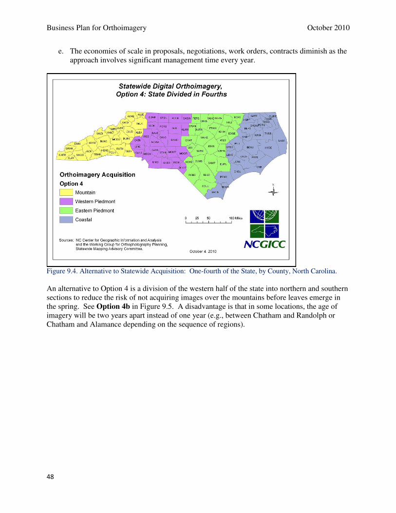
Business Plan for Orthoimagery October 2010
48
e. The economies of scale in proposals, negotiations, work orders, contracts diminish as the approach involves significant management time every year.
Figure 9.4. Alternative to Statewide Acquisition: One-fourth of the State, by County, North Carolina. An alternative to Option 4 is a division of the western half of the state into northern and southern sections to reduce the risk of not acquiring images over the mountains before leaves emerge in the spring. See Option 4b in Figure 9.5. A disadvantage is that in some locations, the age of imagery will be two years apart instead of one year (e.g., between Chatham and Randolph or Chatham and Alamance depending on the sequence of regions).
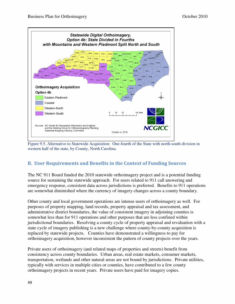
Business Plan for Orthoimagery October 2010
49
Figure 9.5. Alternative to Statewide Acquisition: One-fourth of the State with north-south division in western half of the state, by County, North Carolina.
B. User Requirements and Benefits in the Context of Funding Sources
The NC 911 Board funded the 2010 statewide orthoimagery project and is a potential funding source for sustaining the statewide approach. For users related to 911 call answering and emergency response, consistent data across jurisdictions is preferred. Benefits to 911 operations are somewhat diminished where the currency of imagery changes across a county boundary. Other county and local government operations are intense users of orthoimagery as well. For purposes of property mapping, land records, property appraisal and tax assessment, and administrative district boundaries, the value of consistent imagery in adjoining counties is somewhat less than for 911 operations and other purposes that are less confined within jurisdictional boundaries. Resolving a county cycle of property appraisal and revaluation with a state cycle of imagery publishing is a new challenge where county-by-county acquisition is replaced by statewide projects. Counties have demonstrated a willingness to pay for orthoimagery acquisition, however inconsistent the pattern of county projects over the years. Private users of orthoimagery (and related maps of properties and streets) benefit from consistency across county boundaries. Urban areas, real estate markets, consumer markets, transportation, wetlands and other natural areas are not bound by jurisdictions. Private utilities, typically with services in multiple cities or counties, have contributed to a few county orthoimagery projects in recent years. Private users have paid for imagery copies.
Business Plan for Orthoimagery October 2010
50
State and federal agencies, who have shared a portion of the cost of county imagery projects in 88 of 100 counties, benefit most from concurrent datasets that may be applied to multi-county areas, river basins, habitats, highway corridors, and other areas of interest that go beyond the boundaries of a single county.
C. Recommendations for Implementation of Future Projects
For the purpose of generating the most benefits for users of orthoimagery in North Carolina, the Statewide Mapping Advisory Committee recommends the following approach to imagery acquisition, funding, and program management. Imagery Acquisition
For statewide imagery acquisition, the SMAC recommends Option 4b which divides the state into fourths, with flights beginning in 2012, and additional flights in 2013, 2014 and 2015. See Figure 9.6. The Working Group identified the following advantages to this approach:
a. This is the most efficient management approach, requiring only one acquisition team. There would not be a need for a prime contractor to manage multiple acquisition teams.
b. Duration of delivery would be shortest and online access to data would occur over the shortest time span of the four alternatives.
c. The approach would create consistent annual demand for contractor services. d. Smaller regional and local firms would be more likely to have capacity to compete for
selection. e. With this approach it would be practical to consider differentiating resolutions for urban
and forested areas to potentially reduce acquisition costs per square mile. f. The division of the western region into north and south project areas reduces the risk of
not acquiring images over the mountains before leaves emerge in the spring. Implementation of the business plan will sustain a statewide program and its widespread benefits to users across North Carolina.
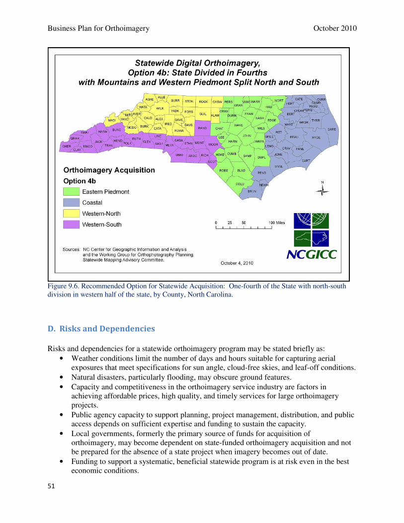
Business Plan for Orthoimagery October 2010
51
Figure 9.6. Recommended Option for Statewide Acquisition: One-fourth of the State with north-south division in western half of the state, by County, North Carolina.
D. Risks and Dependencies
Risks and dependencies for a statewide orthoimagery program may be stated briefly as:
• Weather conditions limit the number of days and hours suitable for capturing aerial exposures that meet specifications for sun angle, cloud-free skies, and leaf-off conditions.
• Natural disasters, particularly flooding, may obscure ground features.
• Capacity and competitiveness in the orthoimagery service industry are factors in achieving affordable prices, high quality, and timely services for large orthoimagery projects.
• Public agency capacity to support planning, project management, distribution, and public access depends on sufficient expertise and funding to sustain the capacity.
• Local governments, formerly the primary source of funds for acquisition of orthoimagery, may become dependent on state-funded orthoimagery acquisition and not be prepared for the absence of a state project when imagery becomes out of date.
• Funding to support a systematic, beneficial statewide program is at risk even in the best economic conditions.
Business Plan for Orthoimagery October 2010
52
10. APPENDICES
A. Key Participants and Stakeholders in an Orthoimagery Program B. Business Requirements for Storage and Access to Interim Imagery Files C. Imagery Data Formats and Methods for Delivery and Access
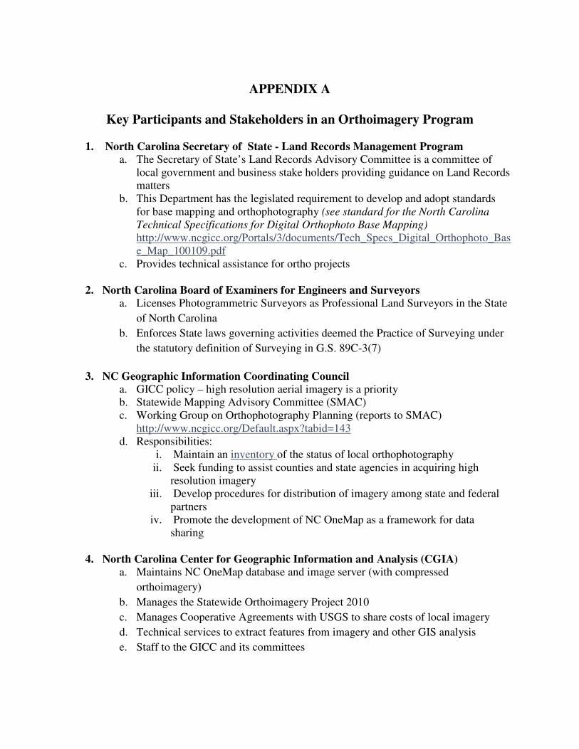
APPENDIX A
Key Participants and Stakeholders in an Orthoimagery Program
1. North Carolina Secretary of State - Land Records Management Program
a. The Secretary of State’s Land Records Advisory Committee is a committee of local government and business stake holders providing guidance on Land Records matters
b. This Department has the legislated requirement to develop and adopt standards for base mapping and orthophotography (see standard for the North Carolina Technical Specifications for Digital Orthophoto Base Mapping) http://www.ncgicc.org/Portals/3/documents/Tech_Specs_Digital_Orthophoto_Base_Map_100109.pdf
c. Provides technical assistance for ortho projects
2. North Carolina Board of Examiners for Engineers and Surveyors
a. Licenses Photogrammetric Surveyors as Professional Land Surveyors in the State
of North Carolina
b. Enforces State laws governing activities deemed the Practice of Surveying under
the statutory definition of Surveying in G.S. 89C-3(7)
3. NC Geographic Information Coordinating Council
a. GICC policy – high resolution aerial imagery is a priority b. Statewide Mapping Advisory Committee (SMAC) c. Working Group on Orthophotography Planning (reports to SMAC)
http://www.ncgicc.org/Default.aspx?tabid=143 d. Responsibilities:
i. Maintain an inventory of the status of local orthophotography ii. Seek funding to assist counties and state agencies in acquiring high
resolution imagery iii. Develop procedures for distribution of imagery among state and federal
partners iv. Promote the development of NC OneMap as a framework for data
sharing
4. North Carolina Center for Geographic Information and Analysis (CGIA)
a. Maintains NC OneMap database and image server (with compressed
orthoimagery)
b. Manages the Statewide Orthoimagery Project 2010
c. Manages Cooperative Agreements with USGS to share costs of local imagery
d. Technical services to extract features from imagery and other GIS analysis
e. Staff to the GICC and its committees
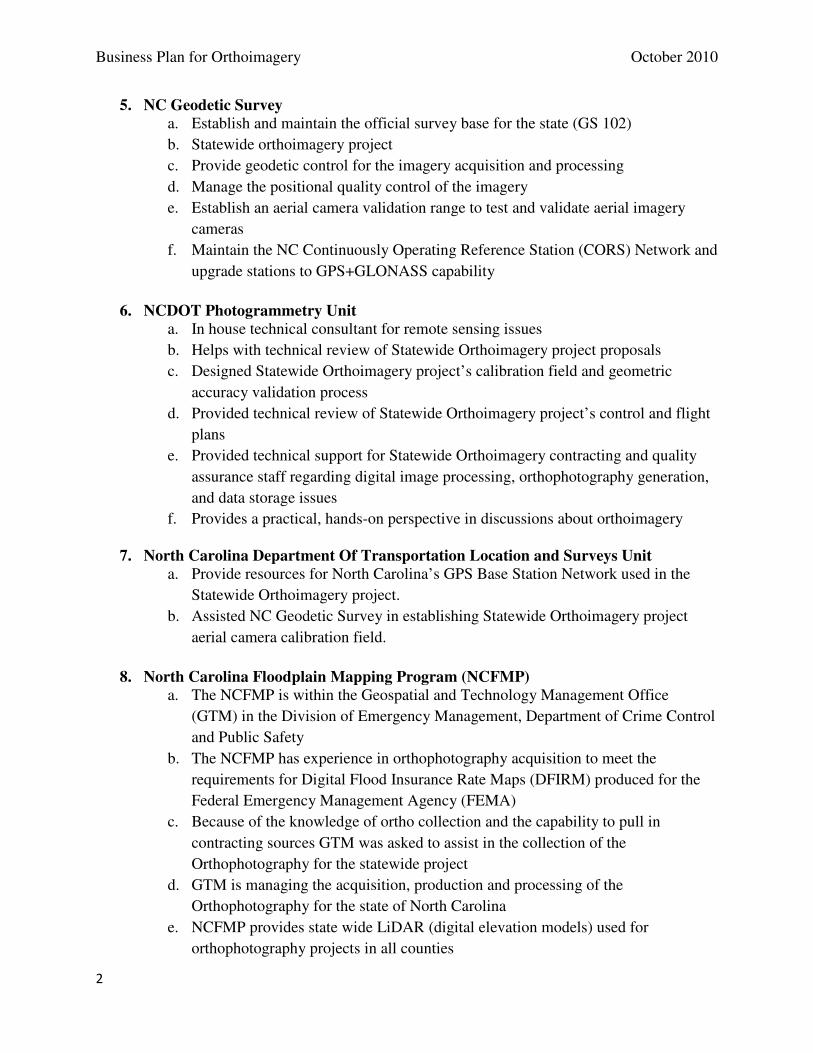
Business Plan for Orthoimagery October 2010
2
5. NC Geodetic Survey
a. Establish and maintain the official survey base for the state (GS 102)
b. Statewide orthoimagery project
c. Provide geodetic control for the imagery acquisition and processing
d. Manage the positional quality control of the imagery
e. Establish an aerial camera validation range to test and validate aerial imagery
cameras
f. Maintain the NC Continuously Operating Reference Station (CORS) Network and
upgrade stations to GPS+GLONASS capability
6. NCDOT Photogrammetry Unit
a. In house technical consultant for remote sensing issues
b. Helps with technical review of Statewide Orthoimagery project proposals
c. Designed Statewide Orthoimagery project’s calibration field and geometric
accuracy validation process
d. Provided technical review of Statewide Orthoimagery project’s control and flight
plans
e. Provided technical support for Statewide Orthoimagery contracting and quality
assurance staff regarding digital image processing, orthophotography generation,
and data storage issues
f. Provides a practical, hands-on perspective in discussions about orthoimagery
7. North Carolina Department Of Transportation Location and Surveys Unit
a. Provide resources for North Carolina’s GPS Base Station Network used in the
Statewide Orthoimagery project.
b. Assisted NC Geodetic Survey in establishing Statewide Orthoimagery project
aerial camera calibration field.
8. North Carolina Floodplain Mapping Program (NCFMP)
a. The NCFMP is within the Geospatial and Technology Management Office
(GTM) in the Division of Emergency Management, Department of Crime Control
and Public Safety
b. The NCFMP has experience in orthophotography acquisition to meet the
requirements for Digital Flood Insurance Rate Maps (DFIRM) produced for the
Federal Emergency Management Agency (FEMA)
c. Because of the knowledge of ortho collection and the capability to pull in
contracting sources GTM was asked to assist in the collection of the
Orthophotography for the statewide project
d. GTM is managing the acquisition, production and processing of the
Orthophotography for the state of North Carolina
e. NCFMP provides state wide LiDAR (digital elevation models) used for
orthophotography projects in all counties
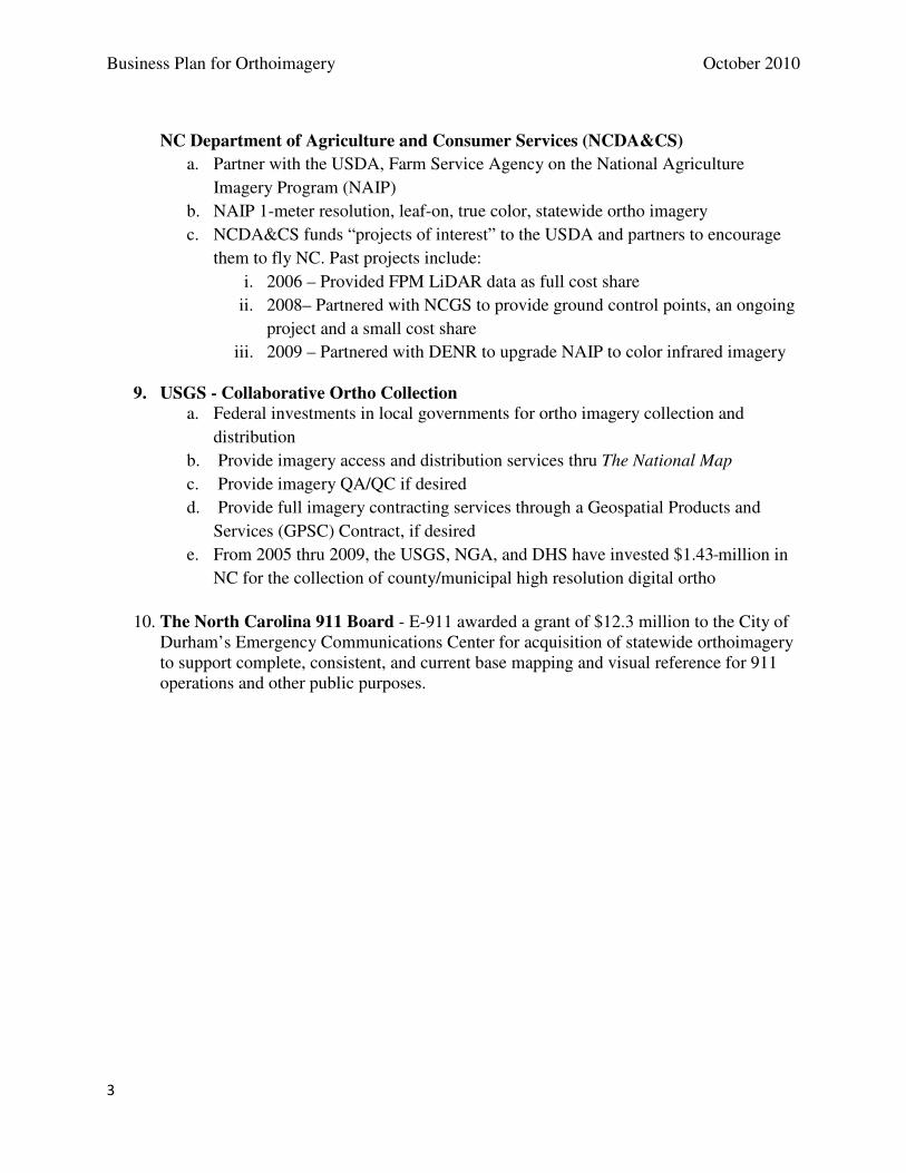
Business Plan for Orthoimagery October 2010
3
NC Department of Agriculture and Consumer Services (NCDA&CS)
a. Partner with the USDA, Farm Service Agency on the National Agriculture
Imagery Program (NAIP)
b. NAIP 1-meter resolution, leaf-on, true color, statewide ortho imagery
c. NCDA&CS funds “projects of interest” to the USDA and partners to encourage
them to fly NC. Past projects include:
i. 2006 – Provided FPM LiDAR data as full cost share
ii. 2008– Partnered with NCGS to provide ground control points, an ongoing
project and a small cost share
iii. 2009 – Partnered with DENR to upgrade NAIP to color infrared imagery
9. USGS - Collaborative Ortho Collection
a. Federal investments in local governments for ortho imagery collection and
distribution
b. Provide imagery access and distribution services thru The National Map
c. Provide imagery QA/QC if desired
d. Provide full imagery contracting services through a Geospatial Products and
Services (GPSC) Contract, if desired
e. From 2005 thru 2009, the USGS, NGA, and DHS have invested $1.43 million in
NC for the collection of county/municipal high resolution digital ortho
10. The North Carolina 911 Board - E-911 awarded a grant of $12.3 million to the City of
Durham’s Emergency Communications Center for acquisition of statewide orthoimagery to support complete, consistent, and current base mapping and visual reference for 911 operations and other public purposes.
APPENDIX B
Business Requirements for Storage and Access to Interim Imagery Files
The Working Group identified potential benefits from imagery data that has been processed to an interim stage where it is ready for “exploitation” into orthorectified images. From that interim product, specialists may generate 3D imagery, color infrared imagery (using the fourth band that is not used in the true color products), and topographic products. Storage and access to interim imagery files were not deliverables in the 2010 statewide project. However, the Working Group developed a description and approach.
Interim Imagery Files
For the Statewide 2010 project, contractors to the Department of Crime Control and Public Safety’s Geospatial and Technology Management Office are processing raw exposures from the digital aerial cameras into 4-band interim imagery files. This intermediate data is staged for further processing that ties the aerial pictures to the earth. At the semi-processed stage, the data is suitable for true color imagery production, color infrared imagery production, or both.
Potential Users
Users (or their contractors) who have the resources to generate color infrared orthoimagery may include:
• Self-selected counties (typically engaging licensed photogrammetry services)
• State agencies, especially those related to environment, natural resources, and agriculture
• Federal agencies, especially those related to natural sciences and earth observation
• University researchers related to the topics above
• Nongovernmental organizations, especially those related to land conservation, water quality and wildlife habitat
• Private businesses, especially those related to engineering, planning and environmental services
Applications
How would users apply color infrared imagery to their business processes? The North Carolina Center for Geographic Information and Analysis (CGIA) has done service projects for many of the typical applications including land cover analysis, impervious surface mapping, tree canopy analysis, forest type analysis, urban forestry, and wetland mapping. How often would users require access to the semi-processed datasets? For a given county or region, successful processing of interim imagery to ortho-rectified color infrared imagery need occur only once if the product is placed in the public domain or shared with CGIA to for public distribution. It is unlikely that all counties and regions of the state will find users willing and able to cover the cost of processing color infrared imagery (costing as much as 50 percent of a typical orthoimagery project). The requests for data are likely to be 25 or fewer the first year, and a diminishing number in following years.

Business Plan for Orthoimagery October 2010
2
Benefits
If a county or other entity were to identify a need for 2010 color infrared imagery, commonly a contractor would be engaged to either use the interim imagery files or recreate them from raw exposures. Access to the interim files would save a contractor approximately 50 percent in total costs for generating products from the 4th band compared to starting with the raw exposures.
Storage Requirements
The interim imagery files are being downloaded to 2-TB portable drives for short-term retention. The approximate disk storage space equals 112 TB (based on 221,000 camera exposures statewide). Interim imagery files are organized by large geographic blocks that contain parts of multiple counties, not by tile like the finished orthoimagery or by county. Data for an average county extraction would amount to 2 TB.
Technical Solution
A solution for retention of the data is storage on a secure server, with no public interface. The only functionality required is access to the data to make copies of selected files to portable media in response to requests from local, state, federal and private entities subject to approval by the NC 911 Board. Data requests would require time for fulfilling requests, cost recovery for portable media used if not supplied by the requester of data, and recovery of shipping costs if any. Requests are expected to be infrequent and involve portions of the dataset. The amount of disk storage space would be 112 TB for this dataset.
APPENDIX C
Data Formats and Methods for Delivery and Access to Orthoimagery
Functional Requirements for Image Data Access
Imagery must be available for users to access in multiple formats and via multiple delivery mechanisms.
A single solution will not satisfy the needs of all users. Users of imagery in desktop software applications
have very different needs and expectations than users of web-based map viewers. Image Analysis and
GIS professionals have much more demanding requirements for data access than the general public. A
multi-faceted approach is required to accommodate the many different constituents of a “to-be”
comprehensive suite of image delivery solutions for NC OneMap.
Aerial or Satellite Imagery Formats:
• Uncompressed, full-resolution GeoTIFF format
• A highly compressed format (ECW, MrSID, JPEG 2000)
• Specialized formats for multi-spectral or multi-dimensional raster data
GeoTIFF is a public domain standard which allows georeferencing information to be embedded within a
TIFF image file. The information includes map projection, coordinate systems, ellipsoids, datums, and
everything else necessary to establish the exact spatial reference for the image file. This format is also the
most widely accessible by GIS, CAD and other visualization software, and it is considered the “industry
standard”. The GeoTIFF format is also capable of containing more than three spectral bands, making it
possible to display both the “True Color” (the Red/Green/Blue of visible light) format and “False Color
Infrared” (Red/Green/NearIR) format from the same file. Aerial photography is usually delivered from a
contractor in uncompressed GeoTIFF format. This is most commonly used image format for archival
purposes because it maintains full resolution and pixel fidelity. Tiff and GeoTIFF format images are
limited to file sizes of 4GB. There is a variant of the Tiff format known as “BigTiff” which can be
essentially unlimited in size, but for most applications, file sizes larger than 4GB are simply not practical.
The primary drawback to GeoTIFF format is its very large size. Although uncompressed GeoTIFF is
recommended as the master or archive image format, it is too large for general distribution via FTP or
other internet download mechanisms. It is typically needed only by GIS and/or Remote Sensing
professionals who perform imagery analysis operations requiring the complete spectral information
contained in each pixel. Internet map server applications also benefit from using uncompressed GeoTIFF
imagery as a data source. The software is able to read and process the pixel information much faster than
it would from a compressed image format, which generally must first be uncompressed before it can be
rendered. For use with internet map server applications, uncompressed GeoTIFF images may have
internal overviews built, which further speeds rendering and display speed. Internal overviews should not
be built on the master or archival copy of an imagery dataset.
Compressed image formats produce file sizes that are much smaller than the uncompressed GeoTIFF
version of an image, some with a small loss of image quality (lossy), and some without (lossless).
Wavelet compression techniques currently provide the highest compression mechanism commonly
available in most GIS and CAD software. As an example, a 200 MB 4-band DOQQ in uncompressed
Business Plan for Orthoimagery October 2010
2
GeoTIFF format may be compressed into a 20 MB ECW format image file with little or no discernable
loss in image quality. Compressed images are no longer suitable for true image analysis operations and
lose any extra band information, but are highly useful in all other mapping and visualization operations. A
highly compressed format is preferred for general distribution from FTP sites and LAN file servers alike.
Several lossless compression formats are currently in use in the GIS and CAD industry: ECW, MrSID,
and JPEG 2000.
ECW format (.ecw) is a proprietary, lossy wavelet compression image format that is optimized for aerial
and satellite imagery without using intermediate tiling or intermediate disk storage. Georeferencing
information is contained partially in the internal file header and partially in an external “world file”
(.wld). This format was originally developed by Earth Resource Mapping for its ERMapper software
product, but it has since been acquired by parent company ERDAS/Leica/Hexagon. While under ERM
ownership, a version of the ECW codec and software developer’s kit (SDK) to enable ECW image
decompression or creation (under 500 MB in size) was released for free usage by the GIS community.
Subsequently, many software applications began to include support for ECW format. After gaining
control of the format, ERDAS has made the current version of the ECW codec and SDK unavailable for
free public download and restricted its use to “evaluation purposes” only. This makes ECW a slightly less
desirable image format than it has been in the past, but it is still widely used and quite useful. GDAL, an
open source spatial data conversion toolkit, uses an older, “legal” version of the ERMapper ECW SDK
and is the primary means for creating ECW images (under 500 MB) without the purchase of an SDK or
other software license from ERDAS.
MrSID format (.sid) stands for “multi-resolution seamless image database”. It is a proprietary (lossy or
lossless) discrete wavelet compression image format originally developed at Los Alamos National
Laboratories. The technology was later privatized, with development and distribution rights owned by
LizardTech, Inc. and subsequently acquired by parent company Celartem Inc. Georeferencing
information is stored in external “world” files (.sdw) and the format supports multiple levels of internal
overviews that provide a fast, progressive display at many different “zoom levels”. There is no free or
open source implementation of the MrSID format, but most mainstream commercial GIS and CAD
software offers support for reading this format, both the “generation 2” (MG2) and “generation 3” (MG3)
versions. MG2 format is limited to 2GB in file size and supports only lossy compression. MG3 supports
unlimited file sizes, lossless encoding with optimization and manipulation functions such as area of
interest encoding. Open source GIS software based on the GDAL library has the ability to read MrSID
images. There is no free mechanism for encoding large images in the MrSID format, but the ArcMap
software includes the ability to encode individual, decompressed rasters smaller than 50 MB to the MrSid
format. This is useful only for aerial photography that covers a very small area. The ability to encode
images larger than 50MB requires the purchase of an SDK or other software license from LizardTech.
Regardless, the MrSID format remains a very popular aerial imagery format in the GIS industry.
JPEG 2000 is an image compression standard and coding system created by the Joint Photographic
Experts Group committee, with the intention of superseding their original JPEG standard with a superior
wavelet-based compression method. JPEG 2000 format decomposes an image into a multiple resolution
representation in the course of its compression process, supports tiling during the encoding process, and
progressive transmission when decoding and displaying an image. Cultural heritage organizations are
starting to use JPEG 2000 as an archival format because of its ability to preserve the original image
Business Plan for Orthoimagery October 2010
3
quality and characteristics without loss of fidelity, but uncompressed Tiff or GeoTIFF currently remain
the predominant archival format.
The Open Geospatial Consortium (OGC) has defined a metadata standard for georeferencing JPEG 2000
images with embedded XML using the Geography Markup Language (GML) format: GML in JPEG 2000
for Geographic Imagery Encoding (GMLJP2). JPEG 2000 files containing GMLJP2 markup are
“georeferenced” and can be located and displayed in the correct position on the Earth's surface by GIS
and CAD software that supports this format. One limitation of the JPEG 2000 standard is that it does not
specify how to mosaic an image with other data projected to some common coordinate system. Advanced
features of the GMLJP2 format include support for:
• Image bit-depths of 16 or higher
• Virtually unlimited number of spectral bands to support hyperspectral imagery
• Full cameras / sensor model descriptions
• Image quality information, such as cloud-cover estimates or NIIRS rating
• Multiple images (stereo pairs) stored within the same image file
There are a variety of codices and SDKs for encoding images in the JPEG 2000 format – some open
source, some not. The GIS industry has been much slower to adopt and support the JPEG 2000 format
because of inconsistencies between the interpretation of the standards for JPEG 2000 and in the image
output of different codecs. There has been a general lack of adoption for the format in the mainstream
image editing software industry as well. Currently, there is still no native support for JPEG 2000 in any of
the major web browsers, although there are plug-ins that enable limited JPEG 2000 browser support.
JPEG2000 has been more successful as an image format in mobile devices and communication
applications where very image high quality with minimal size is required.
Support for JPG2000 images is less than mature in the GIS industry, and not all software packages will
read all JPEG 2000 images yet. As an example, the 2008 Texas NAIP Imagery was distributed as JPEG
2000 files and was encoded using the kakadu JPEG2000 encoder. In an account of JPEG 2000 imagery
testing documented at http://blogs.onterrasystems.com/gisblog/?p=78 the JPEG 2000 images proved to
be unreadable by GDAL, ERViewer, TatukGIS, AutoCAD Map, and GeoJasper – all of which use the
ERMapper ECW/JPEG2000 SDK. Of the GIS/CAD applications tested by the reviewer, only ArcView
and GlobalMapper were capable of reading the JPEG 2000 images. While the JPEG 2000 format holds
promise to become a future preferred imagery format, the current lack of comprehensive software
package support for it and the inconsistent encoder implementations indicate that it is not yet ready to
become the preferred delivery format for aerial imagery.
Specialty Formats
Specialized formats for raster data derived from sensors on various satellite platforms, (Landsat, SPOT,
Aqua, Terra, Ikonos, etc.) often include multi-spectral or multi-dimensional data representations. There
are a multitude of file formats in use. Outside of the scientific communities, these specialty formats are
often encountered:
• Erdas Imagine (.img)
• ERMapper (.ers).
Business Plan for Orthoimagery October 2010
4
• Hierarchical Data Format for Earth Observing Systems (HDF-EOS)
• Network Common Data Form (netCDF)
IMG and ERS formats have enjoyed support in most GIS packages for some time. Increasingly, they have
begun offering support for netCDF and HDF, but often GIS practitioners convert the image, or the
relevant subset of a multi-dimensional image, to GeoTIFF for greater ease of use. None of these specialty
formats is suitable for use as a general data distribution format for North Carolina orthophotography.
There are also a wide variety of specialized imagery formats used by the US DoD and Federal
Intelligence Community, and most of these are seldom encountered in the civilian world. One exception
is NITF, or the National Imagery Transmission Format. It has been adopted as a standard by the
International Standards Organization and the American National Standards Institute (ISO/ANSI), as the
Basic Imagery Interchange Format (BIIF). BIIF is an implementation of JPEG 2000 Core Coding that has
been designed to support NATO and U.S. military applications. This format is capable of encapsulating
complex “metadata”, or information about the image, the image itself, as well as optional overlay
graphics (symbols, labels, and text) all in the same file package. While this format is becoming more
well-known in the civilian world, it is not yet common enough for consideration as a distribution format
in the North Carolina for public domain imagery.
A fairly new “specialty” format for use with aerial and satellite imagery is “New Universal Image” (nui).
This is a proprietary format developed by Pixia Corporation, primarily for the Department of Homeland
Security. The format is designed to provide very rapid retrieval, display, and manipulation of massive,
high-resolution image files without the need for image compression. The nui technology, while a potential
candidate for powering very fast, web-based image delivery and display services, is not yet widely
supported in mainstream GIS or CAD desktop software, and is too proprietary to use as a general
distribution format for public domain image files.
Image Format Recommendations
Master or archival copies of imagery should use uncompressed GeoTIFF image format. Image and remote
sensing analysts will also require imagery in uncompressed GeoTIFF, but this is a very small user group.
At some point in the future, lossless JPEG 2000 may become the preferred image format for archival or
analysis, but it is not a suitably mature and or consistently implemented format yet.
Recommended “general distribution” formats are ECW or MrSID format. Both offer much smaller files
than GeoTIFF images. They are generally well supported (at least for read operations) by most GIS and
CADD software packages. ECW is slightly more accessible, in that a number of the open source GIS
packages do not support MrSID format. ECW or MrSID format imagery is suitable for download on
public FTP sites.
Both ECW and MrSID formats are conducive to producing single-image mosaics of smaller and medium-
sized coverage areas (cities or counties) while still maintaining a reasonable file size. Users who need
larger coverage areas (river basins or full state) will be better served by imagery that has been tiled using
a rectangular grid, so that a seamless raster image catalog can created in their desktop software of choice.
The most common tiling system used with medium resolution imagery (ex: USDA NAIP with 1-2m pixel
resolution) is the USGS Digital Orthophoto Quarter Quad (DOQQ) grid. In this system, each image tile
Business Plan for Orthoimagery October 2010
5
dimension spans 3.25 minutes of longitude/latitude (~3.1 miles). For higher resolution aerial imagery,
such as the 6-inch to 1-foot pixel resolution imagery typically flown by county land records departments,
smaller tiles are more useful because the file sizes are larger. In North Carolina, the tiling system of
record is a 10,000-foot square “Basic Modular Unit “ mandated by the Technical Specifications for
Digital Orthophoto Base Mapping, as published by the NC Land Records Management Division of The
Secretary of State’s Office.
Imagery Delivery Mechanisms:
A variety of data delivery mechanisms are available, although many are not practical or advisable for
access to large image datasets, particularly “real-time” desktop access.
• CD / DVD media
• Portable Hard Drive and “Sneaker-Net”
• “Live” Network Access over a Local Area Network (LAN)
• “Live” Network Access over a Wide Area Network (WAN)
• Internet downloads using FTP / HTTP / WGET
• Bittorrent
• An OGC “Web Map Service” (WMS)
• An OGC “Web Map Tile Service” (WMTS)
• An OGC “Web Coverage Service” (WCS) “
• Globe” Servers
• Other Assorted Image Data Access Services
CD / DVD Media: Image distribution via this type of media is no longer very useful because of the
limited amount of data that can be stored on a single disc, and this method of data transfer works only for
very small jurisdictions or coverage areas.
Portable Hard Drive and “Sneaker-net”: Large county or statewide datasets in uncompressed GeoTIFF
format are typically shared with other organizations by loading a copy of the data on a portable hard
drive. “Sneaker-Net” is a tongue-in-cheek term used to describe the transfer of electronic information by
physically couriering removable media from one computer to another, in lieu of transferring the
information over a computer network. This is a fairly archaic mode of data delivery, but given the
bandwidth limitations most organizations still contend with, it is a reliable, inexpensive, and relatively
painless way to share data.
“Live” Network Access over a Local Area Network (LAN): Inside an organization, local workgroups
often place a single, read-only copy of an imagery dataset on a local file server and the many GIS staff all
access it over the local area network. Uncompressed GeoTIFF files are generally too large for this method
and data access times will be unusable on most networks, and can degrade the network unacceptably for
other general computing operations. Depending on the network connection speeds (10 Mbps vs 100
Mbps) access to compressed image formats such as ECW or MrSID may also be slower than desired by
the GIS users. One strategy for mitigating the problem is to place only the GIS users who need to access
the imagery on the same dedicated segment of the network as the image file server and ensure each user
has at least a 100 Mbps Ethernet connection. Gigabit Ethernet (1000 Mbps) is preferable, but not yet
widely available in all offices. This type of data access provides generally acceptable performance. If the
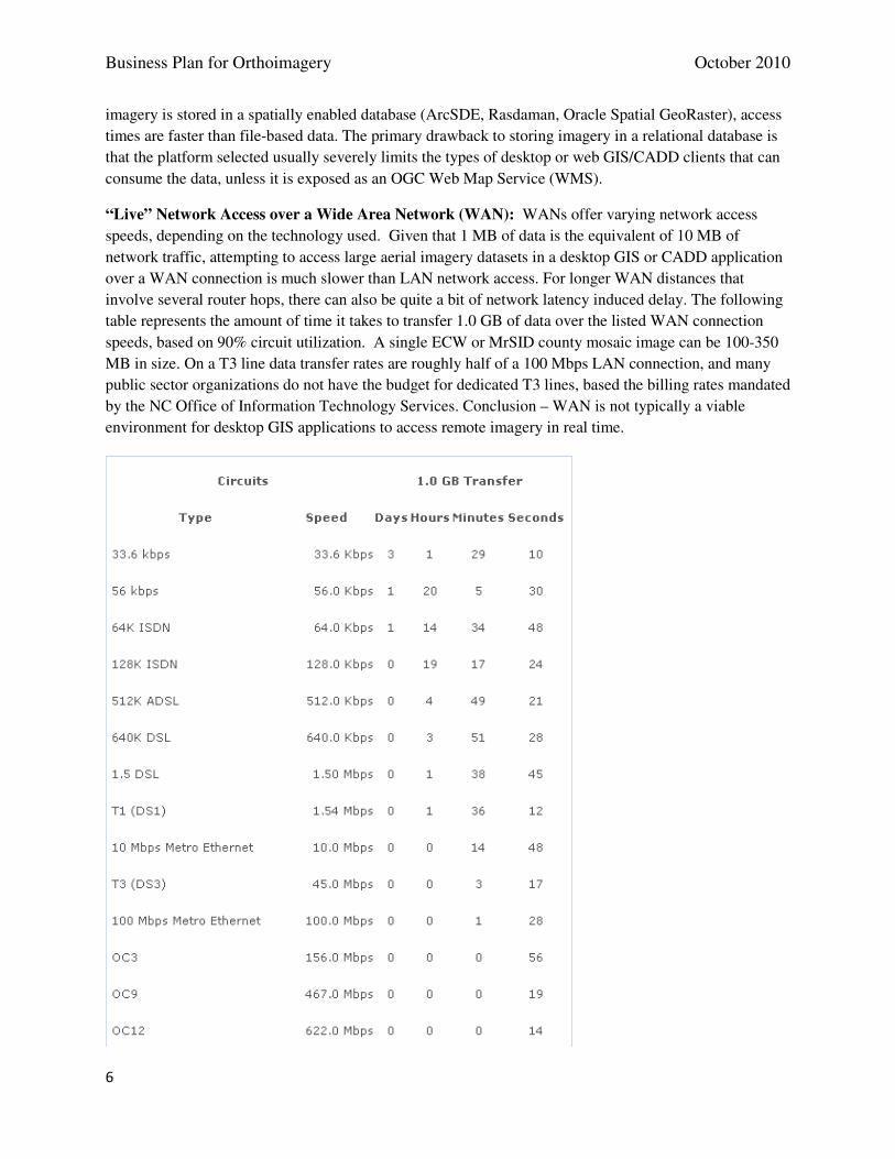
Business Plan for Orthoimagery October 2010
6
imagery is stored in a spatially enabled database (ArcSDE, Rasdaman, Oracle Spatial GeoRaster), access
times are faster than file-based data. The primary drawback to storing imagery in a relational database is
that the platform selected usually severely limits the types of desktop or web GIS/CADD clients that can
consume the data, unless it is exposed as an OGC Web Map Service (WMS).
“Live” Network Access over a Wide Area Network (WAN): WANs offer varying network access
speeds, depending on the technology used. Given that 1 MB of data is the equivalent of 10 MB of
network traffic, attempting to access large aerial imagery datasets in a desktop GIS or CADD application
over a WAN connection is much slower than LAN network access. For longer WAN distances that
involve several router hops, there can also be quite a bit of network latency induced delay. The following
table represents the amount of time it takes to transfer 1.0 GB of data over the listed WAN connection
speeds, based on 90% circuit utilization. A single ECW or MrSID county mosaic image can be 100-350
MB in size. On a T3 line data transfer rates are roughly half of a 100 Mbps LAN connection, and many
public sector organizations do not have the budget for dedicated T3 lines, based the billing rates mandated
by the NC Office of Information Technology Services. Conclusion – WAN is not typically a viable
environment for desktop GIS applications to access remote imagery in real time.
Business Plan for Orthoimagery October 2010
7
Internet downloads using FTP / HTTP / WGET: These data access protocols have been in use for
since the mid 1990s, and are well-tested and are preferred methods to access data from a remote location
and save a copy locally for later use. These protocols are not suitable for “live” access to large, remote
imagery datasets in desktop GIS/CADD applications.
BitTorrent: is a distributed peer-to-peer file sharing protocol. It allows many people to download an
image file without overstraining the hosting server. BitTorrent breaks up files into small pieces and
distribute those pieces on to the PCs of end users who have downloaded the BitTorrent type client. When
a user requests the file to be delivered or streamed to them, rather than having to get it from a host server,
a tracker program determines where all the file pieces are, and defines how the user reassembles them into
a copy of the original on their computer as a file or a stream. This is a good distribution system for those
who create and publish content, but not as good for end-users. BitTorrent expects the end-user to
contribute bandwidth, hard drive storage and processing power, as well as allow anonymous access to
their computer by anyone with a BitTorrent client application who wants a copy of the data. This is why
network security administrators typically forbid the use of BitTorrent in almost all public sector
organizations. With BitTorrent, not only is the user who is searching for imagery completely dependent
on a collection of unknown peers who may or may not be online, have decent bandwidth, or have their
sharing bandwidth set to an reasonable bit-rate. Even if many peers are sharing the specific file that a user
wants a copy of, the data often trickles in at rate that would make a dial-up modem appear fast.
For a time, Earth Resource Mapping, Inc. (ER Mapper) operated the geotorrent.org website and offered
public domain aerial and satellite imagery via BitTorrent, but the site never gained widespread adoption.
When the company was purchased by ERDAS, the geotorrent.org website was taken offline. BitTorrent
is an uncommon method of distributing large imagery datasets. NASA uses it with imagery available on
their Visible Earth website, but they may be the only ones. BitTorrent is not a suitable method for aerial
imagery distribution by or to North Carolina government agencies.
OGC “Web Map Service” (WMS): WMS is a vendor-neutral interoperability standard that allows both
desktop and web-based applications to request ad-hoc map images, rendered on the fly, from any map
server that supports the standard. The map server renders a picture of the imagery for the specified area,
often overlaid with vector data layers, and sends the small picture to the requesting application rather than
the actual imagery itself. Image sizes are typically small – 100-300 kb, depending on the complexity of
the map images and the image quality the server is programmed to deliver. File delivery format is
typically JPEG for non-transparent images and GIF or PNG for images with transparency. Some WMS
server can deliver output from an aerial imagery map service in other non-image formats, such as SVG,
PDF, SWF, or EPS.
This is a very viable method of access to aerial imagery in viewing applications without needing to have a
copy of the imagery locally. WMS does have three primary drawbacks:
• WMS can be slow if the server is not sufficiently resourced/sized or the network bandwidth is inadequate.
Business Plan for Orthoimagery October 2010
8
• WMS map services typically place a cap on the size of an image it will generate, meaning end-users with very large computer monitors may not be able to maximize their application windows without exceeding the image size a WMS server is willing to render.
• It is rarely possible to print large format maps (D or E sized) from an aerial imagery WMS service. The typical screen resolution of WMS output is 96 dpi and is meant for viewing rather than printing. The image rendered by the server may be 800 x 600 pixels in size. For printing a high quality map, the resolution may need to be 300 - 600 dpi. An E sized plot is 34 x 44 inches, so the image the WMS server needs to generate for a 300 dpi plot would be (34*300) x (44* 300), or 10,200 x 13,200 pixels in size – much larger than most WMS map servers can accommodate.
OGC “Web Map Tile Service” (WMTS): “Mass Market” mapping service providers such as Google,
Yahoo, Microsoft and OpenStreetMap all achieve their very fast response speeds by using pre-rendered
and cached map images, at specific map scales or zoom levels. Each of these services was implemented
with different formats, tiling schemes and access mechanisms. GIS web-mapping products such as
ArcGIS Server, TileCache and GeoWebCache subsequently gained the ability to generate cached image
tile pyramids, each with its own format. To resolve the interoperability problem, the OGC worked with
the OSGEO and the rest of the geospatial industry to develop the WMTS standard, largely based on the
OSGEO TMS format, for the purpose of enabling map tiles from many different providers to be accessed
in the same manner.
The WMTS service is an image tile hierarchy, (sometimes referred to as a pyramid), covering multiple
map scales. It automatically returns map tiles from the most appropriate pyramid / zoom level for any
given map scale and area. WMTS is not a replacement for WMS, because pre-rendered, cached map
images offer far less flexibility than what can be achieved by an OGC WMS server. However, using pre-
rendered and cached map images tiles is a very fast and efficient way of delivering maps to web
applications. Version 1.0 of the official WMTS specification was released in April 2010. As it is a very
new standard, it is not yet supported by many desktop GIS applications. Some map tile server products
such as Cubewerx’s Cubeserv, GeoWebCache and TileCache very quickly implemented the new WMTS
specification. Other popular web mapping software, such as ArcGIS Server and Erdas Apollo do not yet
support WMTS, but plan to in future releases. The main drawbacks to WMTS are the same as for any
pre-rendered image map tile cache system:
• Requires much larger disk space resources
• The imagery is available only at pre-set map scales
• Extra time and server resources are needed to generate the image caches
• If new source imagery becomes available, all levels of the cache must be regenerated in order to use it.
• Each image cache is available only in a single coordinate reference system.
If speed of delivery is the primary requirement, WMTS is a very viable way of serving large amounts of
aerial imagery data to web mapping applications, but is not yet a viable option for delivery of aerial
photography to most desktop GIS packages.
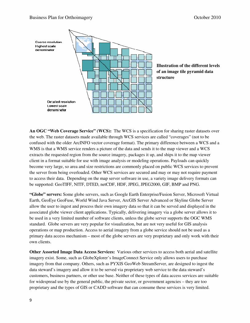
Business Plan for Orthoimagery October 2010
9
Illustration of the different levels
of an image tile pyramid data
structure
An OGC “Web Coverage Service” (WCS): The WCS is a specification for sharing raster datasets over
the web. The raster datasets made available through WCS services are called “coverages” (not to be
confused with the older ArcINFO vector coverage format). The primary difference between a WCS and a
WMS is that a WMS service renders a picture of the data and sends it to the map viewer and a WCS
extracts the requested region from the source imagery, packages it up, and ships it to the map viewer
client in a format suitable for use with image analysis or modeling operations. Payloads can quickly
become very large, so area and size restrictions are commonly placed on public WCS services to prevent
the server from being overloaded. Other WCS services are secured and may or may not require payment
to access their data. Depending on the map server software in use, a variety image delivery formats can
be supported: GeoTIFF, NITF, DTED, netCDF, HDF, JPEG, JPEG2000, GIF, BMP and PNG.
“Globe” servers: Some globe servers, such as Google Earth Enterprise/Fusion Server, Microsoft Virtual
Earth, GeoEye GeoFuse, World Wind Java Server, ArcGIS Server Advanced or Skyline Globe Server
allow the user to ingest and process their own imagery data so that it can be served and displayed in the
associated globe viewer client applications. Typically, delivering imagery via a globe server allows it to
be used in a very limited number of software clients, unless the globe server supports the OGC WMS
standard. Globe servers are very popular for visualization, but are not very useful for GIS analysis
operations or map production. Access to aerial imagery from a globe service should not be used as a
primary data access mechanism – most of the globe servers are very proprietary and only work with their
own clients.
Other Assorted Image Data Access Services: Various other services to access both aerial and satellite
imagery exist. Some, such as GlobeXplorer’s ImageConnect Service only allows users to purchase
imagery from that company. Others, such as PYXIS GeoWeb StreamServer, are designed to ingest the
data steward’s imagery and allow it to be served via proprietary web service to the data steward’s
customers, business partners, or other use base. Neither of these types of data access services are suitable
for widespread use by the general public, the private sector, or government agencies – they are too
proprietary and the types of GIS or CADD software that can consume these services is very limited.
Business Plan for Orthoimagery October 2010
10
Data Delivery and Access Recommendations
A copy of an imagery dataset should be maintained in uncompressed GeoTIFF format as the “master” or
“archival” version. This version of the imagery should be delivered using a variety of methods, for
different user groups:
• If disk space on the map server is adequate, to power a WMS map service that outputs ad-hoc rendered images for general map viewer or desktop GIS use. Either as a file-based image catalog, or as a layer in a spatially enabled database.
• Via portable hard drive or WCS services for access by remote sensing and image analysts who need the full resolution imagery to perform their analysis and modeling operations. Small study areas may be obtained from a WCS, but large areas will need to be transferred in an offline manner.
• Optional - If disk space on the map server is adequate, the imagery should be pre-rendered into map tiles and served as a WMTS service for use in web mapping clients.
• Optional - If the software is available, the imagery may be ingested into a Globe server to power visualization services in the associated Globe viewer client.
A copy of an imagery dataset should be converted to a highly compressed format such as ECW or MrSID
for general use as map backgrounds. This version of the imagery should also be delivered using a variety
of methods, for different user groups:
• Over a Local Area Network (LAN) as an image catalog or in a spatially enable relational database layer for use by desktop clients in the same facility as the fileserver. This is needed to print large, high quality maps.
• Zipped, and made available for Internet downloads using FTP / HTTP / WGET.
• Optional – packaged for use on mobile devices
• Optional, and only marginally viable – served over a Wide Area Network (WAN) as an image catalog or in a spatially enable relational database layer for use by desktop clients in nearby facilities, provided the WAN speed is T3 or better.
An alternative for delivering the statewide WMS and WMTS map services to the many potential users is
to utilize hosted “Infrastructure-As-A-Service” (IaaS) offerings from a commercial cloud computing
provider. The use of a hosted IaaS environment can mitigate the slow map service delivery speeds and
bandwidth issues associated with hosting services on the State network. Additional desirable features of
using a hosted cloud computing platform include the ability of map servers to utilize automatic scaling
and load balancing features. Some hosting providers also offer distributed “edge network” content
delivery solutions, which can provide dramatic performance increases in serving the pre-rendered map
tiles used in WMTS services.
If relying solely upon a commercially hosted platform is not considered a viable alternative for political
reasons, a hybrid solution, commonly known as “cloudbursting” may also be used. In this model, the
main WMS and WMTS map services would be hosted on the State of NC network, but when demand for
services increases beyond the State’s capacity to provide an acceptable level of service, supplemental
virtual servers in a commercial cloud computing environment could be provisioned on-demand to address
the spike in web service request traffic. Cloudbursting is typically used to handle seasonal or event-based
Business Plan for Orthoimagery October 2010
11
traffic peaks. As the aerial imagery produced by State and Federal Agencies is in the public domain, it is
an ideal candidate for exploring the benefits of hosted cloud infrastructure because there are no security
restrictions on the data and it does not change.
Monthly charges for hosting applications and large volumes of data on a commercially provided cloud
platform will depend upon a variety of factors (size of data files transferred to the cloud by application
owner, number and size of virtual server instances deployed, size of data transferred out of the cloud to
service user requests, number and duration of on-demand auto-scaled servers used, storage required for
persistent data files and backup snapshots, support contracts, etc.). The costs associated with each service
provider cannot easily be estimated unless disk storage requirements, number of virtual servers, and a
baseline for monthly usage traffic is already known. Hosting providers also offer Service Level
Agreements that vary widely in their suitability for Government applications. Some even require that the
customer document and provide proof of downtime in order to obtain “service credits”, yet they provide
no tools for analyzing application server instance or storage volume downtimes
The European Network and Information Security Agency (ENISA) conducted a risk assessment on cloud
computing business model and technologies. The result is an in-depth and independent analysis that
outlines some of the information security benefits and key security risks of cloud computing. The report
provides a set of practical recommendations.
http://www.enisa.europa.eu/act/rm/files/deliverables/cloud-computing-risk-
assessment/at_download/fullReport
The following case study illustrates how the Swiss government has successfully used Amazon EC2 and
S3 storage services to provide web mapping and imagery services to 30,000 unique visitors per day, with
a map delivery speed of up to 1,300 map tiles per second.
http://aws.amazon.com/solutions/case-studies/swisstopo/