Embed Size (px)
Citation preview
Burnewood Neighbourhood Area Structure P lan
Office Consolidation July 2015
Prepared by:
Planning and Policy Services Branch Planning and Development Department
City of Edmonton Bylaw 6055 was adopted by Council in June 1980. In October 2012, this document was consolidated by virtue of the incorporation of the following bylaws: Bylaw 6055 Approved June 25, 1980 (to adopt the Burnewood Neighbourhood Area Structure Plan) Bylaw 9423 Approved April 10, 1990 (to redesignate the lands in the northeast portion of the plan to
RF1 (Single Detached Residential) and RPL (Planned Lot Residential)) Bylaw 9768 Approved May 14, 1991 (to modify residential uses, institutional uses, school/park site,
and roadways in the plan area; and, to revise the entire text of the plan) Bylaw 9945 Approved March 10, 1992 (to convert the King’s College land to residential development) Bylaw 10180 Approved August 17, 1992 (to redesignate a 0.265 parcel in the eastern portion of the plan
area from commercial to low rise residential) Bylaw 11539 Approved July 15, 1997 (to modify the design of the top-of-bank roadway from
continuous to intermittent) Bylaw 13263 Approved February 13, 2003 (to accommodate an expansion to the on-site parking area for
the religious assembly in the northwest portion of the plan area) Bylaw 16019 Approved October 17, 2012 (to accommodate Medium Density Residential uses for
seniors housing on surplus school building envelope located on a school/park site) Bylaw 17261 Approved July 6, 2015 (to redesignate an area identified for townhouse development for
apartment development on Jamha Road in the Burnewood neighbourhood) Editor’s Note: This is an office consolidation edition of the Burnewood Neighbourhood Area Structure Plan, Bylaw 6055, as approved by City Council on June 25, 1986. This edition contains all amendments and additions to Bylaw 6055. For the sake of clarity, new maps and a standardized format were utilized in this Plan. All names of City departments have been standardized to reflect their present titles. Private owners’ names have been removed in accordance with the Freedom of Information and Protection of Privacy Act. Furthermore, all reasonable attempts were made to accurately reflect the original Bylaws. All text changes are noted in the right margin and are italicized where applicable. This office consolidation is intended for convenience only. In case of uncertainty, the reader is advised to consult the original Bylaws, available at the office of the City Clerk. City of Edmonton Planning and Development Department
Burnewood NASP Office Consolidation July 2015
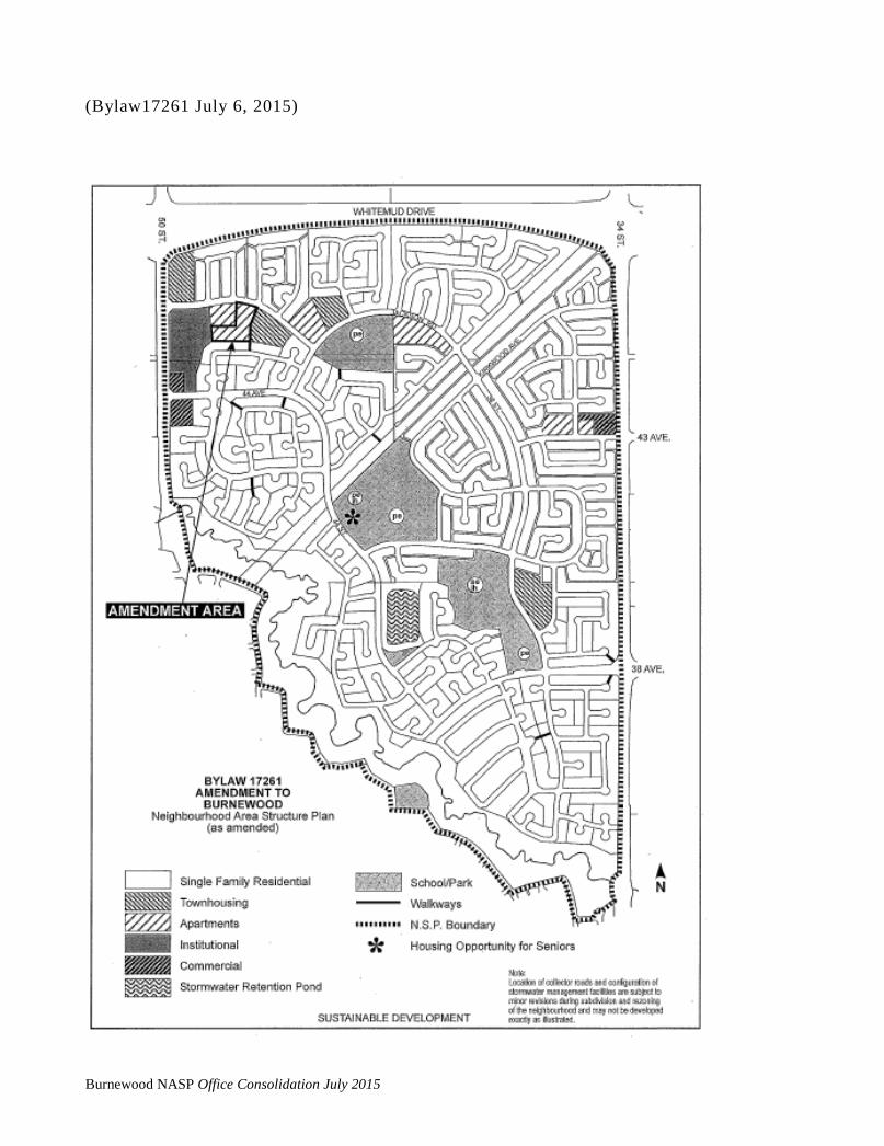
(Bylaw17261 July 6, 2015)
Burnewood NASP Office Consolidation July 2015

BURNEWOOD NEIGHBOURHOOD AREA STRUCTURE PLAN
Burnewood NASP Office Consolidation July 2015

TABLE OF CONTENTS (Amended by Editor)
1.0 INTRODUCTION AND BACKGROUND ......................................................................... 1 1.1 Introduction ........................................................................................................................... 1 1.2 Existing Burnewood Neighbourhood Area Structure Plan ................................................... 1 1.3 Land Ownership .................................................................................................................... 2 1.4 Development Rationale......................................................................................................... 2 1.5 Reasons for Amending the Burnewood Neighbourhood Area Structure Plan ...................... 2 2.0 THE AMENDED BURNEWOOD NEIGHBOURHOOD STRUCTURE PLAN ............... 11 2.1 Land Use Details ................................................................................................................... 11 2.2 Proposed Land Use Zones..................................................................................................... 12 2.3 Population Projections .......................................................................................................... 12 2.4 Student Generation Statistics ................................................................................................ 12 2.5 A Comparison of the 1990 Burnewood Plan and this Burnewood Plan .............................. 13 Amendment 3.0 DEVELOPMENT STRATEGY FOR BURNEWOOD ...................................................... 22 3.1 Development Objectives ...................................................................................................... 22 3.2 Development Concept........................................................................................................... 22 4.0 ENGINEERING SERVICES AND UTILITIES ................................................................. 25 4.1 General .................................................................................................................................. 25 4.2 Storm Drainage ..................................................................................................................... 25 4.3 Sanitary Sewerage ................................................................................................................ 25 4.4 Water Supply ........................................................................................................................ 26 4.5 Gas, Power and Telephone ................................................................................................... 27 5.0 TRANSPORTATION SYSTEM ......................................................................................... 32 5.1 Road Network ....................................................................................................................... 32 5.2 Transit Service ..................................................................................................................... 33 5.3 Walkways ............................................................................................................................. 33 6.0 SITE FEATURES ................................................................................................................. 34 6.1 Mill Creek Ravine and Soil Stability .................................................................................... 34 6.2 Pipeline Corridor .................................................................................................................. 34 6.3 Vegetation ............................................................................................................................ 34 6.4 Topography ........................................................................................................................... 34
Burnewood NASP Office Consolidation July 2015

LIST OF ILLUSTRATIONS Map 1 Vicinity ....................................................................................................................... 5 Map 2 Location ...................................................................................................................... 6 Map 3 1990 NASP Development Concept ............................................................................. 7 Map 4 Neighbourhood Boundaries ........................................................................................ 8 Map 5 Current Land Use Districts ......................................................................................... 9 Map 6 Land Ownership .......................................................................................................... 10 Map 7 Proposed Burnewood Land Use Plan .......................................................................... 20 Map 8 Proposed Land Use Zones ........................................................................................... 21 Map 9 Storm Drainage ........................................................................................................... 28 Map 10 Sanitary Sewerage ....................................................................................................... 29 Map 11 Water Supply .............................................................................................................. 30 Map 12 Gas, Power and Telephone.......................................................................................... 31 Map 13 Topographical Survey, Contour Plan and Wooded Areas .......................................... 35 LIST OF FIGURES Figure 1 Land Use Statistics ...................................................................................................... 14 Figure 2 School and Municipal Reserve Requirements ............................................................ 15 LIST OF TABLES Table 1 Potential Residential Dwelling Unit Mix .................................................................... 16 Table 2 Population Projection .................................................................................................. 17 Table 3 Student Generation ...................................................................................................... 18 Table 4 Potential Residential Dwelling Unit Mix and Population .......................................... 19 Comparison
Burnewood NASP Office Consolidation July 2015

The school/park site is amended to include the opportunity for medium density housing for seniors on the surplus school building envelope. The precise location of this housing within the entire School/Park site will be determined by the City. The dwelling units and population generated by this development are not included in the land use and population statistics.
1.0 INTRODUCTION AND BACKGROUND
1.1 Introduction
This report represents a comprehensive amendment to the Neighbourhood Area Structure Plan (NASP) for Burnewood (Mill Woods), which was originally adopted by City Council on June 25, 1980, as Bylaw 6055. This Bylaw was subsequently amended by Bylaw No 9423 on March 8, 1990. That amendment deleted some multiple family sites in the extreme northeast portion of Burnewood and replaced them with a single family designation. The proposed NASP amendment replaces all previous amendments to the Burnewood NASP. It has been prepared by the Land Management and Systems Branch of the Planning and Development Department∗ on behalf of the City of Edmonton and property owners in the plan area. The objective of the plan amendment is to facilitate the development of an attractive residential environment for some of the last large tracts of developable land in Mill Woods.
1.2 Existing Burnewood Neighbourhood Area Structure Plan
The Burnewood neighbourhood is comprised of approximately 756 acres and is located in the northeast sector of Mill Woods (refer to Map 1). It is bounded by Whitemud Drive on the north, 34th Street on the east, Mill Creek Ravine to the south, and 50th Street on the west (refer to Map 2).
The existing development concept for Burnewood (1990) provides for a range of low to medium density housing types (i.e., single detached housing, townhouses, and apartments) (refer to Map 3). The neighbourhood focus is primarily on the various educational and recreational facilities, including the Mill Creek Ravine, which forms the eastern boundary of the plan area. Multi-family sites (apartments and townhouses) have been located along collector roads and at neighbourhood entrance points, providing a transition to the single family residential areas which make up the majority of residential lands. Other land uses identified for Burnewood are two (2) commercial centres, a church, two (2) stormwater lakes, and a district park, and a possible district athletic park and high school.
∗ The Land Management and Systems Branch is now part of the Asset Management and Public Works Department
Amended by Editor
Bylaw 16019 October 17, 2012
Burnewood NASP Office Consolidation July 2015 1

Three neighbourhoods were identified in the Burnewood Neighbourhood Area Structure Plan (1990): Jackson Heights, Kiniski Gardens, and Flynn Dell. More recently, the Executive Committee approved the deletion of the name "Flynn Dell" in favour of Jackson Heights (northwest of the pipeline right of way) and Kiniski Gardens (south and east of the pipeline right of way). To date, development has taken place in Kiniski Gardens, and most recently, in Jackson Heights (refer to Map 4). As of May 1990, Burnewood had a population of 3,269. The total number of residences was 1,093 of which approximately 90% were single family residences. Other developments include Julia Kiniski Elementary School and a neighbourhood convenience commercial centre.
Current land use zones for Burnewood are shown on Map 5. A significant portion of the single-family lands, both developed and undeveloped, are zoned for Planned Lot Residential (RPL) development. RPL zoning is typically used to accommodate single detached housing on small lots. This type of single family residential development is concentrated in the older, developed portion of Kiniski Gardens.
1.3 Land Ownership
Map 6 identifies land ownership for the undeveloped lands in Burnewood. The City of Edmonton originally owned 159 acres of developable land. Most of this land is located in the Jackson Heights neighbourhood. Other large landowners are: 5 private corporations, The King's College, and a private institution (religious assembly).
1.4 Development Rationale
The City of Edmonton would like to complete the sale and development of its land holdings in Jackson Heights and Kiniski Gardens, as the lands are ideally suited for residential development and immediately serviceable. The Land Management Branch of the Planning and Development Department has taken a coordinating role on behalf of all landowners in forwarding this NASP Amendment because of the necessity of preparing a comprehensive document to replace the existing NASP. It is recognized that individual landowners have different design and staging constraints and will promote the design options and timing best suited to their corporate objectives and perceived market opportunities.
Section 1.5 Bylaw 9945
March 10, 1992 Amended by Editor
Deleted Section 1.5
Bylaw 17261 July 6, 2015
Amended by Editor
Amended by Editor
Burnewood NASP Office Consolidation July 2015 2
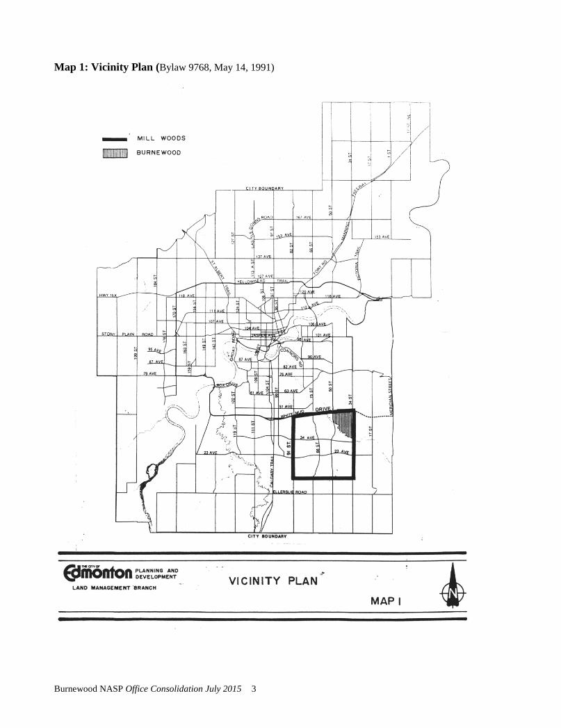
Map 1: Vicinity Plan (Bylaw 9768, May 14, 1991)
Burnewood NASP Office Consolidation July 2015 3

Map 2: Location Plan (Bylaw 9768, May 14, 1991)
Burnewood NASP Office Consolidation July 2015 4

Editor’s Note – This map establishes the historical context of the Burnewood Neighbourhood Area Structure Plan (1990). Refer to page 20 for the current Development Concept Map.
Map 3: 1990 NSP Development Concept (Bylaw 9768, May 14, 1991)
Burnewood NASP Office Consolidation July 2015 5
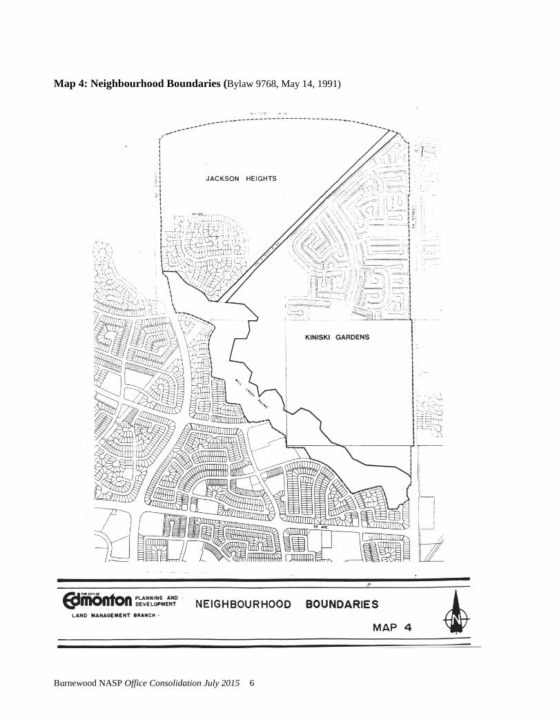
Map 4: Neighbourhood Boundaries (Bylaw 9768, May 14, 1991)
Burnewood NASP Office Consolidation July 2015 6
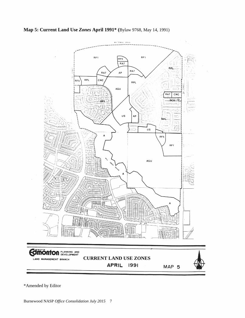
Map 5: Current Land Use Zones April 1991* (Bylaw 9768, May 14, 1991)
*Amended by Editor
CURRENT LAND USE ZONES
Burnewood NASP Office Consolidation July 2015 7

Map 6: Land Ownership* (Bylaw 9768, May 14, 1991)
Burnewood NASP Office Consolidation July 2015 8
2.0 THE AMENDED BURNEWOOD NEIGHBOURHOOD STRUCTURE PLAN
2.1 Land Use Details
Land use information for the amended Burnewood Neighbourhood Area Structure Plan is outlined in Figures 1 and 2 and Map 7. The Burnewood community comprises 755.21 acres of land. The majority of this land is devoted to residential development.
As illustrated in Table 1, the revised Burnewood NASP has a well balanced mix of various residential housing forms, including single family, townhousing, and apartments. A site for social housing is provided on City-owned land in Jackson Heights Stage III, in the northwestern portion of the plan area. This mix conforms with the City's objective of developing a broad range of living environments to support the provision of community services (e.g., recreational and educational facilities) as well as creating heterogeneous communities.
Single family detached housing is the predominant land use with some land identified for town housing and apartments. Most of these medium density uses are adjacent to either collector roads or educational/recreational sites.
As proposed, there will be varying forms/densities of single family housing in Burnewood. The majority of the single family houses already developed in Kiniski Gardens are on small lots. Areas developed for single detached housing in the NASP Amendment area are intended to accommodate housing of a traditional RF1 nature. Should market demands for small lot housing emerge, then such small lot housing should be accommodated through the judicious use of the RPL zone. Within the RPL zone, every effort should be made to maintain an RF1 character.
Other land uses identified for Burnewood include: three school/park sites that will accommodate two public elementary schools in addition to the existing Julia Kiniski School, a separate elementary school, a public junior high school on the Julia Kiniski site, a stormwater lake/park and four commercial centres. The four commercial centres will consist of a 0.69 hectare (1.72 acre) site on 43 Avenue and 34 Street (which is partially developed), a 0.8 hectare (2.00 acre) development at the west entrance to Burnewood on 50 Street and 44 Avenue, a 0.13 hectare (0.32 acre) commercial project at the southeast
Amended by Editor
Bylaw 10180 August 17, 1992
Bylaw 13263 February 13, 2003
Amended by Editor
Bylaw 13263 February 13, 2003
Amended by Editor Bylaw 17261 July 6, 2015
Burnewood NASP Office Consolidation July 2015 9

corner of 43 Avenue and 34 Street, and a 0.37 ha site on the northwest corner of 50 Street and 44 Avenue. These commercial centres will mainly cater to local community needs.
A public school site of 5.5 acres is shown in the southeast portion of the plan, adjoining the proposed separate school site. A PUL lot separating the two school sites is proposed to be registered at the subdivision stage in order to accommodate municipal services.
2.2 Proposed Land Use Zones
To implement this amended Burnewood Neighbourhood Area Structure Plan, a number of land use bylaw amendments are required. Map 8 shows the proposed land use zones for Burnewood. This will be achieved by a number of separate Zoning Bylaw Amendments as development progresses.
In order to achieve a high quality of neighbourhood design and an appropriate transition between different land uses or housing forms, it is intended that commercial or higher density residential uses will be developed under the provisions of site specific zoning. Alternatively, the Planning and Development Department will give consideration to implementing developments through standard zoning based on appropriate subdivision design or revised development controls as reflected in amendments to the standard districts of the Zoning Bylaw.
2.3 Population Projections
It is projected that Burnewood will ultimately be populated by approximately 12,744 people (refer to Table 2), living in 3,931 various types of housing units (single family homes, townhouses, and apartments).
The proposed population capacity is comparable to other Mill Woods' communities such as Woodvale (9,044 population capacity), Lakewood (11,666), Knottwood (11,780) and Millhurst (11,195). This population base is sufficient to support a wide range of community services.
2.4 Student Generation
Student generation information for Burnewood is shown in Table 3. These figures are derived by using dwelling unit information and standard student generation factors.
Amended by Editor
Amended by Editor
Bylaw 13263 February 13, 2003
Burnewood NASP Office Consolidation July 2015 10
Once Burnewood is fully developed, it is forecast that there will be 1,371 public elementary students, 587 separate elementary students, 608 public junior students, 273 separate junior students, 497 public senior students, and 158 separate senior students. Elementary and junior high school sites have been identified for Burnewood. Please refer to Map 7 for school site locations.
Section 2.5, Bylaw 13263, February 13, 2003
Section 2.5 deleted, Bylaw 17261, July 6, 2015
Burnewood NASP Office Consolidation July 2015 11
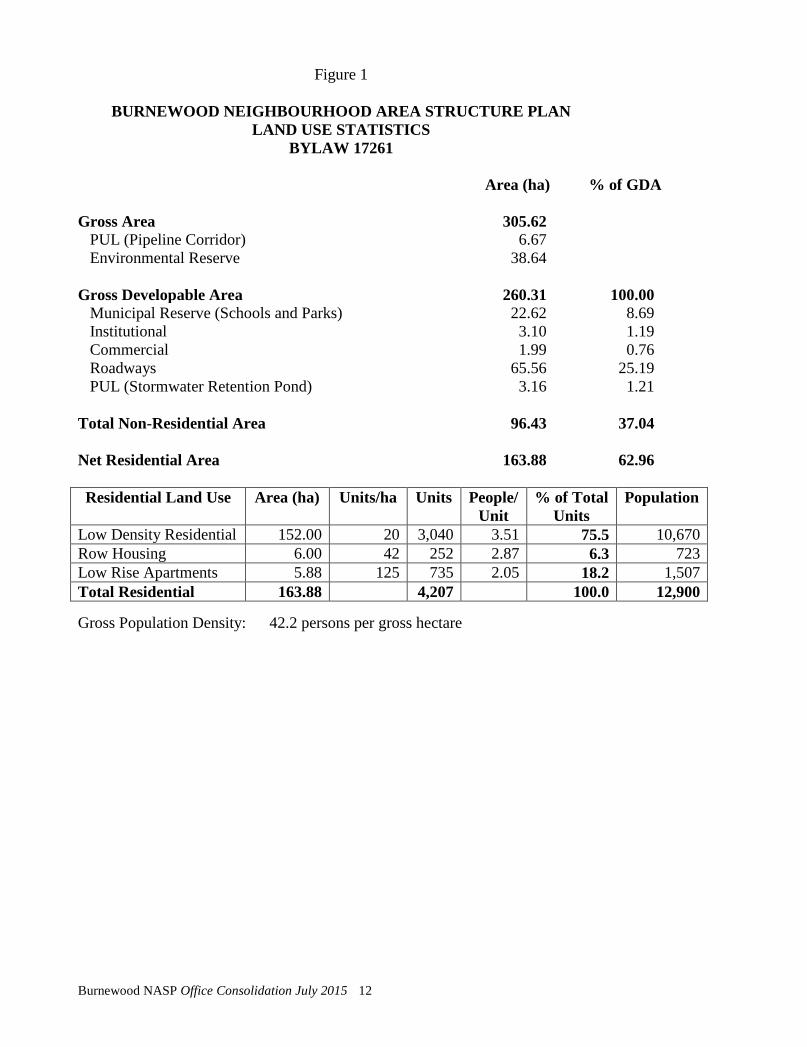
Figure 1
BURNEWOOD NEIGHBOURHOOD AREA STRUCTURE PLAN LAND USE STATISTICS
BYLAW 17261
Area (ha) % of GDA Gross Area 305.62 PUL (Pipeline Corridor) 6.67 Environmental Reserve 38.64 Gross Developable Area 260.31 100.00 Municipal Reserve (Schools and Parks) 22.62 8.69 Institutional 3.10 1.19 Commercial 1.99 0.76 Roadways 65.56 25.19 PUL (Stormwater Retention Pond) 3.16 1.21 Total Non-Residential Area 96.43 37.04 Net Residential Area 163.88 62.96 Residential Land Use Area (ha) Units/ha Units People/
Unit % of Total
Units Population
Low Density Residential 152.00 20 3,040 3.51 75.5 10,670 Row Housing 6.00 42 252 2.87 6.3 723 Low Rise Apartments 5.88 125 735 2.05 18.2 1,507 Total Residential 163.88 4,207 100.0 12,900 Gross Population Density: 42.2 persons per gross hectare
Burnewood NASP Office Consolidation July 2015 12
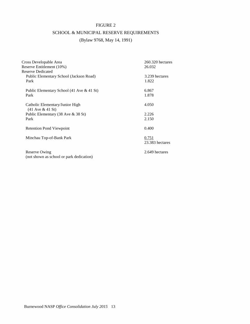
FIGURE 2 SCHOOL & MUNICIPAL RESERVE REQUIREMENTS
(Bylaw 9768, May 14, 1991)
Cross Developable Area Reserve Entitlement (10%) Reserve Dedicated
260.320 hectares 26.032
Public Elementary School (Jackson Road) Park
3.239 hectares 1.822
Public Elementary School (41 Ave & 41 St) 6.867 Park
1.878
Catholic Elementary/Junior High 4.050 (41 Ave & 41 St)
Public Elementary (38 Ave & 38 St) 2.226 Park
2.150
Retention Pond Viewpoint
0.400
Minchau Top-of-Bank Park 0.751 23.383 hectares
Reserve Owing (not shown as school or park dedication)
2.649 hectares
Burnewood NASP Office Consolidation July 2015 13

TABLE 3 STUDENT GENERATION
(Bylaw 9945, March 10, 1992)
Public
Elementary Separate Elementary
Public Junior
Separate Junior
Public Senior
Separate Senior
Dwelling Units (Residential Use)
1,620 (RF1) 697 292 324 146 259 81 1,325 (RPL) 569 239 265 119 212 66 321 (RF5) 138 58 39 16 39 10 558 (RA7) 61 39 22 11 22 11 TOTAL 1,465 628 650 292 532 168
Burnewood NASP Office Consolidation July 2015 14
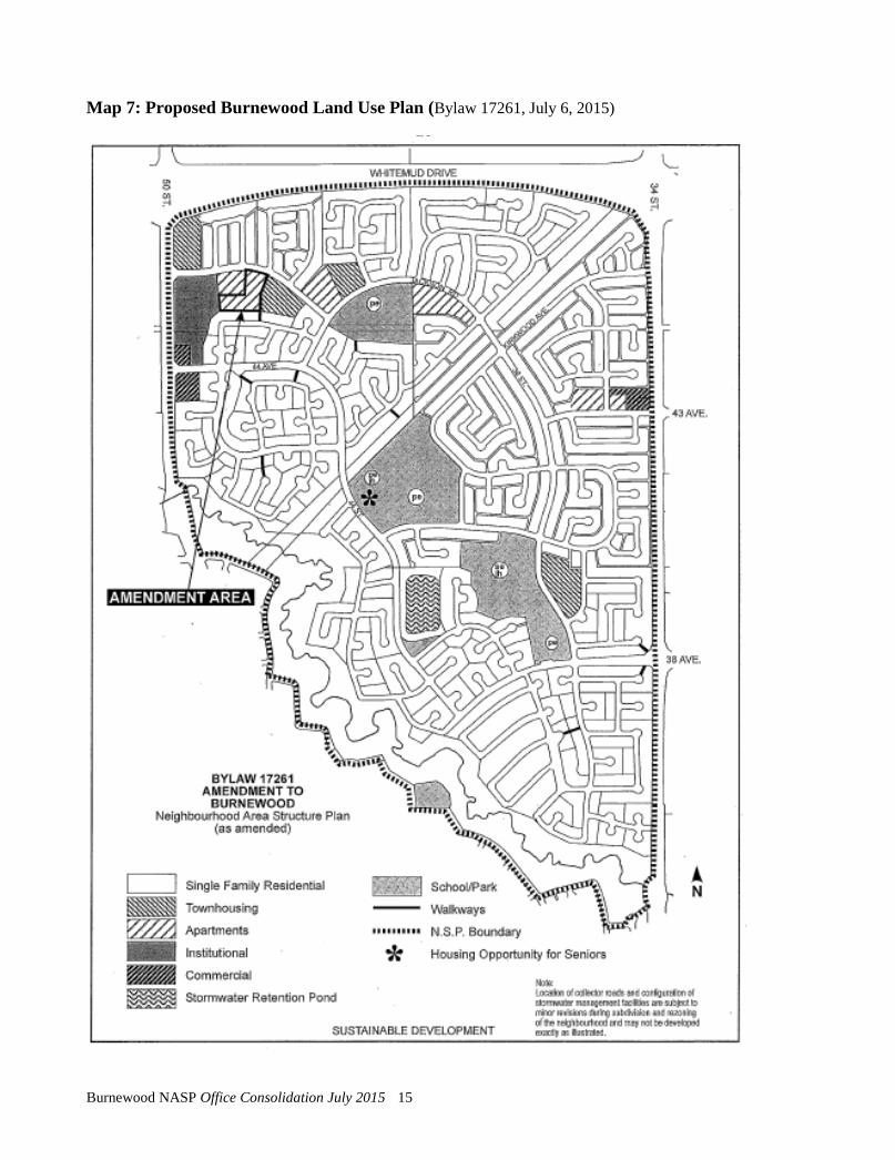
Map 7: Proposed Burnewood Land Use Plan (Bylaw 17261, July 6, 2015)
Burnewood NASP Office Consolidation July 2015 15

Map 8: Proposed Land Use Zones* (Bylaw 9768, May 14, 1991)
*Amended by Editor
PROPOSED LAND USE ZONES
Burnewood NASP Office Consolidation July 2015 16
3.0 DEVELOPMENT STRATEGY FOR BURNEWOOD
3.1 Development Objectives
The various landowners in the plan area intend to develop this land in accordance with the following development objectives:
To develop a community which is reasonably self-sufficient in terms of community services.
To create a community that takes advantage of the natural beauty and accessibility of the Mill Creek Ravine.
To integrate the entire community while allowing for different living environments.
To provide residential development sites that meet consumer demands.
To create an attractive and pleasing residential community.
To integrate the various land uses to ensure compatibility.
To provide for the safe and convenient movement of pedestrians and vehicles.
To develop an engineering servicing system that is cost efficient and meets current and future demands.
To market the land in an timely manner, thus ensuring early threshold levels for the provision of community services.
To encourage attractive and high quality built forms for all types of development.
3.2 Development Concept.
The majority of the land in Burnewood is designated for residential purposes. This Plan Amendment provides for the development of predominantly single detached housing. This is in response to current and anticipated consumer preference, as well as the fact that very little multiple family housing has been recently built. The single family areas will be zoned RF1 (Single Detached Residential Zone).
Amended by Editor
Burnewood NASP Office Consolidation July 2015 17
The various landowners in the plan area intend to develop their single family residential area with varying lot sizes and densities. Single family lots closest to the Mill Creek Ravine will be developed within a range of widths of 55 to 70 feet. These lots will cater to the move-up market in Southeast Edmonton. Lot sizes will decrease with distance from the Mill Creek Ravine.
A range of residential uses are also planned in the area bordered by Whitemud Avenue to the north, Jamha Road to the south, to the west 50 Street, and to the east by land zoned RF1 and land designated multiple family. The land uses proposed contemplate the development of three types of residential development. Those types are RF1 (Single Detached Residential), RPL (Planned Lot Residential) and RF5 (Row Housing Zone).
The Single Detached Residential area will contain approximately 50 lots. The single detached housing has been proposed adjacent to the Whitemud Drive and along the east side of the area. The reason being to minimize the number of dwelling units along the Whitemud Drive and to be compatible with the lands that are currently zoned RF1. To minimize adverse affects associated with the Whitemud Drive, a berm will be developed at the rear of the lots abutting the roadway. A small portion of the single detached lots on the east side abut a future Low Rise Apartment site (RA7). To address the issue mitigative measures will be implemented at the subdivision approval stage to provide screening between the sites.
The Row Housing site will consist of approximately 35 dwellings. The site will be developed in accordance with architectural guidelines and density restrictions which will be caveated against the title of the land as a restrictive covenant. The guidelines will assure high quality development which is both functional and aesthetically pleasing.
The Planned Lot Residential lands consist of approximately 131 lots. Short functional streets have been proposed so as to reduce the number of homes per block. In addition, lot layout has been such that those lots which abut Jamha Road and the Multiple Family site to the south will flank Jamha Road.
The developer has prepared architectural guidelines which control and ensure the quality of development within the RF1 and RPL areas. The guidelines will be caveated against the titles by restrictive covenant. The imposition of architectural guidelines has been provided over and above the municipal requirements of the Zoning Bylaw.
Bylaw 9945 March 10, 1992
Amended by Editor
Burnewood NASP Office Consolidation July 2015 18
The guidelines prohibit front drive access and parking within the front yard, thereby reducing the automobile oriented streetscape associated with the front drive. To alleviate the potential for excessive parking on the street in the initial phase of the development, the developers will require the builder to provide a graveled parking pad in the rear yard which will accommodate two vehicles. This condition, in addition is to be caveated against the title through the architectural guidelines, will be implemented through the sales agreement, between developer and builder.
The guidelines ensure home facades are attractive in scale and style. The guidelines contain statements that restrict identical floor plans with similar front elevations in close proximity and the repetitive use of similar elevations. Attention has been paid to ensure a smooth transition between different house styles. The guidelines will be approved by the Planning and Development Department prior to approval of any RF1 or RPL subdivision within the area.
A commercial centre has been designated for the southeast and northeast corners of 50th Street and 44th Avenue. By imposing built form guidelines, requiring intensive on-site landscaping, strict building setback requirements, and limiting the type of commercial uses, a commercial development can be designed that will be sympathetic and blend in with the surrounding single family homes. This will be accomplished through direct controls on development.
It is intended that an attractive subdivision will be developed by beautifying street entrances, providing landscaped boulevards/medians, and planting mature trees. These features will be a benefit to all residents of Burnewood.
The developer will provide additional boulevard planting on the north side of Jamha Road, adjacent to the subdivision as well as along the roadways. A minimum of 24 trees and 120 shrubs will be planted along Jamha Road. The trees and shrubs will be planted in the boulevard between the sidewalk and the road curb. The minimum number will be based on one tree per 15 lineal metres of roadway. The trees or shrubs will be planted in the boulevard between the sidewalk and the road curb. The developer will provide landscaping plans to the satisfaction of the Community Services Department at the Engineering Drawing Stage.
Bylaw 9945 March 10, 1992
Bylaw 13263 February 13, 2003
Burnewood NASP Office Consolidation July 2015 19

4.0 UTILITY SERVICING
4.1. General
The proposed amendments to the Neighbourhood Area Structure Plan will not change the servicing concepts proposed in the original Plan, however, certain alignment details have been refined.
4.2 Storm Drainage
The minor storm sewer system in Burnewood will drain to two connected storm water lakes with an outfall to Mill Creek Ravine to the west of the northern lake. The northern lake, Lake 1, located west of 50th Street and south of Whitemud Drive, is already in place and presently serves the developed portion of the plan area and accepts flows from Lake 3 in The Meadows. Lake 1 and the trunk sewer on 50 Street and 44 Avenue are sized to receive storm drainage from the balance of the Burnewood land, with provision for a second lake as shown in Map 9 to store and control the rate of storm discharge from the south portion of the Plan area. Details of the second lake have been provided in a separate Storm and Sanitary Neighbourhood Design Report.
The major storm sewer system will closely follow the alignment of the minor system with flows conveyed along roadways and public lands to the storm water lakes, with the exception of small pockets of land immediately adjacent to the ravine where topography will dictate that the major system will flow directly to the ravine. A storm manhole exists in the northeast corner of the SW 13-52-24-4 with a culvert leading across 50th Street to Lake 1. This will handle major storm flows from the north portion of the plan area. In the case of a catastrophic storm event (greater than 1 in 100 year storm) the flows will be conveyed from the lakes, along the roadway system following contours and into the Mill Creek Ravine. These major storms will be limited in frequency and will closely approximate pre-development flows and so will not require the provision of an environmental impact assessment at the subdivision stage.
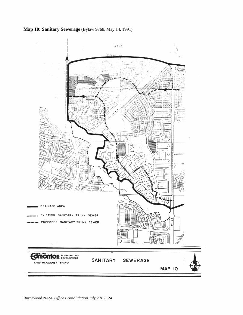
4.3 Sanitary Sewerage
Sanitary trunks with adequate capacity to service the balance of the Burnewood community are in place and presently service the developed portions of Jackson Heights, Kiniski Gardens and The Meadows. Two sanitary trunk lines extend through the north portion of Burnewood. One trunk extends from the northern portion of The Meadows area to 34 Street and Kirkwood Avenue (44A Avenue) and then along the existing collector road alignments to an existing trunk line at 44 Street and 44 Avenue. A second
Burnewood NASP Office Consolidation July 2015 20
trunk line extends from 44 Street at the pipeline corridor north to join with the north trunk line at 44 Street/Jackson Road and 44 Avenue. This trunk line then extends along 44 Avenue to 50 Street and north along 50 Street and crosses Whitemud Drive.
Extensions and branches to the existing trunk sewers will provide sanitary service to Burnewood as depicted on Map 10. Based on the findings of the Burnewood/Meadows Area Master Plan presently under review, the existing trunk from 50 Street along 44 Avenue and east to 34 Street and Kirkwood Avenue may require future upgrading in order to accommodate flows generated upstream in the northeast portion of The Meadows.
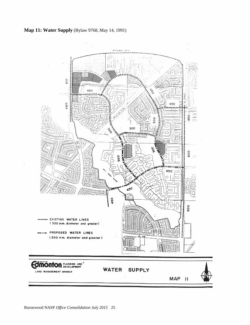
4.4 Water Supply
Water supply to the Burnewood Neighbourhood will be from the existing 450 mm diameter water mains along 34 Street and at Millwoods Road East and 38 Avenue. The supply point at 50 Street and 44 Avenue is not available due to the water supply separation zone requirement.
The water network within the Burnewood Neighbourhood shown on Map 11, running in an east-west direction, consists of an existing 450 mm diameter water main tapping off from the 450 mm diameter water main along 34 Street at 43 Avenue to 50 Street and 44 Avenue, and a future 450 mm diameter water main at Millwoods Road East and 38 Avenue, crossing the Mill Creek Ravine to tap into the existing 600 mm water main at 34 Street and 38 Avenue. In the north-east direction, it comprises two 300 mm diameter water mains interconnecting the two above mentioned 450 mm diameter water mains at 38 Street and at 45 Street.
The Mill Creek Ravine water line crossing at 38th Avenue is considered necessary by the Drainage Services Branch of the Asset Management and Public Works Department to provide for the integrity of the Burnewood/Meadows water network in the event of an interuption along 34th Street. In the absence of a 38th Avenue water line crossing, a service interuption on 34th Street would have the most impact on neighbourhoods in the Meadows. The cost of the Mill Creek Ravine water line crossing will be the responsibility of the developer. Prior to the crossing of Mill Creek Ravine an Environmental Impact Assessment would have to be completed, and this should be coordinated with the required telephone cable crossing as noted in Section 4.5, following.
Amended by Editor
Burnewood NASP Office Consolidation July 2015 21

4.5 Gas, Power and Telephone
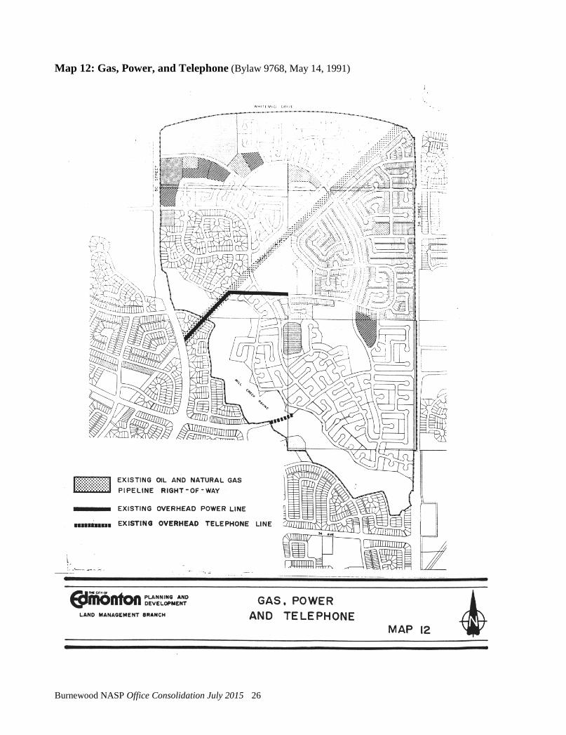
Gas, power and telephone service will be provided by extension from the existing adjacent systems. The existing temporary overhead power line, which is servicing Kiniski Gardens development, will be abandoned. As subdivision and development in this portion of Burnewood proceeds, power will be supplied by extending the underground system. A ravine crossing will not be required, and overhead power poles will be removed.
Edmonton Telephones has an overhead line crossing the Mill Creek Ravine at 38th Avenue. Edmonton Telephones will require the abandonment of the overhead line crossing Mill Creek Ravine at 38 Avenue and will provide a replacement underground ductline across the Mill Creek Ravine. Edmonton Telephones will undertake to provide an Environmental Impact Assessment and bury the telephone cable within the Ravine at such time as future development densities warrant. If possible, the Environmental Impact Assessment and crossing design should be coordinated with the water supply line crossing.
Burnewood NASP Office Consolidation July 2015 22

Map 9: Storm Drainage (Bylaw 9768, May 14, 1991)
Burnewood NASP Office Consolidation July 2015 23
Map 10: Sanitary Sewerage (Bylaw 9768, May 14, 1991)
Burnewood NASP Office Consolidation July 2015 24
Map 11: Water Supply (Bylaw 9768, May 14, 1991)
Burnewood NASP Office Consolidation July 2015 25
Map 12: Gas, Power, and Telephone (Bylaw 9768, May 14, 1991)
Burnewood NASP Office Consolidation July 2015 26
5.0 TRANSPORTATION SYSTEM
5.1 Road Network
As illustrated by Map 7, Burnewood enjoys a high level of accessibility by virtue of it being bordered by 50th Street to the west, 34th Street on the east, and the Whitemud Freeway to the north. These roadways provide excellent access for residents of Burnewood to other parts of the City.
There is an existing berm along Whitemud Drive, to which the City may, in future, add a noise attenuation wall if traffic volumes warrant. Projected traffic volumes on 34 Street and 50 Street will not warrant a noise attenuation facility. However, to improve the marketability of lots adjacent to arterials, the developer is encouraged to increase lot depths, and provide building design solutions (blank walls, triple pane glazing) to help mitigate traffic noise levels.
The collector network consists of a large internal loop with an east/west cross connection and six links extending to arterial roadways. Forty-forth Avenue will be the main collector road to serve the City lands since the deletion of 38th Avenue. Additional road access to 50th Street has been provided to serve the church in the northwest portion of the plan area. As well, additional access points have been provided at 34 Street to balance traffic flows. Local internal roads will be developed to meet current City standards and to discourage short cutting.
An intermittent top-of-bank roadway has been provided adjacent to Mill Creek Ravine to allow public access and enjoyment of the Ravine. Although not in full compliance with the City’s policy, the provision of a partial top-of-bank roadway together with a full top-of-bank walkway can be considered a reasonable interpretation of the policy for a few reasons.
First, the redesign improves the quality of the residential environment within the neighbourhood precinct. The redesign incorporates two crescent type top-of-bank loop roadways, which encourages predominantly local traffic and pedestrian friendly movement. The revisions to this roadway pattern will result in a safer, quieter residential area in that the top-of-bank roadway link, which physically separates the residential home sites from the ravine amenity, is intermittent. In the sections where the top-of-bank roadway is interrupted, the residential lots flank on the ravine adjacent to the 7.5 metre upland setback and walkway.
Bylaw 9945 March 10, 1992
Bylaw 11539 July 15, 1997
Burnewood NASP Office Consolidation July 2015 27
Secondly, with the removal of the continuous top-of-bank roadway, traffic impacts on the residents in the immediate vicinity are minimized. The top-of-bank roadway in the present plan is not an integral part of the transportation network to provide major or minor movements in and through the neighbourhood.
Boulevard landscaping and entrance gates will be incorporated into the roadway design to improve streetscape vistas. Additional road right of way adjacent to school sites will be provided to incorporate passenger drop off areas.
5.2 Transit Service
Ultimate transit routing is indicated on Map 7, and follows the collector road system. An existing transit route operates on 43 Avenue and 38 Street. Other collector roads may be used as interim transit routes.
5.3 Walkways
In addition to the road-based system, a network of walkways will be integrated into the subdivision designs, using walkway lots incorporating utility functions where feasible. These walkways will provide easy access for residents to the Mill Creek Ravine, education/recreation facilities, and bus routes.
Burnewood NASP Office Consolidation July 2015 28
6.0 SITE FEATURES
6.1 Mill Creek Ravine and Soil Stability
The most significant natural feature of this area is the Mill Creek Ravine. The Ravine delineates the south boundary of Burnewood and physically separates this community from the rest of Mill Woods. As the Ravine adds natural beauty to Burnewood and particularly Jackson Heights, the area has been designed to ensure that this feature is accessible to residents.
A soils investigation and analysis of the stability of the bank of the Ravine has been conducted by the firm of Hardy - BBT Limited. The report finds that normal development setback lines will be satisfactory.
6.2 Pipeline Corridor
A major pipeline corridor cuts across Burnewood. It is proposed that landscaping and pedestrian walkways be developed within the pipeline corridor so as to lessen the negative impacts associated with this man-made feature.
Pursuant to a recent Alberta Planning Board decision that outlines that residences be a minimum of 50 feet from the pipeline right-of-ways, greater depths have been provided for the lots adjacent to the pipeline corridor in Jackson Heights. Setbacks for multi-family uses may vary if development setbacks and fencing is provided to the satisfaction of the pipeline operator.
6.3 Vegetation
Most of the undeveloped areas have been under cultivation and therefore vegetation in the form of woodlots remains in only isolated pockets. Future homeowners will be encouraged, where practical, to preserve mature trees on their lots.
The vegetation within the Mill Creek Ravine will be retained.
6.4 Topography
As illustrated in Map 13, the topography of Burnewood can be described as a gently undulating plain. The land slopes generally to the northwest and west with an overall gradual fall of approximately 70 feet from the southeast sector to the northwest edge of the community. The topographical variations pose no real constraints to the development of the area.
Burnewood NASP Office Consolidation July 2015 29
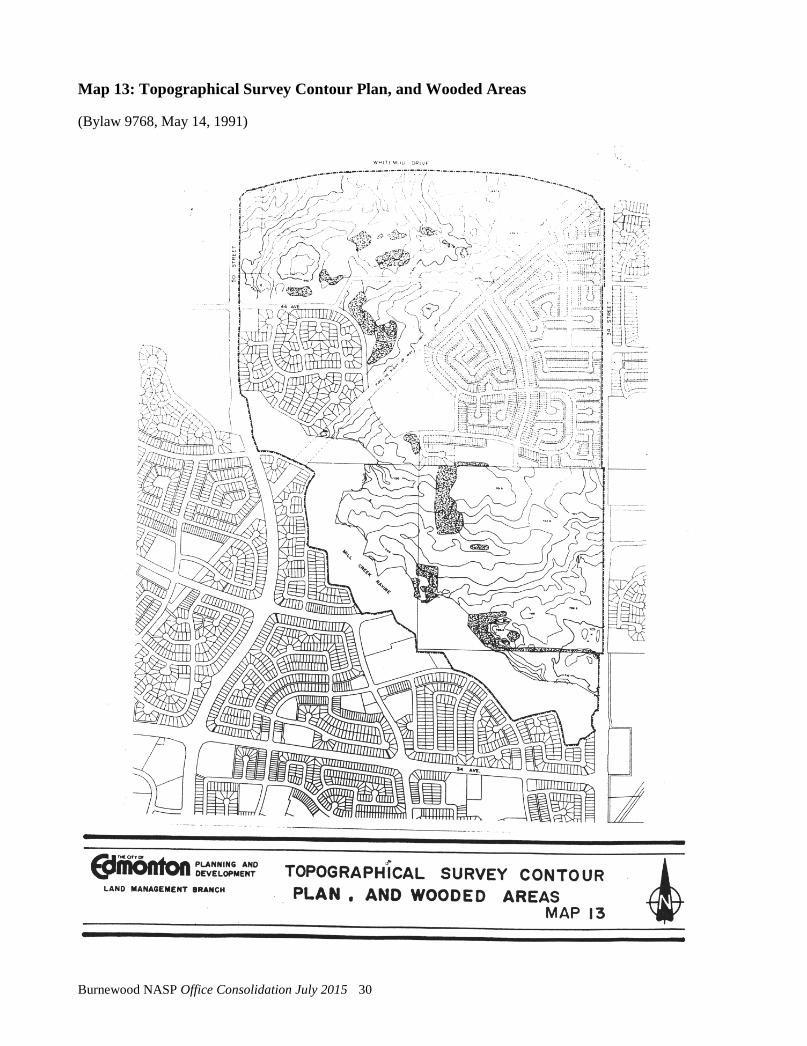
Map 13: Topographical Survey Contour Plan, and Wooded Areas
(Bylaw 9768, May 14, 1991)
Burnewood NASP Office Consolidation July 2015 30