Embed Size (px)
Citation preview
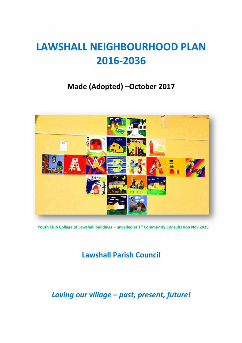
LAWSHALL NEIGHBOURHOOD PLAN 2016-2036
Made (Adopted) –October 2017
Youth Club Collage of Lawshall buildings – unveiled at 1st Community Consultation Nov 2015
Lawshall Parish Council
Loving our village – past, present, future!

CONTENTS
PART ONE Why a Neighbourhood Plan for Lawshall?................................................................... 1-15
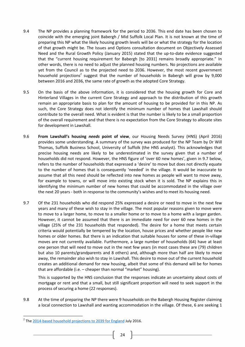
LAWSHALL at a glance........................................................................................................... 1
1. LAWSHALL present…………………………………………………………………………………………………………………….. 3
2. LAWSHALL past………………………………………………………………………………………………………………………….. 5
3. Why a Neighbourhood Plan for Lawshall? ……………………………………………………………………………….… 6
4. How we did it......……………………………………………………………………………………………………………………….. 6
5. KEY ISSUES……………………………………………………………………………………………………………………………….… 10
6. CONTEXT from National & Local Planning Policy……………………………………………………………………..... 12
7. LAWSHALL future…………………………………………………………………………………………………………………….... 13
PART TWO – Components of the Plan…………………………………………………………………….……………… 16-57
8. SETTLEMENT PATTERN & SPATIAL POLICY………………………………………………………………………………... 16
9. HOUSING development………………………………………………………………………………………………………….... 23
10. OUR NATURAL ENVIRONMENT…………………………………………………………………………………………….…. 30
11. OUR BUILT HERITAGE & DESIGN....……………………………………………………………………………………….... 39
12. OUR AMENITIES & SERVICES………………………………………………………………………………………............. 46
13. OUR INFRASTRUCTURE & BUSINESSES……………………………………………………………………………………. 49
14. IMPLEMENTATION and MONITORING……………………………………………………………………………………. 53
PROPOSALS MAP.…………………………………………………………………………………............................ 54
GLOSSARY..………………………………………………………………………………………………………………………. 56
APPENDICES & SUPPORTING DOCUMENTS................................................................................. 58-78
List of Appendices and Supporting Documents................................................................................. 58
APPENDIX ONE: Village Appraisal Summaries................................................................................... 59
APPENDIX TWO: Biodiversity in Lawshall .......................................................................................... 66
APPENDIX THREE: Listed Buildings of Lawshall................................................................................. 73
APPENDIX FOUR: Lawshall’s Buildings and Structures of Note........................................................ 75
APPENDIX FIVE: Special Traditional House Features......................................................................... 77
APPENDIX SIX: NP Team and 2nd Tier Helpers.................................................................................... 79
CONTENTS OF POLICIES AND COMMUNITY ACTIONS
POLICIES
POLICY LAW1 – Lawshall’s Settlement Planning Policy...................................................................... 20
POLICY LAW2 – Housing Development within the Built-Up Area Boundaries................................... 28
POLICY LAW3 – Housing Development outside the Built-Up Area Boundary.................................... 28
POLICY LAW4 – Housing Mix................................... .......................................................................... 29
POLICY LAW5 – Affordable Housing on Rural Exception Sites........................................................... 29
POLICY LAW6 – Important Recreation and Green Space………………………………………………………………. 33
POLICY LAW7 - Protecting Existing Natural Environmental Assets……………………….……………………….. 35
POLICY LAW8 – Protecting and Maintaining Features of Biodiversity Value………………………………….. 35
POLICY LAW9 - Settlement Gaps…………………………………………………………………………………………………… 38
POLICY LAW10 - Area of Local Landscape Sensitivity………….………………………………………………………… 38
POLICY LAW11 – Protection of Heritage Assets…………………………………………………………………………….. 41
POLICY LAW12 – Local Heritage Assets…………………………………………………………………………………………. 42
POLICY LAW13 – Design Principles……………………………………………………………………………………………….. 44
POLICY LAW14 – Community Facilities and Services…………………………………………………………………….. 47
POLICY LAW15 – Infrastructure…………………………………………………………………………………………………….. 50
POLICY LAW16 – Flood Management…………………………………………………………………………………………… 51
COMMUNITY ACTIONS
Conservation Area………………………………………………………………………………………………………………………… 42
Village Shop………………………………………………………………………………………………………………………………..… 48
Transport……………………………………………………………………………………………………………………………………… 48
Footpaths and Bridleways…………………………………………………………………………………………………………..… 48
Sports and Play Facilities................................................................................................................... 48
Parking at School………………………………………………………………………………………………………………………..… 52
Traffic and Movement around the Village………………………………………………………………………………….… 52
Flooding Risk……………………………………………………………………………………………………………………………..… 52
Improving Telephone and Broadband Service……………………………………………………………………………… 52
Your Neighbourhood Plan Team
Cathy Acheson Bryan Adams Amber Brouder (to Aug ’16)
Ric Edelman (Chair) Andy Irish (PC Cllr) John Kent Lucy Kent
Laura McClelland Tom McClelland Claire Osborne
David Page (PC Cllr from Oct ’16) Emily-Rose Debenham (from Sept ’16)
Debbie Thomas Jamie Whatley Karen Wilcox (Secretary)
Laura Williams (PC Cllr)
SPECIAL THANKS are due to....
Lawshall Parish Council who put out the call for volunteers to work on a Neighbourhood Plan (NP) and who have engaged in and supported the process throughout.
Ian Poole, our Consultant, who has gone the extra mile for us again and again.
Babergh District Council and in particular, Rachel Hogger, NP Liaison, who has unstintingly responded to our cries for help, also Bill Newman - Corporate Manager of Strategic Planning, Gill Cook - Housing Strategy Officer, Kathryn Oelman - Senior Development Management Officer, Paul Munson - Planning Consultant, Paul Bryant – Business Support Officer, and Nick Ward our initial Babergh mentor.
Dr Will Thomas who advised on and analysed the Housing Needs Survey.
Our generous funders: The Schoolhouse Fund, Groundworks and Richard Kemp - County Councillor.
David Burr and Sheridans for their excellent publicity boards.
Lawshall Youth Club for their brilliant collage and NP banner.
All Saints Primary School for inviting us to run our NP-related school project.
The Swan and Green Light Trust for pro bono use of their lovely premises for team meetings.
The Village Hall Committee for providing the perfect venue for our community events and meetings.
The NP groups in neighbouring villages who helped get us started.
And most of all our 2nd tier helpers who have done so much in so many ways - and our community members who jumped to the cause and have engaged enthusiastically from the word go!
- Lawshall NP Team for Lawshall Parish Council
1
PART ONE
Why a Neighbourhood Plan for Lawshall?
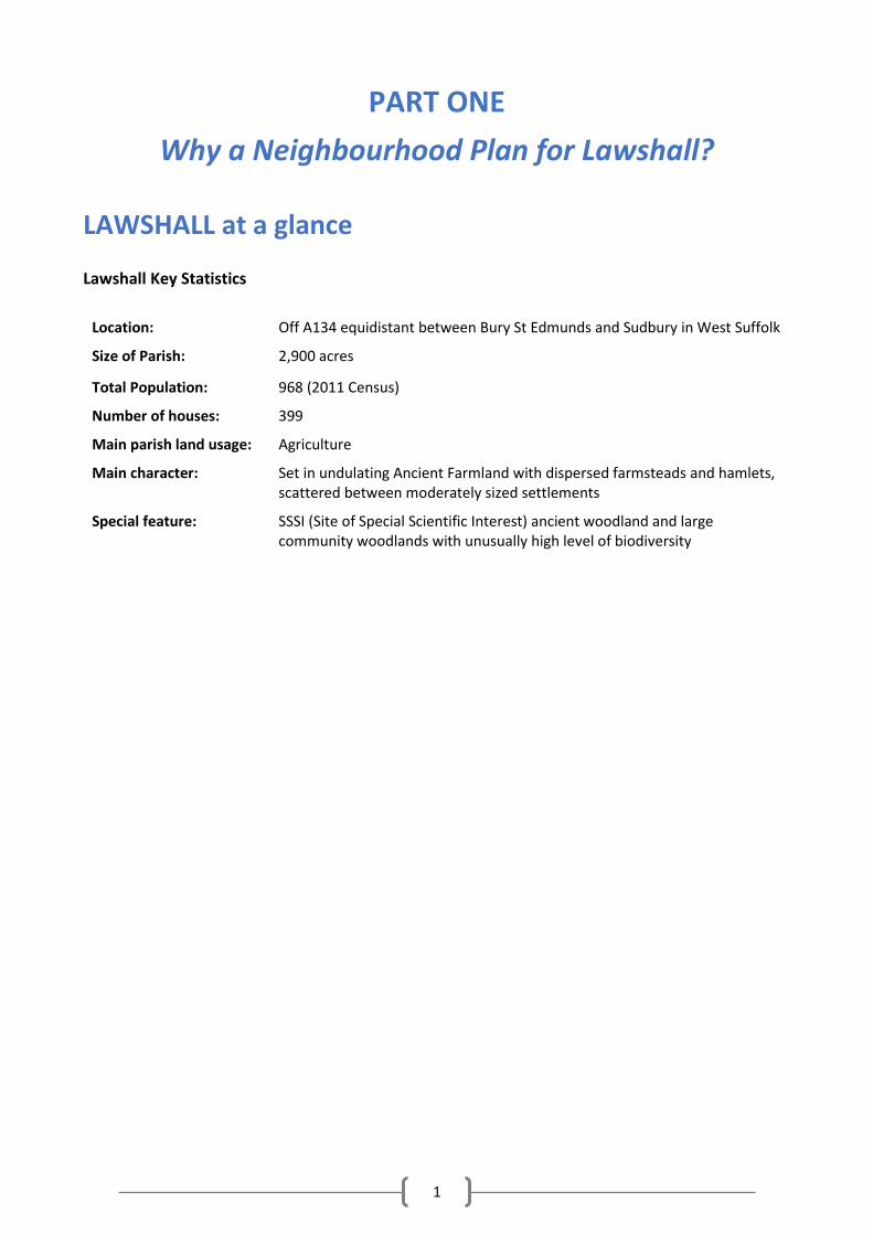
LAWSHALL at a glance
Lawshall Key Statistics
Location: Off A134 equidistant between Bury St Edmunds and Sudbury in West Suffolk
Size of Parish: 2,900 acres
Total Population: 968 (2011 Census)
Number of houses: 399
Main parish land usage: Agriculture
Main character: Set in undulating Ancient Farmland with dispersed farmsteads and hamlets, scattered between moderately sized settlements
Special feature: SSSI (Site of Special Scientific Interest) ancient woodland and large community woodlands with unusually high level of biodiversity
2
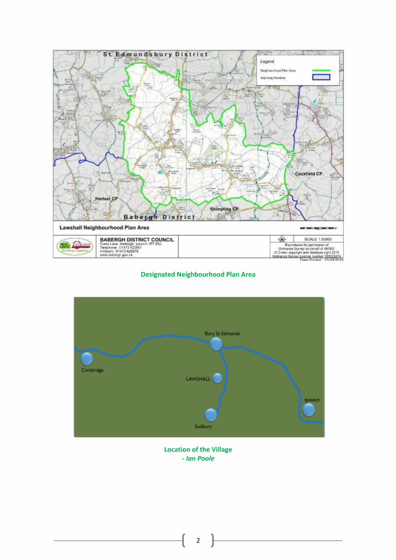
Designated Neighbourhood Plan Area
Location of the Village - Ian Poole
3
1. LAWSHALL present (NP Team character group)
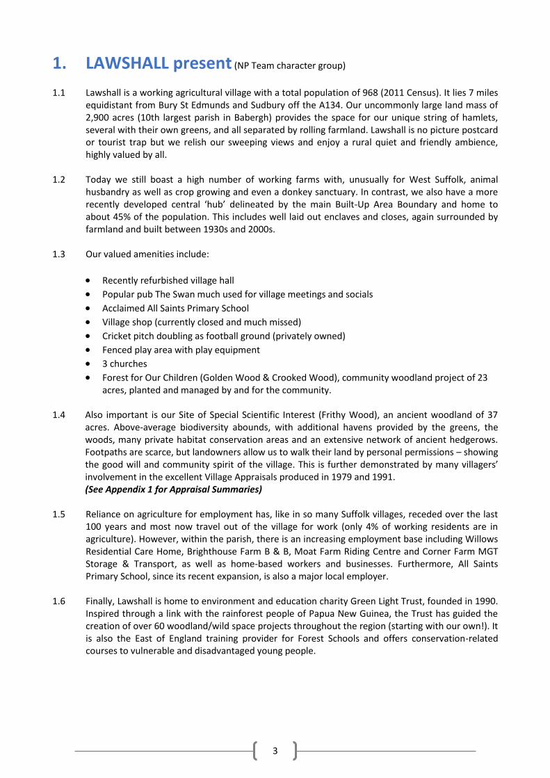
1.1 Lawshall is a working agricultural village with a total population of 968 (2011 Census). It lies 7 miles
equidistant from Bury St Edmunds and Sudbury off the A134. Our uncommonly large land mass of 2,900 acres (10th largest parish in Babergh) provides the space for our unique string of hamlets, several with their own greens, and all separated by rolling farmland. Lawshall is no picture postcard or tourist trap but we relish our sweeping views and enjoy a rural quiet and friendly ambience, highly valued by all.
1.2 Today we still boast a high number of working farms with, unusually for West Suffolk, animal
husbandry as well as crop growing and even a donkey sanctuary. In contrast, we also have a more recently developed central ‘hub’ delineated by the main Built-Up Area Boundary and home to about 45% of the population. This includes well laid out enclaves and closes, again surrounded by farmland and built between 1930s and 2000s.
1.3 Our valued amenities include:
Recently refurbished village hall
Popular pub The Swan much used for village meetings and socials
Acclaimed All Saints Primary School
Village shop (currently closed and much missed)
Cricket pitch doubling as football ground (privately owned)
Fenced play area with play equipment
3 churches
Forest for Our Children (Golden Wood & Crooked Wood), community woodland project of 23 acres, planted and managed by and for the community.
1.4 Also important is our Site of Special Scientific Interest (Frithy Wood), an ancient woodland of 37
acres. Above-average biodiversity abounds, with additional havens provided by the greens, the woods, many private habitat conservation areas and an extensive network of ancient hedgerows. Footpaths are scarce, but landowners allow us to walk their land by personal permissions – showing the good will and community spirit of the village. This is further demonstrated by many villagers’ involvement in the excellent Village Appraisals produced in 1979 and 1991. (See Appendix 1 for Appraisal Summaries)
1.5 Reliance on agriculture for employment has, like in so many Suffolk villages, receded over the last 100 years and most now travel out of the village for work (only 4% of working residents are in agriculture). However, within the parish, there is an increasing employment base including Willows Residential Care Home, Brighthouse Farm B & B, Moat Farm Riding Centre and Corner Farm MGT Storage & Transport, as well as home-based workers and businesses. Furthermore, All Saints Primary School, since its recent expansion, is also a major local employer.
1.6 Finally, Lawshall is home to environment and education charity Green Light Trust, founded in 1990.
Inspired through a link with the rainforest people of Papua New Guinea, the Trust has guided the creation of over 60 woodland/wild space projects throughout the region (starting with our own!). It is also the East of England training provider for Forest Schools and offers conservation-related courses to vulnerable and disadvantaged young people.
4
Harvest view Melford Road - N Hughes
Swan Inn - L Williams
Gate & West Farm Donkey Sanctuary - A Staveley
All Saints Primary School - E Clarke
5
2. LAWSHALL past (L Bell / S Haffenden, Hanningfield Green)
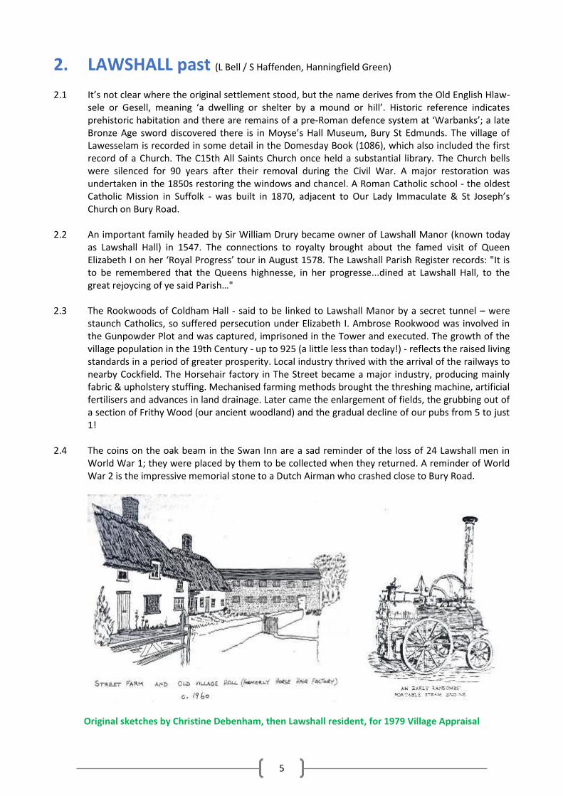
2.1 It’s not clear where the original settlement stood, but the name derives from the Old English Hlaw-
sele or Gesell, meaning ‘a dwelling or shelter by a mound or hill’. Historic reference indicates prehistoric habitation and there are remains of a pre-Roman defence system at ‘Warbanks’; a late Bronze Age sword discovered there is in Moyse’s Hall Museum, Bury St Edmunds. The village of Lawesselam is recorded in some detail in the Domesday Book (1086), which also included the first record of a Church. The C15th All Saints Church once held a substantial library. The Church bells were silenced for 90 years after their removal during the Civil War. A major restoration was undertaken in the 1850s restoring the windows and chancel. A Roman Catholic school - the oldest Catholic Mission in Suffolk - was built in 1870, adjacent to Our Lady Immaculate & St Joseph’s Church on Bury Road.
2.2 An important family headed by Sir William Drury became owner of Lawshall Manor (known today
as Lawshall Hall) in 1547. The connections to royalty brought about the famed visit of Queen Elizabeth I on her ‘Royal Progress’ tour in August 1578. The Lawshall Parish Register records: "It is to be remembered that the Queens highnesse, in her progresse...dined at Lawshall Hall, to the great rejoycing of ye said Parish…"
2.3 The Rookwoods of Coldham Hall - said to be linked to Lawshall Manor by a secret tunnel – were
staunch Catholics, so suffered persecution under Elizabeth I. Ambrose Rookwood was involved in the Gunpowder Plot and was captured, imprisoned in the Tower and executed. The growth of the village population in the 19th Century - up to 925 (a little less than today!) - reflects the raised living standards in a period of greater prosperity. Local industry thrived with the arrival of the railways to nearby Cockfield. The Horsehair factory in The Street became a major industry, producing mainly fabric & upholstery stuffing. Mechanised farming methods brought the threshing machine, artificial fertilisers and advances in land drainage. Later came the enlargement of fields, the grubbing out of a section of Frithy Wood (our ancient woodland) and the gradual decline of our pubs from 5 to just 1!
2.4 The coins on the oak beam in the Swan Inn are a sad reminder of the loss of 24 Lawshall men in
World War 1; they were placed by them to be collected when they returned. A reminder of World War 2 is the impressive memorial stone to a Dutch Airman who crashed close to Bury Road.
Original sketches by Christine Debenham, then Lawshall resident, for 1979 Village Appraisal
6
Original sketches by Christine Debenham, then Lawshall resident, for 1979 Village Appraisal
3. Why a Neighbourhood Plan for Lawshall?
Because it gives us the opportunity to provide a Lawshall-specific context to inform Babergh’s planning decisions.
Because we've been designated as a Hinterland Village and, as such, will be expected to accommodate our fair share of the new housing that Babergh needs.
Because we want a say in what any new housing should look like and who it should be for.
Because we have our own pressing housing needs to address.
Because we want to ensure there remain sufficient village services and amenities.
Because additional funds may be made available under CIL (the Community Infrastructure Levy) which could be used to enhance and improve such services and amenities.
Because we want to protect what our community values most about our parish.
Because we want our children and grandchildren to inherit what we enjoy today!
4. How we did it... (L McClelland, Lawshall Green)
4.1 By building a strong NP Team - Lawshall is a friendly spread-out village and this is perfectly
reflected in our 15 person-strong NP Team. We come from all over the village and all walks of life, including three representatives from the Parish Council. We also have a large group of ‘2nd tier’ helpers to call on whenever we need them. To guide our activity we put together a Mission Statement, Terms of Reference, Community Engagement Strategy and Complaints Procedure (for any villager unhappy with the process). (See Supporting Documents and Appendix 6)
4.2 By in-depth community engagement - We’ve come up with lots of different ways to engage and
stay engaged with our community at every step of our journey – much more in fact than the NP
7
regulations require! These include: public consultation events, questionnaires, school project, village walk, stalls at fetes, Christmas tree competition, tab on the Parish Council website, Facebook group, Twitter feed, monthly articles in parish magazine, door-to-door fliers, posters, and presentations to local groups. We’ve produced a separate Consultation Statement identifying the details of the engagement we’ve undertaken and how it’s shaped what’s in the Plan. (See Supporting Documents)
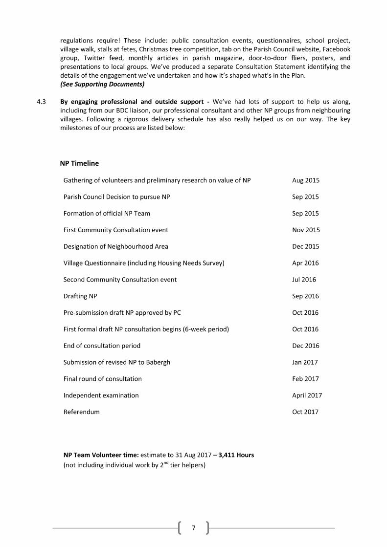
4.3 By engaging professional and outside support - We’ve had lots of support to help us along,
including from our BDC liaison, our professional consultant and other NP groups from neighbouring villages. Following a rigorous delivery schedule has also really helped us on our way. The key milestones of our process are listed below:
NP Timeline
Gathering of volunteers and preliminary research on value of NP Aug 2015
Parish Council Decision to pursue NP Sep 2015
Formation of official NP Team Sep 2015
First Community Consultation event Nov 2015
Designation of Neighbourhood Area Dec 2015
Village Questionnaire (including Housing Needs Survey) Apr 2016
Second Community Consultation event Jul 2016
Drafting NP Sep 2016
Pre-submission draft NP approved by PC Oct 2016
First formal draft NP consultation begins (6-week period) Oct 2016
End of consultation period
Submission of revised NP to Babergh
Dec 2016
Jan 2017
Final round of consultation
Independent examination
Referendum
Feb 2017
April 2017
Oct 2017
NP Team Volunteer time: estimate to 31 Aug 2017 – 3,411 Hours
(not including individual work by 2nd tier helpers)
8
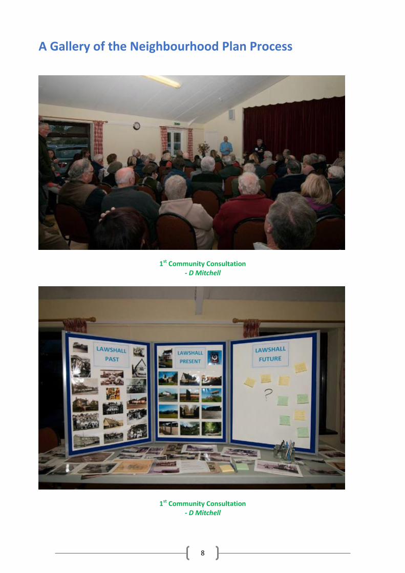
A Gallery of the Neighbourhood Plan Process
1st Community Consultation - D Mitchell
1st Community Consultation - D Mitchell
9
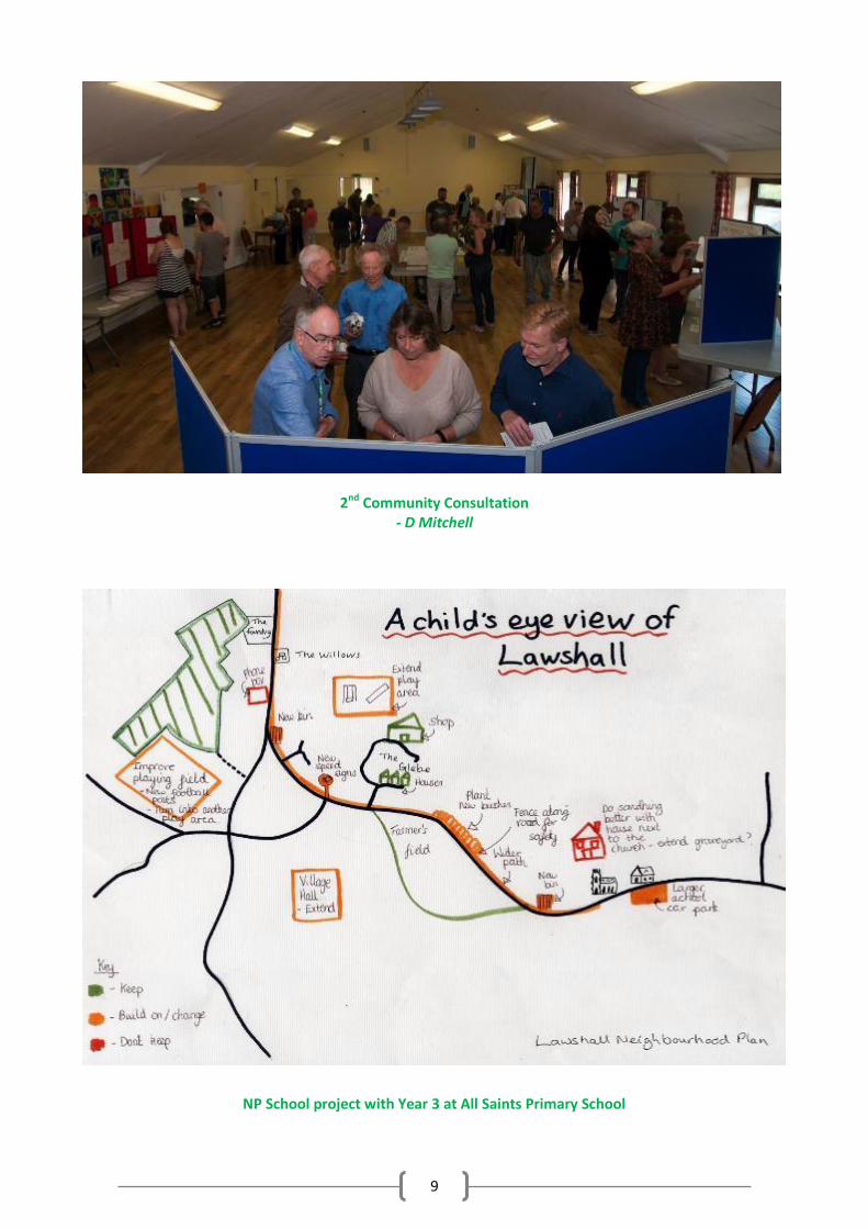
2nd Community Consultation - D Mitchell
NP School project with Year 3 at All Saints Primary School
10
5. KEY ISSUES
5.1 The NP Team’s aim throughout has been to be merely facilitators and enablers in making the Plan 100% community led. Thus everything has been built on the comments, views, concerns and wishes of everyone who’s participated in the process. From the outset, and supported by the results of our 1st community consultation, the following issues have been highlighted and stressed. Some are echoes from the Village Appraisals of 1979 and 1991, while others are newly arisen:
5.2 In response to these issues, the NP Team undertook several key pieces of work to gather more
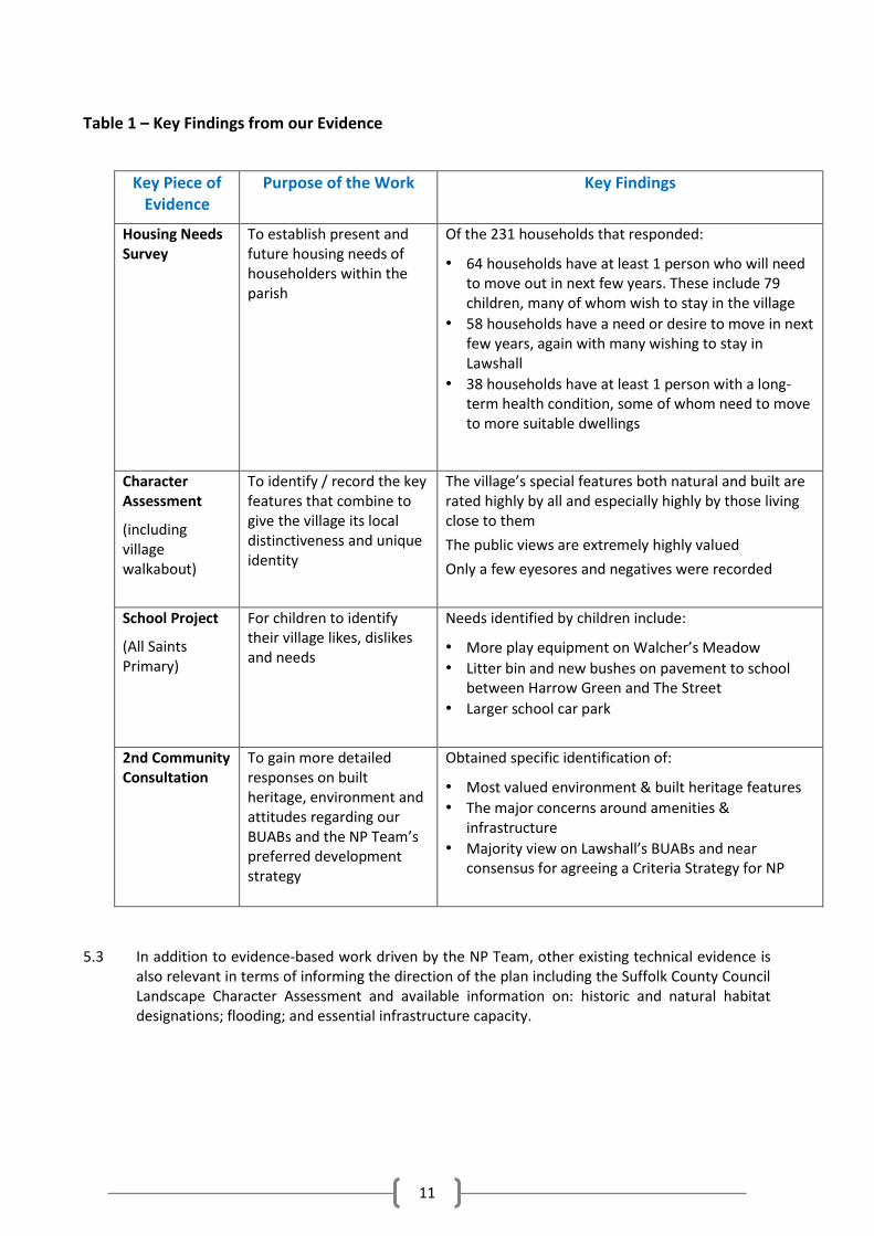
information to inform the appropriate direction of the Plan. Though our findings are dealt with in more detail in the relevant sections of Part Two, an overview is given in Table 1.
Natural Environment: Strong desire to maintain our open spaces, woodlands, hedgerows, biodiversity and much-loved views. Concern at lack of public footpaths. Built Heritage: Strong desire to protect our Listed Buildings and other locally distinctive buildings of note. Housing: Major concern over the number of houses the village will be expected to accommodate. Strong reluctance towards large blocks of new housing. Majority vote not to increase our designated Built-Up Area Boundaries (BUABs). Concern that future expansion will damage the village’s key characteristics. Need for smaller family homes. Need for improved housing provision for young people and the 197 elderly. Amenities: Major concern at the recent loss of our much-valued shop (Glebe Minimarket). Need for better sports facilities and play areas. Strong feelings both for and against street lighting. Infrastructure and businesses: Three burning issues raised around a) lack of parking for recently enlarged primary school b) occurrences of serious flooding to properties and c) lack of adequate internet/phone communications.
11
Table 1 – Key Findings from our Evidence
Key Piece of Evidence
Purpose of the Work Key Findings
Housing Needs Survey
To establish present and future housing needs of householders within the parish
Of the 231 households that responded:
• 64 households have at least 1 person who will need to move out in next few years. These include 79 children, many of whom wish to stay in the village
• 58 households have a need or desire to move in next few years, again with many wishing to stay in Lawshall
• 38 households have at least 1 person with a long-term health condition, some of whom need to move to more suitable dwellings
Character Assessment
(including village walkabout)
To identify / record the key features that combine to give the village its local distinctiveness and unique identity
The village’s special features both natural and built are rated highly by all and especially highly by those living close to them
The public views are extremely highly valued
Only a few eyesores and negatives were recorded
School Project
(All Saints Primary)
For children to identify their village likes, dislikes and needs
Needs identified by children include:
• More play equipment on Walcher’s Meadow
• Litter bin and new bushes on pavement to school between Harrow Green and The Street
• Larger school car park
2nd Community Consultation
To gain more detailed responses on built heritage, environment and attitudes regarding our BUABs and the NP Team’s preferred development strategy
Obtained specific identification of:
• Most valued environment & built heritage features
• The major concerns around amenities & infrastructure
• Majority view on Lawshall’s BUABs and near consensus for agreeing a Criteria Strategy for NP
5.3 In addition to evidence-based work driven by the NP Team, other existing technical evidence is
also relevant in terms of informing the direction of the plan including the Suffolk County Council Landscape Character Assessment and available information on: historic and natural habitat designations; flooding; and essential infrastructure capacity.
12
6. CONTEXT from National & Local Planning Policy
Basic Conditions
6.1 A Neighbourhood Plan must achieve the following if it is to be what is known as “made” (i.e. adopted). It must:
(a) Have regard to national policies and advice contained in guidance by the Secretary of State;
(b) Contribute to the achievement of sustainable development; (c) Be in general conformity with the strategic policies contained in the Babergh Local Plan; (d) Not breach, and be otherwise compatible with, EU obligations (regardless of the recent
BREXIT vote).
These are known as the “Basic Conditions” that the content and policies of the Neighbourhood Plan are examined against.
NPPF
6.2 The government’s National Planning Policy Framework (NPPF) must be taken into account in the preparation of Neighbourhood Plans and it is a “material consideration” when Babergh make decisions on planning applications. It therefore requires that communities preparing Neighbourhood Plans should:
• develop plans that support the strategic development needs set out in Local Plans, including policies for housing and economic development;
• plan positively to support local development, shaping and directing development in their area that is outside the strategic elements of the Local Plan; and
• identify opportunities to use Neighbourhood Development Orders to enable developments that are consistent with their Neighbourhood Plan to proceed (NPPF para 16)1
Babergh District Council Planning Policies
6.3 At a more local level, the development plan comprises the Core Strategy and the “saved policies” of the 2006 Babergh Local Plan. Babergh District Council adopted its Core Strategy (new local plan) in February 2014. It provides the current strategic planning framework for Lawshall which this Neighbourhood Plan has had regard to.
6.4 The Core Strategy identifies Lawshall as a “hinterland village” within the “functional cluster” of Long Melford. What this means is that within the district there is a hierarchy of settlements ranked according to their size and the services they provide. The Core Strategy recognises that there are a number of larger villages (core villages) that provide a range of services and facilities for a cluster of villages around them. However, the reality is that Bury St Edmunds is as close to most parts of the village as is Long Melford and provides a greater range of services and jobs. Insofar as Lawshall is concerned, the policies set out in the 2014 Core Strategy and the saved policies of the 2006 Local Plan are those by which planning applications will be judged.
6.5 In 2015 the District Council commenced the preparation of a new joint local plan in conjunction with Mid Suffolk. The local plan would run to 2036 and an initial round of consultation suggested that the required housing growth rate in Babergh would be similar to the current rate of growth planned for in the 2014 Core Strategy. At this time the joint local plan is at a very early stage in preparation and, therefore, is not a matter which has been given weight in the preparation of this Neighbourhood Plan.
1 https://www.gov.uk/government/uploads/system/uploads/attachment_data/file/6077/2116950.pdf16
13
7. LAWSHALL future (NP Team Vision group)
7.1 Our living vision reflects how Lawshall will look in 2036. It is imagined wholly from residents’
comments gathered from our consultations. At the same time it is mindful of statutory demands and the efficacy of remaining in harmony with Babergh’s Local Plan and Core Strategy. We envisage that:
Village Character
The rural nature of our village will have been preserved - with its winding lanes, rolling fields, wide views and distinct hamlets some of which, as today, will still have their own greens.
Family farms will still abound and the tranquil setting, dark night skies and rural feel will still be intact.
Frithy Wood and Forest for Our Children (Golden Wood & Crooked Wood) will be even more abundant with wildlife and boast even higher and more enviable biodiversity.
Amenities and Services
Those amenities and services most valued today will still be ‘alive and well’ and, where appropriate, up-graded for everyone’s benefit and enjoyment.
We will long have had a thriving village shop again and the sports and play facilities will have been improved and expanded.
Historic Heritage
Preservation of our built heritage will still be of key importance and this will be reflected in traditional features being incorporated into some of our new homes.
New Housing
This will have not exceeded what can be comfortably absorbed without destroying the parish’s rural fabric and character.
It will have been built within or adjoining the defined built-up areas or as sensitive and proportional infillings within the identified clusters (hamlets).
Infrastructure
The school parking issues troubling today will long ago have been solved.
Internet and phone communication systems will be up to speed and will have encouraged small rural set-ups and new local businesses.
Solutions to flooding issues will have been achieved and flooding will be a problem of the past. Youth
Last but not least - we will have listened to the needs of our young people and suitable accommodation will have been built for them.
Those who wished to, will have been able to remain in the village – thereby ensuring that in 2036 there will still be a continuance of diverse demographics and a lively thriving village community enjoyed by all!
14
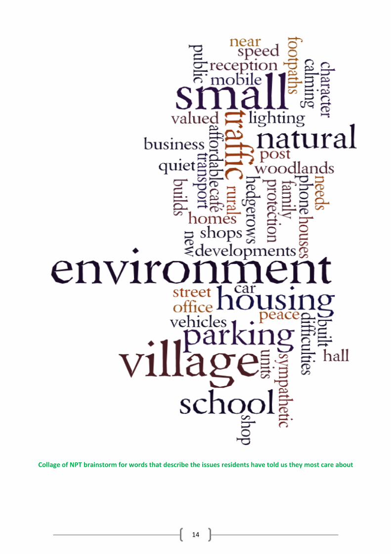
Collage of NPT brainstorm for words that describe the issues residents have told us they most care about
15
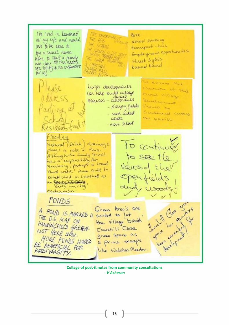
Collage of post-it notes from community consultations
- V Acheson
16
PART TWO
Components of the Plan
8. SETTLEMENT PATTERN & SPATIAL POLICY 8.1 Lawshall’s settlement pattern is a series of hamlets connected by open countryside. Five of the
hamlets have their own greens and a number of dwellings. There is a more densely populated area in the centre of the village around the village hall, and also around the school and pub. This settlement pattern contributes significantly to the character of the village.
8.2 Babergh’s Core Strategy Policy CS2 designates Lawshall as a Hinterland Village which will:
“accommodate some development to meet the needs within them” and where “All proposals will be assessed against Policy CS11.”
8.3 Core Strategy Policy CS11 has three key strands to it that are relevant to setting the policy context
to the Lawshall Neighbourhood Plan. In summary, it states that development proposals will be approved where:
i. proposals score positively when assessed against Policy CS15; ii. a series of matters (which are set out in the table below) are addressed; and
iii. proposals are able to demonstrate a close functional relationship to the existing settlement sites.
8.4 To expand further on the first two points above:
i) Assessment against Policy CS15: With regards to the first of these, Policy CS15 provides a comprehensive set of 19 criteria. The policy states that “All new development within the district, will be required to demonstrate the principles of sustainable development and will be assessed against the presumption in favour of sustainable development……”
The following context, as evidenced by national data and local appraisals and studies, is relevant to the 19 criteria set out in Policy CS15:
• Lawshall is rich in environmental, historic and architectural assets. • Lawshall’s ancient hedgerows, ancient and community woodlands, wildflower meadows,
greens, organic agricultural fields and large number of private gardens, ensures a high level of biodiversity. There are many rare species of birds, butterflies and wildflowers in the village, as reported in Appendix 2.
• Walcher’s Meadow, including its playground, Churchill Close Meadow, Golden, Frithy and Crooked Woods all provide access to open space for children’s play, walkers and dog walkers.
• Whilst Lawshall is not within the fluvial or tidal flood plain, it does experience localised problems related to surface water flooding as identified in Suffolk County Council Flood Investigations Reports. In September 2014, there was, for example, an incident where flooding occurred to properties and roads from a combination of surface water and sewage discharge. Appropriate measures would need to be in place to accommodate any additional housing to ensure no further risk to both existing and new properties.
ii) Matters in CS11: The matters which Policy CS11 specifies should be addressed are set out below, together with a summary of the related Lawshall-specific context. More detail on Lawshall-specific context is provided in the individual policy sections.
17
The Lawshall-specific context against the Core Strategy CS11 criteria (site location and sequential approach to development):
The Core Strategy states that “Proposals will be approved where the following matters are addressed, where relevant and appropriate to the scale and location of the proposal:”
CS11 Criteria NP Response
i) the landscape, environment and heritage characteristics of the village
The Lawshall Character Assessment has identified
Important open spaces
Ancient hedgerows
Areas of environmental importance
Treasured views
A part of the parish is designated as Special Landscape Area by Babergh Local Plan (2006) Saved Policies.
The Suffolk Landscape Character Assessments shows that Lawshall falls largely within the landscape character type of Undulating Ancient Farmland (a landscape of open undulating farmland with blocks of ancient woodland). The Suffolk Landscape Character Assessment Management Guidelines for this landscape typology states “parishes in this landscape tend to consist of multiple clusters of varying sizes. The release of land for development should, if at all possible, reflect the local pattern. Ribbon development destroys this pattern and can have a considerable impact on the wider landscape”.
ii) the locational context of the village and the proposed development (particularly the AONBs, Conservation Areas and heritage assets)
Lawshall has many protected areas and buildings:
Frithy Wood is a SSSI ancient woodland;
Hanningfield Green is a County Wildlife Site;
Folly Lane has a protected hedge and a separate small protected woodland;
there is a Scheduled Ancient Monument moated site at New House farm on Shimpling Road;
there are several tree preservation orders near Lawshall’s other moated, but unlisted site;
there are 27 listed buildings, all of which are Grade 2 apart from Lawshall Hall which is Grade 2* and All Saints Church which is Grade 1.
iii) site location and sequential approach to site selection
Lawshall’s settlement pattern is a series of hamlets connected by open countryside. There is a more densely populated area in the centre of the village. Lawshall has 3 main settlement areas which are contained within designated Built Up Area Boundaries (BUABs) as per the saved policies of the 2006 Local Plan:
part of Bury Road;
the area stretching from the Glebe to Lambs Lane and Churchill Close;
part of The Street.
Further smaller settlement areas are located outside the (BUAB). There are limited opportunities for acceptable infill within these smaller settlements. There are also some opportunities for development adjacent to the BUABs. However, some locations adjacent to the BUABs are environmentally sensitive. In addition, extension of ribbon development can be damaging to the existing character and wider landscape. New development should reflect the existing settlement pattern of the village and this may mean, in some instances, locations outside the BUABs are preferable to locations adjacent to the BUABs.
iv) locally identified need - housing and employment, and specific local needs such
• 64 Lawshall households have at least 1 person who will need to move out in next few years incl. 79 children, many of whom wish to stay in village.
• 58 households have a need or desire to move in next few years, again with many wishing to stay in Lawshall but needing smaller family home which are not available.
18
as affordable housing • 38 households have at least 1 person with a long-term health condition and some need to move to more suitable dwellings.
• There are 9 households on the Babergh Housing Register claiming a local connection to Lawshall and wanting accommodation in the village. Of the 9, 6 are registered for 1 bed affordable accommodation and 3 are registered for 2 bed affordable accommodation.
Thus there is an urgent need for low cost or ‘affordable’ housing for young people/first- time buyers and some need for easy-access one storey dwellings and sheltered accommodation.
There is also a need for more employment in the village, currently limited by lack of small businesses & enterprises, which are, in turn, hampered by poor communications and absence of suitable premises.
v) locally identified community needs
Provision of much-missed and much-needed village shop, following recent closure; either by blocking change of use of shop premises, or supporting new shop venue.
Provision of robust road and pedestrian safety measures at and around our recently expanded All Saints Primary School, as well as urgently needed off-road parking for all users of the school.
Provision of improved infrastructure and safeguards to prevent further flooding to properties that have already suffered severe flooding damage.
Provision of better internet/telephone network communications for all villagers, and to encourage home-workers and appropriately-sized new businesses and enterprises.
Provision of improved sports facilities and play areas for all.
Provision of improved public transport to Bury St Edmunds, especially for young people, the elderly, and those without private transport.
vi) cumulative impact of development in the area in respect of social, physical and environmental impacts
There are concerns about the infrastructure required to support the school, in particular, parking.
There is limited capacity in our foul sewerage network, pumping stations and the treatment plant at Shimpling.
Our country lanes are susceptible to damage and a change of character resulting from an increase in traffic
In addition to the above, development in hinterland villages must also:
i) be well designed and appropriate in size/scale, layout and character to its setting and to the village
Lawshall has a large number of listed buildings and buildings of architectural significance – more details in the Built Heritage section and in the Character Assessment. The majority of properties have mid-sized to large gardens and countryside views. There are a variety of design styles and sizes of homes.
ii) is adjacent or well related to the existing pattern of development for that settlement
Lawshall’s settlement pattern of a series of hamlets connected by open countryside places restraints on site location. See analysis under iii) above. Some areas adjacent to the BUABs would not be appropriate for new development due to the risk that ribbon development can have an impact on the wider landscape and also on the Settlement Gaps that have been identified to protect favourite views and keep the individual hamlets distinct.
iii) meets a proven local need, such as affordable housing or targeted market housing identified in an adopted community local plan / neighbourhood plan
Lawshall’s proven local needs are laid out in iv) opposite as based on the results of the 2016 Housing Needs Survey:
need for suitable ‘affordable’ or other form of low cost accommodation for local young people and others on low income;
need for smaller family homes for locals to downsize and a few larger homes for locals to up-size;
need for a few easy-access one-storey dwellings and some sheltered accommodation.
19
According to strong votes in the community, this local need for growth (as evidenced through the village questionnaire and 2 community consultations) should be met with a combination of small groups of up to 5 houses and proportional in-filling within the current housing areas.
iv) supports local services and/or creates or expands employment opportunities; and
Paragraph v) opposite outlines the support needed for local services and employment. Most important of these are a) the need to protect the closed shop premises or provide an alternative venue for a hoped-for reopening in the future and b) to support the solving of the congestion problem at the school with safety measures for pedestrians and off-road parking for school users.
v) does not compromise the delivery of permitted or identified schemes in adopted community/village local plans within the same functional cluster
There is no other current village plan for Lawshall and there is nothing in the NP that is substantially contrary to villagers’ comments from the village appraisals of 1979 and 1991.
8.5 With regards the third strand to CS11 (site location and sequential approach to development), the
supporting text to Policy CS11 clarifies that the Built-Up Area Boundaries (BUABs) defined in the 2006 Local Plan Saved Policies provide a useful starting point when considering the relationship of proposed development in relation to the existing pattern of development. The policy however allows for a degree of flexibility for settlements such as Lawshall where clusters of development exist outside the BUABs on the one hand and where there might be areas of land adjacent to the BUABs not appropriate for development.
8.6 The rationale behind the Settlement Pattern Policy is to provide an overarching approach to all
types of development proposals that may come forward during the plan period. The intention is that it provides clarity to the application of Core Strategy Policies CS2 and CS11.
8.7 It is considered that the existing settlement pattern contributes significantly to the character of the
village and that it should therefore be retained. On the basis of the criteria in Policy CS11 the focus for future development will continue to be within the BUABs. However, recognising that opportunities for new development within the BUABs are limited and, in accordance with the strategic approach in the Core Strategy, new development adjacent to the BUAB will be supported where there are no environmental constraints, such as identified settlement gaps, and where there’ll be no adverse impacts on wider landscape resulting from, for example, ribbon development.
8.8 Beyond the BUABs and reflecting the historic settlement pattern of the area, there are
opportunities for supporting new development within other distinct clusters of homes, where it can be demonstrated that the proposals relate well to existing patterns of development. The following hamlets are therefore considered suitable for sensitive infilling as defined under Policy LAW1 and Policy LAW3: • Harrow Green; • Hanningfield Green; • Hibbs Green; • Lawshall Green; and • Audley End.
8.9 It is essential that all development proposals are small in scale in order to be appropriate to the
setting and scale of their immediate surroundings. See section 8 for provisions specific to residential development.
20
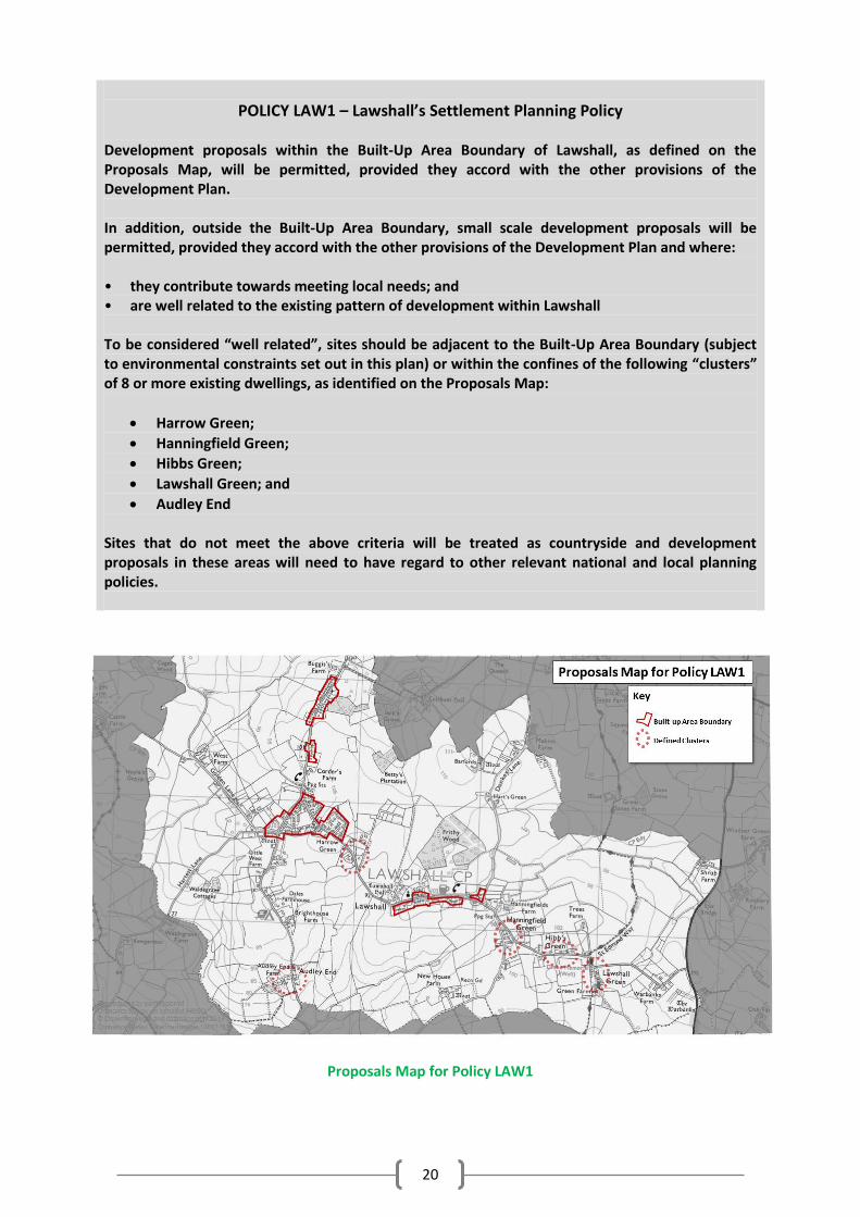
POLICY LAW1 – Lawshall’s Settlement Planning Policy Development proposals within the Built-Up Area Boundary of Lawshall, as defined on the Proposals Map, will be permitted, provided they accord with the other provisions of the Development Plan. In addition, outside the Built-Up Area Boundary, small scale development proposals will be permitted, provided they accord with the other provisions of the Development Plan and where: • they contribute towards meeting local needs; and • are well related to the existing pattern of development within Lawshall To be considered “well related”, sites should be adjacent to the Built-Up Area Boundary (subject to environmental constraints set out in this plan) or within the confines of the following “clusters” of 8 or more existing dwellings, as identified on the Proposals Map:
Harrow Green;
Hanningfield Green;
Hibbs Green;
Lawshall Green; and
Audley End Sites that do not meet the above criteria will be treated as countryside and development proposals in these areas will need to have regard to other relevant national and local planning policies.
Proposals Map for Policy LAW1
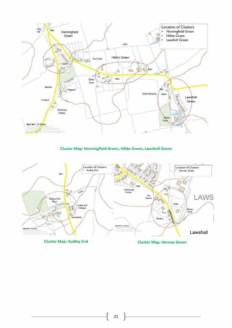
21
Cluster Map: Hanningfield Green, Hibbs Green, Lawshall Green
Cluster Map: Audley End
Cluster Map: Harrow Green
22
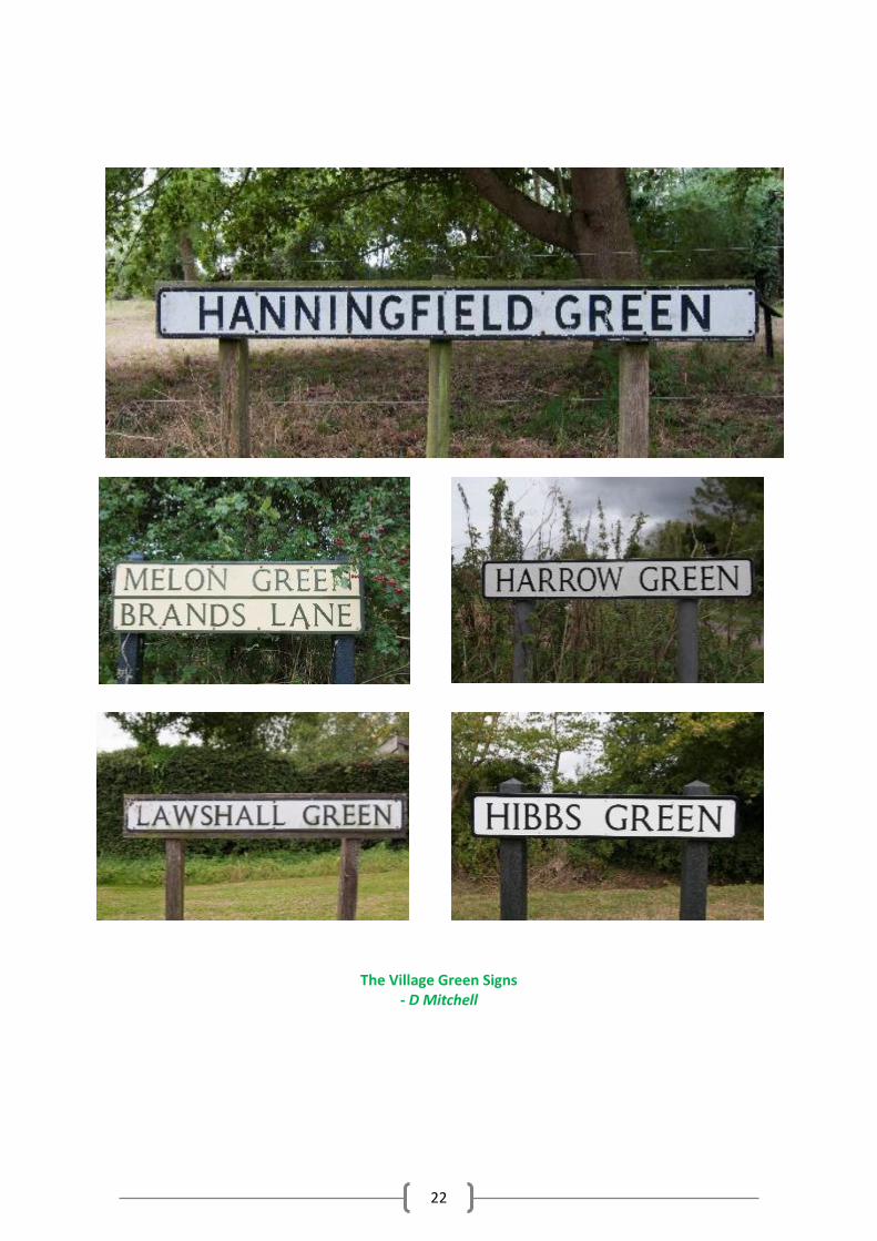
The Village Green Signs
- D Mitchell
23
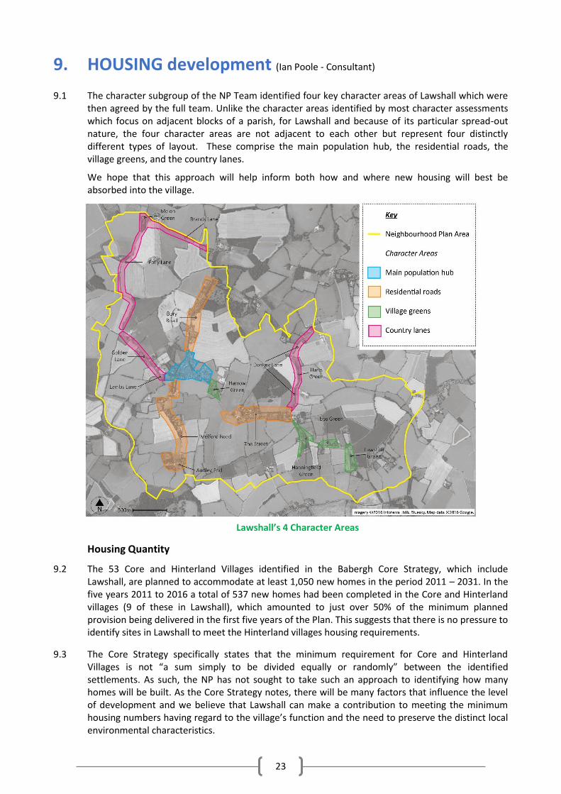
9. HOUSING development (Ian Poole - Consultant)
9.1 The character subgroup of the NP Team identified four key character areas of Lawshall which were
then agreed by the full team. Unlike the character areas identified by most character assessments which focus on adjacent blocks of a parish, for Lawshall and because of its particular spread-out nature, the four character areas are not adjacent to each other but represent four distinctly different types of layout. These comprise the main population hub, the residential roads, the village greens, and the country lanes.
We hope that this approach will help inform both how and where new housing will best be absorbed into the village.
Lawshall’s 4 Character Areas
Housing Quantity
9.2 The 53 Core and Hinterland Villages identified in the Babergh Core Strategy, which include Lawshall, are planned to accommodate at least 1,050 new homes in the period 2011 – 2031. In the five years 2011 to 2016 a total of 537 new homes had been completed in the Core and Hinterland villages (9 of these in Lawshall), which amounted to just over 50% of the minimum planned provision being delivered in the first five years of the Plan. This suggests that there is no pressure to identify sites in Lawshall to meet the Hinterland villages housing requirements.
9.3 The Core Strategy specifically states that the minimum requirement for Core and Hinterland Villages is not “a sum simply to be divided equally or randomly” between the identified settlements. As such, the NP has not sought to take such an approach to identifying how many homes will be built. As the Core Strategy notes, there will be many factors that influence the level of development and we believe that Lawshall can make a contribution to meeting the minimum housing numbers having regard to the village’s function and the need to preserve the distinct local environmental characteristics.
24
9.4 The NP provides a planning framework for the period to 2036. This end date has been chosen to
coincide with the emerging joint Babergh / Mid Suffolk Local Plan. It is not known at the time of preparing this NP what the likely housing growth levels will be or what the strategy for the location of that growth might be. The Issues and Options consultation document on Objectively Assessed Need and the Rural Growth Policy (January 2015) stated that the up-to-date evidence suggested that the “current housing requirement for Babergh [to 2031] remains broadly appropriate.” In other words, there is no need to adjust the planned housing numbers. No projections are available yet from the Council as to the projected need to 2036. However, the most recent government household projections2 suggest that the number of households in Babergh will grow by 9,000 between 2016 and 2036, the same rate of growth as the adopted Core Strategy.
9.5 On the basis of the above information, it is considered that the housing growth for Core and
Hinterland Villages in the current Core Strategy and approach to the distribution of this growth remain an appropriate basis to plan for the amount of housing to be provided for in this NP. As such, the Core Strategy does not identify the minimum number of homes that Lawshall should contribute to the overall need. What is evident is that the number is likely to be a small proportion of the overall requirement and that there is no expectation from the Core Strategy to allocate sites for development in Lawshall.
9.6 From Lawshall’s housing needs point of view, our Housing Needs Survey (HNS) (April 2016)
provides some understanding. A summary of the survey was produced for the NP Team by Dr Will Thomas, Suffolk Business School, University of Suffolk (the HNS analyst). This acknowledges that precise housing needs are likely to be underestimated in the survey given that a number of households did not respond. However, the HNS figure of ‘over 60 new homes’, given in 9.7 below, refers to the number of households that expressed a ‘desire’ to move but does not directly equate to the number of homes that is consequently ‘needed’ in the village. It would be inaccurate to assume that all this need should be reflected into new homes as people will want to move away, for example to towns, or will move into existing stock when it is sold. The NP explains this in identifying the minimum number of new homes that could be accommodated in the village over the next 20 years - both in response to the community’s wishes and to meet its housing need.
9.7 Of the 231 households who did respond 25% expressed a desire or need to move in the next few
years and many of these wish to stay in the village. The most popular reasons given to move were to move to a larger home, to move to a smaller home or to move to a home with a larger garden. However, it cannot be assumed that there is an immediate need for over 60 new homes in the village (25% of the 231 households that responded). The desire for a home that meets certain criteria would potentially be tempered by the location, house prices and whether people like new homes or older homes. But there is an indication that suitable houses for some of these in-village moves are not currently available. Furthermore, a large number of households (64) have at least one person that will need to move out in the next few years (in most cases these are (79) children but also 10 parents/grandparents and 8 others) and, although more than half are likely to move away, the remainder also wish to stay in Lawshall. This desire to move out of the current household creates an additional demand for new housing, albeit that some of this demand will be for homes that are affordable (i.e. – cheaper than normal “market” housing).
This is supported by the HNS conclusion that the responses indicate an uncertainty about costs of mortgage or rent and that a small, but still significant proportion will need to seek support in the process of securing a home (22 responses).
9.8 At the time of preparing the NP there were 9 households on the Babergh Housing Register claiming
a local connection to Lawshall and wanting accommodation in the village. Of these, 6 are seeking 1
2 The 2014-based household projections to 2039 for England July 2016.
25
bed affordable accommodation and 3 are seeking 2 bed affordable accommodation. This size of home is currently under-represented in the village, with 24% of homes being of 1 or 2 bedrooms compared with the Babergh district figure of just over 32%.
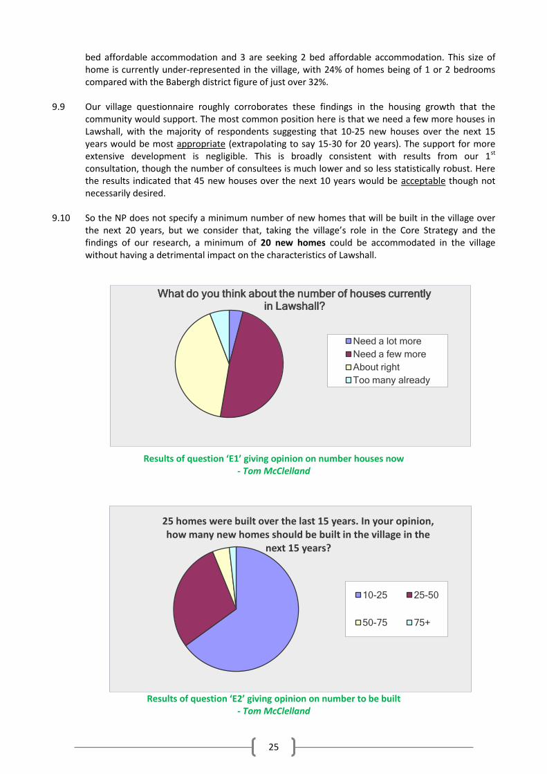
9.9 Our village questionnaire roughly corroborates these findings in the housing growth that the
community would support. The most common position here is that we need a few more houses in Lawshall, with the majority of respondents suggesting that 10-25 new houses over the next 15 years would be most appropriate (extrapolating to say 15-30 for 20 years). The support for more extensive development is negligible. This is broadly consistent with results from our 1st
consultation, though the number of consultees is much lower and so less statistically robust. Here the results indicated that 45 new houses over the next 10 years would be acceptable though not necessarily desired.
9.10 So the NP does not specify a minimum number of new homes that will be built in the village over
the next 20 years, but we consider that, taking the village’s role in the Core Strategy and the findings of our research, a minimum of 20 new homes could be accommodated in the village without having a detrimental impact on the characteristics of Lawshall.
Results of question ‘E1’ giving opinion on number houses now - Tom McClelland
Results of question ‘E2’ giving opinion on number to be built
- Tom McClelland
What do you think about the number of houses currently in Lawshall?
Need a lot more
Need a few more
About right
Too many already
25 homes were built over the last 15 years. In your opinion, how many new homes should be built in the village in the
next 15 years?
10-25 25-50
50-75 75+
26
Housing Distribution 9.11 As described in ‘Lawshall Present’ in Part One, the distribution of our housing takes the form of a
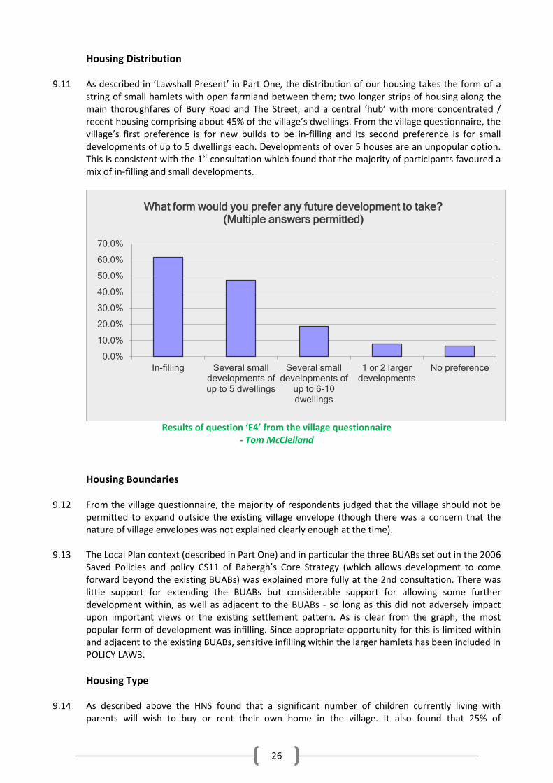
string of small hamlets with open farmland between them; two longer strips of housing along the main thoroughfares of Bury Road and The Street, and a central ‘hub’ with more concentrated / recent housing comprising about 45% of the village’s dwellings. From the village questionnaire, the village’s first preference is for new builds to be in-filling and its second preference is for small developments of up to 5 dwellings each. Developments of over 5 houses are an unpopular option. This is consistent with the 1st consultation which found that the majority of participants favoured a mix of in-filling and small developments.
Results of question ‘E4’ from the village questionnaire
- Tom McClelland
Housing Boundaries
9.12 From the village questionnaire, the majority of respondents judged that the village should not be
permitted to expand outside the existing village envelope (though there was a concern that the nature of village envelopes was not explained clearly enough at the time).
9.13 The Local Plan context (described in Part One) and in particular the three BUABs set out in the 2006
Saved Policies and policy CS11 of Babergh’s Core Strategy (which allows development to come forward beyond the existing BUABs) was explained more fully at the 2nd consultation. There was little support for extending the BUABs but considerable support for allowing some further development within, as well as adjacent to the BUABs - so long as this did not adversely impact upon important views or the existing settlement pattern. As is clear from the graph, the most popular form of development was infilling. Since appropriate opportunity for this is limited within and adjacent to the existing BUABs, sensitive infilling within the larger hamlets has been included in POLICY LAW3.
Housing Type 9.14 As described above the HNS found that a significant number of children currently living with
parents will wish to buy or rent their own home in the village. It also found that 25% of
0.0%
10.0%
20.0%
30.0%
40.0%
50.0%
60.0%
70.0%
In-filling Several small developments of up to 5 dwellings
Several small developments of
up to 6-10 dwellings
1 or 2 larger developments
No preference
What form would you prefer any future development to take? (Multiple answers permitted)
27
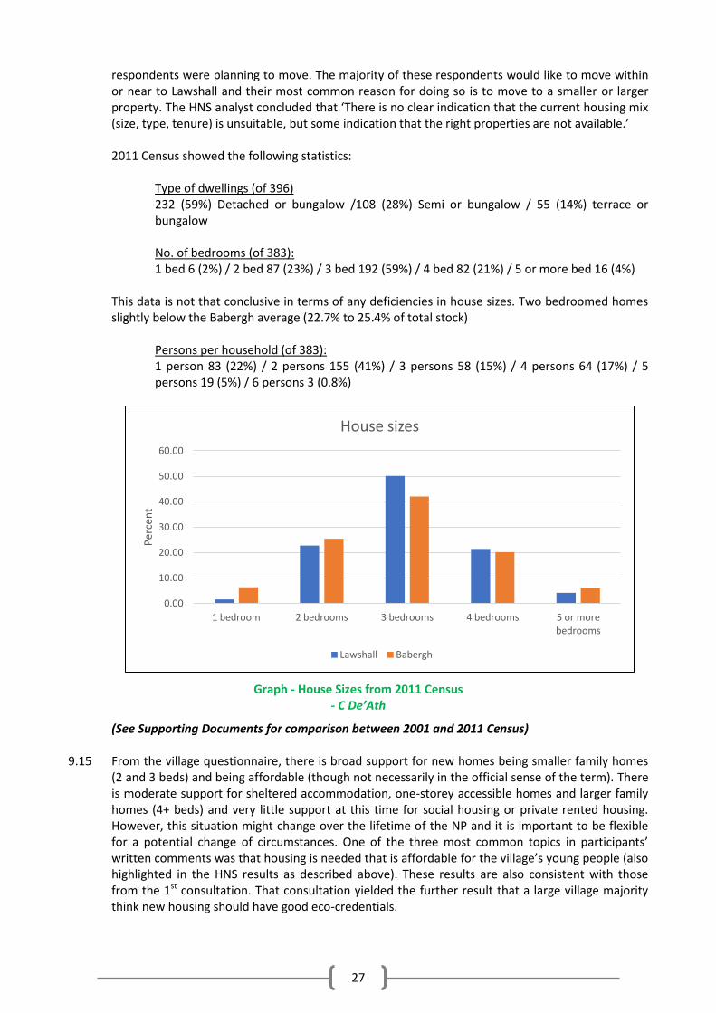
respondents were planning to move. The majority of these respondents would like to move within or near to Lawshall and their most common reason for doing so is to move to a smaller or larger property. The HNS analyst concluded that ‘There is no clear indication that the current housing mix (size, type, tenure) is unsuitable, but some indication that the right properties are not available.’ 2011 Census showed the following statistics:
Type of dwellings (of 396) 232 (59%) Detached or bungalow /108 (28%) Semi or bungalow / 55 (14%) terrace or bungalow
No. of bedrooms (of 383): 1 bed 6 (2%) / 2 bed 87 (23%) / 3 bed 192 (59%) / 4 bed 82 (21%) / 5 or more bed 16 (4%)
This data is not that conclusive in terms of any deficiencies in house sizes. Two bedroomed homes slightly below the Babergh average (22.7% to 25.4% of total stock)
Persons per household (of 383): 1 person 83 (22%) / 2 persons 155 (41%) / 3 persons 58 (15%) / 4 persons 64 (17%) / 5 persons 19 (5%) / 6 persons 3 (0.8%)
Graph - House Sizes from 2011 Census - C De’Ath
(See Supporting Documents for comparison between 2001 and 2011 Census) 9.15 From the village questionnaire, there is broad support for new homes being smaller family homes
(2 and 3 beds) and being affordable (though not necessarily in the official sense of the term). There is moderate support for sheltered accommodation, one-storey accessible homes and larger family homes (4+ beds) and very little support at this time for social housing or private rented housing. However, this situation might change over the lifetime of the NP and it is important to be flexible for a potential change of circumstances. One of the three most common topics in participants’ written comments was that housing is needed that is affordable for the village’s young people (also highlighted in the HNS results as described above). These results are also consistent with those from the 1st consultation. That consultation yielded the further result that a large village majority think new housing should have good eco-credentials.
0.00
10.00
20.00
30.00
40.00
50.00
60.00
1 bedroom 2 bedrooms 3 bedrooms 4 bedrooms 5 or more bedrooms
Per
cen
t
House sizes
Lawshall Babergh
28
9.16 The Core Strategy already contains a policy for the provision of affordable housing in villages on exception sites (see glossary for explanation). However, given the potential for a locally identified need for this housing, it is considered important that any such development should:
I. always remain affordable; II. be for people in housing need that are unable to buy or rent properties in the village at
open-market prices; and III. be offered, in the first instance, to people with a demonstrated local connection such as
through direct family connections or work. This should be achieved through a legal agreement attached to any planning consent. More guidance on local connections criteria is available on request from the Council’s Housing Team.
POLICY LAW2 – Housing Development within the Built-Up Area Boundaries
Within the Built-up Area Boundaries, as defined on the Proposals Map, there is a general presumption in favour of residential development in the form of single dwellings and small groups of up to five dwellings
The scale and nature of all schemes must ensure an appropriate level of services, facilities and infrastructure, including primary school capacity, are available or can be provided to serve the proposed development.
POLICY LAW3 – Housing Development outside the Built-Up Area Boundary
Proposals for new housing development outside the Built-Up Area Boundary will be permitted where they take the form of:
single dwellings and small groups of up to 5 dwellings outside, but adjacent to, the Built-up Area Boundary; or
one dwelling or a pair of semi-detached dwellings on an undeveloped plot adjacent to or fronting an existing highway and within a cluster identified in Policy LAW1.
The scale and nature of all schemes must ensure an appropriate level of services, facilities and infrastructure, including primary school capacity, are available or can be provided to serve the proposed development. All proposals should be accompanied by:
a completed CS11 assessment checklist, which takes into account any cumulative impact taken with other existing commitments in the village; and
a Landscape Visual Impact Assessment; Permission will not be granted where:
a proposal harms or undermines a Settlement Gap identified by Policy LAW9 or otherwise does not accord with that policy,
where development would have an adverse impact on the environment or highway safety; or
a proposal comprises ribbon development that would result in the coalescence of settlements and identified clusters.
Note: A small undeveloped plot is one which could be filled by one detached or a pair of semi-detached dwellings where the plot sizes and spacing between dwellings is similar to adjacent properties and thereby respects the rural character and street scene of the locality.
29
POLICY LAW4 – Housing Mix Housing development must contribute to meeting the existing and future needs of the Parish. Planning proposals will be supported where development provides a mix of housing types and sizes that reflects the needs of local people particularly in the need for 2 and 3 bedroom dwellings for first time buyers as well as the needs of an ageing population looking to downsize into homes suitable for lifetime occupation.
POLICY LAW5 – Affordable Housing on Rural Exception Sites In accordance with Policy CS20 of the Babergh Core Strategy, proposals for the development of small-scale affordable housing schemes on rural exception sites outside the Built-up Area Boundary, where housing would not normally be permitted by other policies, will be supported where there is a proven local need and provided that the housing:
i. always remains affordable; ii. is for people that are in housing need by virtue that they are unable to buy or rent
properties in the village at open-market prices; iii. is offered, in the first instance, to people with a demonstrated local connection. Where
there is no need, a property should then be offered to those with a demonstrated need for affordable housing in neighbouring villages.
These restrictions should be delivered through a legal agreement attached to the planning consent for the housing. Note: More guidance on local connections criteria is available in Babergh’s “Local Connection Criteria for Local Housing Needs Schemes”
30
10. OUR NATURAL ENVIRONMENT
Open Spaces (D Thomas, Hall Mead) 10.1 Lawshall is fortunate to have several accessible open spaces that are available for public use
and recreation, in addition to its village greens and community woodlands. The community woodlands are managed by local residents and provide recreation and education for the wider community as well as for village residents.
10.2 In the 1st consultation people were asked to identify the features they value most in the
parish. The "village landscape with its greens and open spaces" was the 3rd most valued feature, to which 80% of respondents "strongly agreed".
10.3 At the 2nd consultation people were given, more specifically, a list of the main open spaces,
and asked to identify their level of importance to the community. Seven open spaces were highlighted and all received a high number of votes for ‘very important’, a few for ‘quite important’ and only two for ‘not important’. These are listed in the order of most votes:
1) The Foundry Meadow – used for accredited Forest School training and outdoor courses for young people; also a haven for Bee and Pyramidal orchids
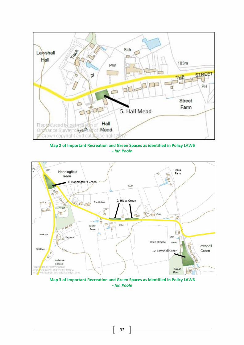
2) *The Glebe open space – central grassy landscaped area to our largest housing development; highly valued by the residents 3) *Walcher’s Meadow – recreation space between the enclaves of the central ‘hub’; includes a fenced play area, seating and walkways. 4) Village Hall open space – provides attractive green setting to highly valued amenity; used for sport by youth club etc.; also as outdoor extension to community events 5) *Hall Mead open space – grassy landscaped centre to small one-storey development opposite our Grade 1 listed church and site of our distinctive village sign 6) *Churchill Close Meadow – large grass area in middle of central ‘hub’; used for sport and highly valued by residents as rural backdrop to housing In addition, the following greens are also of significant importance in terms of their contribution to the provision of accessible open space in the village. 7) Harrow Green - narrow strip of green with Jubilee bench 8) Hanningfield Green - triangular green designated a County Wildlife Site with wide variety of flora and managed for conservation by residents 9) Hibbs Green – two narrow strips of green that provide an attractive wide verge 10) Lawshall Green – the largest green also with wide variety of flora and managed for conservation by residents
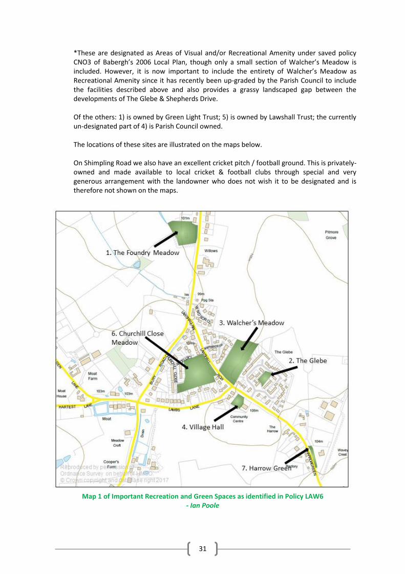
31
*These are designated as Areas of Visual and/or Recreational Amenity under saved policy CNO3 of Babergh’s 2006 Local Plan, though only a small section of Walcher’s Meadow is included. However, it is now important to include the entirety of Walcher’s Meadow as Recreational Amenity since it has recently been up-graded by the Parish Council to include the facilities described above and also provides a grassy landscaped gap between the developments of The Glebe & Shepherds Drive.
Of the others: 1) is owned by Green Light Trust; 5) is owned by Lawshall Trust; the currently un-designated part of 4) is Parish Council owned. The locations of these sites are illustrated on the maps below. On Shimpling Road we also have an excellent cricket pitch / football ground. This is privately-owned and made available to local cricket & football clubs through special and very generous arrangement with the landowner who does not wish it to be designated and is therefore not shown on the maps.
Map 1 of Important Recreation and Green Spaces as identified in Policy LAW6
- Ian Poole
32
Map 2 of Important Recreation and Green Spaces as identified in Policy LAW6
- Ian Poole
Map 3 of Important Recreation and Green Spaces as identified in Policy LAW6
- Ian Poole
33
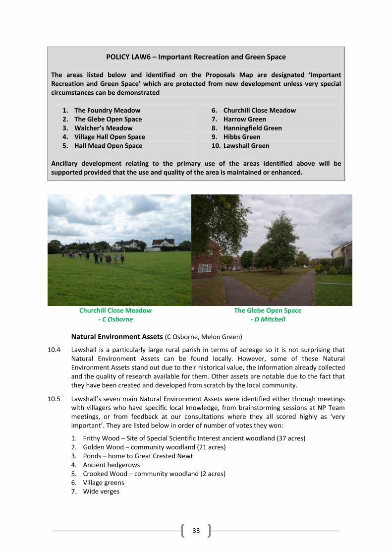
POLICY LAW6 – Important Recreation and Green Space The areas listed below and identified on the Proposals Map are designated ‘Important Recreation and Green Space’ which are protected from new development unless very special circumstances can be demonstrated
1. The Foundry Meadow 2. The Glebe Open Space 3. Walcher’s Meadow 4. Village Hall Open Space 5. Hall Mead Open Space
6. Churchill Close Meadow 7. Harrow Green 8. Hanningfield Green 9. Hibbs Green 10. Lawshall Green
Ancillary development relating to the primary use of the areas identified above will be supported provided that the use and quality of the area is maintained or enhanced.
Churchill Close Meadow
- C Osborne
The Glebe Open Space
- D Mitchell
Natural Environment Assets (C Osborne, Melon Green)
10.4 Lawshall is a particularly large rural parish in terms of acreage so it is not surprising that Natural Environment Assets can be found locally. However, some of these Natural Environment Assets stand out due to their historical value, the information already collected and the quality of research available for them. Other assets are notable due to the fact that they have been created and developed from scratch by the local community.
10.5 Lawshall’s seven main Natural Environment Assets were identified either through meetings with villagers who have specific local knowledge, from brainstorming sessions at NP Team meetings, or from feedback at our consultations where they all scored highly as ‘very important’. They are listed below in order of number of votes they won:
1. Frithy Wood – Site of Special Scientific Interest ancient woodland (37 acres) 2. Golden Wood – community woodland (21 acres) 3. Ponds – home to Great Crested Newt 4. Ancient hedgerows 5. Crooked Wood – community woodland (2 acres) 6. Village greens 7. Wide verges
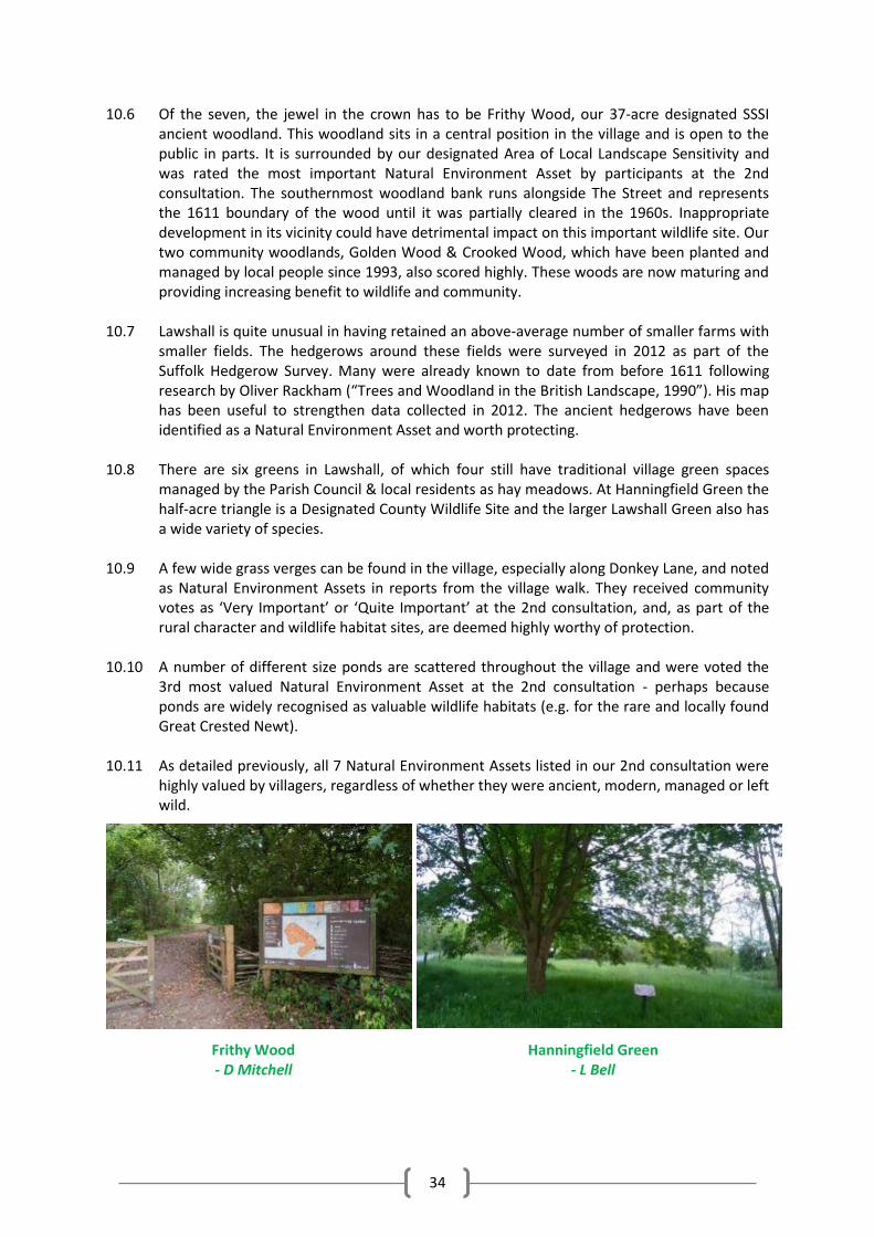
34
10.6 Of the seven, the jewel in the crown has to be Frithy Wood, our 37-acre designated SSSI ancient woodland. This woodland sits in a central position in the village and is open to the public in parts. It is surrounded by our designated Area of Local Landscape Sensitivity and was rated the most important Natural Environment Asset by participants at the 2nd consultation. The southernmost woodland bank runs alongside The Street and represents the 1611 boundary of the wood until it was partially cleared in the 1960s. Inappropriate development in its vicinity could have detrimental impact on this important wildlife site. Our two community woodlands, Golden Wood & Crooked Wood, which have been planted and managed by local people since 1993, also scored highly. These woods are now maturing and providing increasing benefit to wildlife and community.
10.7 Lawshall is quite unusual in having retained an above-average number of smaller farms with
smaller fields. The hedgerows around these fields were surveyed in 2012 as part of the Suffolk Hedgerow Survey. Many were already known to date from before 1611 following research by Oliver Rackham (“Trees and Woodland in the British Landscape, 1990”). His map has been useful to strengthen data collected in 2012. The ancient hedgerows have been identified as a Natural Environment Asset and worth protecting.
10.8 There are six greens in Lawshall, of which four still have traditional village green spaces
managed by the Parish Council & local residents as hay meadows. At Hanningfield Green the half-acre triangle is a Designated County Wildlife Site and the larger Lawshall Green also has a wide variety of species.
10.9 A few wide grass verges can be found in the village, especially along Donkey Lane, and noted
as Natural Environment Assets in reports from the village walk. They received community votes as ‘Very Important’ or ‘Quite Important’ at the 2nd consultation, and, as part of the rural character and wildlife habitat sites, are deemed highly worthy of protection.
10.10 A number of different size ponds are scattered throughout the village and were voted the
3rd most valued Natural Environment Asset at the 2nd consultation - perhaps because ponds are widely recognised as valuable wildlife habitats (e.g. for the rare and locally found Great Crested Newt).
10.11 As detailed previously, all 7 Natural Environment Assets listed in our 2nd consultation were
highly valued by villagers, regardless of whether they were ancient, modern, managed or left wild.
Frithy Wood - D Mitchell
Hanningfield Green - L Bell
35
Biodiversity (C Osborne, Melon Green)
10.12 The Government’s Biodiversity Action Plan sets challenging targets to preserve and increase the UKs fast diminishing biodiversity. When the County Council’s then BAP officer visited Lawshall in 2010, she commended Golden Wood very highly for its contribution to increasing biodiversity. Lawshall’s extensive network of Natural Environment Assets provide the perfect habitat for some of the UK’s rare and declining species and there is a strong commitment to habitat preservation and creation throughout the village. Green Light Trust, an environmental education charity based in the village, is restoring part of Lawshall’s SSSI woodland, Frithy Wood; a village steering group, manages Forest for Our Children (our two community woodlands); community volunteers manage a County Wildlife Site; there are a host of smaller private sites managed specifically for wildlife. In addition, a number of local residents record and monitor species, so the data sets available for Lawshall are valuable.
10.13 In Frithy Wood several rare species have been recorded including the White-letter Hairstreak, a red list butterfly and the Barbastelle bat. Nesting bird surveys have been regularly carried out in both Frithy Wood and Golden Wood to build a clear picture of the health and value of the woods to common bird species. 15 red list birds have been recorded in and around Golden Wood and all those depicted in The Golden Wood Painting have already been recorded bar one, despite the wood having been agricultural land until 1994.
10.14 Lawshall has a diverse range of flora. Most notable species include Adder’s Tongue Fern and 4 notable varieties of orchid. Woodland species include Nettle-leaved Bellflower, Herb Paris, Oxlip and extensive carpets of Wood Anemone. The first group of these thrive on managed grassland and are sensitive to being swamped by uncut grass or compacted ground. The second group are dependent on traditional woodland management and their habitat remaining intact. (See Appendix 2 for examples of wildlife surveys)
POLICY LAW7 - Protecting Existing Natural Environmental Assets
Important woodland and ancient hedgerows, shown on the Proposals Map, are valued highly by the community and are to be protected. Any development proposals which impacts upon them should contribute to, rather than detract from, their biodiversity value.
POLICY LAW8 – Protecting and Maintaining Features of Biodiversity Value
All development proposals will be expected to retain existing features of biodiversity value (including ponds, trees, hedgerows) and, where practical to do so, provide a net gain in biodiversity through, for example:
The creation of new natural habitats;
The planting of additional trees and hedgerows (reflecting the character of Lawshall’s traditional hedgerows); and
Restoring and repairing fragmented biodiversity networks.
Where loss or damage is unavoidable, the benefits of the development proposals must be demonstrated clearly to outweigh any impacts and the development shall provide for appropriate replacement planting on site together with a method statement for the ongoing care and maintenance of that planting.
Where a new access is created, or an existing access is widened through an existing hedgerow, a new hedgerow of native species shall be planted on the splay returns into the site to maintain the appearance and continuity of hedgerows in the vicinity.
36
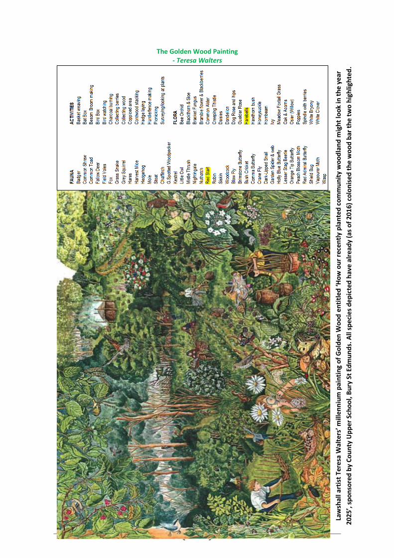
The Golden Wood Painting - Teresa Walters
Law
shal
l art
ist
Ter
esa
Wal
ters
’ mill
enn
ium
pai
nti
ng
of
Go
lde
n W
oo
d e
nti
tle
d ‘H
ow
ou
r re
cen
tly
pla
nte
d c
om
mu
nit
y w
oo
dla
nd
mig
ht
loo
k in
th
e ye
ar
202
5’, s
po
nso
red
by
Co
un
ty U
pp
er S
cho
ol,
Bu
ry S
t Ed
mu
nd
s. A
ll sp
eci
es
dep
icte
d h
ave
alr
ead
y (a
s o
f 2
01
6)
colo
nis
ed t
he
wo
od
bar
th
e tw
o h
igh
ligh
ted
.
37
Public Views (Walk & Character Group)
10.15 With Lawshall’s layout as a string of hamlets across a stretch of High Suffolk, it’s not surprising that we have many far-reaching views. Seen from our roads and lanes they take the eye over traditional landscapes of fields and woods – often towards our neighbouring villages of Hartest, Shimpling, Cockfield and Lavenham.
10.16 On our NP Village Walk many favourite views were identified and photographed as detailed
in our Character Assessment. Then at our 2nd consultation people were asked to choose their top 5 Views from a list of 12. Most of these Views scored high marks and Views were also ‘highly valued’ at our 1st consultation while a large majority of Questionnaire respondents ‘strongly agreed’ that they should be protected
*The Suffolk Landscape Character Assessment identifies Lawshall as: ‘part of a landscape character area of Undulating Ancient Farmlands of which there is little remaining’. It is on this ancient farmland that Lawshall’s hamlets sprang up, originally, it is believed, as tiny settlements for the shepherding of early flocks of sheep and then for the workers on the many village farms. And it is between these hamlets, still intact, that today’s views abound.
10.17 As a treasured feature of Lawshall’s distinctive character, we wish to designate them as
Settlement Gaps and believe we have a strong mandate for this, both from our residents and for historical reasons.
10.18 The saved policies of the 2006 Babergh Local Plan include Policy CN03 which protects
important open space, visually important gaps in the street scene and recreational facilities within villages. Lawshall’s distinct character of a number of small settlements separated by open countryside has, during community engagement, been identified as a feature that residents especially wish to preserve. Accordingly, within the context of the saved Local Plan policy, a number of gaps between settlements have been identified of being of such importance that it is considered they should be preserved from all but essential development that cannot be located elsewhere.
View from Harrow Green - D Page
View from Donkey Lane - D Mitchell
38
POLICY LAW9 - Settlement Gaps The generally open and undeveloped nature of the gaps separating the distinct settlements in the village, as identified on the Proposals Map, will be protected from development in order to preserve the visual qualities of the landscape and to prevent coalescence and retain the separate identity of the settlements. Development will only be permitted within the identified gap if:
i. it would not undermine the physical and/or visual separation of the settlements; and ii. it would not compromise the integrity of the Settlement Gap, either individually or in
combination with other existing or proposed development; and iii. identified important views will be protected.
Lawshall Area of Local Landscape Sensitivity
10.19 A Special Landscape Area near and including Frithy Wood has been designated in the
development plan for a number of years. It extends north to join up with the Special Landscape Area recently reaffirmed in the St Edmundsbury Local Plan. It also borders on to one of the most iconic views that looks out from Donkey Lane across a wide dip of open fields towards Lavenham. Residents of Lawshall have demonstrated support to retain this designation which is reaffirmed in Policy LAW10 - Area of Local Landscape Sensitivity, below.
POLICY LAW10 - Area of Local Landscape Sensitivity Development proposals in the Lawshall Area of Local Landscape Sensitivity, as identified on the Proposals Map, will be permitted only where they: • protect or enhance the special landscape qualities of the area, identified in the Landscape
Character Assessment; and • are designed and sited so as to harmonise with the landscape setting.
39
11. OUR BUILT HERITAGE & DESIGN 11.1 Lawshall has an impressive portfolio of both listed buildings and other buildings that are
locally distinctive. Many are built using traditional and locally sourced materials and display prominent details / features which reflect the era they were built in. Over time, these 'details' and ‘features’ have played an important part in forming Lawshall's 'character' (as described in our Character Assessment). However, there is no designated Conservation Area to protect areas of special architectural or historic interest.
11.2 Both our listed buildings and other buildings of note are scattered across the parish, with
many gracing our hamlets or perched on our country lanes, while others lie in the BUABs on Bury Road and The Street. At our 2nd consultation the desire and need to protect our built heritage scored highly.
Listed Buildings (Archive Group) 11.3 Lawshall has 1 Grade 1 listed building (All Saints Church), 1 Grade 2* listed building,
(Lawshall Hall) and 25 Grade 2 listed buildings fairly evenly dotted around the parish as described above.
11.4 The famous Tudor Lawshall Hall (see Lawshall Past in Part One), has only 1 wing remaining
today and, after years of standing vacant, is currently being painstakingly renovated. Also of particular interest and possibly the oldest, is Keepers Cottage (1400s), with indication still apparent that it was originally a medieval ‘open hall’ house.
11.5 We also have 1 scheduled Moated site close to New House Farm, Shimpling Road (and one
unscheduled moat at Moat House, Hartest Lane + an incomplete moat at Bayleaf House). 11.6 Concern and desire for the protection of these heritage heirlooms was strongly expressed in
all our major consultations. (See Appendix 3 for full list of Listed Buildings)
Keepers Cottage - Village Archive
40
Lawshall Hall - Village Archive
Unlisted Buildings of Note (Archive group & P Harber) 11.7 Our village Archive Group & local timber frame specialist have identified 33 unlisted
buildings and structures of note. These all have histories and/or features considered highly worthy of protection. Through community consultation, residents stated that they were keen to recognise the important contribution that these buildings make to the built environment.
11.8 Of particular interest is Bay Leaf House circa 1420; older villagers can remember visiting it
when it was Lawshall General Stores. Two non-residential buildings of note are:
1) The Foundry, Green Light Trust’s RIBA award-winning headquarters; this carbon-neutral restoration of a 19th century farm building was once used to repair agricultural steam machinery as typified by the sketch of the early Ransomes’ Portable Steam Engine in Part One.
2) Drake’s Well, dedicated to naturalist and explorer, Charles Frederick Drake (1846 – 1874), and now a favourite resting spot for the walkers on the St Edmund Way.
11.9 At our 2nd consultation the large majority of consultees that responded to the question
about these buildings of note, marked their protection as ‘Very important’. With this in mind, the creation of a local list of heritage assets would recognise the important contribution that these buildings make to the character of the village. A local heritage asset is not already statutorily listed, but is of significant architectural interest within Lawshall. An asset may be included on the list for its architectural qualities alone, or because it has additional historical or social interest. Assets may be important in the social, political, industrial, economic or architectural history of Lawshall or have a strong connection with a notable person.
11.10 Although this NP does not propose a list of local heritage assets, it is considered important
to reflect the views of residents and instigate the preparation of a ‘local list’. The criteria for choosing the ‘local list’, as agreed with our timber frame specialist, are described in Appendix 4. The initiative will continue to be explored through the NP Team working with the Heritage Team at Babergh District Council with a view to the District Council establishing a local list for Lawshall. (See Appendix 4 for more on Lawshall’s Buildings & Structures of Note)
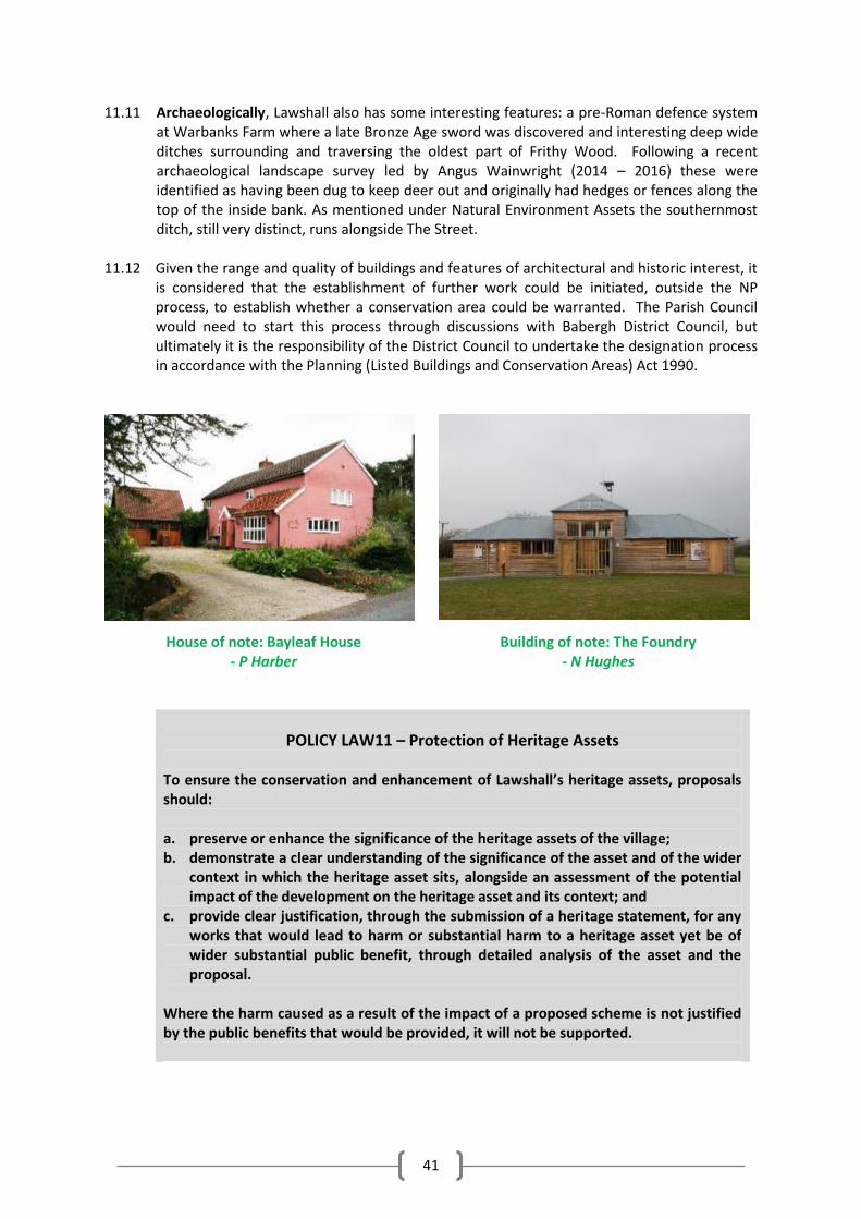
41
11.11 Archaeologically, Lawshall also has some interesting features: a pre-Roman defence system at Warbanks Farm where a late Bronze Age sword was discovered and interesting deep wide ditches surrounding and traversing the oldest part of Frithy Wood. Following a recent archaeological landscape survey led by Angus Wainwright (2014 – 2016) these were identified as having been dug to keep deer out and originally had hedges or fences along the top of the inside bank. As mentioned under Natural Environment Assets the southernmost ditch, still very distinct, runs alongside The Street.
11.12 Given the range and quality of buildings and features of architectural and historic interest, it
is considered that the establishment of further work could be initiated, outside the NP process, to establish whether a conservation area could be warranted. The Parish Council would need to start this process through discussions with Babergh District Council, but ultimately it is the responsibility of the District Council to undertake the designation process in accordance with the Planning (Listed Buildings and Conservation Areas) Act 1990.
House of note: Bayleaf House - P Harber
Building of note: The Foundry - N Hughes
POLICY LAW11 – Protection of Heritage Assets To ensure the conservation and enhancement of Lawshall’s heritage assets, proposals should: a. preserve or enhance the significance of the heritage assets of the village; b. demonstrate a clear understanding of the significance of the asset and of the wider
context in which the heritage asset sits, alongside an assessment of the potential impact of the development on the heritage asset and its context; and
c. provide clear justification, through the submission of a heritage statement, for any works that would lead to harm or substantial harm to a heritage asset yet be of wider substantial public benefit, through detailed analysis of the asset and the proposal.
Where the harm caused as a result of the impact of a proposed scheme is not justified by the public benefits that would be provided, it will not be supported.
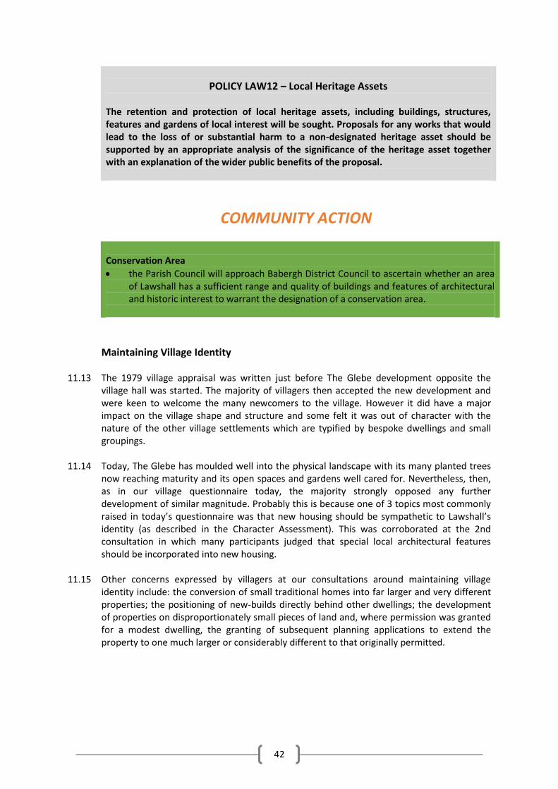
42
POLICY LAW12 – Local Heritage Assets The retention and protection of local heritage assets, including buildings, structures, features and gardens of local interest will be sought. Proposals for any works that would lead to the loss of or substantial harm to a non-designated heritage asset should be supported by an appropriate analysis of the significance of the heritage asset together with an explanation of the wider public benefits of the proposal.
COMMUNITY ACTION Conservation Area
the Parish Council will approach Babergh District Council to ascertain whether an area of Lawshall has a sufficient range and quality of buildings and features of architectural and historic interest to warrant the designation of a conservation area.
Maintaining Village Identity
11.13 The 1979 village appraisal was written just before The Glebe development opposite the
village hall was started. The majority of villagers then accepted the new development and were keen to welcome the many newcomers to the village. However it did have a major impact on the village shape and structure and some felt it was out of character with the nature of the other village settlements which are typified by bespoke dwellings and small groupings.
11.14 Today, The Glebe has moulded well into the physical landscape with its many planted trees
now reaching maturity and its open spaces and gardens well cared for. Nevertheless, then, as in our village questionnaire today, the majority strongly opposed any further development of similar magnitude. Probably this is because one of 3 topics most commonly raised in today’s questionnaire was that new housing should be sympathetic to Lawshall’s identity (as described in the Character Assessment). This was corroborated at the 2nd consultation in which many participants judged that special local architectural features should be incorporated into new housing.
11.15 Other concerns expressed by villagers at our consultations around maintaining village
identity include: the conversion of small traditional homes into far larger and very different properties; the positioning of new-builds directly behind other dwellings; the development of properties on disproportionately small pieces of land and, where permission was granted for a modest dwelling, the granting of subsequent planning applications to extend the property to one much larger or considerably different to that originally permitted.
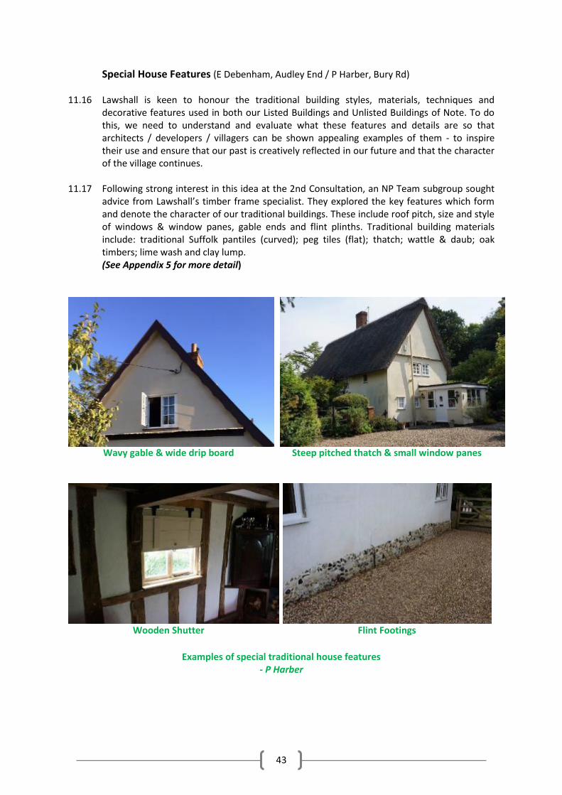
43
Special House Features (E Debenham, Audley End / P Harber, Bury Rd) 11.16 Lawshall is keen to honour the traditional building styles, materials, techniques and
decorative features used in both our Listed Buildings and Unlisted Buildings of Note. To do this, we need to understand and evaluate what these features and details are so that architects / developers / villagers can be shown appealing examples of them - to inspire their use and ensure that our past is creatively reflected in our future and that the character of the village continues.
11.17 Following strong interest in this idea at the 2nd Consultation, an NP Team subgroup sought
advice from Lawshall’s timber frame specialist. They explored the key features which form and denote the character of our traditional buildings. These include roof pitch, size and style of windows & window panes, gable ends and flint plinths. Traditional building materials include: traditional Suffolk pantiles (curved); peg tiles (flat); thatch; wattle & daub; oak timbers; lime wash and clay lump. (See Appendix 5 for more detail)
Wavy gable & wide drip board Steep pitched thatch & small window panes
Wooden Shutter Flint Footings
Examples of special traditional house features
- P Harber
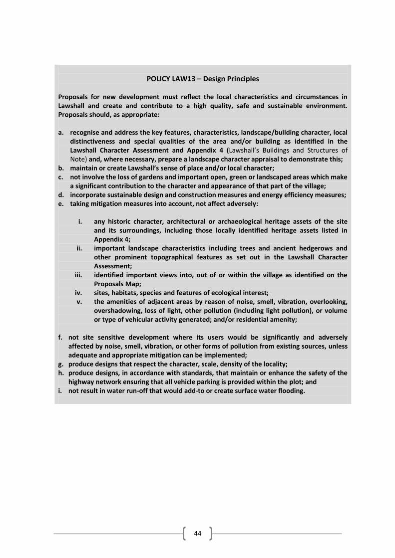
44
POLICY LAW13 – Design Principles Proposals for new development must reflect the local characteristics and circumstances in Lawshall and create and contribute to a high quality, safe and sustainable environment. Proposals should, as appropriate: a. recognise and address the key features, characteristics, landscape/building character, local
distinctiveness and special qualities of the area and/or building as identified in the Lawshall Character Assessment and Appendix 4 (Lawshall’s Buildings and Structures of Note) and, where necessary, prepare a landscape character appraisal to demonstrate this;
b. maintain or create Lawshall’s sense of place and/or local character; c. not involve the loss of gardens and important open, green or landscaped areas which make
a significant contribution to the character and appearance of that part of the village; d. incorporate sustainable design and construction measures and energy efficiency measures; e. taking mitigation measures into account, not affect adversely:
i. any historic character, architectural or archaeological heritage assets of the site
and its surroundings, including those locally identified heritage assets listed in Appendix 4;
ii. important landscape characteristics including trees and ancient hedgerows and other prominent topographical features as set out in the Lawshall Character Assessment;
iii. identified important views into, out of or within the village as identified on the Proposals Map;
iv. sites, habitats, species and features of ecological interest; v. the amenities of adjacent areas by reason of noise, smell, vibration, overlooking,
overshadowing, loss of light, other pollution (including light pollution), or volume or type of vehicular activity generated; and/or residential amenity;
f. not site sensitive development where its users would be significantly and adversely
affected by noise, smell, vibration, or other forms of pollution from existing sources, unless adequate and appropriate mitigation can be implemented;
g. produce designs that respect the character, scale, density of the locality; h. produce designs, in accordance with standards, that maintain or enhance the safety of the
highway network ensuring that all vehicle parking is provided within the plot; and i. not result in water run-off that would add-to or create surface water flooding.
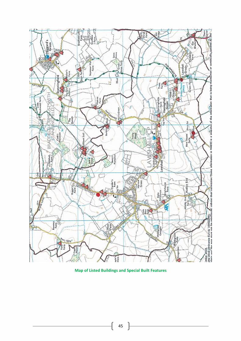
45
Map of Listed Buildings and Special Built Features
46
12. OUR AMENITIES & SERVICES (D Page, Harrow Green)
12.1 In producing the NP we wanted to know what the village valued in terms of amenities as well as understand what improvements are thought to be needed. Lawshall’s current amenities include All Saints CEVCP Primary School, The Swan public house and Lawshall Village Hall. Until June 2016 we also had a much-used village shop which closed and has now been designated a community asset by our Parish Council. There are three places of religious worship: All Saints Church, Church of Our Lady Immaculate & St. Joseph and Lawshall Evangelical Free Church. Recently the Parish Council purchased Walcher’s Meadow as a community area including a children’s play area. There is also a cricket / football pitch on ground privately owned on Shimpling Road and another open space used for sport behind Churchill Close. Lawshall is served by a limited bus service. Our Mobile Library persists and one of our telephone boxes has been transformed through local initiative into a book swap shop and information point. There is currently no doctor’s surgery in the village and people have to travel to obtain health services. Whilst the constraints on the NHS budgets are recognised, we will support National Health Services England in ensuring suitable and sustainable provision of Primary Healthcare services for our residents.
12.2 At our 1st consultation, participants were invited to specify the quality of the listed amenities
/ services as good, adequate or poor. They also had the opportunity to add more amenities to the list. At the same event, participants were asked what they valued most about the village by placing post-it notes on a board. From this we produced a table displaying the most popular responses. The process was repeated for the question “things for improvement”. From this initial consultation, we were able to ask pertinent questions on amenities / services in our more comprehensive village questionnaire.
12.3 The joint data from both events identify key emerging themes. The biggest response
highlighted the importance of the village shop and much distress at its closure (not due to lack of success) plus some weight of opinion for further shops such as a cafe, post office, hairdressers or butcher. The majority of respondents consider the village hall to be a valuable asset, true also for the school and village pub which also scored very highly as valued assets to the village (though the village hall is currently under-used and if residents don’t use it more there is a very real danger that we will lose it along with the shop). There was a strong consensus that public transport was very poor / in need of improvement (as was the case in the Village Appraisals of 1979 & ‘91!). Also a sorry shortage of footpaths and bridleways. And sports facilities and play areas have also been identified as in need of expansion/improvement - as highlighted by our school project ‘Child’s Eye View of Lawshall’. Finally, the hot topic of street lighting brought many votes and comments for and against. Even for limited lighting in key places there was a slim majority against. Thus at the time of writing this Plan there is no clear direction on the provision of street lighting. (See Footnote below for the figures from the village questionnaire).3
12.4 Where POLICIES around Amenities are not viable, the NP identifies ACTIONS to be taken to address majority concerns.
3 On the proposal that the village have general street lighting: 10 Strongly Agree / 13 Agree (total: 23); 96
Disagree / 155 Strongly Disagree (total: 251). On the proposal that the village have street lighting in a few key spots: 21 Strongly Agree / 101 Agree (total: 122); 75 Disagree / 72 Strongly Disagree (total: 147).
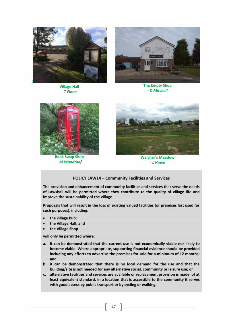
47
]
Village Hall - T Elmer
The Empty Shop
- D Mitchell
Book Swap Shop
- M Woodroof
Walcher’s Meadow
- L Howe
POLICY LAW14 – Community Facilities and Services
The provision and enhancement of community facilities and services that serve the needs of Lawshall will be permitted where they contribute to the quality of village life and improve the sustainability of the village.
Proposals that will result in the loss of existing valued facilities (or premises last used for such purposes), including:
the village Pub;
the Village Hall; and
the Village Shop
will only be permitted where:
a. it can be demonstrated that the current use is not economically viable nor likely to become viable. Where appropriate, supporting financial evidence should be provided including any efforts to advertise the premises for sale for a minimum of 12 months; and
b. it can be demonstrated that there is no local demand for the use and that the building/site is not needed for any alternative social, community or leisure use; or
c. alternative facilities and services are available or replacement provision is made, of at least equivalent standard, in a location that is accessible to the community it serves with good access by public transport or by cycling or walking.
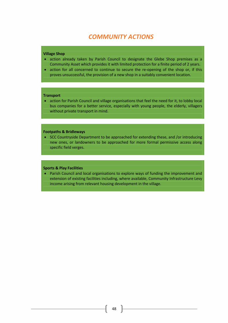
48
COMMUNITY ACTIONS Village Shop
action already taken by Parish Council to designate the Glebe Shop premises as a Community Asset which provides it with limited protection for a finite period of 2 years.
action for all concerned to continue to secure the re-opening of the shop or, if this proves unsuccessful, the provision of a new shop in a suitably convenient location.
Transport
action for Parish Council and village organisations that feel the need for it, to lobby local bus companies for a better service, especially with young people, the elderly, villagers without private transport in mind.
Footpaths & Bridleways
SCC Countryside Department to be approached for extending these, and /or introducing new ones, or landowners to be approached for more formal permissive access along specific field verges.
Sports & Play Facilities
Parish Council and local organisations to explore ways of funding the improvement and extension of existing facilities including, where available, Community Infrastructure Levy income arising from relevant housing development in the village.
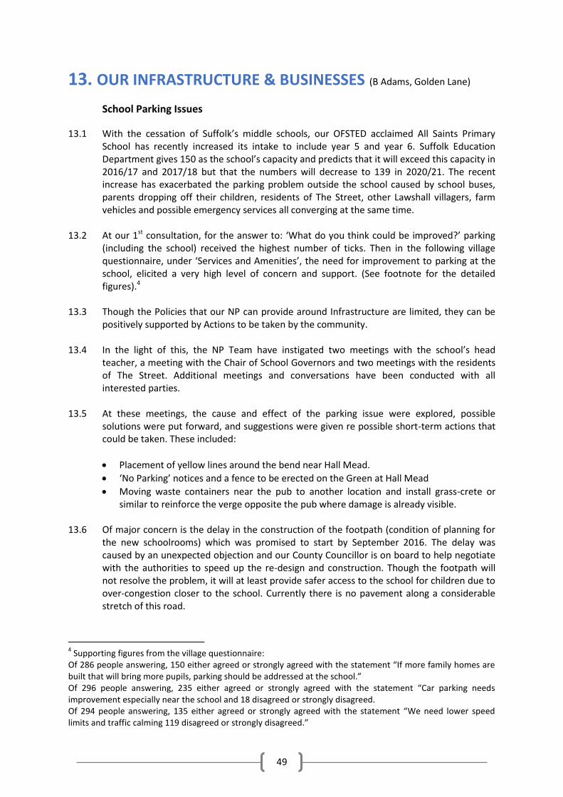
49
13. OUR INFRASTRUCTURE & BUSINESSES (B Adams, Golden Lane)
School Parking Issues
13.1 With the cessation of Suffolk’s middle schools, our OFSTED acclaimed All Saints Primary School has recently increased its intake to include year 5 and year 6. Suffolk Education Department gives 150 as the school’s capacity and predicts that it will exceed this capacity in 2016/17 and 2017/18 but that the numbers will decrease to 139 in 2020/21. The recent increase has exacerbated the parking problem outside the school caused by school buses, parents dropping off their children, residents of The Street, other Lawshall villagers, farm vehicles and possible emergency services all converging at the same time.
13.2 At our 1st consultation, for the answer to: ‘What do you think could be improved?’ parking
(including the school) received the highest number of ticks. Then in the following village questionnaire, under ‘Services and Amenities’, the need for improvement to parking at the school, elicited a very high level of concern and support. (See footnote for the detailed figures).4
13.3 Though the Policies that our NP can provide around Infrastructure are limited, they can be
positively supported by Actions to be taken by the community. 13.4 In the light of this, the NP Team have instigated two meetings with the school’s head
teacher, a meeting with the Chair of School Governors and two meetings with the residents of The Street. Additional meetings and conversations have been conducted with all interested parties.
13.5 At these meetings, the cause and effect of the parking issue were explored, possible
solutions were put forward, and suggestions were given re possible short-term actions that could be taken. These included:
Placement of yellow lines around the bend near Hall Mead.
‘No Parking’ notices and a fence to be erected on the Green at Hall Mead
Moving waste containers near the pub to another location and install grass-crete or similar to reinforce the verge opposite the pub where damage is already visible.
13.6 Of major concern is the delay in the construction of the footpath (condition of planning for
the new schoolrooms) which was promised to start by September 2016. The delay was caused by an unexpected objection and our County Councillor is on board to help negotiate with the authorities to speed up the re-design and construction. Though the footpath will not resolve the problem, it will at least provide safer access to the school for children due to over-congestion closer to the school. Currently there is no pavement along a considerable stretch of this road.
4 Supporting figures from the village questionnaire:
Of 286 people answering, 150 either agreed or strongly agreed with the statement “If more family homes are built that will bring more pupils, parking should be addressed at the school.” Of 296 people answering, 235 either agreed or strongly agreed with the statement “Car parking needs improvement especially near the school and 18 disagreed or strongly disagreed. Of 294 people answering, 135 either agreed or strongly agreed with the statement “We need lower speed limits and traffic calming 119 disagreed or strongly disagreed.”
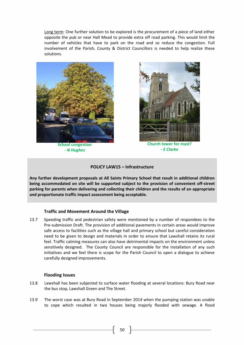
50
Long term: One further solution to be explored is the procurement of a piece of land either opposite the pub or near Hall Mead to provide extra off road parking. This would limit the number of vehicles that have to park on the road and so reduce the congestion. Full involvement of the Parish, County & District Councillors is needed to help realize these solutions.
School congestion
- N Hughes
Church tower for mast?
- E Clarke
POLICY LAW15 – Infrastructure Any further development proposals at All Saints Primary School that result in additional children being accommodated on site will be supported subject to the provision of convenient off-street parking for parents when delivering and collecting their children and the results of an appropriate and proportionate traffic impact assessment being acceptable.
Traffic and Movement Around the Village
13.7 Speeding traffic and pedestrian safety were mentioned by a number of respondees to the Pre-submission Draft. The provision of additional pavements in certain areas would improve safe access to facilities such as the village hall and primary school but careful consideration need to be given to design and materials in order to ensure that Lawshall retains its rural feel. Traffic calming measures can also have detrimental impacts on the environment unless sensitively designed. The County Council are responsible for the installation of any such initiatives and we feel there is scope for the Parish Council to open a dialogue to achieve carefully designed improvements.
Flooding Issues
13.8 Lawshall has been subjected to surface water flooding at several locations: Bury Road near the bus stop, Lawshall Green and The Street.
13.9 The worst case was at Bury Road in September 2014 when the pumping station was unable
to cope which resulted in two houses being majorly flooded with sewage. A flood
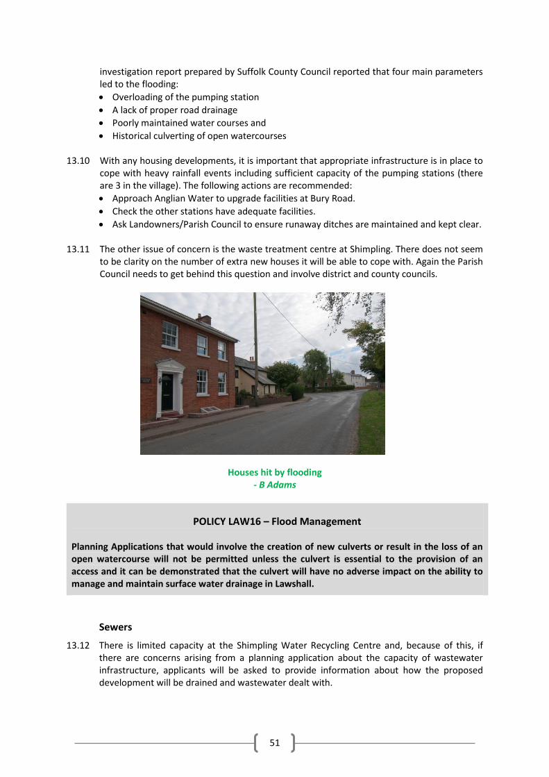
51
investigation report prepared by Suffolk County Council reported that four main parameters led to the flooding:
Overloading of the pumping station
A lack of proper road drainage
Poorly maintained water courses and
Historical culverting of open watercourses
13.10 With any housing developments, it is important that appropriate infrastructure is in place to cope with heavy rainfall events including sufficient capacity of the pumping stations (there are 3 in the village). The following actions are recommended:
Approach Anglian Water to upgrade facilities at Bury Road.
Check the other stations have adequate facilities.
Ask Landowners/Parish Council to ensure runaway ditches are maintained and kept clear. 13.11 The other issue of concern is the waste treatment centre at Shimpling. There does not seem
to be clarity on the number of extra new houses it will be able to cope with. Again the Parish Council needs to get behind this question and involve district and county councils.
Houses hit by flooding - B Adams
POLICY LAW16 – Flood Management Planning Applications that would involve the creation of new culverts or result in the loss of an open watercourse will not be permitted unless the culvert is essential to the provision of an access and it can be demonstrated that the culvert will have no adverse impact on the ability to manage and maintain surface water drainage in Lawshall.
Sewers
13.12 There is limited capacity at the Shimpling Water Recycling Centre and, because of this, if there are concerns arising from a planning application about the capacity of wastewater infrastructure, applicants will be asked to provide information about how the proposed development will be drained and wastewater dealt with.
52
Communications
13.13 There was a general dissatisfaction with telephone and broadband services in the village. This was identified in the village questionnaire. (See Footnote for figures)5 The options for overcoming these problems are through the improvement of cable and/or masts for improving connectivity. In terms of telephony, improved signal reception is essential which could require provision of a mast. These can be unsightly and their locations are not generally popular.5
13.14 Logically any mast installed needs to be at the highest point of the village. Thus, the tower of
All Saints Church, our grade 1 listed building, has been suggested and it may be possible to site a mast within the tower that will not harm the significance of this highly valued heritage treasure. The matter has been taken up with the PCC and the church authorities who raised no objection. We need to find a provider who is committed to installing this facility.
COMMUNITY ACTIONS
Parking at School As a matter of urgency all concerned parties to continue to work together to seek to resolve the current parking problems at All Saints Primary School during drop-off and pick-up periods.
Traffic and Movement Around the Village Parish Council to seek to work with the County Council to increase the pavement links in the village and install sensitively designed traffic calming measures in consultation with residents.
Flooding Risk Approach Anglian Water to upgrade facilities on Bury Road
Check that the other 2 pumping stations in the village have adequate facilities
Ask landowners / Parish Council to ensure existing ditches are maintained and kept clear
Improving telephone and broadband services Encourage the PCC to continue their search for a provider to place a mast on or within the church tower or, if this proves unsuccessful, to ask the Parish Council to investigate other options.
5 Of 292 people answering, 141 agreed or strongly agreed with the statement that they would be more likely
to work from home if their broadband connection was improved and 54 either disagreed or strongly disagreed. Of 296 people answering, 263 agreed or strongly agreed with the statement that our mobile phone networks need to be improved, and 13 either disagreed or strongly disagreed.
53
Business and Enterprise 13.15 We hope that better communications will encourage more villagers to be able to work from
home as well as encouraging more village-scale businesses and enterprises. Though the responses in the questionnaire to the statement: ‘Lawshall needs more small businesses’ were almost exactly 50:50 for and against, the summation of the additional comments showed that though we do need to encourage business and employment within the parish, they should enhance the character of the village. Whilst not subject to a policy in this Plan, proposals for:
i. farm diversification;
ii. the re-use of redundant rural buildings; iii. sustainable tourism and leisure based businesses (including those offering a diverse
range of visitor accommodation, activities or experiences); iv. businesses involved in the renewable energy / low carbon industry at an appropriate
scale for the location; v. rural ‘business parks’, and workshops, rural and community business ‘hubs’ that
share facilities and other innovative rural enterprises, and innovative business practices such as co-operatives or micro-businesses based on shared facilities / services;
vi. and, where appropriate, farm shops and farmers’ markets; as detailed in Policy CS17 of the Babergh Core Strategy, would be acceptable in appropriate locations in the village and subject to their compliance with other policies in the Neighbourhood Plan, Babergh local plan and the NPPF.
13.16 This is echoed in Lawshall Future vision, in Part One, which anticipates that: ‘Internet and
phone communication systems will be up to speed and will have encouraged small rural set-ups and new local businesses’. Hopefully this will also help to encourage young people to stay in the village, thereby helping to retain the diverse demographics and lively community that we enjoy today.
14. IMPLEMENTATION and MONITORING 14.1 The Parish Council will review, at regular intervals, the policies laid out in this Plan in order
to check whether they are being applied as intended and whether overall the Plan is as effective as intended.
14.2 We also understand that the New Local Plan might require a review of the NP to make sure
it is still compliant with any new Strategic Policies
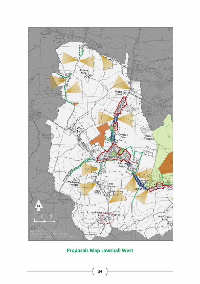
54
Proposals Map Lawshall West
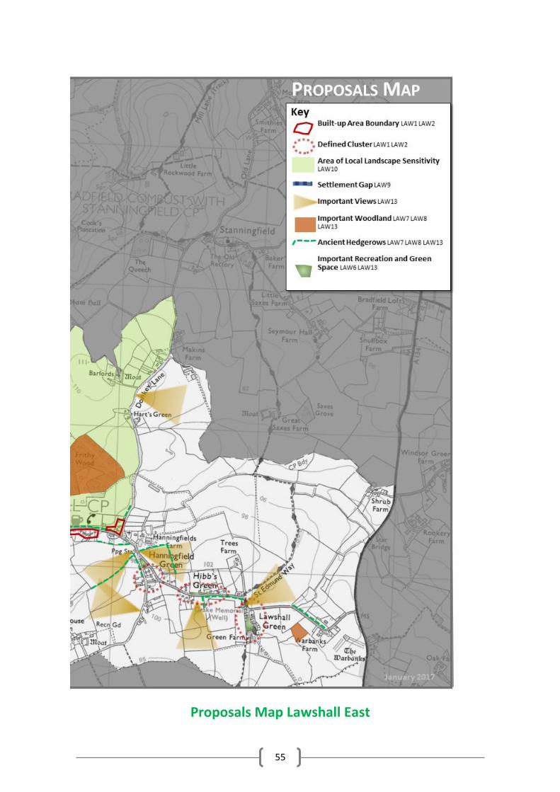
55
Proposals Map Lawshall East
56
GLOSSARY Affordable housing: Social rented, affordable rented and intermediate housing, provided to eligible households whose needs are not met by the market. Eligibility is determined with regard to local incomes and local house prices.
Archaeological interest: There will be archaeological interest in a heritage asset if it holds, or potentially may hold, evidence of past human activity worthy of expert investigation at some point. Heritage assets with archaeological interest are the primary source of evidence about the substance and evolution of places, and of the people and cultures that made them.
Best and most versatile agricultural land: Land in grades 1, 2 and 3a of the Agricultural Land Classification.
Birds and Habitats Directives: European Directives to conserve natural habitats and wild fauna and flora.
Buildings of local interest: Locally important building valued for its contribution to the local scene or for local historical situations but not meriting listed status.
Built-up Area Boundary: These are defined in the Babergh Local Plan 2006 and the policies in the Babergh Core Strategy 2014 also refers to them. They are a planning term that do not necessarily include all buildings within the boundary.
Conservation (for heritage policy): The process of maintaining and managing change to a heritage asset in a way that sustains and, where appropriate, enhances its significance.
Community Infrastructure Levy: A levy allowing local authorities to raise funds from owners or developers of land undertaking new building projects in their area.
Designated heritage asset: A World Heritage Site, Scheduled Monument, Listed Building, Protected Wreck Site, Registered Park and Garden, Registered Battlefield or Conservation Area designated under the relevant legislation.
Development plan: This includes adopted Local Plans and neighbourhood plans as defined in section 38 of the Planning and Compulsory Purchase Act 2004.
Exception sites for affordable housing: Sites for affordable housing development in rural locations where market housing would not normally be acceptable because of planning policy constraints. Homes can be brought forward on these sites only if there is a proven unmet local need for affordable housing and a legal planning agreement is in place to ensure that the homes will always remain affordable, will be for people in housing need and prioritised for those with a strong local connection to the parish.
Green infrastructure: A network of multi-functional green space, urban and rural, which is capable of delivering a wide range of environmental and quality of life benefits for local communities.
Heritage asset: A term that includes designated heritage assets (e.g. listed buildings, world heritage sites, conservation areas, scheduled monuments, protected wreck sites, registered parks and gardens and battlefields) and non-designated assets identified by the local planning authority. Non-designated heritage assets include sites of archaeological interest, buildings, structures or features of local heritage interest listed by, or fulfilling criteria for listing by, the local planning authority.
Hinterland Village: Defined in the Babergh Core Strategy 2014 as villages that tend to be small, with very limited facilities and so are dependent on nearby larger villages or urban areas for many of their everyday needs.
Historic environment: All aspects of the environment resulting from the interaction between people and places through time, including all surviving physical remains of past human activity, whether visible, buried or submerged, and landscaped and planted or managed flora.
57
International, national and locally designated sites of importance for biodiversity: All international sites (Special Areas of Conservation, Special Protection Areas, and Ramsar sites), national sites (Sites of Special Scientific Interest) and locally designated sites including Local Wildlife Sites.
Local planning authority: The public authority whose duty it is to carry out specific planning functions for a particular area which in this case is Babergh District Council.
Local Plan: The plan for the future development of the local area, drawn up by the local planning authority in consultation with the community.
Neighbourhood plans: A plan prepared by a Parish Council or Neighbourhood Forum for a particular neighbourhood area (made under the Planning and Compulsory Purchase Act 2004).
Open space: All open space of public value, including not just land, but also areas of water (such as rivers, canals, lakes and reservoirs) which offer important opportunities for sport and recreation and can act as a visual amenity.
Renewable and low carbon energy: Includes energy for heating and cooling as well as generating electricity. Renewable energy covers those energy flows that occur naturally and repeatedly in the environment – from the wind, the fall of water, the movement of the oceans, from the sun and also from biomass and deep geothermal heat. Low carbon technologies are those that can help reduce emissions (compared to conventional use of fossil fuels).
Rural exception sites: Small sites used for affordable housing in perpetuity where sites would not normally be used for housing. Rural exception sites seek to address the needs of the local community by accommodating households who are either current residents or have an existing family or employment connection. Small numbers of market homes may be allowed at the local authority’s discretion, for example where essential to enable the delivery of affordable units without grant funding.
Setting of a heritage asset: The surroundings in which a heritage asset is experienced. Its extent is not fixed and may change as the asset and its surroundings evolve. Elements of a setting may make a positive or negative contribution to the significance of an asset, may affect the ability to appreciate that significance or may be neutral.
Significance (for heritage policy): The value of a heritage asset to this and future generations because of its heritage interest. That interest may be archaeological, architectural, artistic or historic. Significance derives not only from a heritage asset’s physical presence, but also from its setting.
Site of Special Scientific Interest: Sites designated by Natural England under the Wildlife and Countryside Act 1981.
Strategic Environmental Assessment: A procedure (set out in the Environmental Assessment of Plans and Programmes Regulations 2004) which requires the formal environmental assessment of certain plans and programmes which are likely to have significant effects on the environment.
Use Classes: The Town and Country Planning (Use Classes) Order 1987 (as amended) puts uses of land and buildings into various categories known as ‘Use Classes’.
Wildlife corridor: Areas of habitat connecting wildlife populations.
58
APPENDICES & SUPPORTING DOCUMENTS
Appendices Appendix 1 Village Appraisal Summaries
-1979 Appraisal summarised by J & H Norman, Hanningfield Green -1991 Appraisal summarised by P Walker, Hibbs Green
Appendix 2 Biodiversity In Lawshall with tables of fauna & flora surveys -C Osborne, Melon Green, assisted by G Clarke, The Street and Ros Debenham, Melford Rd -Birds: C Cooper, The Glebe -Butterflies: W Cooper, The Glebe -Plants: Lavenham Natural History Group -Lawshall Green: R Edelman & N Hughes, Lawshall Green
Appendix 3 Listed Buildings of Lawshall -Archive Group Appendix 4 Lawshall’s Buildings & Structures of Note -Archive Group & P Harber, Bury Rd Appendix 5 Lawshall’s Special House Features -R Debenham, Melford Rd & P Harber, Bury Rd Appendix 6 NP Team and 2nd Tier Helpers
Supporting Documents (available on the NP page of Lawshall Parish Council website) Basic Conditions Statement Community Consultation Statement Lawshall Character Assessment SEA Screening Report Proposals Map - A3 Version Lawshall Hedgerow Survey Maps NP Team Mission Statement & Terms of Reference Community Engagement Strategy Results of 1st & 2nd Community Consultations Village Questionnaire Housing Needs Survey Results of Village Questionnaire & Housing Needs Survey Census Information for Lawshall - comparison of 2001 & 2011 Census statistics
Loving our village – past, present, future!
59
APPENDIX ONE: Village Appraisal Summaries 1979 Lawshall Village Appraisal
- summarised by J&H Norman, Hanningfield Green (Aug ’16) Introduction: The Appraisal questionnaire had the following sections:
Population / Transport Housing / Employment Amenities / Health Service Conservation of the environment / Miscellaneous The above is preceded by village description and historical survey. It is concluded by a summary of views expressed. In reading this document it must be remembered that it was prepared before the Harrow Green development (The Glebe) was occupied. The general impression was that people are fond of Lawshall, find it a good place to live and wanted to keep it a living community without becoming a dormitory for Bury or Sudbury. Just over 200 forms were distributed and around 80% were returned. LAWSHALL PAST AND PRESENT (History of Lawshall until 1900) Lawshall has a scattered distribution of properties. The grouping of the shop, church and school represent the centre of the village. There is early evidence of a settlement in the pre-Roman period at Warbanks, where a late Bronze Age sword was found dating from around 800-600 BC. Lawshall is listed in the Domesday Book (1086) and documentary evidence shows various Lords of the Manor including a Sir William Drury, whose family had royal connection making possible the visit of Queen Elizabeth I to Lawshall in 1587. The Rookwood family had previously requested she visit Coldham Hall, however it appears that their Catholic faith left them out of favour. Later Ambrose Rookwood was involved in the conspiracy to murder James I by blowing up the houses of Parliament. Having heard of the arrest of Guy Fawkes; Ambrose fled with Catesbury only to be arrested and executed in 1605. There are several important pieces of documentation of the village, its occupants, maps and tax records from the C16th providing good information on social population changes. The C19th was a period of rapid change for the village as shown in the census reports of 1801–1911. The population in 1801 was 550. An increase demand of agriculture produce during the Napoleonic wars increased prices and therefore standards of living. Later improved farming methods, artificial fertilizers and the mechanization of equipment took Lawshall’s population to its highest ever total of 925 in 1841. Trade directories show in the second half of the C19th the village was a mainly self-sufficient community that also provided services and goods outside the village; for example, the horsehair factory and the rake and hurdle makers. The arrival of the railway (Cockfield Station) bought a boost to industries with the ability to transport goods to a wider market. From the mid-1870s an agricultural depression hit forcing many families to move away to find work. Wheat production in other developing countries flooded the market and bought a crash in prices of grain producing areas including Lawshall. There was a 25% reduction in the village population from 1874 – 1911. The depression lasted until the First World War when agriculture was again stimulated by demand.
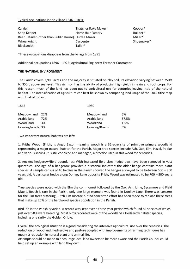
60
Typical occupations in the village 1846 – 1891: Carrier Thatcher Rake Maker Cooper* Shop Keeper Horse Hair Factory Builder* Beer Retailer (other than Public House) Hurdle Maker Miller* Wheelwright Carpenter Shoemaker* Blacksmith Tailor* *These occupations disappear from the village from 1891 Additional occupations 1896 – 1922: Agricultural Engineer; Thrasher Contractor THE NATURAL ENVIRONMENT The Parish covers 2,900 acres and the majority is situated on clay soil, its elevation varying between 250ft to 350ft above sea level. This rich soil has the ability of producing high yields in grain and root crops. For this reason, much of the land has been put to agricultural use for centuries leaving little of the natural habitat. The intensification of agriculture can best be shown by comparing land usage of the 1842 tithe map with that of today. 1842 1980 Meadow land 22% Meadow land 6% Arable land 72% Arable land 87.5% Wood land 3% Woodland 1.5% Housing/roads 3% Housing/Roads 5% Two important natural habitats are left: 1. Frithy Wood: (Frithy is Anglo Saxon meaning wood) Is a 32-acre site of primitive primary woodland representing a major natural habitat for the Parish. Major tree species include Ash, Oak, Elm, Hazel, Poplar and various shrubs. It is still coppiced and managed, a practice used in this wood for centuries. 2. Ancient hedgerow/field boundaries: With increased field sizes hedgerows have been removed in vast quantities. The age of a hedgerow provides a historical indicator; the older hedge contains more plant species. A sample census of 40 hedges in the Parish showed the hedges surveyed to be between 500 – 900 years old. A particular hedge along Donkey Lane opposite Frithy Wood was estimated to be 700 – 800 years old. Tree species were noted with the Elm the commonest followed by the Oak, Ash, Lime, Sycamore and Field Maple. Beech is rare in the Parish, only one large example was found in Donkey Lane. There was concern for the Elm trees suffering Dutch Elm Disease but no concerted effort has been made to replace these trees that make up 25% of the hardwood species population in the Parish. Bird life in the Parish is varied. A record was kept over a three-year period which found 82 species of which just over 50% were breeding. Most birds recorded were of the woodland / Hedgerow habitat species, including one rarity the Golden Oriole. Overall the ecological situation is a good considering the intensive agricultural use over the centuries. The reduction of woodland, hedgerows and pasture coupled with improvements of farming techniques has meant a reduction in natural plant and animal life. Attempts should be made to encourage local land owners to be more aware and the Parish Council could help set up an example with land they own.
61
Population: During the 1979 appraisal important questions asked were as follows: 1. How long have you lived in the village? On average there are equal proportions of new comers to people who have lived here most of their lives. 2. How long do you expect to stay? The vast majority intended to stay. Population of Lawshall: 1951 516 1961 543 1971 649 The last census taken was 1971. Projected estimates by Suffolk County Council are as follows: 1975 676 1976 670 1981 910 Estimates indicate the village will grow during 1976 – 1981 by 1.5 times more than actual growth recorded in the proceeding 25 years. The Harrow Green Development must account largely for the projected increase. Households: 1971 Shows Lawshall with 244 households: 39 Council rented / 160 Owner occupier / 25 Privately rented Age groups within households replying to the questionnaire showed the greatest numbers between 24-59 yrs of age followed by those 65 years and over. Transport: The majority of transport was private, used for going to work, shopping, recreational activities, including visiting friends outside Bury St Edmunds. Good support for a minibus to Bury or Sudbury was given as the bus Service was available to Bury St Edmunds but appeared limited with no service out of the village in the evenings and on Sunday. Travel by public transport to Sudbury or Colchester was not available. Housing: Approximately 61% of the 146 replies expressed an overwhelming view that housing provision was inadequate. 23% stated that they had insufficient knowledge to give an informed opinion. Suggestions were made for pressing housing needs, i.e. elderly, young marrieds, few criticised the preventions of self-build projects because of the Suffolk Development Plan. Industry/Employment: A question on the encouragement of small industry and the need for employment opportunities within the Parish was answered overwhelmingly with a majority against.
62
Amenities: It appeared that Lawshall had adequate general amenity facilities within the village. The exceptions being the lack of play areas, provision of litter bins and sports facilities (cricket and football pitches) and youth organizations (cubs and brownies) Health Services: Lawshall is served by two doctor’s surgeries, Long Melford and Glemsford. A doctor visits the village from the Long Melford practice once a week and to hold a surgery in the village hall. Replies to this part of the questionnaire underline an over stretched medical service with a totally inadequate public transport system that hinders access to both G.P.s and hospital. Ambulance and hospital car service are essential for outpatient visits, there is also a lack of a dispensary the nearest being Long Melford or Bury. Conservation and Environment: Buildings of interest in the village, Lawshall Hall attracted most attention to be preserved, the Church with its avenue of lime trees, Keeper’s Cottage, the School and Drakes Well also attracted interest. Coldham Hall and gatehouse although outside the Parish attracted specific attention for preservation. With regard to natural features 24% requested the preservation of hedges, trees, greens, roadside verges and ponds. Of the 69 comments received 26% referred to Hanningfield Green as the village eyesore, with main concern given to the state of the pond, general untidiness and the many parked vehicles. Miscellaneous - Questions and answers: 1. Ideas for improving the quality of life in the village? It appears that the preservation of the village atmosphere is important and therefore keeping development at a minimum. 2. Are you satisfied with the work of the Parish Council? There was a lack of knowledge of how the Parish Council works and its powers. 3. Are you prepared to help with time etc.? The response to help was positive 4. Important points overlooked in the questionnaire? This included traffic flow in the village, a lack of street lighting and a mains gas supply. Requests for road improvements and signage for field pathways were made. The Harrow Green development, although accepted, would make a considerable difference to the community, who were resolutely against any further large development. The population increase would impact on an already overstretched health service, inadequate public transport system and educational facilities, also affecting traffic volume. There was a lack of amenities for young people and volunteers to run organizations. The greatest need was improvement in public transport, plus provision of facilities for medical practitioners. There is a solid base of good will and people must be involved. Improved shopping facilities would only work if they are viable and used by the community. More could be done to keep the village tidy and attractive.
63
Recommendations: 1) The improvement of public transport 2) Find helpers for the youth groups 3) Provide facilities for Doctors within the village 4) Plant hardwood trees to replace the Elms lost and keep up pond maintenance 5) Enter “Best Kept Village” in the future. Appendices: Statistical Analysis of amenities / Statistical analysis of Health services / Listed buildings of the Parish /Check list of birds recorded in the Parish 1976 – 1979. 1991 Village Appraisal - summarised by P Walker, Hibbs Green (Sept ’16) The 1991 appraisal was undertaken at the suggestion of the Community Council for Suffolk. It was carried out on behalf of the PC by Lawshall Local History Group who distributed a questionnaire during October 1991 to 724 adults on the electoral register. There were 520 returns (71.8%). (NOTE: Summary of the history section is omitted since it was fairly similar to the equivalent section as given in the summary of the 1979 Appraisal) Population 244 men & 276 women, with 148 children. <5 5-10 10-16 17-24 25-44 45-59 60-65 >65
48 39 61 32 165 101 57 141
11% were born in Lawshall. 62% moved here within the past 10 years (and 78% in the past 20 years). 16% moved here to retire; 15% to be with family; and 8% for employment prospects. Quality of Environment was the most common reason for choosing to move to Lawshall. Housing Owner/Occupier Council rented Privately Rented Tied Cottages
264 (82.8 %) 35 (10.9 %) 8 (2.5 %) 12 (3.8%)
Most, 275 (55%) did not want more housing in the village (138 yes & 87 don't know). Of the yes, mixed development (67) was the favoured type. Employment & Occupation Full
Employment Self Employed Retired Unemployed Student Part-time
195 (40%) 75 (15%) 178 (37%) 25 (5%) 7 (1%) 2
There were 66 different occupations, a variety of skills and experience. Response to more employment opportunities in the village was mixed (36% no, 30% yes, 34% don't know) Most work outside Lawshall (7%) with Sudbury (11%), Bury (9%) & Cambridge (5%) most common 85% were employed within Suffolk.
64
Transport # of Cars none one two three four five
Houses 18 137 106 22 2 1
For commuting 1 used the daily bus service. 23 the weekly service and 99 buses occasionally, with respondents considering the Bury and Sudbury services infrequent and unreliable with a lack of service details. 354 used their own transport exclusively. For shopping Bury (382) was the main choice, Sudbury (76) Lawshall (20) Long Melford (14).1390 Shopping also commonly occurred around the area of commuted work.1391 Amenities There was a high level of satisfaction with and use of the village hall by the organisations in the village. The mobile library and bus shelters were deemed adequate. But Litter bins were cited as inadequate. Lack of amenities for young people was observed, with requests for more play areas and sports facilities. The Primary School (90 pupils) had an enlarged catchment area (Alpheton, Shimpling & Hawstead) Health Services There was an adequate weekly surgery held in the village hall, with most others frequenting; Long Melford (205), Bury (140), Hartest (110), Glemsford (5), Sudbury (4), Lavenham (3), Bildeston (1). Health care was predominately (450) reached via private transport with 38 using hospital car service. Conservation & the Environment A strong desire was expressed to conserve village heritage -the views, trees (11%), hedgerows, thatched houses -specifically some buildings including All Saints Church (27%), Lawshall Hall (12%), The Swan Inn and the Village Hall and some areas getting special mention -Frithy Wood (6%), the pond (5%), and Hanningfield Green. There were complaints about rubbish in the ditches in Lambs Lane and Kelso Place 191 people wanted more footpaths, 79 did not wish for more, with 153 undecideds. Requests were made for circular walks. Miscellaneous There were at least 148 children under the age of 16 in the village - facilities for the young were considered overdue. Other requests included: speed limits, street lighting, a children's sports field, more trees and hedges. The Parish council was well regarded for maintaining the quality of life in the village. Recommendations Provide more public facilities for youngsters / Perform another appraisal in 10 years / Improve public transport / Improve and expand footpaths / More trees and hedges to enhance the village scene.
65
Comparisons and Contrasts In the 1991 Appraisal, there are several mentions and comparisons made with the previous appraisal in 1979, 12 years earlier. Just over 200 were distributed with about 80% response, and again not all questions were answered by all. Since the 1979 appraisal the "new" Glebe and Shepherds Drive areas had been added to the village and as of 1991 accounted for approx. 25% of the population. These areas specifically gave an increase in newcomers to the village (young people and children) with a corresponding decrease in the percentage of lifers. It did not mean that older people left the village, but it did give a mixture of all age groups, a shift of population centre to near Village Hall, the Primary School was enlarged and social life in the village increased including 23 voluntary organisations. Generally, Lawshall continued to be a well thought-of, pleasant place to live. Public transport continued to be in need of improvement (notwithstanding the Sudbury bus being introduced between 1979 and 1991). Visiting Doctor facilities were considered just adequate and there were continuing demands for more footpaths and a speed limit. Increasingly diverse job locations and sparse public transport meant that car ownership was increasingly essential. The majority did not wish more housing or greater employment opportunities -but then they already had houses -whether this desire changed as the 148 then children grew into (young) adults is unknown. In short, the villagers appreciated Lawshall as it was, and did not want anything to change or upset their tranquillity. 25 years have now passed since the last appraisal. The Post Office has closed and as of the time of writing the village shop is closing. The internet has enabled instantaneous communication with on demand delivery of all imaginable products and services, not least mainstream home shopping, teleworking, and entertainment. Broadband and Wi-Fi services are now considered necessary, provisions not envisioned in 1991. (Both Appraisals are available on request from Lawshall Archive Group)
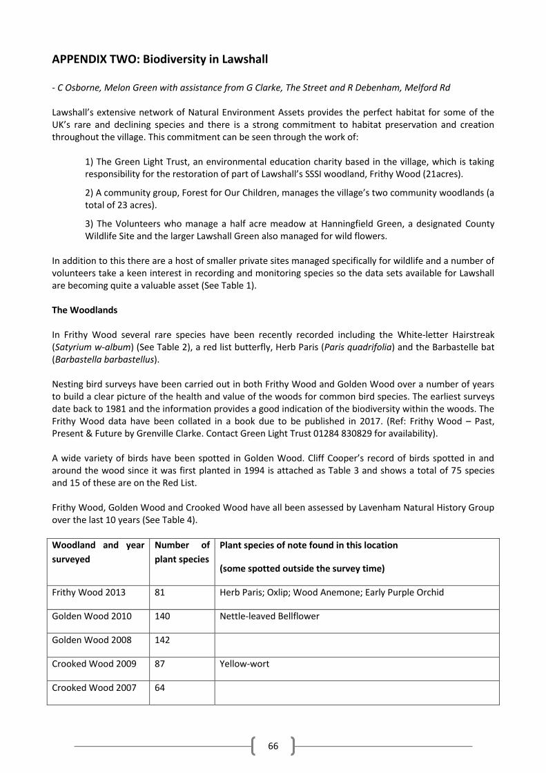
66
APPENDIX TWO: Biodiversity in Lawshall - C Osborne, Melon Green with assistance from G Clarke, The Street and R Debenham, Melford Rd Lawshall’s extensive network of Natural Environment Assets provides the perfect habitat for some of the UK’s rare and declining species and there is a strong commitment to habitat preservation and creation throughout the village. This commitment can be seen through the work of:
1) The Green Light Trust, an environmental education charity based in the village, which is taking responsibility for the restoration of part of Lawshall’s SSSI woodland, Frithy Wood (21acres).
2) A community group, Forest for Our Children, manages the village’s two community woodlands (a total of 23 acres).
3) The Volunteers who manage a half acre meadow at Hanningfield Green, a designated County Wildlife Site and the larger Lawshall Green also managed for wild flowers.
In addition to this there are a host of smaller private sites managed specifically for wildlife and a number of volunteers take a keen interest in recording and monitoring species so the data sets available for Lawshall are becoming quite a valuable asset (See Table 1). The Woodlands In Frithy Wood several rare species have been recently recorded including the White-letter Hairstreak (Satyrium w-album) (See Table 2), a red list butterfly, Herb Paris (Paris quadrifolia) and the Barbastelle bat (Barbastella barbastellus). Nesting bird surveys have been carried out in both Frithy Wood and Golden Wood over a number of years to build a clear picture of the health and value of the woods for common bird species. The earliest surveys date back to 1981 and the information provides a good indication of the biodiversity within the woods. The Frithy Wood data have been collated in a book due to be published in 2017. (Ref: Frithy Wood – Past, Present & Future by Grenville Clarke. Contact Green Light Trust 01284 830829 for availability). A wide variety of birds have been spotted in Golden Wood. Cliff Cooper’s record of birds spotted in and around the wood since it was first planted in 1994 is attached as Table 3 and shows a total of 75 species and 15 of these are on the Red List. Frithy Wood, Golden Wood and Crooked Wood have all been assessed by Lavenham Natural History Group over the last 10 years (See Table 4).
Woodland and year
surveyed
Number of
plant species
Plant species of note found in this location
(some spotted outside the survey time)
Frithy Wood 2013 81 Herb Paris; Oxlip; Wood Anemone; Early Purple Orchid
Golden Wood 2010 140 Nettle-leaved Bellflower
Golden Wood 2008 142
Crooked Wood 2009 87 Yellow-wort
Crooked Wood 2007 64
67
Lawshall also has several recently planted private woodlands. These include: Theobalds Park which abuts Crooked Wood; 4.5-acre woodland, thicket and wildflower meadow at Farm and Moss Cottages on Lawshall Green and a maturing woodland at Oakwood, Audley End. The Hedgerows Residents consider themselves lucky to still be able to hear the purring of Turtle Doves in the village. This is a red list species and two breeding pairs have been recorded in the village in 2016, with others heard calling regularly on the outskirts of the village. This species and many more, benefit from Lawshall’s pockets of dense scrub and extensive network of ancient hedgerows. The ancient hedgerows provide valuable wildlife corridors and a diverse range of plants for animals to live on. In 2012 an extensive hedgerow survey was completed by village conservationists, A Walters and G Clarke, as part of the Suffolk hedgerow recording scheme. The survey found that Lawshall Parish has an above average percentage of species rich hedgerows and some date back to before 1611. The impressive detailed map of their findings can be viewed on request. The Wildflower Meadows Lawshall has carefully managed wildflower meadows at Hanningfield Green, Lawshall Green and in Golden Wood. There are also several privately managed wildflower meadows. These include: The Foundry on Bury Road, Farm and Moss Cottage at Lawshall Green, Hills Farmhouse on Bury Road, Oakwood at Audley End and Freors on The Street. The most unusual wildflowers found on the meadows so far are the Adder’s-tongue Fern (Ophioglossum vulgatum), the Cuckoo Flower (Cardamine pratensis) and a range of orchids (Bee Orchid, Pyramidal Orchid, Common Spotted Orchid). Ponds Lawshall has a number of small ponds which are often in spots close to housing as dew ponds on agricultural land have tended to be lost. Ponds are very beneficial to wildlife and, with this in mind, ponds have been created near to Melford Road and also in Golden Wood. The large pond created in Golden Wood has taken time to become established, but it now has excellent water quality. Lawshall’s ponds were assessed in the 1990’s and Great Crested Newts found at several locations including at The Foundry on Bury Road, in Golden Wood, at Rectory Corner and at Silver Farm, Hibbs Green and it’s likely that they can still be found locally so ponds near to building land will need to be assessed when necessary.
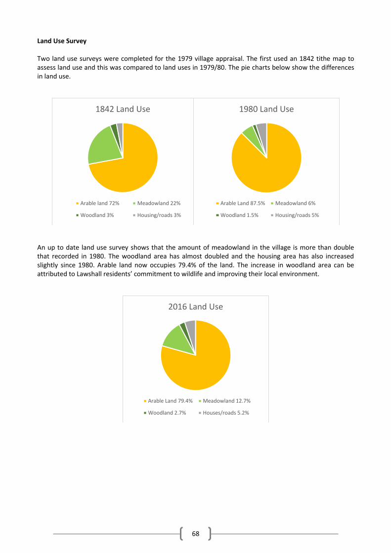
68
Land Use Survey Two land use surveys were completed for the 1979 village appraisal. The first used an 1842 tithe map to assess land use and this was compared to land uses in 1979/80. The pie charts below show the differences in land use.
An up to date land use survey shows that the amount of meadowland in the village is more than double that recorded in 1980. The woodland area has almost doubled and the housing area has also increased slightly since 1980. Arable land now occupies 79.4% of the land. The increase in woodland area can be attributed to Lawshall residents’ commitment to wildlife and improving their local environment.
1842 Land Use
Arable land 72% Meadowland 22%
Woodland 3% Housing/roads 3%
1980 Land Use
Arable Land 87.5% Meadowland 6%
Woodland 1.5% Housing/roads 5%
2016 Land Use
Arable Land 79.4% Meadowland 12.7%
Woodland 2.7% Houses/roads 5.2%
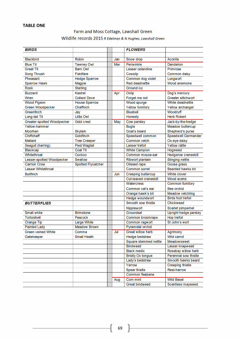
69
TABLE ONE
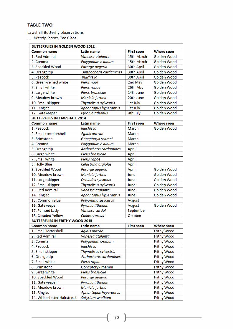
70
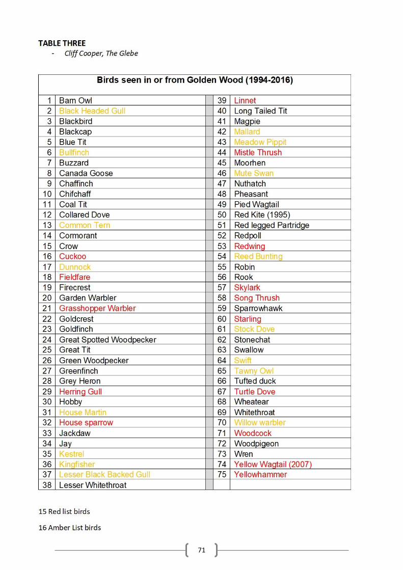
71
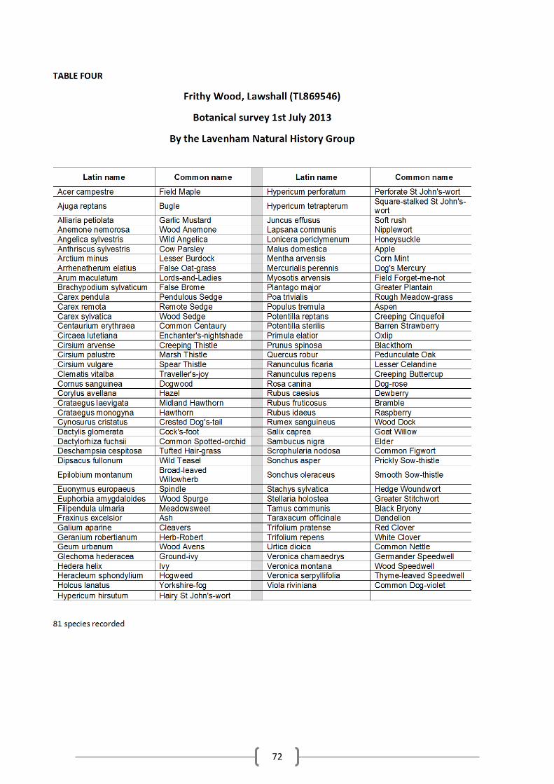
72
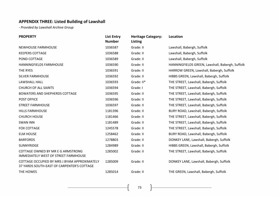
73
APPENDIX THREE: Listed Building of Lawshall - Provided by Lawshall Archive Group
PROPERTY List Entry Number
Heritage Category: Listing
Location
NEWHOUSE FARMHOUSE 1036587 Grade: II Lawshall, Babergh, Suffolk
KEEPERS COTTAGE 1036588 Grade: II Lawshall, Babergh, Suffolk
POND COTTAGE 1036589 Grade: II Lawshall, Babergh, Suffolk
HANNINGFIELDS FARMHOUSE 1036590 Grade: II HANNINGFIELDS GREEN, Lawshall, Babergh, Suffolk
THE RYES 1036591 Grade: II HARROW GREEN, Lawshall, Babergh, Suffolk
SILVER FARMHOUSE 1036592 Grade: II HIBBS GREEN, Lawshall, Babergh, Suffolk
LAWSHALL HALL 1036593 Grade: II* THE STREET, Lawshall, Babergh, Suffolk
CHURCH OF ALL SAINTS 1036594 Grade: I THE STREET, Lawshall, Babergh, Suffolk
BOWATERS AND SHEPHERDS COTTAGE 1036595 Grade: II THE STREET, Lawshall, Babergh, Suffolk
POST OFFICE 1036596 Grade: II THE STREET, Lawshall, Babergh, Suffolk
STREET FARMHOUSE 1036597 Grade: II THE STREET, Lawshall, Babergh, Suffolk
HILLS FARMHOUSE 1181396 Grade: II BURY ROAD, Lawshall, Babergh, Suffolk
CHURCH HOUSE 1181466 Grade: II THE STREET, Lawshall, Babergh, Suffolk
SWAN INN 1181489 Grade: II THE STREET, Lawshall, Babergh, Suffolk
FOX COTTAGE 1245578 Grade: II THE STREET, Lawshall, Babergh, Suffolk
ELM HOUSE 1258462 Grade: II BURY ROAD, Lawshall, Babergh, Suffolk
BARFORDS 1278803 Grade: II DONKEY LANE, Lawshall, Babergh, Suffolk
SUNNYRIDGE 1284989 Grade: II HIBBS GREEN, Lawshall, Babergh, Suffolk
COTTAGE OWNED BY MR E G ARMSTRONG IMMEDIATELY WEST OF STREET FARMHOUSE
1285002 Grade: II THE STREET, Lawshall, Babergh, Suffolk
COTTAGE OCCUPIED BY MRS J BYAM APPROXIMATELY 37 YARDS SOUTH-EAST OF CARPENTER'S COTTAGE
1285009 Grade: II DONKEY LANE, Lawshall, Babergh, Suffolk
THE HOWES 1285014 Grade: II THE GREEN, Lawshall, Babergh, Suffolk
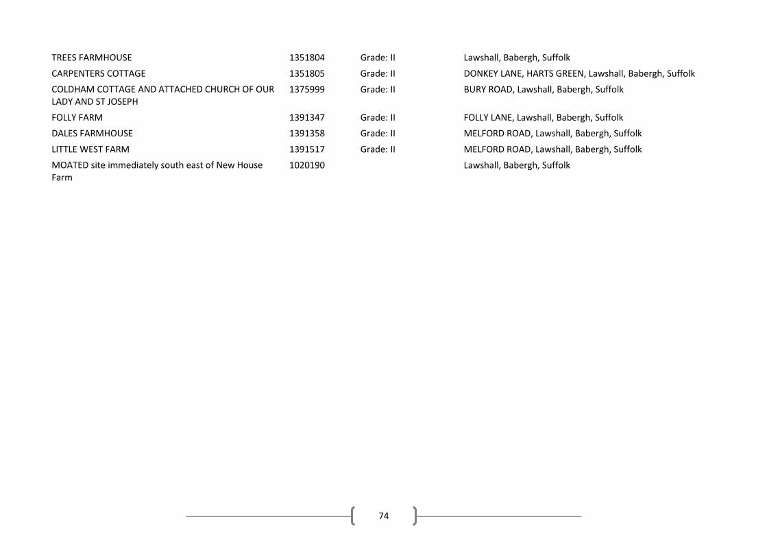
74
TREES FARMHOUSE 1351804 Grade: II Lawshall, Babergh, Suffolk
CARPENTERS COTTAGE 1351805 Grade: II DONKEY LANE, HARTS GREEN, Lawshall, Babergh, Suffolk
COLDHAM COTTAGE AND ATTACHED CHURCH OF OUR LADY AND ST JOSEPH
1375999 Grade: II BURY ROAD, Lawshall, Babergh, Suffolk
FOLLY FARM 1391347 Grade: II FOLLY LANE, Lawshall, Babergh, Suffolk
DALES FARMHOUSE 1391358 Grade: II MELFORD ROAD, Lawshall, Babergh, Suffolk
LITTLE WEST FARM 1391517 Grade: II MELFORD ROAD, Lawshall, Babergh, Suffolk
MOATED site immediately south east of New House Farm
1020190 Lawshall, Babergh, Suffolk

75
APPENDIX FOUR: Lawshall’s Buildings and Structures of Note - Compiled by Lawshall Archive Group and Timber Frame Specialist, P Harber
The purpose of recording these special buildings of note is to raise the built heritage profile of Lawshall. The ‘local list’ would in no way restrict the buildings, but would help to secure their long-term protection and help to ensure that their settings are not disturbed or infringed upon by new development. Proposed criteria for ‘local list’: The dwelling, building or structure would need to fulfil at least one of the following:
Have records or signs of historic interest/significance
Display architectural features of interest/ unusualness/ particular masterly craftsmanship
Be distinctively individual/ unique / characterful /curious /charming
Show features /materials/ building methods indicative of and/or special to Lawshall and/or the local area.
And overall, enhance the character of the village which is a mix of old and new, listed and unlisted houses and buildings in scattered hamlets, along the main through roads, in a central ‘hub’, and along our winding lanes. Proposed list of possible buildings for consideration: This NP recognises that these buildings could satisfy the criteria to be listed as local heritage assets. However, the NP does not designate buildings and this will be left to a separate piece of work that will involve full discussions with the property owners prior to their inclusion on any list. The possible list was displayed at the 2nd community consultation and was deemed ‘Very Important’ by the respondees. The dwellings and other buildings and structures are grouped together as follows: Rectory Corner Crossways - part timber framed, Victorianised. Garden House - (not Farm), core 16th century timber framed, later Georgianised. Bayleaf House - 15th Century, possibly a former open hall house, mullion windows. Wintles, Old Rectory & the Barn House - all three old and worthy of note. Golden Lane Moat House - timber framed at front encased in brick late. Moat Farm - 16th century timber framed house at front, later period extensions to rear. Mill Cottage - 17th century timber framed cottage. Thatched barn. Lawshall Green Green Farm, part clay lump and timber framed cottage. Moss Cottage - Victorian//Edwardian, tied cottage until 1993. Farm Cottage -16th century, timber framed and largely un-modernised. Drake’s Well – 19th century timbered memorial to naturalist, Charles Frederick Drake (1846 – 1874). The Street Corneys Cottage - Victorian/Georgian. Longstop Cottage - timber framed. Pantile Cottage - timber framed. Roselen, April Cottage, Mossford – distinctive Victorian terrace. Melford Road Coopers Farm house - timber framed. Audley End House - Georgian rendered white brick.
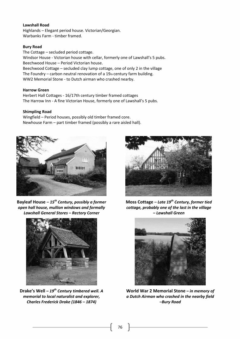
76
Lawshall Road Highlands – Elegant period house. Victorian/Georgian. Warbanks Farm - timber framed. Bury Road The Cottage – secluded period cottage. Windsor House - Victorian house with cellar, formerly one of Lawshall’s 5 pubs. Beechwood House – Period Victorian house. Beechwood Cottage – secluded clay lump cottage, one of only 2 in the village The Foundry – carbon neutral renovation of a 19th century farm building. WW2 Memorial Stone - to Dutch airman who crashed nearby. Harrow Green Herbert Hall Cottages - 16/17th century timber framed cottages The Harrow Inn - A fine Victorian House, formerly one of Lawshall’s 5 pubs. Shimpling Road Wingfield – Period houses, possibly old timber framed core. Newhouse Farm – part timber framed (possibly a rare aisled hall).
Bayleaf House – 15th Century, possibly a former open hall house, mullion windows and formally
Lawshall General Stores – Rectory Corner
Moss Cottage – Late 19th Century, former tied cottage, probably one of the last in the village
– Lawshall Green
Drake’s Well – 19th Century timbered well. A memorial to local naturalist and explorer,
Charles Frederick Drake (1846 – 1874)
World War 2 Memorial Stone – in memory of a Dutch Airman who crashed in the nearby field
–Bury Road
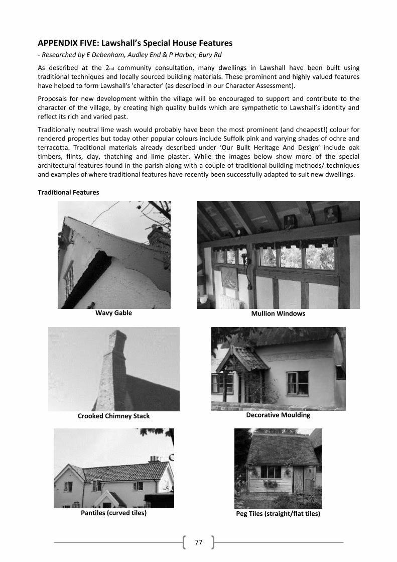
77
APPENDIX FIVE: Lawshall’s Special House Features - Researched by E Debenham, Audley End & P Harber, Bury Rd
As described at the 2nd community consultation, many dwellings in Lawshall have been built using traditional techniques and locally sourced building materials. These prominent and highly valued features have helped to form Lawshall's 'character' (as described in our Character Assessment).
Proposals for new development within the village will be encouraged to support and contribute to the character of the village, by creating high quality builds which are sympathetic to Lawshall’s identity and reflect its rich and varied past.
Traditionally neutral lime wash would probably have been the most prominent (and cheapest!) colour for rendered properties but today other popular colours include Suffolk pink and varying shades of ochre and terracotta. Traditional materials already described under ‘Our Built Heritage And Design’ include oak timbers, flints, clay, thatching and lime plaster. While the images below show more of the special architectural features found in the parish along with a couple of traditional building methods/ techniques and examples of where traditional features have recently been successfully adapted to suit new dwellings. Traditional Features
Wavy Gable
Mullion Windows
Crooked Chimney Stack
Decorative Moulding
Pantiles (curved tiles)
Peg Tiles (straight/flat tiles)
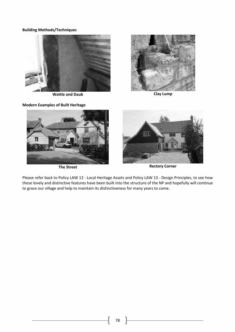
78
Building Methods/Techniques
Wattle and Daub
Clay Lump
Modern Examples of Built Heritage
The Street
Rectory Corner
Please refer back to Policy LAW 12 - Local Heritage Assets and Policy LAW 13 - Design Principles, to see how these lovely and distinctive features have been built into the structure of the NP and hopefully will continue to grace our village and help to maintain its distinctiveness for many years to come.
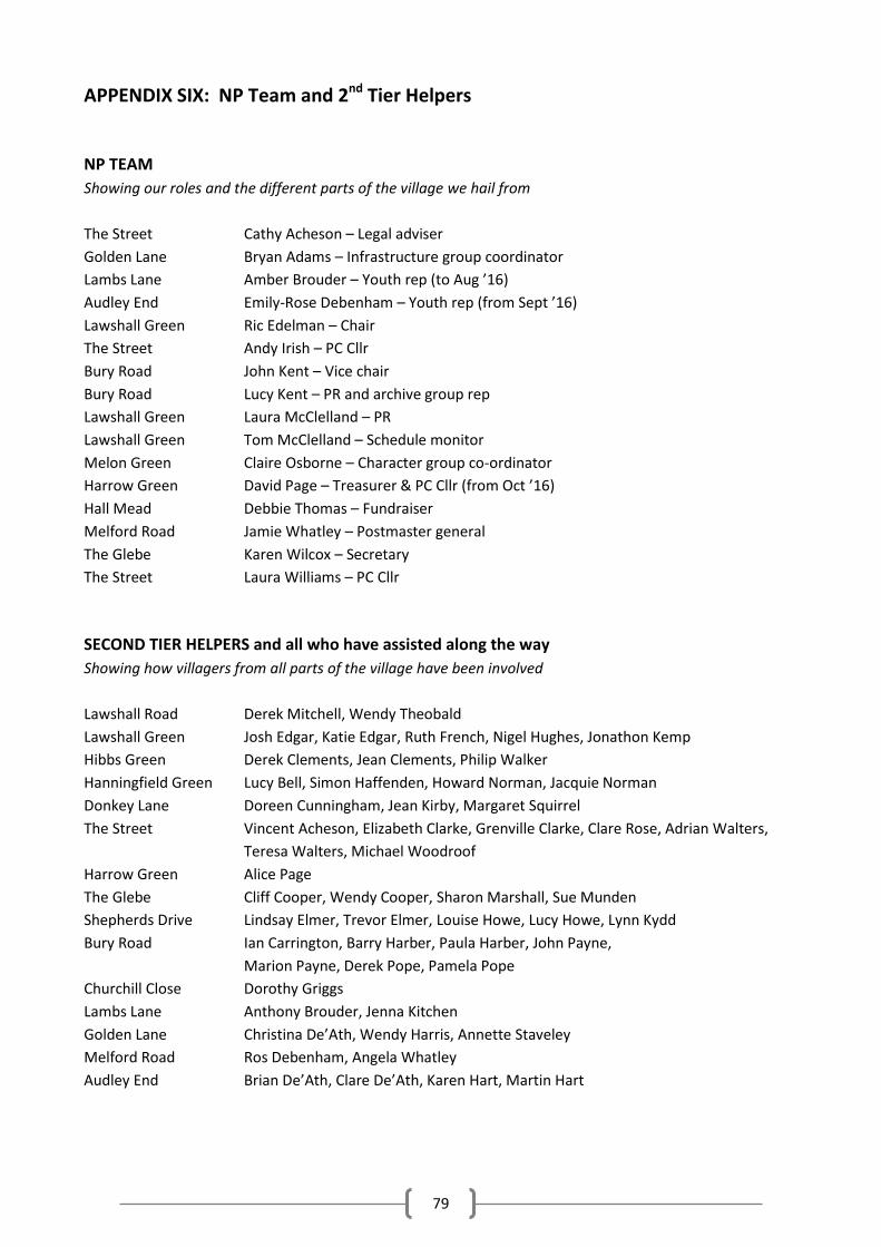
79
APPENDIX SIX: NP Team and 2nd Tier Helpers
NP TEAM
Showing our roles and the different parts of the village we hail from
The Street Cathy Acheson – Legal adviser
Golden Lane Bryan Adams – Infrastructure group coordinator
Lambs Lane Amber Brouder – Youth rep (to Aug ’16)
Audley End Emily-Rose Debenham – Youth rep (from Sept ’16)
Lawshall Green Ric Edelman – Chair
The Street Andy Irish – PC Cllr
Bury Road John Kent – Vice chair
Bury Road Lucy Kent – PR and archive group rep
Lawshall Green Laura McClelland – PR
Lawshall Green Tom McClelland – Schedule monitor
Melon Green Claire Osborne – Character group co-ordinator
Harrow Green David Page – Treasurer & PC Cllr (from Oct ’16)
Hall Mead Debbie Thomas – Fundraiser
Melford Road Jamie Whatley – Postmaster general
The Glebe Karen Wilcox – Secretary
The Street Laura Williams – PC Cllr
SECOND TIER HELPERS and all who have assisted along the way
Showing how villagers from all parts of the village have been involved
Lawshall Road Derek Mitchell, Wendy Theobald
Lawshall Green Josh Edgar, Katie Edgar, Ruth French, Nigel Hughes, Jonathon Kemp
Hibbs Green Derek Clements, Jean Clements, Philip Walker
Hanningfield Green Lucy Bell, Simon Haffenden, Howard Norman, Jacquie Norman
Donkey Lane Doreen Cunningham, Jean Kirby, Margaret Squirrel
The Street Vincent Acheson, Elizabeth Clarke, Grenville Clarke, Clare Rose, Adrian Walters,
Teresa Walters, Michael Woodroof
Harrow Green Alice Page
The Glebe Cliff Cooper, Wendy Cooper, Sharon Marshall, Sue Munden
Shepherds Drive Lindsay Elmer, Trevor Elmer, Louise Howe, Lucy Howe, Lynn Kydd
Bury Road Ian Carrington, Barry Harber, Paula Harber, John Payne,
Marion Payne, Derek Pope, Pamela Pope
Churchill Close Dorothy Griggs
Lambs Lane Anthony Brouder, Jenna Kitchen
Golden Lane Christina De’Ath, Wendy Harris, Annette Staveley
Melford Road Ros Debenham, Angela Whatley
Audley End Brian De’Ath, Clare De’Ath, Karen Hart, Martin Hart