Embed Size (px)
Citation preview
SAFE STREETS NYC ��
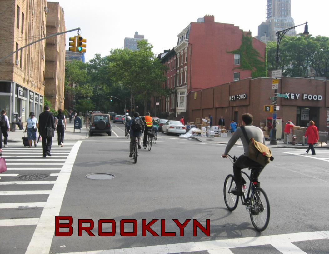
Brooklyn
SAFE STREETS NYC ��
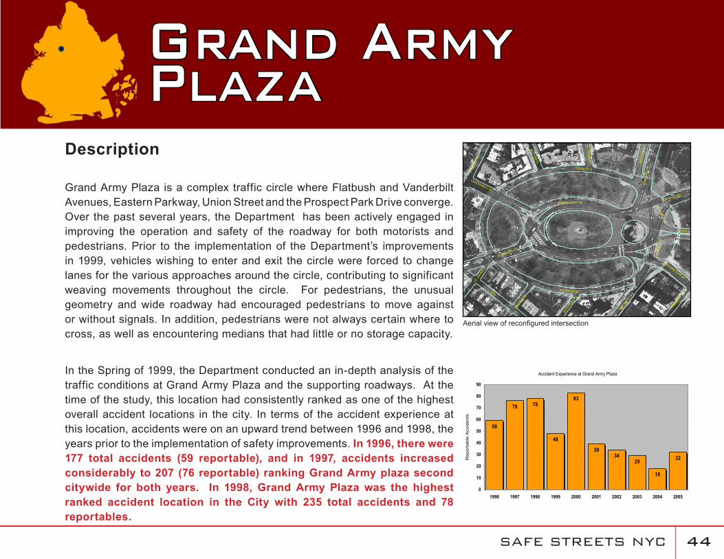
Description
Grand Army Plaza is a complex traffic circle where Flatbush and Vanderbilt Avenues, Eastern Parkway, Union Street and the Prospect Park Drive converge. Over the past several years, the Department has been actively engaged in improving the operation and safety of the roadway for both motorists and pedestrians. Prior to the implementation of the Department’s improvements in 1999, vehicles wishing to enter and exit the circle were forced to change lanes for the various approaches around the circle, contributing to significant weaving movements throughout the circle. For pedestrians, the unusual geometry and wide roadway had encouraged pedestrians to move against or without signals. In addition, pedestrians were not always certain where to cross, as well as encountering medians that had little or no storage capacity.
In the Spring of 1999, the Department conducted an in-depth analysis of the traffic conditions at Grand Army Plaza and the supporting roadways. At the time of the study, this location had consistently ranked as one of the highest overall accident locations in the city. In terms of the accident experience at this location, accidents were on an upward trend between 1996 and 1998, the years prior to the implementation of safety improvements. In 1996, there were 177 total accidents (59 reportable), and in 1997, accidents increased considerably to 207 (76 reportable) ranking Grand Army plaza second citywide for both years. In 1998, Grand Army Plaza was the highest ranked accident location in the City with 235 total accidents and 78 reportables.
Grand ArmyPlaza
8 AV
PLAZA ST E
PLAZA ST W
UNION
ST
EAST
ERN
PY
FLATBUSH AV
GRAND ARMY PZ
VANDERBILT AV
STER
LING
PL
LINCOLN
PL
STJO
HNSPL
BUTLER
PL
PRESID
ENT
ST
PROSPECT PK W
BERKE
LEY
PL
STJO
HN
SP
L
FLATBUSH AV
EAST
ERN
PY
WEST DR
PLAZAST
W
PLA
ZAS
TW
Accident Experience at Grand Army Plaza
39
83
48
3429
18
32
7876
59
0
10
20
30
40
50
60
70
80
90
1996 1997 1998 1999 2000 2001 2002 2003 2004 2005
Rep
orta
ble
Acc
iden
ts
Aerial view of reconfigured intersection
SAFE STREETS NYC ��
In 1999 and 2000, the Department implemented several measures aimed at improving vehicular and pedestrian safety throughout Grand Army Plaza. As such, the accident experience at this location improved substantially, with the number of reportable accidents at this location sharply decreasing by 38% (to 48 from 78) since the previous year. By 2001, this location had dropped to tenth citywide among high accident locations. After a spike in reportable accidents in 2000 (83 accidents) the numbers steadily declined each year between 2001 and 2004 and reached an all time low of only 18 in 2004, a 78% decrease since the peak in 2000. Although accidents increased slightly to 32 in 2005, this still represents a 61% decrease since 2000. Despite the overall decline in accidents, Grand Army Plaza was still ranked as the fourth highest reportable accident location citywide in 2002 and third in 2003 and 2005.
In addition to the decline in accidents, pedestrian conditions within the Plaza have also improved. Between 1996 and 2001, there was one pedestrian accident in each of these years with the exception of 1997, when four pedestrian accidents occurred.
Based upon the consistent improvement in the accident experience at this location after the implementation of improvements in 1999, the Department has concluded that the measures implemented at this location have had a profound impact on improving the safety of both motorists and pedestrians. In addition, this location can serve as an example of the overall improvement in safety throughout the city. Although this location was ranked in the top five citywide in 2002, 2003 and 2005, the number of reportable accidents at this location has declined by 38% since 1999. In addition, the trends in the rankings were influenced by the overall downward trend in accidents citywide.
SAFE STREETS NYC ��
Improvements Implemented in August 1999 and December 2000
Through signal adjustments, separated the Prospect Park exit from the northbound Flatbush Avenue movement.
Through new markings and signal adjustments, modified stopping points and clearance phases to eliminate conflict between southbound Flatbush Avenue and Union Street.
Split the pedestrian crossing of Flatbush Avenue (from the park to the library). Pedestrians are now able to cross from the park to the center median during the Flatbush Avenue north movement, from the library to the center median during the Eastern Parkway movement, and have a continuous crossing during the Prospect Park movement.
Installed a new crosswalk facilitating pedestrian access to the monument. The pedestrian signals between the traffic island and the monument were modified to display “WALK” when the southbound traffic is stopped.Modified the push button actuated signal (on the inner roadway at the north end of the plaza) to flash amber instead of steady green. This was coordinated with the installation of Yield signs and word messages where the inner roadway merges with traffic from southbound Flatbush Avenue/Vanderbilt Avenue.Improved roadway geometry by modifying and refurbishing pavement markings including channelization, skip lines, lane usage arrows, painted shoulders, buffer zones, reflective lane markers, and a ‘bus only’ lane for southbound traffic on the west side of the Plaza.Installed 20 signs (12 on mast arms) in advance of and around the Plaza. These are directional signs to properly guide motorists, reduce conflicts and minimize weaving movements. The locations of these signs are shown in the illustration to the right.Installed 12 o’clock green arrows for southbound traffic destined for Prospect Park West.
•
•
•
•
•
•
•
•
New Ground/Pole Mounted Signs
SAFE STREETS NYC �7
Installed a signal controlling southbound Flatbush Avenue at the north side of the Plaza to eliminate the conflicts with Vanderbilt Avenue and protect pedestrians.
Improvements Implemented in 2002 and 2003
All markings were refurbished in May 2002.
Modified the signal at the northern end of Grand Army Plaza to enhance pedestrian safety. The new operation provides a split crossing of Vanderbilt Avenue using the traffic island as a safety refuge. Pedestrians no longer have to negotiate the lengthy 120 foot crossing during the Flatbush Avenue [south] phase of the signal cycle. In addition the time to cross Flatbush Avenue was increased by approximately six seconds. This improvement was completed in August 2003.
The raised concrete island separating Flatbush Avenue (north & south) and Eastern Parkway was upgraded in September 2003. This improvement provides additional refuge space for pedestrians when crossing Flatbush Avenue. At times during the signal cycle, pedestrians may only cross half way and must wait before completing their crossing of Flatbush Avenue.
A street lighting upgrade consisting of the elements listed below was completed in November 2003:
16 new pedestrian arms equipped with 150 watt high pressure sodium luminaries were installed on existing street light poles on the perimeter.
Two new street light poles were installed on the roadway at the inner circle.
Two shaft extensions each equipped with two 250 watt high pressure sodium luminaires were installed on existing traffic signal poles near the entrance to Prospect Park.
Improvements Implemented in 2004
School crosswalks were refurbished in June and July 2004.
•
•
•
•
•
•
•
•
•
SAFE STREETS NYC ��
Over the past several years, the Department has been actively engaged in improving the safety and operability of numerous roadways in the northwest section of central Brooklyn. Some of the more notable roadways and intersections that have been a part of these efforts include the Eastern Parkway and Utica Avenue corridors, the intersection of Eastern Parkway and Utica Avenue itself and the intersection of Kings Highway, Linden Boulevard and Remsen Avenue. Many of the recommendations and subsequent improvements are the result of the early action plan of the Weeksville/Utica Avenue Transportation Study. This study involved working closely with other agencies (e.g. Department of City Planning, MTA), community groups, elected officials and other interested parties to develop solutions to address pedestrian safety and mobility concerns, as well as quality of life issues. Over the course of this study, the Department was able to implement many of the short-term mitigation measures (highlighted within this section) prior to the completion of the Final Report. In the spring of 2005, the Department completed the Study and its assessment of future traffic conditions (to 2010). As part of the Final Report, the Department developed a multi-faceted improvement package to improve the overall operation and safety for all users of the corridors within the study area. Many of these recommendations built upon efforts that were previously implemented in earlier phases of the study.
To date, the Department has focused on two primary areas of concern:
the Eastern Parkway corridor, the intersection of Eastern Parkway and Utica Avenue and the surrounding areas and
the intersection of Kings Highway, Linden Boulevard and Remsen Avenue and the surrounding areas.
•
•
Improvements in the Vicinity of Eastern Parkway/Utica Avenue & Kings Highway/Linden Boulevard/Remsen Avenue
SAFE STREETS NYC ��
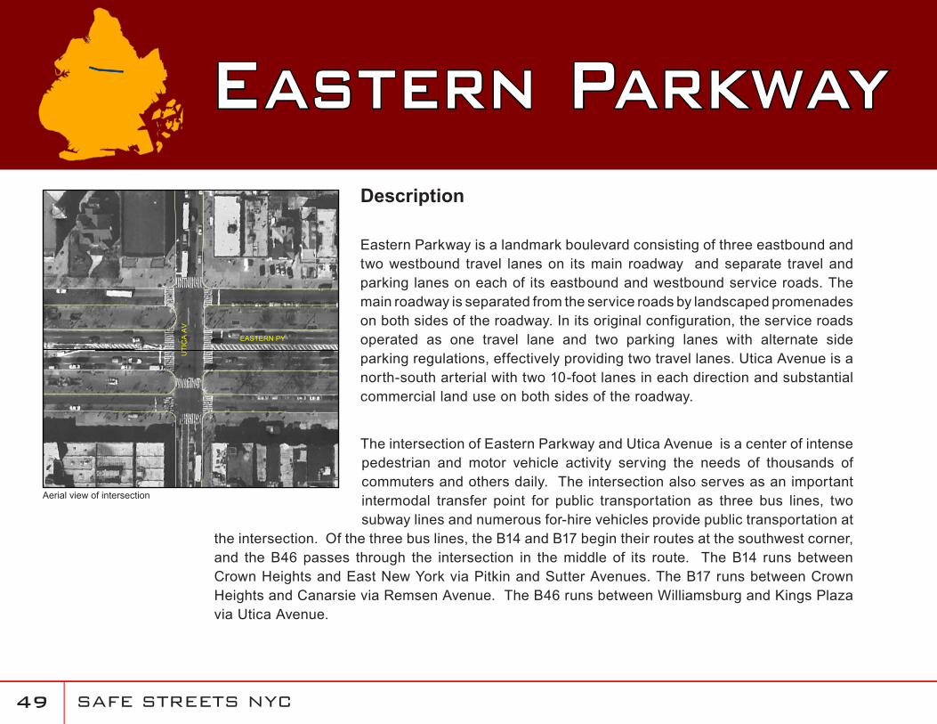
Eastern ParkwayDescription
Eastern Parkway is a landmark boulevard consisting of three eastbound and two westbound travel lanes on its main roadway and separate travel and parking lanes on each of its eastbound and westbound service roads. The main roadway is separated from the service roads by landscaped promenades on both sides of the roadway. In its original configuration, the service roads operated as one travel lane and two parking lanes with alternate side parking regulations, effectively providing two travel lanes. Utica Avenue is a north-south arterial with two 10-foot lanes in each direction and substantial commercial land use on both sides of the roadway.
The intersection of Eastern Parkway and Utica Avenue is a center of intense pedestrian and motor vehicle activity serving the needs of thousands of commuters and others daily. The intersection also serves as an important intermodal transfer point for public transportation as three bus lines, two subway lines and numerous for-hire vehicles provide public transportation at
the intersection. Of the three bus lines, the B14 and B17 begin their routes at the southwest corner, and the B46 passes through the intersection in the middle of its route. The B14 runs between Crown Heights and East New York via Pitkin and Sutter Avenues. The B17 runs between Crown Heights and Canarsie via Remsen Avenue. The B46 runs between Williamsburg and Kings Plaza via Utica Avenue.
UTI
CA
AV
EASTERN PY
Aerial view of intersection
SAFE STREETS NYC �0
Eastern Parkway Two subway routes, the “3” and “4” stop at Utica Avenue. The “3” is a local that continues east to New Lots Avenue and the “4” is a heavily patronized express that terminates at Utica Avenue. This makes the intersection very active as commuters transfer between the subway and other transit modes to continue their journies. The subway station entrances are located on the promenade.
With the high volume of buses, for-hire vehicles and pedestrians, this intersection, especially along the eastbound service road of Eastern Parkway and Utica Avenue is often congested. In addition, the illegal use of bus stops by for-hire vehicles that do not comply with existing parking regulations and traffic control devices is problematic. These vehicles routinely stop to pick up or drop off fares in the bus stops located on the eastbound service road and on both sides of Utica Avenue. This leads to significant congestion during the evening peak hours.
An additional concern at this location is illegal turns by for-hire vehicles from the eastbound service road onto Utica Avenue. Right turns onto Utica Avenue are prohibited for all vehicles except buses, and left turns onto Utica Avenue are prohibited for all vehicles. For-hire vehicles also make illegal U-turns on Utica Avenue. These illegal movements contribute to the congestion and safety concerns for both pedestrians and motorists.
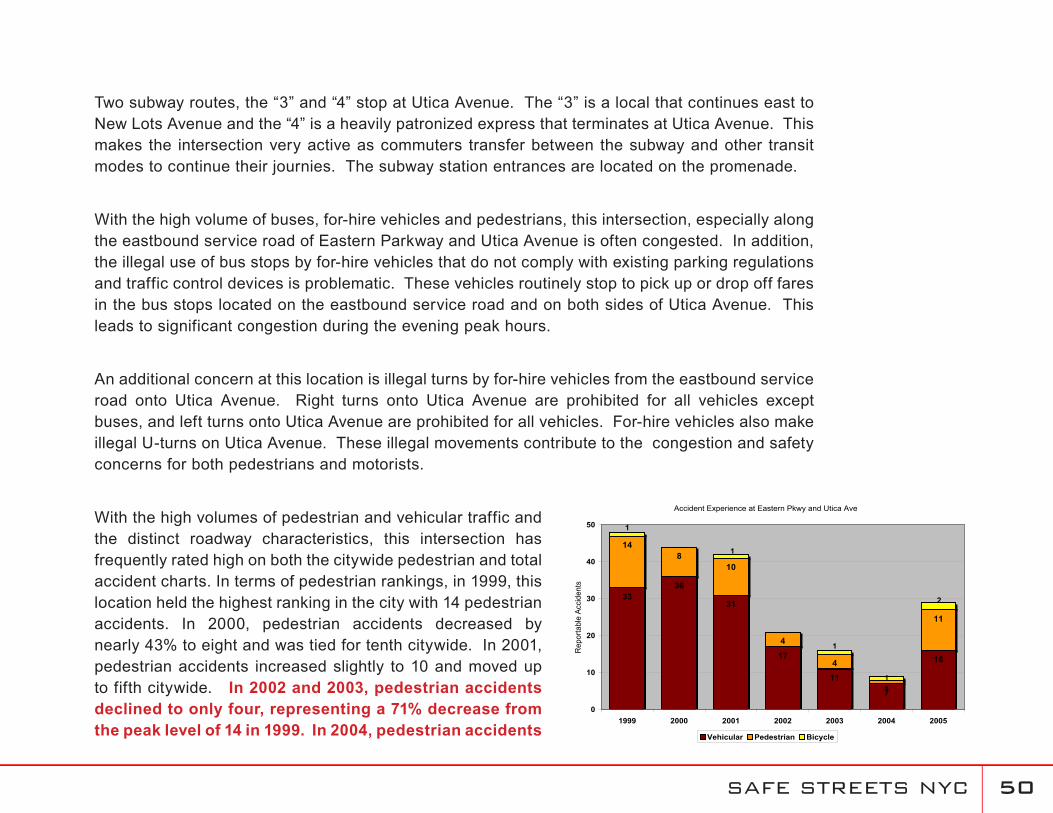
With the high volumes of pedestrian and vehicular traffic and the distinct roadway characteristics, this intersection has frequently rated high on both the citywide pedestrian and total accident charts. In terms of pedestrian rankings, in 1999, this location held the highest ranking in the city with 14 pedestrian accidents. In 2000, pedestrian accidents decreased by nearly 43% to eight and was tied for tenth citywide. In 2001, pedestrian accidents increased slightly to 10 and moved up to fifth citywide. In 2002 and 2003, pedestrian accidents declined to only four, representing a 71% decrease from the peak level of 14 in 1999. In 2004, pedestrian accidents
Accident Experience at Eastern Pkwy and Utica Ave
3336
31
17
11
7
16
148
10
4
4
1
11
1
1
1
1
2
0
10
20
30
40
50
1999 2000 2001 2002 2003 2004 2005
Rep
orta
ble
Acci
dent
s
Vehicular Pedestrian Bicycle
SAFE STREETS NYC �1
represented an all time low of one, a 93% decrease from 1999. Before improvements were completed, from 1999 to 2001, there was an average of 10.7 pedestrian accidents per year. After improvements were implemented, from 2003 to 2005, pedestrian accidents decreased by half to an average of 5.3 per year. There have been no fatalities at this intersection since 1998.
In June 1999, the Department began to implement several improvements to address identified concerns at this location. Although accidents peaked in 1999 wtih 48 reportable accidents, the accident experience since these measures were implemented has been encouraging. In 2000, reportable accidents decreased 8% to 44 accidents. Most encouraging about this decline was the 43% decline in pedestrian accidents (to eight in 2000 from 14 in 1999). In 2001, reportable accidents continued to decline to 42. After improvements began to be implemented in 2001, reportable accidents fell to 21, 16 and eight in 2002, 2003 and 2004, respectively. This represents a decline of 81% since the peak in 1999. Since improvements were made, the average number of accidents per year decreased by 60% to an average of 5.3 from 2003 through 2005 from an average of 10.6 from 1999 through 2001.
The Department believes that the series of improvements that began in 1999 have significantly improved safety at this location and along both corridors by providing for safer vehicular and pedestrian movements through the intersection, as well as improving the overall flow of traffic through these corridors. In addition, these trends parallel the overall improvements taking place citywide over this time period. The Department will continue to monitor the improvements at this intersection and expects that the future improvements resulting from the Weeksville/Utica Avenue Transportation Study will continue this downward trend in accidents at this location.
SAFE STREETS NYC �2
Improvements Implemented in June 1999
Prohibition of right and left turns from the eastbound service road to Utica Avenue
Periodic enforcement efforts against vehicles making illegal turns
Prohibition of left turn (and removal of left-turn lane) from the westbound main roadway of Eastern Parkway to southbound Utica Avenue
Addition of a westbound left-turn phase and lengthening of left-turn lane at the intersection of Eastern Parkway and Schenectady Avenue
Relocation of STOP bar for northbound Utica Avenue and installation of new signal display at the STOP bar in advance of the intersection
Installation of bus lanes on north and southbound Utica Avenue between Eastern Parkway and Union Street, effective Monday through Friday 7AM- 7PM
Installation of signs (regulatory, advisory, warning)
Refurbishment of all signs and markings
Improvements Implemented in 2001 and 2002
Since 2001, the Department has continued to focus upon improving conditions at this specific intersection while expanding its attention to other intersections along both the Eastern Parkway and Utica Avenue corridors. The most significant improvements are highlighted below:
At nine locations on Eastern Parkway (Classon Avenue, Franklin Avenue, Rogers Avenue, Nostrand Avenue, New York Avenue, Brooklyn Avenue, Albany Avenue, Troy Avenue, Schenectady Avenue), the signal operation was modified by stopping the service roads approximately 15 seconds before the mainline as a pedestrian safety enhancement. These signal improvements were implemented in April 2001 at the intersections of Eastern Parkway at
•
•
•
•
•
•
•
•
•
SAFE STREETS NYC ��
Nostrand Avenue and at Franklin Avenue, which are subway station locations that generate high volumes of pedestrians. Signal improvements at the remaining seven locations were completed in May 2001.
In conjunction with the signal modifications, parking regulations were changed from alternate day, alternate side “No Parking 8AM - 6PM” to standard 1½ hour street sweeping regulations. This allows parking on both sides of the service roads, which tends to lower the incidence of speeding. This work was completed in May 2001.
Extended the B46 southbound bus stop to the full length of the block between Eastern Parkway and Union Street to reduce conflicts with buses and vans. This work was completed in May 2001.
Extended the bus stop/layover location for the B14 and B17 routes on the south curb of Eastern Parkway between Utica and Schenectady Avenues from 169 to 224 feet to allow the buses to pull up closer to the curb and make pedestrian movements safer. The work was completed in June 2001.
Extended the existing priority bus lanes on both the east and west curbs of Utica Avenue between Eastern Parkway and Union Street to Carroll Street. In conjunction with this change,
“No Standing 7-10 AM/4-7 PM Except Sunday” and “No Standing Except Trucks Loading and Unloading 10AM-4PM Except Sunday” regulations were installed on both the east and west sides of Utica Avenue between Union and Carroll Streets. This work involved the removal of all meters between Union Street and Carroll Street. This work was completed in July 2001.
The centerline of Utica Avenue between Carroll Street and Empire Boulevard was offset to provide two travel lanes and one parking lane in each direction. This work was completed in July 2001.
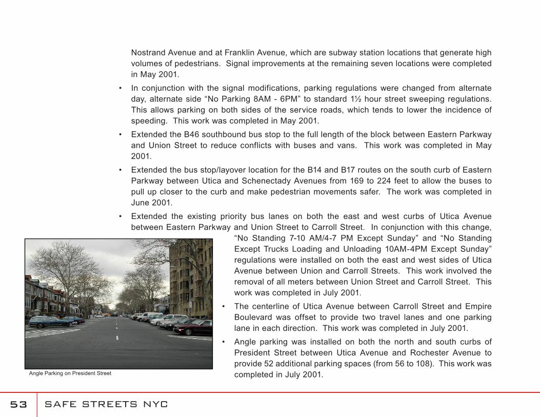
Angle parking was installed on both the north and south curbs of President Street between Utica Avenue and Rochester Avenue to provide 52 additional parking spaces (from 56 to 108). This work was completed in July 2001.
•
•
•
•
•
•
Angle Parking on President Street
SAFE STREETS NYC ��
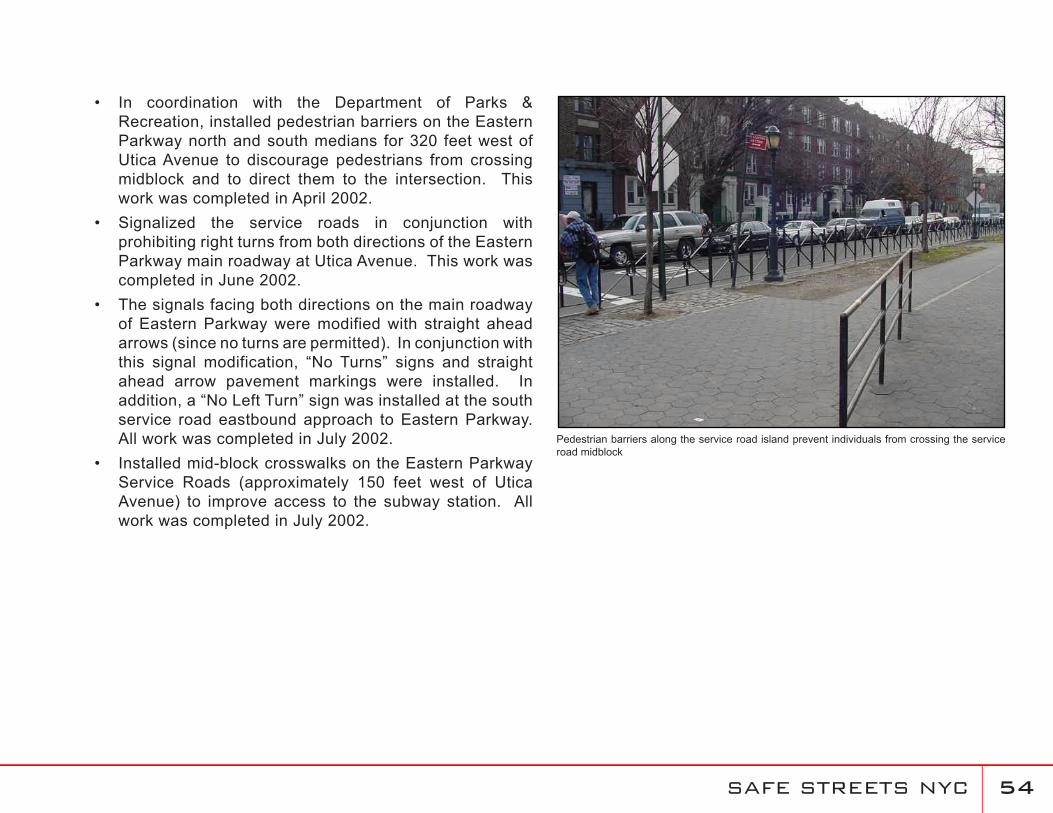
In coordination with the Department of Parks & Recreation, installed pedestrian barriers on the Eastern Parkway north and south medians for 320 feet west of Utica Avenue to discourage pedestrians from crossing midblock and to direct them to the intersection. This work was completed in April 2002.Signalized the service roads in conjunction with prohibiting right turns from both directions of the Eastern Parkway main roadway at Utica Avenue. This work was completed in June 2002.The signals facing both directions on the main roadway of Eastern Parkway were modified with straight ahead arrows (since no turns are permitted). In conjunction with this signal modification, “No Turns” signs and straight ahead arrow pavement markings were installed. In addition, a “No Left Turn” sign was installed at the south service road eastbound approach to Eastern Parkway. All work was completed in July 2002.Installed mid-block crosswalks on the Eastern Parkway Service Roads (approximately 150 feet west of Utica Avenue) to improve access to the subway station. All work was completed in July 2002.
•
•
•
•Pedestrian barriers along the service road island prevent individuals from crossing the service road midblock
SAFE STREETS NYC ��
Improvements Implemented in 2003
All markings on Utica Avenue were refurbished in April 2003.
To enhance pedestrian safety at the intersection of Utica Avenue and Avenue M, a Leading Pedestrian Interval (LPI) was added to the signal during Summer 2003. This allows pedestrians to start their crossing of Utica Avenue approximately six seconds prior to Avenue M getting a green indication.
Due to the wide configuration of Eastern Parkway and the difficulty in viewing street names at corners, oversized street name signs were suspended over the roadway at the following 16 intersections in September 2003:
Eastern Parkway @ Atlantic Avenue
Eastern Parkway @ Rockaway Avenue
Eastern Parkway @ Howard Avenue
Eastern Parkway @ Rochester Avenue
Eastern Parkway @ Schenectady Avenue
Eastern Parkway @ Troy Avenue
Eastern Parkway @ Albany Avenue
Eastern Parkway @ Kingston Avenue
Eastern Parkway @ Brooklyn Avenue
Eastern Parkway @ New York Avenue
Eastern Parkway @ Nostrand Avenue
Eastern Parkway @ Rogers Avenue
Eastern Parkway @ Fulton Street
Eastern Parkway @ Franklin Avenue
Eastern Parkway @ Bedford Avenue
Eastern Parkway @ Washington Avenue (Installed August 2003)
•
•
•
•
•
•
•
•
•
•
•
•
•
•
•
•
•
•
•
SAFE STREETS NYC ��
Improvements Implemented in October 2005
Intersection of Utica Avenue and Eastern Parkway
Installed Advanced Solid-State Traffic Controllers (ASTCs) along Utica Avenue between Pacific and Montgomery Streets.
Added a clearance interval for the southbound approach on Utica Avenue and installed 12 inch lenses on all signals.
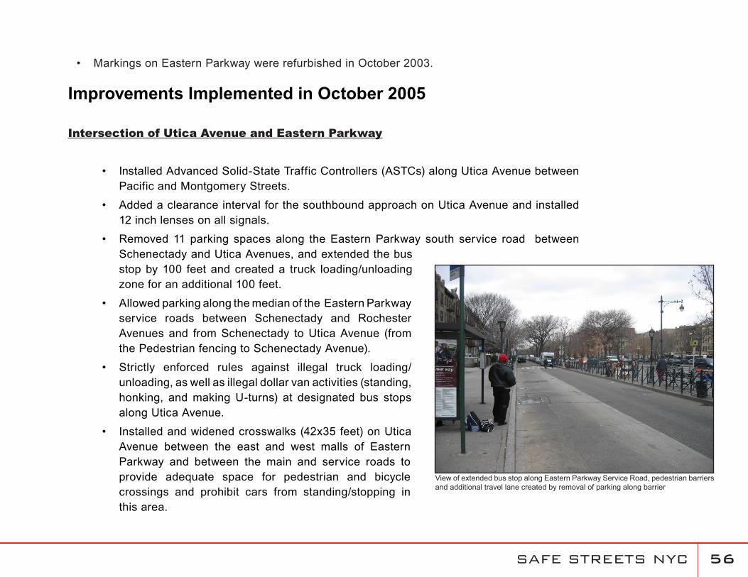
Removed 11 parking spaces along the Eastern Parkway south service road between Schenectady and Utica Avenues, and extended the bus stop by 100 feet and created a truck loading/unloading zone for an additional 100 feet.
Allowed parking along the median of the Eastern Parkway service roads between Schenectady and Rochester Avenues and from Schenectady to Utica Avenue (from the Pedestrian fencing to Schenectady Avenue).
Strictly enforced rules against illegal truck loading/unloading, as well as illegal dollar van activities (standing, honking, and making U-turns) at designated bus stops along Utica Avenue.
Installed and widened crosswalks (42x35 feet) on Utica Avenue between the east and west malls of Eastern Parkway and between the main and service roads to provide adequate space for pedestrian and bicycle crossings and prohibit cars from standing/stopping in this area.
•
•
•
•
•
•
View of extended bus stop along Eastern Parkway Service Road, pedestrian barriers and additional travel lane created by removal of parking along barrier
Markings on Eastern Parkway were refurbished in October 2003.•
SAFE STREETS NYC �7
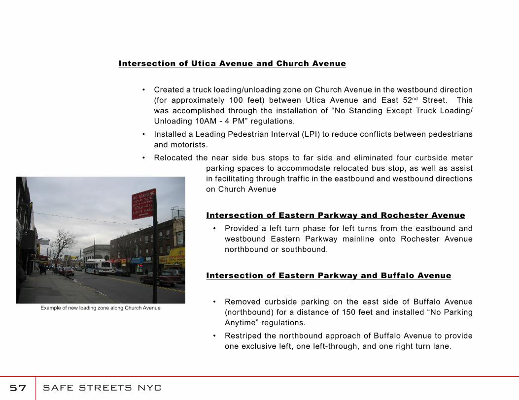
Intersection of Utica Avenue and Church Avenue
Created a truck loading/unloading zone on Church Avenue in the westbound direction (for approximately 100 feet) between Utica Avenue and East 52nd Street. This was accomplished through the installation of “No Standing Except Truck Loading/Unloading 10AM - 4 PM” regulations.
Installed a Leading Pedestrian Interval (LPI) to reduce conflicts between pedestrians and motorists.
Relocated the near side bus stops to far side and eliminated four curbside meter parking spaces to accommodate relocated bus stop, as well as assist in facilitating through traffic in the eastbound and westbound directions on Church Avenue
Intersection of Eastern Parkway and Rochester AvenueProvided a left turn phase for left turns from the eastbound and westbound Eastern Parkway mainline onto Rochester Avenue northbound or southbound.
Intersection of Eastern Parkway and Buffalo Avenue
Removed curbside parking on the east side of Buffalo Avenue (northbound) for a distance of 150 feet and installed “No Parking Anytime” regulations.
Restriped the northbound approach of Buffalo Avenue to provide one exclusive left, one left-through, and one right turn lane.
•
•
•
•
•
•
Example of new loading zone along Church Avenue
SAFE STREETS NYC ��
Intersection of President Street and Utica Avenue
Created a truck loading/unloading zone on President Street west of Utica Avenue for approximately 100 feet and installed “No Standing Except Truck Loading/Unloading 10AM to 4 PM” regulations.
Intersection of Fulton Street and Utica Avenue
Installed “No Standing Anytime” regulations for approximately 50 feet from the intersection in the westbound and northbound approaches (north and east corners).
Refurbished all lane markings and installed high visibility crosswalks to improve safety for vehicular and pedestrian traffic.
Relocated near side bus stop.
Intersection of Eastern Parkway and Howard AvenueReallocated three and five seconds of green time from the northbound/southbound phase to the eastbound/westbound phase during the AM and PM peak hours, respectively.
•
•
•
•
•
SAFE STREETS NYC ��
Improvements implemented in Spring 2006
Intersection of Utica Avenue and Eastern Parkway
Refurbished high visibility crosswalks at all approaches to clearly designate the proper path for pedestrians to safely cross the intersection.Installed “Wide Turn Zone” markings on the southwest corner of Utica Avenue at the Eastern Parkway south service road from the crosswalk to the stop bar. Installed a barricade for a distance of 38 feet on the east curb of Utica Avenue for the ‘Wide Turn Zone’ to protect pedestrian crossings.
Intersection of Utica Avenue and Church Avenue
Installed neckdowns at the northeast and southwest corners of Utica Avenue to increase effective sidewalk width and decrease crossing distance for pedestrians. Widened all pedestrian crosswalks from 14 to 18 feet and refurbished all lane markings.
Intersection of Eastern Parkway and Rochester Avenue
Removed curbside parking on the east side of Rochester Avenue (northbound) for a distance of 100 feet from the Eastern Parkway south service road and installed “No Parking 7-10 AM and 4-7 PM” regulations.
•
•
•
•
•
SAFE STREETS NYC �0
Description
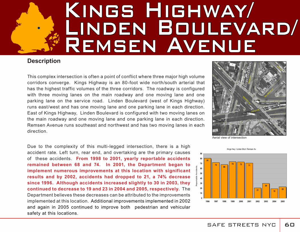
This complex intersection is often a point of conflict where three major high volume corridors converge. Kings Highway is an 80-foot wide north/south arterial that has the highest traffic volumes of the three corridors. The roadway is configured with three moving lanes on the main roadway and one moving lane and one parking lane on the service road. Linden Boulevard (west of Kings Highway) runs east/west and has one moving lane and one parking lane in each direction. East of Kings Highway, Linden Boulevard is configured with two moving lanes on the main roadway and one moving lane and one parking lane in each direction. Remsen Avenue runs southeast and northwest and has two moving lanes in each direction.
Due to the complexity of this multi-legged intersection, there is a high accident rate. Left turn, rear end, and overtaking are the primary causes of these accidents. From 1998 to 2001, yearly reportable accidents remained between 68 and 74. In 2001, the Department began to implement numerous improvements at this location with significant results and by 2002, accidents had dropped to 21, a 74% decrease since 1996. Although accidents increased slightly to 30 in 2003, they continued to decrease to 19 and 23 in 2004 and 2005, respectively. The Department believes these decreases can be attributed to the improvements implemented at this location. Additional improvements implemented in 2002 and again in 2005 continued to improve both pedestrian and vehicular safety at this locations.
Kings Highway/Linden Boulevard/Remsen Avenue
REMSENAV
KIN
GS
HY
LINDEN BL
WILLMOHR
ST
E91 ST
Kings Hwy / Linden Blvd / Remsen Av
81
7268
74 73 71
21
30
1923
0
10
20
30
40
50
60
70
80
90
1996 1997 1998 1999 2000 2001 2002 2003 2004 2005
Re
po
rta
ble
Acc
ide
nts
!P
Aerial view of intersection
SAFE STREETS NYC �1
Implemented Improvements
In September 2000, a left turn signal phase was installed for westbound Linden Boulevard to southbound Kings Highway, and the timing was modified at the Linden Boulevard/East 58th Street intersection to improve coordination for westbound Linden Boulevard.
In July 2001, most of the crossings controlled by pedestrian signals were upgraded to high visibility crosswalk markings.
In June 2001, the All-Red clearance (at the end of the Remsen Avenue phase) was extended to six seconds to clear the movement from southbound Remsen Avenue to eastbound Linden Boulevard.
In June 2001, “No Standing 7-10AM Monday-Friday” regulations were installed on the east curb of Remsen Avenue between Kings Highway and East 58th Street.
In August 2001, 19 oversized street names signs (42” x 18”) were installed for Linden Boulevard (seven), Kings Highway (six), and Remsen Avenue (six).
In October 2001, “No Parking Anytime” signs were installed on both curbs of Linden Boulevard between Kings Highway and East 58th Street to maintain two moving lanes.
In October 2001, a trailblazer sign was installed on westbound Linden Boulevard (between East 92nd and 93rd Streets) directing motorists destined to northbound Kings Highway to use the service road.
In November 2001, the length of the near side bus stop was extended (by approximately 100 feet) on southbound Remsen Avenue at Kings Highway and the bus stop between Lenox Road and East 55th Street was eliminated to better accommodate the two bus lines (B17, B78).
In November 2001, the northbound Remsen Avenue far side bus stop was relocated approximately 60 feet downstream to eliminate spillback at the intersection.
Kings Highway was repaved by DDC in 2001.
Left turns from southbound Kings Highway to Linden Boulevard and Remsen Avenue were
•
•
•
•
•
•
•
•
•
•
•
SAFE STREETS NYC �2
prohibited. In coordination with this turn restriction, a left-turn signal phase (for Kings Highway) was installed at Church Avenue to enable motorists to access southbound Remsen or Ralph Avenues. The existing left turn bay at Kings Highway was modified to a flush painted median in order to provide a pedestrian refuge. Median markings were extended north to East 92nd Street to eliminate the lane merge in advance of the intersection. The southbound left turn bay on Kings Highway at Church Avenue was extended to 180 feet from 100 feet. Additionally, three trailblazer signs were installed: 1) to Linden Boulevard (12 o’clock arrow) at Remsen and Church Avenues, 2) to Remsen Avenue/Linden Boulevard (12 o’clock arrow) at Ralph and Church Avenues and 3) to Ralph Avenue/Remsen Avenue/Linden Boulevard (9 o’clock arrow) at Kings Highway. All work was completed in March 2002.
A left turn signal phase was installed for southbound Remsen Avenue to eastbound Linden Boulevard. A new signal pole was installed on the southwest corner (of Linden Boulevard and Remsen Avenue) to improve the visibility of the signals for southbound Remsen Avenue motorists. To accommodate the additional turning phase, an ASTC was installed. The cycle length remained at 120 seconds in peak periods but was increased from 90 to 120 seconds during all off-peak periods. In coordination with this left-turn signal phase, through and left pavement arrows were installed on southbound Remsen Avenue prior to eastbound Linden Boulevard. Most pavement marking modifications were completed in November 2001 and some further enhancements were completed in January 2002. The signal work was completed in March 2002.
The westbound Linden Boulevard main road (east of the intersection) was restriped to provide an additional moving lane (from three to four). Additionally, two lanes were designated for Remsen Avenue and two lanes for Linden Boulevard (previously, only one lane was designated for Remsen Avenue and two lanes for Linden Boulevard), and five signs were installed (four overhead, one ground-mounted) directing motorists to appropriate lanes. Mast arm poles were installed to support overhead lane assignment signs. All signal work was completed in March 2002. Most pavement marking modifications were installed in November 2001 with some further enhancements completed in January 2002.
Cycle lengths on adjacent signals on both Kings Highway and Linden Boulevard were increased
•
•
•
SAFE STREETS NYC ��
from 90 to 120 seconds (during off-peak hours) to maintain coordination. All work was completed in March 2002.
A new signal timing plan was installed at Remsen and Ralph Avenues (discontinuing the previous fixed time operation) for improved coordination. All work was completed in March 2002.
Additional pedestrian signals were installed to better designate the Linden Boulevard crossing (east of Remsen Avenue). All work was completed in March 2002.
Selected signals (facing north and east) at Linden Boulevard and Kings Highway were louvered to minimize confusion. All work was completed in March 2002.
The following short-term bus stop improvement measures were implemented in coordination with New York City Transit in June 2002:
Moved the northbound B7 bus stop from the near side of the main road to the far side of the service road to provide additional storage for through vehicles (southbound stop remained near side).
Relocated the main road near side bus stops (both directions) at Church Avenue to the service road on the far side of the intersection.
Improvements Implemented in October 2005
As part of the Utica/Weeksville Transportation Study, the following improvements were implemented in October 2005:
•
•
•
•
•
SAFE STREETS NYC ��
Intersection of Kings Highway, Remsen Avenue and Linden Boulevard
Prohibited the following left turns from Kings Highway, Linden Boulevard, and Remsen Avenue:
Northbound from Kings Highway onto Linden Boulevard/Remsen Avenue westbound.
Eastbound from Linden Boulevard onto Kings Highway/Remsen Avenue northbound.
Northbound from Remsen Avenue onto Linden Boulevard/Kings Highway westbound and southbound.
Reallocated signal timing to account for implementation of turning restrictions.
Relocated B7 bus from the Kings Highway main roadways to the service roads from Snyder Avenue (slip ramps) to the Lenox Road/Kings Highway intersection.
Relocated bus stop at southwest corner of Remsen Avenue and Linden Boulevard (northbound) by moving it back 95 feet.
Refurbished high visibility crosswalks at all approaches to clearly designate the proper path for pedestrians to safely cross the intersection.
Installed markings on Linden Boulevard from Kings Highway to Bedford Avenue to create center medians with left turn bays.
Removed street sweeping parking regulations on the north curb of Linden Boulevard between East 58 th and East 56 th Streets during the morning and evening rush hours and installed “No Standing 7-10AM & 4-7PM” regulations
•
•
•
•
•
•
•
•
•
•
New markings and signage were installed to improve safety and operation of the intersection
No Standing regulations during the peak periods provide for additional lane capacity
SAFE STREETS NYC ��
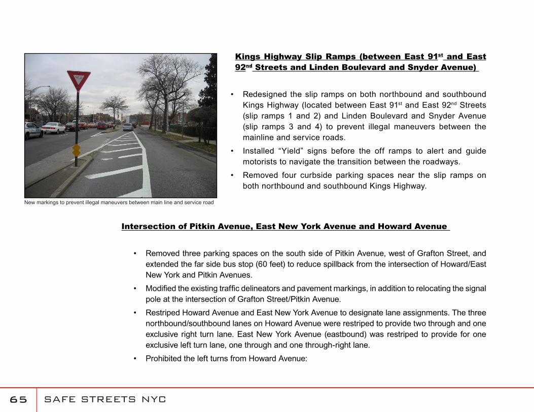
Kings Highway Slip Ramps (between East 91st and East 92nd Streets and Linden Boulevard and Snyder Avenue)
Redesigned the slip ramps on both northbound and southbound Kings Highway (located between East 91st and East 92nd Streets (slip ramps 1 and 2) and Linden Boulevard and Snyder Avenue (slip ramps 3 and 4) to prevent illegal maneuvers between the mainline and service roads.
Installed “Yield” signs before the off ramps to alert and guide motorists to navigate the transition between the roadways.
Removed four curbside parking spaces near the slip ramps on both northbound and southbound Kings Highway.
Intersection of Pitkin Avenue, East New York Avenue and Howard Avenue
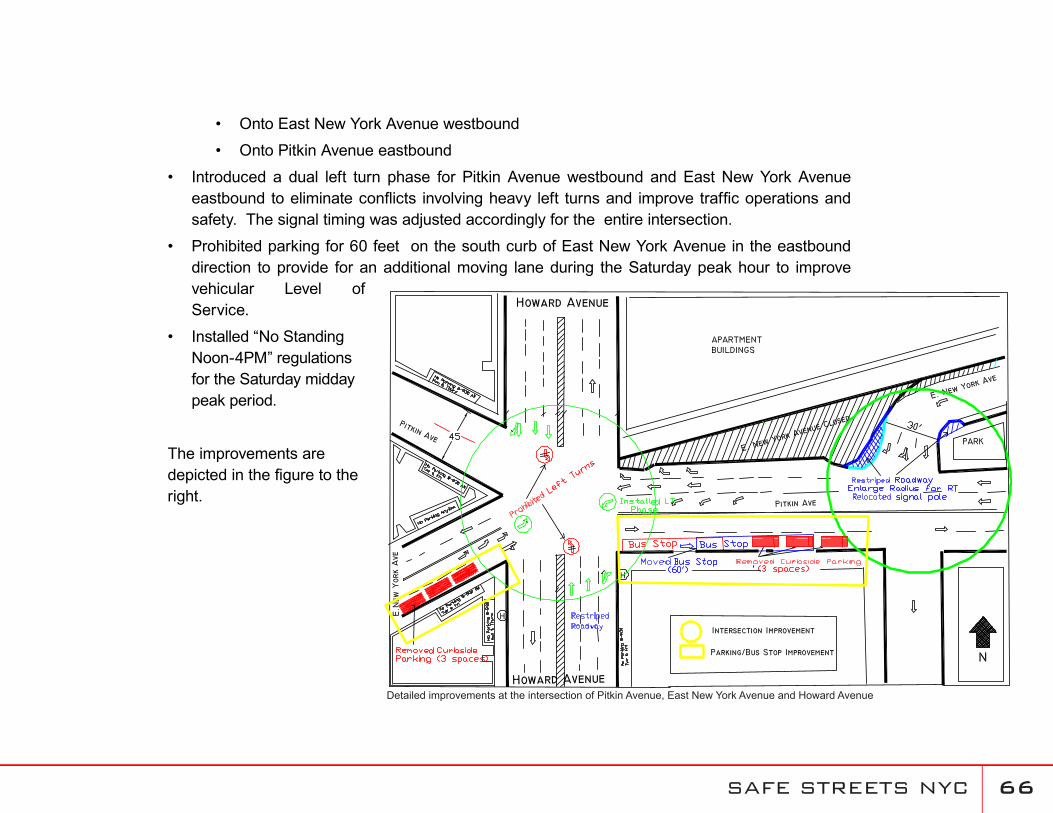
Removed three parking spaces on the south side of Pitkin Avenue, west of Grafton Street, and extended the far side bus stop (60 feet) to reduce spillback from the intersection of Howard/East New York and Pitkin Avenues.
Modified the existing traffic delineators and pavement markings, in addition to relocating the signal pole at the intersection of Grafton Street/Pitkin Avenue.
Restriped Howard Avenue and East New York Avenue to designate lane assignments. The three northbound/southbound lanes on Howard Avenue were restriped to provide two through and one exclusive right turn lane. East New York Avenue (eastbound) was restriped to provide for one exclusive left turn lane, one through and one through-right lane.
Prohibited the left turns from Howard Avenue:
•
•
•
•
•
•
•
New markings to prevent illegal maneuvers between main line and service road
SAFE STREETS NYC ��
Onto East New York Avenue westbound
Onto Pitkin Avenue eastbound
Introduced a dual left turn phase for Pitkin Avenue westbound and East New York Avenue eastbound to eliminate conflicts involving heavy left turns and improve traffic operations and safety. The signal timing was adjusted accordingly for the entire intersection.
Prohibited parking for 60 feet on the south curb of East New York Avenue in the eastbound direction to provide for an additional moving lane during the Saturday peak hour to improve vehicular Level of Service.
Installed “No Standing Noon-4PM” regulations for the Saturday midday peak period.
The improvements are depicted in the figure to the right.
•
•
•
•
•
Detailed improvements at the intersection of Pitkin Avenue, East New York Avenue and Howard Avenue
SAFE STREETS NYC �7
Intersection of East New York Avenue and Utica Avenue
Removed three parking spaces on the west side of Utica Avenue.
Restricted curbside parking on the east side of Remsen Avenue (seven parking spaces) at the East New York and Utica Avenue intersection to provide three moving lanes (left, left/through, and right turn lane) for northbound Remsen Avenue traffic. Installed “No Standing 7 AM to 10 AM” regulations.
Synchronized traffic signals along Utica Avenue between Empire Boulevard and East New York Avenue.
Replaced parallel parking with angle parking (90 degree) along East New York Avenue
Howard Avenue and Tapscott Street/Blake Avenue Interchange
Refurbished all lane markings and crosswalks and installed advisory signs along Tapscott Street/Howard Avenue between Rutland Avenue and East 98th Street to alert motorists of the existing roadway curvature and merge with Howard Avenue.
Intersection of Kings Highway and Church Avenue
Removed curbside parking (100 feet) along Church Avenue and restriped roadway for two moving lanes (11 feet each) in the eastbound and westbound directions. Installed “No Standing 7-10 AM” regulations.
•
•
•
•
•
•
SAFE STREETS NYC ��
Intersection of Kings Highway and Rockaway Parkway
Reallocated three seconds of green time from the northbound/southbound phase to the eastbound/westbound phase during both the AM and PM peak hours.
Intersectionof Ralph Avenue and Fulton/McDougal Streets
Removed curbside parking (100 feet) along Ralph Avenue and installed “No Standing 7 AM to 7 PM Except Sunday” regulations.
•
•
SAFE STREETS NYC ��
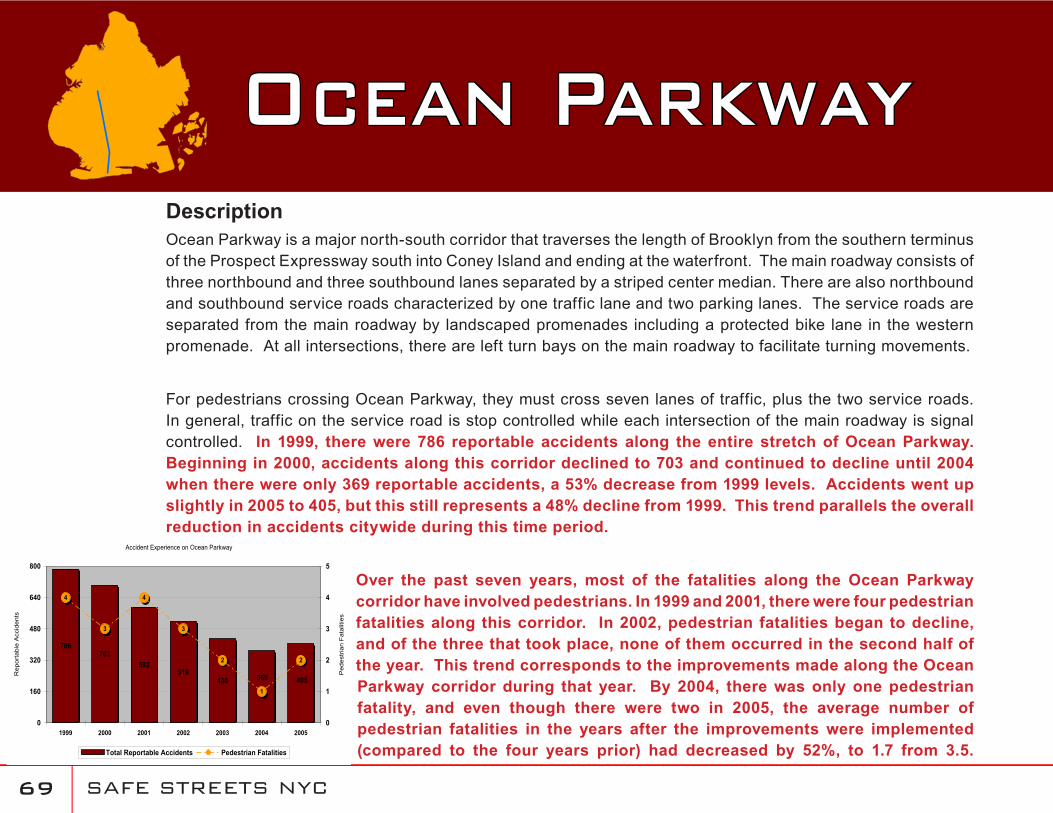
DescriptionOcean Parkway is a major north-south corridor that traverses the length of Brooklyn from the southern terminus of the Prospect Expressway south into Coney Island and ending at the waterfront. The main roadway consists of three northbound and three southbound lanes separated by a striped center median. There are also northbound and southbound service roads characterized by one traffic lane and two parking lanes. The service roads are separated from the main roadway by landscaped promenades including a protected bike lane in the western promenade. At all intersections, there are left turn bays on the main roadway to facilitate turning movements.
For pedestrians crossing Ocean Parkway, they must cross seven lanes of traffic, plus the two service roads. In general, traffic on the service road is stop controlled while each intersection of the main roadway is signal controlled. In 1999, there were 786 reportable accidents along the entire stretch of Ocean Parkway. Beginning in 2000, accidents along this corridor declined to 703 and continued to decline until 2004 when there were only 369 reportable accidents, a 53% decrease from 1999 levels. Accidents went up slightly in 2005 to 405, but this still represents a 48% decline from 1999. This trend parallels the overall reduction in accidents citywide during this time period.
Over the past seven years, most of the fatalities along the Ocean Parkway corridor have involved pedestrians. In 1999 and 2001, there were four pedestrian fatalities along this corridor. In 2002, pedestrian fatalities began to decline, and of the three that took place, none of them occurred in the second half of the year. This trend corresponds to the improvements made along the Ocean Parkway corridor during that year. By 2004, there was only one pedestrian fatality, and even though there were two in 2005, the average number of pedestrian fatalities in the years after the improvements were implemented (compared to the four years prior) had decreased by 52%, to 1.7 from 3.5.
Ocean Parkway
Accident Experience on Ocean Parkway
786703
592519
430 369 405
4
3
4
3
2
1
2
0
160
320
480
640
800
1999 2000 2001 2002 2003 2004 2005
Rep
orta
ble
Acc
iden
ts
0
1
2
3
4
5
Ped
estr
ian
Fat
aliti
es
Total Reportable Accidents Pedestrian Fatalities
SAFE STREETS NYC 70
Ocean Parkway There were no fatalities along this corridor in 2006.
Implemented Improvements
In order to improve pedestrian safety and increase crossing time, the cycle length of all off-peak timing patterns was increased from 90 to 120 seconds in January 2002. As a result, the crossing time for Ocean Parkway was increased at all 34 signalized locations (from Church to Sea Breeze Avenues). Most of the intersections provided an additional 12 seconds of crossing time while others provided an additional six to 17 seconds.
Of the 34 intersections along Ocean Parkway, 16 had left-turn signal phases prior to 2002. In January 2002, it was determined that left turn signal phases would be added to the remaining 18 intersections. As of April 2002, work was completed at 16 of the 18 intersections. The last two intersections were completed in May 2002. Each intersection along the corridor now has left a turn signal phase.
In February 2002, a contract was initiated to replace all vehicle signals with LED displays and all pedestrian signals with international LED displays. Ocean Parkway was the first corridor completed (in March 2002) under this contract.
Markings on Ocean Parkway were refurbished in May 2003.
In April 2003, URS consultants completed a study on behalf of the Department to evaluate traffic conditions on Ocean Parkway between Church Avenue and Avenue J. The purpose of the study was to analyze both the existing traffic signal operation which utilized “protected/permitted” left turn phases and an alternative “protected only” mode.
Their short term recommendation was to maintain existing signal timing and phasing with the exception of Ocean Parkway and Parkville Avenue where they suggested that the existing left turn phase be switched from a leading to a lagging operation. DOT implemented this recommendation in July 2003. Their long term recommendation was to optimize the existing “permitted/protected” operation by modifying signal splits and offsets. This recommendation is not being implemented because it would require reductions in the time currently allocated for pedestrian crossings at several locations.
•
•
•
•

SAFE STREETS NYC 71
Aerial view of intersection
Description
This is a complex multi-legged intersection. Bushwick Avenue (runs east/west) approaches this intersection from the west and terminates, Pennsylvania Avenue (runs north/south) also ends at this intersection, Jamaica Avenue (runs east/west) becomes East New York Avenue two blocks west of the intersection, and the Jackie Robinson Parkway (runs north/south) has its southern terminus at this intersection.
There is a four phase signal operation at this location. During the first signal phase, motorists (predominantly buses) are permitted to make a left turn (almost a “V”-turn) from Pennsylvania Avenue onto westbound Jamaica Avenue. During the second signal phase, right and thru movements are permitted from northbound Pennsylvania Avenue. Motorists exiting the Jackie Robinson Parkway (southbound) can also move at this time. The third phase is exclusively for motorists westbound on Jamaica Avenue. The fourth phase is exclusively for eastbound Jamaica Avenue motorists.
Pennsylvania Avenue has three lane designations: an exclusive left turn lane, a thru/left turn lane, and a thru/right turn lane. Prohibited movements include: the left turn from eastbound Bushwick Avenue onto the Jackie Robinson Parkway; Jackie Robinson Parkway southbound motorists in the left two lanes can only proceed straight to Pennsylvania Avenue (no right or left turns are permitted). Previously, there were two sets of rumble strips on the southbound Jackie Robinson
Bushwick Avenue/East New York Avenue/Jackie Robinson Parkway
JAMAIC
A AV
BUSHWICK AV
MA
RG
INA
LST
W
JR
OBI
NSO
NPY
ETW
BJ
RO
BIN
SON
PYEN
EB
PENN
SYLVANIA
AV
SAFE STREETS NYC 72
Bushwick Avenue/East New York Avenue/Jackie Robinson Parkway
Parkway approach to the intersection. There is also channelization that designates lanes for motorists approaching westbound Jamaica Avenue and lanes approaching Pennsylvania Avenue. The width of the approach immediately before the channelization is 44 feet.
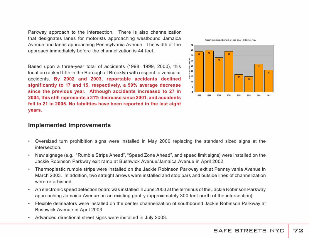
Based upon a three-year total of accidents (1998, 1999, 2000), this location ranked fifth in the Borough of Brooklyn with respect to vehicular accidents. By 2002 and 2003, reportable accidents declined significantly to 17 and 15, respectively, a 59% average decrease since the previous year. Although accidents increased to 27 in 2004, this still represents a 31% decrease since 2001, and accidents fell to 21 in 2005. No fatalities have been reported in the last eight years.
Implemented Improvements
Oversized turn prohibition signs were installed in May 2000 replacing the standard sized signs at the intersection.
New signage (e.g., “Rumble Strips Ahead”, “Speed Zone Ahead”, and speed limit signs) were installed on the Jackie Robinson Parkway exit ramp at Bushwick Avenue/Jamaica Avenue in April 2002.
Thermoplastic rumble strips were installed on the Jackie Robinson Parkway exit at Pennsylvania Avenue in March 2003. In addition, two straight arrows were installed and stop bars and outside lines of channelization were refurbished.
An electronic speed detection board was installed in June 2003 at the terminus of the Jackie Robinson Parkway approaching Jamaica Avenue on an existing gantry (approximately 300 feet north of the intersection).
Flexible delineators were installed on the center channelization of southbound Jackie Robinson Parkway at Bushwick Avenue in April 2003.
Advanced directional street signs were installed in July 2003.
•
•
•
•
•
•
Accident Experience at Bushwick Av - East NY Av - J. Robinson Pkwy
39 40
33
39
1715
27
21
0
5
10
15
20
25
30
35
40
45
1998 1999 2000 2001 2002 2003 2004 2005
Re
po
rta
ble
Accid
en
ts
SAFE STREETS NYC 7�
SAFE STREETS NYC 7�
SAFE STREETS NYC 7�
Description
In the spring of 2005, at the request of elected officials and in response to a fatality at the intersection of Gerritsen Avenue and Florence Avenue, the Department undertook a proactive corridor investigation to address community concerns along Gerritsen Avenue in southeast Brooklyn. Gerritsen Avenue runs from Nostrand Avenue to the north and terminates at a cul-de-sac near the Belt Parkway to the south. It functions as the primary access road into and out of the Gerritsen Beach community and is bordered for most of its length by parkland on the eastern curb and residential or low-density commercial land uses along the western curb. Along the southern portion of Gerritsen Avenue, it is the only north-south roadway in the Gerritsen Beach community.
In its original configuration, Gerritsen Avenue was characterized by its wide width, with two travel lanes and one parking lane in each direction. In addition, there were few stop controls along Gerritsen Avenue, with Stop signs regulating vehicles on the approaching streets. This configuration lead to issues of speeding and pedestrian safety along the entire corridor.
Based upon these roadway characteristics, the Department developed a traffic calming program to improve overall safety for motorists and pedestrians along the entire corridor. Comparisons between before and after speeds along Gerritsen Avenue indicate a significant reduction in speeds on all segments of the roadway. Overall, the daily average speed in the northbound direction declined by 9.9% to 28.6 mph from 31.6 mph. In the southbound direction, the daily average speed decreased by 11.9% to 26.9 mph from 30.5 mph. Certain portions of the corridor, such as from Devon Avenue to Florence Avenue, experienced more significant declines than the other sections, however all segments showed a remarkable decline in speed.
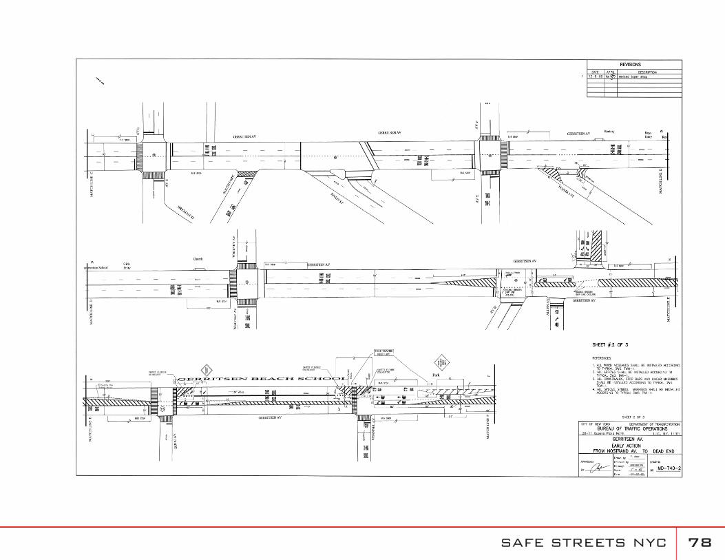
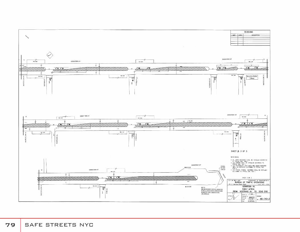
Gerritsen Avenue
SAFE STREETS NYC 7�
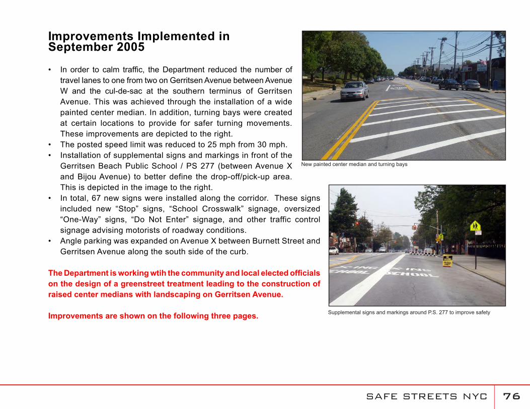
Gerritsen Avenue Improvements Implemented in September 2005
In order to calm traffic, the Department reduced the number of travel lanes to one from two on Gerritsen Avenue between Avenue W and the cul-de-sac at the southern terminus of Gerritsen Avenue. This was achieved through the installation of a wide painted center median. In addition, turning bays were created at certain locations to provide for safer turning movements. These improvements are depicted to the right.The posted speed limit was reduced to 25 mph from 30 mph. Installation of supplemental signs and markings in front of the Gerritsen Beach Public School / PS 277 (between Avenue X and Bijou Avenue) to better define the drop-off/pick-up area. This is depicted in the image to the right. In total, 67 new signs were installed along the corridor. These signs included new “Stop” signs, “School Crosswalk” signage, oversized “One-Way” signs, “Do Not Enter” signage, and other traffic control signage advising motorists of roadway conditions. Angle parking was expanded on Avenue X between Burnett Street and Gerritsen Avenue along the south side of the curb.
The Department is working wtih the community and local elected officials on the design of a greenstreet treatment leading to the construction of raised center medians with landscaping on Gerritsen Avenue.
Improvements are shown on the following three pages.
•
••
•
•
New painted center median and turning bays
Supplemental signs and markings around P.S. 277 to improve safety
SAFE STREETS NYC 77
SAFE STREETS NYC 7�
SAFE STREETS NYC 7�
SAFE STREETS NYC �0
Description
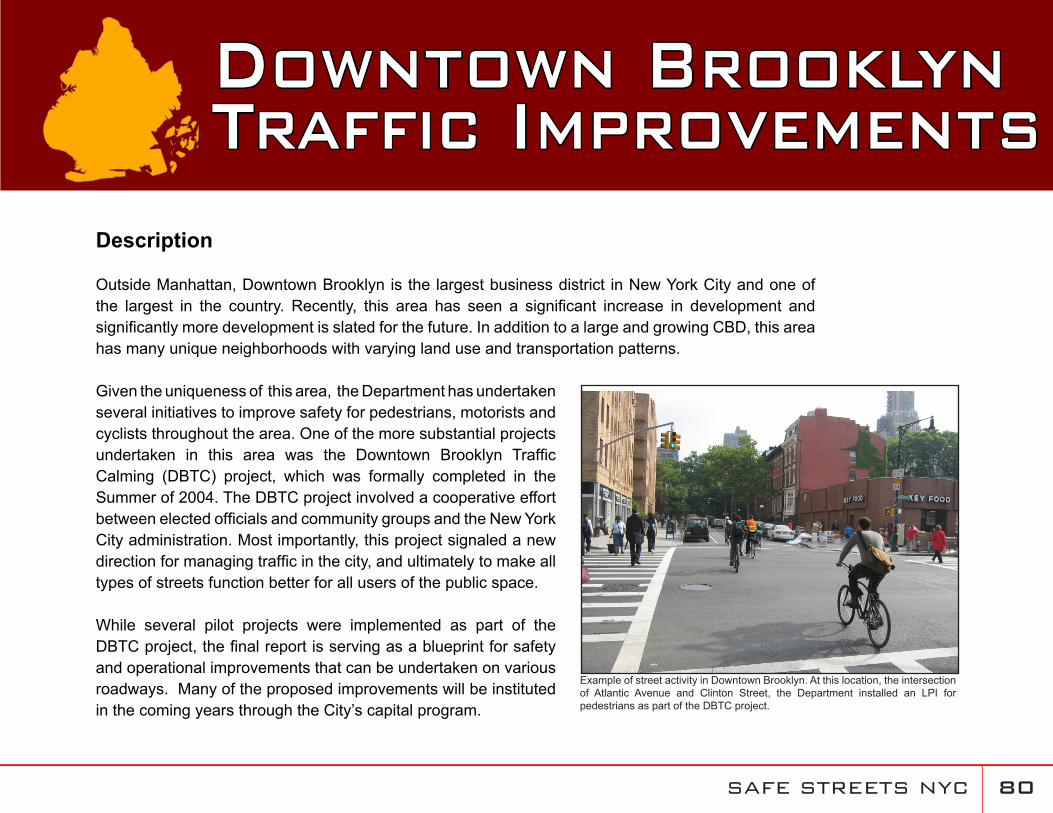
Outside Manhattan, Downtown Brooklyn is the largest business district in New York City and one of the largest in the country. Recently, this area has seen a significant increase in development and significantly more development is slated for the future. In addition to a large and growing CBD, this area has many unique neighborhoods with varying land use and transportation patterns.
Given the uniqueness of this area, the Department has undertaken several initiatives to improve safety for pedestrians, motorists and cyclists throughout the area. One of the more substantial projects undertaken in this area was the Downtown Brooklyn Traffic Calming (DBTC) project, which was formally completed in the Summer of 2004. The DBTC project involved a cooperative effort between elected officials and community groups and the New York City administration. Most importantly, this project signaled a new direction for managing traffic in the city, and ultimately to make all types of streets function better for all users of the public space.
While several pilot projects were implemented as part of the DBTC project, the final report is serving as a blueprint for safety and operational improvements that can be undertaken on various roadways. Many of the proposed improvements will be instituted in the coming years through the City’s capital program.
Downtown Brooklyn Traffic Improvements
Example of street activity in Downtown Brooklyn. At this location, the intersection of Atlantic Avenue and Clinton Street, the Department installed an LPI for pedestrians as part of the DBTC project.
SAFE STREETS NYC �1
More recently, the Department has pursued additional safety enhancement strategies in the Downtown Brooklyn area based upon the recommendations contained in the DBTC report, as well as instituting additional measures based upon demonstrated needs and experience. These include the following:
• Court Street Traffic Improvements• Improvements along the Smith Street Corridor • Safety Improvements along the Fulton Street Corridor
The following section details these improvements.
SAFE STREETS NYC �2
Description
During the DBTC project, local stakeholders in the community identified Court Street as a problematic corridor due to the perception of speeding and the high incidence of pedestrians crossing against the signals. The original timing patterns on Court Street used 120 second cycles to provide better coordination with the 120 second cycles being used on the heavily trafficked arteries of Atlantic and Hamilton Avenues. The use of the longer cycle lengths on Court Street (between Atlantic and Hamilton Avenues) led to the perception of speeding, provided fewer opportunities for pedestrians to cross Court Street and required pedestrians to wait longer to get the “walking man” indication.
Implemented Improvements
Beginning in the fall of 2004, the Department initiated a project to address these concerns. The primary objectives from the outset were to facilitate pedestrian crossings and discourage speeding.
In order to achieve the specified goals, the Department modified the signals to provide longer crossing times for pedestrians and more opportunities for pedestrians to cross Court Street between Atlantic and Hamilton Avenues. This was accomplished through the installation of ASTCs, reducing the cycle length from 120 to 90 seconds and changing the splits from 80 seconds for Court Street and 40 seconds for the side streets, to only 50 seconds for Court Street and 40 seconds for the side streets. In addition, the offsets were changed so the progression speed on Court Street would be approximately 20 mph.
Court Street
SAFE STREETS NYC ��
While the Department continues to monitor the timing scenarios on Court Street, a comparison between “before” conditions (prior to signal modifications) to “after” conditions found that:
More opportunities have been provided for pedestrians to cross Court Street;Overall, average traffic volumes decreased on Court Street during all weekday and weekend peak periods;There was no evidence of traffic diversion to Henry Street;Radar speed surveys indicate a reduction in speed on Court Street;Although travel times decreased, speeds remained within the 20 mph progression;Queue lengths on Court Street decreased indicating that volume was being efficiently processed with less green time; and Side street queues averaged one vehicle per cycle.
In October, 2005 we further reduced the cycle length to 60 seconds with splits of 35 seconds for Court Street and 25 seconds for the cross streets [with the exception of the signal at Court Street with Bergen and Congress Streets - this signal is three phase with a 25/17/18 split]. The progression speed of 20 mph was maintained.
••
••••
•
SAFE STREETS NYC ��
Description
Smith Street was identified as a problematic corridor during the DBTC Project. This corridor provides northbound connectivity through the same corridor in the morning peak period that southbound Court Street provides in the evening peak period. However, the conflicts between motorists and street users is not as pronounced as on Court Street because vehicular demand occurs primarily during the morning peak commuting period. Prior to the Department’s improvements along this corridor, Smith Street experienced substantial congestion on its approaches to Atlantic Avenue, due to the existing off-set configuration of the intersection. This configuration, where Smith Street operated two-way north of Atlantic Avenue, and one-way south of Atlantic Avenue, created a head-on situation.
Beginning in November 2003, the Department began to implement several changes in the operation of Smith Street, with the most notable change being the one-way conversion of Smith Street from two-way to one-way between Atlantic Avenue and Schermerhorn Street. Based upon NYPD Accident Data, at the intersection of Smith Street and Atlantic Avenue in the nearly six years (71 months) prior to the conversion, the corridor experienced approximately 32.6 accidents a year, with 16.9 annual injuries and approximately 4.7 pedestrians injured per year. In the two years (24 months) after implementation (December 2003 to December 2005), the annualized rate of accidents at this location fell to 19.5 annual accidents, with only 6.5 injuries per year, of which 1.9 were pedestrians. This represents a decline of 42% in the total number of annual accidents, with an even more remarkable decline of 62% in the number of injuries.
Smith Street!P
Vehicular conflicts at the intersection of Smith Street and Atlantic Avenue prior to improvements
SAFE STREETS NYC ��
Implemented Improvements
In November 2003, Smith Street was converted from a two-way to one-way northbound operation between Atlantic Avenue and Schermerhorn Street. In addition, back-in only parking was provided to narrow the roadway and normalize the approach at Schermerhorn Street. This measure reduced potential vehicles conflicts and improved the overall operation at the intersection of Smith Street and Atlantic Avenue. In addition, rush hour regulations were removed south of Atlantic Avenue to discourage “cut-through” traffic and provide more parking for residents. These improvements also required the rerouting of the B61 bus and are depicted below.
Detailed diagram of Smith Street improvements
SAFE STREETS NYC ��
Description
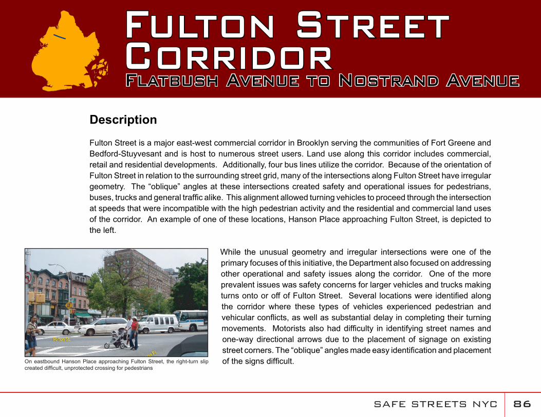
Fulton Street is a major east-west commercial corridor in Brooklyn serving the communities of Fort Greene and Bedford-Stuyvesant and is host to numerous street users. Land use along this corridor includes commercial, retail and residential developments. Additionally, four bus lines utilize the corridor. Because of the orientation of Fulton Street in relation to the surrounding street grid, many of the intersections along Fulton Street have irregular geometry. The “oblique” angles at these intersections created safety and operational issues for pedestrians, buses, trucks and general traffic alike. This alignment allowed turning vehicles to proceed through the intersection at speeds that were incompatible with the high pedestrian activity and the residential and commercial land uses of the corridor. An example of one of these locations, Hanson Place approaching Fulton Street, is depicted to the left.
While the unusual geometry and irregular intersections were one of the primary focuses of this initiative, the Department also focused on addressing other operational and safety issues along the corridor. One of the more prevalent issues was safety concerns for larger vehicles and trucks making turns onto or off of Fulton Street. Several locations were identified along the corridor where these types of vehicles experienced pedestrian and vehicular conflicts, as well as substantial delay in completing their turning movements. Motorists also had difficulty in identifying street names and one-way directional arrows due to the placement of signage on existing street corners. The “oblique” angles made easy identification and placement of the signs difficult.
Fulton StreetCorridor Flatbush Avenue to Nostrand Avenue
On eastbound Hanson Place approaching Fulton Street, the right-turn slip created difficult, unprotected crossing for pedestrians
SAFE STREETS NYC �7
In terms of the pedestrian environment, the Department found that many of the crosswalks along the Fulton Street corridor were not updated to current NYCDOT standards. The unusual “oblique” angles also presented challenges for pedestrians using the corridor.
Finally, Futlon Street functions as a major transit corridor, and at certain locations, such as at Flatbush Avenue, serves as a major transit hub. At this location, which connects directly to the Fulton Mall, up to five bus routes (B25, B26, B38, B44 and B52) operate on Fulton Street, with 42 scheduled buses per hour during the peak period. Prior to the implementation of improvements along this corridor, Fulton Street had designated bus lanes. Due to the high volume of traffic, the
geometric constraints of the roadway and lack of motorist compliance for the bus lanes, bus service typically incurred significant delays at all times of the day.
Implemented Improvements
A multi-faceted corridor-wide enhancement program was implemented that featured the following elements:
Gateway Treatments
In order to alleviate the safety and operational concerns at the intersections with “oblique” angles, the Department reconfigured three intersections to normal “right angle” corners. These locations include:
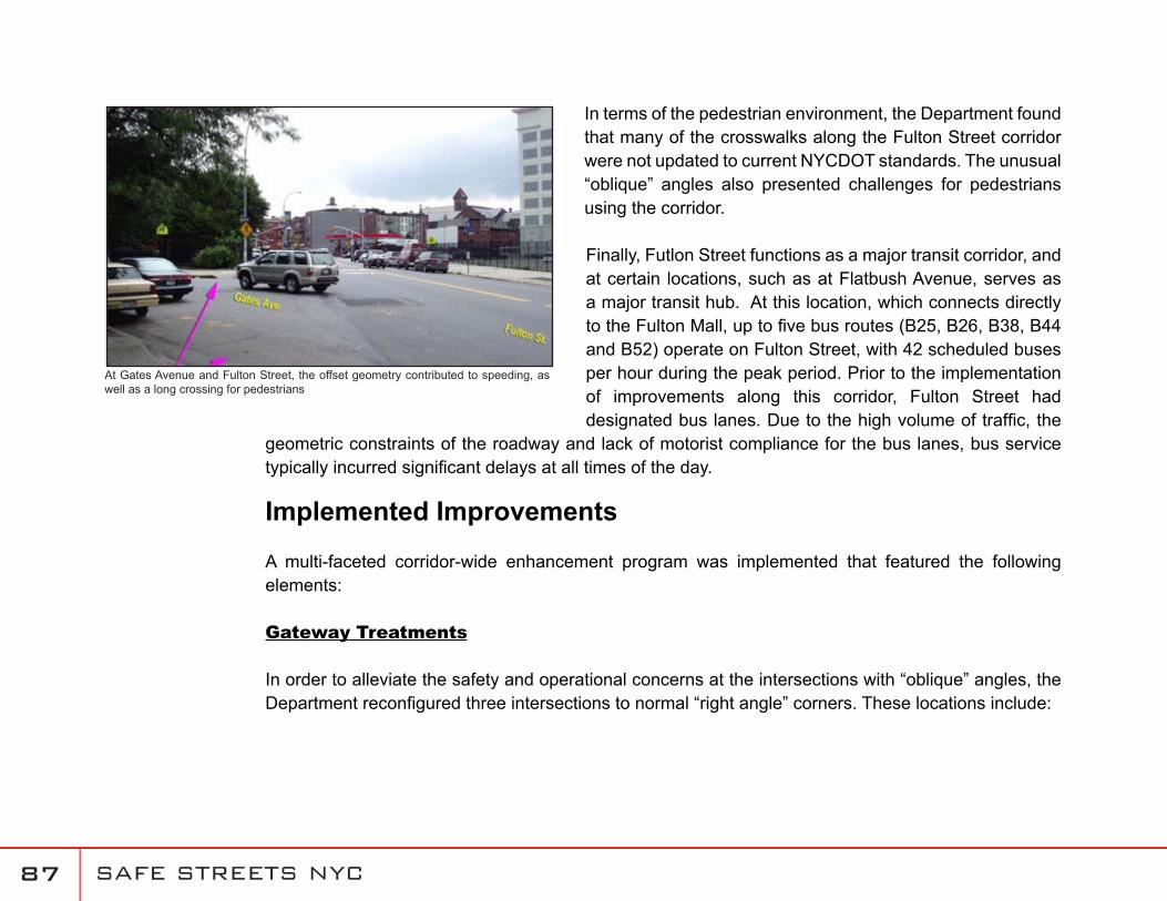
At Gates Avenue and Fulton Street, the offset geometry contributed to speeding, as well as a long crossing for pedestrians
SAFE STREETS NYC ��
Gateway treatment and street-direction conversion at Putnam Avenue and Fulton Street
Through the use of flexible bollards and markings, the Department normalized the intersection and significantly shortened the crossing distance across Gates Avenue
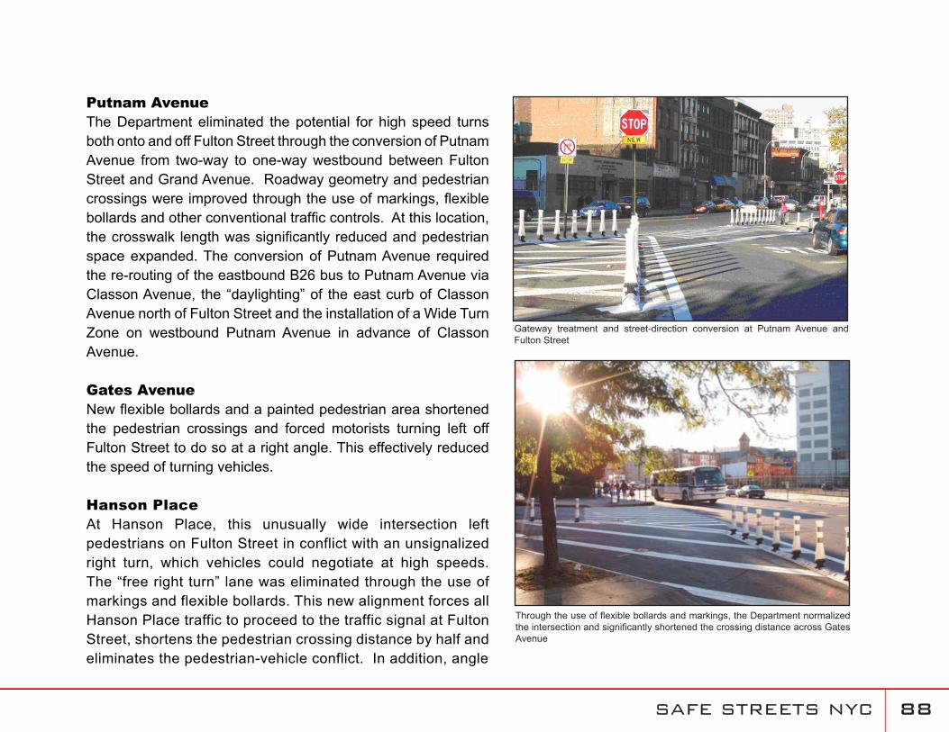
Putnam AvenueThe Department eliminated the potential for high speed turns both onto and off Fulton Street through the conversion of Putnam Avenue from two-way to one-way westbound between Fulton Street and Grand Avenue. Roadway geometry and pedestrian crossings were improved through the use of markings, flexible bollards and other conventional traffic controls. At this location, the crosswalk length was significantly reduced and pedestrian space expanded. The conversion of Putnam Avenue required the re-routing of the eastbound B26 bus to Putnam Avenue via Classon Avenue, the “daylighting” of the east curb of Classon Avenue north of Fulton Street and the installation of a Wide Turn Zone on westbound Putnam Avenue in advance of Classon Avenue.
Gates Avenue New flexible bollards and a painted pedestrian area shortened the pedestrian crossings and forced motorists turning left off Fulton Street to do so at a right angle. This effectively reduced the speed of turning vehicles.
Hanson PlaceAt Hanson Place, this unusually wide intersection left pedestrians on Fulton Street in conflict with an unsignalized right turn, which vehicles could negotiate at high speeds. The “free right turn” lane was eliminated through the use of markings and flexible bollards. This new alignment forces all Hanson Place traffic to proceed to the traffic signal at Fulton Street, shortens the pedestrian crossing distance by half and eliminates the pedestrian-vehicle conflict. In addition, angle
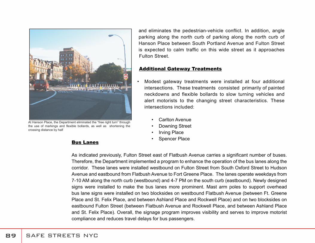
SAFE STREETS NYC ��
and eliminates the pedestrian-vehicle conflict. In addition, angle parking along the north curb of parking along the north curb of Hanson Place between South Portland Avenue and Fulton Street is expected to calm traffic on this wide street as it approaches Fulton Street.
Additional Gateway Treatments
Modest gateway treatments were installed at four additional intersections. These treatments consisted primarily of painted neckdowns and flexible bollards to slow turning vehicles and alert motorists to the changing street characteristics. These intersections included:
Carlton AvenueDowning StreetIrving PlaceSpencer Place
•
••••
At Hanson Place, the Department eliminated the “free right turn” through the use of markings and flexible bollards, as well as shortening the crossing distance by half
Bus Lanes
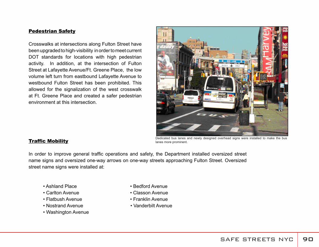
As indicated previously, Fulton Street east of Flatbush Avenue carries a significant number of buses. Therefore, the Department implemented a program to enhance the operation of the bus lanes along the corridor. These lanes were installed westbound on Fulton Street from South Oxford Street to Hudson Avenue and eastbound from Flatbush Avenue to Fort Greene Place. The lanes operate weekdays from 7-10 AM along the north curb (westbound) and 4-7 PM on the south curb (eastbound). Newly designed signs were installed to make the bus lanes more prominent. Mast arm poles to support overhead bus lane signs were installed on two blocksides on westbound Flatbush Avenue (between Ft. Greene Place and St. Felix Place, and between Ashland Place and Rockwell Place) and on two blocksides on eastbound Fulton Street (between Flatbush Avenue and Rockwell Place, and between Ashland Place and St. Felix Place). Overall, the signage program improves visibility and serves to improve motorist compliance and reduces travel delays for bus passengers.
SAFE STREETS NYC �0
Pedestrian Safety
Crosswalks at intersections along Fulton Street have been upgraded to high-visibility in order to meet current DOT standards for locations with high pedestrian activity. In addition, at the intersection of Fulton Street at Lafayette Avenue/Ft. Greene Place, the low volume left turn from eastbound Lafayette Avenue to westbound Fulton Street has been prohibited. This allowed for the signalization of the west crosswalk at Ft. Greene Place and created a safer pedestrian environment at this intersection.
Traffic Mobility
In order to improve general traffic operations and safety, the Department installed oversized street name signs and oversized one-way arrows on one-way streets approaching Fulton Street. Oversized street name signs were installed at:
• Ashland Place • Bedford Avenue • Carlton Avenue • Classon Avenue • Flatbush Avenue • Franklin Avenue • Nostrand Avenue • Vanderbilt Avenue• Washington Avenue
Dedicated bus lanes and newly designed overhead signs were installed to make the bus lanes more prominent.
SAFE STREETS NYC �1
Oversized one-way arrows have been installed at the following intersections:
• Adelphi Street • Carlton Avenue • Classon Street • Downing Street • Franklin Avenue • Grand Avenue • Hanson Place • Rockwell Place • Spencer Place • South Elliot Place • St. Felix Street • St. James Place • Waverly Avenue
Wide Turn Zones
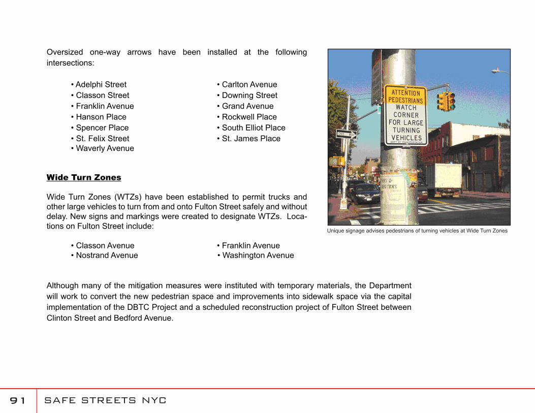
Wide Turn Zones (WTZs) have been established to permit trucks and other large vehicles to turn from and onto Fulton Street safely and without delay. New signs and markings were created to designate WTZs. Loca-tions on Fulton Street include:
• Classon Avenue • Franklin Avenue• Nostrand Avenue • Washington Avenue
Although many of the mitigation measures were instituted with temporary materials, the Department will work to convert the new pedestrian space and improvements into sidewalk space via the capital implementation of the DBTC Project and a scheduled reconstruction project of Fulton Street between Clinton Street and Bedford Avenue.
Unique signage advises pedestrians of turning vehicles at Wide Turn Zones
![Grief Resource List [rev 6.1.20] · Y a G o t P e o p l e : H e l p i n g P e o p l e w i t h D e v e l o p m e n ta l D is a b i li tie s D e a l w i t h G r ie f , B e r e a v e](https://img.pdfslide.us/doc/110x75/5f47875c717b3b07ff122afd/grief-resource-list-rev-6120-y-a-g-o-t-p-e-o-p-l-e-h-e-l-p-i-n-g-p-e-o-p-l.jpg)


![P H I L L I P S · s t e p h e n p h i l l i p s # #s 1;7 j/ s#8 ;];a ; p r o f e s s i o n a l p r o f i l e g ¯¹£ / ¯|ÊÀ ; Æp£;7p¼ Æ ª ;]](https://img.pdfslide.us/doc/110x75/5ffc8c8fbb3ab65b6c6d0e14/p-h-i-l-l-i-p-s-s-t-e-p-h-e-n-p-h-i-l-l-i-p-s-s-17-j-s8-a-p-r-o-f-e-s.jpg)


![Grief Resource List [rev 6.1.20] - rwjms.umdnj.edurwjms.umdnj.edu/departments_institutes/boggscenter/links/documen… · Y a G o t P e o p l e : H e l p i n g P e o p l e w i t h](https://img.pdfslide.us/doc/110x75/5f95c2d71360c973412fecd1/grief-resource-list-rev-6120-rwjmsumdnj-y-a-g-o-t-p-e-o-p-l-e-h-e-l-p.jpg)