Embed Size (px)
Citation preview
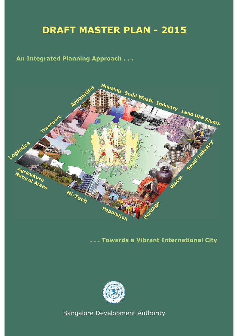
Bangalore Development Authority
. . . Towards a Vibrant International City
An Integrated Planning Approach . . .
Population Herita
ge
Sm
all Indust
ry
Housing
Agriculture
Natural Areas
Tran
sport
Industry
Slums
Solid Waste
Land Use
Wate
r
Hi-Tech
Logis
tics
Am
enitie
s
DRAFT MASTER PLAN - 2015

The first step towards planning for development in Bangalore was initiated with the Outline Development Plan (ODP), prepared by the Bangalore Development Committee. The Town and Country Planning Act, 1961, was enacted to enable preparation of development plans for settlements in Karnataka.
The Bangalore Development Authority (BDA) is entrusted with the task of preparing a Comprehensive Development Plan (CDP) as per the KTCP Act. The KTCP Act requires that the CDP be revised every 10 years. Consequently, BDA's mandate is to update the Revised CDP of 1995.
The Draft Master Plan - 2015, prepared under the KTCP Act, covers a Local Planning Area of 1306 sq. kms and consists of 387 villages, 7 City Municipal Councils (CMC) and 1 Town Municipal Council (TMC). It serves as the foundation for developing strategic plans and local area plans, and finally, designing neighbourhoods.
The Plan is powered by state-of-the-art technology consisting of an innovative and robust spatial data infrastructure at the metropolitan level. It comprises of a Geographical Information System (GIS), a Management Information System (MIS) and comprehensive data models enabling a plan that is up-to-date.
What does the Draft Master Plan comprise of?The Draft Master Plan contains sets of maps and documents in five volumes.
Volume 1 Master Plan Vision DocumentVolume 2 Existing Land Use Maps (for each Planning District)Volume 3 Proposed Land Use Maps (for each Planning District)Volume 4 Land Use Zonal RegulationsVolume 5 Planning Districts Report
As one of the world's f a s t e s t g r o w i n g
c i t ies, Bangalore is experiencing a steady increase in population (3.25% current annual g r o w t h r a t e ) . I t s population is likely to be 10 million by 2021. The growth is spurred by the advantages conferred on t h e C i t y b y en t repreneur ia l and
intellectual capacity incubated through a series of private and government actions. Besides, Bangalore enjoys a favourable climate, a high quality of life, a cosmopolitan ambience and social diversity. The City has earned the titles of “IT Hub of Asia” and “Silicon Valley of India.” However, while the IT based formal sector accounts for 15% of its economy, the informal sector contributes 60-70%.
Bangalore's advantages places it on the threshold of the status of an International City. A concerted effort towards developing new functions, especially high value service sectors, upgrading the City's infrastructure including transport, public amenities and logistics, and provision of housing options within the larger natural environment will contribute to the City's economic dynamism.
Issues and concerns facing Bangalore today
Like any growing city, Bangalore has its share of concerns that need immediate attention. Provision of housing, civic amenities and alternate modes of transportation, protection of natural areas and supply of adequate infrastructure facilities are some of the concerns.
Strategic planning with a focus on urban management, and a clear definition and coordination of institutional roles is essential.
Process Diagram
! 1952 - Bangalore Development Committee founded
! 1961 - Karnataka Town and Country Planning (KTCP) Act enacted
! 1963 - Outline Development Plan (ODP) submitted to Govt.
! 1965 - KTCP Act enforced
! 1972 - ODP approved and adopted under the KTCP Act 1961
! 1976 - BDA constitutedst! 1984 - 1 CDP for 1985 approvednd! 1995 - 2 CDP for 2005 approvedrd! 2005 - 3 CDP for 2015 prepared
Legend
Bangalore - An Emerging International City About the Draft Master Plan - 2015
Administrative areas map
Traffic and transport
Natural areas preservation
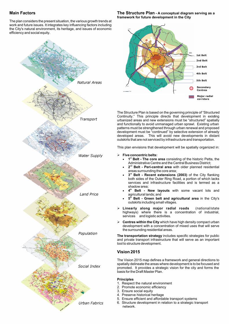
Main Factors
The plan considers the present situation, the various growth trends at work and future issues. It integrates key influencing factors including the City's natural environment, its heritage, and issues of economic efficiency and social equity.
The Structure Plan - A conceptual diagram serving as a framework for future development in the City
The Structure Plan is based on the governing principle of “Structured Continuity.” This principle directs that development in existing urbanized areas and new extensions must be “structured” spatially and functionally to avoid unmanaged urban sprawl. Existing urban patterns must be strengthened through urban renewal and proposed development must be “continued” by selective extension of already developed areas. This will avoid new developments in distant outskirts that are not serviced by infrastructure and transportation. This plan envisions that development will be spatially organized in:
Ø Five concentric belts:st
· 1 Belt - The core area consisting of the historic Petta, the Administrative Centre and the Central Business District;
nd· 2 Belt - Peri-central area with older planned residential
areas surrounding the core area;rd
· 3 Belt - Recent extensions (2003) of the City flanking both sides of the Outer Ring Road, a portion of which lacks services and infrastructure facilities and is termed as a shadow area;
th· 4 Belt - New layouts with some vacant lots and
agricultural lands; andth
· 5 Belt - Green belt and agricultural area in the City's outskirts including small villages.
Ø Linearly along major radial roads (national/state highways) where there is a concentration of industrial, services and logistic activities.
Ø Centres within the City which have high density compact urban development with a concentration of mixed uses that will serve the surrounding residential areas.
The transportation strategy includes specific strategies for public and private transport infrastructure that will serve as an important tool to structure development.
Vision 2015
The Vision 2015 map defines a framework and general directions to spatially delineate the areas where development is to be focused and promoted. It provides a strategic vision for the city and forms the basis for the Draft Master Plan.
Principles1. Respect the natural environment2. Promote economic efficiency3. Ensure social equity4. Preserve historical heritage5. Ensure efficient and affordable transport systems6. Structure development in relation to a strategic transport
network.
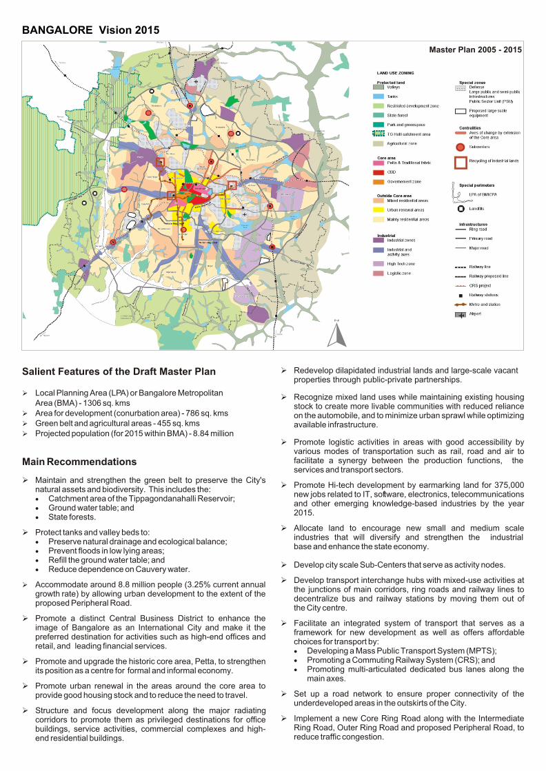
Ø Redevelop dilapidated industrial lands and large-scale vacant properties through public-private partnerships.
Ø Recognize mixed land uses while maintaining existing housing stock to create more livable communities with reduced reliance on the automobile, and to minimize urban sprawl while optimizing available infrastructure.
Ø Promote logistic activities in areas with good accessibility by various modes of transportation such as rail, road and air to facilitate a synergy between the production functions, the services and transport sectors.
Ø Promote Hi-tech development by earmarking land for 375,000 new jobs related to IT, software, electronics, telecommunications and other emerging knowledge-based industries by the year 2015.
Ø Allocate land to encourage new small and medium scale industries that will diversify and strengthen the industrial base and enhance the state economy.
Ø Develop city scale Sub-Centers that serve as activity nodes.
Ø Develop transport interchange hubs with mixed-use activities at the junctions of main corridors, ring roads and railway lines to decentralize bus and railway stations by moving them out of the City centre.
Ø Facilitate an integrated system of transport that serves as a framework for new development as well as offers affordable choices for transport by:· Developing a Mass Public Transport System (MPTS);· Promoting a Commuting Railway System (CRS); and· Promoting multi-articulated dedicated bus lanes along the
main axes.
Ø Set up a road network to ensure proper connectivity of the underdeveloped areas in the outskirts of the City.
Ø Implement a new Core Ring Road along with the Intermediate Ring Road, Outer Ring Road and proposed Peripheral Road, to reduce traffic congestion.
Salient Features of the Draft Master Plan
Ø Local Planning Area (LPA) or Bangalore Metropolitan Area (BMA) - 1306 sq. kms
Ø Area for development (conurbation area) - 786 sq. kmsØ Green belt and agricultural areas - 455 sq. kmsØ Projected population (for 2015 within BMA) - 8.84 million
Main Recommendations
Ø Maintain and strengthen the green belt to preserve the City's natural assets and biodiversity. This includes the:· Catchment area of the Tippagondanahalli Reservoir; · Ground water table; and· State forests.
Ø Protect tanks and valley beds to:· Preserve natural drainage and ecological balance;· Prevent floods in low lying areas;· Refill the ground water table; and· Reduce dependence on Cauvery water.
Ø Accommodate around 8.8 million people (3.25% current annual growth rate) by allowing urban development to the extent of the proposed Peripheral Road.
Ø Promote a distinct Central Business District to enhance the image of Bangalore as an International City and make it the preferred destination for activities such as high-end offices and retail, and leading financial services.
Ø Promote and upgrade the historic core area, Petta, to strengthen its position as a centre for formal and informal economy.
Ø Promote urban renewal in the areas around the core area to provide good housing stock and to reduce the need to travel.
Ø Structure and focus development along the major radiating corridors to promote them as privileged destinations for office buildings, service activities, commercial complexes and high-end residential buildings.
BANGALORE Vision 2015
Master Plan 2005 - 2015

16
Land Use Zones and Zonal Regulations
The Land Use Zonal Regulations for the Bangalore Local Planning Area (LPA) are prepared under Clause (iii) of Sub-section (2) of Section 12 and 21 of the Karnataka Town and Country Planning (KTCP) Act. Details are available in Volume 4 of the Draft Master Plan - 2015.
The Land Use and Developmental Zones of the Draft Master Plan are organized under three categories.
LAND USE ZONES
I
Main Areas Category
II
Specific Areas Category
III
Constraint Areas Category
I. Main Areas Category
The Main Areas Category consists of 16 zones each containing specific regulations and rules that apply to selected areas. The 16 zones are applied to five selected areas of the LPA based on their characteristics, urbanpattern and development potential.
II. Specific Areas Category
Areas within the LPA which have specific land uses that are not included under the Main Areas Category come under the Specific Areas Category. Development within these areas requires coordination and consultation with the concerned Authority or government body in order to comply with the larger framework of the Draft Master Plan - 2015.
1
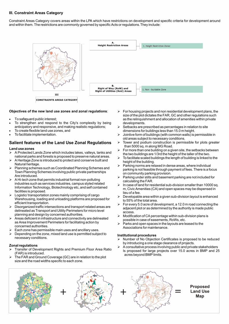
Objectives of the new land use zones and zonal regulations:
· To safeguard public interest;· To strengthen and respond to the City's complexity by being
anticipatory and responsive, and making realistic regulations;· To create flexible land use zones, and · To facilitate implementation.
Salient features of the Land Use Zonal Regulations
Land use zones Ø A Protected Lands Zone which includes lakes, valleys, tanks and
national parks and forests is proposed to preserve natural areas.Ø A Heritage Zone is introduced to protect and conserve built and
Natural heritage.Ø Planning schemes such as Coordinated Planning Schemes and
Town Planning Schemes involving public private partnershipsAre introduced.
Ø A Hi-tech zone that permits industrial format non-pollutingindustries such as services industries, campus styled related Information Technology, Biotechnology etc, and self contained facilities is proposed.
Ø Logistic/ transportation zones mainly comprising of cargoWarehousing, loading and unloading platforms are proposed for efficient transportation.
Ø Disorganized traffic intersections and transport related areas are delineated as Transport and Utility Perimeters for micro level planning and design by concerned authorities.
Ø Areas deficient in infrastructure and connectivity are delineated as Area Improvement Perimeters for facilitating action by concerned authorities.
Ø Each zone has permissible main uses and ancillary uses. Ø Depending on the zone, mixed land use is permitted subject to
necessary conditions.
Zonal regulations Ø Transfer of Development Rights and Premium Floor Area Ratio
(FAR) is introduced. Ø The FAR and Ground Coverage (GC) are in relation to the plot
size and the road widths specific to each zone.
Ø For housing projects and non residential development plans, the size of the plot dictates the FAR, GC and other regulations such as the relinquishment and allocation of amenities within private developments.
Ø Setbacks are prescribed as percentages in relation to site dimensions for buildings less than 15.0 m height.
Ø Jointive form of buildings (with common walls) is permissible inold areas subject to necessary conditions.
Ø Tower and podium construction is permissible for plots greaterthan 5000 sq. m along MG Road.
Ø For more than one building on a given site, the setbacks between the two buildings are 1/3rd the height of the taller of the two.
Ø To facilitate scaled buildings the length of building is linked to the height of the building.
Ø Parking norms are relaxed in dense areas, where individual parking is not feasible through payment of fees. There is a focus on community parking provision.
Ø Parking under stilts and basement parking are not included for calculating the FAR.
Ø In case of land for residential sub-division smaller than 10000 sq. m, Civic Amenities (CA) and open spaces may be dispensed in lieu of a fee.
Ø Developable area within a given sub-division layout is enhanced to 55% of the total area.
Ø For every 5.0 acre of development, a 12.0 m road connecting the adjacent plot or as determined by the authority is made public access.
Ø Modification of CA percentage within sub-division plans is possible in case of easements, RoWs, etc.
Ø Parks and open spaces in the layouts are leased to the Associations for maintenance.
Institutional proceduresØ Number of No Objection Certificates is proposed to be reduced
by introducing a one stage clearance of projects.Ø A consultative process involving public and private stakeholders
Is proposed for large projects over 15.0 acres in BMP and 25 acres beyond BMP limits.
+ + =Proposed Land Use
Map
III. Constraint Areas Category
Constraint Areas Category covers areas within the LPA which have restrictions on development and specific criteria for development around and within them. The restrictions are commonly governed by specific Acts or regulations. They include:
Planning district boundaries
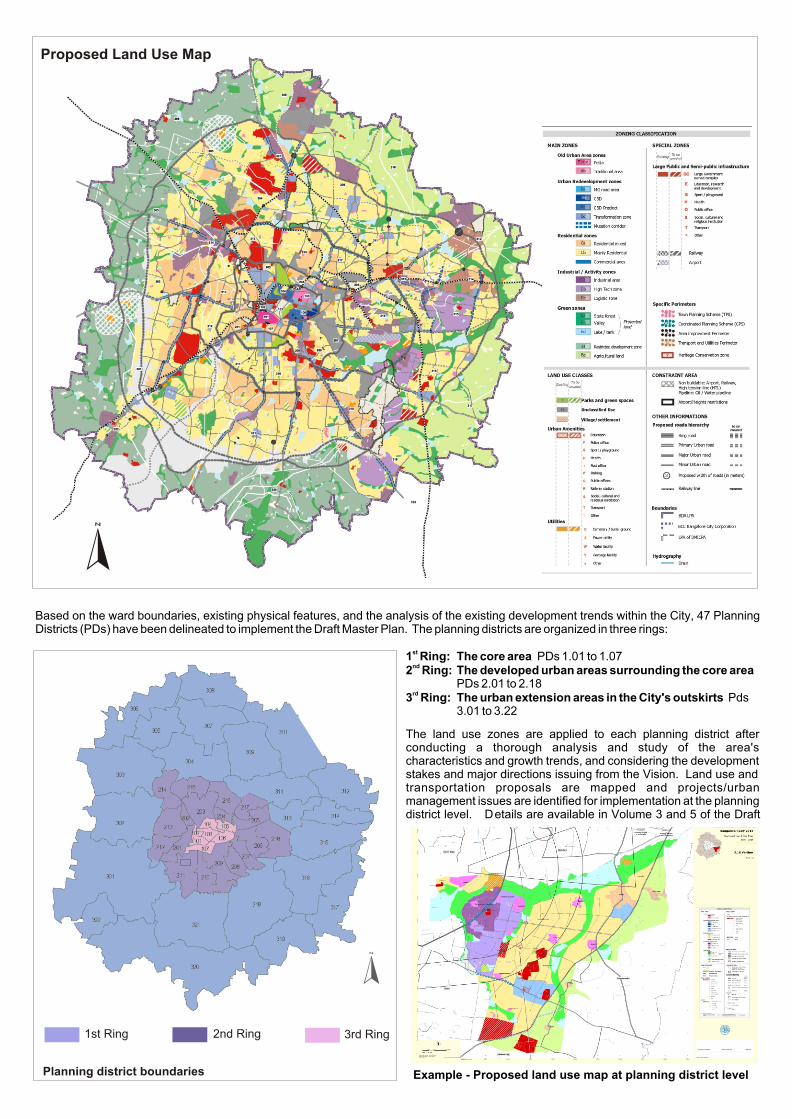
Proposed Land Use Map
Based on the ward boundaries, existing physical features, and the analysis of the existing development trends within the City, 47 Planning Districts (PDs) have been delineated to implement the Draft Master Plan. The planning districts are organized in three rings:
st1 Ring: The core area PDs 1.01 to 1.07nd2 Ring: The developed urban areas surrounding the core area
PDs 2.01 to 2.18rd3 Ring: The urban extension areas in the City's outskirts Pds
3.01 to 3.22
The land use zones are applied to each planning district after conducting a thorough analysis and study of the area's characteristics and growth trends, and considering the development stakes and major directions issuing from the Vision. Land use and transportation proposals are mapped and projects/urban management issues are identified for implementation at the planning district level. Details are available in Volume 3 and 5 of the Draft
2nd Ring1st Ring 3rd Ring
Example - Proposed land use map at planning district level
Bangalore Development Authority
Contact:The CommissionerBangalore Development AuthorityT. Chowdaiah Road, Kumara Park West, Bangalore 560020Phone: 91-80-23360843Fax: 91-80-23345799E-mail: tpmURL: www.bdabangalore.org
@bdabangalore.org
Visit:The Bangalore Master Plan 2015 exhibition at:
ndThe Auditorium Hall, 2 Floor, “YAVANIKA,” Nrupatunga Road, KR Circle, Bangalore 560 001.
th thDates: 27 June to 26 August 2005Time: 10:00 AM to 5:00 PM (on all working days)
Send Us Your Feedback!
We are eagerly looking forward to your reaction.