Embed Size (px)
Citation preview
BASIC ASSESSMENT REPORT
1
(For official use only)
File Reference Number:
Application Number:
Date Received:
Basic assessment report in terms of the Environmental Impact Assessment Regulations, 2010, promulgated in terms of the National Environmental Management Act, 1998 (Act No. 107 of 1998), as amended. Kindly note that: 1. This basic assessment report is a standard report that may be required by a competent authority in terms of the EIA
Regulations, 2010 and is meant to streamline applications. Please make sure that it is the report used by the particular competent authority for the activity that is being applied for.
2. The report must be typed within the spaces provided in the form. The size of the spaces provided is not necessarily
indicative of the amount of information to be provided. The report is in the form of a table that can extend itself as each space is filled with typing.
3. Where applicable tick the boxes that are applicable in the report. 4. An incomplete report may be returned to the applicant for revision. 5. The use of ―not applicable‖ in the report must be done with circumspection because if it is used in respect of material
information that is required by the competent authority for assessing the application, it may result in the rejection of the application as provided for in the regulations.
6. This report must be handed in at offices of the relevant competent authority as determined by each authority. 7. No faxed or e-mailed reports will be accepted. 8. The report must be compiled by an independent environmental assessment practitioner. 9. Unless protected by law, all information in the report will become public information on receipt by the competent
authority. Any interested and affected party should be provided with the information contained in this report on request, during any stage of the application process.
10. A competent authority may require that for specified types of activities in defined situations only parts of this report
need to be completed.

BASIC ASSESSMENT REPORT
2
SECTION A: ACTIVITY INFORMATION
Has a specialist been consulted to assist with the completion of this section?
YES NO
If YES, please complete the form entitled ―Details of specialist and declaration of interest‖
for appointment of a specialist for each specialist thus appointed: Any specialist reports must be contained in Appendix D. 1. ACTIVITY DESCRIPTION Describe the activity, which is being applied for, in detail1:
The South African National Roads Agency Limited (SANRAL) has commissioned the design
and construction of various pedestrian facilities along the National Route 3 Section 1 following
a report published in 2009 titled ―Pedestrian Safety Audit at Eight Locations Along the N2 and
N3 in KwaZulu-Natal‖. The report recorded the N3 Section 1 as a major pedestrian route. This
application is based on only a portion of the entire project scope, which includes a pedestrian
bridge and various footpaths within and beyond the road reserve. The full project scope is
detailed in the design report, attached in Appendix G; however section 7 of the design report is
applicable to this environmental application.
The project details that follow are based on the area depicted in the various locality maps found
in Appendix A.
It is proposed to formalize several existing footpaths between the N3 Section 1 (KM 25.0) near
the Marianhill Toll Plaza and the Tshelimnyama township. The project also involves the
construction of a pedestrian footbridge over the N3 Section 1 at KM 25.0.
According to the design report, the footpath adjacent to the N3 southbound carriageway will
follow the existing roadway profile as the gradient is suitable for pedestrians. Further down the
valley towards the Tshelimnyama Township, the design engineers have proposed a maximum
gradient of 1:5. Where the gradient exceeds this 1:5 gradient, the footpath will incorporate
stairs at 200mm rise vertically and 1m step horizontally.
1 Please note that this description should not be a verbatim repetition of the listed activity as contained in the relevant
Government Notice, but should be a brief description of activities to be undertaken as per the project description.
BASIC ASSESSMENT REPORT
3
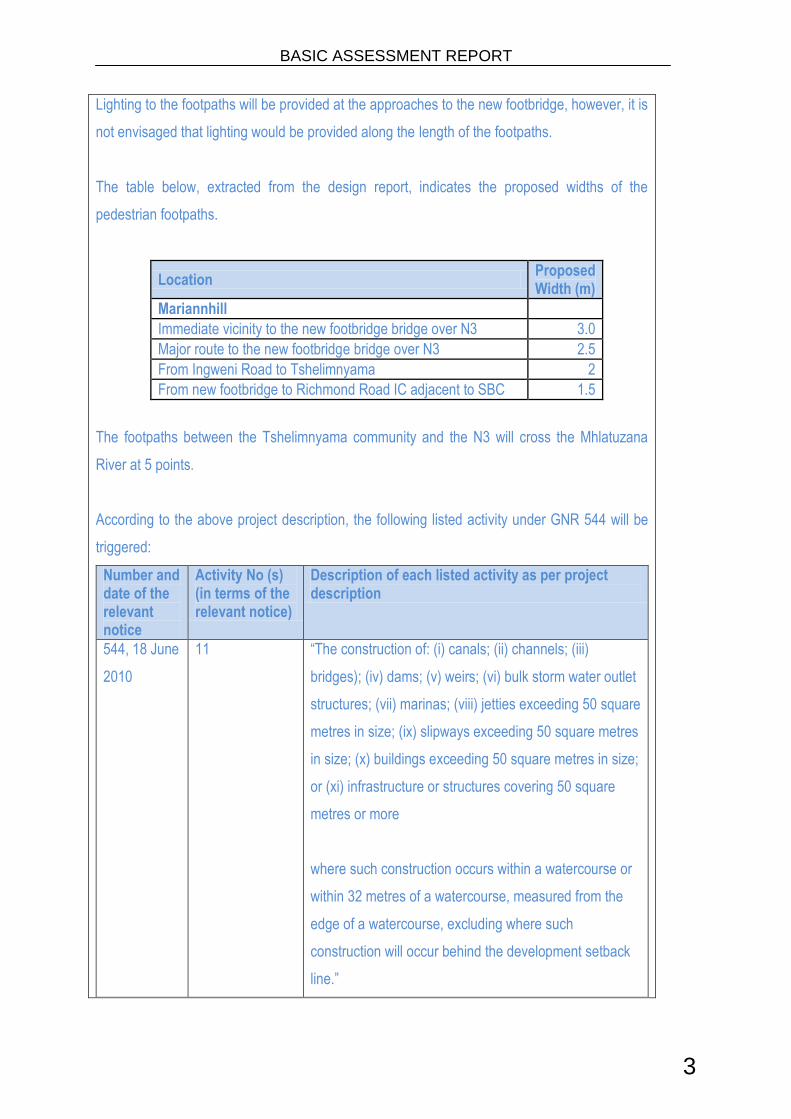
Lighting to the footpaths will be provided at the approaches to the new footbridge, however, it is
not envisaged that lighting would be provided along the length of the footpaths.
The table below, extracted from the design report, indicates the proposed widths of the
pedestrian footpaths.
Location Proposed Width (m)
Mariannhill
Immediate vicinity to the new footbridge bridge over N3 3.0
Major route to the new footbridge bridge over N3 2.5
From Ingweni Road to Tshelimnyama 2
From new footbridge to Richmond Road IC adjacent to SBC 1.5
The footpaths between the Tshelimnyama community and the N3 will cross the Mhlatuzana
River at 5 points.
According to the above project description, the following listed activity under GNR 544 will be
triggered:
Number and date of the relevant notice
Activity No (s) (in terms of the relevant notice)
Description of each listed activity as per project description
544, 18 June
2010
11 ―The construction of: (i) canals; (ii) channels; (iii)
bridges); (iv) dams; (v) weirs; (vi) bulk storm water outlet
structures; (vii) marinas; (viii) jetties exceeding 50 square
metres in size; (ix) slipways exceeding 50 square metres
in size; (x) buildings exceeding 50 square metres in size;
or (xi) infrastructure or structures covering 50 square
metres or more
where such construction occurs within a watercourse or
within 32 metres of a watercourse, measured from the
edge of a watercourse, excluding where such
construction will occur behind the development setback
line.‖

BASIC ASSESSMENT REPORT
4
2. FEASIBLE AND REASONABLE ALTERNATIVES “Alternatives”, in relation to a proposed activity, means different means of meeting the general purpose and requirements of the activity, which may include alternatives to— (a) the property on which or location where it is proposed to undertake the activity; (b) the type of activity to be undertaken; (c) the design or layout of the activity; (d) the technology to be used in the activity; (e) the operational aspects of the activity; and (f) the option of not implementing the activity. Describe alternatives that are considered in this application. Alternatives should include a consideration of all possible means by which the purpose and need of the proposed activity could be accomplished in the specific instance taking account of the interest of the applicant in the activity. The no-go alternative must in all cases be included in the assessment phase as the baseline against which the impacts of the other alternatives are assessed. The determination of whether site or activity (including different processes etc.) or both is appropriate needs to be informed by the specific circumstances of the activity and its environment. After receipt of this report the competent authority may also request the applicant to assess additional alternatives that could possibly accomplish the purpose and need of the proposed activity if it is clear that realistic alternatives have not been considered to a reasonable extent. Paragraphs 3 – 13 below should be completed for each alternative.
1. Preferred Technology Alternative (A1) The preferred activity alternative is based on the preferred technology type. No site alternative has been considered as the footpaths already exist and this application is based on the formalisation of these existing pathways. The preferred layout has been chosen based on the most frequented footpaths. The alternative considered is a technology alternative based on the retaining structures for these formalised footpaths. The preferred technology alternative is based on the following details provided by the project engineers:

BASIC ASSESSMENT REPORT
5
CUTTINGS
RocEnviro-Wall
The RocEnviro-Wall is a gravity retaining wall constructed of dry stacked interlocking, precast blocks. The simplicity of the design enables blocks to be easily and rapidly laid to form an effective retaining wall system. The RocEnviro-Wall is capable of supporting a wide range of embankment heights. For high and vertical walls a reinforced fill is required. Block walls can be constructed with open or closed joints. The latter avoids the problem of vegetation growth and the associated maintenance. The blocks are available in different colours and face textures for a more natural look. A typical configuration is shown below.
EMBANKMENT FILLS
Green Terramesh
The Green Terramesh™ is an environmentally friendly modular system used for soil reinforcement in mechanically stabilised slopes and embankments.
Green Terramesh™ units are factory assembled units manufactured from continuous, heavily galvanised and PVC coated steel wire mesh. The facing section of the unit is reinforced with additional PVC coated steel rods.
Attached to the inside facing is a geosynthetic or a biodegradable Erosion Control Blanket (ECB), a welded steel panel and two steel brackets, preformed to a 70° slope angle. The ECB protects the backfill soil and permits a vegetative cover to establish rapidly. The welded steel panel placed behind the ECB adds strength and provides support to the facing while holding the blanket in place during construction
Typical Green Terramesh Section
Green Terramesh System Support a Road Embankment

BASIC ASSESSMENT REPORT
6
3. ACTIVITY POSITION Indicate the position of the activity using the latitude and longitude of the centre point of the site for each alternative site. The co-ordinates should be in degrees and decimal minutes. The minutes should have at least three decimals to ensure adequate accuracy. The projection that must be used in all cases is the WGS84 spheroid in a national or local projection. List alternative sites, if applicable. Alternative:
Latitude (S):
Longitude (E):
River crossing 1 29° 49.6315’ 30° 48.6315’
River crossing 2 29° 49.5683’ 30° 48.3010’
River crossing 3 29° 49.4963’ 30° 48.3338’
River crossing 4 29° 49.5772’ 30° 48.4781’
River crossing 5 29° 49.7352’ 30° 48.5521’
Alternative S3 (if any) o ‗ o ‗
In the case of linear activities: Alternative: Latitude (S): Longitude (E): Alternative S1 (preferred or only route alternative)
Starting point of the activity
Middle/Additional point of the activity
End point of the activity
Alternative S2 (if any)
Starting point of the activity o ‗ o ‗
Middle/Additional point of the activity o ‗ o ‗
End point of the activity o ‗ o ‗
Alternative S3 (if any)
Starting point of the activity o ‗ o ‗
Middle/Additional point of the activity o ‗ o ‗
End point of the activity o ‗ o ‗
For route alternatives that are longer than 500m, please provide an addendum with co-ordinates taken every 250 meters along the route for each alternative alignment. 4. PHYSICAL SIZE OF THE ACTIVITY Indicate the physical size of the preferred activity/technology as well as alternative activities/technologies (footprints): Alternative: Size of the activity:
Alternative A12 (preferred activity alternative) m2
Alternative A2 (if any) m2
2 “Alternative A..” refer to activity, process, technology or other alternatives.

BASIC ASSESSMENT REPORT
7
Alternative A3 (if any) m2
or, for linear activities: Alternative:
Length of the activity:
Alternative A1 (preferred activity alternative) Total cumulative length of footpaths 2800m
Alternative A2 (if any) m
Alternative A3 (if any) m
Indicate the size of the alternative sites or servitudes (within which the above footprints will occur): Alternative:
Size of the site/servitude:
Alternative A1 (preferred activity alternative) Portion 236 of Farm Number 937, Zeekoegat
1 315 415m²
Alternative A2 (if any) m2
Alternative A3 (if any) m2
5. SITE ACCESS
Does ready access to the site exist? YES NO
If NO, what is the distance over which a new access road will be built m
Describe the type of access road planned:
Include the position of the access road on the site plan and required map, as well as an indication of the road in relation to the site. 6. SITE OR ROUTE PLAN
A detailed site or route plan(s) must be prepared for each alternative site or alternative activity. It must be attached as Appendix A to this document. The site or route plans must indicate the following: 6.1 the scale of the plan which must be at least a scale of 1:500; 6.2 the property boundaries and numbers of all the properties within 50 metres of the site; 6.3 the current land use as well as the land use zoning of each of the properties adjoining the site or
sites; 6.4 the exact position of each element of the application as well as any other structures on the site; 6.5 the position of services, including electricity supply cables (indicate above or underground), water
supply pipelines, boreholes, street lights, sewage pipelines, storm water infrastructure and telecommunication infrastructure;
6.6 all trees and shrubs taller than 1.8 metres; 6.7 walls and fencing including details of the height and construction material; 6.8 servitudes indicating the purpose of the servitude; 6.9 sensitive environmental elements within 100 metres of the site or sites including (but not limited
thereto):

BASIC ASSESSMENT REPORT
8
rivers; the 1:100 year flood line (where available or where it is required by DWA); ridges; cultural and historical features; areas with indigenous vegetation (even if it is degraded or invested with alien species);
6.10 for gentle slopes the 1 metre contour intervals must be indicated on the plan and whenever the slope of the site exceeds 1:10, the 500mm contours must be indicated on the plan; and
6.11 the positions from where photographs of the site were taken. 7. SITE PHOTOGRAPHS Colour photographs from the centre of the site must be taken in at least the eight major compass directions with a description of each photograph. Photographs must be attached under Appendix B to this form. It must be supplemented with additional photographs of relevant features on the site, if applicable. 8. FACILITY ILLUSTRATION A detailed illustration of the activity must be provided at a scale of 1:200 as Appendix C for activities that include structures. The illustrations must be to scale and must represent a realistic image of the planned activity. The illustration must give a representative view of the activity. 9. ACTIVITY MOTIVATION 9(a) Socio-economic value of the activity
What is the expected capital value of the activity on completion? R60 mil
What is the expected yearly income that will be generated by or as a result of the activity?
N / A
Will the activity contribute to service infrastructure? YES NO
Is the activity a public amenity? YES NO
How many new employment opportunities will be created in the development phase of the activity?
Approx. 50
What is the expected value of the employment opportunities during the development phase?
Approx R60 mil over 12 months
What percentage of this will accrue to previously disadvantaged individuals? Approx 80%
How many permanent new employment opportunities will be created during the operational phase of the activity?
N/A
What is the expected current value of the employment opportunities during the first 10 years?
Approx R60 mil over 12 months only
What percentage of this will accrue to previously disadvantaged individuals? Approx 80%
9(b) Need and desirability of the activity Motivate and explain the need and desirability of the activity (including demand for the activity):
NEED:
1. Was the relevant provincial planning department involved in the application?
YES NO
BASIC ASSESSMENT REPORT
9
2. Does the proposed land use fall within the relevant provincial planning framework?
YES NO
3. If the answer to questions 1 and / or 2 was NO, please provide further motivation / explanation:
DESIRABILITY:
1. Does the proposed land use / development fit the surrounding area? YES NO
2. Does the proposed land use / development conform to the relevant structure plans, SDF and planning visions for the area?
YES NO
3. Will the benefits of the proposed land use / development outweigh the negative impacts of it?
YES NO
4. If the answer to any of the questions 1-3 was NO, please provide further motivation / explanation:
5. Will the proposed land use / development impact on the sense of place? YES NO
6. Will the proposed land use / development set a precedent? YES NO
7. Will any person‘s rights be affected by the proposed land use / development?
YES NO
8. Will the proposed land use / development compromise the ―urban edge‖? YES NO
9. If the answer to any of the question 5-8 was YES, please provide further motivation / explanation.
BENEFITS:
1. Will the land use / development have any benefits for society in general? YES NO
2. Explain:
Aurecon published a report in 2009 titled ―Pedestrian Safety Audit at Eight Locations Along the N2 and N3 in KwaZulu-Natal‖. In this report, major pedestrian routes intersecting with the N2 and N3 were identified. The eight locations identified were investigated further and discussed with the local communities to provide formalized footpaths that would be suitable for the applicable communities. The Mariannhill site was one of the sites identified along the N3. At this location, the Tshelimnyama community is separated from a primary source of employment, namely, the Mahogony Ridge, Westmead, Westmead Extension and Alexander Park industrial areas which are just north of the N3 Section 1. The pedestrian footbridge, which is currently being constructed, will provide for safe crossing of the N3. The existing footpaths that link the Tshelimnyama community to the pedestrian footbridge are in a degraded state and the various river crossings identified are dangerous to cross during high flow. The formalization of these footpaths will provide a safe walking route for these pedestrians and will assist in the upliftment of the local community.

BASIC ASSESSMENT REPORT
10
3. Will the land use / development have any benefits for the local communities where it will be located?
YES NO
4. Explain:
The existing footpaths that link the Tshelimnyama community to the pedestrian footbridge are in a degraded state and the various river crossings identified are dangerous to cross during high flow. The formalization of these footpaths will provide a safe walking route for these pedestrians and will assist in the upliftment of the local community. Furthermore, there will be the opportunity for some short term job creation during the construction phase of the project.
10. APPLICABLE LEGISLATION, POLICIES AND/OR GUIDELINES List all legislation, policies and/or guidelines of any sphere of government that are applicable to the application as contemplated in the EIA regulations, if applicable: Title of legislation, policy or guideline:
Administering authority:
Date:
Hazardous Substances Act (Act No 15 of 1973) Department of Health (DOH)
1973
National Water Act (Act No 36 of 1998) Department of Water Affairs (DWA)
1998
National Environmental Management Act (Act No 107 of 1998 [NEMA]) as amended
DEA 1998
National Heritage Resources Act (Act No 25 OF 1999)
South African Heritage Resources Agency (SAHRA)/ Amafa AkwaZulu-Natali (Amafa)
1999
National Environmental Management Protected Areas Act (Act No 57 OF 2003 [NEMPA])
DEA 2003
National Environmental Management Biodiversity Act (Act 10 of 2004)
DEA 2004
National Environmental Management – Waste Act (Act 59 of 2008)
Department of Agriculture, Environmental Affairs and Rural Development (DAEARD) / DEA
2008
11. WASTE, EFFLUENT, EMISSION AND NOISE MANAGEMENT 11(a) Solid waste management
Will the activity produce solid construction waste during the construction/initiation phase?
YES NO
If yes, what estimated quantity will be produced per month? 4m3
How will the construction solid waste be disposed of (describe)?
Solid waste generated during the construction phase will be stored in skips on site. These skips will be transported by road to the local municipal landfill site fortnightly or as needed.
Where will the construction solid waste be disposed of (describe)?

BASIC ASSESSMENT REPORT
11
Domestic/site office solid waste amounting to approximately 4m³ per month for 12 months and for roadworks rubble amounting to approximately 48m3 to be disposed of at an eThekwini Municipality landfill site.
Will the activity produce solid waste during its operational phase? YES NO
If yes, what estimated quantity will be produced per month? m3
How will the solid waste be disposed of (describe)?
Where will the solid waste be disposed if it does not feed into a municipal waste stream (describe)?
If the solid waste (construction or operational phases) will not be disposed of in a registered landfill site or be taken up in a municipal waste stream, then the applicant should consult with the competent authority to determine whether it is necessary to change to an application for scoping and EIA.
Can any part of the solid waste be classified as hazardous in terms of the relevant legislation?
YES NO
If yes, inform the competent authority and request a change to an application for scoping and EIA.
Is the activity that is being applied for a solid waste handling or treatment facility?
YES NO
If yes, then the applicant should consult with the competent authority to determine whether it is necessary to change to an application for scoping and EIA. 11(b) Liquid effluent
Will the activity produce effluent, other than normal sewage, that will be disposed of in a municipal sewage system?
YES NO
If yes, what estimated quantity will be produced per month? m3
Will the activity produce any effluent that will be treated and/or disposed of on site?
YES NO
If yes, the applicant should consult with the competent authority to determine whether it is necessary to change to an application for scoping and EIA.
Will the activity produce effluent that will be treated and/or disposed of at another facility?
YES NO
If yes, provide the particulars of the facility:
Facility name:
Contact person:
Postal address:
Postal code:
Telephone: Cell:
E-mail: Fax:
Describe the measures that will be taken to ensure the optimal reuse or recycling of waste water, if any:
11(c) Emissions into the atmosphere

BASIC ASSESSMENT REPORT
12
Will the activity release emissions into the atmosphere? YES NO
If yes, is it controlled by any legislation of any sphere of government? YES NO
If yes, the applicant should consult with the competent authority to determine whether it is necessary to change to an application for scoping and EIA.
If no, describe the emissions in terms of type and concentration:
Emissions will take the form of dust and engine emissions that will result from the operation of vehicles and construction equipment on site. This will be limited to the construction period.
11(d) Generation of noise
Will the activity generate noise? YES NO
If yes, is it controlled by any legislation of any sphere of government? YES NO
If yes, the applicant should consult with the competent authority to determine whether it is necessary to change to an application for scoping and EIA.
If no, describe the noise in terms of type and level:
Noise produced will be from vehicles and equipment during the construction phase only.
12. WATER USE Please indicate the source(s) of water that will be used for the activity by ticking the appropriate box(es)
municipal water board groundwater river, stream, dam or lake
other the activity will not use water
If water is to be extracted from groundwater, river, stream, dam, lake or any other natural feature, please indicate
the volume that will be extracted per month: 9,600m³
Does the activity require a water use permit from the Department of Water Affairs?
YES NO
If yes, please submit the necessary application to the Department of Water Affairs and attach proof thereof to this application if it has been submitted. 13. ENERGY EFFICIENCY Describe the design measures, if any, that have been taken to ensure that the activity is energy efficient:
The type of project does not allow for the design measures that can make the project more energy efficient.
Describe how alternative energy sources have been taken into account or been built into the design of the activity, if any:
The type of project does not allow for the use of alternative energy sources.
ALTERNATIVES
Technology Alternative (A2) The alternative considered is based on an alternate technology type. No site alternative has been considered as the footpaths already exist and this application is based on the formalisation of these existing pathways. The preferred layout has been chosen based on the most frequented footpaths. The technology alternative considered is based on the following details provided by the project engineers:

BASIC ASSESSMENT REPORT
13
CUTTINGS
Terratrel® – MSE Wire Faced Retaining Wall
Terratrel® MSE retaining walls are coherent gravity structures engineered to resist specific loading requirements. It combines the performance and structural integrity of Reinforced Earth, with the economy of wire facing. The primary components of a Terratrel wall consist of alternating layers of granular backfill, and soil reinforcements to which a modular wire facing is attached. The reinforcing strips would have to be rock anchored into the cutting to ensure the stability of the footpath.
Typical Terratrel configuration detail
Terratrel supporting an embankment
3. ACTIVITY POSITION Indicate the position of the activity using the latitude and longitude of the centre point of the site for each alternative site. The co-ordinates should be in degrees and decimal minutes. The minutes should have at least three decimals to ensure adequate accuracy. The projection that must be used in all cases is the WGS84 spheroid in a national or local projection. List alternative sites, if applicable.

BASIC ASSESSMENT REPORT
14
Alternative:
Latitude (S):
Longitude (E):
River crossing 1 29° 49.6315’ 30° 48.6315’
River crossing 2 29° 49.5683’ 30° 48.3010’
River crossing 3 29° 49.4963’ 30° 48.3338’
River crossing 4 29° 49.5772’ 30° 48.4781’
River crossing 5 29° 49.7352’ 30° 48.5521’
Alternative S3 (if any) o ‗ o ‗
In the case of linear activities: Alternative: Latitude (S): Longitude (E): Alternative S1 (preferred or only route alternative)
Starting point of the activity o ‗ o ‗
Middle/Additional point of the activity o ‗ o ‗
End point of the activity o ‗ o ‗
Alternative S2 (if any)
Starting point of the activity o ‗ o ‗
Middle/Additional point of the activity o ‗ o ‗
End point of the activity o ‗ o ‗
Alternative S3 (if any)
Starting point of the activity o ‗ o ‗
Middle/Additional point of the activity o ‗ o ‗
End point of the activity o ‗ o ‗
For route alternatives that are longer than 500m, please provide an addendum with co-ordinates taken every 250 meters along the route for each alternative alignment. 4. PHYSICAL SIZE OF THE ACTIVITY Indicate the physical size of the preferred activity/technology as well as alternative activities/technologies (footprints): Alternative: Size of the activity:
Alternative A13 (preferred activity alternative) m2
Alternative A2 (if any) m2
Alternative A3 (if any) m2
or, for linear activities: Alternative:
Length of the activity:
Alternative A1 (preferred activity alternative) Total cumulative length of footpaths 2800m
Alternative A2 (if any) m
Alternative A3 (if any) m
3 “Alternative A..” refer to activity, process, technology or other alternatives.

BASIC ASSESSMENT REPORT
15
Indicate the size of the alternative sites or servitudes (within which the above footprints will occur): Alternative:
Size of the site/servitude:
Alternative A1 (preferred activity alternative) Portion 236 of Farm Number 937, Zeekoegat
1 315 415m²
Alternative A2 (if any) m2
Alternative A3 (if any) m2
5. SITE ACCESS
Does ready access to the site exist? YES NO
If NO, what is the distance over which a new access road will be built m
Describe the type of access road planned:
Include the position of the access road on the site plan and required map, as well as an indication of the road in relation to the site. 6. SITE OR ROUTE PLAN
A detailed site or route plan(s) must be prepared for each alternative site or alternative activity. It must be attached as Appendix A to this document. The site or route plans must indicate the following: 6.1 the scale of the plan which must be at least a scale of 1:500; 6.2 the property boundaries and numbers of all the properties within 50 metres of the site; 6.3 the current land use as well as the land use zoning of each of the properties adjoining the site or
sites; 6.4 the exact position of each element of the application as well as any other structures on the site; 6.5 the position of services, including electricity supply cables (indicate above or underground), water
supply pipelines, boreholes, street lights, sewage pipelines, storm water infrastructure and telecommunication infrastructure;
6.6 all trees and shrubs taller than 1.8 metres; 6.7 walls and fencing including details of the height and construction material; 6.8 servitudes indicating the purpose of the servitude; 6.9 sensitive environmental elements within 100 metres of the site or sites including (but not limited
thereto): rivers; the 1:100 year flood line (where available or where it is required by DWA); ridges; cultural and historical features; areas with indigenous vegetation (even if it is degraded or invested with alien species);
6.10 for gentle slopes the 1 metre contour intervals must be indicated on the plan and whenever the slope of the site exceeds 1:10, the 500mm contours must be indicated on the plan; and
6.11 the positions from where photographs of the site were taken. 7. SITE PHOTOGRAPHS
BASIC ASSESSMENT REPORT
16
Colour photographs from the centre of the site must be taken in at least the eight major compass directions with a description of each photograph. Photographs must be attached under Appendix B to this form. It must be supplemented with additional photographs of relevant features on the site, if applicable. 8. FACILITY ILLUSTRATION A detailed illustration of the activity must be provided at a scale of 1:200 as Appendix C for activities that include structures. The illustrations must be to scale and must represent a realistic image of the planned activity. The illustration must give a representative view of the activity. 9. ACTIVITY MOTIVATION 9(a) Socio-economic value of the activity
What is the expected capital value of the activity on completion? R60 mil
What is the expected yearly income that will be generated by or as a result of the activity?
N / A
Will the activity contribute to service infrastructure? YES NO
Is the activity a public amenity? YES NO
How many new employment opportunities will be created in the development phase of the activity?
Approx. 50
What is the expected value of the employment opportunities during the development phase?
Approx R60 mil over 12 months
What percentage of this will accrue to previously disadvantaged individuals? Approx 80%
How many permanent new employment opportunities will be created during the operational phase of the activity?
N/A
What is the expected current value of the employment opportunities during the first 10 years?
Approx R60 mil over 12 months only
What percentage of this will accrue to previously disadvantaged individuals? Approx 80%
9(b) Need and desirability of the activity Motivate and explain the need and desirability of the activity (including demand for the activity):
NEED:
1. Was the relevant provincial planning department involved in the application?
YES NO
2. Does the proposed land use fall within the relevant provincial planning framework?
YES NO
3. If the answer to questions 1 and / or 2 was NO, please provide further motivation / explanation:
DESIRABILITY:

BASIC ASSESSMENT REPORT
17
1. Does the proposed land use / development fit the surrounding area? YES NO
2. Does the proposed land use / development conform to the relevant structure plans, SDF and planning visions for the area?
YES NO
3. Will the benefits of the proposed land use / development outweigh the negative impacts of it?
YES NO
4. If the answer to any of the questions 1-3 was NO, please provide further motivation / explanation:
5. Will the proposed land use / development impact on the sense of place? YES NO
6. Will the proposed land use / development set a precedent? YES NO
7. Will any person‘s rights be affected by the proposed land use / development?
YES NO
8. Will the proposed land use / development compromise the ―urban edge‖? YES NO
9. If the answer to any of the question 5-8 was YES, please provide further motivation / explanation.
BENEFITS:
1. Will the land use / development have any benefits for society in general? YES NO
2. Explain:
Aurecon published a report in 2009 titled ―Pedestrian Safety Audit at Eight Locations Along the N2 and N3 in KwaZulu-Natal‖. In this report, major pedestrian routes intersecting with the N2 and N3 were identified. The eight locations identified were investigated further and discussed with the local communities to provide formalized footpaths that would be suitable for the applicable communities. The Mariannhill site was one of the sites identified along the N3. At this location, the Tshelimnyama community is separated from a primary source of employment, namely, the Mahogony Ridge, Westmead, Westmead Extension and Alexander Park industrial areas which are just north of the N3 Section 1. The pedestrian footbridge, which is currently being constructed, will provide for safe crossing of the N3. The existing footpaths that link the Tshelimnyama community to the pedestrian footbridge are in a degraded state and the various river crossings identified are dangerous to cross during high flow. The formalization of these footpaths will provide a safe walking route for these pedestrians and will assist in the upliftment of the local community.
3. Will the land use / development have any benefits for the local communities where it will be located?
YES NO
4. Explain:
The existing footpaths that link the Tshelimnyama community to the pedestrian footbridge are in a degraded state and the various river crossings identified are dangerous to cross during high flow. The formalization of these footpaths will provide a safe walking route for these pedestrians and will assist in the upliftment of the local community.
BASIC ASSESSMENT REPORT
18
Furthermore, there will be the opportunity for some short term job creation during the construction phase of the project.
10. APPLICABLE LEGISLATION, POLICIES AND/OR GUIDELINES List all legislation, policies and/or guidelines of any sphere of government that are applicable to the application as contemplated in the EIA regulations, if applicable: Title of legislation, policy or guideline:
Administering authority:
Date:
Hazardous Substances Act (Act No 15 of 1973) Department of Health (DOH)
1973
National Water Act (Act No 36 of 1998) Department of Water Affairs (DWA)
1998
National Environmental Management Act (Act No 107 of 1998 [NEMA]) as amended
DEA 1998
National Heritage Resources Act (Act No 25 OF 1999)
South African Heritage Resources Agency (SAHRA)/ Amafa aKwaZulu-Natali (Amafa)
1999
National Environmental Management Protected Areas Act (Act No 57 OF 2003 [NEMPA])
DEA 2003
National Environmental Management Biodiversity Act (Act 10 of 2004)
DEA 2004
National Environmental Management – Waste Act (Act 59 of 2008)
Department of Agriculture, Environmental Affairs and Rural Development (DAEARD) / DEA
2008
11. WASTE, EFFLUENT, EMISSION AND NOISE MANAGEMENT 11(a) Solid waste management
Will the activity produce solid construction waste during the construction/initiation phase?
YES NO
If yes, what estimated quantity will be produced per month? 4m3
How will the construction solid waste be disposed of (describe)?
Solid waste generated during the construction phase will be stored in skips on site. These skips will be transported by road to the local municipal landfill site fortnightly or as needed.
Where will the construction solid waste be disposed of (describe)?
Domestic/site office solid waste amounting to approximately 4m³ per month for 12 months and for roadworks rubble amounting to approximately 48m3 to be disposed of at an eThekwini Municipality landfill site.
Will the activity produce solid waste during its operational phase? YES NO
If yes, what estimated quantity will be produced per month? m3
How will the solid waste be disposed of (describe)?
Where will the solid waste be disposed if it does not feed into a municipal waste stream (describe)?

BASIC ASSESSMENT REPORT
19
If the solid waste (construction or operational phases) will not be disposed of in a registered landfill site or be taken up in a municipal waste stream, then the applicant should consult with the competent authority to determine whether it is necessary to change to an application for scoping and EIA.
Can any part of the solid waste be classified as hazardous in terms of the relevant legislation?
YES NO
If yes, inform the competent authority and request a change to an application for scoping and EIA.
Is the activity that is being applied for a solid waste handling or treatment facility?
YES NO
If yes, then the applicant should consult with the competent authority to determine whether it is necessary to change to an application for scoping and EIA. 11(b) Liquid effluent
Will the activity produce effluent, other than normal sewage, that will be disposed of in a municipal sewage system?
YES NO
If yes, what estimated quantity will be produced per month? m3
Will the activity produce any effluent that will be treated and/or disposed of on site?
YES NO
If yes, the applicant should consult with the competent authority to determine whether it is necessary to change to an application for scoping and EIA.
Will the activity produce effluent that will be treated and/or disposed of at another facility?
YES NO
If yes, provide the particulars of the facility:
Facility name:
Contact person:
Postal address:
Postal code:
Telephone: Cell:
E-mail: Fax:
Describe the measures that will be taken to ensure the optimal reuse or recycling of waste water, if any:
11(c) Emissions into the atmosphere
Will the activity release emissions into the atmosphere? YES NO
If yes, is it controlled by any legislation of any sphere of government? YES NO
If yes, the applicant should consult with the competent authority to determine whether it is necessary to change to an application for scoping and EIA.
If no, describe the emissions in terms of type and concentration:
Emissions will take the form of dust and engine emissions that will result from the operation of vehicles and construction equipment on site. This will be limited to the construction period.
11(d) Generation of noise
BASIC ASSESSMENT REPORT
20
Will the activity generate noise? YES NO
If yes, is it controlled by any legislation of any sphere of government? YES NO
If yes, the applicant should consult with the competent authority to determine whether it is necessary to change to an application for scoping and EIA.
If no, describe the noise in terms of type and level:
Noise produced will be from vehicles and equipment during the construction phase only.
12. WATER USE Please indicate the source(s) of water that will be used for the activity by ticking the appropriate box(es)
municipal water board groundwater river, stream, dam or lake
other the activity will not use water
If water is to be extracted from groundwater, river, stream, dam, lake or any other natural feature, please indicate
the volume that will be extracted per month: 9,600m³
Does the activity require a water use permit from the Department of Water Affairs?
YES NO
If yes, please submit the necessary application to the Department of Water Affairs and attach proof thereof to this application if it has been submitted. 13. ENERGY EFFICIENCY Describe the design measures, if any, that have been taken to ensure that the activity is energy efficient:
The type of project does not allow for the design measures that can make the project more energy efficient.
Describe how alternative energy sources have been taken into account or been built into the design of the activity, if any:
The type of project does not allow for the use of alternative energy sources.
SECTION B: SITE/AREA/PROPERTY DESCRIPTION
Preferred Technology Alternative (A1) The preferred activity alternative is based on the preferred technology type. No site alternative has been considered as the footpaths already exist and this application is based on the formalisation of these existing pathways. The preferred layout has been chosen based on the most frequented footpaths. The alternative considered is a technology alternative based on the retaining structures for these formalised footpaths. Important notes:
1. For linear activities (pipelines, etc) as well as activities that cover very large sites, it may be necessary to complete this section for each part of the site that has a significantly different environment. In such cases please complete copies of Section C and indicate the area, which is covered by each copy No. on the Site Plan.

BASIC ASSESSMENT REPORT
21
Section C Copy No. (e.g. A):
2. Paragraphs 1 - 6 below must be completed for each alternative.
3. Has a specialist been consulted to assist with the completion of this section?
YES NO
If YES, please complete the form entitled ―Details of specialist and declaration of interest‖
for each specialist thus appointed: All specialist reports must be contained in Appendix D. Property description/physical address:
National Route 3 Section 1 (KM 25.0) at Tshelimnyama. Portion 236 of Farm Number 937 Zeekoegat.
(Farm name, portion etc.) Where a large number of properties are involved (e.g. linear activities), please attach a full list to this application.
In instances where there is more than one town or district involved, please attach a list of towns or districts to this application.
Current land-use zoning: ‗Undeveloped‘ and ‗informal urban settlement‘
In instances where there is more than one current land-use zoning, please attach a list of current land use zonings that also indicate which portions each use pertains to , to this application.
Is a change of land-use or a consent use application required? YES NO
Must a building plan be submitted to the local authority?
YES NO
Locality map: An A3 locality map must be attached to the back of this document, as Appendix A. The scale of the locality map must be relevant to the size of the development (at least 1:50 000. For linear activities of more than 25 kilometres, a smaller scale e.g. 1:250 000 can be used. The scale must be indicated on the map.) The map must indicate the following:
an indication of the project site position as well as the positions of the alternative sites, if any;
road access from all major roads in the area;
road names or numbers of all major roads as well as the roads that provide access to the site(s);
all roads within a 1km radius of the site or alternative sites; and
a north arrow;
a legend; and
locality GPS co-ordinates (Indicate the position of the activity using the latitude and longitude of the centre point of the site for each alternative site. The co-ordinates should be in degrees and decimal minutes. The minutes should have at least three decimals to ensure adequate accuracy. The projection that must be used in all cases is the WGS84 spheroid in a national or local projection)
1. GRADIENT OF THE SITE

BASIC ASSESSMENT REPORT
22
Indicate the general gradient of the site. Alternative S1:
Flat 1:50 – 1:20
1:20 – 1:15
1:15 – 1:10 1:10 – 1:7,5
1:7,5 – 1:5 Steeper than 1:5
Alternative S2 (if any):
Flat 1:50 – 1:20
1:20 – 1:15
1:15 – 1:10 1:10 – 1:7,5
1:7,5 – 1:5 Steeper than 1:5
Alternative S3 (if any):
Flat 1:50 – 1:20
1:20 – 1:15
1:15 – 1:10 1:10 – 1:7,5
1:7,5 – 1:5 Steeper than 1:5
2. LOCATION IN LANDSCAPE Indicate the landform(s) that best describes the site: 2.1 Ridgeline 2.2 Plateau 2.3 Side slope of hill/mountain 2.4 Closed valley 2.5 Open valley 2.6 Plain 2.7 Undulating plain / low hills 2.8 Dune 2.9 Seafront 3. GROUNDWATER, SOIL AND GEOLOGICAL STABILITY OF THE SITE Is the site(s) located on any of the following (tick the appropriate boxes)? Alternative S1: Alternative S2
(if any): Alternative S3
(if any):
Shallow water table (less than 1.5m deep)
YES NO YES NO YES NO
Dolomite, sinkhole or doline areas
YES NO YES NO YES NO
Seasonally wet soils (often close to water bodies)
YES NO YES NO YES NO
Unstable rocky slopes or steep slopes with loose soil
YES NO YES NO YES NO
Dispersive soils (soils that dissolve in water)
YES NO YES NO YES NO
Soils with high clay content (clay fraction more than 40%)
YES NO YES NO YES NO
Any other unstable soil or geological feature
YES NO YES NO YES NO
An area sensitive to erosion
YES NO YES NO YES NO

BASIC ASSESSMENT REPORT
23
For the overall site the water table is unlikely to be shallower than 1.5m, in low lying areas and areas in close proximity to water courses a shallow water table may be present. These soils may be saturated, especially during the wet season. If you are unsure about any of the above or if you are concerned that any of the above aspects may be an issue of concern in the application, an appropriate specialist should be appointed to assist in the completion of this section. (Information in respect of the above will often be available as part of the project information or at the planning sections of local authorities. Where it exists, the 1:50 000 scale Regional Geotechnical Maps prepared by the Council for Geo Science may also be consulted). 4. GROUNDCOVER Indicate the types of groundcover present on the site: The location of all identified rare or endangered species or other elements should be accurately indicated on the site plan(s).
Natural veld - good conditionE
Natural veld with scattered aliensE
Natural veld with heavy alien infestationE
Veld dominated by alien speciesE
Gardens
Sport field Cultivated land
Paved surface Building or other structure
Bare soil
If any of the boxes marked with an ―E ―is ticked, please consult an appropriate specialist to assist in the completion of this section if the environmental assessment practitioner doesn‘t have the necessary expertise. 5. LAND USE CHARACTER OF SURROUNDING AREA Indicate land uses and/or prominent features that does currently occur within a 500m radius of the site and give description of how this influences the application or may be impacted upon by the application: 5.1 Natural area
The existing natural area is not developed. The footpaths currently exist and will therefore not alter the natural area, except to change the surface substance of the footpaths to a paved surface.
Construction methods will need to incorporate mitigation measures to reduce negative impacts on the receiving natural environment.
5.2 Low density residential 5.3 Medium density residential
Medium density residential areas neighbouring the project site will be impacted on by the proposed project in a positive way. The footpaths are an important route for most residents in the Tshelimnyama community to reach the nearby industrial area.
5.4 High density residential 5.5 Informal residentialA
5.6 Retail commercial & warehousing 5.7 Light industrial 5.8 Medium industrial AN 5.9 Heavy industrial AN 5.10 Power station

BASIC ASSESSMENT REPORT
24
5.11 Office/consulting room 5.12 Military or police base/station/compound 5.13 Spoil heap or slimes damA 5.14 Quarry, sand or borrow pit 5.15 Dam or reservoir 5.16 Hospital/medical centre 5.17 School 5.18 Tertiary education facility 5.19 Church 5.20 Old age home 5.21 Sewage treatment plantA 5.22 Train station or shunting yard N 5.23 Railway line N
5.24 Major road (4 lanes or more) N
The N3 Section 1 intersects the proposed project as the footpaths lead to the pedestrian bridge that will be constructed over the N3.
5.25 Airport N 5.26 Harbour 5.27 Sport facilities 5.28 Golf course 5.29 Polo fields 5.30 Filling station H
5.31 Landfill or waste treatment site 5.32 Plantation 5.33 Agriculture 5.34 River, stream or wetland
There are 5 river crossings associated with this application. 5.35 Nature conservation area 5.36 Mountain, koppie or ridge 5.37 Museum 5.38 Historical building 5.39 Protected Area 5.40 Graveyard 5.41 Archaeological site 5.42 Other land uses (describe) None identified. If any of the boxes marked with an ―N ―are ticked, how will this impact / be impacted upon by the proposed activity? The N3 Section 1 intersects the proposed project as the footpaths lead to the pedestrian bridge that will be constructed over the N3. If any of the boxes marked with an "An" are ticked, how will this impact / be impacted upon by the proposed activity?
If YES, specify and explain:
If YES, specify:

BASIC ASSESSMENT REPORT
25
If any of the boxes marked with an "H" are ticked, how will this impact / be impacted upon by the proposed activity.
If YES, specify:
6. CULTURAL/HISTORICAL FEATURES
Are there any signs of culturally or historically significant elements, as defined in section 2 of the National Heritage Resources Act, 1999, (Act No. 25 of 1999), including
YES NO
Archaeological or palaeontological sites, on or close (within 20m) to the site?
Uncertain
If YES, explain:
If uncertain, conduct a specialist investigation by a recognised specialist in the field to establish whether there is such a feature(s) present on or close to the site.
Briefly explain the findings of the specialist:
Will any building or structure older than 60 years be affected in any way? YES NO
Is it necessary to apply for a permit in terms of the National Heritage Resources Act, 1999 (Act 25 of 1999)?
YES NO
If yes, please submit or, make sure that the applicant or a specialist submits the necessary application to SAHRA or the relevant provincial heritage agency and attach proof thereof to this application if such application has been made.
Technology Alternative (A2) The alternative considered is based on an alternate technology type. No site alternative has been considered as the footpaths already exist and this application is based on the formalisation of these existing pathways. The preferred layout has been chosen based on the most frequented footpaths. The technology alternative considered is based on the following details provided by the project engineers: Important notes:
1. For linear activities (pipelines, etc) as well as activities that cover very large sites, it may be necessary to complete this section for each part of the site that has a significantly different environment. In such cases please complete copies of Section C and indicate the area, which is covered by each copy No. on the Site Plan.
Section C Copy No. (e.g. A):
2. Paragraphs 1 - 6 below must be completed for each alternative.
3. Has a specialist been consulted to assist with the completion of this section?
YES NO
If YES, please complete the form entitled ―Details of specialist and declaration of interest‖
for each specialist thus appointed: All specialist reports must be contained in Appendix D.

BASIC ASSESSMENT REPORT
26
Property description/physical address:
National Route 3 Section 1 (KM 25.0) at Tshelimnyama. Portion 236 of Farm Number 937 Zeekoegat.
(Farm name, portion etc.) Where a large number of properties are involved (e.g. linear activities), please attach a full list to this application.
In instances where there is more than one town or district involved, please attach a list of towns or districts to this application.
Current land-use zoning: ‗Undeveloped‘ and ‗informal urban settlement‘
In instances where there is more than one current land-use zoning, please attach a list of current land use zonings that also indicate which portions each use pertains to , to this application.
Is a change of land-use or a consent use application required? YES NO
Must a building plan be submitted to the local authority?
YES NO
Locality map: An A3 locality map must be attached to the back of this document, as Appendix A. The scale of the locality map must be relevant to the size of the development (at least 1:50 000. For linear activities of more than 25 kilometres, a smaller scale e.g. 1:250 000 can be used. The scale must be indicated on the map.) The map must indicate the following:
an indication of the project site position as well as the positions of the alternative sites, if any;
road access from all major roads in the area;
road names or numbers of all major roads as well as the roads that provide access to the site(s);
all roads within a 1km radius of the site or alternative sites; and
a north arrow;
a legend; and
locality GPS co-ordinates (Indicate the position of the activity using the latitude and longitude of the centre point of the site for each alternative site. The co-ordinates should be in degrees and decimal minutes. The minutes should have at least three decimals to ensure adequate accuracy. The projection that must be used in all cases is the WGS84 spheroid in a national or local projection)
1. GRADIENT OF THE SITE Indicate the general gradient of the site. Alternative S1:
Flat 1:50 – 1:20
1:20 – 1:15
1:15 – 1:10 1:10 – 1:7,5
1:7,5 – 1:5 Steeper than 1:5
Alternative S2 (if any):
Flat 1:50 – 1:20
1:20 – 1:15
1:15 – 1:10 1:10 – 1:7,5
1:7,5 – 1:5 Steeper than 1:5
Alternative S3 (if any):
Flat 1:50 – 1:20
1:20 – 1:15
1:15 – 1:10 1:10 – 1:7,5
1:7,5 – 1:5 Steeper than 1:5
2. LOCATION IN LANDSCAPE Indicate the landform(s) that best describes the site:
BASIC ASSESSMENT REPORT
27
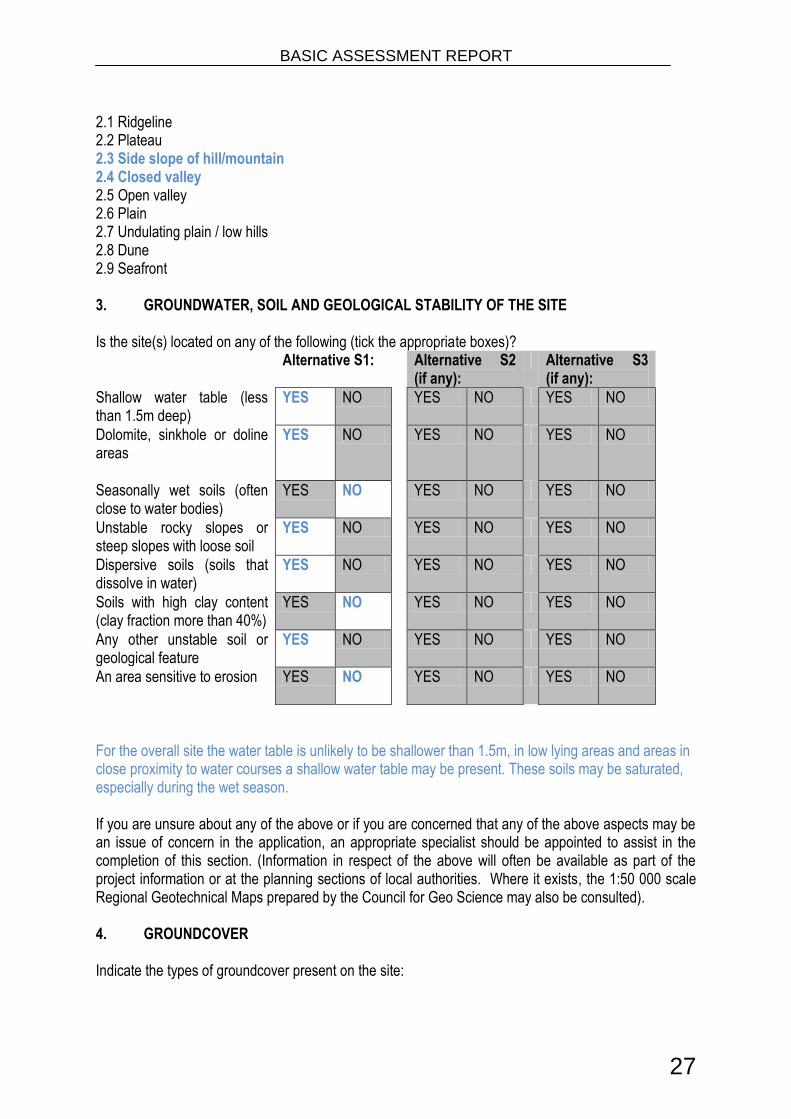
2.1 Ridgeline 2.2 Plateau 2.3 Side slope of hill/mountain 2.4 Closed valley 2.5 Open valley 2.6 Plain 2.7 Undulating plain / low hills 2.8 Dune 2.9 Seafront 3. GROUNDWATER, SOIL AND GEOLOGICAL STABILITY OF THE SITE Is the site(s) located on any of the following (tick the appropriate boxes)? Alternative S1: Alternative S2
(if any): Alternative S3
(if any):
Shallow water table (less than 1.5m deep)
YES NO YES NO YES NO
Dolomite, sinkhole or doline areas
YES NO YES NO YES NO
Seasonally wet soils (often close to water bodies)
YES NO YES NO YES NO
Unstable rocky slopes or steep slopes with loose soil
YES NO YES NO YES NO
Dispersive soils (soils that dissolve in water)
YES NO YES NO YES NO
Soils with high clay content (clay fraction more than 40%)
YES NO YES NO YES NO
Any other unstable soil or geological feature
YES NO YES NO YES NO
An area sensitive to erosion
YES NO YES NO YES NO
For the overall site the water table is unlikely to be shallower than 1.5m, in low lying areas and areas in close proximity to water courses a shallow water table may be present. These soils may be saturated, especially during the wet season. If you are unsure about any of the above or if you are concerned that any of the above aspects may be an issue of concern in the application, an appropriate specialist should be appointed to assist in the completion of this section. (Information in respect of the above will often be available as part of the project information or at the planning sections of local authorities. Where it exists, the 1:50 000 scale Regional Geotechnical Maps prepared by the Council for Geo Science may also be consulted). 4. GROUNDCOVER Indicate the types of groundcover present on the site:

BASIC ASSESSMENT REPORT
28
The location of all identified rare or endangered species or other elements should be accurately indicated on the site plan(s).
Natural veld - good conditionE
Natural veld with scattered aliensE
Natural veld with heavy alien infestationE
Veld dominated by alien speciesE
Gardens
Sport field Cultivated land
Paved surface Building or other structure
Bare soil
If any of the boxes marked with an ―E ―is ticked, please consult an appropriate specialist to assist in the completion of this section if the environmental assessment practitioner doesn‘t have the necessary expertise. 6. LAND USE CHARACTER OF SURROUNDING AREA Indicate land uses and/or prominent features that does currently occur within a 500m radius of the site and give description of how this influences the application or may be impacted upon by the application: 6.1 Natural area
The existing natural area is not developed. The footpaths currently exist and will therefore not alter the natural area, except to change the surface substance of the footpaths to a paved surface.
Construction methods will need to incorporate mitigation measures to reduce negative impacts on the receiving natural environment.
6.2 Low density residential 6.3 Medium density residential
Medium density residential areas neighbouring the project site will be impacted on by the proposed project in a positive way. The footpaths are an important route for most residents in the Tshelimnyama community to reach the nearby industrial area.
6.4 High density residential 5.5 Informal residentialA
5.6 Retail commercial & warehousing 5.7 Light industrial 5.8 Medium industrial AN 5.9 Heavy industrial AN 5.10 Power station 5.11 Office/consulting room 5.12 Military or police base/station/compound 5.13 Spoil heap or slimes damA 5.14 Quarry, sand or borrow pit 5.15 Dam or reservoir 5.16 Hospital/medical centre 5.17 School 5.18 Tertiary education facility 5.19 Church 5.20 Old age home 5.21 Sewage treatment plantA 5.22 Train station or shunting yard N 5.23 Railway line N
5.24 Major road (4 lanes or more) N

BASIC ASSESSMENT REPORT
29
The N3 Section 1 intersects the proposed project as the footpaths lead to the pedestrian bridge that will be constructed over the N3.
5.25 Airport N 5.26 Harbour 5.27 Sport facilities 5.28 Golf course 5.29 Polo fields 5.30 Filling station H
5.31 Landfill or waste treatment site 5.32 Plantation 5.33 Agriculture 5.34 River, stream or wetland
There are 5 river crossings associated with this application. 5.35 Nature conservation area 5.36 Mountain, koppie or ridge 5.37 Museum 5.38 Historical building 5.39 Protected Area 5.40 Graveyard 5.41 Archaeological site 5.42 Other land uses (describe) None identified. If any of the boxes marked with an ―N ―are ticked, how will this impact / be impacted upon by the proposed activity? The N3 Section 1 intersects the proposed project as the footpaths lead to the pedestrian bridge that will be constructed over the N3. If any of the boxes marked with an "An" are ticked, how will this impact / be impacted upon by the proposed activity?
If YES, specify and explain:
If YES, specify:
If any of the boxes marked with an "H" are ticked, how will this impact / be impacted upon by the proposed activity.
If YES, specify:
6. CULTURAL/HISTORICAL FEATURES
Are there any signs of culturally or historically significant elements, as defined in section 2 of the National Heritage Resources Act, 1999, (Act No. 25 of 1999), including
YES NO
Archaeological or palaeontological sites, on or close (within 20m) to the site?
Uncertain
If YES, explain:
If uncertain, conduct a specialist investigation by a recognised specialist in the field to establish whether there is such a feature(s) present on or close to the site.

BASIC ASSESSMENT REPORT
30
Briefly explain the findings of the specialist:
Will any building or structure older than 60 years be affected in any way? YES NO
Is it necessary to apply for a permit in terms of the National Heritage Resources Act, 1999 (Act 25 of 1999)?
YES NO
If yes, please submit or, make sure that the applicant or a specialist submits the necessary application to SAHRA or the relevant provincial heritage agency and attach proof thereof to this application if such application has been made.
SECTION C: PUBLIC PARTICIPATION 1. ADVERTISEMENT The person conducting a public participation process must take into account any guidelines applicable to public participation as contemplated in section 24J of the Act and must give notice to all potential interested and affected parties of the application which is subjected to public participation by— (a) fixing a notice board (of a size at least 60cm by 42cm; and must display the required
information in lettering and in a format as may be determined by the competent authority) at a place conspicuous to the public at the boundary or on the fence of— (i) the site where the activity to which the application relates is or is to be undertaken; and
(ii) any alternative site mentioned in the application; (b) giving written notice to—
(i) the owner or person in control of that land if the applicant is not the owner or person in control of the land;
(ii) the occupiers of the site where the activity is or is to be undertaken or to any alternative site where the activity is to be undertaken;
(iii) owners and occupiers of land adjacent to the site where the activity is or is to be undertaken or to any alternative site where the activity is to be undertaken;
(iv) the municipal councillor of the ward in which the site or alternative site is situated and any organisation of ratepayers that represent the community in the area;
(v) the municipality which has jurisdiction in the area; (vi) any organ of state having jurisdiction in respect of any aspect of the activity; and (vii) any other party as required by the competent authority;
(c) placing an advertisement in— (i) one local newspaper; or
(ii) any official Gazette that is published specifically for the purpose of providing public notice of applications or other submissions made in terms of these Regulations;
(d) placing an advertisement in at least one provincial newspaper or national newspaper, if the activity has or may have an impact that extends beyond the boundaries of the metropolitan or local municipality in which it is or will be undertaken: Provided that this paragraph need not be complied with if an advertisement has been placed in an official Gazette referred to in subregulation 54(c)(ii); and
(e) using reasonable alternative methods, as agreed to by the competent authority, in those instances where a person is desiring of but unable to participate in the process due to— (i) illiteracy; (ii) disability; or (iii) any other disadvantage.

BASIC ASSESSMENT REPORT
31
2. CONTENT OF ADVERTISEMENTS AND NOTICES A notice board, advertisement or notices must:
(a) indicate the details of the application which is subjected to public participation; and (b) state—
(i) that the application has been submitted to the competent authority in terms of these Regulations, as the case may be; (ii) whether basic assessment or scoping procedures are being applied to the
application, in the case of an application for environmental authorisation;
(iii) the nature and location of the activity to which the application relates; (iv) where further information on the application or activity can be obtained; and (iv) the manner in which and the person to whom representations in respect of the
application may be made. 3. PLACEMENT OF ADVERTISEMENTS AND NOTICES Where the proposed activity may have impacts that extend beyond the municipal area where it is located, a notice must be placed in at least one provincial newspaper or national newspaper, indicating that an application will be submitted to the competent authority in terms of these regulations, the nature and location of the activity, where further information on the proposed activity can be obtained and the manner in which representations in respect of the application can be made, unless a notice has been placed in any Gazette that is published specifically for the purpose of providing notice to the public of applications made in terms of the EIA regulations. Advertisements and notices must make provision for all alternatives. 4. DETERMINATION OF APPROPRIATE MEASURES The practitioner must ensure that the public participation is adequate and must determine whether a public meeting or any other additional measure is appropriate or not based on the particular nature of each case. Special attention should be given to the involvement of local community structures such as Ward Committees, ratepayers associations and traditional authorities where appropriate. Please note that public concerns that emerge at a later stage that should have been addressed may cause the competent authority to withdraw any authorisation it may have issued if it becomes apparent that the public participation process was inadequate.
5. COMMENTS AND RESPONSE REPORT The practitioner must record all comments and respond to each comment of the public before the application is submitted. The comments and responses must be captured in a comments and response report as prescribed in the EIA regulations and be attached to this application. The comments and response report must be attached under Appendix E. 6. AUTHORITY PARTICIPATION

BASIC ASSESSMENT REPORT
32
Please note that a complete list of all organs of state and or any other applicable authority with their contact details must be appended to the basic assessment report or scoping report, whichever is applicable. Authorities are key interested and affected parties in each application and no decision on any application will be made before the relevant local authority is provided with the opportunity to give input. List of authorities informed:
Authorities informed are:
KZN Department of Agriculture, Environmental Affairs & Rural Development (DAEARD)
Department of Water Affairs (DWA)
Ezemvelo KZN Wildlife (EKZNW)
eThekweni Municipality
Wildlife and Environment Society of South Africa (WESSA)
Amafa aKwaZulu-Natali (Amafa)
Ward Councillor
Department of Health
Department of Human Settlements
Department of Transport
Department of Agriculture, Forestry and Fisheries
List of authorities from whom comments have been received:
Received comments from :
Department of Transport
eThekwini Municipality
KZN Department of Human Settlements
WESSA

BASIC ASSESSMENT REPORT
33
7. CONSULTATION WITH OTHER STAKEHOLDERS Note that, for linear activities, or where deviation from the public participation requirements may be appropriate, the person conducting the public participation process may deviate from the requirements of that subregulation to the extent and in the manner as may be agreed to by the competent authority. Proof of any such agreement must be provided, where applicable.
Has any comment been received from stakeholders? YES NO
If ―YES‖, briefly describe the feedback below (also attach copies of any correspondence to and from the stakeholders to this application):
1. Department of Transport
“You are advised that the application is in the process of being investigated and that you will be advised accordingly of this Department‘s comments.‖
2. eThekwini Municipality
Health, Safety and Social Services
―This Department has no objection to the proposed development.‖
3. eThekwini Municipality
EThekwini Electricity Department ―The Electricity Department has no objection, however, please note:
1. The applicant must consult eThekwini Electricity‘s mains records (held in the drawing office at eThekwini Electricity Headquarters, 1 Jelf Taylor Crescent, for the presence of underground electrical services. In addition should any overhead line and/ or servitude be affected, the specific permission of the Head: Electricity must be sought regarding the development.
2. The relocation of MV/LV electrical services, if required in order to accommodate the development, will be carried out at the expense of the applicant.‖
Environmental Planning and Climate Protection Department ―It is noted that the proposed activity is on DMOSS. However, there is not sufficient information for a detailed comment to be provided at this stage. Comments will be provided when more information is provided in the Draft report.‖ Land Use Management Branch ―Please be advised that the Town Planning Section has no objections or concerns with the above mentioned report.‖ Framework Planning Branch ―The Framework Planning branch has reviewed the abovementioned application and submits the following comments:
There are no major objections in principle to the proposal as the proposed pedestrian facilities (crossings) appears to be necessary and will add a much needed benefit to the community by

BASIC ASSESSMENT REPORT
34
way of improved access to the adjacent industrial areas of employment. These proposed facilities will improve the overall pedestrian safety of residents who previously had no alternative but to cross the high speed N3 Highway and are therefore highly supported in this context. Concern is however raised regarding the floodlines which the crossings will traverse. It is therefore recommended that approval be sought both from the Environmental Management Branch and the Storm-water and Catchment Management Department.‖ Pavement and Geotechnical Engineering Branch ―Since the exact pathways are not shown, the comment is generic. Some of the slopes are moderately steep and long while the sandy soils are potentially moderately erodible. While it is expected that a paved pathway should cause less erosion than a foot path, the design should specifically bear this in mind.
The bridges or causeways at the river crossings must be properly founded, based on a geotechnical investigation.
No geotechnical objections at this stage.‖ eThekwini Transport Authority ―No objections to the proposed provision of pedestrian facilities on National Route 3 Section 1. However, cognizance is to be taken of the proposed developments in the vicinity of this area, to ensure the continuity of the pedestrian route.
In addition the proposal will need to be incorporated into the Non-Motorised Transport (NMT) plan being developed for eThekwini.‖ Coastal Stormwater and Catchment Management Department ―This Department would need to see the flood report for the proposed crossings.‖ eThekwini Water and Sanitation Department ―Tongaat Hulett is currently undertaking an EIA process that intends bringing a sewer down from Hillcrest which may or may not interfere with this proposal. The applicant is to ensure that there is no clash between the two EIA processes. In this regard please register this Department as an Interested and Affected Party, please contact John Harrison on 031-3118665.
Details of structure relating to position is not available. Existing sewer network needs to be protected and designs of footing and foundations must take existing services into account.‖
4. KZN Department of Human Settlements
―The construction of pedestrian footbridge is supported in view of the fact that it will provide safe crossing for the pedestrians and improving the lives of the local community. Kindly forward further reports to this office for attention of:- Mr P. Woolf Senior Manager: Planning and GIS Private Bag X54367 Durban 4000‖

BASIC ASSESSMENT REPORT
35
5. WESSA
―Thank you for the information relating to the proposed construction of pedestrian facilities at Tshelimnyama, N3 section 1, in the vicinity of the Mariannhill toll plaza. WESSA recognizes the need to formalize the crossings across the Mhlatuzana river and we trust that the proposed number of crossings (five) can be fully justified. With community consultation it may be more appropriate to consider consolidating existing pathways and so minimizing crossing points. Our interest in the project is the construction phase where there is the potential for further degradation of the riparian area and pollution, however, we are satisfied that compliance with a comprehensive environmental management programme will minimize potential impacts and we do not require further information. We appreciate the opportunity to comment.‖

BASIC ASSESSMENT REPORT
36
SECTION D: IMPACT ASSESSMENT The assessment of impacts must adhere to the minimum requirements in the EIA Regulations, 2010, and should take applicable official guidelines into account. The issues raised by interested and affected parties should also be addressed in the assessment of impacts. 1. ISSUES RAISED BY INTERESTED AND AFFECTED PARTIES List the main issues raised by interested and affected parties.
1. Department of Transport
“You are advised that the application is in the process of being investigated and that you will be advised accordingly of this Department‘s comments.‖
2. eThekwini Municipality
Health, Safety and Social Services
―This Department has no objection to the proposed development.‖
3. eThekwini Municipality
EThekwini Electricity Department ―The Electricity Department has no objection, however, please note:
1. The applicant must consult eThekwini Electricity‘s mains records (held in the drawing office at eThekwini Electricity Headquarters, 1 Jelf Taylor Crescent, for the presence of underground electrical services. In addition should any overhead line and/ or servitude be affected, the specific permission of the Head: Electricity must be sought regarding the development.
2. The relocation of MV/LV electrical services, if required in order to accommodate the development, will be carried out at the expense of the applicant.‖
Environmental Planning and Climate Protection Department ―It is noted that the proposed activity is on DMOSS. However, there is not sufficient information for a detailed comment to be provided at this stage. Comments will be provided when more information is provided in the Draft report.‖ Land Use Management Branch ―Please be advised that the Town Planning Section has no objections or concerns with the above mentioned report.‖ Framework Planning Branch ―The Framework Planning branch has reviewed the abovementioned application and submits the following comments:
There are no major objections in principle to the proposal as the proposed pedestrian facilities (crossings) appears to be necessary and will add a much needed benefit to the community by way of improved access to the adjacent industrial areas of employment. These proposed

BASIC ASSESSMENT REPORT
37
facilities will improve the overall pedestrian safety of residents who previously had no alternative but to cross the high speed N3 Highway and are therefore highly supported in this context. Concern is however raised regarding the floodlines which the crossings will traverse. It is therefore recommended that approval be sought both from the Environmental Management Branch and the Storm-water and Catchment Management Department.‖ Pavement and Geotechnical Engineering Branch ―Since the exact pathways are not shown, the comment is generic. Some of the slopes are moderately steep and long while the sandy soils are potentially moderately erodible. While it is expected that a paved pathway should cause less erosion than a foot path, the design should specifically bear this in mind.
The bridges or causeways at the river crossings must be properly founded, based on a geotechnical investigation.
No geotechnical objections at this stage.‖ eThekwini Transport Authority ―No objections to the proposed provision of pedestrian facilities on National Route 3 Section 1. However, cognizance is to be taken of the proposed developments in the vicinity of this area, to ensure the continuity of the pedestrian route.
In addition the proposal will need to be incorporated into the Non-Motorised Transport (NMT) plan being developed for eThekwini.‖ Coastal Stormwater and Catchment Management Department ―This Department would need to see the flood report for the proposed crossings.‖ eThekwini Water and Sanitation Department ―Tongaat Hulett is currently undertaking an EIA process that intends bringing a sewer down from Hillcrest which may or may not interfere with this proposal. The applicant is to ensure that there is no clash between the two EIA processes. In this regard please register this Department as an Interested and Affected Party, please contact John Harrison on 031-3118665.
Details of structure relating to position is not available. Existing sewer network needs to be protected and designs of footing and foundations must take existing services into account.‖
4. KZN Department of Human Settlements
―The construction of pedestrian footbridge is supported in view of the fact that it will provide safe crossing for the pedestrians and improving the lives of the local community. Kindly forward further reports to this office for attention of:- Mr P. Woolf Senior Manager: Planning and GIS Private Bag X54367 Durban 4000‖

BASIC ASSESSMENT REPORT
38
5. WESSA
―Thank you for the information relating to the proposed construction of pedestrian facilities at Tshelimnyama, N3 section 1, in the vicinity of the Mariannhill toll plaza. WESSA recognizes the need to formalize the crossings across the Mhlatuzana river and we trust that the proposed number of crossings (five) can be fully justified. With community consultation it may be more appropriate to consider consolidating existing pathways and so minimizing crossing points. Our interest in the project is the construction phase where there is the potential for further degradation of the riparian area and pollution, however, we are satisfied that compliance with a comprehensive environmental management programme will minimize potential impacts and we do not require further information. We appreciate the opportunity to comment.‖
Response from the practitioner to the issues raised by the interested and affected parties (A full response must be given in the Comments and Response Report that must be attached to this report as Annexure E):
1. Department of Transport
Comments noted. Awaiting further comment from the Department. 2. eThekwini Municipality
Health, Safety and Social Services Comments noted.
3. eThekwini Municipality
EThekwini Electricity Department Comments noted.
Environmental Planning and Climate Protection Department Comments noted.
Land Use Management Branch Comments noted.
Framework Planning Branch Your concern regarding the floodlines is noted. The river crossings have not been designed for any flood event, but rather this project is purely a formalization of existing footpath networks, which already cross the river at 5 particular points.
Pavement and Geotechnical Engineering Branch Your comments are noted. According to the design report, the following can be noted: ―Where the footpath encounters steep terrain towards Tshelimnyama Township, it is proposed that the maximum gradient of the footpath does not exceed 1:5. Where gradients

BASIC ASSESSMENT REPORT
39
steeper than 1:5 are encountered, it is proposed that the footpath incorporates stairs at 200mm rise vertically and a 1m step horizontally to ease the accent on the steep gradients.‖ A Geotechnical investigation has not been conducted, as it was not deemed necessary for the scope of this particular application; however the river crossings will be constructed according to design standards and will be sufficiently founded.
eThekwini Transport Authority The pedestrian routes that are being formalised were selected based on an analysis of the most frequently used pathways, as well as linking this up with the pedestrian bridge which is currently being constructed over the N3.
Coastal Stormwater and Catchment Management Department There is no flood report for the proposed crossings. The pedestrian pathways and associated river crossings are a formalisation of existing pathways and crossings.
eThekwini Water and Sanitation Department The applicable Environmental Assessment Practitioner (EAP) assigned to the Tongaat Hulett application has been contacted. We requested information on the footprint of their application and provided a layout of the project area for the proposed footpaths. We are awaiting further feedback from the EAP.
4. KZN Department of Human Settlements
Your comments are noted and will be included in the report. A draft copy of the Basic Assessment Report will be forwarded to your department.
5. WESSA
Your comments are noted. The project engineers have surveyed the various existing footpaths and the associated river crossings. These paths and five river crossings that have been considered for formalization are deemed necessary based on the excessive foot traffic along these routes. Public safety is also a concern as most of these crossings are relatively dangerous to cross in medium-flow events. The construction phase will be monitored by an independent Environmental Control Officer (ECO) according to the specifications of the Environmental Management Plan (EMP) specific to the project.
2. IMPACTS THAT MAY RESULT FROM THE PLANNING AND DESIGN, CONSTRUCTION, OPERATIONAL, DECOMMISSIONING AND CLOSURE PHASES AS WELL AS PROPOSED MANAGEMENT OF IDENTIFIED IMPACTS AND PROPOSED MITIGATION MEASURES List the potential direct, indirect and cumulative property/activity/design/technology/operational alternative related impacts (as appropriate) that are likely to occur as a result of the planning and design phase, construction phase, operational phase, decommissioning and closure phase, including

BASIC ASSESSMENT REPORT
40
impacts relating to the choice of site/activity/technology alternatives as well as the mitigation measures that may eliminate or reduce the potential impacts listed.
Preferred Technology Alternative (A1) The preferred activity alternative is based on the preferred technology type. No site alternative has been considered as the footpaths already exist and this application is based on the formalisation of these existing pathways. The preferred layout has been chosen based on the most frequented footpaths. The alternative considered is a technology alternative based on the retaining structures for these formalised footpaths.
Phase 1: Planning and Design Direct Impacts None Indirect Impacts None Cumulative Impacts No impacts were identified during the planning and design phase. Mitigation Measures No impacts to mitigate.
Phase 2: Construction Direct Impacts Topography Impacts to surface topography and drainage will occur as a result of the construction works associated with the formalisation of the footpaths and the temporary works in the river at the 5 river crossings. Soils During the construction phase, soils will be cleared for the footpaths and river crossings. Potential disturbances include compaction, physical removal and potential pollution by hydrocarbons. Furthermore, if standard stormwater control measures are not implemented during the construction phase, soil erosion and subsequent removal of vegetation may occur. Vegetation and fauna During the construction phase vegetation will be cleared for the construction of the concrete footpaths and the river crossings. Surface water Clearing of vegetation during the construction phase will increase surface runoff and therefore adequate stormwater measures will need to be implemented. Waste generated during the construction phase may enter the environment through surface water runoff. Litter or pollutants such as hydrocarbons may wash into the river system.

BASIC ASSESSMENT REPORT
41
Cultural and Historical Amafa aKwaZulu-Natali (Amafa) has been contacted and an application has been submitted for this project, however we have not received any correspondence. It is therefore presumable that a Heritage Impact Assessment is not required, until such notice is provided by Amafa. Standard mitigation measures as stipulated in the Environmental Management Plan (EMP) will be adopted. Visual The project involves formalisation of existing infrastructure, therefore the visual impact will be limited to the change in material of the footpath from gravel to concrete. Socio-Economic Construction in the area is expected to have a positive impact on the area and local community as it will provide some employment opportunities during the construction phase. Indirect Impacts Soils Insufficient stormwater control measures may result in eroded soil entering the river, resulting in increased siltation. Surface and Groundwater Contaminated water may negatively impact on the river system. Air quality During the construction phase, the operation of machinery and equipment, as well as the construction vehicle traffic will increase localised noise levels. Due to the location of the study area, the impact of noise created during the construction phase will be limited to the project area. The N3 is directly adjacent to the project site, and existing traffic noise volumes exceed any noise impact that will result from the construction of the footpaths. Therefore the ambient noise levels are unlikely to be impacted. Cumulative Impacts Topography Impacts to surface topography and drainage will occur as a result of the construction works associated with the formalisation of the footpaths and the temporary works in the river at the 5 river crossings. Soils During the construction phase, soils will be cleared for the footpaths and river crossings. Potential disturbances include compaction, physical removal and potential pollution by hydrocarbons. Furthermore, if standard stormwater control measures are not implemented during the construction phase, soil erosion and subsequent removal of vegetation may occur. Insufficient stormwater control measures may result in eroded soil entering the river, resulting in increased siltation. Vegetation and fauna During the construction phase vegetation will be cleared for the construction of the concrete

BASIC ASSESSMENT REPORT
42
footpaths and the river crossings. Surface water Clearing of vegetation during the construction phase will increase surface runoff and therefore adequate stormwater measures will need to be implemented. Waste generated during the construction phase may enter the environment through surface water runoff. Litter or pollutants such as hydrocarbons may wash into the river system. Air quality During the construction phase, the operation of machinery and equipment, as well as the construction vehicle traffic will increase localised noise levels. Due to the location of the study area, the impact of noise created during the construction phase will be limited to the project area. The N3 is directly adjacent to the project site, and existing traffic noise volumes exceed any noise impact that will result from the construction of the footpaths. Therefore the ambient noise levels are unlikely to be impacted. Cultural and Historical Amafa aKwaZulu-Natali (Amafa) has been contacted and an application has been submitted for this project, however we have not received any correspondence. It is therefore presumable that a Heritage Impact Assessment is not required, until such notice is provided by Amafa. Standard mitigation measures as stipulated in the Environmental Management Plan (EMP) will be adopted. Visual The project involves formalisation of existing infrastructure, therefore the visual impact will be limited to the change in material of the footpath from gravel to concrete. Socio-Economic Construction in the area is expected to have a positive impact on the area and local community as it will provide some employment opportunities during the construction phase. Surface and Groundwater Contaminated water may negatively impact on the river system. Mitigation Measures Topography
Temporary stormwater control measures should be installed in the event that rain should occur which has the potential to cause erosion of exposed soil;
Cut-off drains must be installed to facilitate the control of surface water runoff velocities;
Stormwater control barriers should be used to divert surface water runoff into grassland buffers and not directly into the exposed workings;
A stormwater management plan should be compiled during the detailed engineering design phase to ensure that adequate stormwater management measures are incorporated into the design of the surface infrastructure;
Stockpiles of soils and material should be located on high ground out of the reach of flood flows; and
Stockpiles will be sited in areas demarcated for such purposes prior to the commencement of construction activities.

BASIC ASSESSMENT REPORT
43
Soils
Spread absorbent material on areas where hydrocarbon spills occur;
Contaminated soils are to be removed to a contained storage area and disposed of at a licensed facility;
Soil should be stockpiled in such a way as to minimize erosion. Vegetation and Fauna
All construction areas should be demarcated prior to construction to ensure that the footprint of the impacts are limited (including areas where vehicles may traverse);
Reseed cleared areas with an indigenous seed mix to prevent soil erosion;
Hunting and/or fishing activities on site is prohibited. This includes the setting of traps, or the killing of any animal caught in construction works;
No animal, reptile or bird of any sort found on site may be killed. This specifically includes snakes or other animals considered potentially dangerous discovered on site. If such an animal is discovered on site an appropriately skilled person should be summoned to remove the animal from the site. Consideration should be given to selection and nomination of such a person prior to site establishment. If no-one is available, training should be provided to at least two site staff members.
Waste Management
Demarcated areas where waste can be safely contained and stored on a temporary basis during the construction phase should be established. When adequate volumes (not more than 1 month) have accumulated all waste is to be removed from site and disposed of at a licensed facility;
Waste is not to be buried on site;
Hydrocarbons should be stored in a bunded storage area;
All hazardous materials including paints, turpentine and thinners must be stored appropriately to prevent these contaminants from entering the environment;
Spill-sorb or similar type product must be used to absorb hydrocarbon spills in the event that such spills should occur;
Surface Water
Care must be taken to ensure that in removing vegetation adequate erosion control measures are implemented;
A stormwater management plan, including sufficient erosion-control measures, must be compiled in consultation with a suitably qualified environmental practitioner / control officer during the detailed design phase prior to the commencement of construction; and
The propagation of low-growing dense vegetation suitable for the habitat such as grasses, sedges or reeds is the best natural method to reduce erosion potential in sensitive areas.
In-stream water flow should not be hindered throughout the construction phase.
Groundwater
Ensure that any hydrocarbons spills are cleaned up as soon as possible;
Provide drip-trays for vehicles that leak hydrocarbons and fix these leaks off site immediately
Ensure that an appropriately stocked spill-kit is available at all times where hydro-carbon handling will be undertaken; and
Ensure that hazardous materials are stored on a lined surface and that water runoff from the area is contained.

BASIC ASSESSMENT REPORT
44
Air Quality
Heavy vehicles and machinery should be serviced regularly to minimise exhaust fume pollution;
Soil stockpiles will be located in areas to limit the erosive effects of the wind, which will limit dust;
Removal of vegetation will be avoided until such time as soil stripping is required, which will limit dust.
Water should be sprayed onto gravel roads when required;
Environmental friendly soil stabilisers may be used as additional measures to control dust on gravel roads and construction areas;
All equipment should be kept in good working order;
Equipment should be operated within its specifications and capacity and should not be overloaded;
All machinery/plant should be serviced and lubricated regularly to ensure a good working order;
Ensure that the potential noise source will conform to the South African Bureau of Standards recommended code of practice, SANS Code 0103:1983, so that it will not produce excessive or undesirable noise when it is released;
All the Contractors‘ equipment shall be fitted with effective exhaust silencers and shall comply with the South African Bureau of Standards recommended code of practice and the South African National Standard (SANS) Code 0103:1983, for construction plant noise generation
All the Contractors‘ vehicles shall be fitted with effective exhaust silencers and shall comply with Road Traffic Act (Act 29 of 1989) when any such vehicle is operated on a public road.
Cultural and Historical Amafa aKwaZulu-Natali (Amafa) has been contacted and an application has been submitted for this project, however we have not received any correspondence. It is therefore presumable that a Heritage Impact Assessment is not required, until such notice is provided by Amafa. Standard mitigation measures as stipulated in the Environmental Management Plan (EMP) will be adopted.
Monitoring The contractor must appoint an on-site Environmental Liaison Officer (ELO) who will manage the day to day compliance with the EMP. An independent Environmental Control Officer (ECO) must be appointed to conduct monthly site audits and monitoring of compliance to the EMP.
Phase 3: Operational Direct Impacts
1. Improved surface condition of the footpaths. 2. Longevity of the path quality. 3. Safer walking conditions as the current footpaths are deeply eroded in many areas. The
formalisation of these paths will eliminate dongas and gullies on the walking surface. 4. General upliftment of the community. Surface water Operational phase will continue as before construction, however the larger surface area will

BASIC ASSESSMENT REPORT
45
increase surface water runoff. Stormwater infrastructure must be designed to adequately control this. Indirect Impacts None identified. Cumulative Impacts 1. Improved surface condition of the footpaths. 2. Longevity of the path quality. 3. Safer walking conditions as the current footpaths are deeply eroded in many areas. The
formalisation of these paths will eliminate dongas and gullies on the walking surface. 4. General upliftment of the community. Surface water Operational phase will continue as before construction, however the larger surface area will increase surface water runoff. Stormwater infrastructure must be designed to adequately control this. Mitigation Measures Surface water
Adequate stormwater management controls must be implemented to avoid contamination of surface water by hydrocarbons during construction.
Phase 4: Decommission The pedestrian pathways will not be decommissioned. Direct Impacts None Indirect Impacts None Cumulative Impacts None Mitigation Measures None
Technology Alternative (A2) The alternative considered is based on an alternate technology type. No site alternative has been considered as the footpaths already exist and this application is based on the formalisation of these existing pathways. The preferred layout has been chosen based on the most frequented footpaths. The technology alternative considered is based on the following details provided by the project engineers:

BASIC ASSESSMENT REPORT
46
Phase 1: Planning and Design Direct Impacts None Indirect Impacts None Cumulative Impacts No impacts were identified during the planning and design phase. Mitigation Measures No impacts to mitigate.
Phase 2: Construction Direct Impacts Topography Impacts to surface topography and drainage will occur as a result of the construction works associated with the formalisation of the footpaths and the temporary works in the river at the 5 river crossings. Soils During the construction phase, soils will be cleared for the footpaths and river crossings. Potential disturbances include compaction, physical removal and potential pollution by hydrocarbons. Furthermore, if standard stormwater control measures are not implemented during the construction phase, soil erosion and subsequent removal of vegetation may occur. Vegetation and fauna During the construction phase vegetation will be cleared for the construction of the concrete footpaths and the river crossings. Surface water Clearing of vegetation during the construction phase will increase surface runoff and therefore adequate stormwater measures will need to be implemented. Waste generated during the construction phase may enter the environment through surface water runoff. Litter or pollutants such as hydrocarbons may wash into the river system. Cultural and Historical Amafa aKwaZulu-Natali (Amafa) has been contacted and an application has been submitted for this project, however we have not received any correspondence. It is therefore presumable that a Heritage Impact Assessment is not required, until such notice is provided by Amafa. Standard mitigation measures as stipulated in the Environmental Management Plan (EMP) will be adopted. Visual The project involves formalisation of existing infrastructure, therefore the visual impact will be

BASIC ASSESSMENT REPORT
47
limited to the change in material of the footpath from gravel to concrete. Socio-Economic Construction in the area is expected to have a positive impact on the area and local community as it will provide some employment opportunities during the construction phase. Indirect Impacts Soils Insufficient stormwater control measures may result in eroded soil entering the river, resulting in increased siltation. Surface and Groundwater Contaminated water may negatively impact on the river system. Air quality During the construction phase, the operation of machinery and equipment, as well as the construction vehicle traffic will increase localised noise levels. Due to the location of the study area, the impact of noise created during the construction phase will be limited to the project area. The N3 is directly adjacent to the project site, and existing traffic noise volumes exceed any noise impact that will result from the construction of the footpaths. Therefore the ambient noise levels are unlikely to be impacted. Cumulative Impacts Topography Impacts to surface topography and drainage will occur as a result of the construction works associated with the formalisation of the footpaths and the temporary works in the river at the 5 river crossings. Soils During the construction phase, soils will be cleared for the footpaths and river crossings. Potential disturbances include compaction, physical removal and potential pollution by hydrocarbons. Furthermore, if standard stormwater control measures are not implemented during the construction phase, soil erosion and subsequent removal of vegetation may occur. Insufficient stormwater control measures may result in eroded soil entering the river, resulting in increased siltation. Vegetation and fauna During the construction phase vegetation will be cleared for the construction of the concrete footpaths and the river crossings. Surface water Clearing of vegetation during the construction phase will increase surface runoff and therefore adequate stormwater measures will need to be implemented. Waste generated during the construction phase may enter the environment through surface water runoff. Litter or pollutants such as hydrocarbons may wash into the river system. Air quality During the construction phase, the operation of machinery and equipment, as well as the

BASIC ASSESSMENT REPORT
48
construction vehicle traffic will increase localised noise levels. Due to the location of the study area, the impact of noise created during the construction phase will be limited to the project area. The N3 is directly adjacent to the project site, and existing traffic noise volumes exceed any noise impact that will result from the construction of the footpaths. Therefore the ambient noise levels are unlikely to be impacted. Cultural and Historical Amafa aKwaZulu-Natali (Amafa) has been contacted and an application has been submitted for this project, however we have not received any correspondence. It is therefore presumable that a Heritage Impact Assessment is not required, until such notice is provided by Amafa. Standard mitigation measures as stipulated in the Environmental Management Plan (EMP) will be adopted. Visual The project involves formalisation of existing infrastructure, therefore the visual impact will be limited to the change in material of the footpath from gravel to concrete. Socio-Economic Construction in the area is expected to have a positive impact on the area and local community as it will provide some employment opportunities during the construction phase. Surface and Groundwater Contaminated water may negatively impact on the river system. Mitigation Measures Topography
Temporary stormwater control measures should be installed in the event that rain should occur which has the potential to cause erosion of exposed soil;
Cut-off drains must be installed to facilitate the control of surface water runoff velocities;
Stormwater control barriers should be used to divert surface water runoff into grassland buffers and not directly into the exposed workings;
A stormwater management plan should be compiled during the detailed engineering design phase to ensure that adequate stormwater management measures are incorporated into the design of the surface infrastructure;
Stockpiles of soils and material should be located on high ground out of the reach of flood flows; and
Stockpiles will be sited in areas demarcated for such purposes prior to the commencement of construction activities.
Soils
Spread absorbent material on areas where hydrocarbon spills occur;
Contaminated soils are to be removed to a contained storage area and disposed of at a licensed facility;
Soil should be stockpiled in such a way as to minimize erosion. Vegetation and Fauna
All construction areas should be demarcated prior to construction to ensure that the footprint of the impacts are limited (including areas where vehicles may traverse);

BASIC ASSESSMENT REPORT
49
Reseed cleared areas with an indigenous seed mix to prevent soil erosion;
Hunting and/or fishing activities on site is prohibited. This includes the setting of traps, or the killing of any animal caught in construction works;
No animal, reptile or bird of any sort found on site may be killed. This specifically includes snakes or other animals considered potentially dangerous discovered on site. If such an animal is discovered on site an appropriately skilled person should be summoned to remove the animal from the site. Consideration should be given to selection and nomination of such a person prior to site establishment. If no-one is available, training should be provided to at least two site staff members.
Waste Management
Demarcated areas where waste can be safely contained and stored on a temporary basis during the construction phase should be established. When adequate volumes (not more than 1 month) have accumulated all waste is to be removed from site and disposed of at a licensed facility;
Waste is not to be buried on site;
Hydrocarbons should be stored in a bunded storage area;
All hazardous materials including paints, turpentine and thinners must be stored appropriately to prevent these contaminants from entering the environment;
Spill-sorb or similar type product must be used to absorb hydrocarbon spills in the event that such spills should occur;
Surface Water
Care must be taken to ensure that in removing vegetation adequate erosion control measures are implemented;
A stormwater management plan, including sufficient erosion-control measures, must be compiled in consultation with a suitably qualified environmental practitioner / control officer during the detailed design phase prior to the commencement of construction; and
The propagation of low-growing dense vegetation suitable for the habitat such as grasses, sedges or reeds is the best natural method to reduce erosion potential in sensitive areas.
In-stream water flow should not be hindered throughout the construction phase.
Groundwater
Ensure that any hydrocarbons spills are cleaned up as soon as possible;
Provide drip-trays for vehicles that leak hydrocarbons and fix these leaks off site immediately
Ensure that an appropriately stocked spill-kit is available at all times where hydro-carbon handling will be undertaken; and
Ensure that hazardous materials are stored on a lined surface and that water runoff from the area is contained.
Air Quality
Heavy vehicles and machinery should be serviced regularly to minimise exhaust fume pollution;
Soil stockpiles will be located in areas to limit the erosive effects of the wind, which will limit dust;
Removal of vegetation will be avoided until such time as soil stripping is required, which will limit dust.
Water should be sprayed onto gravel roads when required;

BASIC ASSESSMENT REPORT
50
Environmental friendly soil stabilisers may be used as additional measures to control dust on gravel roads and construction areas;
All equipment should be kept in good working order;
Equipment should be operated within its specifications and capacity and should not be overloaded;
All machinery/plant should be serviced and lubricated regularly to ensure a good working order;
Ensure that the potential noise source will conform to the South African Bureau of Standards recommended code of practice, SANS Code 0103:1983, so that it will not produce excessive or undesirable noise when it is released;
All the Contractors‘ equipment shall be fitted with effective exhaust silencers and shall comply with the South African Bureau of Standards recommended code of practice and the South African National Standard (SANS) Code 0103:1983, for construction plant noise generation
All the Contractors‘ vehicles shall be fitted with effective exhaust silencers and shall comply with Road Traffic Act (Act 29 of 1989) when any such vehicle is operated on a public road.
Cultural and Historical Amafa aKwaZulu-Natali (Amafa) has been contacted and an application has been submitted for this project, however we have not received any correspondence. It is therefore presumable that a Heritage Impact Assessment is not required, until such notice is provided by Amafa. Standard mitigation measures as stipulated in the Environmental Management Plan (EMP) will be adopted.
Monitoring The contractor must appoint an on-site Environmental Liaison Officer (ELO) who will manage the day to day compliance with the EMP. An independent Environmental Control Officer (ECO) must be appointed to conduct monthly site audits and monitoring of compliance to the EMP.
Phase 3: Operational Direct Impacts
5. Improved surface condition of the footpaths. 6. Longevity of the path quality. 7. Safer walking conditions as the current footpaths are deeply eroded in many areas. The
formalisation of these paths will eliminate dongas and gullies on the walking surface. 8. General upliftment of the community. Surface water Operational phase will continue as before construction, however the larger surface area will increase surface water runoff. Stormwater infrastructure must be designed to adequately control this. Indirect Impacts None identified. Cumulative Impacts

BASIC ASSESSMENT REPORT
51
5. Improved surface condition of the footpaths. 6. Longevity of the path quality. 7. Safer walking conditions as the current footpaths are deeply eroded in many areas. The
formalisation of these paths will eliminate dongas and gullies on the walking surface. 8. General upliftment of the community. Surface water Operational phase will continue as before construction, however the larger surface area will increase surface water runoff. Stormwater infrastructure must be designed to adequately control this. Mitigation Measures Surface water
Adequate stormwater management controls must be implemented to avoid contamination of surface water by hydrocarbons during construction.
Phase 4: Decommission The pedestrian pathways will not be decommissioned. Direct Impacts None Indirect Impacts None Cumulative Impacts None Mitigation Measures None
No-go Alternative (A3) Direct Impacts
The poor state of the pedestrian footpaths would continue.
The erosion caused by runoff down these footpaths would continue.
The footpaths are currently utilised by motorbike riders and this is adding to the poor condition of these paths. Hence the formalisation of the paths would ensure that the paths keep their form, even if the riders continue to use the footpaths.
No changes to current natural environment.
Indirect Impacts
Loss of potential income for local residents and Contractor due to the project not going ahead.
Increased runoff and impacts to water quality of the river system through suspended

BASIC ASSESSMENT REPORT
52
sediment. Cumulative Impacts
The poor state of the pedestrian footpaths would continue.
The erosion caused by runoff down these footpaths would continue.
The footpaths are currently utilised by motorbike riders and this is adding to the poor condition of these paths. Hence the formalisation of the paths would ensure that the paths keep their form, even if the riders continue to use the footpaths.
Loss of potential income for local residents and Contractor due to the project not going ahead.
No changes to current natural environment.
Increased runoff and impacts to water quality of the river system through suspended sediment.
Mitigation Measures Mitigation measures for the No-go alternative would be to go ahead with the proposed upgrade.
3. ENVIRONMENTAL IMPACT STATEMENT Taking the assessment of potential impacts into account, please provide an environmental impact statement that summarises the impact that the proposed activity and its alternatives may have on the environment after the management and mitigation of impacts have been taken into account, with specific reference to types of impact, duration of impacts, likelihood of potential impacts actually occurring and the significance of impacts.
The impacts related to the formalisation of the pedestrian footpaths will mainly occur during the construction phase of the activity. All these impacts can be mitigated as described in the document above. Furthermore, detailed mitigation and management principles for the construction phase will be included in the Environmental Management Programme (EMP). The proposed activity will have no significant negative impact on the receiving environment if the mitigation measures and management of the impacts (particularly during the construction phase) are undertaken. Most of the negative impacts are expected to be of low significance and short duration. Most of the negative impacts are unlikely, or if they are likely to occur, will still have a low risk rating for the receiving environment. It is imperative that an approved EMP be in place for the construction activities as well as the decommissioning of the contractor‘s camp. An independent ECO should be appointed to enforce EMP compliance. Areas that may be of concern are vegetation and fauna, surface water and groundwater, soils and air quality. However, with the correct implementation of the prescribed mitigation measures, these impacts can be kept to a minimum. The social impact will be of high significance to the local and wider community in a positive way. This is a positive outcome of the project. In the light of the impending need for improving the current access routes for these pedestrians; the impacts identified herein; the successful mitigation of these impacts; and the possible positive impacts that might be forthcoming from the activity, it is our opinion that there are no fatal flaws associated with the project that should prevent it from receiving

BASIC ASSESSMENT REPORT
53
environmental approval.
Alternative A (preferred alternative)
Technology alternative A, is the preferred alternative based on the use of RocEnviro Wall retaining structures for cuttings associated with the footpaths. This method is both quick and easy to construct as it involves precast moulded blocks, which form an effective retaining wall. Therefore the construction time may be reduced, limiting prolonged environmental impacts. This technology type also supports a variety of embankment heights and is therefore adaptable. The laying of these precast blocks can be either with open or closed joints. It is suggested that the method implemented in this particular instance be closed joints. This will limit vegetation growth between the blocks, which is likely to be alien invasive vegetation types, and will limit maintenance post-construction.
No-go alternative (compulsory)
It is not recommended that the No-go alternative be adopted, for the following reasons:
The poor state of the pedestrian footpaths would continue.
The erosion caused by runoff down these footpaths would continue.
The footpaths are currently utilised by motorbike riders and this is adding to the poor condition of these paths. Hence the formalisation of the paths would ensure that the paths keep their form, even if the riders continue to use the footpaths.
Loss of potential income for local residents and Contractor due to the project not going ahead.
No changes to current natural environment.
Increased runoff and impacts to water quality of the river system through suspended sediment.
Furthermore, should the No-go alternative stand, the Tshelimnyama community would continue to make use of the existing footpaths in their current condition. These paths are believed to be inadequate considering they are a primary route for most residents that do not utilise vehicular transport.

BASIC ASSESSMENT REPORT
54
SECTION E. RECOMMENDATION OF PRACTITIONER
Is the information contained in this report and the documentation attached hereto sufficient to make a decision in respect of the activity applied for (in the view of the environmental assessment practitioner)?
YES NO
If ―NO‖, indicate the aspects that should be assessed further as part of a Scoping and EIA process before a decision can be made (list the aspects that require further assessment):
If ―YES‖, please list any recommended conditions, including mitigation measures that should be considered for inclusion in any authorisation that may be granted by the competent authority in respect of the application:
It is recommended that the Preferred alternative (A1) be authorized. The authorization should include the following provisions:
An EMP must be compiled for the Site Establishment and Construction phases, prior to the contractor moving on site.
The appointment of an Environmental Liaison Officer (ELO) for day to day environmental management and an independent Environmental Control Officer (ECO) to complete monthly compliance audits of the EMP for the duration of the construction phase.
The ECO should be appointed prior to site establishment to prevent contravention of the EMP and Environmental Authorisation during the Site Establishment Phase and before the Construction Phase.
Is an EMP attached? YES NO
The EMP must be attached as Appendix F.

BASIC ASSESSMENT REPORT
55
SECTION F: APPENDIXES The following appendixes must be attached as appropriate: Appendix A: Site plan(s) Appendix B: Photographs Appendix C: Facility illustration(s) Appendix D: Specialist reports Appendix E: Comments and responses report Appendix F: Environmental Management Plan (EMP) Appendix G: Other information


![Materials Technology for Environmentally Green Micro ...lsi.usp.br/~acseabra/grad/2613_files/[4] Materials Technology for... · Materials Technology for Environmentally Green](https://img.pdfslide.us/doc/110x75/5b14f03d7f8b9a294c8cdbae/materials-technology-for-environmentally-green-micro-lsiuspbracseabragrad2613files4.jpg)