Embed Size (px)
Citation preview
Aviation Weather Hazards Nowcasting Based on Remote Temperature Sensing
Data
Mikhail Kanevsky*, Evgeny Miller**, Nikolay Baranov*** *International Aeronavigation Systems, [email protected],
**RPO ATTEX, [email protected],
***Dorodnicyn Computing Centre, FRC CSC RAS
2(30)
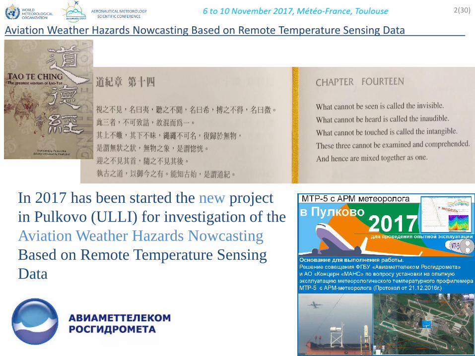
In 2017 has been started the new project
in Pulkovo (ULLI) for investigation of the
Aviation Weather Hazards Nowcasting
Based on Remote Temperature Sensing
Data
Aviation Weather Hazards Nowcasting Based on Remote Temperature Sensing Data .
San Francisco, USA, 2014
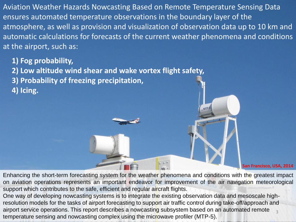
Enhancing the short-term forecasting system for the weather phenomena and conditions with the greatest impact
on aviation operations represents an important endeavor for improvement of the air navigation meteorological
support which contributes to the safe, efficient and regular aircraft flights.
One way of developing nowcasting systems is to integrate the existing observation data and mesoscale high-
resolution models for the tasks of airport forecasting to support air traffic control during take-off/approach and
airport service operations. This report describes a nowcasting subsystem based on an automated remote
temperature sensing and nowcasting complex using the microwave profiler (MTP-5).
Aviation Weather Hazards Nowcasting Based on Remote Temperature Sensing Data ensures automated temperature observations in the boundary layer of the atmosphere, as well as provision and visualization of observation data up to 10 km and automatic calculations for forecasts of the current weather phenomena and conditions at the airport, such as:
1) Fog probability, 2) Low altitude wind shear and wake vortex flight safety, 3) Probability of freezing precipitation, 4) Icing.
3

1. Introduction
4(30)
Aviation Weather Hazards Nowcasting Based on Remote Temperature Sensing Data .
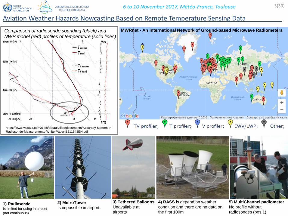
5) MultiChannel padiometer
No profile without
radiosondes (pos.1)
MWRnet - An International Network of Ground-based Microwave Radiometers
https://www.vaisala.com/sites/default/files/documents/Accuracy-Matters-in-
Radiosonde-Measurements-White-Paper-B211548EN.pdf
Comparison of radiosonde sounding (black) and
NWP model (red) profiles of temperature (solid lines)
1) Radiosonde Is limited for using in airport
(not continuous)
2) MetroTower
Is impossible in airport
3) Tethered Balloons
Unavailable at
airports
4) RASS is depend on weather
condition and there are no data on
the first 100m
5(30)
Aviation Weather Hazards Nowcasting Based on Remote Temperature Sensing Data .
6(30)
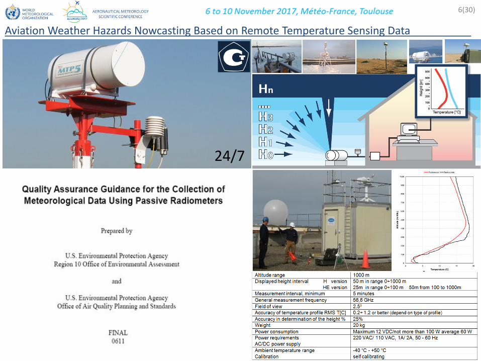
Aviation Weather Hazards Nowcasting Based on Remote Temperature Sensing Data .
24/7

Boulder 1996-7 300м Obninsk 1999 300м
Tsukuba 1994-5 и 2005 213м
7(30)
Aviation Weather Hazards Nowcasting Based on Remote Temperature Sensing Data .

8(30)
Aviation Weather Hazards Nowcasting Based on Remote Temperature Sensing Data .
25 years experience

Parma Italy 1995,1997 Zurich Swiss 2004 Pert Australia 2009 Rome Italy 2009 Begishevo Russia 2008 Bolzano Italy 2011
JFK USA 2012 Tomsk Russia 2012 Sochi Russia 2014 Tolmachevo 2014
SFO USA 2015 LAX USA 2015 IANS 2015
NASA Memphis IA 2013
Pulkovo (ULLI) 2017
10(30)
Aviation Weather Hazards Nowcasting Based on Remote Temperature Sensing Data .
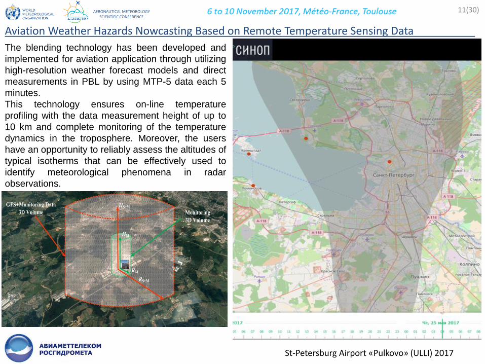
The blending technology has been developed and
implemented for aviation application through utilizing
high-resolution weather forecast models and direct
measurements in PBL by using MTP-5 data each 5
minutes.
This technology ensures on-line temperature
profiling with the data measurement height of up to
10 km and complete monitoring of the temperature
dynamics in the troposphere. Moreover, the users
have an opportunity to reliably assess the altitudes of
typical isotherms that can be effectively used to
identify meteorological phenomena in radar
observations.
11(30)
Aviation Weather Hazards Nowcasting Based on Remote Temperature Sensing Data .
St-Petersburg Airport «Pulkovo» (ULLI) 2017

Example of the temperature field up to 10 km (with a part up to 1 km) resulting from blending MTP-5 data and
GFS data measured on April 29-30, 2017, when advection was present, and, as a result, fog has been observed.
1) Fog probability,
2) Low altitude wind shear and wake vortex flight safety,
3) Probability of freezing precipitation,
4) Icing.
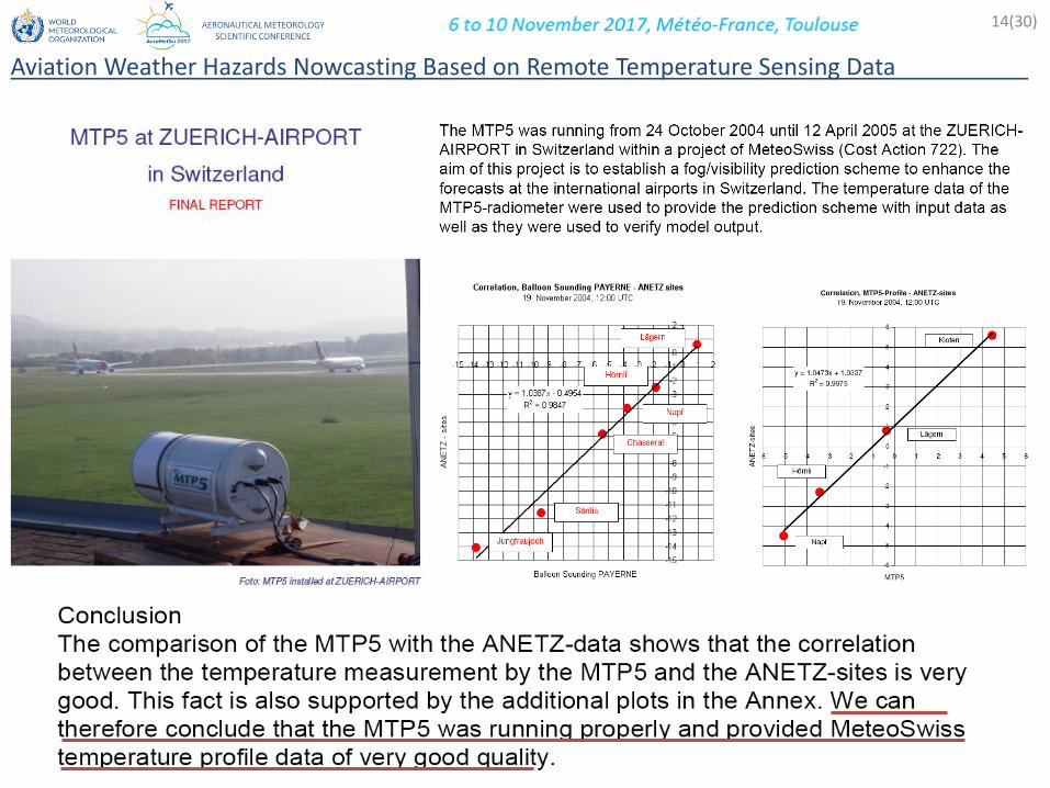
14(30)
Aviation Weather Hazards Nowcasting Based on Remote Temperature Sensing Data .
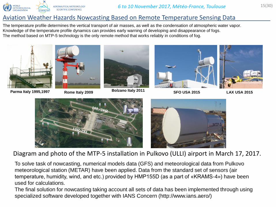
The temperature profile determines the vertical transport of air masses, as well as the condensation of atmospheric water vapor.
Knowledge of the temperature profile dynamics can provides early warning of developing and disappearance of fogs.
The method based on MTP-5 technology is the only remote method that works reliably in conditions of fog.
Parma Italy 1995,1997 Rome Italy 2009 Bolzano Italy 2011
SFO USA 2015 LAX USA 2015
Diagram and photo of the MTP-5 installation in Pulkovo (ULLI) airport in March 17, 2017.
To solve task of nowcasting, numerical models data (GFS) and meteorological data from Pulkovo
meteorological station (METAR) have been applied. Data from the standard set of sensors (air
temperature, humidity, wind, and etc.) provided by НМР155D (as a part of «KRAMS-4») have been
used for calculations.
The final solution for nowcasting taking account all sets of data has been implemented through using
specialized software developed together with IANS Concern (http://www.ians.aero/)
15(30)
Aviation Weather Hazards Nowcasting Based on Remote Temperature Sensing Data .
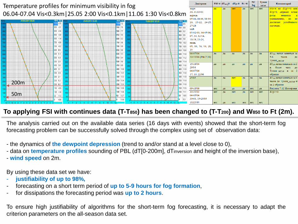
Temperature profiles for minimum visibility in fog 06.04-07.04 Vis<0.3km|25.05 2:00 Vis<0.1km|11.06 1:30 Vis<0.8km
The analysis carried out on the available data series (16 days with events) showed that the short-term fog
forecasting problem can be successfully solved through the complex using set of observation data:
- the dynamics of the dewpoint depression (trend to and/or stand at a level close to 0),
- data on temperature profiles sounding of PBL (dT[0-200m], dTinversion and height of the inversion base),
- wind speed on 2m.
By using these data set we have:
- justifiability of up to 98%,
- forecasting on a short term period of up to 5-9 hours for fog formation,
- for dissipations the forecasting period was up to 2 hours.
To ensure high justifiability of algorithms for the short-term fog forecasting, it is necessary to adapt the
criterion parameters on the all-season data set.
To applying FSI with continues data (T-T850) has been changed to (T-T200) and W850 to Ft (2m).
200m
50m

1) Fog probability,
2) Low altitude wind shear and wake vortex flight safety,
3) Probability of freezing precipitation,
4) Icing.
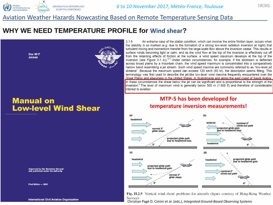
WHY WE NEED TEMPERATURE PROFILE for Wind shear?
Christian Pagé D. Cimini et al. (eds.), Integrated Ground-Based Observing Systems
MTP-5 has been developed for temperature inversion measurements!
18(30)
Aviation Weather Hazards Nowcasting Based on Remote Temperature Sensing Data .
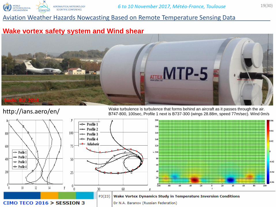
Sochi. RU. 2014
0 30 60 90 z0
25
50
75
100
125 y
Profile 1
Profile 2
Profile 3
Profile 4
Adiabatic
Wake turbulence is turbulence that forms behind an aircraft as it passes through the air.
В747-800, 100sec, Profile 1 next is B737-300 (wings 28.88m, speed 77m/sec). Wind 0m/s http://ians.aero/en/
Wake vortex safety system and Wind shear
19(30)
Aviation Weather Hazards Nowcasting Based on Remote Temperature Sensing Data .
8 10 12 14 16 T0
200
400
600
800
1000 h
Profile 1
Profile 2
Profile 3
Profile 4
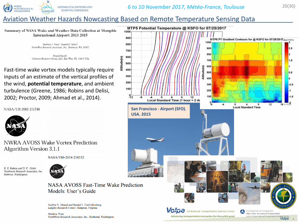
Fast-time wake vortex models typically require inputs of an estimate of the vertical profiles of the wind, potential temperature, and ambient turbulence (Greene, 1986; Robins and Delisi, 2002; Proctor, 2009; Ahmad et al., 2014).
20(30)
Aviation Weather Hazards Nowcasting Based on Remote Temperature Sensing Data .
San Francisco - Airport (SFO). USA. 2015
1) Fog probability,
2) Low altitude wind shear and wake vortex flight safety,
3) Probability of freezing precipitation,
4) Icing.
21
22(30)
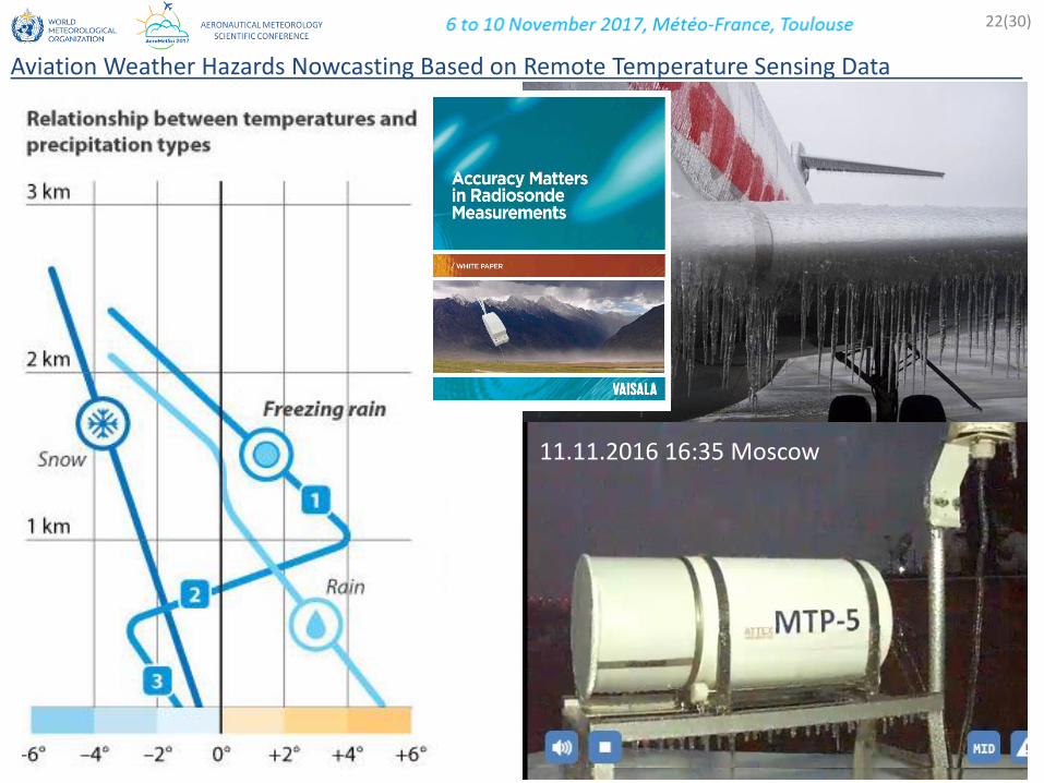
Aviation Weather Hazards Nowcasting Based on Remote Temperature Sensing Data .
11.11.2016 16:35 Moscow
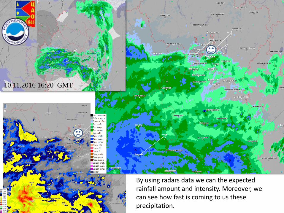
10.11.2016 16:20 GMT
By using radars data we can the expected rainfall amount and intensity. Moreover, we can see how fast is coming to us these precipitation.

dTo=To_isot-Tinv
1) Fog probability,
2) Low altitude wind shear and wake vortex flight safety,
3) Probability of freezing precipitation,
4) Icing.
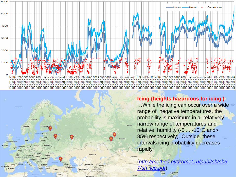
Icing (heights hazardous for icing )
…While the icing can occur over a wide
range of negative temperatures, the
probability is maximum in a relatively
narrow range of temperatures and
relative humidity (-5 ... -10°C and>
85% respectively). Outside these
intervals icing probability decreases
rapidly.
(http://method.hydromet.ru/publ/sb/sb3
7/sh_ice.pdf)

• Icing (+ weather forecast + meteorological data)
27(30)
Aviation Weather Hazards Nowcasting Based on Remote Temperature Sensing Data .

INVISIBLE WATER «Orlovka» 2015/01/22 09:43
Icing (heights hazardous for icing )
…While the icing can occur over a wide range of
negative temperatures, the probability is maximum in a
relatively narrow range of temperatures and relative
humidity (-5 ... -10°C and> 85% respectively). Outside
these intervals icing probability decreases rapidly.
(http://method.hydromet.ru/publ/sb/sb37/sh_ice.pdf)
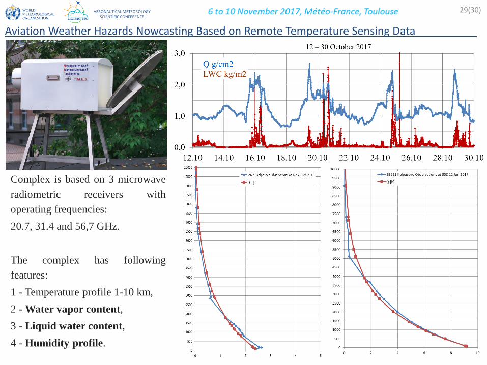
Complex is based on 3 microwave
radiometric receivers with
operating frequencies:
20.7, 31.4 and 56,7 GHz.
The complex has following
features:
1 - Temperature profile 1-10 km,
2 - Water vapor content,
3 - Liquid water content,
4 - Humidity profile.
29(30)
Aviation Weather Hazards Nowcasting Based on Remote Temperature Sensing Data .

Conclusions.
• The first step shown the good potential of the blending data NWP, in-situ data and state-of-
the-art remote sensing of the temperature stratification in solving task of the Aviation
Weather Hazards Nowcasting;
• By using the tested algorithms have been solved problem with limitation NWP in accuracy
in PBL and with height for temperature profiling at 56.6GHz (1 km usually),
• On the base of such implementation the NEW algorithms have been tested for Nowcasting:
1) Fog probability,
2) Low altitude wind shear and wake vortex flight safety,
3) Probability of freezing precipitation,
4) In-flight Icing
• To confirm and develop these results the work will be continue with development of user-
friendly software, hardware and testing in local airports.
tobecontinue…
30(30)
Aviation Weather Hazards Nowcasting Based on Remote Temperature Sensing Data .
Thank you
I wanted to thank everybody who is involved in this project. Merci beaucoup!
Evgeny Miller, Mikhail Kanevsky, Nikolay Baranov