Embed Size (px)
Citation preview
NOWCASTING OF PRECIPITATION
Isztar Zawadzki*
McGill University, Montreal, Canada
1. INTRODUCTION
Short-term methods of precipitation
nowcasting range from the simple use of
regional numerical forecasts to complex radar
data assimilation schemes. Presently, the
skill of numerical models is rather poor for
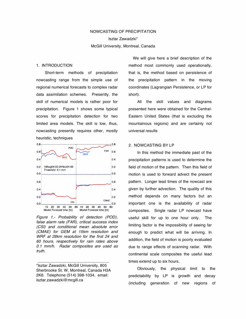
precipitation. Figure 1 shows some typical
scores for precipitation detection for two
limited area models. The skill is low, thus,
nowcasting presently requires other, mostly
heuristic, techniques
Figure 1.- Probability of detection (POD), false alarm rate (FAR), critical success index (CSI) and conditional mean absolute error (CMAE) for GEM at 15km resolution and WRF at 28km resolution for the first 24 and 60 hours, respectively for rain rates above 0.1 mm/h. Radar composites are used as truth. ________________________________
*Isztar Zawadzki, McGill University, 805 Sherbrooke St. W, Montreal, Canada H3A 2K6. Telephone (514) 398-1034, email: [email protected]
We will give here a brief description of the
method most commonly used operationally,
that is, the method based on persistence of
the precipitation pattern in the moving
coordinates (Lagrangian Persistence, or LP for
short).
All the skill values and diagrams
presented here were obtained for the Central-
Eastern United States (that is excluding the
mountainous regions) and are certainly not
universal results
2. NOWCASTING BY LP
In this method the immediate past of the
precipitation patterns is used to determine the
field of motion of the pattern. Then this field of
motion is used to forward advect the present
pattern. Longer lead times of the nowcast are
given by further advection. The quality of this
method depends on many factors but an
important one is the availability of radar
composites. Single radar LP nowcast have
useful skill for up to one hour only. The
limiting factor is the impossibility of seeing far
enough to predict what will be arriving. In
addition, the field of motion is poorly evaluated
due to range effects of scanning radar. With
continental scale composites the useful lead
times extend up to six hours.
Obviously, the physical limit to the
predictability by LP is growth and decay
(including generation of new regions of
precipitation). Let us point out that LP
includes some growth and decay. For
example, if there is some persistent
dissipation at the rear of a system this will
result in a motion pattern that is confluent. If
the dissipation at the rear continues into the
future the advection will capture the
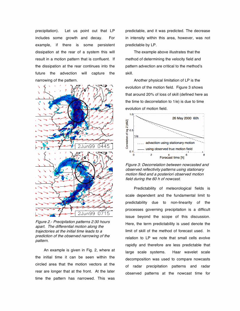
narrowing of the pattern.
Figure 2.- Precipitation patterns 2:30 hours apart. The differential motion along the trajectories at the initial time leads to a prediction of the observed narrowing of the pattern.
An example is given in Fig. 2, where at
the initial time it can be seen within the
circled area that the motion vectors at the
rear are longer that at the front. At the later
time the pattern has narrowed. This was
predictable, and it was predicted. The decrease
in intensity within this area, however, was not
predictable by LP.
The example above illustrates that the
method of determining the velocity field and
pattern advection are critical to the method’s
skill.
Another physical limitation of LP is the
evolution of the motion field. Figure 3 shows
that around 20% of loss of skill (defined here as
the time to decorrelation to 1/e) is due to time
evolution of motion field.
Figure 3: Decorrelation between nowcasted and observed reflectivity patterns using stationary motion filed and a posteriori observed motion field during the 60 h of nowcast.
Predictability of meteorological fields is
scale dependent and the fundamental limit to
predictability due to non-linearity of the
processes governing precipitation is a difficult
issue beyond the scope of this discussion.
Here, the term predictability is used denote the
limit of skill of the method of forecast used. In
relation to LP we note that small cells evolve
rapidly and therefore are less predictable that
large scale systems. Haar wavelet scale
decomposition was used to compare nowcasts
of radar precipitation patterns and radar
observed patterns at the nowcast time for
different scales. An analysis of four days of
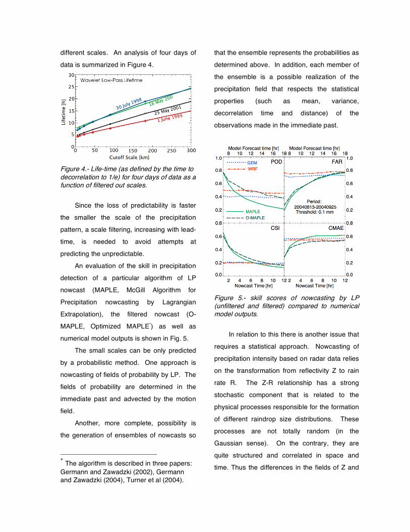
data is summarized in Figure 4.
Figure 4.- Life-time (as defined by the time to decorrelation to 1/e) for four days of data as a function of filtered out scales.
Since the loss of predictability is faster
the smaller the scale of the precipitation
pattern, a scale filtering, increasing with lead-
time, is needed to avoid attempts at
predicting the unpredictable.
An evaluation of the skill in precipitation
detection of a particular algorithm of LP
nowcast (MAPLE, McGill Algorithm for
Precipitation nowcasting by Lagrangian
Extrapolation), the filtered nowcast (O-
MAPLE, Optimized MAPLE*) as well as
numerical model outputs is shown in Fig. 5.
The small scales can be only predicted
by a probabilistic method. One approach is
nowcasting of fields of probability by LP. The
fields of probability are determined in the
immediate past and advected by the motion
field.
Another, more complete, possibility is
the generation of ensembles of nowcasts so
* The algorithm is described in three papers: Germann and Zawadzki (2002), Germann and Zawadzki (2004), Turner et al (2004).
that the ensemble represents the probabilities as
determined above. In addition, each member of
the ensemble is a possible realization of the
precipitation field that respects the statistical
properties (such as mean, variance,
decorrelation time and distance) of the
observations made in the immediate past.
Figure 5.- skill scores of nowcasting by LP (unfiltered and filtered) compared to numerical model outputs.
In relation to this there is another issue that
requires a statistical approach. Nowcasting of
precipitation intensity based on radar data relies
on the transformation from reflectivity Z to rain
rate R. The Z-R relationship has a strong
stochastic component that is related to the
physical processes responsible for the formation
of different raindrop size distributions. These
processes are not totally random (in the
Gaussian sense). On the contrary, they are
quite structured and correlated in space and
time. Thus the differences in the fields of Z and
R are also structured with spatial and
temporal scales of correlation.
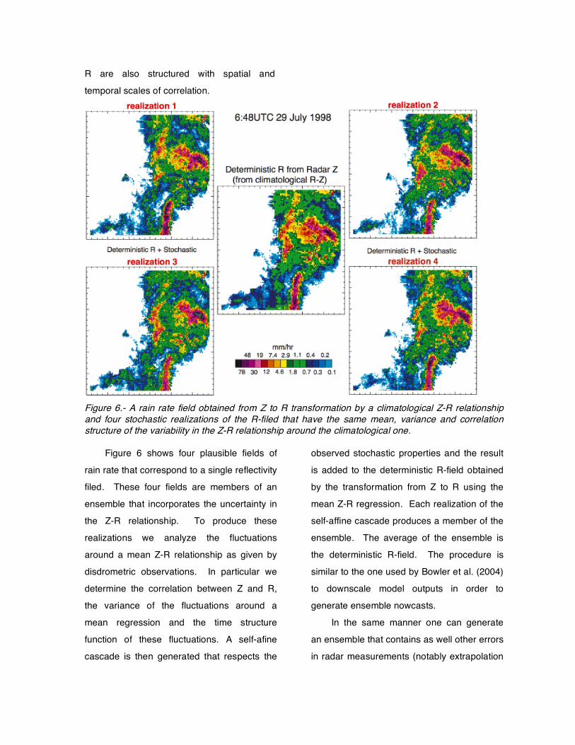
Figure 6.- A rain rate field obtained from Z to R transformation by a climatological Z-R relationship and four stochastic realizations of the R-filed that have the same mean, variance and correlation structure of the variability in the Z-R relationship around the climatological one.
Figure 6 shows four plausible fields of
rain rate that correspond to a single reflectivity
filed. These four fields are members of an
ensemble that incorporates the uncertainty in
the Z-R relationship. To produce these
realizations we analyze the fluctuations
around a mean Z-R relationship as given by
disdrometric observations. In particular we
determine the correlation between Z and R,
the variance of the fluctuations around a
mean regression and the time structure
function of these fluctuations. A self-afine
cascade is then generated that respects the
observed stochastic properties and the result
is added to the deterministic R-field obtained
by the transformation from Z to R using the
mean Z-R regression. Each realization of the
self-affine cascade produces a member of the
ensemble. The average of the ensemble is
the deterministic R-field. The procedure is
similar to the one used by Bowler et al. (2004)
to downscale model outputs in order to
generate ensemble nowcasts.
In the same manner one can generate
an ensemble that contains as well other errors
in radar measurements (notably extrapolation
to ground) and the uncertainty due to the non-
predictability of the small scales.
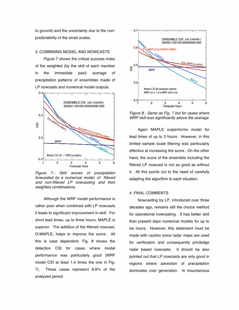
3. COMBINING MODEL AND NOWCASTS
Figure 7 shows the critical success index
of the weighted (by the skill of each member
in the immediate past) average of
precipitation patterns of ensembles made of
LP nowcasts and numerical model outputs.
Figure 7.- Skill scores of precipitation forecasted by a numerical model, of filtered and non-filtered LP nowcasting and their weighted combinations.
Although the WRF model performance is
rather poor when combined with LP nowcasts
it leads to significant improvement in skill. For
short lead times, up to three hours, MAPLE is
superior. The addition of the filtered nowcast,
O-MAPLE, helps to improve the score. All
this is case dependent. Fig. 8 shows the
detection CSI for cases where model
performance was particularly good (WRF
model CSI at least 1.4 times the one in Fig.
7). These cases represent 8.8% of the
analyzed period.
Figure 8.- Same as Fig. 7 but for cases where WRF skill was significantly above the average
Again MAPLE outperforms model for
lead times of up to 3 hours. However, in this
limited sample scale filtering was particularly
effective at increasing the score. On the other
hand, the score of the ensemble including the
filtered LP nowcast is not as good as without
it. All this points out to the need of carefully
adapting the algorithm to each situation.
4. FINAL COMMENTS
Nowcasting by LP, introduced over three
decades ago, remains still the choice method
for operational nowcasting. It has better skill
than present days numerical models for up to
six hours. However, this statement must be
made with caution since radar maps are used
for verification and consequently priviledge
radar based nowcasts. It should be also
pointed out that LP nowcasts are only good in
regions where advection of precipitation
dominates over generation. In mountainous
regions LP has little skill (this also holds for
NWP).
Further improvements in the skill of LP
nowcasts will be difficult to achieve. Attempts
at incorporating tendencies have been
unsuccessful. The motion field already
captures growth and decay that leads to
persistent changes in the pattern.
It is likely that incorporating uncertainties
as well as physical information from other
sources (including information from NWP) into
a stochastic generation of ensembles is the
road to follow.
Combination of LP nowcasts with NWP
leads to improvement in skill. It is likely that
progress in technology, particularly computing
capability, will lead to improvements in
resolution of numerical models and beter data
assimilation. We should expect some
improvement in NWP. This will be
automatically incorporated into the nowcasts
obtained by combination of LP nowcasting
and NWP.
Acknowledgments Many people contributed to obtain the
results shown in this extended abstract,
notably: Gyuwon Lee, Urs Germann, Alamelu
Kilambi, Alan Seed and Barry Turner. WRF
model outputs were provided by Weather
Decision Technologies, Inc. Financial support
for this work was provided by a grant from the
Canadian Foundation for Climate and
Atmospheric Sciences (CFAS)
REFERENCES Bowler, N., C. Pierce and A. Seed, 2004: STEPS:
A probabilistic precipitation forecasting scheme which merges extrapolation nowcast with downscaled NWP. Q. J. R. Meteolol. Soc., 999, 1-34.
Germann, U. and I. Zawadzki, 2002: Scale dependence of predictability of precipitation from continental radar images. Part I: Description of methodology. Weather and Forecasting, 130, 2859-2873.
Germann, U. and I. Zawadzki, 2004: Scale dependence of predictability of precipitation from continental radar images. Part 2: Probability Forcasts. J. of Appl. Meteorology, 43, 74-89.
Turner, B., I. Zawadzki and U. Germann, 2004: Scale dependence of predictability of precipitation from continental radar images. Part 3: Operational implementation. J. of Appl. Meteorology, 43, 231–248.