Embed Size (px)
Citation preview
Available online at www.scholarsresearchlibrary.com
Scholars Research Library
Archives of Applied Science Research, 2011, 3 (2):537-550
(http://scholarsresearchlibrary.com/archive.html)
ISSN 0975-508X
CODEN (USA) AASRC9
537 Scholars Research Library
Aspects of the geology and groundwater conditions of Asaba, Nigeria
Akpoborie1*, I. A., B. Nfor2, A.A.I Etobro 1 and S. Odagwe3
1Dept. of Geology, Delta State University, Abraka, Nigeria 2Dept. of Geology, Anambra State University, Uli, Nigeria
3Aquix Ltd., Asaba, Nigeria ______________________________________________________________________________ ABSTRACT Outcrop observations and borehole litho logs have been used to show that contrary to previous opinion, an approximately 25-30m thick alluvial terrace deposit underlies Asaba the administrative headquarter of Delta State, Nigeria. This superficial deposit masks the underlying Oligocene Ogwashi-Asaba Formation. A new map showing the approximate areal distribution of this superficial deposit is presented. The alluvial terrace deposit in combination with the upper horizon of the Ogwashi-Asaba Formation is the first and preferred aquifer exploited by hundreds of shallow water supply boreholes. The second aquifer horizon of the Ogwashi-Asaba Formation occurs at greater depths and contains iron rich water. It is also more difficult to drill into due to loss of circulation problems. It is shown that the west to east regional flow regime in the first aquifer has been distorted in the West End area of the city due to heavy groundwater abstraction such that flow direction is now east to west and the River Niger could be directly recharging the aquifer in this area with an implied risk of contamination. Management of the aquifer is recommended. Key words: superficial deposits, geologic fabric, general hydrogeology, urban groundwater. ______________________________________________________________________________
INTRODUCTION
Prior to 1992, Asaba was a small provincial town located on the west bank of the River Niger directly across river from Onitsha on the east bank. In July 1992, the town was designated the administrative capital of a newly created Delta State. The change in status resulted in an instantaneous influx of people, industry, and the associated rise in the demand for infrastructure, goods and services. In anticipation of this expansion, government acquired a capital territory, with the old Asaba town as nexus. Known as the Asaba Capital Territory it is about 230Km2 in area and includes the towns of Ibusa to the west and Okpanam to the north of the main Asaba
Akpoborie I. A.et al Arch. Appl. Sci. Res., 2011, 3 (2):537-550 _____________________________________________________________________________
538 Scholars Research Library
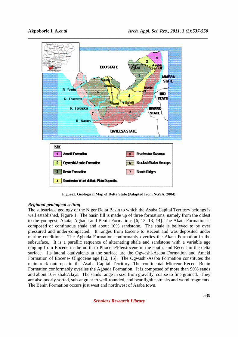
town. Safe housing continued infrastructural expansion and increased reliance on ground water resources require a clear understanding of the underlying geology. A review of the literature however reveals that there appears to be some disagreement about the underlying geology of Asaba. This should not be so because Asaba is located on the Ogwashi-Asaba Formation in the Geological Map of Nigeria [1], Figure 1, as well as by Reyment [2, p.67] and Simpson [3]. However, Offodile [4,5] in a regional classification of major hydrogeological basins in Nigeria alternately ascribes the Asaba area first to the Anambra Basin and secondly, to the Niger Delta Basin. Nwajide [6] clearly demarcates the Anambra Basin from the Niger Delta Basin on which Asaba is located. Offodile’s map [5, p.119] suggests that by logical extrapolation, Asaba which is approximately across the river from Onitsha would be underlain by the Nanka Sands member of the Ameki Formation. This could be interpreted to mean that the Ogwashi-Asaba Formation which overlies the Ameki Formation is absent from Asaba as reflected by Orajaka and Egboka [7, Figure 3, p.121] in their description of lateritic iron deposits in Anambra. Furthermore, Okagbare [8] asserts that Asaba is underlain directly by the Benin Formation while Osiatuma [9] somewhat inconsistently places the city at first on the Ogwashi-Asaba Formation then proceeds in the same study to state that ground water is obtained from the Benin Formation. A primary objective of this paper therefore is to establish through field evidence and other available information the underlying geology of Asaba in order to achieve the second objective which is to describe existing ground water conditions. A clear definition of the ground water conditions is important because Akpoborie et al. [10] have projected a rise in demand for water in the ACT from 38,500m3 per day in 2006 to about 77,000m3 per day by 2025 and if ground water remains the sole source of supply as it is today, additional boreholes will be required to meet this increased demand. Existing ground water conditions have crucial implications for the successful execution of such a massive groundwater exploitation programme as well as for sustainable environmental management in this rapidly growing urban environment. Description of the Area The city of Asaba, Figure 1, falls approximately between Latitude 6040I- 60 15IN and Longitude 6040IE - 6045IE, is bound on the east and north east by the River Niger and on the west by the rolling slopes of the Asaba plateau. In addition to being the administrative headquarters of Delta state, it is also the headquarters of Oshimili South Local Government Area. The River Niger and the Asaba Plateau with its undulating slopes dominate the Asaba landscape. These slopes descend gently eastwards towards the River Niger such that Asaba city itself is located on the valley and west bank of the river. Okpanam and Ibusa are located on the scarp of the Asaba plateau. The plateau itself disappears completely just south of Asaba. Several streams that originate as springs at higher elevation dissect the plateau slopes but only one, the relatively broad Amilimocha River joins the River Niger at Asaba town. Mean annual temperatures range from about 220C to 340C, while rainfall is between 1,501mm and 1850mm; mean evapotranspiration is 1117mm [11].
Akpoborie I. A.et al Arch. Appl. Sci. Res., 2011, 3 (2):537-550 _____________________________________________________________________________
539 Scholars Research Library
Figure1. Geological Map of Delta State (Adapted from NGSA, 2004).
Regional geological setting The subsurface geology of the Niger Delta Basin to which the Asaba Capital Territory belongs is well established, Figure 1. The basin fill is made up of three formations, namely from the oldest to the youngest, Akata, Agbada and Benin Formations [6, 12, 13, 14]. The Akata Formation is composed of continuous shale and about 10% sandstone. The shale is believed to be over pressured and under-compacted. It ranges from Eocene to Recent and was deposited under marine conditions. The Agbada Formation conformably overlies the Akata Formation in the subsurface. It is a parallic sequence of alternating shale and sandstone with a variable age ranging from Eocene in the north to Pliocene/Pleistocene in the south, and Recent in the delta surface. Its lateral equivalents at the surface are the Ogwashi-Asaba Formation and Ameki Formation of Eocene- Oligocene age [12, 15]. The Ogwashi-Asaba Formation constitutes the main rock outcrops in the Asaba Capital Territory. The continental Miocene-Recent Benin Formation conformably overlies the Agbada Formation. It is composed of more than 90% sands and about 10% shale/clays. The sands range in size from gravelly, coarse to fine grained. They are also poorly-sorted, sub-angular to well-rounded, and bear lignite streaks and wood fragments. The Benin Formation occurs just west and northwest of Asaba town.
Akpoborie I. A.et al Arch. Appl. Sci. Res., 2011, 3 (2):537-550 _____________________________________________________________________________
540 Scholars Research Library
FIELD METHODS A combination of field observations and borehole litho-sections were used to determine the relationship between the superficial deposits and the underlying bedrock. Rock exposures were observed and described in situ while drill cuttings were collected directly from the borehole drilling sites and described. Rest water levels of sixteen of the completed wells were measured with a dip meter on July 15, 2007, the wet season. An Ertec model GPS instrument was used to position the wells as well as determine the approximate elevation of each well head. A contouring computer package was employed in generating the head distribution and depth to water level maps.
RESULTS
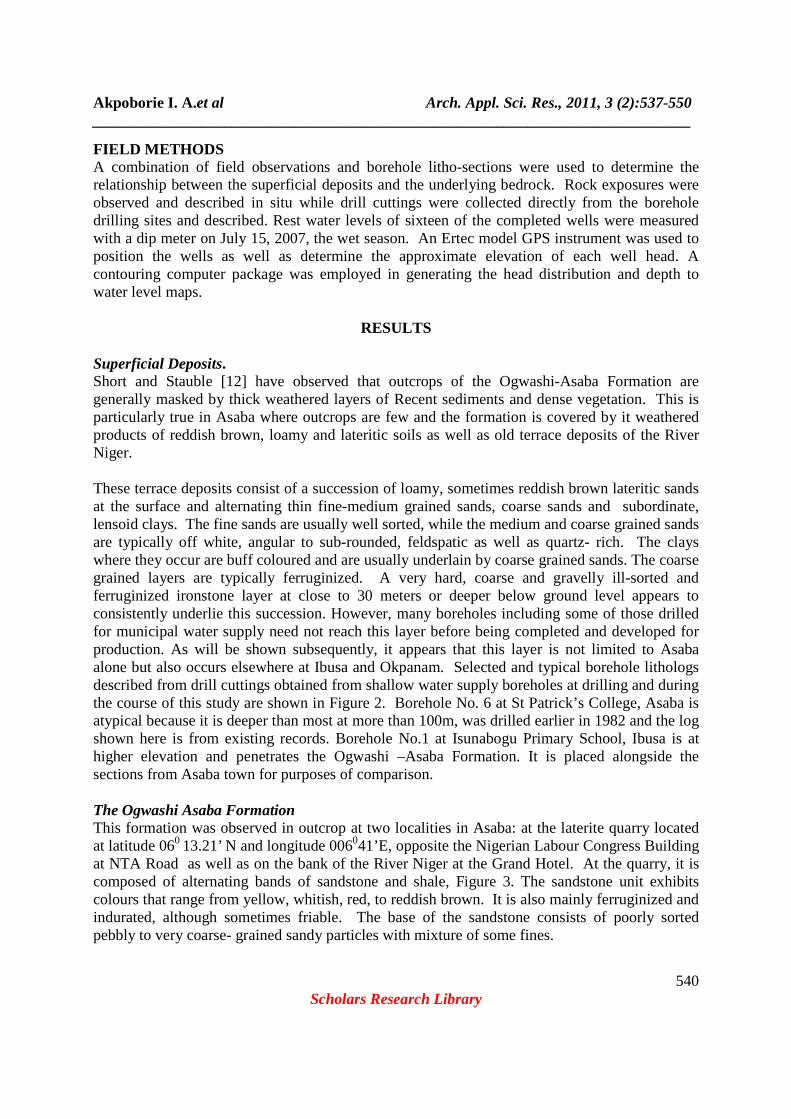
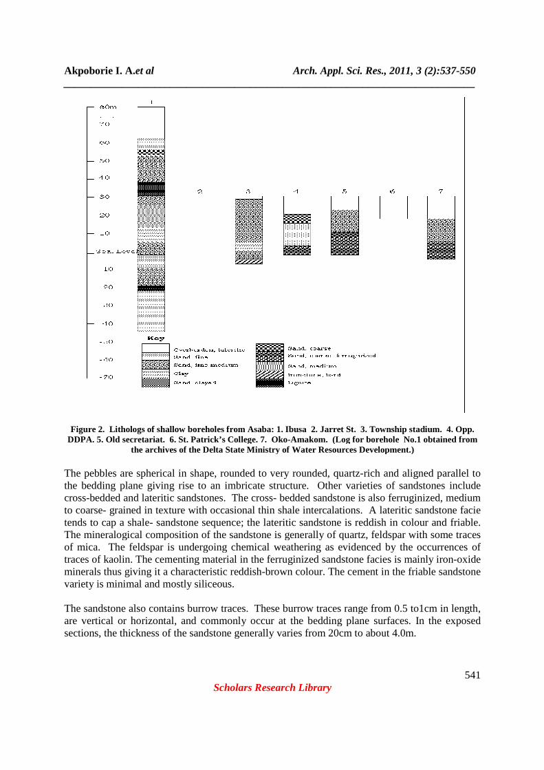
Superficial Deposits. Short and Stauble [12] have observed that outcrops of the Ogwashi-Asaba Formation are generally masked by thick weathered layers of Recent sediments and dense vegetation. This is particularly true in Asaba where outcrops are few and the formation is covered by it weathered products of reddish brown, loamy and lateritic soils as well as old terrace deposits of the River Niger. These terrace deposits consist of a succession of loamy, sometimes reddish brown lateritic sands at the surface and alternating thin fine-medium grained sands, coarse sands and subordinate, lensoid clays. The fine sands are usually well sorted, while the medium and coarse grained sands are typically off white, angular to sub-rounded, feldspatic as well as quartz- rich. The clays where they occur are buff coloured and are usually underlain by coarse grained sands. The coarse grained layers are typically ferruginized. A very hard, coarse and gravelly ill-sorted and ferruginized ironstone layer at close to 30 meters or deeper below ground level appears to consistently underlie this succession. However, many boreholes including some of those drilled for municipal water supply need not reach this layer before being completed and developed for production. As will be shown subsequently, it appears that this layer is not limited to Asaba alone but also occurs elsewhere at Ibusa and Okpanam. Selected and typical borehole lithologs described from drill cuttings obtained from shallow water supply boreholes at drilling and during the course of this study are shown in Figure 2. Borehole No. 6 at St Patrick’s College, Asaba is atypical because it is deeper than most at more than 100m, was drilled earlier in 1982 and the log shown here is from existing records. Borehole No.1 at Isunabogu Primary School, Ibusa is at higher elevation and penetrates the Ogwashi –Asaba Formation. It is placed alongside the sections from Asaba town for purposes of comparison. The Ogwashi Asaba Formation This formation was observed in outcrop at two localities in Asaba: at the laterite quarry located at latitude 060 13.21’ N and longitude 006041’E, opposite the Nigerian Labour Congress Building at NTA Road as well as on the bank of the River Niger at the Grand Hotel. At the quarry, it is composed of alternating bands of sandstone and shale, Figure 3. The sandstone unit exhibits colours that range from yellow, whitish, red, to reddish brown. It is also mainly ferruginized and indurated, although sometimes friable. The base of the sandstone consists of poorly sorted pebbly to very coarse- grained sandy particles with mixture of some fines.
Akpoborie I. A.et al _____________________________________________________________________________
Figure 2. Lithologs of shallow boreholes from Asaba: 1. Ibusa 2. Jarret St. 3. Township stadium. 4. Opp. DDPA. 5. Old secretariat. 6. St. Patrick’s College. 7. Oko
the archives of the Delta State Ministry of Water Resources Development.) The pebbles are spherical in shape, rounded to very rounded, quartzthe bedding plane giving rise to an imbricate structure. Other varieties of sandstones include cross-bedded and lateritic sandstones. The crossto coarse- grained in texture with occatends to cap a shale- sandstone sequence; the lateritic sandstone is reddish in colour and friable. The mineralogical composition of the sandstone is generally of quartz, feldspar with some trof mica. The feldspar is undergoing chemical weathering as evidenced by the occurrences of traces of kaolin. The cementing material in the ferruginized sandstone facies is mainly ironminerals thus giving it a characteristic reddishvariety is minimal and mostly siliceous. The sandstone also contains burrow traces. These burrow traces range from 0.5 to1cm in length, are vertical or horizontal, and commonly occur at the bedding plane surfaces. Isections, the thickness of the sandstone generally varies from 20cm to about 4.0m.
Arch. Appl. Sci. Res., 2011, 3 (2):_____________________________________________________________________________
Scholars Research Library
Figure 2. Lithologs of shallow boreholes from Asaba: 1. Ibusa 2. Jarret St. 3. Township stadium. 4. Opp.
DDPA. 5. Old secretariat. 6. St. Patrick’s College. 7. Oko-Amakom. (Log for borehole No.1 obtained from the archives of the Delta State Ministry of Water Resources Development.)
The pebbles are spherical in shape, rounded to very rounded, quartz-rich the bedding plane giving rise to an imbricate structure. Other varieties of sandstones include
bedded and lateritic sandstones. The cross- bedded sandstone is also ferruginized, medium grained in texture with occasional thin shale intercalations. A lateritic sandstone facie
sandstone sequence; the lateritic sandstone is reddish in colour and friable. The mineralogical composition of the sandstone is generally of quartz, feldspar with some trof mica. The feldspar is undergoing chemical weathering as evidenced by the occurrences of traces of kaolin. The cementing material in the ferruginized sandstone facies is mainly ironminerals thus giving it a characteristic reddish-brown colour. The cement in the friable sandstone variety is minimal and mostly siliceous.
The sandstone also contains burrow traces. These burrow traces range from 0.5 to1cm in length, are vertical or horizontal, and commonly occur at the bedding plane surfaces. Isections, the thickness of the sandstone generally varies from 20cm to about 4.0m.
Arch. Appl. Sci. Res., 2011, 3 (2):537-550 _____________________________________________________________________________
541
Figure 2. Lithologs of shallow boreholes from Asaba: 1. Ibusa 2. Jarret St. 3. Township stadium. 4. Opp. Amakom. (Log for borehole No.1 obtained from
the archives of the Delta State Ministry of Water Resources Development.)
rich and aligned parallel to the bedding plane giving rise to an imbricate structure. Other varieties of sandstones include
bedded sandstone is also ferruginized, medium sional thin shale intercalations. A lateritic sandstone facie
sandstone sequence; the lateritic sandstone is reddish in colour and friable. The mineralogical composition of the sandstone is generally of quartz, feldspar with some traces of mica. The feldspar is undergoing chemical weathering as evidenced by the occurrences of traces of kaolin. The cementing material in the ferruginized sandstone facies is mainly iron-oxide
r. The cement in the friable sandstone
The sandstone also contains burrow traces. These burrow traces range from 0.5 to1cm in length, are vertical or horizontal, and commonly occur at the bedding plane surfaces. In the exposed sections, the thickness of the sandstone generally varies from 20cm to about 4.0m.
Akpoborie I. A.et al Arch. Appl. Sci. Res., 2011, 3 (2):537-550 _____________________________________________________________________________
542 Scholars Research Library
The sandstone units are inter-bedded with relatively thin beds of shale. The shales are fissile and laminated. The colour grades from whitish to brown with depth, becoming darker with depth because of the presence of organic matter. The lignite seams that characterize the Ogwashi Asaba at depth, Figure 3, are normally associated with these shales and clay shales. At the Grand Hotel outcrop the formation is exposed on the bank of the River Niger about 300m south of the Grand Hotel recreation beach. The outcrop consists of dark reddish brown highly ferruginized and hard, indurated conglomerate which is as poorly sorted and peebly as the basal unit of the section observed further northwest at the NLC quarry. The exposure also displays a fining upwards sequence: a 10 cm thick basal siliceous conglomrate unit overlain by approximately 1.5 m thick very coarse-medium grained ferruginized sandstone. This is topped by weathered loamy material. The bed dip gently at approximately 50 westwards and due to its hard and resistant nature appears to be responsible for the straight north –south trending attitude of the bank in this section of the river. This straight section continues southwards for about eight kilometers to the Niger Bridge that is indeed sited on the narrowest section of the river in this vicinity.
Figure 3. Stratigraphic succession of the Ogwashi- Asaba Formation at the NTA Road Quarry, Asaba
An outcrop of this unit which occurs at Okute-Ugbor on the outskirts of Okpanam has also been described by Osiatuma [8]. At Okute-Ugbor, it is excavated for use as building stone. The same deposit occurs across the River Niger on the east bank where it is also quarried for building stone. This bed is impenetrable with the manual equipment used for drilling by artisanal drillers in Asaba and most domestic boreholes are limited by and terminated above it. It therefore defines where it occurs, the upper limit of the Ogwashi Asaba Formation in the alluvial valley occupied by central Asaba. Synthesis of superficial geology The regional geological map of Delta State, Figure 1, shows a narrow tongue of the deposits of the Sombreiro-Warri Deltaic Plain extending northwards from Ughelli to Asaba where it thins
Akpoborie I. A.et al Arch. Appl. Sci. Res., 2011, 3 (2):537-550 _____________________________________________________________________________
543 Scholars Research Library
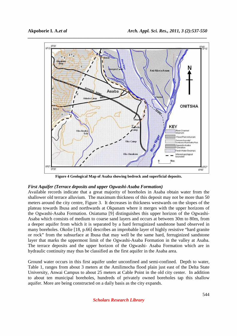
out. The lithological descriptions observed from drill cuttings described and presented in Figure 3 are similar to lithologies observed from other localities on the Sombreiro- Warri Deltaic Plain. The main difference is that outside the Asaba area, these deposits are underlain by the Benin Formation. At Asaba, they are underlain by the Ogwashi –Asaba Formation. In addition, the regional Nigerian Geological Survey Agency map, Figure 1, also suggests that the Freshwater Swamps flank the River Niger at Asaba and that the city is specifically located on these Freshwater Swamp deposits. In reality, field evidence suggests that this is not strictly correct. The Meander Belt/ Freshwater Swamps that occupy the low-lying River Niger floodplain and which may be assumed to be equivalents of the Recent Alluvium of the combined River Niger/Anambra River flood plain as suggested by Orajaka and Egboka [7, p. 121, Figure 3] are absent at and in the vicinity of Asaba. The combined River Niger/Anambra River flood plain terminates at the confluence of both rivers that occurs directly across the river from Asaba. The flood plain re-emerges south of Asaba and widens out as the River Niger flood plain that merges with what is described as the “Meander Belt, Back Swamps and Fresh Water Swamps” of the geological map of the Nigeria [1]. The alluvial deposits of these two flood plains, which are lithologically similar, are essentially the same as those deposits that make up the contemporary sand bars that characterize the main channel of the River Niger. These channel deposits occur below the 50- foot contour, and have been estimated to be up to 100 meters thick by NEDECO [16] and Tahal Engineers and Associates [17]. Above the 100- foot contour in the vicinity of Asaba, the older terrace deposits which are equivalents of the Sombreiro-Warri Deltaic Plain deposits occur. These factors were taken into consideration in drawing the inferred boundaries in the proposed geological map of Asaba shown in Figure 4 where the city is properly located on the Sombreiro-Warri Deltaic plain. The Freshwater Swamps on which it is incorrectly located in the existing Geological Survey Agency (2004) map start to occur only south of the present city limits. Groundwater Occurrence Surface and ground water resources are present in abundance in Asaba. Rainfall as mentioned previously is high at 1900mm annual average. Much of the rain is lost as run off which drains by gravity to the River Niger. Some of it also gathers in pools and poodles all over the city from where it is either evaporated or infiltrates into the ground as direct recharge. Ground water occurs in all the geological formations described in the foregoing: the older terrace deposits, the Ogwashi-Asaba Formation and the deeper Ameki Formation. The Ameki Formation is relatively too deep in this area to be considered an economically viable aquifer, as a result of which no boreholes are drilled into it. Thus two important and economically viable aquifers exist in Asaba. The first aquifer consists of the terrace deposits and the underlying upper horizons of the Ogwashi-Asaba Formation. The second and deeper aquifer consists of the sand horizons of the Ogwashi Asaba Formation.
Akpoborie I. A.et al Arch. Appl. Sci. Res., 2011, 3 (2):537-550 _____________________________________________________________________________
544 Scholars Research Library
Figure 4 Geological Map of Asaba showing bedrock and superficial deposits.
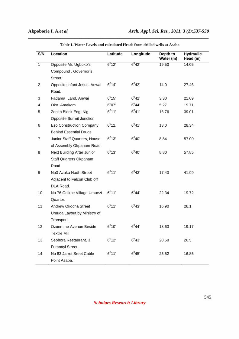
First Aquifer (Terrace deposits and upper Ogwashi-Asaba Formation) Available records indicate that a great majority of boreholes in Asaba obtain water from the shallower old terrace alluvium. The maximum thickness of this deposit may not be more than 50 meters around the city centre, Figure 3. It decreases in thickness westwards on the slopes of the plateau towards Ibusa and northwards at Okpanam where it merges with the upper horizons of the Ogwashi-Asaba Formation. Osiatuma [9] distinguishes this upper horizon of the Ogwashi-Asaba which consists of medium to coarse sand layers and occurs at between 30m to 80m, from a deeper aquifer from which it is separated by a hard ferruginized sandstone band observed in many boreholes. Okolie [18, p.66] describes an improbable layer of highly resistive “hard granite or rock” from the subsurface at Ibusa that may well be the same hard, ferruginized sandstone layer that marks the uppermost limit of the Ogwashi-Asaba Formation in the valley at Asaba. The terrace deposits and the upper horizon of the Ogwashi- Asaba Formation which are in hydraulic continuity may thus be classified as the first aquifer in the Asaba area. Ground water occurs in this first aquifer under unconfined and semi-confined. Depth to water, Table 1, ranges from about 3 meters at the Amilimocha flood plain just east of the Delta State University, Anwai Campus to about 25 meters at Cable Point in the old city center. In addition to about ten municipal boreholes, hundreds of privately owned boreholes tap this shallow aquifer. More are being constructed on a daily basis as the city expands.
Akpoborie I. A.et al Arch. Appl. Sci. Res., 2011, 3 (2):537-550 _____________________________________________________________________________
545 Scholars Research Library
Table 1. Water Levels and calculated Heads from drilled wells at Asaba
S/N Location Latitude Longitude Depth to Water (m)
Hydraulic Head (m)
1 Opposite Mr. Ugboko’s
Compound , Governor’s
Street.
6012’ 6042’ 19.50 14.05
2 Opposite infant Jesus, Anwai
Road.
6014’ 6042’ 14.0 27.46
3 Fadama Land, Anwai 6015’ 6042’ 3.30 21.09
4 Oko Amakom 6007’ 6044’ 5.27 19.71
5 Zenith Block Eng. Nig,
Opposite Surmit Junction
6011’ 6041’ 16.76 39.01
6 Eso Construction Company
Behind Essential Drugs
6012, 6041’ 18.0 28.34
7 Junior Staff Quarters, House
of Assembly Okpanam Road
6013’ 6040’ 8.84 57.00
8 Next Building After Junior
Staff Quarters Okpanam
Road
6013’ 6040’ 8.80 57.85
9 No3 Azuka Nadh Street
Adjacent to Falcon Club off
DLA Road.
6011’ 6043’ 17.43 41.99
10 No 76 Odikpe Village Umuezi
Quarter.
6011’ 6044’ 22.34 19.72
11 Andrew Okocha Street
Umuda Layout by Ministry of
Transport.
6011’ 6043’ 16.90 26.1
12 Ozuemme Avenue Beside
Textile Mill
6010’ 6044’ 18.63 19.17
13 Sephora Restaurant, 3
Fumnayi Street.
6012’ 6043’ 20.58 26.5
14 No 83 Jarret Sreet Cable
Point Asaba.
6011’ 6045’ 25.52 16.85
Akpoborie I. A.et al Arch. Appl. Sci. Res., 2011, 3 (2):537-550 _____________________________________________________________________________
546 Scholars Research Library
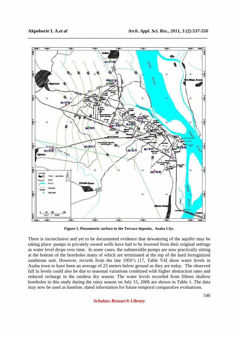
Figure 5. Piezometric surface in the Terrace deposits, Asaba City.
There is inconclusive and yet to be documented evidence that dewatering of the aquifer may be taking place: pumps in privately owned wells have had to be lowered from their original settings as water level drops over time. In some cases, the submersible pumps are now practically sitting at the bottom of the boreholes many of which are terminated at the top of the hard ferruginized sandstone unit. However, records from the late 1950’s [17, Table V4] show water levels in Asaba town to have been an average of 23 meters below ground as they are today. The observed fall in levels could also be due to seasonal variations combined with higher abstraction rates and reduced recharge in the rainless dry season. The water levels recorded from fifteen shallow boreholes in this study during the rainy season on July 15, 2006 are shown in Table 1. The data may now be used as baseline, dated information for future temporal comparative evaluations.
Akpoborie I. A.et al Arch. Appl. Sci. Res., 2011, 3 (2):537-550 _____________________________________________________________________________
547 Scholars Research Library
The recorded levels and deduced head distribution of the water table plotted on the city map are shown in Figure 5. The aquifer is also unable to sustain wells that are fitted with high yield pumps. One example is the municipal borehole located at St. Patrick’s College that ran dry within hours of pumping when it was fitted with a high yield 30 horse power pump. Sustained pumping was resumed when a lower capacity pump was installed. The same phenomenon was observed further south of the city at the public water supply agency’s headworks at Ogbogonogo. Regional ground water flow in the combined alluvial deposit/ Ogwashi Asaba Formation first aquifer is generally down gradient from west to east towards the Niger River. However, and as it is clear from Figure 5, a major distortion in flow is already occurring. This distortion appears to be centered on the location of Asaba Alluminium in the West End area, and stretches westwards to the General Hospital and Asaba Stadium. Northwards, it also includes the locality of the Delta Television Station and the offices of the Federal Ministry of Works. Heavy abstractions in these areas appear to have reversed the gradient such that flow is now from east, the Amilimocha River and the River Niger towards this area. Sustained pumping at existing levels or increased pumping will have the effect of further depressing the water levels in this area; increase the flux from the River Niger while the affected area will grow larger. Aquifer tests are rare. Analysis of early time pumping well data of the borehole at St Patrick’s College, which were obtained from a private drilling contractor [19] were analyzed in course of the study. The Cooper and Jacob [20] straight line approximation yielded a transmissivity value of 365 m2 per day. The borehole was screened in the two medium grained sand horizons that are separated by the 3m thick ferruginized sandstone unit, Figure 3, that apparently separates the alluvial terrace deposits from the Ogwashi- Asaba Formation proper at this point. Recharge estimates have not been attempted in this study but sources of recharge would include direct rainfall and the floodwaters of the River Niger. In addition, Osiatuma [9] has estimated that as much as 2.0 x 10⁶ litres of sewage is introduced into the groundwater system daily from on-site domestic septic tanks that are used in the absence of a central sewage system. Indeed, Foster et al. [21] identify other sources of recharge to such a shallow aquifer in the urban environment to include distribution mains leakages, losses on consumer premises, firefighting, mains flushing and illicit connections to public water supply mains which all together could represent an approximate 30-60 percent of overall water supplied by public agency water distribution systems. They also argue that more than 90 per cent of all water supplied in such urban environments after deduction of 10 per cent for consumptive use ends up as recharge to ground water in such environments that lack central sewerage as is the case in Asaba. The meaning of this is that most of the water abstracted from the shallow alluvial terrace aquifer is returned as recharge which might explain why water levels appear to have held steady over time in most parts of the city. The quality of ground water with respect to physico-chemical characteristics is generally good, and is used without treatment [10].
Akpoborie I. A.et al Arch. Appl. Sci. Res., 2011, 3 (2):537-550 _____________________________________________________________________________
548 Scholars Research Library
The Second Aquifer (The Ogwashi-Asaba Formation ) The main saturated zone of the Ogwashi-Asaba Formation is found at greater depths in Asaba. Outside of Asaba where the formation is exploited for water supply, it consists of medium- coarse grained sands and sandstones which are sandwiched between the grey-dark clays, clay shale and lignite bands that characterize the formation. Osiatuma [9] has described the regional ground water flow system in the Ogwashi-Asaba and established that static water level in this aquifer ranges between 110m and about 180m. Ground water flow direction is from north to south [17, 9] as opposed to the west to east flow direction for the first aquifer. Loss of circulation of drilling fluids into the formation also characterizes drilling operations in this horizon both east and west of the River Niger [9, 22]. The quality of water in the formation is good, and is used for domestic purposes without treatment. However, elevated levels of iron appear to be widespread, especially when boreholes penetrate the ferruginized sandstone layer. It seems that water occurs in the formation under reducing conditions and turns reddish brown in colour when pumped to the surface due to the deposition of ferric oxides. Concentrations of up to 4mg/l have thus been reported from Ibusa and Okpanam [23, 10]. Indeed in the valley at Asaba, municipal water supply boreholes which are drilled beyond the alluvial terrace deposits and through the ferruginized sandstone layer into the Ogwashi-Asaba formation proper also yield water with high iron content. While it has been suggested [24] that high iron content in this area could be attributed to improper borehole completion practices and use of substandard materials, Ezenwa [25] has shown that high iron content is a characteristic feature of the Ogwashi-Asaba Formation. Finally, high nitrate levels of up to 30mg/l in water from shallow domestic water supply boreholes in Okpanam have been recorded but these have been adduced to fertilizer practice by farmers in this rural community [10].
DISCUSSION AND CONCLUSION
It has been established that Asaba is located on the Ogwashi-Asaba formation and a map of the aerial distribution of the geological units which include the important superficial deposits is presented. The Ogwashi-Asaba Formation is generally masked by its weathered products as well as by older terrace alluvium in the valley occupied by the city of Asaba. The terrace alluvium is an elongate strip that borders the River Niger’s west bank in this vicinity and is a continuation of the deposits of the Sombreiro-Warri Deltaic Plain that are more prominent in the south and central part of Delta State. It is in hydraulic continuity with the River Niger and its channel deposits, as well as with the upper horizon of the underlying Ogwashi-Asaba Formation. Combined with this upper horizon of the Ogwashi-Asaba Formation, it is classified as the first aquifer underlying Asaba that is exploited extensively for water supply purposes. Southwards, and because the Asaba plateau has also disappeared, it merges with and is indistinguishable from the widened River Niger flood plain deposits. The aquifer configuration has some implications for the sustainable management of the aquifer. Continued laissez faire exploitation of the aquifer especially in the presence of increased demands has lead to induced recharge from the Amilimocha River and the River Niger whose waters are showing elevated levels of heavy metals and other pollutants [26]. One way to avoid this would be to restrict or at least control further exploitation of the aquifer in the West End
Akpoborie I. A.et al Arch. Appl. Sci. Res., 2011, 3 (2):537-550 _____________________________________________________________________________
549 Scholars Research Library
area, centered on Illah Road and defined on the west by the Asaba City Stadium. Furthermore, heavy abstraction for municipal supplies could be confined to specially designated well fields to be located southwards at Okwe. Although water would have to be pumped up gradient from these fields to supply the city the advantages of a dedicated and protected well field for management of the aquifer would by far outweigh this disadvantage. A programme of ground water level monitoring and water quality surveillance should also be formally initiated. The borehole and water level data presented herein could be used as an initial network to monitor spatial and temporal water level and water quality changes.
REFERENCES
[1] Nigerian Geological Survey Agency, The Geological Map of Nigeria. NGSA, Abuja, 2004. [2] R.A. Reyment, Aspects of the geology of Nigeria, Ibadan University Press, Ibadan, Nigeria, 1965, 133pp. [3] A. Simpson, Notes on the hydrology of parts of Asaba Division. Geological Survey of Nigeria, Kaduna, Report No.857, 1947, 4pp. [4] M.E. Offodile, 1988, (1)1:63-74. [5] M.E. Offodile, An Approach to Ground Water Study and Development in Nigeria. Mecon Services, Jos, 1992, 247p. [6] C.S. Nwajide, A guide for geological field trips to Anambra and related sedimentary basins in southeastern Nigeria. PTDF Fund, Univ. of Nigeria, Nsukka, 2006, 68pp. [7] L.P.Orajaka and B.C.E. Egboka,. In: C.O. Ofoegbu (ed.), The Benue Trough Structure and Evolution, Vieweg and Sohn, Braunschweig/Weisbaden, 1990:115-124 [8] E. Okagbare, The Delta Bureaucrat, Asaba, 2004, 4(1): 80-83. [9] J.U.Osiatuma, M.Sc. Thesis, University of Benin, Benin City, 2005. [10] I.A. Akpoborie, A.U. Oteri and S. Idundun, 2005. Groundwater resources of the Asaba Capital Territory. Project Report, Delta State Ministry of Water Resources Development, Asaba, 2005, 35pp. [11] Nigerian Meteorological Agency, Asaba Meteorological Bulletin. In: National Meteorological Report, 2003. [12] K.C. Short, and A.J. Stauble, Bull. Amer. Assoc. Petr. Geol., 1967, 54(5):761-779. [13] E.J.Frank, and E.A. Cordry,. Proc. 7th World Petrol. Congress, 1967, 2:195-209. [14] Murat, R.C., In: TFJ Dessauvagie and AJ Whiteman (eds), African Geology Ibadan Univ. Press, Ibadan, 1970, 251-268. [15] L.O.Asseez, 1989, In: CA Kogbe (ed) Geology of Nigeria. Rockview, Jos, 1989, 311-334. [16] NEDECO, River Studies and Recommendations on Improvement of Niger the Benue. Amsterdam, NEDECO, 1959. [17] Tahal (Water Planning) Ltd., Master Plan for Urban and Rural Water Supply (Mid-Western Nigeria). Delta State Min. of Water Resources, Asaba, 1965. [18] E.C. Okolie, Archives of Physics Research, 2010, 1 (3):62-71 [19] Richdrill Nigeria Ltd., St. Patrick’s College Borehole Completion Report. Prepared for the Federal Ministry of Water Resources, Abuja, 1983. [20] H.H. Cooper, Jr. and C.E. Jacob, Transactions American Geophysical Union, 1946, 27, 526-534. [21] S. Foster, A. Lawrence and B. Morris, Groundwater in urban development. World Bank Technical Paper No.390, 1988, 55pp.
Akpoborie I. A.et al Arch. Appl. Sci. Res., 2011, 3 (2):537-550 _____________________________________________________________________________
550 Scholars Research Library
[22] B. N. Nfor, J. Appl. Sci. Environ Mgt., 2006, 10(3):31-35. [23] Delta State Urban Water Board, 1992. Improvement of Ibusa Water Supply Scheme: Report on Test borehole drilled at Ibusa. File Report, Delta State Urban Water Board, Asaba, 1992, 11pp. [24] S.M.O. Ohagi and C.N. Akujieze, Water Resources, 1989, 1(2):192-196. [25] S.O. Ezenwa, Water Resources, 1996 ,7(1&2):31-41. [26] E.O. Adaikpoh, G. E. Nwajei, and I. A. Akpoborie, Advances in Natural and Applied Sciences Research , 2004, 2 (1):9-16.