Embed Size (px)
Citation preview


ENVIRONMENT MANAGEMENT PLAN
NUAHAT
VillageJajpur
ENVIRONMENT CONSULTANT
KALYANI LABORATORIES PVT.LTD.(Sl. No. 92 , List of NABET Accredited Consultant Organizations
(Alphabetically)/ Rev.
PLOT NO.-1867, BOMIKHAL, BHUBANESWAR
Document No. : KLPL-EIA/(MM/B2)2017 -272
Rev. No.: 00 Date: 31.05.2017
LESSEE
ENVIRONMENT MANAGEMENT PLAN
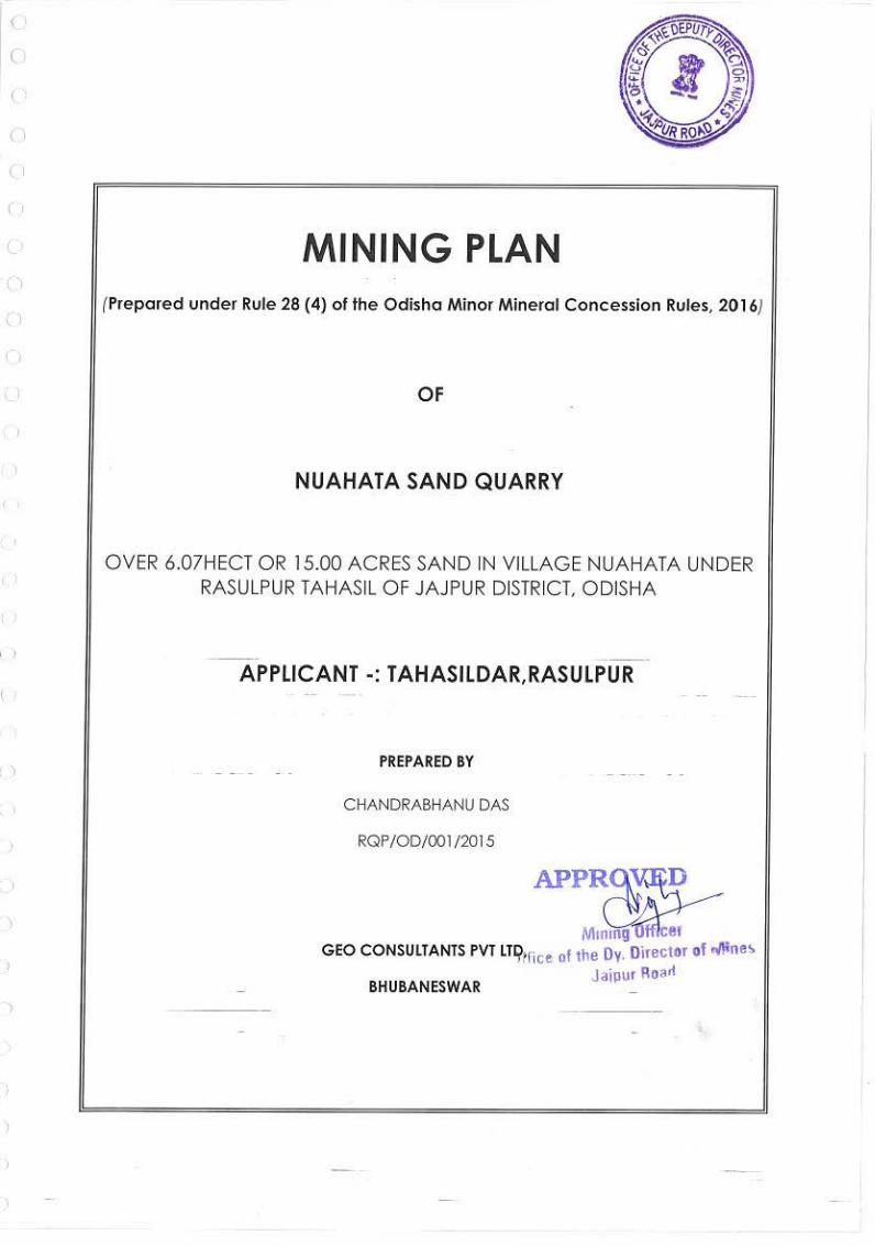
NUAHAT SAND QUARRY
Village-Nuahat, RasulpurJajpur District, Odisha
ENVIRONMENT CONSULTANT:
KALYANI LABORATORIES PVT.LTD. , List of NABET Accredited Consultant Organizations
(Alphabetically)/ Rev. 53, May 05, 2017)
1867, BOMIKHAL, BHUBANESWAR
272 Document Name: Environment Management Plan
Quarry, Rasulpur, Jajpur, Odisha
Rev. No.: -- Date: --
LESSEE- TAHASILDAR, RASULPUR
Doc. No. KLPL-EIA/(MM/B2)2017
ENVIRONMENT MANAGEMENT PLAN
SAND QUARRY
RasulpurTahasil of
:
, List of NABET Accredited Consultant Organizations
1867, BOMIKHAL, BHUBANESWAR -10
Environment Management Plan for Nuahat Sand
TAHASILDAR, RASULPUR
EIA/(MM/B2)2017 - 272
Environment Management Plan for Nuahat Sand Quarry, Rasulpur Tahasil, Jajpur District, Odisha
Prepared By: Kalyani Laboratories Pvt. Ltd., Bhubaneswar (Doc. No. KLPL-EIA/(MM/B2)2017 – 272) Page 2
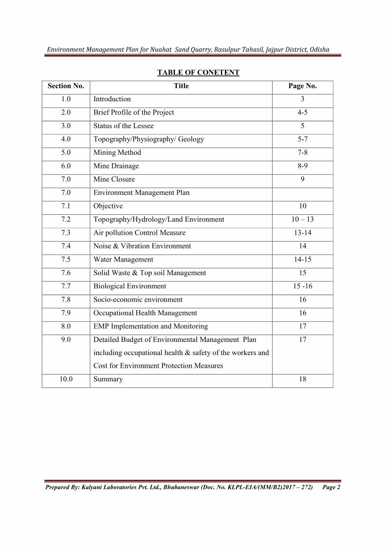
TABLE OF CONETENT
Section No. Title Page No.
1.0 Introduction 3
2.0 Brief Profile of the Project 4-5
3.0 Status of the Lessee 5
4.0 Topography/Physiography/ Geology 5-7
5.0 Mining Method 7-8
6.0 Mine Drainage 8-9
7.0 Mine Closure 9
7.0 Environment Management Plan
7.1 Objective 10
7.2 Topography/Hydrology/Land Environment 10 – 13
7.3 Air pollution Control Measure 13-14
7.4 Noise & Vibration Environment 14
7.5 Water Management 14-15
7.6 Solid Waste & Top soil Management 15
7.7 Biological Environment 15 -16
7.8 Socio-economic environment 16
7.9 Occupational Health Management 16
8.0 EMP Implementation and Monitoring 17
9.0 Detailed Budget of Environmental Management Plan
including occupational health & safety of the workers and
Cost for Environment Protection Measures
17
10.0 Summary 18

Environment Management Plan for Nuahat Sand Quarry, Rasulpur Tahasil, Jajpur District, Odisha
Prepared By: Kalyani Laboratories Pvt. Ltd., Bhubaneswar (Doc. No. KLPL-EIA/(MM/B2)2017 – 272) Page 3
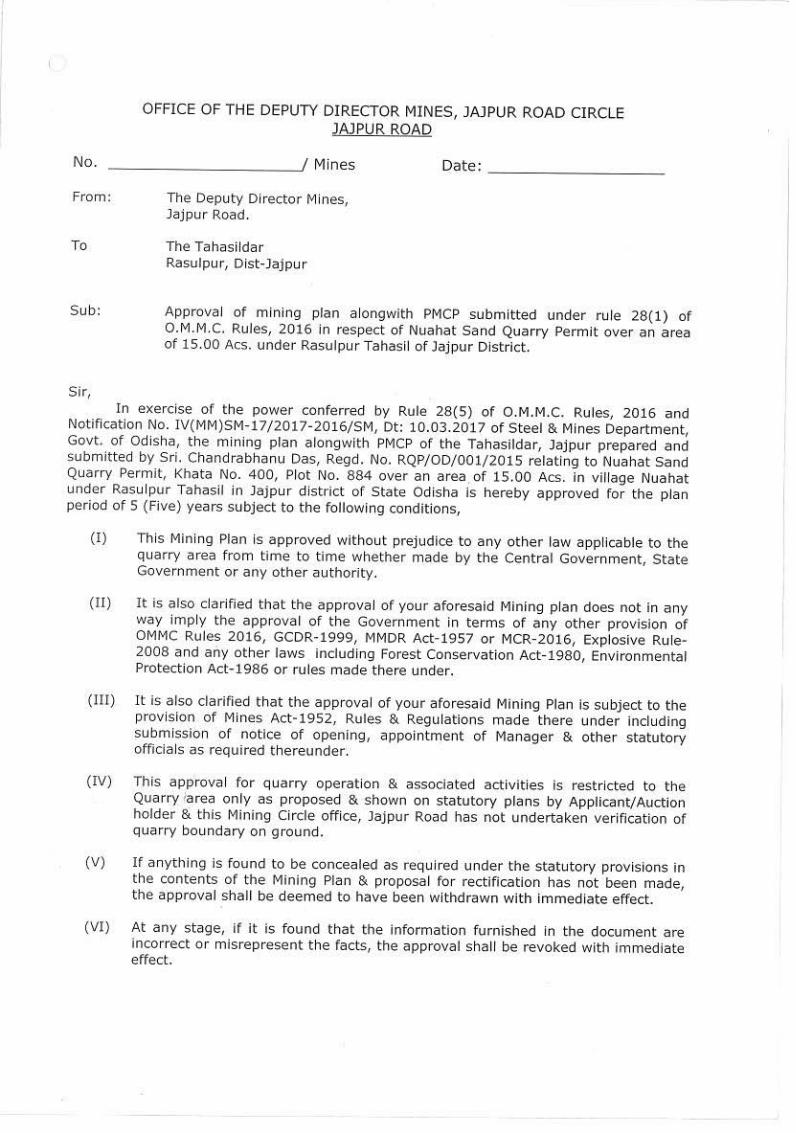
1.0 INTRODUCTION:
The Environmental Management plan has been prepared for Nuahat Sand Quarry over an
area of 6.07 Ha or 15.00 acres for excavation of river sand from Brahmani river bed under
Rasulpur Tahasil of Jajpur district, Odisha. Nuahat River Sand Bed lease area over 6.07 hectares
is located in village Nuahat of Rasulpur Tahasil, Jajpur ,Odisha is granted for mining lease of
sand bed in favour of Tahasildar Rasulpur.
As per EIA Notification 2006 and subsequent amendment Environment clearance is
mandatory for mining of minerals. As per MoEF circular 15.01.2016 the minor mineral project
below 25 Ha has been considered as B2 category and will be appraised based on Form 1, Pre
feasibility report and Environment Management Plan.
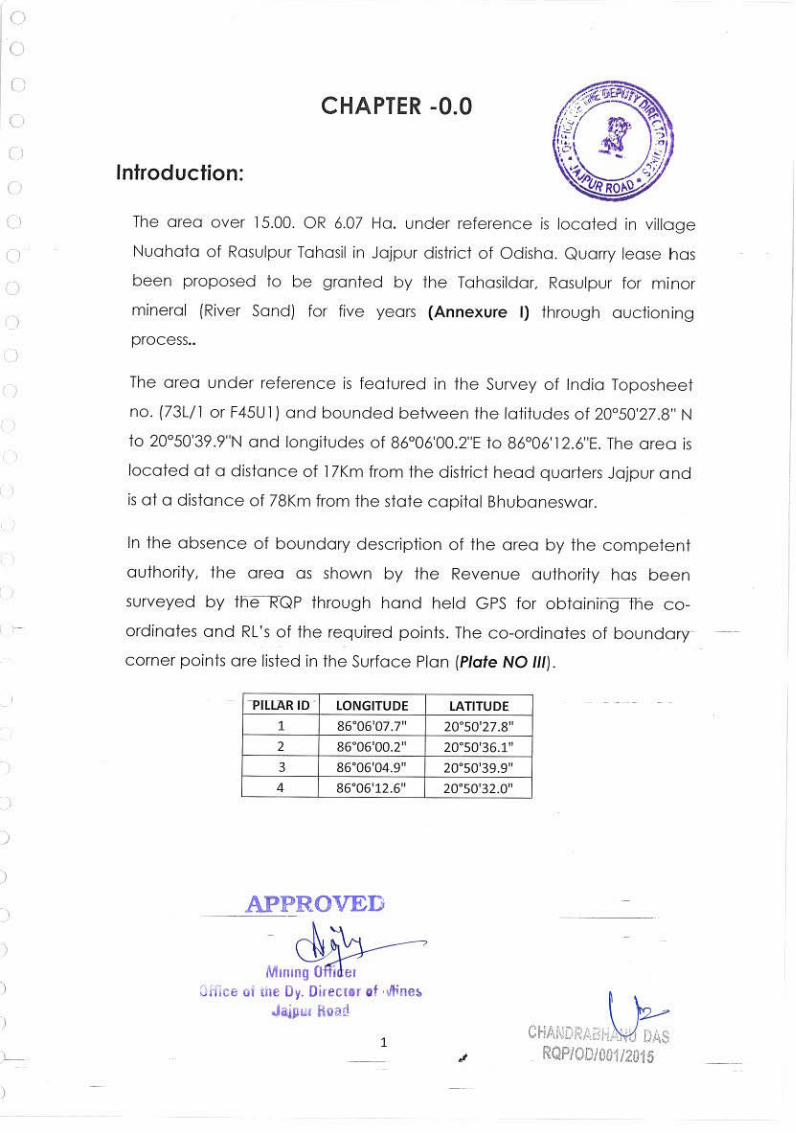
The area under reference is featured in the Survey of India Toposheet no. (73L/1 or
F45U1) and bounded between the latitudes of 20°50'27.8" N to 20°50'39.9"N and longitudes of
86°06'00.2"E to 86°06'12.6"E. The area is located at a distance of 17Km from the district head
quarters Jajpur and is at a distance of 78Km from the state capital Bhubaneswar.
Mining within or near river bed has a direct impact on the land topography, drainage and
flow pattern of the river. This may cause hazardous impact on biological environment of the
river ecosystem. This may also cause adverse impact on in-stream biota and riparian habitats.
This disturbance may also cause changes in channel configuration and flow-paths. The impact of
mining on other environment includes increase dust emission during loading, unloading and
transportation activity. The ground water regime and surface water quality may have some
impact due to the mining process. To mitigate the impact of river sand mining the Environment
management Plan has been prepared for Nuahat River Sand Bed over an area of 15.000 acres or
6.07 hect on Brahmani River.
Environment Management Plan for Nuahat Sand Quarry, Rasulpur Tahasil, Jajpur District, Odisha
Prepared By: Kalyani Laboratories Pvt. Ltd., Bhubaneswar (Doc. No. KLPL-EIA/(MM/B2)2017 – 272) Page 4
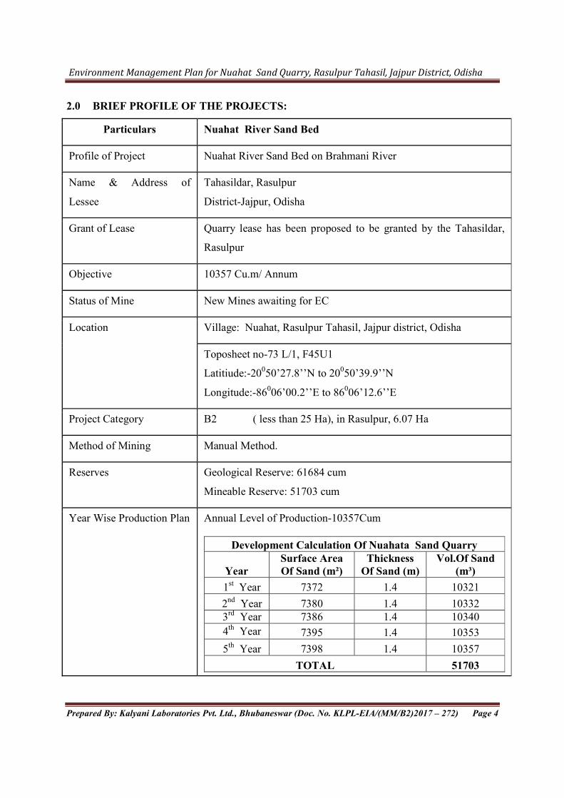
2.0 BRIEF PROFILE OF THE PROJECTS:
Particulars Nuahat River Sand Bed
Profile of Project Nuahat River Sand Bed on Brahmani River
Name & Address of
Lessee
Tahasildar, Rasulpur
District-Jajpur, Odisha
Grant of Lease Quarry lease has been proposed to be granted by the Tahasildar,
Rasulpur
Objective 10357 Cu.m/ Annum
Status of Mine New Mines awaiting for EC
Location Village: Nuahat, Rasulpur Tahasil, Jajpur district, Odisha
Toposheet no-73 L/1, F45U1
Latitiude:-20050’27.8’’N to 20050’39.9’’N
Longitude:-86006’00.2’’E to 86006’12.6’’E
Project Category B2 ( less than 25 Ha), in Rasulpur, 6.07 Ha
Method of Mining Manual Method.
Reserves Geological Reserve: 61684 cum
Mineable Reserve: 51703 cum
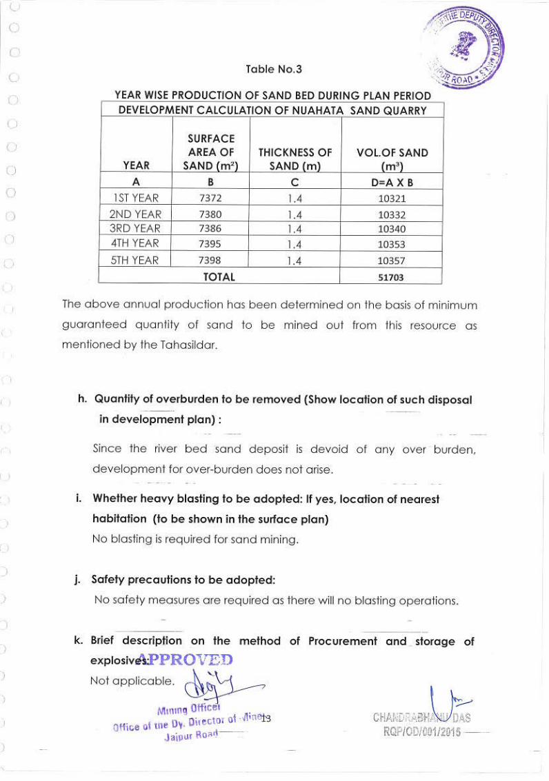
Year Wise Production Plan
Annual Level of Production-10357Cum
Development Calculation Of Nuahata Sand Quarry
Year Surface Area Of Sand (m²)
Thickness Of Sand (m)
Vol.Of Sand (m³)
1st Year 7372 1.4 10321
2nd Year 7380 1.4 10332 3rd Year 7386 1.4 10340
4th Year 7395 1.4 10353
5th Year 7398 1.4 10357
TOTAL 51703
Environment Management Plan for Nuahat Sand Quarry, Rasulpur Tahasil, Jajpur District, Odisha
Prepared By: Kalyani Laboratories Pvt. Ltd., Bhubaneswar (Doc. No. KLPL-EIA/(MM/B2)2017 – 272) Page 5
Waste Generation No Waste generated
Water/ Power Source of water is Tube well
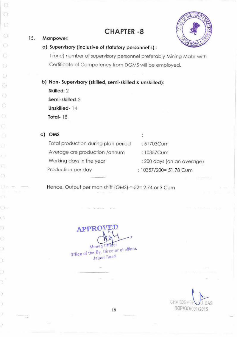
Manpower 18 no.
Use of Mineral Mined out sand will be utilized for domestic use only. Yearly
dispatched quantity will be 10357 cum.
3.0 STATUS OF THE LESSEE
The mining lease area at present belongs to Tahasildar, Rasulpur.
4.0 TOPOGRAPHY/PHYSIOGRAPHY/GEOLOGY:
a. Physiography:
The Sand bed is located on the River Brahmani. The Nuahat sand bed deposit represents
a gently sloping to almost flat terrain with highest altitude of 18 mRL. The general slope is
towards southeast. Vegetation is scanty with small bushes existing in the auction hold area.
There is no human settlement within the area.
b. Regional Geology:
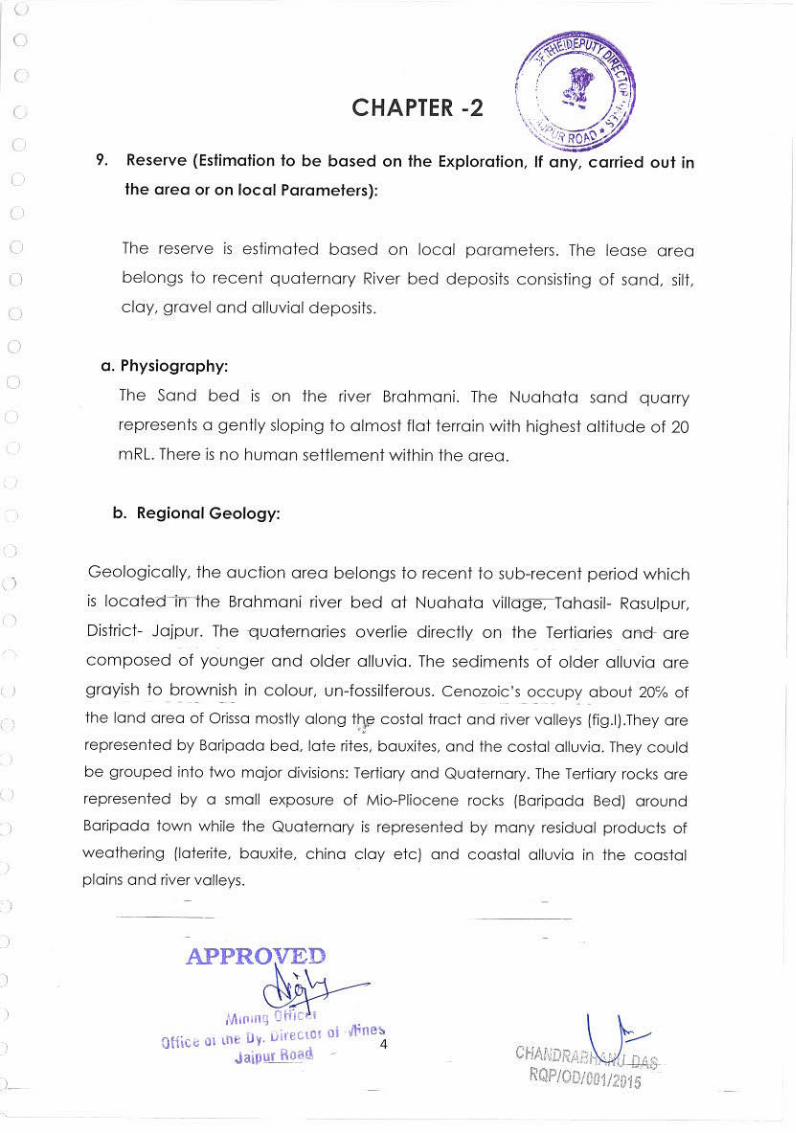
Geologically, the auction area belongs to recent to sub-recent period which is located in
the Brahmani river bed at Nuahat village, Tahasil- Rasulpur, District- Jajpur. The quaternaries
overlie directly on the Tertiaries and are composed of younger and older alluvia. The sediments
of older alluvia are grayish to brownish in colour, un-fossilferous. Cenozoic’s occupy about 20℅
of the land area of Orissa mostly along the costal tract and river valleys. They are represented by
Baripada bed, late rites, bauxites, and the costal alluvia. They could be grouped into two major
divisions: Tertiary and Quaternary. The Tertiary rocks are represented by a small exposure of
Mio-Pliocene rocks (Baripada Bed) around Baripada town while the Quaternary is represented
by many residual products of weathering (laterite, bauxite, china clay etc) and coastal alluvia in
the coastal plains and river valleys. The Stratigraphic succession of the area on regional basis can
be given as follow:
Type of Lithology Geological Horizon Age Sand, silt and clay Debi – kuakhai
stage(fluvial) Upper Holocene to recent age

Environment Management Plan for Nuahat Sand Quarry, Rasulpur Tahasil, Jajpur District, Odisha
Prepared By: Kalyani Laboratories Pvt. Ltd., Bhubaneswar (Doc. No. KLPL-EIA/(MM/B2)2017 – 272) Page 6
c. Local Geology
The sand deposit in Brahmani River near Nuahat belongs to recent to sub recent deposits of
Holocene age. Beach Sand, younger and older alluvium also belongs to the same age. The
proposed area is occupied by a gently sloping to almost flat deposits of sand. The basement
consists of Tertiary deposits and the sequence of litho-units encountered in the auction hold area
is as follows:
Sand
Alluvium
d. Lithology:
The characteristic features of the litho units of the area are described below:
Sand: The area under reference is covered with grey to white sand deposits with average
thickness of 1.4m. Sand by definition is a loose, incoherent mass of mineral materials and is a
Coastal sand deposits with a variety of recent marine shells e.g., Mactra sp, etc. with corresponding light colored yellow ,yellowish brown sediments without any organic remains of fluvial nature
Puri formation (Marine stage) prachi – Alaka fluvial stage
Youngest marine horizon. Age of shells by CI4 dating about 5000 to 8000 years B.P. Represents fluvial sediments of early Holocene age to upper Ho Holocene age
Light coloured limestone bearing sediments with fragmented and weathered organic remains (Echinoids, corals) occurring around 20-30 meters depth in Bhagabanpur bore hole with equivalent fluvial deposits.
Bhagabanpur formation (marine) and Burdha-Sukhabhadra fluvial stage
CI4 dating of shell fragments show ages of 20,000 to 30,000 year BP. Late Upper Pleistocene
~~~~~~~~~~~~~~~~~~~~~~~ Unconformity ~~~~~~~~~~~~~~~~~~~~~~~ Dark grey, very coarse to fine grained sediments containing significant quantity of organic shells, e.g., Oliva sp (Gastropada), Glycimeris sp (Pelecypod) and typical iron silicates oolites
Tolapada Bed (Marine) equivalent of Baripada Beds
Pre Deltaic sediments could be of Pliocene age
~~~~~~~~~~~~~~~~~~~~~~~ Unconformity ~~~~~~~~~~~~~~~~~~~~~~~
Basement rocks, e.g. khondalite, charnockite, gneisses etc. of Eastern Ghats group and sandstones and Carbonaceous shales of upper Gondwana Group.
Environment Management Plan for Nuahat Sand Quarry, Rasulpur Tahasil, Jajpur District, Odisha
Prepared By: Kalyani Laboratories Pvt. Ltd., Bhubaneswar (Doc. No. KLPL-EIA/(MM/B2)2017 – 272) Page 7
product of natural processes. These processes are the disintegration of rocks under the influence
of weathering and abrasion. When sand is freshly formed, the particles are usually angular and
sharply pointed, but they grow gradually smaller and more rounded as they become constantly
worn down by the wind or water. Sand particles tend to settle quite rapidly because of their
shape, density and size. Therefore, the concentration of sand is highest near the bed of a river and
lowest near the surface. Clean sand is indeed a rare commodity on land, but common in sand
dunes and beaches. The composition of sand is highly variable in nature, depending on the local
rock types/sources and conditions, but the most common constituent of sand in inland continental
settings and non-tropical coastal settings is silica (silicon dioxide or SiO2), usually in the form of
quartz which because of its chemical inertness and considerable hardness, is the most common
mineral resistant to weathering.
Alluvium: Decomposed vegetal materials admixed with clay and soil constitutes alluvium which
is underlain by the sand bed with some clayey matter.
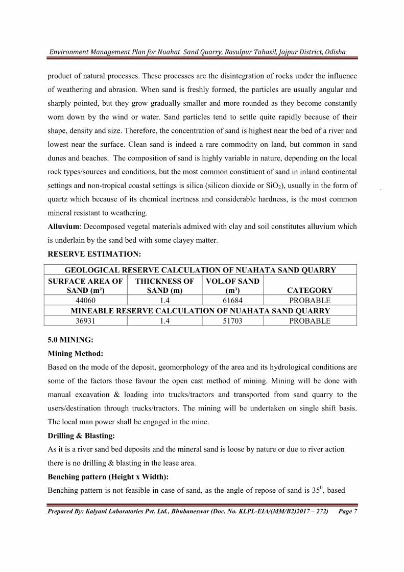
RESERVE ESTIMATION:
GEOLOGICAL RESERVE CALCULATION OF NUAHATA SAND QUARRY
SURFACE AREA OF SAND (m²)
THICKNESS OF SAND (m)
VOL.OF SAND (m³) CATEGORY
44060 1.4 61684 PROBABLE
MINEABLE RESERVE CALCULATION OF NUAHATA SAND QUARRY
36931 1.4 51703 PROBABLE 5.0 MINING:
Mining Method:
Based on the mode of the deposit, geomorphology of the area and its hydrological conditions are
some of the factors those favour the open cast method of mining. Mining will be done with
manual excavation & loading into trucks/tractors and transported from sand quarry to the
users/destination through trucks/tractors. The mining will be undertaken on single shift basis.
The local man power shall be engaged in the mine.
Drilling & Blasting:
As it is a river sand bed deposits and the mineral sand is loose by nature or due to river action
there is no drilling & blasting in the lease area.
Benching pattern (Height x Width):
Benching pattern is not feasible in case of sand, as the angle of repose of sand is 350, based
Environment Management Plan for Nuahat Sand Quarry, Rasulpur Tahasil, Jajpur District, Odisha
Prepared By: Kalyani Laboratories Pvt. Ltd., Bhubaneswar (Doc. No. KLPL-EIA/(MM/B2)2017 – 272) Page 8
on this the Ultimate pit slope Limit has been taken as 350. The maximum depth of mining
will be limited up to 1.4 m.
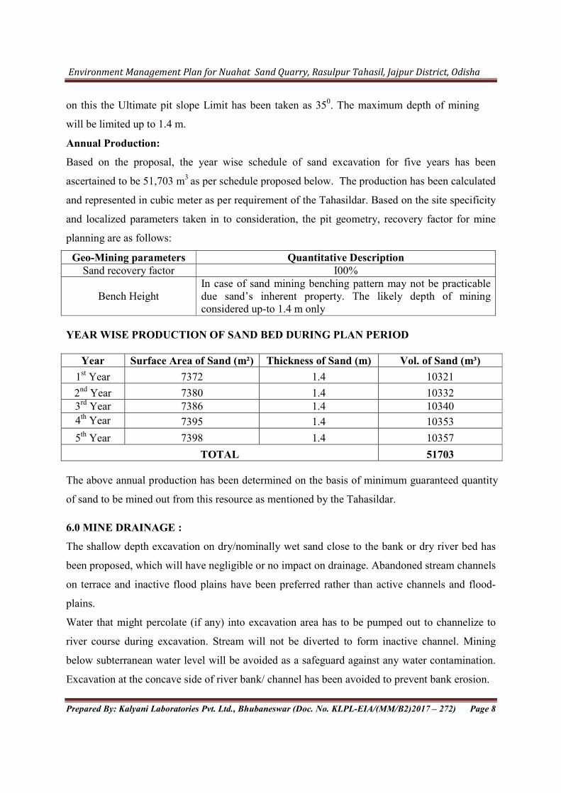
Annual Production:
Based on the proposal, the year wise schedule of sand excavation for five years has been
ascertained to be 51,703 m3 as per schedule proposed below. The production has been calculated
and represented in cubic meter as per requirement of the Tahasildar. Based on the site specificity
and localized parameters taken in to consideration, the pit geometry, recovery factor for mine
planning are as follows:
Geo-Mining parameters Quantitative Description Sand recovery factor I00%
Bench Height In case of sand mining benching pattern may not be practicable due sand’s inherent property. The likely depth of mining considered up-to 1.4 m only
YEAR WISE PRODUCTION OF SAND BED DURING PLAN PERIOD
Year Surface Area of Sand (m²) Thickness of Sand (m) Vol. of Sand (m³)
1st Year 7372 1.4 10321
2nd Year 7380 1.4 10332 3rd Year 7386 1.4 10340
4th Year 7395 1.4 10353
5th Year 7398 1.4 10357
TOTAL 51703
The above annual production has been determined on the basis of minimum guaranteed quantity
of sand to be mined out from this resource as mentioned by the Tahasildar.
6.0 MINE DRAINAGE :
The shallow depth excavation on dry/nominally wet sand close to the bank or dry river bed has
been proposed, which will have negligible or no impact on drainage. Abandoned stream channels
on terrace and inactive flood plains have been preferred rather than active channels and flood-
plains.
Water that might percolate (if any) into excavation area has to be pumped out to channelize to
river course during excavation. Stream will not be diverted to form inactive channel. Mining
below subterranean water level will be avoided as a safeguard against any water contamination.
Excavation at the concave side of river bank/ channel has been avoided to prevent bank erosion.

Environment Management Plan for Nuahat Sand Quarry, Rasulpur Tahasil, Jajpur District, Odisha
Prepared By: Kalyani Laboratories Pvt. Ltd., Bhubaneswar (Doc. No. KLPL-EIA/(MM/B2)2017 – 272) Page 9
It is observed from the dug well in the adjacent plain area and in the nearby villages that the
ground water table varies between 4m to 14 m from the surface level depending upon seasonal
variations. During dry season the water table falls to I4m from the surface where as during rainy
season the water table remains at 4m from the surface. As the mining activities presently
proposed are maximum up to 1.4 m that to within the river course and the total mining operation
will be achieved through manual means, so there will be no effect on ground water table.
7.0 MINE CLOSURE:
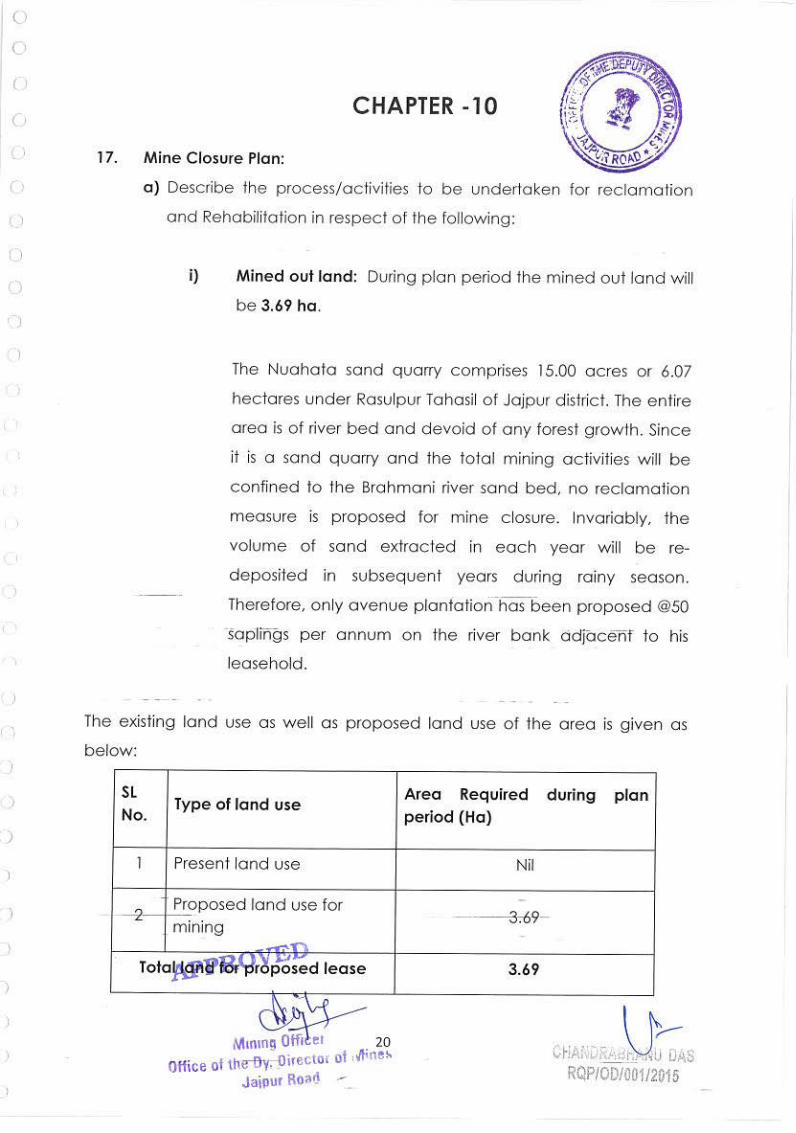
Mined out land: During plan period the mined out land will be 3.69 ha. The Nuahata sand
quarry comprises 15.00 acres or 6.07 hectares under Rasulpur Tahasil of Jajpur district. The
entire area is of river bed and devoid of any forest growth. Since it is a sand quarry and the total
mining activities will be confined to the Brahmani river sand bed, no reclamation measure is
proposed for mine closure. Invariably, the volume of sand extracted in each year will be re-
deposited in subsequent years during rainy season. Therefore, only avenue plantation has been
proposed @50 saplings per annum on the river bank adjacent to his leasehold.
Topsoil stack and its utilization:
There will be no generation of top soil in this Quarry since the mining for sand will be carried
out within the river bed and if there is generation of top soil it may be used for plantation on the
river bank as avenue plantation.
Environment Management Plan for Nuahat Sand Quarry, Rasulpur Tahasil, Jajpur District, Odisha
Prepared By: Kalyani Laboratories Pvt. Ltd., Bhubaneswar (Doc. No. KLPL-EIA/(MM/B2)2017 – 272) Page 10
8.0 ENVIRON MENT MANAGEMENT PLAN:
The Environmental management plan has been formulated for Nuahat Sand bed over an
area of 6.07 Ha of Tahasildar, Rasulpur to mitigated the adverse impact of the river sand bed on
Brahmani river on the surrounding environment. This includes an environmental policy on
protection of environment and public safety. The river management functions involve strategic
planning, sustainable allocation of resources and environment compatible mining methods for
protecting the health of the river system. Management of rivers includes legal, social and
economic considerations, as well as scientific insights. The map showing the environmental
features within 10 Km of the project site has been given as below:
The environment parameters affected due to sand mining project are land use, topography,
drainage pattern, water resource, soil quality, ambient air quality, socioeconomic status, ecology
and occupational health. The purpose of EMP is:
Preparation of effective, site specific and user friendly activity chart for EMP
The Environment Management Plan is a part of project implementation
This ensures the environment management documents prepared during project
implementation period.
8.1 OBJECTIVE:
The EMP has been worked out with the following objectives:
Restoration of landscape consistent with the economy of mining operations, keeping in
view the drainage pattern, geological stability, vegetation etc.
Minimization, mitigation and where possible elimination of degradation in land, quality
of air and water.
Making least disturbance to the water regime and water quality.
Least disruption to the existing basic ecological status in the mining area during mining.
8.2 TOPOGRAPHY, HYDROLOGY & LAND/ SOIL MANAGEMENT
The major impact of the river bed sand mines on the land environment is due creation of
access roads, mining operations, transportation of mined material. The study area itself being part of
Brahmani River course carries surface as well as ground water (under current). The flow of
surface/ground water (sub surface flow) is following the trend of topography. The area is part of dry
river bed for more than nine months in a year except for the rainy season.
Environment Management Plan for Nuahat Sand Quarry, Rasulpur Tahasil, Jajpur District, Odisha
Prepared By: Kalyani Laboratories Pvt. Ltd., Bhubaneswar (Doc. No. KLPL-EIA/(MM/B2)2017 – 272) Page 11
The ground water table will be about 4metres below the surface of river bed in the mining area
during the dry seasons will not be disturbed as ultimate working depth is 1.4 m below the ground
level. At the end of mining operations every yearly season, the flood waters would replenish the
mined material.
As per the mining plan there will be no waste generated due to sand mining. The impact
assessment and proposed mitigation measure is as below:
Assessment of
Impact
Mitigation Measures
Obstruction of
river Flow
The mining will be carried out in the dry areas of the river body in the non
monsoon seasons only. There will be no waste dumping in the lease area as
the total mined out material will be sellable. The excavated sand will
immediately transport out of the lease area. So that no dumping of the sand
will be there in the river bed. So there is no change in river flow pattern due
to the proposed mining activity.
Change in River
slope/
Morphology/
geometry and
elevation.
The mining operation will be carried out in the lease area leaving the water
cover area and the safety zone. The mining will be done only 1.4 m below
the surface level so that there will be no generation of deep pits in the lease
area. There will be no mining activity in the river bank and safety zone.
Change in land use
pattern of the lease
area
The land use pattern of the lease area belongs to Nadi Kisam and will
remain a part of the active river course of Brahmani River. The mining
activity will be carried out in the active stream only during the dry season.
So there will be no change in land use pattern of the lease area.
Impact on the
River Bridge
A fair weather bridge on Brahmani river is located at a distance of about
1.5 Km from the lease area, Riverbrduge on Singhpur Road is located at a
distance 4 Km from the lease area. A railway bridge on Brahamni river is
located at a distance of 6 Km from the lease area. As the road and rail
bridge located at a distance of more than 1 Km from the lease area the
impact on the mining on the river bridge is almost negligiable. However all
the safety measures for river bank conservation and other hydrological
management plan will be undertaken during the mining activities.
Environment Management Plan for Nuahat Sand Quarry, Rasulpur Tahasil, Jajpur District, Odisha
Prepared By: Kalyani Laboratories Pvt. Ltd., Bhubaneswar (Doc. No. KLPL-EIA/(MM/B2)2017 – 272) Page 12
In order to prevent the environmental degradation of leased mine area and its surroundings,
the following measures shall be taken;
• There will be no creation of pits on the river bed. All the quarries developed during the
excavation of the sand will be replenished in the monsoon season.
• Proper safety zone has been demarcated along the river bank and from the bridge.
• No mining activity will be carried out in the safety zone.
• No trees will be cut due to the proposed mining activity.
• The mining activity will be carried out during daylight only.
• The mining activities will be restricted to the dry seasons only and the mine will
remain completely closed during monsoon period.
• There will be no stockpiling of excavated sand on the river bed or river bank. The
excavated material will transport to the user agency as soon as possible.
• Water sprinkling on the transportation route as the river bed connecting to the highway
is un-metalled road.
• There will be minimum numbers of access roads to river bed, as cutting river banks
should be avoided and ramps are to be maintained.
Plantation and Soil Conservation
There is no soil over the sand bed; however the receding floods in the monsoon
season deposit some clay /soil carried down by river water. It is hardly a few millimetres thick and
of not much consequence. Even in the areas of no mining activity the process of deposition in one
season and transportation of previously deposited material in the next season takes place
along with deposition of fresh material by receding floods.
As the mining is on the river bed and will be covered by river water during monsoon
plantation programme will not be undertaken within the lease area. However, plantation activity
shall be undertaken in consultation with village panchayat near the river banks, avenue
plantation or Panchayat waste lands to improve the land quality, aesthetics and reduce soil
erosion.
Post mining land use
As the mining lease area is a part of active river course and water logging during every
monsoon season, the land degradation impact due to the excavation of sand during dry period of
the year will get replenished by fresh material and there shall not be any change in land use pattern
Environment Management Plan for Nuahat Sand Quarry, Rasulpur Tahasil, Jajpur District, Odisha
Prepared By: Kalyani Laboratories Pvt. Ltd., Bhubaneswar (Doc. No. KLPL-EIA/(MM/B2)2017 – 272) Page 13
of the mining lease area. In view of the above, the mining lease area would remain within the active
river course during and post mining operation.
8.3 AIR POLLUTION CONTROL MEASURES
The excavation of the sand from Nuahat River Sand Bed quarry is a manual process. The
only source of air pollution is due to the loading and transportation activity by trucks and
tractors. The proposed mining operations are not anticipated to raise the concentration of the
pollutants beyond prescribed limits. However, the following measures would be adopted to
mitigate the incremental load of particulate matter in ambient air.
Water sprinkling will be done for dust suppression on the unpaved road.
Leveling of roads connecting the sand source will be done to maintain the uniform speed
of the trucks/tippers.
The vehicles will be maintained properly and at regular intervals to control the air
emissions.
The transporting trucks will be covered by tarpaulin so that dust emission will be reduced.
Overloading will be avoided during the transportation.
Dust mask provided to the workers engaged at dust generation points like excavations,
loading and unloading points.
The route for sand transportation of the area has been made outside the human habitation.
8.3.1 Control of Gaseous Pollution
The project area is for excavation of sand from the river bed. The only source of gaseous
pollution is movement of vehicle. The mining process includes only manual mining without any
emission of gaseous pollutants. This project includes movement of only 4 tractors will be used for
transportation of sand from the lease area. So the gaseous pollution due to the present mining is
very less.
8.3.2 Control of Dust Pollution
The dust emission will be there during excavation of sand, loading and transportation of
sand. The measures taken of dust pollution control are as below:
The mines road will be properly maintained i.e. compacted, levelled for movement of
trucks and tractors.
The sand carrying trucks will be properly covered to reduce dust emission during the
movement of trucks.
Environment Management Plan for Nuahat Sand Quarry, Rasulpur Tahasil, Jajpur District, Odisha
Prepared By: Kalyani Laboratories Pvt. Ltd., Bhubaneswar (Doc. No. KLPL-EIA/(MM/B2)2017 – 272) Page 14
Overloading of the trucks will be avoided.
All the haulage road including the main ramp from the river will be kept wide, levelled,
compacted and properly maintained and maintained regularly to prevent dust emission.
8.4. NOISE AND VIBRATION ENVIRONMENT
The sand excavation process does not involve any heavy earth moving machinery, so there
will not be any major impact on noise level. There will be no drilling and blasting used for sand
lifting, hence no possibility of land vibration. It was found that the proposed mining activity will
not have any significant impact on the noise environment of the region. The only impact will be
due to transportation of sand by trucks and tractor trolleys. Though the source of noise is very
less following mitigation measures will be undertaken to maintain the noise level well within
the limit:
Minimum use of horns and speed limit of 10 kms in the village area.
Timely maintenance of vehicles and their silencers to minimize vibration and sound.
Provision of green belts in consultation with village panchayat near the river bank.
Care will be taken to produce minimum sound during sand loading and movement of
transporting vehicles.
Earmuffs will be provided to the workers working in the noisy areas.
8.5. WATER MANAGEMENT
Surface Water Management
As the proposed excavation of sand mining is only manual and no waste water will be
generated due to mining activity. During the sand excavation there is the possibility of increase
in turbidity in surface water pollution due to the excavation of sand. Utmost care will be taken
to minimize spillage of sand. The shallow depth excavation on dry/nominally wet sand close to
the bank or dry river bed has been proposed, which will have negligible or no impact on
drainage. Abandoned stream channels on terrace and inactive flood plains have been preferred
rather than active channels and flood-plains. Mining below subterranean water level will be
avoided as a safeguard against any water contamination. Excavation at the concave side of river
bank/ channel has been avoided to prevent bank erosion. Following environmental management
plan will be undertaken to minimize the surface water pollution:
The washing of trucks and tractor trolleys in the river will be completely avoided.
Environment Management Plan for Nuahat Sand Quarry, Rasulpur Tahasil, Jajpur District, Odisha
Prepared By: Kalyani Laboratories Pvt. Ltd., Bhubaneswar (Doc. No. KLPL-EIA/(MM/B2)2017 – 272) Page 15
Plantation along the river banks will undertaken on degraded Panchayat waste land to
improve its quality and utility.
Monitoring of the surface water quality in both upstream and downstream of both the lease
area will be carried out on quarterly basis to assess the impact of mining on River Bed.
(Brahmani river).
Ground water Management
It is observed from the dug well in the adjacent plain area and in the nearby villages that
the ground water table varies between 4m to 14 m from the surface level depending upon
seasonal variations. During dry season the water table falls to 14m from the surface where as
during rainy season the water table remains at 4m from the surface. As the mining activities
presently proposed are maximum up to 1.4 m that to within the river course and the total mining
operation will be achieved through manual means, so there will be no effect on ground water
table.
8.6. SOLID WASTE & TOP SOIL MANAGEMENT
As this is a river sand mine, there will be no generation of solid waste or top soil because
of the mining operation.
8.7 BIOLOGICAL ENVIRONMENT
The impact of sand excavation from the lease area on the biological environment will be
limited to the vegetation of the river bank, aquatic flora and aquatic fauna. The sand excavation
from the river bed may results instability of the river bank and loss of vegetation. The proposed
mitigation measures for minimizing the impact:
Development of green belt along the road side, river bank and village waste land.
Improvement of soil quality of the area and coverage by vegetation.
Stability of the river bank by grass and vegetation cover.
Conservation of biological diversity of the area.
8.7.1 Development of Green belt:
As the lease area is a part of active river course, development of green belt within the
lease area is not possible. There is the proposal for development of green belt along the road
side, river bank and village waste land. Plantation programme for the mines has been given in
as below:

Environment Management Plan for Nuahat Sand Quarry, Rasulpur Tahasil, Jajpur District, Odisha
Prepared By: Kalyani Laboratories Pvt. Ltd., Bhubaneswar (Doc. No. KLPL-EIA/(MM/B2)2017 – 272) Page 16
Programme of Plantation:
It is proposed for planting @50 saplings of suitable species per annum by the lessee in vicinity
of the river bank as avenue plantation which is to be undertaken in consultation with the
concerned authority.
8.7.2 Year Wise Progressive Green belt plan:
Year Number of saplings proposed Type of saplings 2015-16 50
Teak, Acasia Neem, Jamun
Mahaneem Mango
2016-17 50
2017-18 50
2018-19 50
2019-20 50
Total 250
8.8. SOCIO-ECONOMIC ENVIRONMENT
This project operation will provide livelihood to the poorest section of the society. The
overall impact of riverbed mining of sand on the socio economics of the area shall be positive
one, as not only it will generate employment opportunities for local population at mine site but
also in associated activity i.e. for transportation of mined material, construction activities etc . It
will also give a good boost to the general economy of the area by providing employment
opportunity to the local people. The project will help in enhancement of social infrastructure of
the area.
8.9 OCCUPATIONAL HEALTH MANAGEMENT
The mines worker will be provided with dust mask to minimize the inhalation of the
dust.
The mining site will be supplied with first aid facilities and the entire mines worker
will have access to that.
The workers will be well trained about the safety practices in the mining activities.
Free check up and medicine for treatment for their acute and chronic illness shall be
provided by the lessee.
Pre placement and periodical health check up camps will be conducted for the mines
workers.
Environment Management Plan for Nuahat Sand Quarry, Rasulpur Tahasil, Jajpur District, Odisha
Prepared By: Kalyani Laboratories Pvt. Ltd., Bhubaneswar (Doc. No. KLPL-EIA/(MM/B2)2017 – 272) Page 17
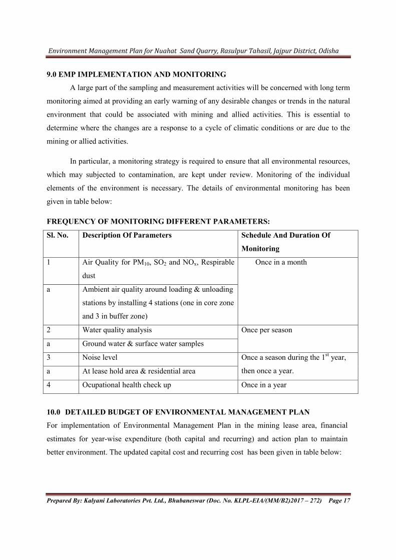
9.0 EMP IMPLEMENTATION AND MONITORING
A large part of the sampling and measurement activities will be concerned with long term
monitoring aimed at providing an early warning of any desirable changes or trends in the natural
environment that could be associated with mining and allied activities. This is essential to
determine where the changes are a response to a cycle of climatic conditions or are due to the
mining or allied activities.
In particular, a monitoring strategy is required to ensure that all environmental resources,
which may subjected to contamination, are kept under review. Monitoring of the individual
elements of the environment is necessary. The details of environmental monitoring has been
given in table below:
FREQUENCY OF MONITORING DIFFERENT PARAMETERS:
Sl. No. Description Of Parameters Schedule And Duration Of
Monitoring
1 Air Quality for PM10, SO2 and NOx, Respirable
dust
Once in a month
a Ambient air quality around loading & unloading
stations by installing 4 stations (one in core zone
and 3 in buffer zone)
2 Water quality analysis Once per season
a Ground water & surface water samples
3 Noise level Once a season during the 1st year,
then once a year. a At lease hold area & residential area
4 Ocupational health check up Once in a year
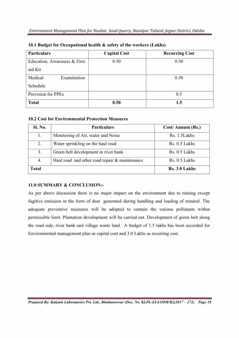
10.0 DETAILED BUDGET OF ENVIRONMENTAL MANAGEMENT PLAN
For implementation of Environmental Management Plan in the mining lease area, financial
estimates for year-wise expenditure (both capital and recurring) and action plan to maintain
better environment. The updated capital cost and recurring cost has been given in table below:
Environment Management Plan for Nuahat Sand Quarry, Rasulpur Tahasil, Jajpur District, Odisha
Prepared By: Kalyani Laboratories Pvt. Ltd., Bhubaneswar (Doc. No. KLPL-EIA/(MM/B2)2017 – 272) Page 18
10.1 Budget for Occupational health & safety of the workers (Lakhs)
Particulars Capital Cost Recurring Cost
Education, Awareness & First
aid Kit
0.50 0.50
Medical Examination
Schedule
0.50
Provision for PPEs 0.5
Total 0.50 1.5
10.2 Cost for Environmental Protection Measures
Sl. No. Particulars Cost/ Annum (Rs.)
1. Monitoring of Air, water and Noise Rs. 1.5Lakhs
2. Water sprinkling on the haul road Rs. 0.5 Lakhs
3. Green belt development in river bank Rs. 0.5 Lakhs
4. Haul road and other road repair & maintenance Rs. 0.5 Lakhs
Total Rs. 3.0 Lakhs
11.0 SUMMARY & CONCLUSION:-
As per above discussion there is no major impact on the environment due to mining except
fugitive emission in the form of dust generated during handling and loading of mineral. The
adequate preventive measures will be adopted to contain the various pollutants within
permissible limit. Plantation development will be carried out. Development of green belt along
the road side, river bank and village waste land. A budget of 1.5 lakhs has been accorded for
Environmental management plan as capital cost and 3.0 Lakhs as recurring cost.
Environment Management Plan for Nuahat Sand Quarry, Rasulpur Tahasil, Jajpur District, Odisha
Prepared By: Kalyani Laboratories Pvt. Ltd., Bhubaneswar (Doc. No. KLPL-EIA/(MM/B2)2017 – 272) Page 19
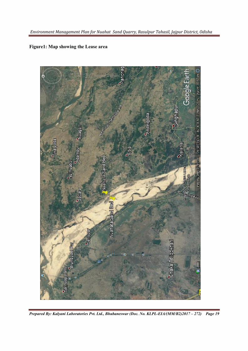
Figure1: Map showing the Lease area