Embed Size (px)
Citation preview
1
2
39
Anthropogenic Impacts on Urban Coastal Lagoons in the Western and
North-western Coastal Zones of Sri Lanka
Jinadasa Katupotha
Department of Geography, University of Sri Jayewardenepura
Gangodawila, Nugegoda 10250, Sri Lanka
Abstract
Six lagoons from Negombo to Puttalam, along the Western and North Western coast of Sri Lanka,
show signs of some change due to urbanization-related anthropological activities. Identified
activities have direct implications on morphological features of lagoons, elimination of wetlands
(mangrove swamps and marshy lands) and pasture lands, land degradation due to encroachment
for shrimp farms, shrinking of lagoons, and production of higher nutrient and heavy metal loads,
decline in bird and fish populations and degradation of the scenic beauty. As a result, the lagoon
ecosystems have suffered to such a degree that numerous faunal and floral species have
disappeared or have diminished considerably over the last few years. All these anthropogenic
impacts were identified by the author during 1992, 2002, and 2006 as well as in a study on
“Lagoons in Sri Lanka” conducted by IWMI between 2011 and 2012.
Key words: Anthropogenic Impacts, Urban Coastal Lagoons, Garbage accumulation, Awareness
program
Introduction
The island of Sri Lanka has 82 coastal lagoons that support a variety of plants and animals, and the
economy [1]. Anthropogenic impacts, particularly lagoon fishing, human occupation of the land and water
contamination have considerably reduced the faunal and floral population to a point that some of them
are in danger of extinction. Such danger of extinction has been accelerated in urban lagoons of the
western and northwestern coastal zones, e.g. Negombo, Gembarandiya, Chilaw, Muthupantiya, Mundal
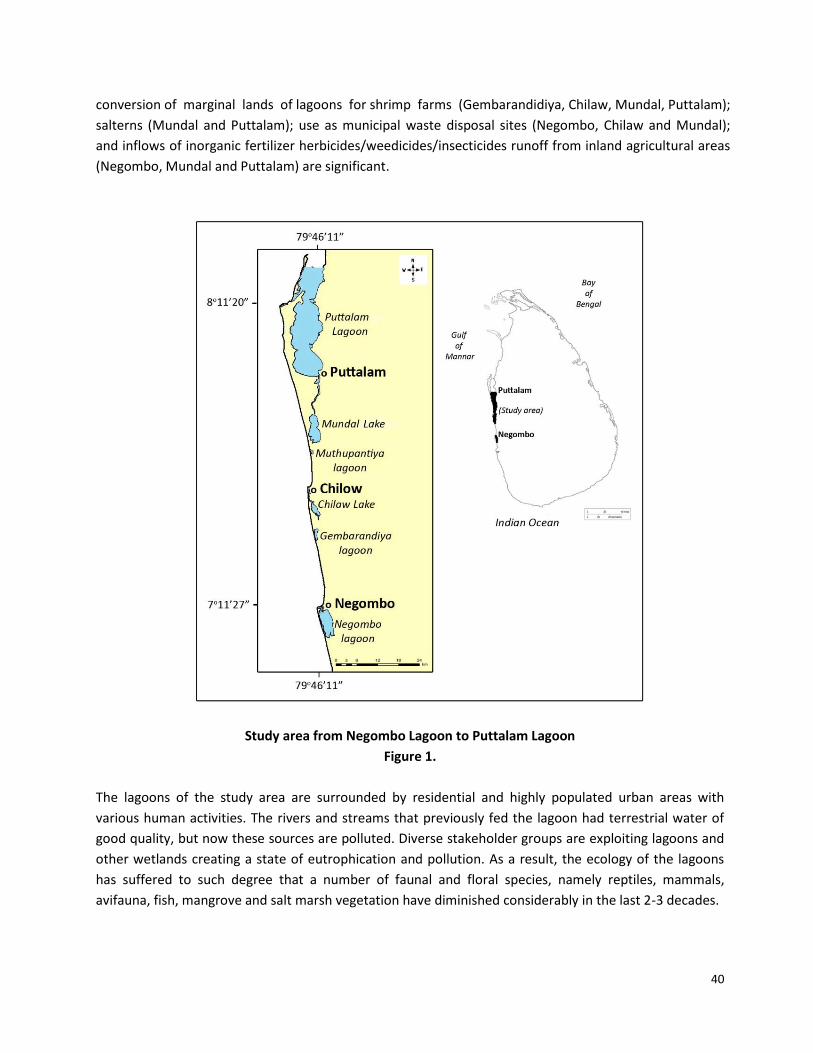
and Puttalam. These are water bodies with a total 432.87 km2 [1] where the present study was
conducted emphasizing such anthropogenic impacts, especially from Negombo Lagoon to Puttalam
Lagoon (Figure 1). Issues related to anthropogenic activities, the development of urban centers on
both sides along the Negombo Lagoon to Puttalam Lagoon are prominent. Among the other impacts
are the use as fishing anchorages and high density of fishing crafts (Negombo, Chilaw and Puttalam
Lagoons); land reclamation for road construction, settlements, expansion of agriculture (all Lagoons);
40
conversion of marginal lands of lagoons for shrimp farms (Gembarandidiya, Chilaw, Mundal, Puttalam);
salterns (Mundal and Puttalam); use as municipal waste disposal sites (Negombo, Chilaw and Mundal);
and inflows of inorganic fertilizer herbicides/weedicides/insecticides runoff from inland agricultural areas
(Negombo, Mundal and Puttalam) are significant.
Study area from Negombo Lagoon to Puttalam Lagoon
Figure 1.
The lagoons of the study area are surrounded by residential and highly populated urban areas with
various human activities. The rivers and streams that previously fed the lagoon had terrestrial water of
good quality, but now these sources are polluted. Diverse stakeholder groups are exploiting lagoons and
other wetlands creating a state of eutrophication and pollution. As a result, the ecology of the lagoons
has suffered to such degree that a number of faunal and floral species, namely reptiles, mammals,
avifauna, fish, mangrove and salt marsh vegetation have diminished considerably in the last 2-3 decades.
41
The infective anthropogenic activities are not unique to the bodies of water of the study area, but the
selected lagoons in the west and northwestern coastal zone have shown excessive levels of nitrates and
phosphates, increasing levels of salinity, heavy metals and hydrocarbons [2], [3], [4] and [5]. Studies of
urban lagoons have shown that pluvial water is an important instrument in the introduction of heavy
metals and organic compounds to their waters. Some of the main sources of these contaminants are the
rusted laminated roofs and weather proof insulations and street sewers that carry oil and combustion
particles [6]. Other sources are automobiles, fishing crafts and different sizes of automobiles and fishing
crafts repairing centres as well as runoff from agricultural areas. But it is not very easy to measure and
calculate such pollutants in our lagoons. Gamboa-Rodríguez et al [6] pointed out that there are other
factors that deserve to be studied such as winds, rains, geomorphology, subterranean waters,
phytoplankton etc., which too have a great importance in determining the behaviour of heavy metals and
pollution. Therefore, Gamboa-Rodríguez et al [6] analyze metals dissolved in the water from Las Ilusiones
lagoon, located in Villahermosa city, Mexico. Water samples taken from different sites in the lagoon were
analyzed to determine the content of lead, chromium, manganese, nickel and zinc using atomic
absorption spectroscopy. Results showed values significantly above the detection limits for some of these
metals, namely lead and zinc. The presence of these metals can be explained by pluvial discharges from
the city around the lagoon that wash rusted metal roofs and carry domestic discharge, paint and roof
insulation debris from buildings as well as oils and combustion particles from automobiles. The present
study highlights similar issues related to anthropogenic impacts on lagoons in Sri Lanka and tries to reveal
the consequences of these impacts.
1.1 Research Methodology
During the field visits for “Human impact on wetland ecosystems” [7], “Vulnerability of land use to
environmental impacts” [8], “Palaeoenvironmental evidence in North-West Sri Lanka [9] and for IWMI
study by Silva et al [1], between November 2011 and March 2012, lagoon communities in the study area
were consulted to understand their dependency on lagoons and to identify issues related to
anthropogenic activities. Identified issues and anthropogenic activities have a direct relationship with
morphological features and dimensions of various artificial structures of selected lagoons. The main
morphological features were measured using Google Earth path and line ruler. Coordinates taken in situ,
using GPS (GARMIN Etrex), and were compared with Google readings for accuracy. The area of the lagoon
was calculated using Arc GIS 9 (Arc Map Version 9.3) package whereas shoreline development (DL) was
computed by Microsoft Excel using the formula DL = L/(2*√π*Ao); where L and Ao are perimeter and
surface area, respectively [1]. The IWMI study (Silva et al 2013) estimated freshwater inputs to coastal
lagoons using available information on river discharges and also basin dimensions. Basin characteristics
were correlated to explain the magnitude of flow regulation.
1. Geographical setting of the study area
Sri Lanka is a tropical island with wave dominated micro-tidal coasts. The coast of this island harbours a
fair number of coastal water bodies. Coastal lagoons in Sri Lanka are shallow, shore parallel water bodies,
42
separated from the ocean by barriers or barrier spits, perennially or seasonally tidal and connected to the
sea through one or more restricted entrances. A majority of them are incorrectly categorized as ‘basin
estuaries’ without considering their origin and evolution. But a recent, benchmark study was conducted
in order to understand the formation and evolution of coastal lagoons in Sri Lanka (Silva et al 2013). This
study points out that there are eighty two lagoons skirted by 3032 km perimeter on the 1338 km
coastline of the island which amount to a total extent of 1536 km2. In the study area, from Negombo to
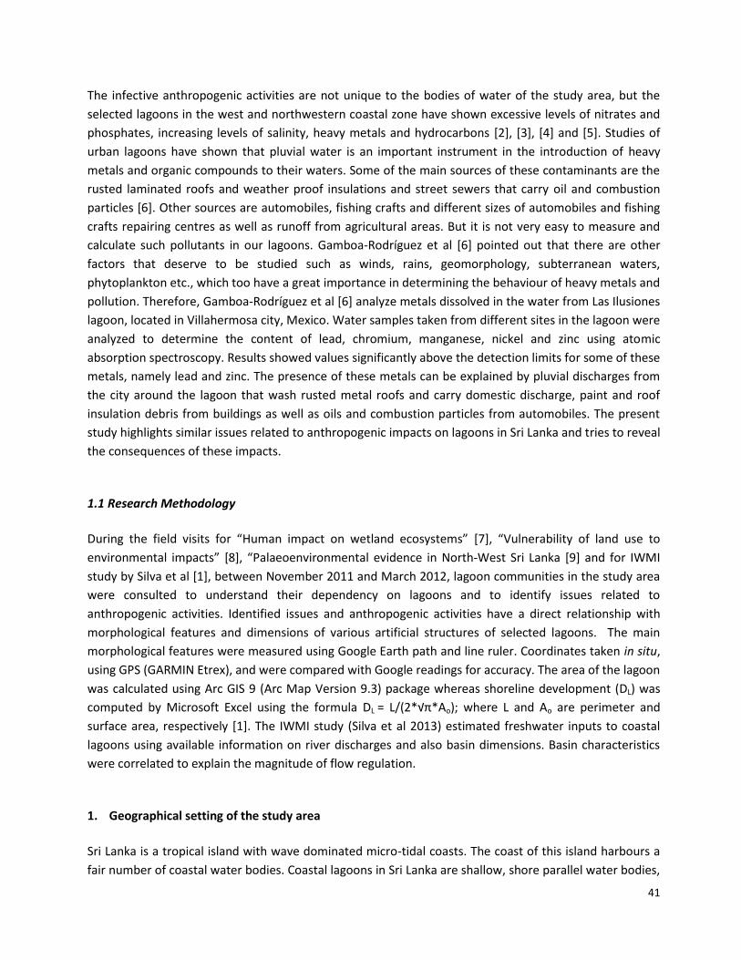
Puttalam, six lagoons have 432.87 km2 (Figure 1 and Table 1).
Location (coordinates) and some physical parameters in lagoons of the study area
Name of the
Lagoon
Longitude Latitude A
(km2)
PM
(km)
SLD AEZ WME
(km)
1.Negombo 7°12' 31"N 79°49
39"E
33.34 101.31 15.55 WL3-
WL4
0.404
2. Gembarandiya 7°25' 57"N 79°48'
39"E
2.41 13.86 7.91 IL1 0.610
3. Chilaw 7° 36' 24"N 79°47'
13"E
7.21 44.59 14.71 IL1 0.254
4. Muthupanthiya 7°43' 47"N
79°47'
36"E 0.71 5.94 6.25 IL1 0.065
5.Mundal Lake 7° 44' 57"N
79°47'
24"E 31.5 75.59 11.94 DL3 0.150
6. Puttalam 8° 23' 01"N 79° 48'
3"E
357.7 263.9 12.89 DL3 6.562
A = Area, PM = Perimeter, SLD = Shoreline development, AEZ = Agroecological Zone, WME =
Width mean entrance. Source: [1].
Table 1
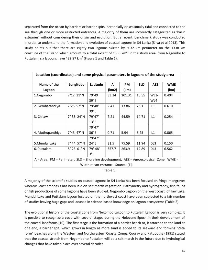
A majority of the scientific studies on coastal lagoons in Sri Lanka has been focused on fringe mangroves
whereas least emphasis has been laid on salt marsh vegetation. Bathymetry and hydrography, fish fauna
or fish productions of some lagoons have been studied. Negombo Lagoon on the west coast, Chilaw Lake,
Mundal Lake and Puttalam lagoon located on the northwest coast have been subjected to a fair number
of studies leaving huge gaps and lacunae in science-based knowledge on lagoon ecosystems (Table 2).
The evolutional history of the coastal zone from Negombo Lagoon to Puttalam Lagoon is very complex. It
is possible to recognize a cycle with several stages during the Holocene Epoch in their development of
the coastal landforms [10]. The first stage is the formation of a barrier beach or, it attached to the land at
one end, a barrier spit, which grows in length as more sand is added to its seaward end forming “Zeta
form” beaches along the Western and Northwestern Coastal Zones. Cooray and Katupotha (1991) stated
that the coastal stretch from Negombo to Puttalam will be a salt marsh in the future due to hydrological
changes that have taken place over several decades.
43
In several places beach-rock shoals are extending, for example around Colombo and Kelani River cut off
former mouth to Deduru Oya mouth and these have been formed by the lowering of sea level during the
Late Holocene Epoch [11], and they protect the Negombo and Chilaw lagoons from severe southwest
monsoon winds and ocean waves. The landward side of the study area is covered by Red-Yellow Podzolic
Soils with soft or hard laterite. Lagoon beds and surrounding marshes are underlain on Bog and Half-Bog
Soils. Along the coast, the lagoons and their surrounding marshes discontinue the relationship with the
sea by Latosols and Regosols on old Red and yellow sand [12]. Miocene limestone deposits are found as
basement rocks from Deduru Oya mouth to northwards (Katupotha and Dias [13].
Table 2
The coastal area under this study has a tropical climate and is subject to the annual weather cycle in the
country. The south-west monsoon (from May to August) brings rains to the southern and western coastal
regions, and the Central Hill country. The dry season in these regions is from December to March; the
north-east monsoon (from October to January), brings rain to the north and east of the island. This is
weaker and shorter-lived than the southwest monsoon whilst there are also two inter-monsoon periods
in October and November and in March and April respectively, when rain and thunderstorms can occur in
many parts of the country [13]. These climatic features have consequences for fisheries and marine
resources as well as for lagoon ecosystems.
Hydrographic parameters such as depth contours, temperature, salinity, pH, visibility, and stratification of
a lagoon are determined by morphometric, climatic, hydrological, and watershed characteristics of the
lagoon and tidal fluxes and wave actions of the adjacent ocean. Of the climatic parameters, the direction
and the magnitude of winds play an important role with respect to mixing, stratification, oceanic
currents, water movement and littoral erosion and, in turn, nutrient dynamics and primary productivity
[14] and [15]. Therefore, the configuration of the lagoon and the alignment of its fetch with monsoonal
Science-based Information on Lagoons in the study area.
Lagoon: West and
Northwestern Coast BM HG NT PP PL BT FH SG MG SM AF
1. Negombo x x x x x x x x x
2. Gembarandiya
3. Chilaw x x x x
4. Muthupanthiya
5. Mundal x x x x x x x x x x x
6. Puttalam x x x x x x x x
Bathymetry = BM, Hydrography = HG, Nutrients = NT, Primary Production = PP, Plankton = PL, Benthos
= BT, Fish-FS, Sea-grass = SG, Mangroves = MG, Salt Marches = SM. Source [1]
44
wind direction are also important in tropical countries experiencing monsoonal wind. The importance of
hydrography on water chemistry and nutrient dynamics are also very significant [1].
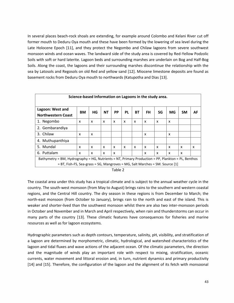
The seas around Sri Lanka are micro-tidal and predominantly semi-diurnal. The rise and fall of the tides is
within 0.7 m at spring tides and 0.05m at neap tides [14], [11] and [15]. The highest tidal range is
generally around Colombo (west coast), while the lowest is around Delft and Trincomalee (east coast).
This small tidal range forms little change in the level of water in most lagoonal inlets, leading to the
formation of mudflats and mud banks, and helps the existence of mangrove ecosystem, and prominent
salinity layers develop in deep areas of Puttalam Lagoon under calm conditions (Table 3, Arulananthan
2004).
Table 3
2. Result and discussion
Anthropogenic impact on urban lagoon is not only limited to Sri Lanka. Gamboa-Rodríguez et al [6]
recently shows that without a steady source of water, contaminants inflowing a lagoon through residual
and pluvial water drain from populated areas that surround it, and garbage accumulated on the banks of
the lagoon, have caused an alteration in its auto-purification capacity, producing eutrophication of its
waters (based on Las Ilusiones lagoon located in Villahermosa city, Mexico). Likewise, Briton Bi et al [17]
evaluated the Abidjan lagoon pollution emphasizing the physicochemical and biochemical characteristics
of effluents pouring into it. Further Briton Bi et al [17] state that the demographic pressure of the town of
Abidjan, is appeared in great part at the origin of many environmental problems. The lagoon which
crosses the city receives the industrial and domestic wastewaters coming from various districts of the
city.
Salinity levels and average depths of the lagoons in the selected area, Source [1]
Name of the
Lagoon
A (km2) Entrance Middle Inflow Area Depth
(m)
1. Negombo 33.34 4.5 33.8 0 30.2 0 6.5 < 2.0
2. Gembarandiya 2.41 - - - - - - -
3. Chilaw 7.21 - - 0 35.4 - - 1.1
4. Muthupanthiya 0.71
5. Mundal Lake 31.5 20 55 9 109 22 34 1.2
6. Puttalam 357.7 22 36 22 34 4 40 < 4.5
45
During the past 2-3 decades severe changes occurred along the western and northwestern coastal zones
of Sri Lanka influencing the depredation of lagoon ecosystems in ways very similar to those in Mexico and
West Africa, and also other urban lagoons in the world due to the increase of population pressure;
development of Metropolises; industrial and commercial zones and agricultural practices. In the Sri
Lankan context,
a) Rapid urban development on both sides of the Negombo, Chilaw and Puttalam lagoons and
Mundal Lake (by Bopitiya, Pamunugama, Pitipana, Ja-Ela, Katunayaka, Negombo, Marawila,
Koswadiya, Mahawewa, Mattakotuwa, Toduwawa, Kakkapalliya, Chilaw, Arachchikattuwa,
Battulu Oya, Udappuwa, Polichchikulama, Mundalama, Kottantivu, Madurankuli,
Mukkutoduwawa, Nuraicholai, Palavi, Puttalam townships and Ekala and Katunayaka Free Trade
Zones)
b) Establishment of anchorages and landing of a large number of fishing craft, including Multi-day
boats in Negombo, Chilaw and Puttalam Lagoons
c) Land reclamation for road construction, settlements and expansion of agriculture in Negombo,
Gembarandiya, Muthupantiya, and Puttalam lagoons and Mundal Lake
d) Conversion of marginal lands into shrimp farm ponds in Gembarandidiya, Chilaw, Muthipanthiya
and Puttalam lagoons and Mundal Lake, and in addition into salterns in Puttalam lagoon and
Mundal Lake
e) Use as municipal solid waste disposal sites (e.g., Negombo and Chilaw lagoons)
f) Inflows of inorganic fertilizer, herbicides/weedicides/insecticide runoff from inland agricultural
areas (Negombo, Mundal and Puttalam areas)
The Negombo Lagoon has an area of 33.88 km2 (Table 1), which connection to the sea is by a single
narrow opening at its northern end. There is dispersed freshwater input through the marsh at the
southern end by Dandugam Oya (Attanagalu Oya), J-Ela and Hamilton Canal, particularly during the rainy
seasons centred on April and October. Salinity ranges of the Negombo Lagoon area are shown in Table 3.
Most of the lagoon perimeter is fringed mangrove dominated by Rhizophora spp, Bruguiera spp,
Avicennia marina and Lumnitzera racemosa; also lagoon bed is dominated by Halodule, Zostera,
halassiodendron, Najas and Padina. It is an important area for a wide variety of waterfowl including
resident species of cormorants, herons and egrets, and migratory species of shorebirds, gulls and terns.
46
The rich fish fauna includes Mullets (Mugil spp), Etroplus suratensis, and a popular aquarium fish
indigenous to Sri Lanka. Invertebrates include a wide variety of polychaetes and molluscs, the crabs Scylla
serrata, Portunus pelagicus, and prawns of the genera Penaeus and Metapenaeus [18, [19 and [1].
Development of Fishery and Management Plan (DFMP) for Negombo Lagoon (2012) shows that there are
11 species of true mangroves in the Negombo Lagoon, and the extension has been reduced by 10%
during the period between 1981 and 1992.
Establishment of anchorages and landing of a large number of fishing craft including multi-day
boats are continuing in Negombo lagoon. Polluted water due to anthropogenic activities has completely
destroyed the fringe mangroves for housing projects, firewood and poles. Further, such destruction has
extended to seagrass beds, marshes and mudflat habitations. The DFMP Report (2012) indicates that
about 250 kg of coliform is added to the Negombo lagoon from the canal area and about 90 tons are
added per year from the western margin of the lagoon. This amount is released by 2000 families who do
not have sanitary facilities. Further, this report emphasized that in 2005, there were 943 illegal houses
along the Negombo Canal. Beside the above, all off-cuts of the Dry Fish Industry are removed to the
lagoon especially from Pitipana and Duwa areas. Likewise, off cut some parts of the fish are used for
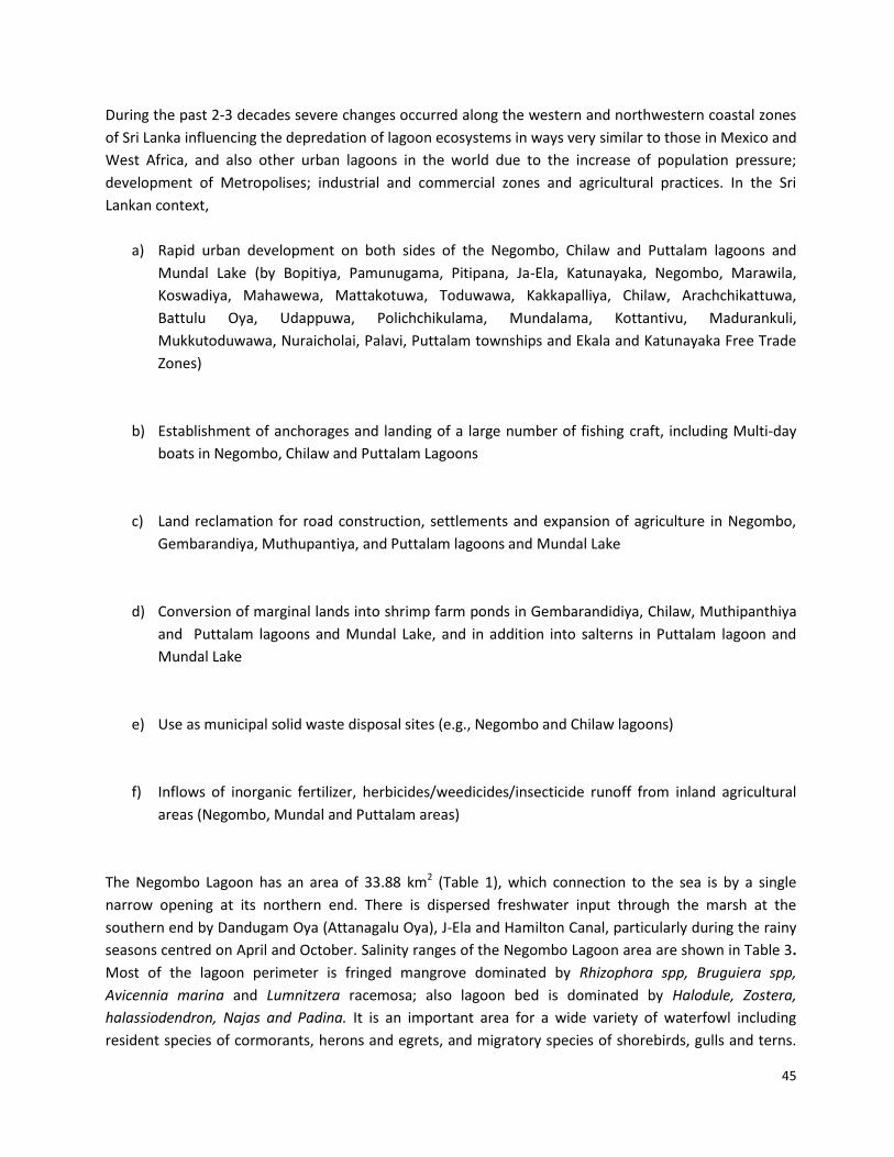
“Crab Cages”. Similarly, off cuts and other debris and blood of fish directly adds to the lagoon
(Photographs 1 and 2)' By these means lagoon water becomes polluted affecting the livelihood of lagoon
fishermen (DFMP Report 2012).
Water pollution occurs due to remove the garbage, oil from fishing craft, fish off cuts, debris and
bloods directly to the Negombo lagoon
Photograph 1 Photograph 2
Similarly, the land reclamation for road construction, settlements, rice paddies, grassland and coconut
plantations; conversion of marginal lands for shrimp farm ponds; encroachment of associated wetland,
including Muthurajawela by private companies, use the area as private and municipal solid waste
47
disposal sites and inflows of polluted terrestrial water from inland agricultural and industrial areas are
the main anthropogenic impacts. Illicit manufacture of liquor can be identified as other threats.
Due to above impacts, nutrient overload and breakdown of chemical cycling occur in all lagoons.
Reduction of water depths in the narrow inlet/exit channels of the lagoon, sedimentation leads to
reduction in the tidal exchange and flushing, which decreases the lagoon’s water quality. This has
resulted in the increased growth of the filamentous green algal Chaetmorpha spp. The algal is an
indicator of the presence of high levels of nutrients in an estuary [5]. Further, Lagerblad emphasizes that
the levels of organic matter (measured as BOD and COD), nutrients, pathogens and suspended solids in
Dandugam Oya are very high. Phosphorus and nitrogen can all cause lack of oxygen. This could be arising
from industries and uncontrolled domestic sewage, which gradually mix with lagoon water.
Gembarandiya is a small lagoon with 2.41km2. There is no science based information in relation to this
lagoon, and it appears as neglected wetland. However, Senadheera and Pathiratne [3] have discussed the
toxic heavy metal levels in northwestern lagoons including Gembarandiya. This lagoon has extensive
mangrove swamps. Much of the southern part of the lagoon has been converted into shrimp farm ponds.
The marginal wetlands associated with Gembarandiya Lagoon extend up to Toduwawa Mouth, which is
the southern part of the Chilaw Lagoon, completely encroached for construction of tourist hotels,
extending coconut cultivation and home gardens. Due to the formation of high berms at the lagoon
mouth, there is no movement of sea water in the lagoon. During the rainy season, terrestrial water
received by precipitation and floods by Lunu Oya a fresh water body gathers in the area. Informal
discussions with local people reveal that about 15 - 20 years ago, the lagoon supplied good prawn
harvests. But lack of moving sea water, pollutants from marginal lands, and activities of tourism and land
reclamation destroyed the lagoon ecosystem. As mentioned in Senadheera and Pathiratne (2005) such
activities would have increased the levels of lead, chromium and cadmium in the muscle tissue of the
shrimp.
Chilaw Lagoon is an intermittently closed lagoon on the northwest coast of Sri Lanka. The lagoon has 7.21
km2 [1] and the average width is 1.6 km. The lagoon is shallow with an average depth of 1.1m from MSL.
It is connected to the open ocean through two narrow and long restricting channels, located at the
extreme north and south ends of the lagoon. The length of the northern channel is 8 km with an average
width of 80 m and a mean depth of 1.5m. The southern entrance is already closed due to the formation
of high berm formation at the mouth at Thoduwawa. Even the northern entrance of the Deduru Oya may
close intermittently during the northeast monsoon. However, the mouths are generally kept open by
dredging to avoid floods upstream and also to allow for boat traffic. Over 7000 fishing boats daily pass
through the entrance of Chilaw Lagoon [21]. There are no rivers discharging directly into Chilaw Lagoon.
However, the lagoon occasionally receives freshwater from the Deduru Oya during periods of sandbar
formation at the Deduru Oya mouth and floodwater from the Demure Oya via Lunu Oya. Salinity ranges
of lagoons are shown in Table 3.
48
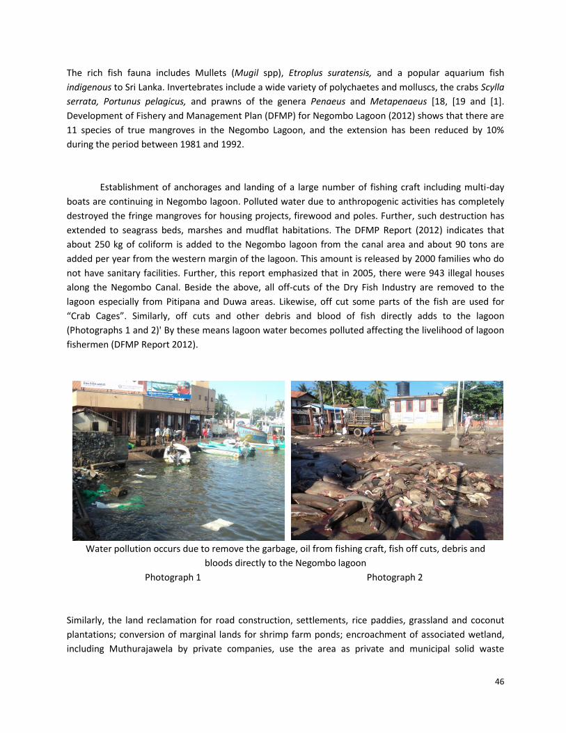
Chilaw is a bustling town with a famous fish market and beach. In the last few years, several hotel
developments have emerged in order to cater to the needs of tourists. Rapid urban development on both
sides of the Chilaw lagoon, establishment of anchorages and landing of a large number of fishing craft
and fish market are directly related with the lagoon' The photographs 3 and 4 show that the rapid
development of fishing activities and the fish market are evidently responsible for the removing of the
fringe mangroves, water pollution and illicit constructions. Similarly, clearing of mangroves for housing
projects, cutting for firewood, using as a shelter for the illicit manufacture of liquor and converting
mangrove patches for shrimp farm ponds are the major threats. All mud flats, marshes, patches of
mangrove swamps and other marginal lands at both ends of the Chilaw lagoon have been converted into
shrimp farm ponds. Such activities clearly impact on the lagoon water, fish population, avifauna and the
scenic beauty.
Expantion of fish market (Photograph 3) and landing of fishing craft
(Photograph 4) along the lagoon channel.
Photograph 3 Photographs 4
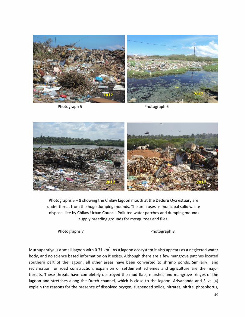
Likewise, the lagoon mouth at the Deduru Oya estuary is under considerable threat from the dumping of
urban refuses by Chailaw Urban Council (Photographs 5 - 8). During the rainy seasons sewage water is
added to the lagoon channel and flows up to the southern end. Such polluted water and refuse threaten
the mammals, reptiles, fish and avifauna in and surrounding areas of the lagoon. All these and especially
shrimp ponds can increase the levels of lead, chromium and cadmium in the Chilaw lagoon as mentioned
by Senadheera and Pathiratne [3]. Stagnant patches of water supply breeding grounds for dengue and
other mosquitoes'
2006 1992
49
Photograph 5 Photograph 6
Photographs 5 – 8 showing the Chilaw lagoon mouth at the Deduru Oya estuary are
under threat from the huge dumping mounds. The area uses as municipal solid waste
disposal site by Chilaw Urban Council. Polluted water patches and dumping mounds
supply breeding grounds for mosquitoes and flies.
Photographs 7 Photograph 8
Muthupantiya is a small lagoon with 0.71 km2. As a lagoon ecosystem it also appears as a neglected water
body, and no science based information on it exists. Although there are a few mangrove patches located
southern part of the lagoon, all other areas have been converted to shrimp ponds. Similarly, land
reclamation for road construction, expansion of settlement schemes and agriculture are the major
threats. These threats have completely destroyed the mud flats, marshes and mangrove fringes of the
lagoon and stretches along the Dutch channel, which is close to the lagoon. Ariyananda and Silva [4]
explain the reasons for the presence of dissolved oxygen, suspended solids, nitrates, nitrite, phosphorus,
2012 2012
2012 2012
50
COD (Chemical Oxygen Demand), BOD5 (Biological Oxygen Demand) and Chlorophyll-a from Deduru Oya
to Mundal Lake area including Muthupantiya Lagoon of extensive shrimp farming stretch.
Mundal Lake covers an area of 31.47 km2 [1] with an average depth of 0.75m. The western margin of the
Mundal Lake consists of a straight coastline with wide beaches, berms and sand dunes, while the old
raised dune ridges bound the eastern margin of the lake. The morphological sequence from west (sea) to
east, across the lagoon, consists of different landforms (Figure 2). But most of these are encroached,
removed and converted for various purposes. Accordingly, mundal Lake has no extensive mangrove
swamps. All surrounding lands have been converted into shrimp farm ponds. The boundary of the shrimp
ponds can be considered as co-extensive with the former lagoon boundary, about 30 - 35 years ago. The
lagoon and ponds are surrounded by a region containing rice paddies, coconut plantations and scrubland.
The rivers (from eastward) including three catchments namely, the Madurankuli Aru, the Kalagamu Oya
and the Ratambala Oya supply a considerable amount of terrestrial waters during the rainy season. The
tidal creeks stretch along the narrow corridor and both terrestrial and tidal water deposit layers of fine
silt and mud forming up of mud and thin tidal flats. The Tide Tables for the past 30-year period indicate
that the average tidal amplitude along the west coast is about 80 cm [11].
Extension of micro landforms from near-shore zone towards inland across Mundal
Lake and its environs. Source: [22]; modified by [9].
Figure 2
Salinity ranges of lagoons in the Mundal Lake area are shown in Table 3. Failure to receive sufficient
freshwater results in natural crystallization of salt during the dry season as occurs in many lagoons in the
A = Near-shore Zone (submerged), B = Dune sand (Holocene), C = Coarse sand with gravel, D = Lagoonal mud, E = Red Beds (Late Pleistocene), F= Well rounded gravel and pebble layer, G= Transported and/or weathered deposits mantled by windblown sand, H = well-compacted precipitated colloidal silica stratum (Late Miocene ?) and I = Weathered bedrock.
1 = Shallow near-shore zone, 2 = Coast line, 3 = Beach berms, 4 & 5 = Runnels, 6 – 9 = High dunes, 10 & 11 = Mud/Tidal flats, 12 = Mundal Lake, 13 = Mud/Tidal flats (inland), 14 = Dutch Canal, 15 = Chilaw – Puttalam Road, 16 = Red Beds ridge, 17 = Flood plain (paddy fields) and 18 = Low hills and rises (undulating terrain).
51
dry zone, which are categorized as hyper-saline salterns in the study area especially Mundal Lake. About
30 - 35 years ago, fertile patches of coconut lands were located along the sand barrier and old dune
ridges, while mangrove associates and salt marsh associates covered the edges of the lagoon and the
creeks. But introduction of new development activities such as aquaculture farms in recent years have
disturbed the existence of tidal and mud flats, destroyed mangrove patches and salt marshes on a large
scale to construct shrimp ponds are the main anthropogenic threats in the area. Damming and
destruction of the natural channel network providing water to ponds as well as discharging effluents
from the prawn ponds. Construction of dykes, canals, pipe lines and electric wire networks are the other
destructive activities [7]. Converting ridge and runnels and reclamation of mud flats as well as marshes
into shrimp ponds and the cultivation of coconut and other crops, and extraction of ground water
through deep wells to reduce the high salinity of the ponds are also responsible for raising a number of
social issues as well as water pollution in the area [7], [3] and [4]. Recent field observation revealed that
Marichchikattuwa village in Pubudugama GND and Kadayamotta area solid waste dumping sites. Water
pollution of the lagoon is obvious in those areas.
The Puttalam Lagoon is a large 319.97 km2 [1], and it is linked to Mundal Lake 15 km to the south by a
channel. The lagoon's water is brackish to saline. The lagoon has extensive mangroves, sea-grasses and
some salt marshes, attracting a wide variety of avifauna. This lagoon is one of the most productive ones
in the northwest coast of Sri Lanka with a water depth less than 1-2m, except in the central part of the
lagoon where a depth of 4.5 m has been recorded [23]. The tides on the west coast of Sri Lanka are
predominantly semidiurnal and relatively weak. The Puttalam lagoon receives fresh water from two
rivers, namely Kala Oya and Mee Oya whose average discharges were estimated to be about 2.2 m3/s and
8.1 m3/s respectively. Water and hydrological characteristics of lagoons receiving stream inputs in
relation to Puttalam Lagoon are shown in Table 2. Surface water salinities vary between 0 ppt at the river
discharge point to 55.0 ppt at the points away from the river discharge (Table 3). Establishment of
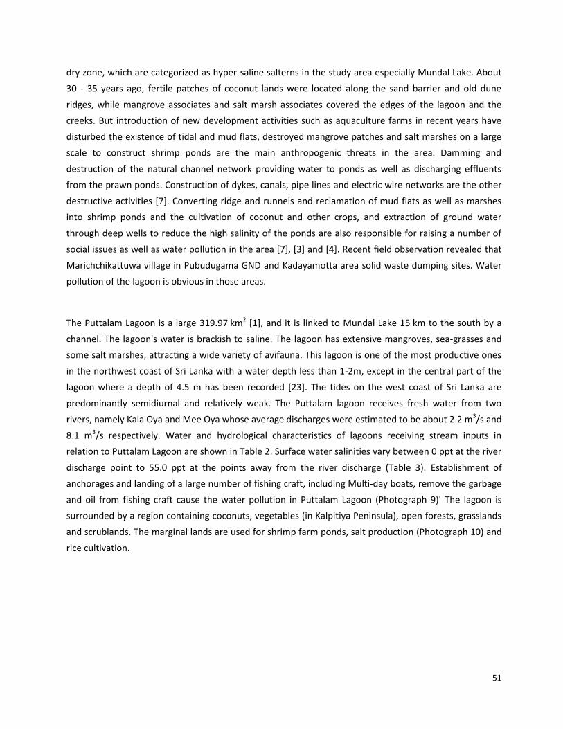
anchorages and landing of a large number of fishing craft, including Multi-day boats, remove the garbage
and oil from fishing craft cause the water pollution in Puttalam Lagoon (Photograph 9)' The lagoon is
surrounded by a region containing coconuts, vegetables (in Kalpitiya Peninsula), open forests, grasslands
and scrublands. The marginal lands are used for shrimp farm ponds, salt production (Photograph 10) and
rice cultivation.
52
Photograph 9 showing the fishing crafts and oil tanks western margin of the Puttalam
Lagoon and Photographs 10 showing the encroached land for salt production.
Photograph 9 Photograph 10
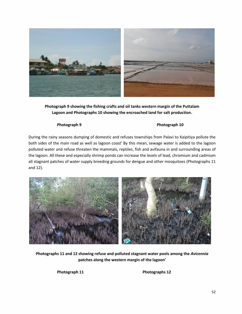
During the rainy seasons dumping of domestic and refuses townships from Palavi to Kaipitiya pollute the
both sides of the main road as well as lagoon coast' By this mean, sewage water is added to the lagoon
polluted water and refuse threaten the mammals, reptiles, fish and avifauna in and surrounding areas of
the lagoon. All these and especially shrimp ponds can increase the levels of lead, chromium and cadmium
all stagnant patches of water supply breeding grounds for dengue and other mosquitoes (Photographs 11
and 12).
Photographs 11 and 12 showing refuse and polluted stagnant water pools among the Avicennia
patches along the western margin of the lagoon'
Photograph 11 Photographs 12
53
The following consequences can be identified due to the anthropogenic impacts in all selected lagoons.
All those gangrene impacts create issues and problems from Negombo Lagoon to Puttalam Lagoon. Such
issues and problems are:
Pollution of well and ground water from shrimp farm activities,
Reduced groundwater table due to over extraction of water from tube/deep wells,
Reduced lagoon fish/crabs/prawns catch due to pollution,
Firewood loss due to mangrove clearance for shrimp farm ponds and agriculture
Restricted access to the lagoon for fishermen
Changing of the lagoon mouths and configuration,
Elimination of wetlands (mangrove swamps and marshy lands) and pasture lands
Shrinking of lagoon,
Production of higher nutrient and heavy metal loads,
Decline in avifauna, mammals and reptiles, and
Degradation of the scenic beauty of lagoons.
Pollution of lagoon water from wastewater from Negombo Lagoon to Puttalam Lagoon is the main issue.
The main reason for untreating wastewater from, industrial and domestic, is to eliminate any substances
that can cause harm to the environment and human life.[5] emphasized that the municipal sewage and
industrial wastewater contain readily biodegradable organic matter (measured as BOD, COD and TOC),
inorganic and organic chemicals, toxic substances and disease causing agents which are frequently
discharged into aquatic environments without treatment.
3 Conclusions
During the past 2-3 decades severe changes occurred in lagoons and associated wetlands along the
western and northwestern coastal zones of Sri Lanka due to urban development and population
pressure, unplanned tourist activities, establishment of infrastructure facilities and shrimp farm ponds.
These anthropogenic activities influenced the devastation of lagoon ecosystems in different ways very
similar to those in Mexico and West Africa, and also other urban lagoons in the world due to the increase
in population pressure, development of Metropolises, industrial and commercial zones and application of
new agricultural techniques. Accordingly, rapid urban development on both sides of the lagoons from
Negombo to Puttalam , establishment of anchorages and landing of a large number of fishing craft
including multi-day boats in Negombo and Puttalam Lagoons, land acquisition and requisition for road
construction, settlements and expansion of agriculture in all lagoon areas, conversion of marginal lands
into shrimp farm ponds (Gembarandidiya, Chilaw, Muthupamnthiya, Mundal and Puttalam) lagoons and
Lake and in addition into salterns in Mundal lake and Puttalam lagoon, use as municipal solid waste
disposal sites (e.g., Negombo lagoon, Chilaw and Mundal Lakes), and inflows of inorganic fertilizer
54
herbicides/weediside/insecticides runoff from inland agricultural areas (Negombo, Mundal and Puttalam)
are identified issues related to wide-ranging anthropogenic actions accountable for the existence of
dreadful conditions of lagoons in the study area. As mentioned in many research reports, pollution of
lagoon water by municipal sewage and industrial wastewater contains readily biodegradable organic
matter (measured as BOD, COD and TOC), inorganic and organic chemicals, and toxic substances. These
diseases cause agents, which are frequent, discharge into aquatic environments freely without
treatment. Release such substances that can cause harm to the environment and human life.
Therefore, it is highly desirable to organize awareness programs based on the “new knowledge”
generated by scientists on anthropogenic threats of urban coastal lagoons. Such programs should be
targeted at a wide range of stakeholders such as Government Officials, staff of Non-Governmental
Organizations, officers of Provincial Councils and Local authorities, Legal/Police Officers and school
children.
3. Acknowledgments
My profound thanks go to Dr. Herath Manthrithilake, Head, Sri Lanka Development Initiative,
International Water Management Institute, who gave me permission to extract some data and
information from lagoon study and Professor Ivan Silva for their pertinent suggestions.
4. References
1. Silva, E. I. L, Katupotha, J. Amarasinghe, O., Manthrithilake, H. Manthrithilake and
Ariyasena, R 2013. Lagoons of Sri Lanka: From the Origins to the Present. International
Water Management Institute (IWMI), Colombo, Sri Lanka. Do: 10.5337/2013.215 (2013).
2. Cattermoul, Nikola and Devendra, Aruna. A Measurement of the ecological footprint of
shrimp farming in the Chilaw Lagoon Area. Effective Management for Biodiversity
Conservation in Sri Lankan Coastal Wetlands, Fieldwork Report 2.3a:
3. Senadheera, S., Pathiratne, K.A.S 2005. Assessment of toxic heavy metal levels in black tiger
shrimp, Peneaus monodon [sic] Penaeus monodon cultured in the northwestern province of
Sri Lanka. Sri Lanka Journal of Aquatic Sciences, vol. 10, pp 45-54.
4. Ariyananda, T. N & Silva, E.I.I 1998. Water quality of brakishwater ecosystem from Deduru
Oya to Mundal Lake: area of extensive shrimp farming. In National Conference on Status
and future direction of Water Research in Sri Lanka, IWMI November, (1998).
55
5. Lagerblad, Lovisa 2010. Wastewater treatment wetlands – A case study in Colombo, Sri
Lanka. Arbetsgruppen för Tropisk Ekologi, Committee of Tropical Ecology, Uppsala
University, Sweden Minor Field Study 146 ISSN 1653-5634.
6. Gamboa-Rodríguez Tere, Gamboa-Adeco1 Roberto, Saldívar-Osorio Liliana & Gómez-Cruz1
Rodolfo 2012. Metals in water samples from an urban lagoon in Tabasco, Mexico, African
Journal of Environmental Science and Technology, vol. 6(3), pp 170-175.
7. Katupotha. J 2002. Human Impact on Wetland Ecosystems: A Case Study – The Mundel
Lake and Its Environs – Sri Lanka. Proceedings of the South Asia Regional Workshop on
Assessment of Material Fluxes to the Coastal Zone in South Asia and their impacts - A joint
APN/SASCOM/LOICZ workshop, 08-11 December, Negombo, Sri Lanka, pp 193-201
8. Katupotha, J 2006. Vulnerability of Land Use to Environmental Impacts: Evidence from the
Lower Deduru Oya (River) Basin, Sri Lanka. (Report submitted to Asia Foundation and
Green Movement of Sri Lanka).
9. Katupotha, J 2012. Palaeoenvironmental Evidence in North-West Sri Lanka: Evidence from
Mundal Lake and its surroundings. Paper presented at the Paleobiodiversity Symposium
organized by the Palaeobiodiversity Group, Biodiversity Secretariat, Ministry of
Environment, Colombo, Sri Lanka, 4 – December, pp. 98-109.
10. Cooray P.G & Katupotha, J 1991. Geological evolution of the coastal zone of Sri Lanka’. In
National Symposium on Causes of Coastal Erosion in Sri Lanka. CCD/GTZ, 9-11 February,
Colombo, Sri Lanka, pp 5-26.
11. Katupotha, J 1988. Evolution of coastal land form in the western part of Sri Lanka.
Geographical Science (Hiroshima Univ.), vol. 43(1), pp. 18-36.
12. Survey Department of Sri Lanka 2007. National Atlas of Sri Lanka (Second Edition). Climate,
and Soils, pp. 42-53.
13. Katupotha J. and Dias, P 2001. The geological evolution correlated to the stratigraphy of
the Kalpitiya peninsula. Journal of the Indian Association of Sedimentologists, Department
of Geology, University of Delhi, India (2001), vol. 20 (1), pp. 21-37.
14. Swan, B 1982. The Coastal Geomorphology of Sri Lanka: An Introductory Survey. Armidale,
N.S.W.
56
15. BOBLMEP/National Report Sri Lanka 2004. National Report of Sri Lanka on the Formulation
of a Tranboundary Diagnostic Analysis and Strategic Action Plan for the Bay of Bengal
Large Marine Ecosystem Programme. Leslie Joseph (Eds).
16. Arulananthan, K 2003. Hydrography, coastal water circulation and classification of Sri
Lankan lagoons, Ph.D. Thesis, PGIS News, 4, (2-4) December, Peradeniya, Sri Lanka.
17. Briton BI G. H., Yao, B & Ado, G 2006. Evaluation of the Abidjan lagoon pollution. Journal of
Applied Sciences & Environmental Management, vol, 10 (3), 175-181.
18. Kotagama, S.W., Pinto Leonard and Samarakoon Jayampathi L. Kotagama S.W 1989. A
Directory of Asian Wetlands by Derek A. Scott, pp. 583-634.
19. Sanders M., Jayawardena A., Ediriweera S 2000. Preliminary assessment for the shrimp
fisheries of the Negombo Lagoon (Sri Lanka). Food and Agriculture Organization of the
United Nations, Rome.
20. DFMP 2012. Development of Fishery and Management Plan (DFMP) for Negombo Lagoon.
unpublished report.
21. Wijeratne, E.M.S., Rydberg, L., Pathirana, K.P.P 2004. Modeling of Sea Levels, Water
Exchange and Dispersion in an Intermittently Closed Tidal Estuary: Chilaw Lagoon, West
Coast of Sri Lanka. Proceedings of the Tenth Asian Congress of Fluid Mechanics. Pp. 618-
625.
21. CEA 1994. Mundal Lake & Puttalam Corridor Channel (Wetland Site Report & Conservation
Management Plan).
23. Pathirana, K.P.P., Kamal, A.R.I., Riyas, M.C., Safeek, A.L.M 2008. Management Of Coastal
Resources In Puttalam Lagoon, Sri Lanka, COPEDEC VII, 2008, Dubai, UAE Paper No: P-06.


![Environmental Deterioration of the Tecomate Coastal Lagoon ...In tropical regions, the coastal lagoons are surrounded by a wide man-grove fringe [3]; this vegetation plays an important](https://img.pdfslide.us/doc/110x75/5e9e0359470e0840c75e5100/environmental-deterioration-of-the-tecomate-coastal-lagoon-in-tropical-regions.jpg)