Embed Size (px)
Citation preview
University of South FloridaScholar Commons
Graduate Theses and Dissertations Graduate School
3-28-2006
Coastal Processes and Anthropogenic FactorsInfluencing the Geomorphic Evolution of WeedonIsland, FloridaJeanne LambertUniversity of South Florida
Follow this and additional works at: http://scholarcommons.usf.edu/etd
Part of the American Studies Commons, and the Environmental Sciences Commons
This Thesis is brought to you for free and open access by the Graduate School at Scholar Commons. It has been accepted for inclusion in GraduateTheses and Dissertations by an authorized administrator of Scholar Commons. For more information, please contact [email protected].
Scholar Commons CitationLambert, Jeanne, "Coastal Processes and Anthropogenic Factors Influencing the Geomorphic Evolution of Weedon Island, Florida"(2006). Graduate Theses and Dissertations.http://scholarcommons.usf.edu/etd/3784
Coastal Processes and Anthropogenic Factors Influencing the Geomorphic Evolution of
Weedon Island, Florida
by
Jeanne Lambert
A thesis submitted in partial fulfillment
of the requirement of the degree
Master of Science
Department of Environmental Science and Policy
College of Arts and Sciences
University of South Florida
Major Professor: Eric Oches, Ph.D.
Philip Van Beynen, Ph.D.
Brent Weisman, Ph.D.
Date of Approval:
March 28, 2006
Keywords: geomorphology, sediment, Tampa Bay, shell midden, paleodune
© Copyright 2006, Jeanne Lambert

Acknowledgements
Thanks to The Friends of Weedon Island for financing 14
C dating, Progress
Energy for permission to access coring locations; Phyllis Kolianos and the Weedon
Island Preserve staff for obtaining permits and helping with field work; and Jonathan
Dean and Brent Weisman for their archaeological expertise. I would also like to thank
the coring crew, with special thanks to the constant members, Scott Anderson, Matt
O’Brien, and Dave Burns, as well as Jenn Sliko for her contributions and suggestions.
Thanks to Jason Polk, Dan Dye, Phil Van Beynen, and Rick Oches for putting up with
me and helping out on all the little problems along the way. Special thanks to my family
and friends who have been there for me, I could not have finished without your love,
guidance, sense of humor, and support.
i
Table of Contents
List of Tables iii
List of Figures iv
Abstract v
Introduction 1
Background
Site Location 4
Geologic Background 5
Sea level History 8
Paleoclimate 13
Archaeology of Weedon Island 16
Methods 21
Field Methods 21
Lab Methods 24
Results 26
Cores 26
Radiocarbon Dating 31
Aerial Photographs 37
Discussion 40
Fence Diagrams Descriptions 40
Fence Diagram A 40
Fence Diagram B 41
Fence Diagram C 42
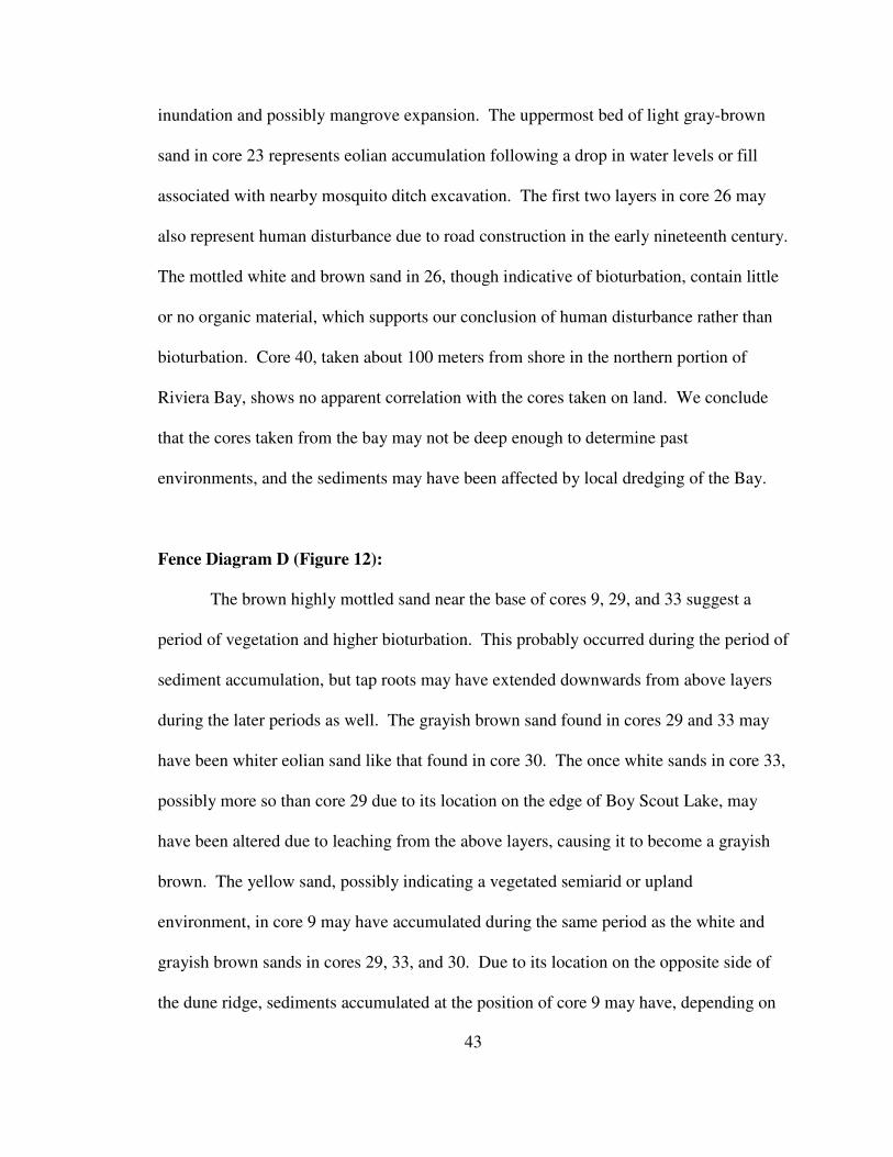
Fence Diagram D 43
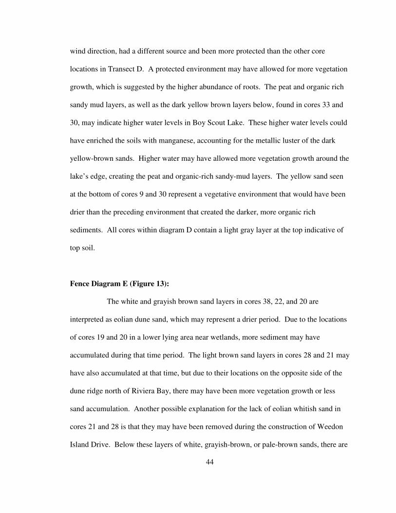
Fence Diagram E 44
Bed Interpretations 46
Comparison With Paleoclimate 48
Conclusion 52
References 54
Appendices 59
Appendix A: Core Digital Library 59
ii
List of Tables
Table 1 Core Data 23
Table 2 Facies Descriptions 29
Table 3 Radiocarbon Dates 31
iii
List of Figures
Figure 1. Site Location 6
Figure 2. Balsillie and Donoghue (2004) Sea Level Curve 10
Figure 3 Wanless Modified Sea Level Curve 11
Figure 4 Balsillie and Donoghue (2004) Sea Level Graph 12
Figure 5 Soto (2005) Oxygen Isotope Graph 15
Figure 6 Shell Tools Found on Weedon Island 19
Figure 7 Archaeological Shovel Pit Sites 21
Figure 8 Core Locations 27
Figure 9 Fence Diagram A 32
Figure 10 Fence Diagram B 33
Figure 11 Fence Diagram C 34
Figure 12 Fence Diagram D 35
Figure 13 Fence Diagram E 36
Figure 14 1943 Photograph with Paleoshoreline 38
Figure 15 1943 Photograph without Paleoshoreline 39
Figure 16 Paleoclimate Interpretation 49
iv
Coastal Processes and Anthropogenic Factors Influencing the Geomorphic Evolution of
Weedon Island, Florida
Jeanne Lambert
ABSTRACT
Weedon Island, a peninsula located on the western inner shoreline of Tampa Bay,
Florida, is the location of a collaborative geological and archaeological project that aims to
relate the present day geomorphology to natural processes and human occupational activity
during the middle to late Holocene. The area is known for extensive archaeological sites,
which were originally investigated in the 1920s, although they have received relatively
little scientific attention during most of the last century. We hypothesize that activities
associated with pre-historic human occupation of Weedon Island at various times during
the last ca. 5,000 years influenced the geomorphic evolution of the peninsula. An
interdisciplinary approach, including geomorphic mapping, sediment-coring, and
archaeological survey and excavation, is being used to test our hypothesis and is expected
to reveal the extent to which natural processes and human activities interacted to shape the
present-day configuration of the peninsula.
A total of 41 vibra-cores have been recovered from Weedon Island in a series of
transects from Riviera Bay, an inland body of water connected by tidal channel to Tampa
Bay, across multiple dune ridges, depressions, freshwater wetlands, and forested uplands,
to the pre-development eastern shoreline position. Coring has revealed multiple buried
v
surfaces and archaeological midden deposits, which allow us to reconstruct the vertical
aggradation of coastal and inland sediments. Initial radiocarbon dating on charcoal
provides an age estimate of 1450 ± 40 14
C yr B.P. for the upper midden horizon. Wood
fragments from a sand layer at the base of the core give a pre-occupation age of 3370 ± 50
14C yr B.P. These dates and stratigraphic evaluations of sediment reveal possible
paleoenvironmental shifts associated with mid to late Holocene sea-level rise,
paleoclimatic shifts, and pre-historic human activity.
More recent human impacts on the peninsula have impeded our efforts in some
areas. During the twentieth century, dredging, mosquito ditching, and road construction,
have disturbed the surface and portions of the upper sediment record in many locations.
Sediments below obvious disturbances or in unimpacted areas of the peninsula, along with
radiocarbon dating, have helped reconstruct the mid to late Holocene paleoenvironments
and paleolandscape of Weedon Island.
1
Introduction
Weedon Island, a peninsula on Florida’s West coast, protrudes into the estuary of
Tampa Bay. Weedon Island is of geological and archaeological interest due to its
moderately well preserved (legendary) archaeological site and its placement in inner
Tampa Bay. The outer barrier island chain and shelf area at the opening of Tampa Bay
have been extensively researched (Davis, 2003), yet many regions within the bay have
received less attention. The post-glacial inundation history of Tampa Bay itself is still
somewhat in question, though a better understanding of the region has recently been
summarized by Donahue et al. (2003), suggesting a sunken fresh water depression that
was inundated by marine waters around 5,000 BP. Surveys on the inner bay may help
clarify times and patterns of sea level fluctuation and major events that may have
occurred within of Tampa Bay since marine inundation.
The area is also known for its variety of archaeological sites, which have
characterized a civilization of western Florida. Though the culture of the Weeden (sic)
Island peoples (Note: known as such due to a misspelling in 1920s archaeological
literature) has been established through artifacts from limited Weedon Island
archaeological excavations and excavations elsewhere, there was very little known about
the prehistoric people of the actual Weedon Island site (Milanich, 2002). Reconnaissance
archaeological surveys done in collaboration with our geomorphologic studies have
located and recorded a range of previously undocumented potential sites on Weedon
2
Island and revealed aboriginal technologies and occupational periods (Weisman et al.,
2005). Further knowledge of the area has been established through our geological survey
in which we reconstruct the geomorphic evolution of the peninsula during the late
Holocene to help understand the paleoenvironmental relationships pertaining to the
settlement patterns and timing of occupation events.
The purpose of this investigation is to reconstruct the geologic and
paleoenvironmental evolution of the Weedon Island peninsula as a context for the ancient
civilization’s movements on the peninsula itself.
Research Hypothesis: Prehistoric activities and cultural occupation and
paleoclimatic changes influenced the geomorphic evolution of Weedon Islands.
Supporting Research Questions:
1. How did changes in sea level affect the geomorphology and
sedimentation processes of Weedon Island?
2. What is the relationship between human manipulation of the landscape
and the natural sedimentation processes in the geomorphic evolution of
Weedon Island?
3. What additional research will be required to asses the anthropogenic
and paleoclimate effects on the island’s geomorphology.
Data from this investigation, through sediment core collection, demonstrate a
transition from a freshwater environment to a shallow brackish environment along the
paleoshoreline. This is evident in the mud and peat layers that rapidly transition to
3
shallow beach-face sands. In inland cores we saw evidence of transitions from upland
environments to more (saline/fresh) moist environments as well as transitions from arid
dunal environments to more vegetated soil types as the water table and sea level rose.
4
Background
Site Location
Present day Weedon Island (Figure 1) consists of a 3,700 acre preserve owned by
Pinellas County, the State of Florida, and Progress Energy Corp. The land has been
jointly managed by all three entities since 1992. The preserve holds a vast variety of
environments corresponding to upland, scrubland, and marsh ecosystems. Elevation
plays a key factor in the location of these ecosystems in the preserve. Dune complexes
surround Riviera Bay along its northern and eastern shores, Master’s Bayou on its
southern shore, and once flanked the paleoshoreline of western Tampa Bay. The rise of
these dunes from 2.5m to 6.5 m above sea level results in drastic differences in vegetation
and soils. Mangrove marshes and tidal flats comprise most of the southern portion of the
peninsula. Multiple springs and fresh to brackish lakes are located on the peninsula and
its bordering islands. The northeastern portion of the peninsula has extensive alterations
from the construction of the Florida Power electricity generating facility.
The island has undergone other historical changes due to fill activities, mosquito
ditches, and additional human alterations during the past century. Much of the area was
cleared of vegetation to harvest pine trees, build roads and an airport runway, and
construct houses and businesses during the late 19th
and early 20th
centuries. Portions of
the area were also utilized for agricultural development. Weedon Island residents,
including Dr. Weedon himself, planted citrus groves over much of the northern and
5
eastern-midden capped dune ridges, which altered the upper sediment layers. During the
1950s and 1960s extensive mosquito ditches were dug on the southern and northern
portions of the peninsula to “improve health”. The ditches drastically altered the ecology
and hydrology of the area, allowing marine waters and mangrove invasion into a once
upland environment in the northern portion, and a former mud flats ecosystem in the
south. There has also been significant looting of the archaeological sites throughout the
last century. Large conspicuous looting ditches can still be identified, especially along
the large northeastern midden complex excavated by Fewkes in 1924. All of these
historic and recent alterations have hampered our ability to reconstruct the past
environments of Weedon Island.
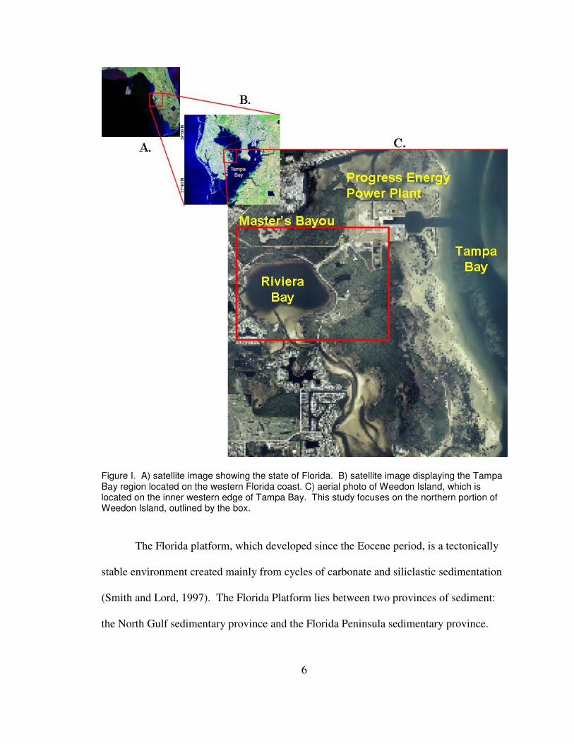
Geologic Background
Weedon Island is really not an island at all, as can be seen in Figure 1. It is a
peninsula located on the inner western edge of Tampa Bay. Tampa Bay is Florida’s
largest estuary, with a surface area of 1032 km2, and an average depth of less than 4
meters is located on the extensive Neogene carbonate Florida Platform (Duncan et al.,
2003; Donahue et al., 2003).
6
Figure I. A) satellite image showing the state of Florida. B) satellite image displaying the Tampa Bay region located on the western Florida coast. C) aerial photo of Weedon Island, which is located on the inner western edge of Tampa Bay. This study focuses on the northern portion of Weedon Island, outlined by the box.
The Florida platform, which developed since the Eocene period, is a tectonically
stable environment created mainly from cycles of carbonate and siliclastic sedimentation
(Smith and Lord, 1997). The Florida Platform lies between two provinces of sediment:
the North Gulf sedimentary province and the Florida Peninsula sedimentary province.
7
During the Holocene, sedimentary deposits consisted mainly of siliclastic, carbonate, and
organic sediments (Scott, 1997).
Throughout history, the Florida platform has been continually shaped and
reshaped by the inundation and retreat of the oceans (Hine, 1997). The gently sloping
platform, with a maximum elevation of 104 meters, allows for small sea level rises to
have great impacts on the environment of the region (Hine, 1997). Freshwater lakes turn
quickly into marine environments with the onslaught of rising sea levels, and when seas
subside, areas become exposed dry land (Beck, 1984). The rate at which the sea level
rises plays a crucial role in the development of coastal morphology (Schmidt, 1997).
The Tampa Bay region is a low energy sedimentation environment influenced
mainly by tides. Though the tidal range for the area is less than one meter, Tampa Bay,
because of its size, has an impressive tidal prism. These large prisms can greatly
influence the geomorphology of the estuary’s tidal inlets (Hine, 1997). Other influences
include impacts by tropical storms during the summer and frontal systems during the
winter (Davis et al., 2003). Although infrequent, hurricanes along Florida’s Gulf Coast
can play a major role in geomorphic changes of the area when they do occur (Davis et al.,
2003).
There are four general theories for the formation of Tampa Bay. Stahl (1969)
believed that the topography of the area may have had an impact on surface drainage
patterns. These patterns may have influenced erosion of local features to create the
Tampa Bay depression. Hebert (1985) believed the bay area was influenced more by
karstification of the Miocene valley system, which has been recognized on the shelf.
This caused the dissolution of limestone and the creation of depressions. Bathymetric
8
and seismic surveys on the coastal shelf help reveal the complex nature of this system,
and the theory was later expanded upon by Hine (1997).
Hine (1997) hypothesized that during periods of lowered sea levels and increased
water flow through the Tampa Bay system, the rates of dissolution of limestone may have
increased on the shelf-valley systems. This may have caused a receding shelf-valley
system and helped to create the present day Tampa Bay (Hine 1997). On the other hand,
Donahue et al. (2003) suggest that there is no evidence of an estuarine or shelf retreat
path. Instead they propose that the present Tampa Bay was a mid-platform depression
that contained freshwater wetlands and acted as a drainage basin for much of the central
peninsula. The freshwater depression system was quickly inundated by marine
transgression which flooded the area during the late Holocene.
Sea Level History
The rise and fall of sea level and the rate at which it occurs remains the central
issue to the theories for the formation of Tampa Bay described above. During glacial
periods a significant amount of water is stored in glaciers and snow cover in the higher
latitudes. In response, ocean levels decline, less precipitation falls in the subtropics,
causing the land to dry, and cooler ocean temperatures cause a reduction in evaporation
rates. The last major ice age maximum was around 20,000 years B.P., at which time sea-
level was as much as 140 m below present level. Since the ice sheets began retreating
about 15,000 years ago, sea-level has steadily risen, although with periods of minor
reversals and fluctuating rates documented in the geologic record.
9
Fairbridge’s (1974) sea-level curve, which is based on radiocarbon data and
geomorphologic evidence from around the world, shows a eustatic sea level height
similar to the present by about 6,000 years B.P. (Gleason, 1984). The actual height of the
oceans has changed very little in the last 3,500 years, oscillating a few feet since then, but
the volume has recently begun to increase (Dorsey, 1997). Robbin’s (1984) study in the
Florida Keys shows evidence of slow-fast-slow trend in the rates of rise. He suggests a
rate of rise of 0.3 mm/yr from 14,000 to 7,000 yrs B.P., 1.2 mm/yr from 7,000 to 2,000
yrs B.P. and 0.3 mm/yr from 2,000 yrs B.P to the present (Robbin, 1984). Scholl’s 1969
curve, based on radiocarbon-dated samples of peat from South Florida also shows a
constant overall sea level rise, but with varying rates (Gleason, 1984). Gleason (1984)
found a similar continuous sea level rise through his study of the Florida Keys. Some
investigations have suggested, mainly utilizing evidence from shell midden sites and
dune scarps, that there was a higher-than-present sea-level stand during the mid to late
Holocene (Blum et al. 2001; Morton et al., 2000; Stapor et al., 1991). In Gleason’s study
of the Keys, there was no evidence to suggest a higher than present sea level during the
Holocene. Closer to our study area, no higher than present mid-Holocene sea level stand
was found along the Suwannee River coastline, but varying rates of rise for the area were
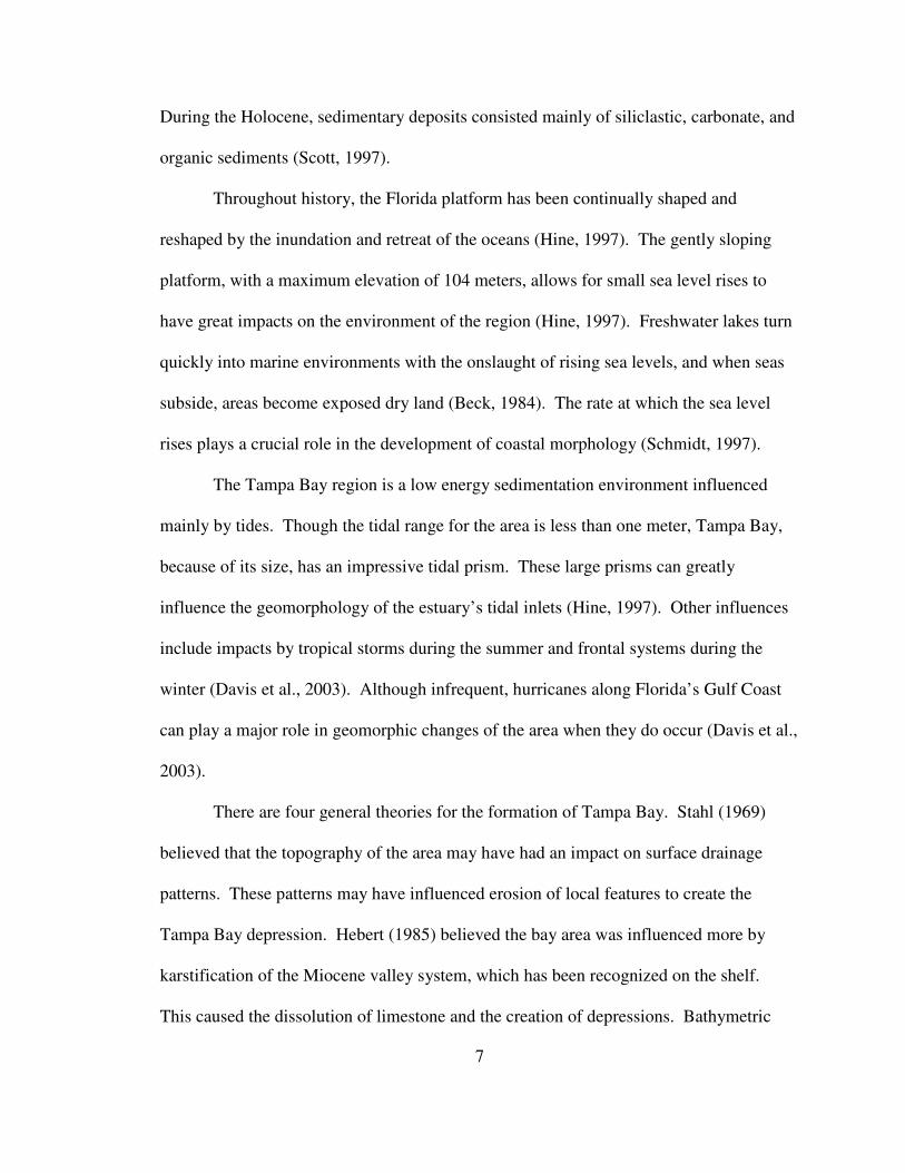
estimated (Wright et al. 2005). Figure 2 is a compilation of data from several studies
reconstructing changes in sea-level during the past 5,000 years.
10
-2
-1
0
1
2
3
4
5
6
7
8
0 1000 2000 3000 4000 5000 6000
DE
PT
H o
f M
SL
(m
)
C-14 years BP
(MSL) Scholl and Stuiver (1967) Stapor et al. (1991)
Froede (2002) Goodbred (1998) Walker (1994)
Fairbanks (1990)
Figure 2. Sea-level studies are represented by different colored lines and data points within the graph taken from Balsillie and Donoghue (2004). The data points and lines have been graphed to represent researched data for sea-level heights from present day to 5,000 yrs B.P.
Wright and others (2005), from their extensive study of the Suwannee River
region, established rates of sea-level rise for the stable northern Gulf Coast of Florida.
Using marsh deposits Wright and others identified a rate of rise for the area of 0.16 cm/yr
between 7,500 and 5,500 cal yr BP. The rise slowed to 0.07 cm/yr between 5,500 and
2,500 cal yr BP, and slowed even further to 0.05 cm/yr between 2,500 cal yr BP and 750
cal BP. Wanless (1994) also amassed information from a variety of sources to establish a
general sea level rate of rise curve for the coast of Florida. Figure 3 shows an overview
of his curve estimating sea level rate of rise for the West Coast of Florida over the
Holocene (Wanless, 1994).
11
Figure 3. The Holocene sea level rate of rise curve was compiled by Wanless et al. (1994), and illustrates the variations in the rate at which the sea is rising in South Florida. This graph was created using stratigraphic studies from throughout South Florida.
12
One of the most recent compilation efforts was done by the State of Florida
Environmental Protection Agency and the Florida Geological Survey. Balsillie and
Donoghue (2003) compiled 23 data sets from what are presently on shore and marine
locations. They then compared these two separate reconstructions with a global (eustatic)
sea-level curve. Figure 4 illustrates their findings for the middle to late Holocene.
Figure 4. Comparison of the Gulf of Mexico younger data set compiled by Balsillie and Donoghue (2003) with the Siddall et al. (2003) eustatic sea-level curve. The Younger data set A is a compilation of data from presently marine positions from 23 sources. The Younger data set B is a compilation of presently onshore data from 23 sources.
The variations in sea level and rates of change play a major role in the
geomorphic evolution of the coastline. All of the above research suggests that sea-level
has changed throughout the Holocene and that the rate at which it has changed has also
fluctuated. Donahue et al. (2003) postulated a model for the development of Tampa Bay
as sea level has fluctuated over the Holocene. The model shows Tampa Bay as a sunken
fresh water depression from 11,000 yr B.P. to around 5,000 yr B.P., when the depression
was quickly inundated by marine water. This created a shallow protected estuarine
13
environment suitable for mangrove and sea grass development. The rate of sea level rise
was more rapid (around 10m/1000yrs) until 3,000 yr B.P., when it slowed as it reached a
level near the present position, which correlates well with both Wanless (1994) and
Wright (2005) curves. The slow rate of rise allowed for sediment accumulation and
development of coastline features such as barrier islands and extensive mangrove
systems, which are seen along Florida’s west coast (Donahue, 2003). Thus far there is
very little information on how the sea level oscillations and rates of change have affected
the inner portion of Tampa Bay where Weedon Island is situated.
Paleoclimate
Present climatic conditions in the Tampa Bay area are representative of a
subtropical climate. The average summer and winter temperatures are 32°C and 17°C
degrees Celsius, respectfully, and the area has an average rainfall (exclusive of
hurricanes) of about 1170mm (NOAA Climate Data Center, 2006). More than half of the
precipitation occurs during the wet season which runs from June through September and
overlaps with the hurricane season (June-November). Precipitation in the region is
highly influenced by regional climatic factors such as El Nino, the location of the
Intertropical Convergence Zone (Cane, 2005), and the position of the Bermuda High
(Stahle and Cleveland, 1992).
Throughout the Holocene, changes in Florida’s climate have been influenced by
changes in the regional climatic features listed above. These features may themselves be
influenced by a variety of events following the last glaciation such as the Earth’s orbital
parameters (Milankovitch Cycles), and effects of deglaciation meltwaters flushing into
14
the Gulf of Mexico and the Northern Atlantic (Poore et al., 2003; Oglesby et al., 1998;
Curtis and Hodell, 1993). The lack of high resolution studies has impeded reconstruction
of a precise paleoclimate history for Florida during the Holocene (Otvos, 2005).
Previous studies have focused on lake sediment analysis and tree ring studies, such as
those at Camel Lake, Lake Tulane, and Little Salt Springs. The early Holocene is
characterized by drier and cooler conditions until around 8,500 yr B.P. (Poore et al.,
2003; Watts, 1980). A study at Little Salt Spring study indicates drier than present
conditions from between 9,300 and 5,900 yr B.P., a wet period beginning about 5,000 yr
B.P. until around 2,800 yr B.P., semi-arid conditions peaked between 2,700 and 1,900 yr
B.P., and precipitation once again increased, peaking at 1,000 yr B.P. (Alvarez et al.,
2005). The sediment record at Little Salt Spring is low resolution with considerable
uncertainty in the age estimates. But wetter conditions beginning at 5,000 yr B.P. do
correspond well with the increasing El Nino intensity beginning around the same time
(Cane, 2005).
A recent paleoclimate study in Florida, and the first one involving speleothem
isotopic analysis, confirms the tree ring precipitation models for the SE U.S. from 1,000
yr B.P. to the present (Soto, 2005). The speleothem record extends the tree ring record,
giving high resolution data on precipitation back to 4,200 years B.P. (Soto, 2005). Soto
(2005) found that the Atlantic Multidecadal Oscillation, with a cyclicity of about 60
years, appears to have the greatest impact on precipitation in Florida. Their study also
correlates well with the lake sediment studies listed above and estimated precipitation
variations as well as Cane’s (2005) study of El Nino events during the Holocene. Figure
15
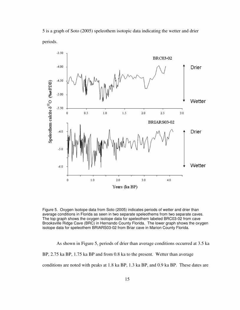
5 is a graph of Soto (2005) speleothem isotopic data indicating the wetter and drier
periods.
Figure 5. Oxygen Isotope data from Soto (2005) indicates periods of wetter and drier than average conditions in Florida as seen in two separate speleothems from two separate caves. The top graph shows the oxygen isotope data for speleothem labeled BRC03-02 from cave Brooksville Ridge Cave (BRC) in Hernando County Florida. The lower graph shows the oxygen isotope data for speleothem BRIARS03-02 from Briar cave in Marion County Florida.
As shown in Figure 5, periods of drier than average conditions occurred at 3.5 ka
BP, 2.75 ka BP, 1.75 ka BP and from 0.8 ka to the present. Wetter than average
conditions are noted with peaks at 1.8 ka BP, 1.3 ka BP, and 0.9 ka BP. These dates are
16
associated with larger peaks, but there are also many small oscillations, especially within
the more detailed BRIAR cave record. All but the drier period around 0.9 ka BP appear
to correlate well with the previous paleoclimate records described from Lake Tulane and
Camel Lake.
Archeology of Weedon Island
It has been estimated that humans arrived in Florida between 14,000 and 12,000
years B.P. (Milanich, 2002). Their impacts along the coast have been studied at many
locations. It is important to understand the role these ancient humans may have played in
the creation of Weedon Island as it exists today because of their possible impact on the
geomorphology of the area. A greater understanding of the archaeology of the area will
assist in the determination of occupational periods, which may correspond with particular
wet/dry periods and may have been influenced by sea level fluctuations.
The Weeden Island periods I and II are generally defined by their pottery types
and chronologically come after the Santa Rosa and Swift Creek Periods (Willey, 1949).
The two periods show general dates from A.D. 200/300 to 750 and A.D. 750 to 900-1000
(Milanich, 2002). The extent of the culture reaches down the Gulf Coast to Manatee and
Sarasota counties, northward to the coastal plains of southern Georgia and Alabama, east
to the Okefenokee swamp region, and west to Mobile Bay (Milanich, 2002). The sites
themselves generally were small in extent with typical diameters of less than 100 meters
(Willey, 1949). These sites were concentrated around sheltered brackish and salt water
environments, including coves, bays, lagoons, sounds, and estuaries (Milanich, 2002).
The socioeconomic structure was centered around the natural resources provided by the
17
coastal marshes and tidal streams such as mollusks and oysters, which are the
predominant shells found in middens (Milanich, 2002).
Weedon Island archaeology was explored and partially excavated in 1923-24, and
was reported by Fewkes (1924). His study found three basic different types of shell
mounds, which he labeled as burial mounds, rubbish mounds, and possibly domiciliary
mounds; but there is no direct evidence associated with the third type of mound as having
buildings on it. Fewkes (1924) postulated that the mounds themselves may have been
dunes previously, but evidence points towards artificial construction (Willey, 1949).
Most of the ceramics Fewkes found in the shell middens were plain ware. Therefore, he
did not associate the people who built the burial mounds and used Weeden Island pottery,
with those who lived in the village and used the plain pottery (Milanich, 2002).
Within the few excavation areas, it was determined by Stirling, who worked with
Fewkes on the excavation, that there are three distinct layers of deposition (Willey,
1949). These include a top layer about 4 inches in depth presumed to be deposited since
occupation, and 2 layers containing skeletal remains which show very different burial
techniques. Stirling believed the bottom layer to have been the original ground surface
where depositions of burials as well as pottery and non-ceramics were more depicting of
the Glades culture than the Weeden Island culture (Willey, 1949). The upper layer
collection of burials, pottery, and non-ceramics were more typical of the Weeden Island
II culture. The collection as a whole was incomplete, lacking information on any
Weeden Island I culture, and many artifacts are missing. There were not any numerical
ages determined, and therefore the time periods are only generalized (Willey, 1949).
18
These findings lead some archeologists to wonder whether or not Weedon Island itself
can be considered an actual “true” Weeden Island I site (Milanich, 2002).
A recent comprehensive cultural resource survey of the Weedon Island Preserve
by Weisman and others (2005), done in collaboration with this project, revealed a number
of possible human interactions with Weedon Island. They found the site to be of great
significance because, despite many disturbances, a substantial area of the site is still
preserved. These preserved deposits allow archaeologists to determine Late Manasota-
Weedon Island subsistence, technology, social organization, and political economy. A
great diversity of pottery in terms of style, temper, and potform were found on the site
leading to questions concerning pottery production and uses. Various tools were also
found amongst the sand layers. A significant reduction sequence not yet described
elsewhere in literature was worked out for a columella tool found on the site (Weisman et
al., 2005). Figure 6 shows some of these unique tools made from shells found on
Weedon Island by the cultural survey.
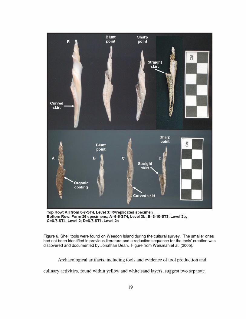
19
Figure 6. Shell tools were found on Weedon Island during the cultural survey. The smaller ones had not been identified in previous literature and a reduction sequence for the tools’ creation was discovered and documented by Jonathan Dean. Figure from Weisman et al. (2005).
Archaeological artifacts, including tools and evidence of tool production and
culinary activities, found within yellow and white sand layers, suggest two separate
20
occupational periods. Both the Late Archaic groups and the latter Manasota-Weedon
Island people lived on or adapted to a dunal setting. Those occurring within the yellow
sand layer have been associated with the Middle to Late Archaic Period occurring around
5,000 years ago. The white sand layer overlaying the yellow sand contains artifacts
indicating that people (Manasota-Weedon Island) were inhabiting the dune ridges during
and after deposition. Shell scatters within white sand layers may have occurred prior to
midden deposition, which occur predominantly above the white sand layer (Dean,
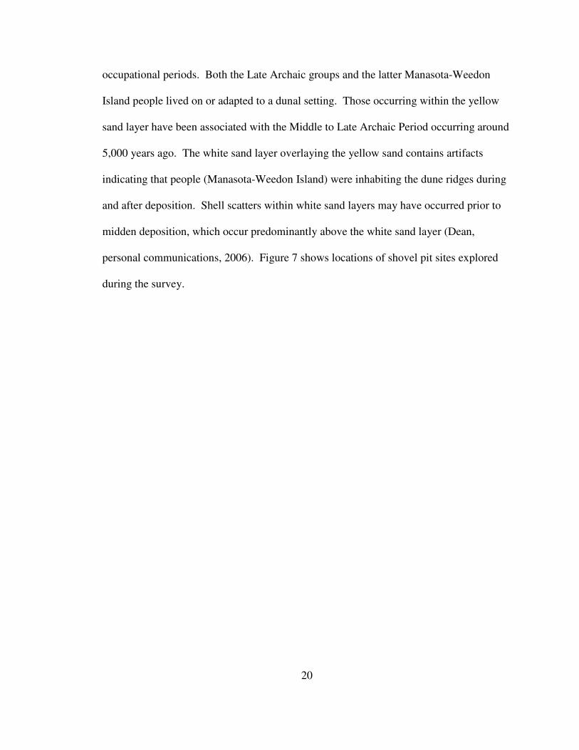
personal communications, 2006). Figure 7 shows locations of shovel pit sites explored
during the survey.
21
Fig
ure
7. Y
ello
w d
ots
repre
sent lo
cations w
here
shove
l te
sts
were
taken
duri
ng t
he a
rchae
olo
gic
al in
vestigation o
f W
eed
on
Isla
nd
. A
long w
ith
these
sh
ovel te
sts
soil
pro
bes a
nd
tra
nsects
were
als
o d
on
e in c
onju
nctio
n w
ith t
his
stu
dy. F
or
furt
her
info
rmation o
n t
he a
rchaeo
logic
al find
ings o
n W
eedo
n I
sla
nd
refe
r to
Weis
man e
t al. (
2005).
22
Methods
Field Methods
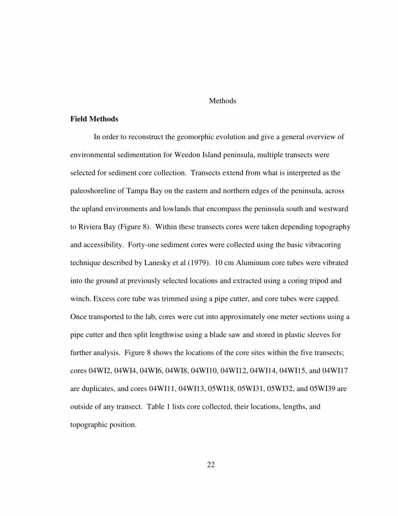
In order to reconstruct the geomorphic evolution and give a general overview of
environmental sedimentation for Weedon Island peninsula, multiple transects were
selected for sediment core collection. Transects extend from what is interpreted as the
paleoshoreline of Tampa Bay on the eastern and northern edges of the peninsula, across
the upland environments and lowlands that encompass the peninsula south and westward
to Riviera Bay (Figure 8). Within these transects cores were taken depending topography
and accessibility. Forty-one sediment cores were collected using the basic vibracoring
technique described by Lanesky et al (1979). 10 cm Aluminum core tubes were vibrated
into the ground at previously selected locations and extracted using a coring tripod and
winch. Excess core tube was trimmed using a pipe cutter, and core tubes were capped.
Once transported to the lab, cores were cut into approximately one meter sections using a
pipe cutter and then split lengthwise using a blade saw and stored in plastic sleeves for
further analysis. Figure 8 shows the locations of the core sites within the five transects;
cores 04WI2, 04WI4, 04WI6, 04WI8, 04WI10, 04WI12, 04WI14, 04WI15, and 04WI17
are duplicates, and cores 04WI11, 04WI13, 05WI18, 05WI31, 05WI32, and 05WI39 are
outside of any transect. Table 1 lists core collected, their locations, lengths, and
topographic position.
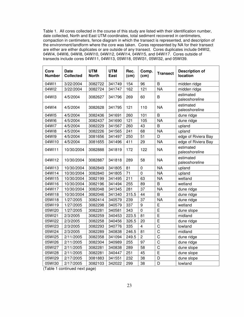
23
Table 1. All cores collected in the course of this study are listed with their identification number, date collected, North and East UTM coordinates, total sediment recovered in centimeters, compaction in centimeters, fence diagram in which the transect is represented, and description of the environment/landform where the core was taken. Cores represented by NA for their transect are either are either duplicates or are outside of any transect. Cores duplicates include 04WI2, 04WI4, 04WI6, 04WI8, 04WI10, 04WI12, 04WI14, 04WI15, and 04WI17. Cores outside of transects include cores 04WI11, 04WI13, 05WI18, 05WI31, 05WI32, and 05WI39.
Core Number
Date Collected
UTM North
UTM East
Rec. (cm)
Comp. (cm)
Transect Description of location
04WI1 3/22/2004 3082722 341749 154 96 B midden ridge
04WI2 3/22/2004 3082724 341747 162 121 NA midden ridge
04WI3 4/5/2004 3082627 341796 269 60 B estimated paleoshoreline
04WI4 4/5/2004 3082628 341795 121 110 NA estimated paleoshoreline
04WI5 4/5/2004 3082436 341691 260 101 B dune ridge
04WI6 4/5/2004 3082437 341690 121 105 NA dune ridge
04WI7 4/5/2004 3082229 341567 260 43 B upland
04WI8 4/5/2004 3082226 341565 241 68 NA upland
04WI9 4/5/2004 3081656 341497 250 51 D edge of Riviera Bay
04WI10 4/5/2004 3081655 341496 411 29 NA edge of Riviera Bay
04WI11 10/30/2004 3082888 341819 172 122 NA estimated paleoshoreline
04WI12 10/30/2004 3082887 341818 289 58 NA estimated paleoshoreline
04WI13 10/30/2004 3082849 341805 81 0 NA upland
04WI14 10/30/2004 3082840 341805 71 0 NA upland
04WI15 10/30/2004 3082199 341495 211 63 NA wetland
04WI16 10/30/2004 3082196 341494 255 89 B wetland
04WI17 10/30/2004 3082048 341345 281 37 NA dune ridge
04WI18 10/30/2004 3082046 341340 315.5 44 B dune ridge
05WI18 1/27/2005 3082414 340579 239 37 NA dune ridge
05WI19 1/27/2005 3082298 340579 337 9 E wetland
05WI20 1/27/2005 3082281 340581 343 0 E dune slope
05WI21 2/3/2005 3082259 340453 223.5 81 E midland
05WI22 2/3/2005 3082258 340456 326.5 20 E dune ridge
05WI23 2/3/2005 3082293 340776 335 4 C lowland
05WI24 2/3/2005 3082289 340838 246.5 81 C midland
05WI25 2/11/2005 3082358 341094 249.5 2 C dune ridge
05WI26 2/11/2005 3082304 340989 255 97 C dune ridge
05WI27 2/11/2005 3082281 340838 289 58 C dune slope
05WI28 2/11/2005 3082281 340447 251 45 E dune slope
05WI29 2/17/2005 3081883 341551 232 38 D dune slope
05WI30 2/17/2005 3082103 342022 299 38 D lowland
(Table 1 continued next page)
24
Table 1. (continued from p. 23)
05WI31 2/17/2005 3081791 341805 224 67 NA lowland
05WI32 2/17/2005 3081812 341691 257 24 NA lowland
05WI33 2/17/2005 3081905 341622 208 115 D wetland
05WI34 2/24/2005 3082756 341204 188 162 A midden ridge slope
05WI35 2/24/2005 3082744 341219 208 97 A midden ridge
05WI36 2/24/2005 3082685 341221 328 172 A lowland
05WI37 2/24/2005 3082734 341063 235 60 A lowland
05WI38 5/10/2005 3082184 340400 504 70 E Riviera Bay
05WI39 5/10/2005 3081533 341458 434 143 NA Riviera Bay
05WI40 5/10/2005 3082232 340773 318 69 C Riviera Bay
Lab Methods
A trowel was used to scrape excess sediment from the cores, and one half of each
core was then wrapped in plastic to serve as an undisturbed archive. All cores were
photographed prior to further analysis. Visual stratigraphic and lithologic descriptions of
sediment size, composition, structure, Munsell color, and organic content were then
constructed for all cores. Core logs are presented in Appendix A.
Three radiocarbon samples were taken from cores 04-WI-1 and 04-WI-3. A few
small pieces (few mm) of charcoal were extracted at 51cm below ground surface (BGS)
from the shelly midden layer of core 04-WI-1. Fibrous rootlets, with no obvious surface
connections, were collected [in core 04-WI-3] from a bedding plane in finely laminated,
carbonate mud at a depth of 81 cm BGS. Finally, wood fragments were collected from a
sand layer at the base of core 04-WI-3, at 268cm BGS. These were assumed to pre-date
the thick homogeneous carbonate clay bed above. The radiocarbon samples were
collected to target two events: 1) age of the midden deposits in an inland, upland core,
25
and 2) bracketing ages for the unusual carbonate mud beds within a core interpreted to be
from a nearshore paleoenvironment.
Selected core descriptions and photographs have been applied along with the
three radiocarbon age estimates to reconstruct lithologic and geomorphologic changes for
the transects. Fence diagrams were created to correlate selected cores and stratigraphic
units across the transects.
Maps and aerial photographs were also used to determine recent historical
changes that have occurred on Weedon Island. This was essential in determining an
approximate historical shoreline of the peninsula prior to the extensive mosquito ditching
activities and artificial fill associated with power plant construction on the northeast
portion of the island. These aerial photos and maps were obtained from various county
and state sources and orthorectified (if not already in the proper format). They were then
processed and analyzed using ArcGIS® software. A map of present geomorphic settings
was created for comparison with possible previous sedimentation environments.
Digital elevation models and USGS topographic maps from Pinellas County,
Florida were also employed for estimation of elevations of core sites and topographic
features in the study area. The 10 meter DEM, in Appendix B, was enhanced and
corrected in Arcscene® prior to the addition of core locations and an aerial photo overlay.
26
Results
Cores:
Photos and descriptions of each core are contained in Appendix A. Cores
representing five transects across selected landforms and environments were assembled
into fence diagrams. Figure 8 shows the locations of each core transect as well as the
cores used for each fence diagram. Table 1 lists all cores collected in the course of this
study.
27
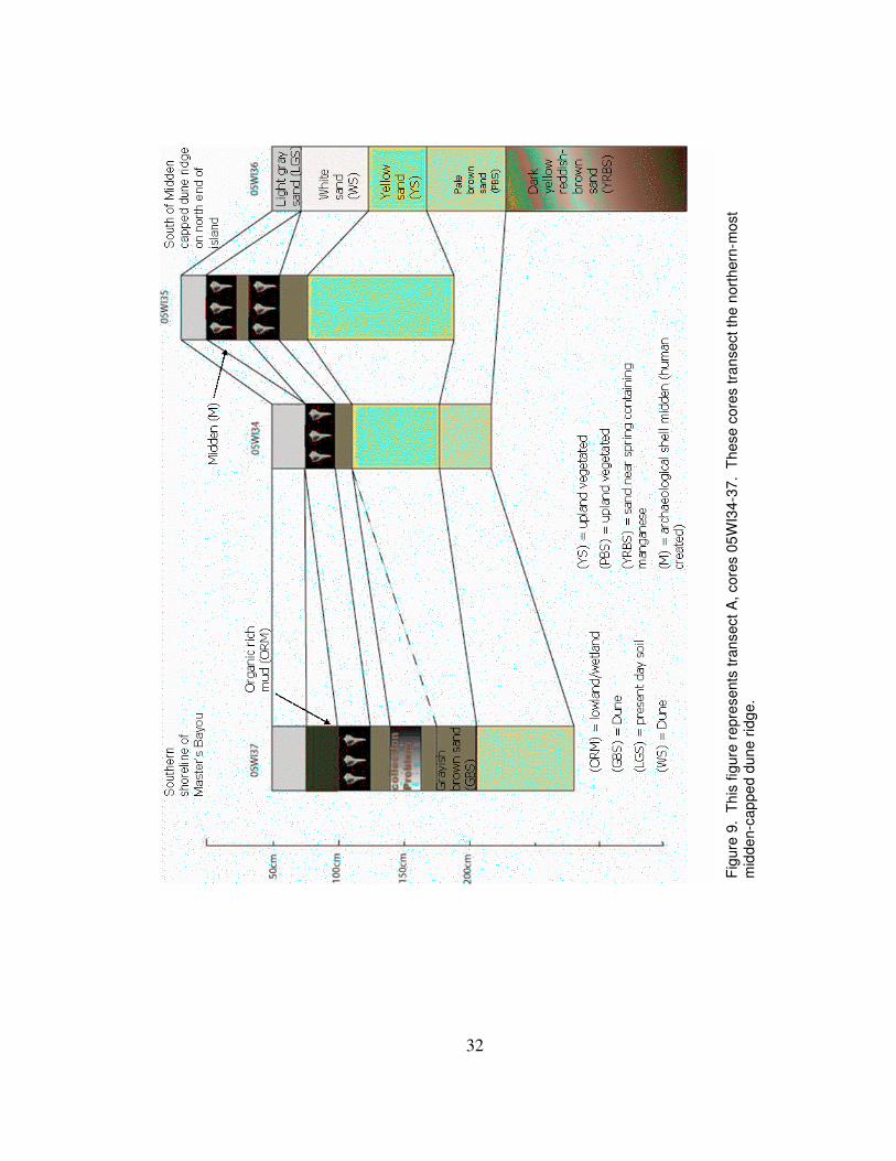
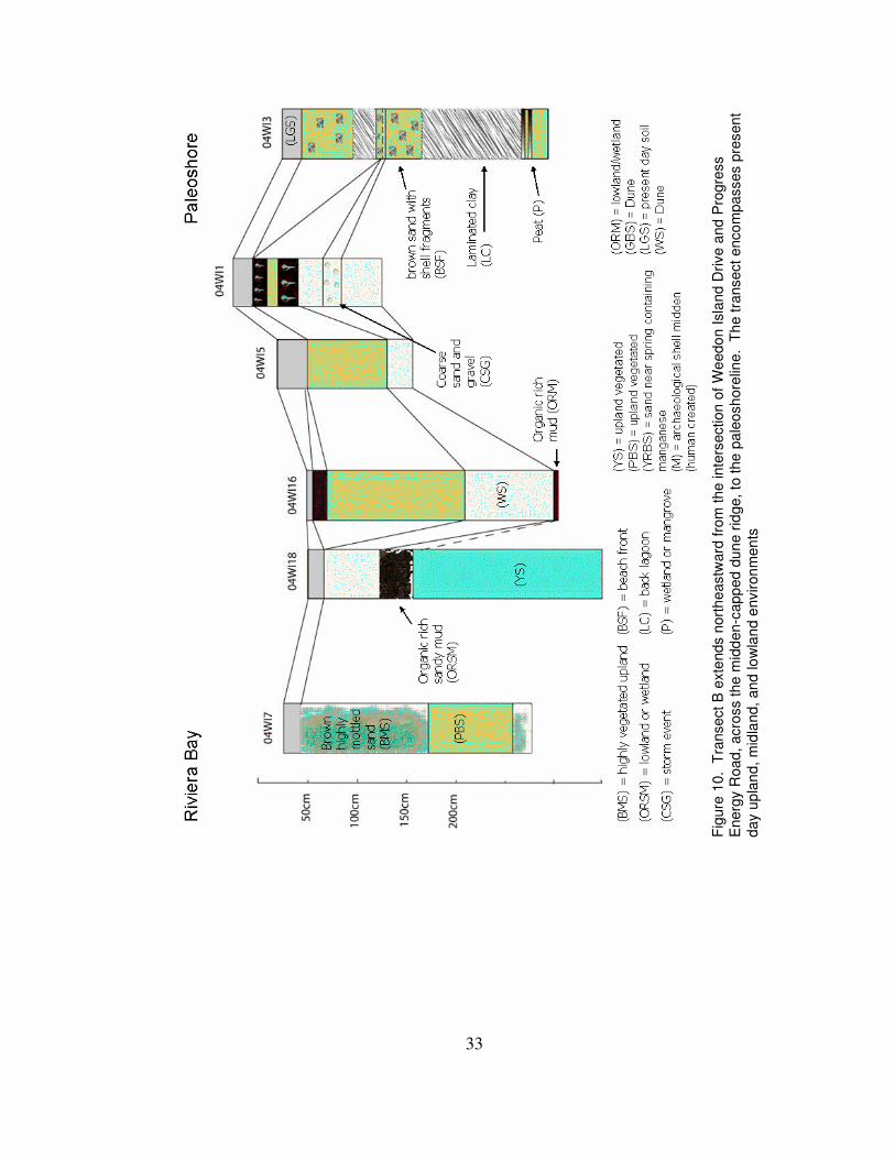
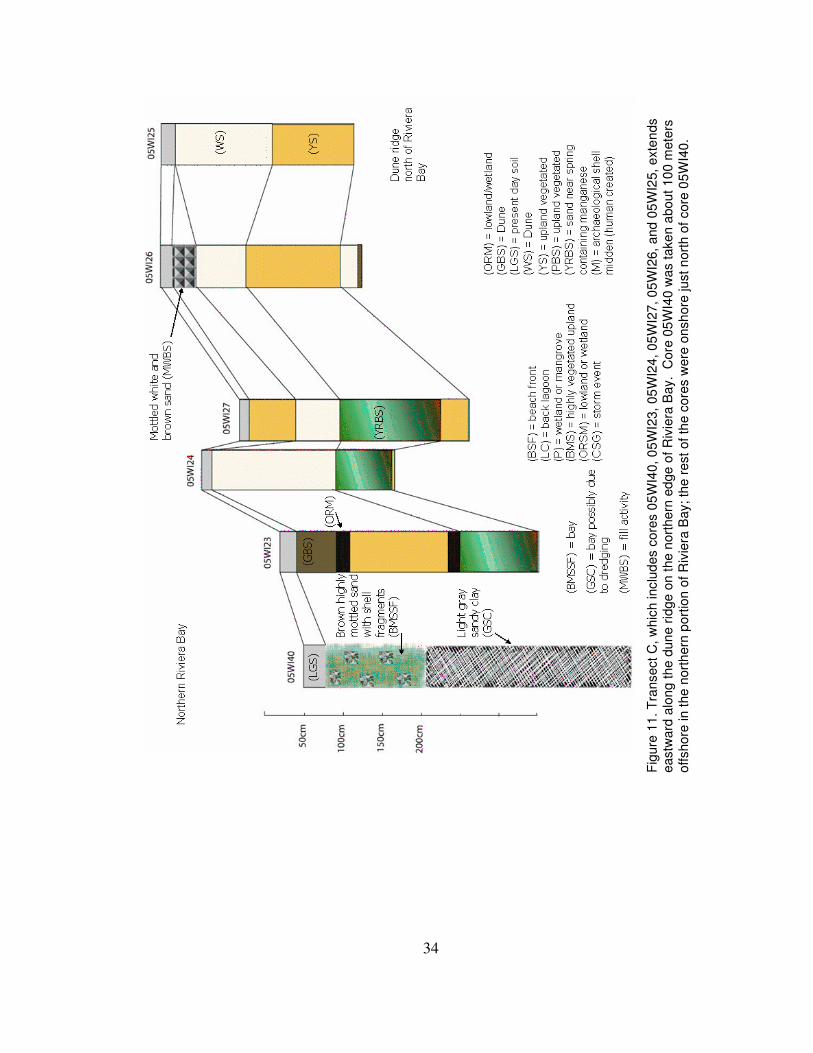
Figure 8. The red dots indicate locations where cores were taken on Weedon Island. The lettered boxes indicate groups of cores that are represented in fence diagrams A through E (Figures 9-13). Some cores were not represented within fence diagrams due to their locations or because they are duplicates of others used in the fence diagrams.
Transects were selected based on topographic position, targeted landforms,
archaeological relevance, and accessibility. Transect A extends across a midden-capped
dune ridge and is located just south of Master’s Boyou. Numerous archaeological artifact
28
sites are scattered throughout this transect area. Four cores were taken to represent
transect A. One core was taken on the top of the dune ridge, one on both the northern
and southern slopes, and one on the northern slope west of the other three locations. The
fourth core was taken to determine the distribution of midden material. Transect B
contains six cores and runs from northeast to the southwest across midden capped dune
ridges containing artifacts, low lying freshwater wetlands, to the western dunes lining
Riviera Bay. The northeastern most core (04-WI-13) in this transect is positioned on
what we have interpreted as the paleoshoreline. Transect C is situated near Old Weedon
Island drive, which lies atop a high dune ridge running along the northern edge of Riviera
Bay and is close to archaeological test sites. Transect D extends northeast to southwest
past a small lake, to the dune ridge along the eastern edge of Riviera Bay. The transect
was selected in order to try and determine the extend of the wetland, presently known as
Boy Scout Lake, in the past. Transect E begins in Riviera Bay and extends in an irregular
pattern northeast across two dune ridges. Cores were taken in Riviera Bay in order to
determine whether a freshwater-marine transition could be identified in the sediment
record (cores 37-40). Additional cores (04WI11, 04WI12, 04WI13, and 04WI140) were
collected in the Northeastern most part of the study area, in the transitional zone, between
natural sediments and construction fill, in order to further delineate the paleo-shoreline.
Sediment types were categorized and symbols for each facies were assigned.
Descriptions of each core facies are found in Table 2.
29
Table 2. List of facies identified in Weedon Island Cores. Symbols correspond to those used stratigraphic columns in figures 9-13.
Facies Name Description Symbol
Archaeological shell midden
Characteristic of a layer containing many, approximately 80%, large and small mollusk shells. Bones, charcoal, and other organic material may also be present. The boundaries are generally distinct. These layers have been identified during the archaeological reconnaissance survey as being anthropogenic created midden layers containing artifacts.
Brown sand Characteristic of a layer containing dark brown very fine grained sand with medium amount of organic content. Very similar to the very pale brown sand layer, but sand is considerably darker in color.
Brown highly mottled sand
Characteristic of a layer containing pale brown to brown highly mottled with yellow, white, and brown sand. Organic content is generally moderate to high, approximately 50% or more. The layer often appears marbled and differs from the mottled white and brown sand layer with the high organic, mostly root, content.
Brown highly mottled sand with shell fragments
Characterisitc of a layer containing pale brown to gray, highly mottled, very fine sand. Organic content consists of few to medium amounts of shell fragments.
Brown sand with shell fragments
Characteristic of a layer containing pale brown to brown highly compacted fine grained sand. Many, approximately 70%, tiny well mixed shell fragments are found within this type of layer. Boundaries are relatively distinct.
Coarse sand and gravel
Characteristic of a layer containing white to gray very fine sand with many , approximately 80% or more, solid white to very pale brown chunks. Tiny pieces of crushed shells are typically the only organic content present.
Dark yellow reddish-brown sand
Characteristic of a dark brown to yellowish brown very fine sand. Generally the layer is darker in color near the top and gradually becomes lighter. Organic material is found in small amounts, generally consisting of a few tap roots. The sand has a rusty metallic glimmer that is characteristic of sands containing maganese.
30
Grayish brown sand
Characteristic of a layer containing grayish brown very fine sand with few, about 20% or less, organic materials. This layer generally occurs below a layer with high organic content, but tends to be comprised mainly of sand itself.
Carbonate mud
Characteristic of a layer containing high, approximately 90% or more, calcium carbonate clay sized sediment. The color of the clay ranges from a white (5Y8/1) to a dark bluish gray (5PB4/1) and is often finely laminated. The boundaries are abrupt and very distinct.
Light gray sand and detritus
Characteristic of light gray, very fine grained sand containing medium to high, 30-70%, amounts of detritus material. This layer is located at the top of most cores, which corresponds well with its interpretation as top soil.
Light gray sandy clay
Characteristic of a layer containing light gray to very pale brwon sand with a medium carbonate content. The sand appears cemented when dry.
Mottled white and brown sand
Characteristic of a mottled mixture of white and light brown very fine sand, giving a marbled appearance. Organic content is moderate to few, approximately 20%, and consists of mainly roots.
Organic-rich mud Characteristic of dark brown to black organic rich layer. The sand content is low, approximately 10-20%, and there is a noticeable organic smell.
Organic-rich sandy mud
Characteristic of a layer containing grayish brown to dark brown compressed fine grained sand. Many flaky roots are present up to, about 70%, but the layer contains a higher content of fine grained sand than the 'mud' or 'peat' layers.
Peat
Characteristic of a layer containing a high percentage, approximately 70% or more, of densly compressed flakey roots. The sediment is generally dark brown with approximately 30% or less being fine grained sand.
Very pale brown sand
Characteristic of very pale brown very fine grained sand. These layers generally contain well mixed sand with some bioturbation mainly from plants. Organic material gernerally consists of a few to medium amount of tap roots.
White sand
Characteristic of a layer containing white (10YR8/1 or 10YR7/1) very fine single grained sand. The layer generally contains few, about 20% or less, organic content and is typically homogenous throughout. Organic content present usually consists of tap roots. Few to medium amount of tiny black phosphate flecks are also seen in this type of layer.
31
yellow sand Characteristic of a layer containing homogenous yellow (10YR8/6) very fine sand with few, about 20% or less, organic material. The organic content present typically consists of a few long tap roots.
Radiocarbon Dating
Radiocarbon samples were measured by University of Arizona NSF-AMS lab.
Radiocarbon age estimates were calibrated using the Cologne Radiocarbon Calibration
software, CalPal (www.calpal.de). An age estimate of 1453 ± 36 14
C yr B.P., determined
on charcoal from the 04WI1 core midden layer, is comparable to radiocarbon ages
determined on archaeological materials associated with aboriginal occupation in the area
(Weisman et al., 2005). Ages acquired for the 04WI3 core indicate that the calcium
carbonate sediment layers formed between 3369 ± 45 and 456 ± 36 14
C yr B.P. Table 3
lists radiocarbon samples measured and their calibrated results.
Table 3. Radiocarbon age estimates determined through this study. 14C ages were calibrated using the Cologne Radiocarbon Calibration software (www.calpal.de).
Sample ID Material 14C age BP Calendric Age calBP
Calendric Age calAD/BC
04-WI-1-51 charcoal 1,453±36 1350±28BP 600±28AD
04-WI-3-81 fine roots 456±36 512±15BP 1438±15AD
04-WI-3-268 wood 3369±45 3613±60BP 1663±60BC
Stratigraphic columns arranged in fence diagrams (Figures 9-13) indicate the
different facies within each core and correlations between cores across transects shown in
figure 8. Core elevations are estimates based on topographic maps and field notes. The
elevation differences are not accurate; they are generalizations to show relative
differences in topographic position within each transect. Detailed core descriptions and
photographs are compiled in Appendix A.
32
Fig
ure
9. T
his
fig
ure
repre
sents
tra
nsect
A, core
s 0
5W
I34-3
7. T
hese c
ore
s tra
nsect th
e n
ort
hern
-most
mid
den-c
ap
pe
d d
une r
idg
e.
33
Fig
ure
10.
Tra
nsect B
exte
nds n
ort
heastw
ard
fro
m the
inte
rsection o
f W
eedo
n Isla
nd D
rive a
nd P
rogre
ss
Energ
y R
oad
, acro
ss the m
idd
en-c
app
ed d
un
e r
idge,
to the
pa
leosh
ore
line. T
he t
ransect enco
mpasses p
resent
day u
pla
nd,
mid
land,
and lo
wla
nd e
nviron
men
ts
34
Fig
ure
11. T
ransect C
, w
hic
h inclu
des c
ore
s 0
5W
I40, 0
5W
I23,
05
WI2
4, 05
WI2
7,
05W
I26,
and 0
5W
I25, exte
nds
eastw
ard
alo
ng t
he d
un
e r
idge o
n t
he n
ort
hern
ed
ge o
f R
ivie
ra B
ay. C
ore
05
WI4
0 w
as take
n a
bout
10
0 m
ete
rs
offshore
in t
he n
ort
hern
port
ion
of R
ivie
ra B
ay; th
e r
est
of th
e c
ore
s w
ere
onsh
ore
just n
ort
h o
f core
05W
I40.
35
Fig
ure
12. T
he f
igure
repre
sents
Tra
nsect D
, w
ith
core
s 0
4W
I9, 0
5W
I29,
05
WI3
3,
and 0
5W
I30
. T
his
irre
gu
lar
transect
exte
nds fro
m th
e e
aste
rn s
hore
of
Riv
iera
Bay, east,
the
n s
outh
acro
ss a
dun
e r
idge,
end
ing n
ort
heast o
f B
oy S
cout L
ake.
36
Fig
ure
13. T
ransect E
conta
ins c
ore
s 0
5W
I38,
05
WI2
1, 05
WI2
2,
05
WI2
8, 05
WI1
9, an
d 0
5W
I20,
whic
h c
rosses the d
une r
idg
e
beg
inn
ing
at th
e n
ort
hw
est
end o
f R
ivie
ra B
ay. T
he c
ore
s m
ake a
nort
heaste
rly tra
nsect fr
om
core
05W
I38,
whic
h w
as taken
abou
t 10
0 m
ete
rs o
ffsh
ore
, acro
ss a
n e
ast-
west tr
end
ing d
une r
idge
to a
n u
pla
nd a
rea n
ort
h o
f W
eedo
n Isla
nd
Drive.
37
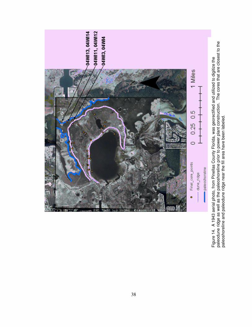
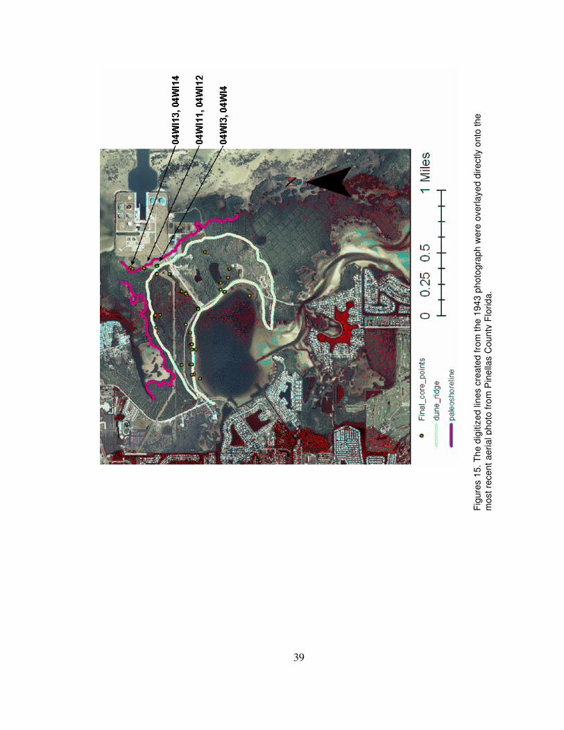
Aerial Photographs
As seen in Figures 14 and 15, the paleoshoreline and paleodune ridge can be
viewed on the rectified 1943 aerial photograph. This photo provides a geomorphic
perspective prior to large-scale alteration of the natural shoreline and topography through
the construction of the Progress Energy power plant in the northeastern part of the study
area. The locations of core sites are shown in relation to the natural shoreline position. It
is also noteable to recognize that the paleoduneridges and paleoshoreline are not the same
location. There was a low lying possibly tidal flat or marsh area in between the dunes
and the beach zone.
38
Fig
ure
14.
A 1
94
3 a
eria
l p
hoto
, fr
om
Pin
ella
s C
ou
nty
Flo
rid
a, w
as g
eore
ctified a
nd u
tiliz
ed t
o d
igitiz
e t
he
pale
od
une r
idg
e a
s w
ell
as t
he p
ale
oshore
line p
rior
to p
ow
er
pla
nt constr
uction
. T
he c
ore
s th
at are
clo
sest to
the
pale
oshore
line a
nd p
ale
od
une r
idg
e n
ear
the
fill
are
a h
ave b
een la
be
led.
39
Fig
ure
s 1
5. T
he d
igitiz
ed lin
es c
reate
d fro
m t
he 1
94
3 p
hoto
gra
ph
were
overlaye
d d
irectly o
nto
the
most re
cent
aeri
al ph
oto
fro
m P
ine
llas C
ou
nty
Flo
rid
a.
40
Discussion
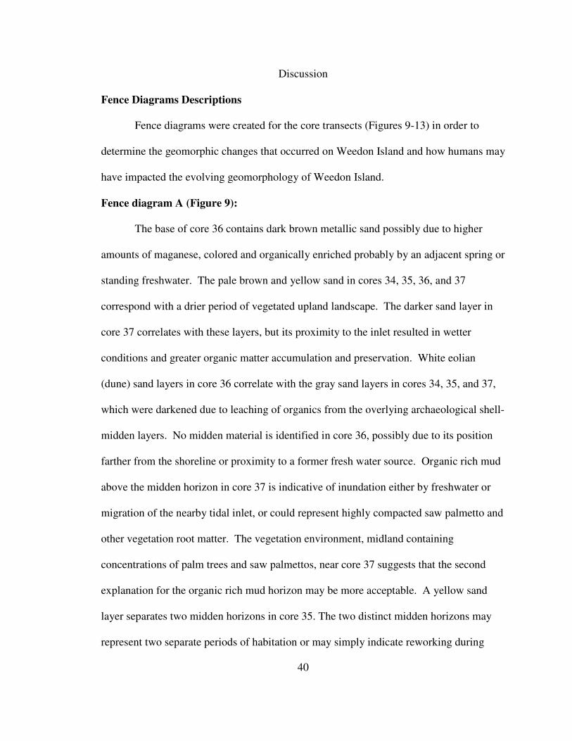
Fence Diagrams Descriptions
Fence diagrams were created for the core transects (Figures 9-13) in order to
determine the geomorphic changes that occurred on Weedon Island and how humans may
have impacted the evolving geomorphology of Weedon Island.
Fence diagram A (Figure 9):
The base of core 36 contains dark brown metallic sand possibly due to higher
amounts of maganese, colored and organically enriched probably by an adjacent spring or
standing freshwater. The pale brown and yellow sand in cores 34, 35, 36, and 37
correspond with a drier period of vegetated upland landscape. The darker sand layer in
core 37 correlates with these layers, but its proximity to the inlet resulted in wetter
conditions and greater organic matter accumulation and preservation. White eolian
(dune) sand layers in core 36 correlate with the gray sand layers in cores 34, 35, and 37,
which were darkened due to leaching of organics from the overlying archaeological shell-
midden layers. No midden material is identified in core 36, possibly due to its position
farther from the shoreline or proximity to a former fresh water source. Organic rich mud
above the midden horizon in core 37 is indicative of inundation either by freshwater or
migration of the nearby tidal inlet, or could represent highly compacted saw palmetto and
other vegetation root matter. The vegetation environment, midland containing
concentrations of palm trees and saw palmettos, near core 37 suggests that the second
explanation for the organic rich mud horizon may be more acceptable. A yellow sand
layer separates two midden horizons in core 35. The two distinct midden horizons may
represent two separate periods of habitation or may simply indicate reworking during
41
20th century human activities. Further dating of the shell material is needed in order to
confirm the possible explanations.
Fence Diagram B (Figure 10):
The base of core 3, located at the paleoshoreline, contains two separate layers of peat
formed within a moist environment, directly above a layer of pale brown sand that is
radiocarbon dated to 3,369 + 45 14
C yr B.P. The lower pale brown sand layer does not
contain shells, and most likely represents a vegetated dry land environment prior to
marine inundation. Above the peat layers in core 3 is an abrupt transition into a
homogeneous, finely laminated, carbonate clay, possibly created in a zero-energy
lacustrine or lagoonal environment by whiting events. Above the carbonate layer, highly
fragmented shelly sand, representing a beach face environment, indicates a paleo-
shoreline position. A coarse sand and gravel layer lies above the shelly sand, separated
by a sharp, horizontal boundary. We interpret the coarse layer to be a storm deposit,
which extends across the transect into core 1. Above the storm deposit in core 3, the
beach environment continues briefly, then abruptly transitions into an upper bed of finely
laminated clays. This might indicate a transition from a back lagoonal area to an open
water environment and then back to a lagoonal environment before becoming an open
water area again prior to the construction of the power plant. Organics compressed
between laminae are dated to 456 + 36 14
C yr B.P. Core 1 contains two separate
archaeological shell-midden deposits, which may correlate to the time period in which
pale brown sand accumulated in cores 16, 5, and 7. Midden material in core 1 was
deposited on dune sand, which correlates with the white eolian sand layers in the lower
42
part of core 16, 5, and upper layer of 18. Below the layers of white sand there is a layer
of organic mud or sandy organic mud in both cores 18 and 16. These organic layers
would be associated with wetland environments. The mottled facies in core 7 may either
indicate high bioturbation within the pale brown sand layer or human disturbance. When
viewing the 1943 aerial photo, it becomes apparent that core 7 is located at or near the
former location of Weedon Island Drive. The yellow sand layer in core 18 indicates a
vegetated upland or midland environment. It is likely that this layer occurs in other core
locations, but we did not penetrate to that layer. All cores in this diagram contain a light
gray layer at the top indicative of top soil.
Fence Diagram C (Figure 11):
The lower part of cores 23, 24, and 27 are dominantly dark yellow reddish-brown
metallic sand, similar to that found in core 36, which we interpret to represent a
westward migrating spring outlet adjacent to this transect. Pale brown sand in cores 25
and 26 correlates with the metallic sands in cores 23, 24, and 27. We conclude that the
pale brown sand represent the same sediment accumulation period as the metallic sand.
Organic muds in core 23 indicate an adjacent water source – possibly a spring - and
corresponding wetland environment. At that same time, a dune ridge was forming across
the sites of cores 24-27. As the spring discharge point migrated westward, away from the
site of core 23, sand accumulated in the low lying area. Core 24 does not have the light
brown sand layer identified at similar levels in cores 23 and 27, possibly due to
excavation during road construction. In the upper part of core 23, which lies closest to
Riviera Bay, is a muddy organic layer overlying the light brown sand, representing water
43
inundation and possibly mangrove expansion. The uppermost bed of light gray-brown
sand in core 23 represents eolian accumulation following a drop in water levels or fill
associated with nearby mosquito ditch excavation. The first two layers in core 26 may
also represent human disturbance due to road construction in the early nineteenth century.
The mottled white and brown sand in 26, though indicative of bioturbation, contain little
or no organic material, which supports our conclusion of human disturbance rather than
bioturbation. Core 40, taken about 100 meters from shore in the northern portion of
Riviera Bay, shows no apparent correlation with the cores taken on land. We conclude
that the cores taken from the bay may not be deep enough to determine past
environments, and the sediments may have been affected by local dredging of the Bay.
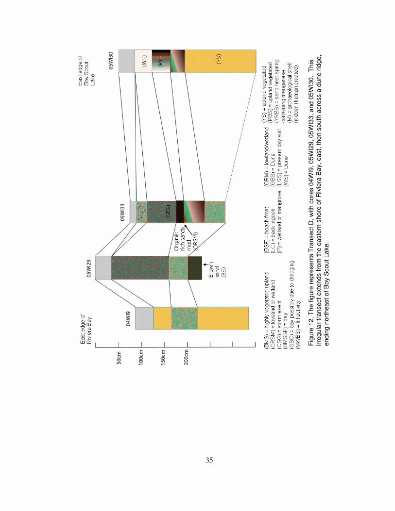
Fence Diagram D (Figure 12):
The brown highly mottled sand near the base of cores 9, 29, and 33 suggest a
period of vegetation and higher bioturbation. This probably occurred during the period of
sediment accumulation, but tap roots may have extended downwards from above layers
during the later periods as well. The grayish brown sand found in cores 29 and 33 may
have been whiter eolian sand like that found in core 30. The once white sands in core 33,
possibly more so than core 29 due to its location on the edge of Boy Scout Lake, may
have been altered due to leaching from the above layers, causing it to become a grayish
brown. The yellow sand, possibly indicating a vegetated semiarid or upland
environment, in core 9 may have accumulated during the same period as the white and
grayish brown sands in cores 29, 33, and 30. Due to its location on the opposite side of
the dune ridge, sediments accumulated at the position of core 9 may have, depending on
44
wind direction, had a different source and been more protected than the other core
locations in Transect D. A protected environment may have allowed for more vegetation
growth, which is suggested by the higher abundance of roots. The peat and organic rich
sandy mud layers, as well as the dark yellow brown layers below, found in cores 33 and
30, may indicate higher water levels in Boy Scout Lake. These higher water levels could
have enriched the soils with manganese, accounting for the metallic luster of the dark
yellow-brown sands. Higher water may have allowed more vegetation growth around the
lake’s edge, creating the peat and organic-rich sandy-mud layers. The yellow sand seen
at the bottom of cores 9 and 30 represent a vegetative environment that would have been
drier than the preceding environment that created the darker, more organic rich
sediments. All cores within diagram D contain a light gray layer at the top indicative of
top soil.
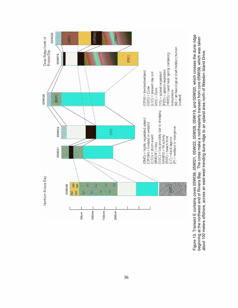
Fence Diagram E (Figure 13):
The white and grayish brown sand layers in cores 38, 22, and 20 are
interpreted as eolian dune sand, which may represent a drier period. Due to the locations
of cores 19 and 20 in a lower lying area near wetlands, more sediment may have
accumulated during that time period. The light brown sand layers in cores 28 and 21 may
have also accumulated at that time, but due to their locations on the opposite side of the
dune ridge north of Riviera Bay, there may have been more vegetation growth or less
sand accumulation. Another possible explanation for the lack of eolian whitish sand in
cores 21 and 28 is that they may have been removed during the construction of Weedon
Island Drive. Below these layers of white, grayish-brown, or pale-brown sands, there are
45
layers of organic-rich sandy mud in cores 21, 22, 19, and 20. All four cores are in
relatively lower lying areas presently adjacent to wetland areas containing mangroves and
other wetland indicator vegetation. Core 22 may have been even lower lying during this
period of accumulation than core 21. As the wetland area dried or shifted, location 22
may have been filled in with sediment before the location around core 21. A yellow sand
layer generally lies below both the white sand and organic rich mud. We interpret this
layer to be indicative of a vegetated semi-arid location. This layer may also indicate a
drier period proceeded by a wetter period which created the organic layers overlaying the
yellow sand. Cores 19 and 20 appear to have reversed layers. The dark yellow-brown
metallic sand is interpreted to have been altered through spring-water flow. The spring
outlet or pooling location may have migrated from the location of core 20 to the position
of core 19. The area around core 20 was then filled in by pale brown sediment prior to
the layers of white and grayish brown sand. Below the dark yellow-brown sand layer in
core 19, there is a pale-brown sand layer. It is unknown whether core 20 would have
penetrated into this layer, had the core been longer, or if this layer is not present at the
location of core 20. Core 38 does show some correlation with the landward cores in the
transect, but due to its location about 100 meters offshore from the northern edge of
Riviera Bay, it is unclear whether these are legitimate correlations or simply represent
recent resedimentation associated with channel dredging. If the lower layers are
undisturbed it would appear that this northern area of Riviera Bay was either once dry
land during periods of eolian sand movement, or sediment layers accumulated relatively
rapidly in a nearshore marine embayment. The layer containing sand partially cemented
with calcium carbonate suggests a dry environment where secondary CaCO3 was
46
precipitated in the shallow subsoil. Therefore, the area would have either been wet then
dry and then wet again, or it contained water the whole period, but accumulated sediment
rapidly, wind blown or erosion driven, at a fast enough pace not to be too bioturbated.
All cores accept for 38 have either light gray or brown highly mottled sand indicating a
top soil layer.
Clay Bed Interpretations
Clay sized sediment, concentrated in distinct found within cores 04WI3, 04WI4,
04WI11, and 04WI12 is almost entirely calcium carbonate, with only minor traces of
siliclastic grains. This would not have been a source for clay used in the creation of
pottery and other clay artifacts found within archaeological deposits on Weedon Island.
Possible explanations for the carbonate clay deposits include whiting events like those
described by Glenn et al. (1995). Conditions for whiting events in the past may have
been more suitable due to past climatic changes including wetter and possibly warmer
more tropical conditions as seen in the Soto (2005) and Lake Tulane (Cross et al., 2004;
Grimm et al., 1993) studies.
Another possible explanation is that the area where the carbonate clays formed
and accumulated was formerly seaward of the paleoshoreline within a back-barrier
microtidal carbonate lagoonal environment, as described by Nichols (1999). Figure 14
illustrates the location of cores compared with the shoreline prior to power plant
construction in the area, which indicates the possibility of a lagoonal paleoenvironment.
That type of environment would have been associated with hypersaline, calm conditions
deterring bioturbation and restricting coarse siliciclastic inputs. The barrier islands in
47
that scenario, examples of which are present offshore of Weedon Island today, may have
originated as oyster bars with mangroves colonizing the banks. Mangroves’ associated
fauna are known to create calcium carbonate waste that could be oxidized creating the
light gray color (Brinkman, personal communication, 2006). These back barrier
conditions could have also been ideal environments for whitings to occur. The
laminations within the carbonate clays are more suggestive of repeated whiting events,
rather than semi-continuous sedimentation that would be expected under the mangrove
model.
It is likely that the paleoenvironments adjacent to Weedon Island were formerly
analogous to that described by Donahue and others (2003). According to Donahue’s
model, the marine inundation of Tampa Bay began around 5,000 yr B.P., and a shallow
protected estuarine environment replaced what was previously once a freshwater
depression. Our cores along the paleoshoreline may preserve a record of the initial
encroachment of rising sea-level to a position just high enough to inundate the region of
Tampa Bay where Weedon Island is situated. Prior to the creation of the carbonate clay
layers peat layers indicate a wetland environment, although the absence of fossils
precludes a freshwater vs. marine interpretation. Radiocarbon ages for the basal sand
layer, around 3,600 14
C yr B.P. fall at the end of a period of higher rate of sea-level rise,
according to Donahue and others (2003). Donahue et al. (2003) and Wanless (1994)
interpret a reduction of the rate of sea-level rise around 3,000 yr B.P., although sea-level
has gradually continued to rise since that time. Wright and others (2005) interpreted a
slightly lower rate of rise during that period, but all agree that sometime between about
3,000 and 2,500 yr B.P., the rate of sea-level rise decreased considerably compared with
48
the period prior to 5,000 yr B.P.. This slowing in sea level rise allows for mangrove and
oyster beds to colonize surfaces and keep up with the rate of vertical aggradation,
resulting in the formation of sand bars and islands in the newly indundated tidal regions.
We interpret the 3,600 14
C yr B.P. paleoshoreline of Weedon Island to have been
approaching a similar position to that observed in the 1943 aerial image (Figure 14).
While it would have been approximately 0-2m meters below present, it would have
reached the inner Tampa Bay region. Coastal environments would have been stabilizing,
allowing for more long-term human occupation of the coastal zone. These environments
allowed for human occupation of the area as the sea level continued to slowly rise and the
climate shifted from wetter to drier conditions.
Comparison With Paleoclimate Records
Radiocarbon age estimates on samples taken from the cores appear to match well
with both archaeological and paleoclimatic data. Charcoal dated 1453 ± 36 14
C yr B.P.,
collected from midden sediments within core 04WI1, corresponds well with
archaeological findings previously reported in the region and recently identified through
archaeological reconnaissance on Weedon Island (Weisman et al., 2005).
My interpretations suggest a correlation between three radiocarbon-dated
sedimentary horizons with wetter and drier periods identified in the speleothem
paleoclimate record of Soto (2005). Figure 16 shows the calibrated ages determined in
my study compared with Soto (2005) speleothem data and interpreted Little Salt Springs
(Alvarez et al., 2005) data compiled and graphed by Van Beynen (2006).
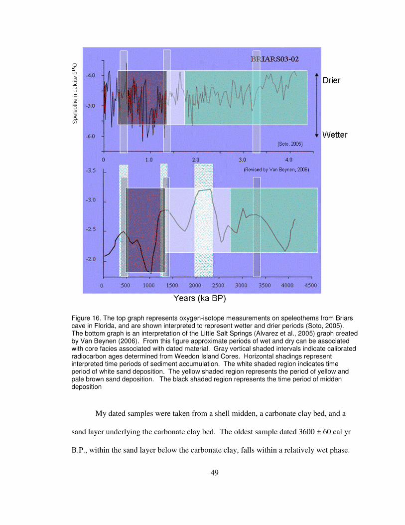
49
Figure 16. The top graph represents oxygen-isotope measurements on speleothems from Briars cave in Florida, and are shown interpreted to represent wetter and drier periods (Soto, 2005). The bottom graph is an interpretation of the Little Salt Springs (Alvarez et al., 2005) graph created by Van Beynen (2006). From this figure approximate periods of wet and dry can be associated with core facies associated with dated material. Gray vertical shaded intervals indicate calibrated radiocarbon ages determined from Weedon Island Cores. Horizontal shadings represent interpreted time periods of sediment accumulation. The white shaded region indicates time period of white sand deposition. The yellow shaded region represents the period of yellow and pale brown sand deposition. The black shaded region represents the time period of midden deposition
My dated samples were taken from a shell midden, a carbonate clay bed, and a
sand layer underlying the carbonate clay bed. The oldest sample dated 3600 ± 60 cal yr
B.P., within the sand layer below the carbonate clay, falls within a relatively wet phase.
50
According to our ages, the carbonate formed between 3600 ± 60 and 510 ± 15 cal yr.
B.P., which correspond to a relatively long wet period. An age of 1350 ± 30 cal yr B.P.
determined on charcoal within the midden layer, corresponds with the end of a wet period
that preceded a much drier period. Below all of the midden layers and within many of
the other cores a layer of white eolian sand was found with very little organic material.
This facies may correlate with the drier period around 1.3 ka BP.
The climate was drier during the period from about 1.75 to 1.3 ka B.P., with a
sharp increase in precipitation around 0.9 ka BP, which may correlate with shell midden
construction and human occupation. In cores 04WI1 and 05WI35 I identified potentially
two distinct occupation horizons, represented by separate midden beds. With so few
radiocarbon dated samples, it is difficult to interpret specific time periods of occupation.
It is also possible that the double midden beds represent erosion and downslope
redeposition, which could be revealed through additional radiocarbon dating. With the
dates I have one possible explanation, if there are multiple events, which is that the layer
of white sand occurring between the midden layers accumulated during the drier period
around 1.75ka BP. A possible explanation for leaving the area at that time might be the
lack of fresh water if the drier climate caused the fresh springs in the area to become less
active.
Other facies within the cores also correlate with the speleothem data. Below the
white sand layers within all of the cores, layers of either yellow sand or organic-rich
sand/peat are observed. These facies are interpreted as forming under vegetation cover.
According to the speleothem data, there was a drier period that I associated with the
white sand facies. Without further age control, however, these are only speculations.
51
The cores along the paleoshoreline show no obvious indications that sea level was
higher than present during the period studied, as suggested by Stapor et al. (1991).
Instead, there appears to be evidence of a continual rise in sea level, as indicated by
Wright et al. (2005). The sediment at the bottom of the paleoshore cores (04WI3)
reflects a vegetated dryland environment much like the facies seen in other more upland
cores. Separate layers of peat and intermixed sand, which may be interpreted as
ephemeral wetlands or could be indicative of mangrove transgression and regression seen
in the Ten Thousand Island area of Florida as the rate of sea level rise has fluctuated
(Donahue et al., 2003). Finely laminated clay layers occur directly above these peat
layers indicating a possible transition from a shallow shoreline environment to a slightly
deeper back lagoonal environment. Sand with intermixed broken shells in the preceding
layer, as well as gravel layers indicating a possible storm event, show a transition to a
beach environment. That type of environment persisted until the construction of the
power plant, and can be viewed in the 1943 aerial photo (Figure 14).
52
Conclusion
There appears to be some correlation within our cores and dates taken from our
samples to the time periods found in both the paleoclimate as well as the archaeological
records of the area. Sand layers below the midden layers indicate a drier phase in the
climate and suggest that the ancient humans settled on existing dune structures in a region
containing freshwater springs and an estuarine food source. According to Weisman et al.
(2005), ancient humans occupied the area to some extent prior to deposition of the white
eolian sand layers. The shell middens, which overlie the white sand, would have been
created at the end of, or following formation of these dune ridges. We infer that the
indigenous peoples created the middens after sea-level had reached near present
elevation. The environment at the time would be that of an estuary ideal for oyster bed
creation and other mollusk inhabitation, enabling the creation of shell middens. We did
not find evidence of a higher than present sea level, but one that has continued to rise at
varying rates.
In review of my hypothesis I asked three research questions. After analysis and
further interpretation of my data I have made the following conclusions.
� How did changes in sea level affect the geomorphology and sedimentation
processes of Weedon Island?
– The paleoshoreline cores show a transition from vegetated soils to wetland
environments, to marine environments.
53
� What is the relationship between human manipulation of the landscape and the
natural sedimentation processes in the geomorphic evolution?
– Humans appear to have settled on existing dune ridges and modified and
enhanced the topography through the creation of midden piles.
� What additional research will be required to assess the anthropogenic and
paleoclimate affects on the island’s geomorphology?
– Future research is needed to understand the timing of formation of the
natural and anthropogenic features on Weedon Island. Considerably more
radiocarbon dating would assist in the effort to correlate facies across core
transects, toward the ultimate goal of reconstructing relationships between
sea-level rise, coastal geomorphology, paleoclimatology, and the
archaeological record.
54
References
Anonymous1984, Environments of South Florida, present and past; II: United States
(USA), Miami Geological Society, Coral Gables, FL, United States (USA), .
Alvarez Zarikian, C.A., Swart, P.K., Gifford, J.A., and Blackwelder, P.L., 2005,
Holocene paleohydrology of Little Salt Spring, Florida, based on ostracod assemblages
and stable isotopes; Earth environments and dynamics of Ostracoda; selected papers from
the symposium "Towards the new ostracodology in the 21st century": Palaeogeography,
Palaeoclimatology, Palaeoecology, v. 225, p. 134-156, doi:
10.1016/j.palaeo.2004.01.023.
Balsillie, J.H., and Donoghue, J.F., 2004, High resolution sea-level history for the Gulf of
Mexico since the last glacial maximum: Report 103, 65 p.
Beck B.F., 1984, Sinkholes; their geology, engineering and environmental impact:
Netherlands (NLD), A. A. Balkema, Rotterdam, Netherlands (NLD).
Blum, M.D., Misner, T.J., Collins, E.S., Scott, D.B., Morton, R.A., and Aslan, A., 2001,
Middle Holocene sea-level rise and highstand at 12 m, central Texas coast: Journal of
Sedimentary Research, v. 71, p. 581-588.
Brinkman, R. 2006, verbal communication: Carbonate Mud Conversation.
Brooks, G.R., Doyle, L.J., Davis, R.A.,Jr, DeWitt, N.T., and Suthard, B.C., 2003,
Patterns and controls of surface sediment distribution; west-central Florida inner shelf;
Neogene geology of a linked coastal/inner shelf system; west-central Florida: Marine
Geology, v. 200, p. 307-324, doi: 10.1016/S0025-3227(03)00189-0.
Cane, M.A., 2005, The evolution of El Nino, past and future: Earth and Planetary Science
Letters, v. 230, p. 227-240, doi: 10.1016/j.epsl.2004.12.003.
Cross, E., Hollander, D.J., Huang, Y., and Van Vleet, E., 2003, Compound specific D/H
analysis of late Holocene lacustrine sediments in sub-tropical North America;
implications for reconstructing atmospheric circulation patterns and hydrologic
55
conditions; Geological Society of America, 2003 annual meeting: Abstracts with
Programs - Geological Society of America, v. 35, p. 61.
Curtis, J.H., and Hodell, D.A., 1993, An isotopic and trace element study of ostracods
from Lake Miragoane, Haiti; a 10,500 year record of paleosalinity and paleotemperature
changes in the Caribbean; Climate change in continental isotopic records: Geophysical
Monograph, v. 78, p. 135-152.
Davis, R.A.,Jr, Cuffe, C.K., Kowalski, K.A., and Shock, E.J., 2003, Stratigraphic models
for microtidal tidal deltas; examples from the Florida Gulf Coast; Neogene geology of a
linked coastal/inner shelf system; west-central Florida: Marine Geology, v. 200, p. 49-60,
doi: 10.1016/S0025-3227(03)00164-6.
Davis, R.A.,Jr, Yale, K.E., Pekala, J.M., and Hamilton, M.V., 2003, Barrier island
stratigraphy and Holocene history of west-central Florida; Neogene geology of a linked
coastal/inner shelf system; west-central Florida: Marine Geology, v. 200, p. 103-123, doi:
10.1016/S0025-3227(03)00179-8.
Dean, J., 2006, verbal communication: Archaeological Conversation.
Donahue B.T, Twichell D.C, Hine A.C, Tebbens S, and Locker S.D, 2003, Late
Holocene estuarine-inner shelf interactions; is there evidence of an estuarine retreat path
for Tampa Bay, Florida? Marine Geology, v. 200, p. 219-241.
Dorsey, R.A., 1997, Predicted Sea Level Changes, Florida Gulf Coast Over the Past
21,000 years: Gulf Archaeology Research Institute, Report 9, 1-1-25 p.
Duncan, D.S., Locker, S.D., Brooks, G.R., Hine, A.C., and Doyle, L.J., 2003, Mixed
carbonate-siliciclastic infilling of a Neogene carbonate shelf-valley system; Tampa Bay,
west-central Florida; Neogene geology of a linked coastal/inner shelf system; west-
central Florida: Marine Geology, v. 200, p. 125-156, doi: 10.1016/S0025-
3227(03)00180-4.
Fairbridge, R.W., 1974, The Holocene sea-level record in South Florida: Memoir -
Miami Geological Society, no.2, Environments of South Florida; Present and Past, p.
223-232.
Felzer, B., Webb, T.,III, and Oglesby, R.J., 1998, The impact of ice sheets, CO (sub 2) ,
and orbital insolation on later Quaternary climates; sensitivity experiments with a general
56
circulation model; Late Quaternary climates; data synthesis and model experiments:
Quaternary Science Reviews, v. 17, p. 507-534.
Fewkes, J.W., 1924, Preliminary Archaeological Investigations at Weedon Island,
Florida: Smithsonian Institution, Report 76 (13), 1-1-26 p.
Glenn, C.R., Rajan, S., McMurtry, G.M., and Benaman, J., 1995, Geochemistry,
mineralogy, and stable isotopic results from Ala Wai estuarine sediments; records of
hypereutrophication and abiotic whitings; Scientific studies of the Ala Wai Canal, an
artificial tropical estuary in Honolulu, Hawaii: Pacific Science, v. 49, p. 367-399.
Grimm, E.C., Jacobson, G.L.,Jr, Watts, W.A., Hansen, B.C.S., and Maasch, K.A., 1993,
A 50,000-year record of climate oscillations from Florida and its temporal correlation
with the Heinrich events: Science, v. 261, p. 198-200.
Hebert, J.A., 1985, High-resolution seismic stratigraphy of the inner western Florida shelf
west of Tampa Bay; evidence for a Miocene karst valley system [Ph.D. thesis]: United
States (USA), University of South Florida, St. Petersburg, St. Petersburg, FL, United
States (USA), .
Hine, A.C., 1997, Structural and paleoceanographic evolution of the margins of the
Florida Platform, in Randazzo, A.F. and Jones, D.S., eds., The geology of Florida: United
States (USA), University Press of Florida, Gainesville, FL, United States (USA), .
Lanesky, D.E., Logan, B.W., Brown, R.G., and Hine, A.C., 1979, A new approach to
portable vibracoring underwater and on land: Journal of Sedimentary Petrology, v. 49, p.
654-657.
Milanich, J.T., 2002, Weedon Island Cultures: Tuscaloosa, AL, Alabama Press, p. 198-1-
198.
Morton, R.A., Paine, J.G., and Blum, M.D., 2000, Responses of stable bay-margin and
barrier-island systems to Holocene sea-level highstands, western Gulf of Mexico: Journal
of Sedimentary Research, v. 70, p. 478-490.
Nichols, G., 1999, Sedimentology and Stratigraphy: Oxford, England, Blackwell Science,
p. 355-1-355.
Otvos, E.G., 2005, Holocene aridity and storm phases, Gulf and Atlantic Coasts, USA:
Quaternary Research, v. 63, p. 368-373, doi: 10.1016/j.yqres.2005.02.002.
57
Poore, R.Z., Dowsett, H.J., Verardo, S., and Quinn, T.M., 2003, Millennial- to century-
scale variability in Gulf of Mexico Holocene climate records: Paleoceanography, v. 18, p.
13, doi: 10.1029/2002PA000868.
Robbin, D.M., 1984, A new Holocene sea level curve for the upper Keys and Florida
Reef tract, in Gleason, P.J., ed., Environments of South Florida, present and past; II:
United States (USA), Miami Geological Society, Coral Gables, FL, United States (USA),
.
Schmidt, W., 1997, Geomorphology and physiography of Florida, in Randazzo, A.F. and
Jones, D.S., eds., The geology of Florida: United States (USA), University Press of
Florida, Gainesville, FL, United States (USA), .
Scott, T.M., 1997, Miocene to Holocene history of Florida, in Randazzo, A.F. and Jones,
D.S., eds., The geology of Florida: United States (USA), University Press of Florida,
Gainesville, FL, United States (USA), .
Smith, D.L., and Lord, K.M., 1997, Tectonic evolution and geophysics of the Florida
basement, in Randazzo, A.F. and Jones, D.S., eds., The geology of Florida: United States
(USA), University Press of Florida, Gainesville, FL, United States (USA), .
Soto, L., 2005, Reconstruction of Late Holocene Precipitation for Central Florida as
Derived from Isotopes in Speleothems [Ph.D. thesis]: Tampa, FL, University of South
Florida, p. 1-1-90.
Stahl, L.E., 1969, The marine geology of Tampa bay (Florida) [Ph.D. thesis]: United
States (USA), Florida State University, Tallahassee, FL, United States (USA), .
Stahle, D.W., and Cleaveland, M. K., Reconstruction and analysis of spring rainfall over
the Southeastern U.S. for the past 1000 years: Bulliten of the American Meteorological
Society, v. 73, p. 1947-1961.
Stapor, F.W.,Jr, Mathews, T.D., and Lindfors-Kearns, F.E., 1991, Barrier-island
progradation and Holocene sea-level history in Southwest Florida: Journal of Coastal
Research, v. 7, p. 815-838.
Van Beynen, P., 2006, verbal communication: Paleoclimate Conversation.
Wanless, H.R., Tedesco, L.P., Cottrell, D., Tagett, M.G., Prospero, J.M.(., and Harwell,
C.C.(., 1994, Holocene environmental history of carbonate banks in Florida Bay and
58
Biscayne Bay, south Florida; Symposium on Florida Keys regional ecosystem: Bulletin
of Marine Science, v. 54, p. 1087.
Watts, W.A., and Stuiver, M., 1980, Late Wisconsin climate of northern Florida and the
origin of species-rich deciduous forest: Science, v. 210, p. 325-327.
Weisman, B.R., Dean, J., O'Brien, M., and Collins, L.D., 2005, Comprehensive Cultural
Resource Survey of the Weedon Island Preserve, Pinellas County, Florida: University of
South Florida, Report 1, 1-1-401 p.
Willey, G.R., 1949, Archaeology of the Florida Gulf Coast: Gainesville, FL, USA,
University Press of Florida, p. 100-1-100.
Wright, E.E., Hine, A.C., Goodbred, S.L.,Jr, and Locker, S.D., 2005, The effect of sea-
level and climate change on the development of a mixed siliciclastic-carbonate, deltaic
coastline; Suwannee River, Florida, U.S.A: Journal of Sedimentary Research, v. 75, p.
621-635, doi: 10.2110/jsr.2005.051.
59
Appendix A
Core digital Library
60
Site Name: Weedon Island Core length: 154cm Core Sections:2__
Core I.D.: 04WI1 Number of Layers: 7 Compaction: 115cm
Date Taken: 3/22/04 UTM Location: UTM-17-0341749E 3082722N
I. 0-20 10YR6/3 pale brown very fine single grained
sand, medium to many detritus material,
abrupt boundary.
II. 20-33cm 10YR6/3 pale brown very fine sand w/
very high whole shell and crushed shell
content, about 70%, a bone and large root lay
vertically near bottom of layer, abrupt
boundary.
III. 33-45cm 10YR8/6 yellow sand pretty
homogenous layer, some darker flecks and
mottles, very few shell frags, little to no
organics, abrupt boundary.
IV. 45-63cm 10YR5/1 gray very fine sand, 90%
whole and crushed shells, high organic
content in sand, abrupt boundary.
V. 63-87cm 10YR7/1 light gray clor gradually gets
lighter to a 10YR8/1 white very fine single
grained sand abrupt boundary.
VI. 87-110cm 10YR8/1 white sand w/ horizontal
layers of solid 10YR8/2 very pale brown
chunks, possibly reworked limestone or
nodules, 3 main horizontal lines of chunks w/
smaller pieces throughout, abrupt boundary.
VII. 110-150cm 10YR8/1 white very fine single
grainedsand gradually turning 10YR8/2 very
pale brown, homogenous layer, no organics.
61
Site Name: Weedon Island Core length: 162cm Core Sections:2__
Core I.D.: 04WI2 Number of Layers: 5 Compaction: 135cm
Date Taken: 3/22/04 UTM Location: UTM-17-0341749E 3082722N
I. 0-5cm 10YR2/2 very dark brown high organic
detritus content, many tiny roots, distinct
boundary.
II. 5-27cm 10YR4/1 dark gray very fine single
grained sand, well mixed medium amount of
broken shells and fragments, about 40%,
abrupt boundary.
III. 27-62cm 10YR4/1 dark gray very fine sand very
high large and broken/fragmented shells,
highly compacted 90% shells, abrupt
boundary.
IV. 62-115cm 10YR8/1 white very fine single
grained sand, light gray at top gradually
getting lighter, few 10YR7/1 white light
brown chunks of either reworked limstone or
nodules mixed throughout layer, not in
distinct layers, semi-distinct boundary.
V. 115-162cm 10YR7/1 very pale brown very fine
single grained sand, highly mottled at top of
layer w/ 10YR6/3 pale brown sand, few
mottles continue throughout layer, tiny
organic fragments (possibly roots) at top of
layer.
62
Site Name: Weedon Island Core length: 269cm Core Sections:3__
Core I.D.: 04WI3 Number of Layers: 11 Compaction: 100cm
Date Taken: 4/5/04 UTM Location: UTM-17-0341796E 3082627N
I. 0-20cm 10YR7/2 light gray very fine single
grained sand, well mixed w/ tiny
detritus frags, semi-abrupt boundary.
II. 20-72cm 10YR8/2 very pale brown very
fine sand, very compacted, circular
chunk of clay at 55cm, well mixed tiny
shell frags thoughout layer, pretty
homogenous, very distinct boundary.
III. 72-90cm 5Y8/1 white clay w/ highly
laminated layers of 5PB4/1 dark bluish
gray and 2.5Y5/4 light olive brown,
mainly finely laminated layers of white
and bluish clay, very distinct boundary.
IV. 90-100cm 10YR8/2 very pale brown very
fine sand very well mixed w/ tiny shell
frags, abrupt boundary.
V. 100-104cm 10YR8/2 very pale brown sand,
mainly 90% chunks, possibly reworked
limestone or nodules, few shell frags
intermixed, abrupt boundary.
VI. 104-140cm 10YR8/2 very pale brown
highly compacted single grained sand,
many tiny well mixed shell frags
throughout layer, less at bottom of layer,
very distinct boundary.
VII. 140-240cm 5Y8/1 white clay highly
laminated at top of layer w/ 5PB4/1 dark
bluish green clay, from 165-200cm pure
white clay w/ very few bluish streaks,
from 200-240 highly laminated w/ blue
and 5Y7/2 light gray streaks.
VIII. 240-245cm 10YR2/1 black highly
compacted muddy peat, very distinct
boundary.
IX. 245-249cm 10YR7/2 light gray very fine
single grained sand, no shell frags,
homogenous sand, distinct boundary.
X. 249-253cm 10YR2/2 very dark brown
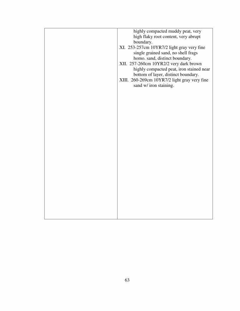
63
highly compacted muddy peat, very
high flaky root content, very abrupt
boundary.
XI. 253-257cm 10YR7/2 light gray very fine
single grained sand, no shell frags
homo. sand, distinct boundary.
XII. 257-260cm 10YR2/2 very dark brown
highly compacted peat, iron stained near
bottom of layer, distinct boundary.
XIII. 260-269cm 10YR7/2 light gray very fine
sand w/ iron staining.
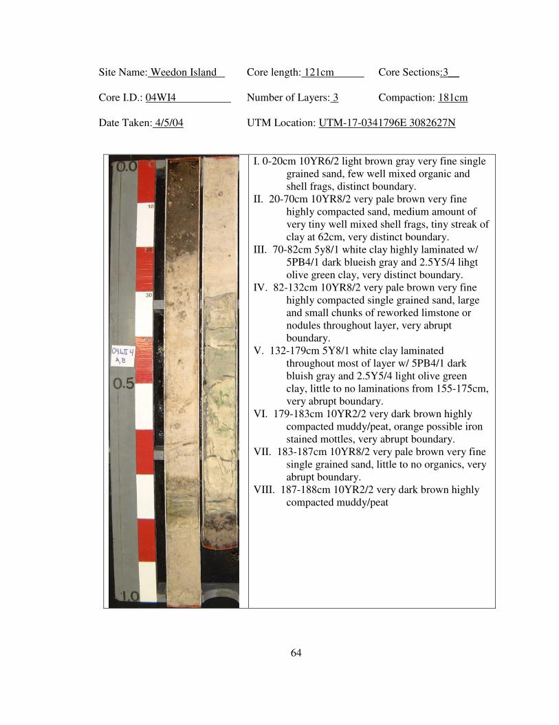
64
Site Name: Weedon Island Core length: 121cm Core Sections:3__
Core I.D.: 04WI4 Number of Layers: 3 Compaction: 181cm
Date Taken: 4/5/04 UTM Location: UTM-17-0341796E 3082627N
I. 0-20cm 10YR6/2 light brown gray very fine single
grained sand, few well mixed organic and
shell frags, distinct boundary.
II. 20-70cm 10YR8/2 very pale brown very fine
highly compacted sand, medium amount of
very tiny well mixed shell frags, tiny streak of
clay at 62cm, very distinct boundary.
III. 70-82cm 5y8/1 white clay highly laminated w/
5PB4/1 dark blueish gray and 2.5Y5/4 lihgt
olive green clay, very distinct boundary.
IV. 82-132cm 10YR8/2 very pale brown very fine
highly compacted single grained sand, large
and small chunks of reworked limstone or
nodules throughout layer, very abrupt
boundary.
V. 132-179cm 5Y8/1 white clay laminated
throughout most of layer w/ 5PB4/1 dark
bluish gray and 2.5Y5/4 light olive green
clay, little to no laminations from 155-175cm,
very abrupt boundary.
VI. 179-183cm 10YR2/2 very dark brown highly
compacted muddy/peat, orange possible iron
stained mottles, very abrupt boundary.
VII. 183-187cm 10YR8/2 very pale brown very fine
single grained sand, little to no organics, very
abrupt boundary.
VIII. 187-188cm 10YR2/2 very dark brown highly
compacted muddy/peat

65
Site Name: Weedon Island Core length: 260cm Core Sections:2__
Core I.D.: 04WI5 Number of Layers: 4 Compaction: 152cm
Date Taken: 4/5/04 UTM Location: UTM-17-0341690E 3082437N
I. 0-35cm 10YR6/1 gray very fine single
grained sand, high content of detritus
at top of layer, well mixed leaf litter
and organic matter, gets less towards
bottom of layer, gradual boundary.
II. 35-112cm 10YR7/4 very pale brown very
fine single grained sand, medium
sized roots/sticks at top of layer,
smaller roots at 60-80cm, organic
matter decreases throughout layer 80-
112cm pure sand, gradual boundary.
III. 112-140cm 10YR8/1 white very fine
single grained sand, pure sand w/
medium amount of tiny black
phosphate flecks, higher content of
flecks from 115-125cm.
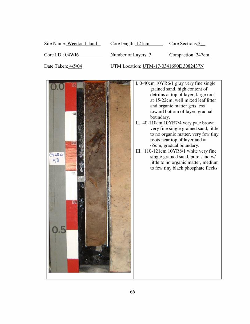
66
Site Name: Weedon Island Core length: 121cm Core Sections:3__
Core I.D.: 04WI6 Number of Layers: 3 Compaction: 247cm
Date Taken: 4/5/04 UTM Location: UTM-17-0341690E 3082437N
I. 0-40cm 10YR6/1 gray very fine single
grained sand, high content of
detritus at top of layer, large root
at 15-22cm, well mixed leaf litter
and organic matter gets less
toward bottom of layer, gradual
boundary.
II. 40-110cm 10YR7/4 very pale brown
very fine single grained sand, little
to no organic matter, very few tiny
roots near top of layer and at
65cm, gradual boundary.
III. 110-121cm 10YR8/1 white very fine
single grained sand, pure sand w/
little to no organic matter, medium
to few tiny black phosphate flecks.
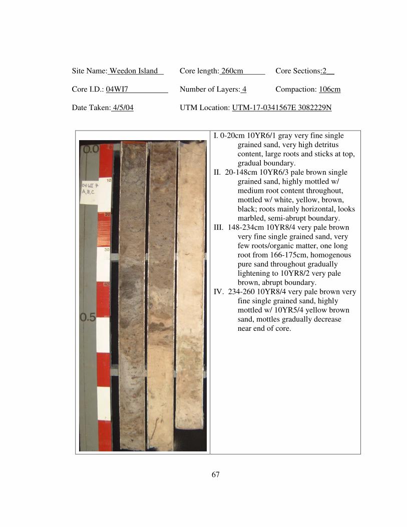
67
Site Name: Weedon Island Core length: 260cm Core Sections:2__
Core I.D.: 04WI7 Number of Layers: 4 Compaction: 106cm
Date Taken: 4/5/04 UTM Location: UTM-17-0341567E 3082229N
I. 0-20cm 10YR6/1 gray very fine single
grained sand, very high detritus
content, large roots and sticks at top,
gradual boundary.
II. 20-148cm 10YR6/3 pale brown single
grained sand, highly mottled w/
medium root content throughout,
mottled w/ white, yellow, brown,
black; roots mainly horizontal, looks
marbled, semi-abrupt boundary.
III. 148-234cm 10YR8/4 very pale brown
very fine single grained sand, very
few roots/organic matter, one long
root from 166-175cm, homogenous
pure sand throughout gradually
lightening to 10YR8/2 very pale
brown, abrupt boundary.
IV. 234-260 10YR8/4 very pale brown very
fine single grained sand, highly
mottled w/ 10YR5/4 yellow brown
sand, mottles gradually decrease
near end of core.
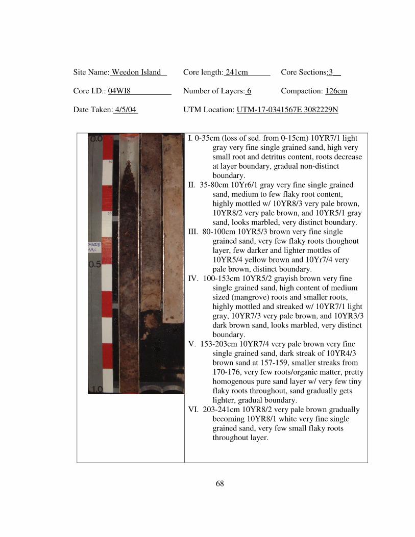
68
Site Name: Weedon Island Core length: 241cm Core Sections:3__
Core I.D.: 04WI8 Number of Layers: 6 Compaction: 126cm
Date Taken: 4/5/04 UTM Location: UTM-17-0341567E 3082229N
I. 0-35cm (loss of sed. from 0-15cm) 10YR7/1 light
gray very fine single grained sand, high very
small root and detritus content, roots decrease
at layer boundary, gradual non-distinct
boundary.
II. 35-80cm 10Yr6/1 gray very fine single grained
sand, medium to few flaky root content,
highly mottled w/ 10YR8/3 very pale brown,
10YR8/2 very pale brown, and 10YR5/1 gray
sand, looks marbled, very distinct boundary.
III. 80-100cm 10YR5/3 brown very fine single
grained sand, very few flaky roots thoughout
layer, few darker and lighter mottles of
10YR5/4 yellow brown and 10Yr7/4 very
pale brown, distinct boundary.
IV. 100-153cm 10YR5/2 grayish brown very fine
single grained sand, high content of medium
sized (mangrove) roots and smaller roots,
highly mottled and streaked w/ 10YR7/1 light
gray, 10YR7/3 very pale brown, and 10YR3/3
dark brown sand, looks marbled, very distinct
boundary.
V. 153-203cm 10YR7/4 very pale brown very fine
single grained sand, dark streak of 10YR4/3
brown sand at 157-159, smaller streaks from
170-176, very few roots/organic matter, pretty
homogenous pure sand layer w/ very few tiny
flaky roots throughout, sand gradually gets
lighter, gradual boundary.
VI. 203-241cm 10YR8/2 very pale brown gradually
becoming 10YR8/1 white very fine single
grained sand, very few small flaky roots
throughout layer.
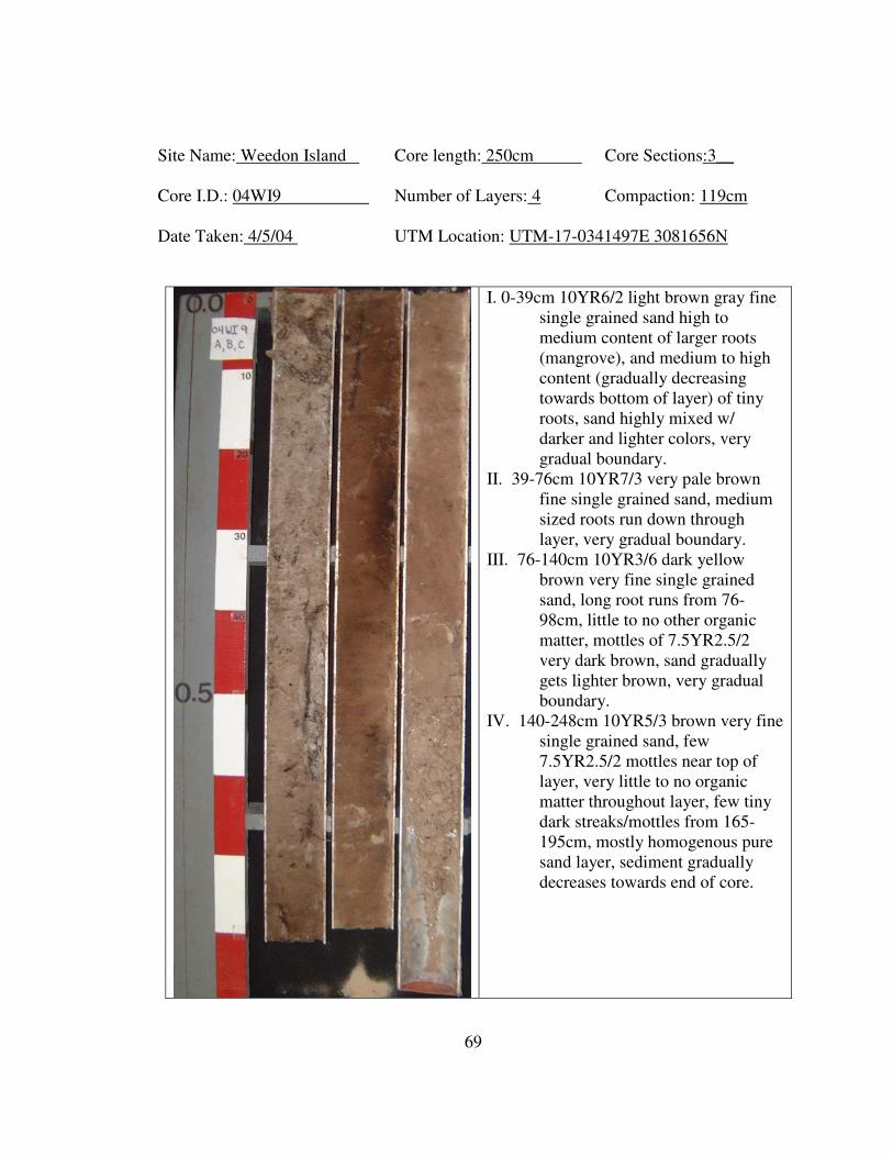
69
Site Name: Weedon Island Core length: 250cm Core Sections:3__
Core I.D.: 04WI9 Number of Layers: 4 Compaction: 119cm
Date Taken: 4/5/04 UTM Location: UTM-17-0341497E 3081656N
I. 0-39cm 10YR6/2 light brown gray fine
single grained sand high to
medium content of larger roots
(mangrove), and medium to high
content (gradually decreasing
towards bottom of layer) of tiny
roots, sand highly mixed w/
darker and lighter colors, very
gradual boundary.
II. 39-76cm 10YR7/3 very pale brown
fine single grained sand, medium
sized roots run down through
layer, very gradual boundary.
III. 76-140cm 10YR3/6 dark yellow
brown very fine single grained
sand, long root runs from 76-
98cm, little to no other organic
matter, mottles of 7.5YR2.5/2
very dark brown, sand gradually
gets lighter brown, very gradual
boundary.
IV. 140-248cm 10YR5/3 brown very fine
single grained sand, few
7.5YR2.5/2 mottles near top of
layer, very little to no organic
matter throughout layer, few tiny
dark streaks/mottles from 165-
195cm, mostly homogenous pure
sand layer, sediment gradually
decreases towards end of core.
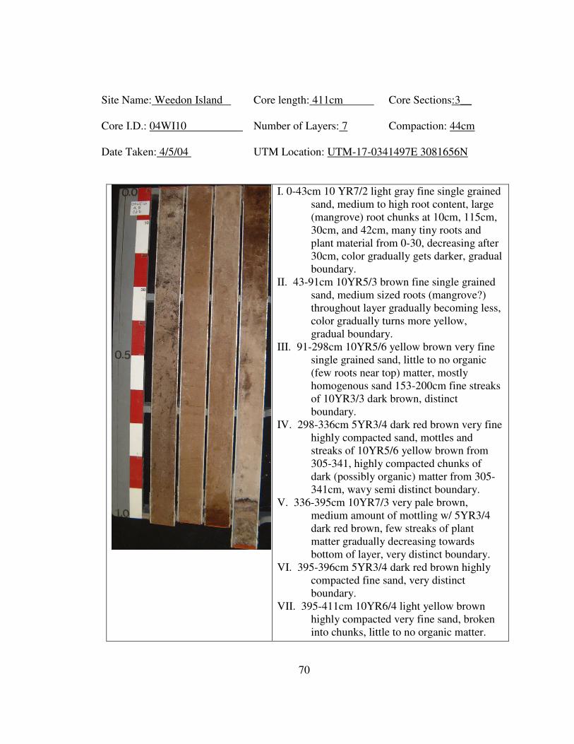
70
Site Name: Weedon Island Core length: 411cm Core Sections:3__
Core I.D.: 04WI10 Number of Layers: 7 Compaction: 44cm
Date Taken: 4/5/04 UTM Location: UTM-17-0341497E 3081656N
I. 0-43cm 10 YR7/2 light gray fine single grained
sand, medium to high root content, large
(mangrove) root chunks at 10cm, 115cm,
30cm, and 42cm, many tiny roots and
plant material from 0-30, decreasing after
30cm, color gradually gets darker, gradual
boundary.
II. 43-91cm 10YR5/3 brown fine single grained
sand, medium sized roots (mangrove?)
throughout layer gradually becoming less,
color gradually turns more yellow,
gradual boundary.
III. 91-298cm 10YR5/6 yellow brown very fine
single grained sand, little to no organic
(few roots near top) matter, mostly
homogenous sand 153-200cm fine streaks
of 10YR3/3 dark brown, distinct
boundary.
IV. 298-336cm 5YR3/4 dark red brown very fine
highly compacted sand, mottles and
streaks of 10YR5/6 yellow brown from
305-341, highly compacted chunks of
dark (possibly organic) matter from 305-
341cm, wavy semi distinct boundary.
V. 336-395cm 10YR7/3 very pale brown,
medium amount of mottling w/ 5YR3/4
dark red brown, few streaks of plant
matter gradually decreasing towards
bottom of layer, very distinct boundary.
VI. 395-396cm 5YR3/4 dark red brown highly
compacted fine sand, very distinct
boundary.
VII. 395-411cm 10YR6/4 light yellow brown
highly compacted very fine sand, broken
into chunks, little to no organic matter.
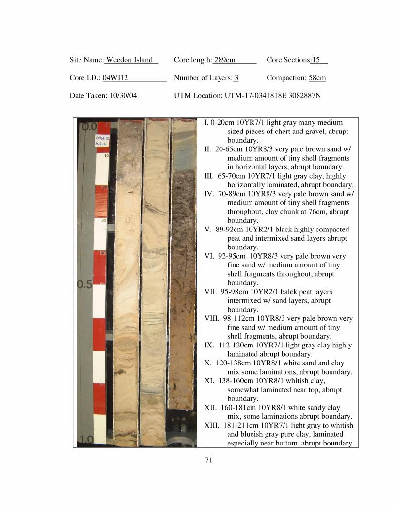
71
Site Name: Weedon Island Core length: 289cm Core Sections:15__
Core I.D.: 04WI12 Number of Layers: 3 Compaction: 58cm
Date Taken: 10/30/04 UTM Location: UTM-17-0341818E 3082887N
I. 0-20cm 10YR7/1 light gray many medium
sized pieces of chert and gravel, abrupt
boundary.
II. 20-65cm 10YR8/3 very pale brown sand w/
medium amount of tiny shell fragments
in horizontal layers, abrupt boundary.
III. 65-70cm 10YR7/1 light gray clay, highly
horizontally laminated, abrupt boundary.
IV. 70-89cm 10YR8/3 very pale brown sand w/
medium amount of tiny shell fragments
throughout, clay chunk at 76cm, abrupt
boundary.
V. 89-92cm 10YR2/1 black highly compacted
peat and intermixed sand layers abrupt
boundary.
VI. 92-95cm 10YR8/3 very pale brown very
fine sand w/ medium amount of tiny
shell fragments throughout, abrupt
boundary.
VII. 95-98cm 10YR2/1 balck peat layers
intermixed w/ sand layers, abrupt
boundary.
VIII. 98-112cm 10YR8/3 very pale brown very
fine sand w/ medium amount of tiny
shell fragments, abrupt boundary.
IX. 112-120cm 10YR7/1 light gray clay highly
laminated abrupt boundary.
X. 120-138cm 10YR8/1 white sand and clay
mix some laminations, abrupt boundary.
XI. 138-160cm 10YR8/1 whitish clay,
somewhat laminated near top, abrupt
boundary.
XII. 160-181cm 10YR8/1 white sandy clay
mix, some laminations abrupt boundary.
XIII. 181-211cm 10YR7/1 light gray to whitish
and blueish gray pure clay, laminated
especially near bottom, abrupt boundary.
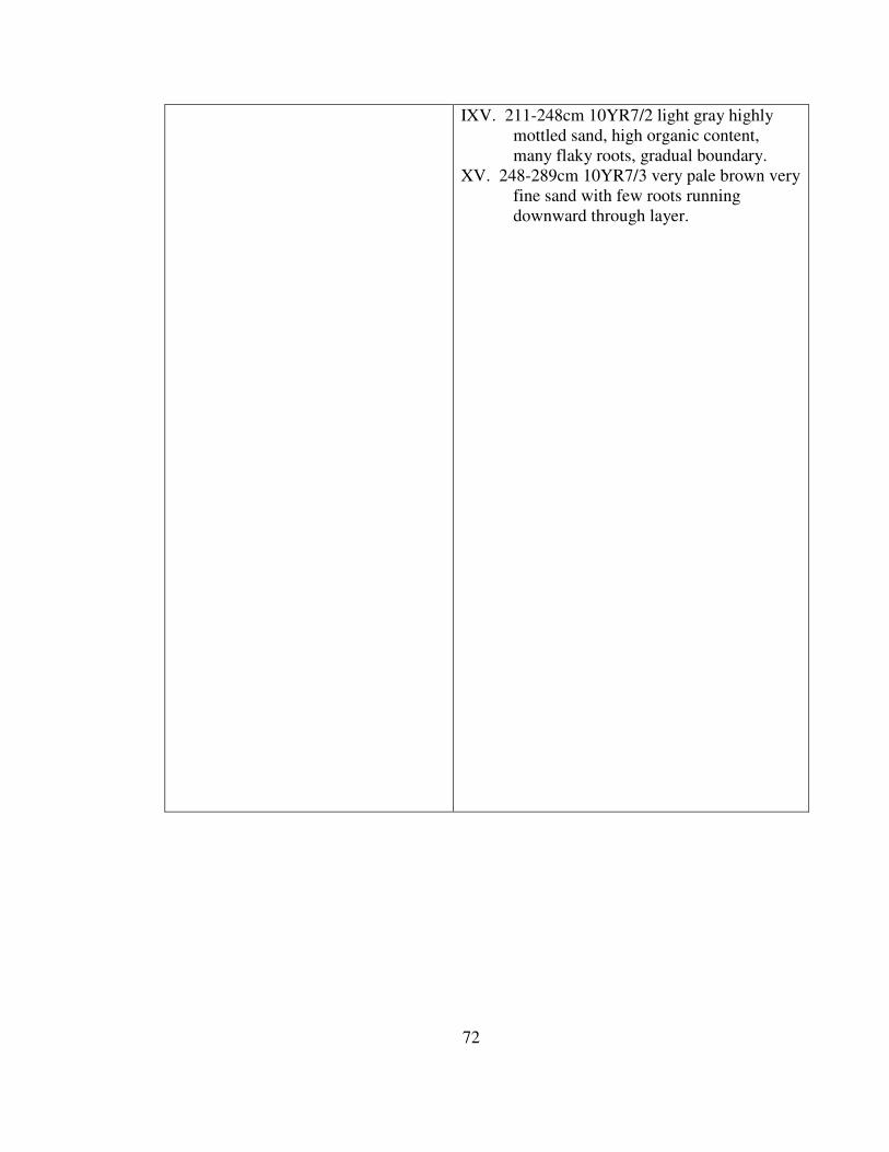
72
IXV. 211-248cm 10YR7/2 light gray highly
mottled sand, high organic content,
many flaky roots, gradual boundary.
XV. 248-289cm 10YR7/3 very pale brown very
fine sand with few roots running
downward through layer.
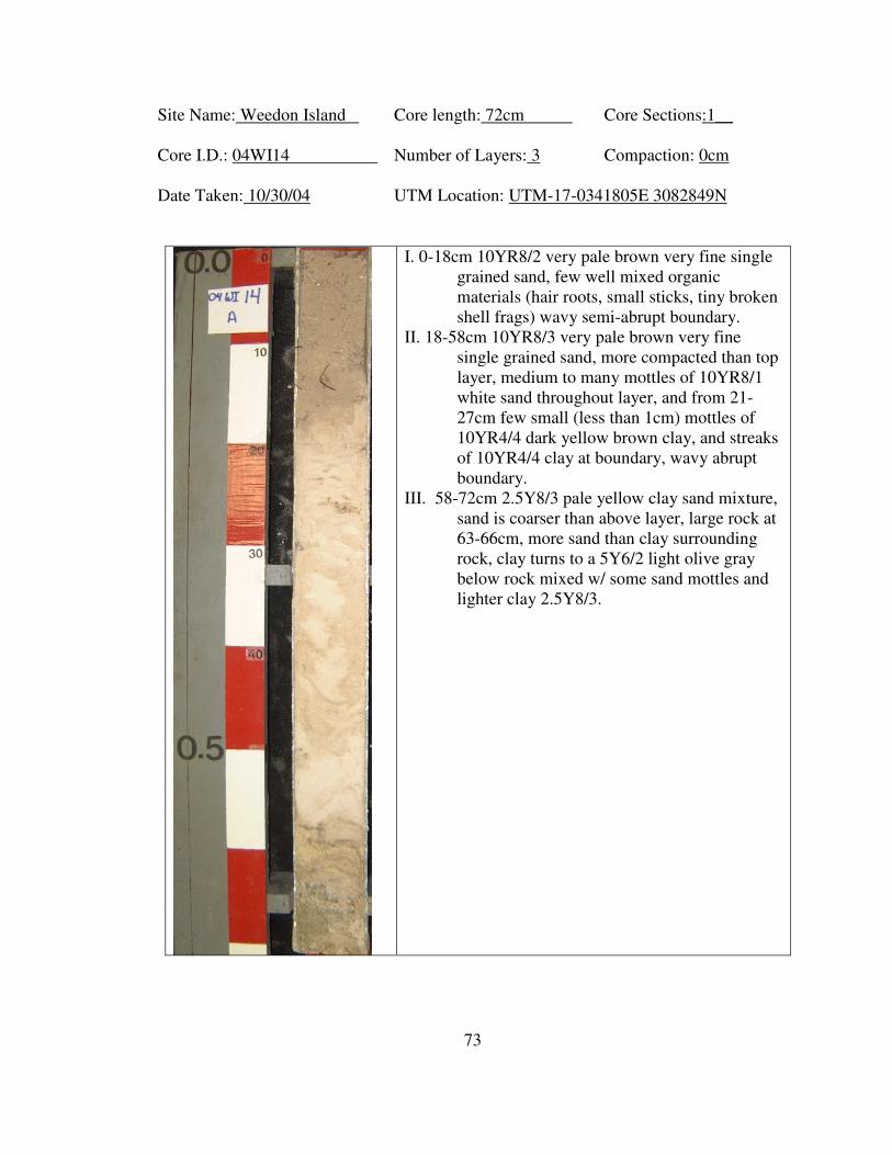
73
Site Name: Weedon Island Core length: 72cm Core Sections:1__
Core I.D.: 04WI14 Number of Layers: 3 Compaction: 0cm
Date Taken: 10/30/04 UTM Location: UTM-17-0341805E 3082849N
I. 0-18cm 10YR8/2 very pale brown very fine single
grained sand, few well mixed organic
materials (hair roots, small sticks, tiny broken
shell frags) wavy semi-abrupt boundary.
II. 18-58cm 10YR8/3 very pale brown very fine
single grained sand, more compacted than top
layer, medium to many mottles of 10YR8/1
white sand throughout layer, and from 21-
27cm few small (less than 1cm) mottles of
10YR4/4 dark yellow brown clay, and streaks
of 10YR4/4 clay at boundary, wavy abrupt
boundary.
III. 58-72cm 2.5Y8/3 pale yellow clay sand mixture,
sand is coarser than above layer, large rock at
63-66cm, more sand than clay surrounding
rock, clay turns to a 5Y6/2 light olive gray
below rock mixed w/ some sand mottles and
lighter clay 2.5Y8/3.
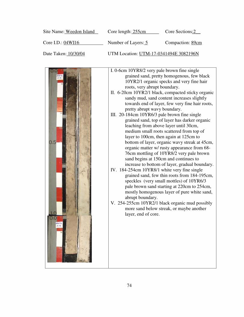
74
Site Name: Weedon Island Core length: 255cm Core Sections:2__
Core I.D.: 04WI16 Number of Layers: 5 Compaction: 89cm
Date Taken: 10/30/04 UTM Location: UTM-17-0341494E 3082196N
I. 0-6cm 10YR8/2 very pale brown fine single
grained sand, pretty homogenous, few black
10YR2/1 organic specks and very fine hair
roots, very abrupt boundary.
II. 6-20cm 10YR2/1 black, compacted sticky organic
sandy mud, sand content increases slightly
towards end of layer, few very fine hair roots,
pretty abrupt wavy boundary.
III. 20-184cm 10YR6/3 pale brown fine single
grained sand, top of layer has darker organic
leaching from above layer until 30cm,
medium small roots scattered from top of
layer to 100cm, then again at 125cm to
bottom of layer, organic wavy streak at 45cm,
organic matter w/ rusty appearance from 68-
76cm mottling of 10YR8/2 very pale brown
sand begins at 150cm and continues to
increase to bottom of layer, gradual boundary.
IV. 184-254cm 10YR8/1 white very fine single
grained sand, few thin roots from 184-195cm,
speckles (very small mottles) of 10YR6/3
pale brown sand starting at 220cm to 254cm,
mostly homogenous layer of pure white sand,
abrupt boundary.
V. 254-255cm 10YR2/1 black organic mud possibly
more sand below streak, or maybe another
layer, end of core.
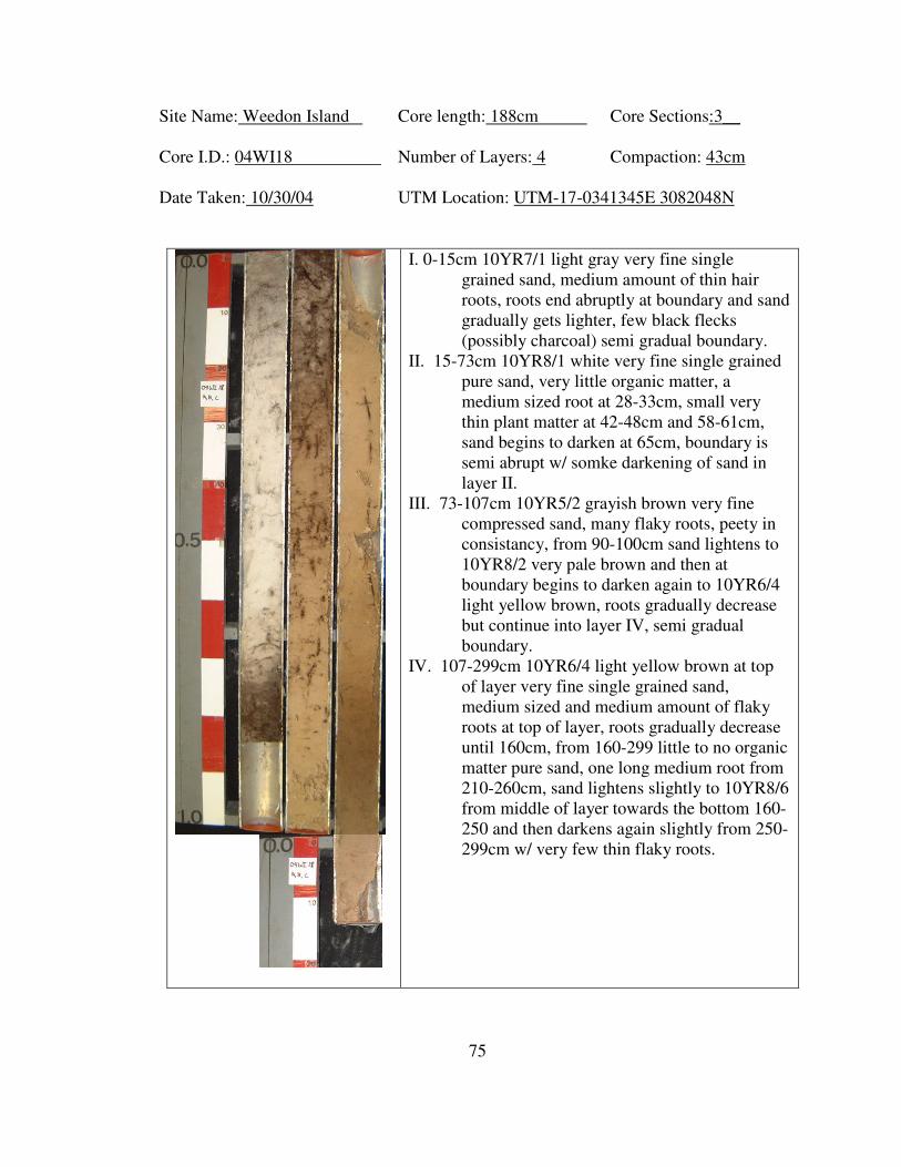
75
Site Name: Weedon Island Core length: 188cm Core Sections:3__
Core I.D.: 04WI18 Number of Layers: 4 Compaction: 43cm
Date Taken: 10/30/04 UTM Location: UTM-17-0341345E 3082048N
I. 0-15cm 10YR7/1 light gray very fine single
grained sand, medium amount of thin hair
roots, roots end abruptly at boundary and sand
gradually gets lighter, few black flecks
(possibly charcoal) semi gradual boundary.
II. 15-73cm 10YR8/1 white very fine single grained
pure sand, very little organic matter, a
medium sized root at 28-33cm, small very
thin plant matter at 42-48cm and 58-61cm,
sand begins to darken at 65cm, boundary is
semi abrupt w/ somke darkening of sand in
layer II.
III. 73-107cm 10YR5/2 grayish brown very fine
compressed sand, many flaky roots, peety in
consistancy, from 90-100cm sand lightens to
10YR8/2 very pale brown and then at
boundary begins to darken again to 10YR6/4
light yellow brown, roots gradually decrease
but continue into layer IV, semi gradual
boundary.
IV. 107-299cm 10YR6/4 light yellow brown at top
of layer very fine single grained sand,
medium sized and medium amount of flaky
roots at top of layer, roots gradually decrease
until 160cm, from 160-299 little to no organic
matter pure sand, one long medium root from
210-260cm, sand lightens slightly to 10YR8/6
from middle of layer towards the bottom 160-
250 and then darkens again slightly from 250-
299cm w/ very few thin flaky roots.
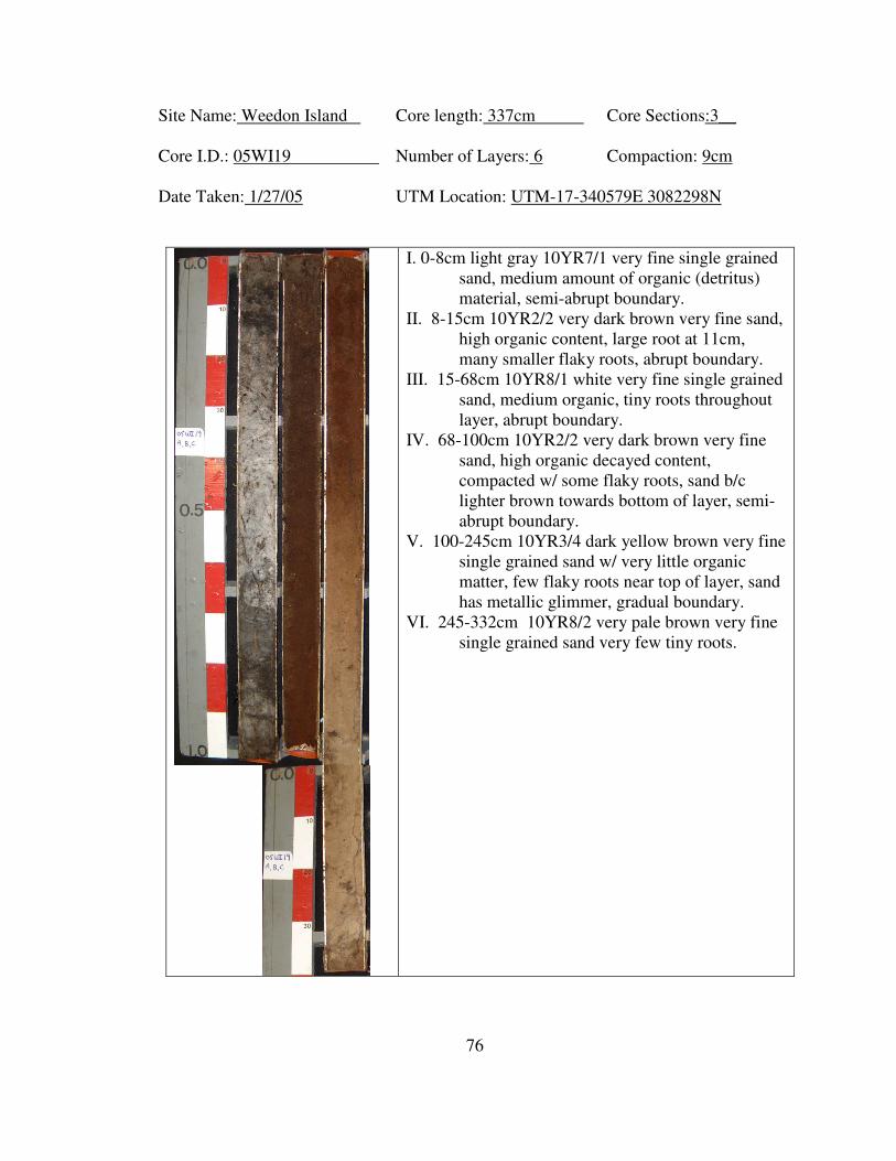
76
Site Name: Weedon Island Core length: 337cm Core Sections:3__
Core I.D.: 05WI19 Number of Layers: 6 Compaction: 9cm
Date Taken: 1/27/05 UTM Location: UTM-17-340579E 3082298N
I. 0-8cm light gray 10YR7/1 very fine single grained
sand, medium amount of organic (detritus)
material, semi-abrupt boundary.
II. 8-15cm 10YR2/2 very dark brown very fine sand,
high organic content, large root at 11cm,
many smaller flaky roots, abrupt boundary.
III. 15-68cm 10YR8/1 white very fine single grained
sand, medium organic, tiny roots throughout
layer, abrupt boundary.
IV. 68-100cm 10YR2/2 very dark brown very fine
sand, high organic decayed content,
compacted w/ some flaky roots, sand b/c
lighter brown towards bottom of layer, semi-
abrupt boundary.
V. 100-245cm 10YR3/4 dark yellow brown very fine
single grained sand w/ very little organic
matter, few flaky roots near top of layer, sand
has metallic glimmer, gradual boundary.
VI. 245-332cm 10YR8/2 very pale brown very fine
single grained sand very few tiny roots.
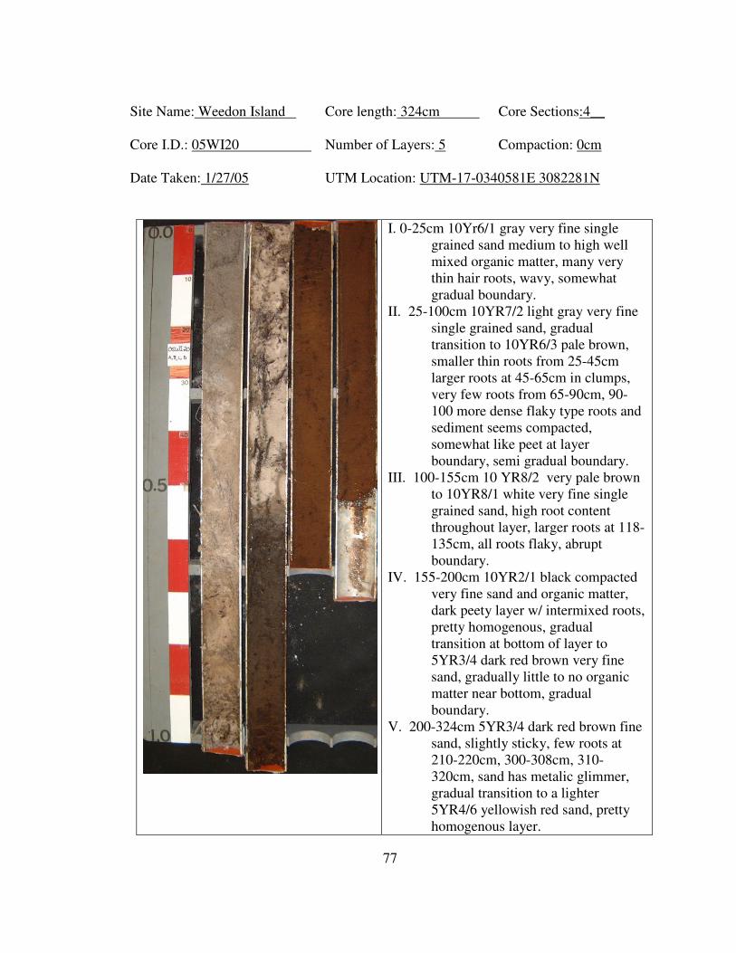
77
Site Name: Weedon Island Core length: 324cm Core Sections:4__
Core I.D.: 05WI20 Number of Layers: 5 Compaction: 0cm
Date Taken: 1/27/05 UTM Location: UTM-17-0340581E 3082281N
I. 0-25cm 10Yr6/1 gray very fine single
grained sand medium to high well
mixed organic matter, many very
thin hair roots, wavy, somewhat
gradual boundary.
II. 25-100cm 10YR7/2 light gray very fine
single grained sand, gradual
transition to 10YR6/3 pale brown,
smaller thin roots from 25-45cm
larger roots at 45-65cm in clumps,
very few roots from 65-90cm, 90-
100 more dense flaky type roots and
sediment seems compacted,
somewhat like peet at layer
boundary, semi gradual boundary.
III. 100-155cm 10 YR8/2 very pale brown
to 10YR8/1 white very fine single
grained sand, high root content
throughout layer, larger roots at 118-
135cm, all roots flaky, abrupt
boundary.
IV. 155-200cm 10YR2/1 black compacted
very fine sand and organic matter,
dark peety layer w/ intermixed roots,
pretty homogenous, gradual
transition at bottom of layer to
5YR3/4 dark red brown very fine
sand, gradually little to no organic
matter near bottom, gradual
boundary.
V. 200-324cm 5YR3/4 dark red brown fine
sand, slightly sticky, few roots at
210-220cm, 300-308cm, 310-
320cm, sand has metalic glimmer,
gradual transition to a lighter
5YR4/6 yellowish red sand, pretty
homogenous layer.
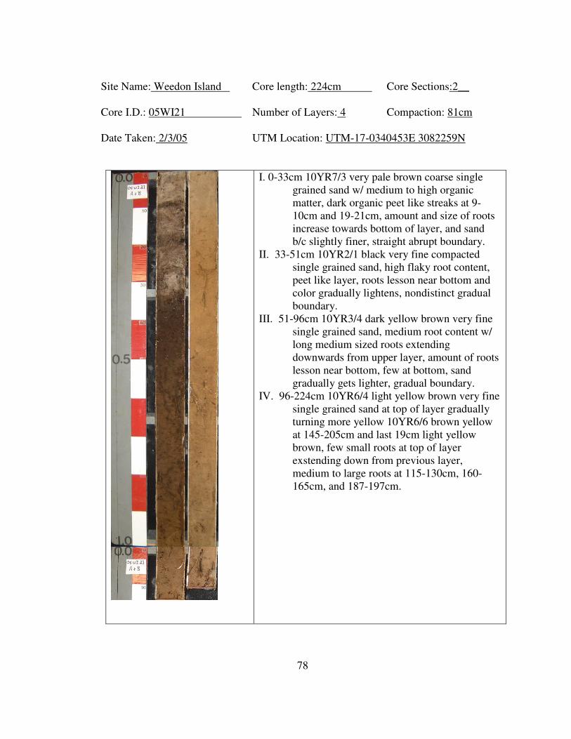
78
Site Name: Weedon Island Core length: 224cm Core Sections:2__
Core I.D.: 05WI21 Number of Layers: 4 Compaction: 81cm
Date Taken: 2/3/05 UTM Location: UTM-17-0340453E 3082259N
I. 0-33cm 10YR7/3 very pale brown coarse single
grained sand w/ medium to high organic
matter, dark organic peet like streaks at 9-
10cm and 19-21cm, amount and size of roots
increase towards bottom of layer, and sand
b/c slightly finer, straight abrupt boundary.
II. 33-51cm 10YR2/1 black very fine compacted
single grained sand, high flaky root content,
peet like layer, roots lesson near bottom and
color gradually lightens, nondistinct gradual
boundary.
III. 51-96cm 10YR3/4 dark yellow brown very fine
single grained sand, medium root content w/
long medium sized roots extending
downwards from upper layer, amount of roots
lesson near bottom, few at bottom, sand
gradually gets lighter, gradual boundary.
IV. 96-224cm 10YR6/4 light yellow brown very fine
single grained sand at top of layer gradually
turning more yellow 10YR6/6 brown yellow
at 145-205cm and last 19cm light yellow
brown, few small roots at top of layer
exstending down from previous layer,
medium to large roots at 115-130cm, 160-
165cm, and 187-197cm.
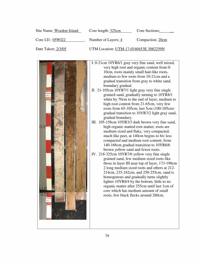
79
Site Name: Weedon Island Core length: 325cm Core Sections: __
Core I.D.: 05WI22 Number of Layers: 4 Compaction: 20cm
Date Taken: 2/3/05 UTM Location: UTM-17-0340453E 3082259N
I. 0-21cm 10YR6/1 gray very fine sand, well mixed,
very high root and organic content from 0-
10cm, roots mainly small hair-like roots,
medium to few roots from 10-21cm and a
gradual transition from gray to white sand,
boundary gradual.
II. 21-105cm 10YR7/1 light gray very fine single
grained sand, gradually turning to 10YR8/1
white by 70cm to the end of layer, medium to
high root content from 21-65cm, very few
roots from 65-105cm, last 5cm (100-105cm)
gradual transition to 10YR7/2 light gray sand,
gradual boundary.
III. 105-158cm 10YR3/3 dark brown very fine sand,
high organic matted root matter, roots are
medium sized and flaky, very compacted,
much like peet, at 140cm begins to b/c less
compacted and medium root content, from
140-168cm gradual transition to 10YR6/6
brown yellow sand and fewer roots.
IV. 218-325cm 10YR7/6 yellow very fine single
grained sand, few medium sized roots like
those in layer III near top of layer, 173-190cm
2 long medium sized roots and others at 212-
214cm, 235-242cm, and 250-255cm, sand is
homogenous and gradually turns slightly
lighter 10YR8/4 by the bottom, little to no
organic matter after 255cm until last 1cm of
core which has medium amount of small
roots, few black flecks around 280cm.
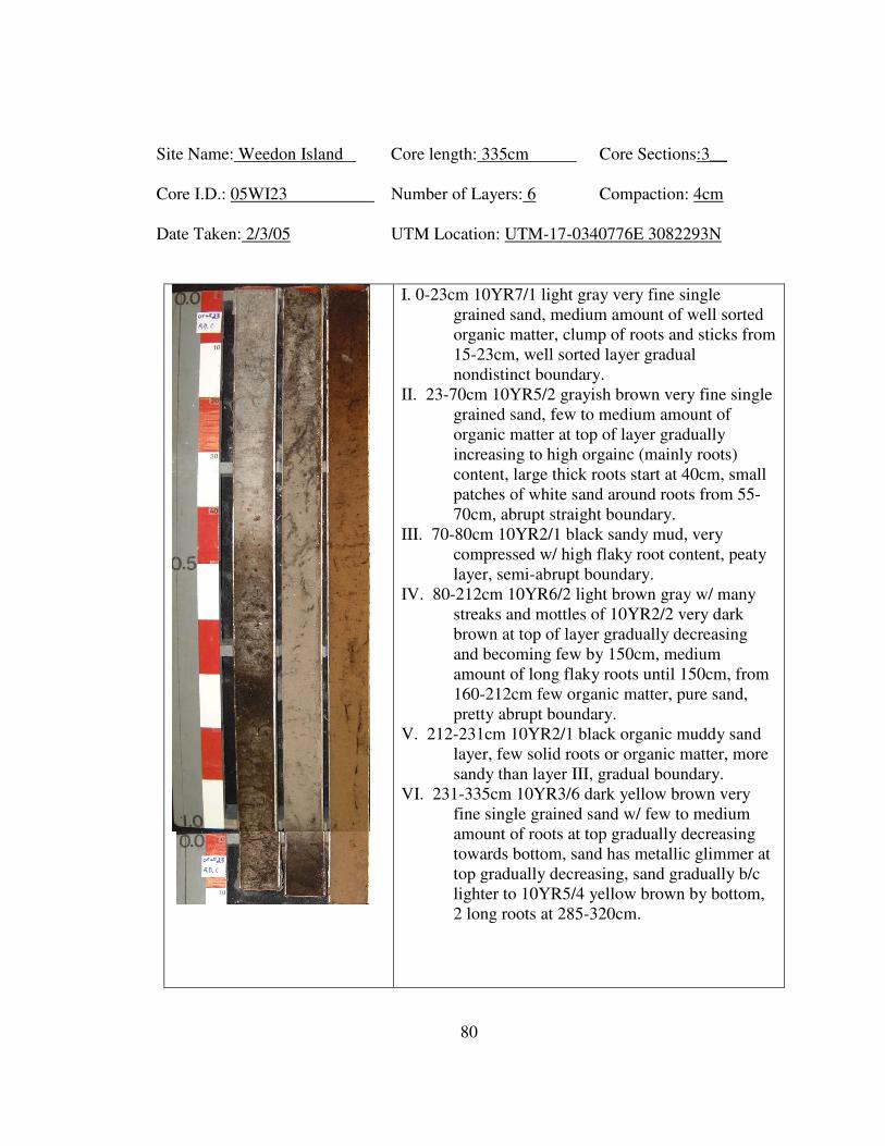
80
Site Name: Weedon Island Core length: 335cm Core Sections:3__
Core I.D.: 05WI23 Number of Layers: 6 Compaction: 4cm
Date Taken: 2/3/05 UTM Location: UTM-17-0340776E 3082293N
I. 0-23cm 10YR7/1 light gray very fine single
grained sand, medium amount of well sorted
organic matter, clump of roots and sticks from
15-23cm, well sorted layer gradual
nondistinct boundary.
II. 23-70cm 10YR5/2 grayish brown very fine single
grained sand, few to medium amount of
organic matter at top of layer gradually
increasing to high orgainc (mainly roots)
content, large thick roots start at 40cm, small
patches of white sand around roots from 55-
70cm, abrupt straight boundary.
III. 70-80cm 10YR2/1 black sandy mud, very
compressed w/ high flaky root content, peaty
layer, semi-abrupt boundary.
IV. 80-212cm 10YR6/2 light brown gray w/ many
streaks and mottles of 10YR2/2 very dark
brown at top of layer gradually decreasing
and becoming few by 150cm, medium
amount of long flaky roots until 150cm, from
160-212cm few organic matter, pure sand,
pretty abrupt boundary.
V. 212-231cm 10YR2/1 black organic muddy sand
layer, few solid roots or organic matter, more
sandy than layer III, gradual boundary.
VI. 231-335cm 10YR3/6 dark yellow brown very
fine single grained sand w/ few to medium
amount of roots at top gradually decreasing
towards bottom, sand has metallic glimmer at
top gradually decreasing, sand gradually b/c
lighter to 10YR5/4 yellow brown by bottom,
2 long roots at 285-320cm.
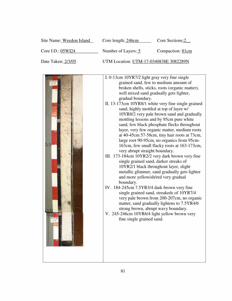
81
Site Name: Weedon Island Core length: 246cm Core Sections:2__
Core I.D.: 05WI24 Number of Layers: 5 Compaction: 81cm
Date Taken: 2/3/05 UTM Location: UTM-17-0340838E 3082289N
I. 0-13cm 10YR7/2 light gray very fine single
grained sand, few to medium amount of
broken shells, sticks, roots (organic matter),
well mixed sand gradually gets lighter,
gradual boundary.
II. 13-173cm 10YR8/1 white very fine single grained
sand, highly mottled at top of layer w/
10YR8/2 very pale brown sand and gradually
mottling lessons and by 95cm pure white
sand, few black phosphate flecks throughout
layer, very few organic matter, medium roots
at 40-45cm 57-58cm, tiny hair roots at 73cm,
large root 90-95cm, no organics from 95cm-
163cm, few small flacky roots at 163-173cm,
very abrupt straight boundary.
III. 173-184cm 10YR2/2 very dark brown very fine
single grained sand, darker streaks of
10YR2/1 black throughout layer, slight
metallic glimmer, sand gradually gets lighter
and more yellowish/red very gradual
boundary.
IV. 184-245cm 7.5YR3/4 dark brown very fine
single grained sand, streakeds of 10YR7/4
very pale brown from 200-207cm, no organic
matter, sand gradually lightens to 7.5YR4/6
strong brown, abrupt wavy boundary.
V. 245-246cm 10YR6/4 light yellow brown very
fine single grained sand.
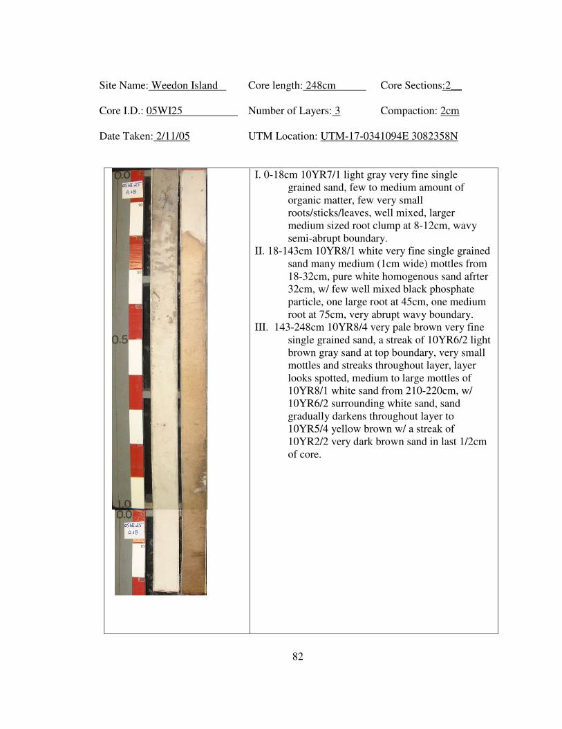
82
Site Name: Weedon Island Core length: 248cm Core Sections:2__
Core I.D.: 05WI25 Number of Layers: 3 Compaction: 2cm
Date Taken: 2/11/05 UTM Location: UTM-17-0341094E 3082358N
I. 0-18cm 10YR7/1 light gray very fine single
grained sand, few to medium amount of
organic matter, few very small
roots/sticks/leaves, well mixed, larger
medium sized root clump at 8-12cm, wavy
semi-abrupt boundary.
II. 18-143cm 10YR8/1 white very fine single grained
sand many medium (1cm wide) mottles from
18-32cm, pure white homogenous sand afrter
32cm, w/ few well mixed black phosphate
particle, one large root at 45cm, one medium
root at 75cm, very abrupt wavy boundary.
III. 143-248cm 10YR8/4 very pale brown very fine
single grained sand, a streak of 10YR6/2 light
brown gray sand at top boundary, very small
mottles and streaks throughout layer, layer
looks spotted, medium to large mottles of
10YR8/1 white sand from 210-220cm, w/
10YR6/2 surrounding white sand, sand
gradually darkens throughout layer to
10YR5/4 yellow brown w/ a streak of
10YR2/2 very dark brown sand in last 1/2cm
of core.
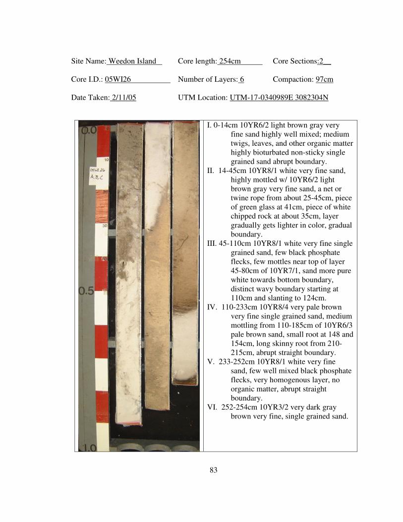
83
Site Name: Weedon Island Core length: 254cm Core Sections:2__
Core I.D.: 05WI26 Number of Layers: 6 Compaction: 97cm
Date Taken: 2/11/05 UTM Location: UTM-17-0340989E 3082304N
I. 0-14cm 10YR6/2 light brown gray very
fine sand highly well mixed; medium
twigs, leaves, and other organic matter
highly bioturbated non-sticky single
grained sand abrupt boundary.
II. 14-45cm 10YR8/1 white very fine sand,
highly mottled w/ 10YR6/2 light
brown gray very fine sand, a net or
twine rope from about 25-45cm, piece
of green glass at 41cm, piece of white
chipped rock at about 35cm, layer
gradually gets lighter in color, gradual
boundary.
III. 45-110cm 10YR8/1 white very fine single
grained sand, few black phosphate
flecks, few mottles near top of layer
45-80cm of 10YR7/1, sand more pure
white towards bottom boundary,
distinct wavy boundary starting at
110cm and slanting to 124cm.
IV. 110-233cm 10YR8/4 very pale brown
very fine single grained sand, medium
mottling from 110-185cm of 10YR6/3
pale brown sand, small root at 148 and
154cm, long skinny root from 210-
215cm, abrupt straight boundary.
V. 233-252cm 10YR8/1 white very fine
sand, few well mixed black phosphate
flecks, very homogenous layer, no
organic matter, abrupt straight
boundary.
VI. 252-254cm 10YR3/2 very dark gray
brown very fine, single grained sand.
84
Site Name: Weedon Island Core length: 289cm Core Sections:3__
Core I.D.: 05WI27 Number of Layers: 5 Compaction: 58cm
Date Taken: 2/11/05 UTM Location: UTM-17-0340838E 3082281N
I. 0-16cm 10YR6/2 light brown gray very fine
single grained sand, highly mixed w/
small twigs and other organic matter,
gradual boundary.
II. 16-73cm 10YR7/4 very pale brown very
fine single grained sand, highly
mottled w/ 10YR5/2 grayish brown
and 10YR8/2 very pale brown sand
appears highly disturbed, many tiny
hair roots and twigs from 16-40cm,
and few towards bottom of layer,
larger roots at 45cm, 50cm, and a very
thick root at 70cm (appears to be
mangrove).
III. 73-127cm from 10YR7/1 light gray near
top of layer and gradually becomes
10YR8/1 white at bottom of layer,
gradual transition, very fine single
grained sand few small roots from 73-
115cm, no roots in bottom of layer
abrupt straight boundary.
IV. 127-258cm 10YR5/1 gray gradual
transition to 10YR5/6 yellow brown at
bottom, many black phosphate flecks
and some mixed white sand like layer
III near top of layer, gradually
ddecreasing, gradual transition tp pure
very fine sand, small pieces of organic
matter (possibly decomposed root) at
205cm, sand has metalic glimmer
especially in second half of layer.
V. 258-289cm 10YR6/4 light yellow brown
highly mottled and streaked w/
10YR4/4 dark yellow brown very fine
single grained sand, no organic matter.
85
Site Name: Weedon Island Core length: 252cm Core Sections:2__
Core I.D.: 05WI28 Number of Layers: 3 Compaction: 45cm
Date Taken: 2/11/05 UTM Location: UTM-17-0340447E 3082342N
I. 0-17cm 10YR7/1 light gray very fine single
grained sand, very well mixed medium to
high orgainc content, many
large/medium/small roots and sticks from 11-
17cm, first 10cm many very small organic
frags, well mixed and homogenous, sand
gradually gets browner, gradual non-distinct
boundary.
II. 17-61cm 10YR7/3 very pale brown very fine
single grained sand, highly mottled and
streaked w/ 10YR7/1 light gray sand from 17-
40cm, and highly mottled w/ 10YR8/4 very
pale brown sand, 10YR8/6 yellow sand and
10YR7/1 light gray sand, appears marbled,
medium to high root content from 17-30cm
w/ medium and small sized roots, few small
roots, abrupt straight boundary, one large root
from 55-65 through boundary.
III. 61-252cm 10YR8/6 yellow very fine single
grained sand, medium to few orgainc root
content from 61-140cm long roots from 130-
140cm, scattered smaller roots from 61-
130cm, mottling of 10YR6/6 brown yellow
and 10YR7/3 very pale brown from 61-77cm,
w/ a streak at 70-75cm, one long medium
sized root from 181-194, sand gradually gets
lighter thoughout layer becoming 10YR8/4
very pale brown at bottom, few mottles of
10YR7/2 light gray from 200-220cm, one
large mottle of 10YR6/4 from 250-252cm,
mostly pure homogenous sand from 140-
252cm.
86
Site Name: Weedon Island Core length: 230cm Core Sections:2__
Core I.D.: 05WI29 Number of Layers: 4 Compaction: 38cm
Date Taken: 2/17/05 UTM Location: UTM-17-0341551E 3081883N
I. 0-30cm 10YR7/1 light gray very fine single grained
sand, very high organic content, many small
medium sized roots from 5-15cm, smaller
broken organic matter in first 5cm, roots and
sticks throughout layer, sand gradually gets
lighter, very gradual boundary.
II. 30-157cm 10YR7/2 light gray very fine single
grained sand, very high amount of medium
sized roots thoughout rest of layer, many
10YR8/1 white mottles from 50-70cm making a
marbled appearance, white sand seems to have
mixed into layer from 70-157 giving a frosted
appearance, semi abrupt wavy boundary.
III. 157-205cm 10YR3/2 very dark gray brown very
fine single grained sand, from 157-180cm many
small mottles of 10YR7/2 light gray sand,
mottles gradually decrease, medium root from
157-163cm, 172-176cm, and 180-190cm, sand
gradually lightens after 195cm, sand has frosty
appearance throughout layer, very gradual
boundary.
IV. 205-230cm 10YR5/3 brown very fine single
grained sand, medium root at 205-207cm,
210cm, and 220cm, few roots compared to
above layers, sand appears frosted.
87
Site Name: Weedon Island Core length: 299cm Core Sections:3__
Core I.D.: 05WI30 Number of Layers: 5 Compaction: 38cm
Date Taken: 2/17/05 UTM Location: UTM-17-0342022E 3082103N
I. 0-35cm 10YR5/1 gray fine single grained
sand, high content of leaf litter, and
organic matter from 0-10cm, few from
10-25cm, 25-35cm medium amount of
medium sized roots, sand gradually
gets lighter, gradual boundary.
II. 35-86cm 10YR7/1 light gray to 10YR8/1
white very fine single grained sand,
few very small roots from 35-45cm
and one large root at 40-45cm, very
few to no organic matter and fine roots
throughout rest of layer, pretty
homogenous pure white sand, very
abrupt straight boundary.
III. 86-108cm 10YR3/3 dark brown very fine
compacted single grained sand and
organic matter, medium to many flaky
roots and organic matter, somewhat
peety layer, homogenous, abrupt
straight boundary.
IV. 108-145cm 5YR4/6 yellowish red fine
single grained sand, sand has metallic
glimmer, few decomposing larger
roots at 110cm and 125-135cm, few
medium sized roots from 135-145cm,
sand gradually gets lighter, gradual
boundary.
V. 145-299cm 10YR6/4 light yellow brown
very fine single grained sand gradually
lightening to 10YR7/3 very pale brown
sand by 195cm, medium amount of
medium sized roots running downward
throughout layer, pretty homogenous
layer.
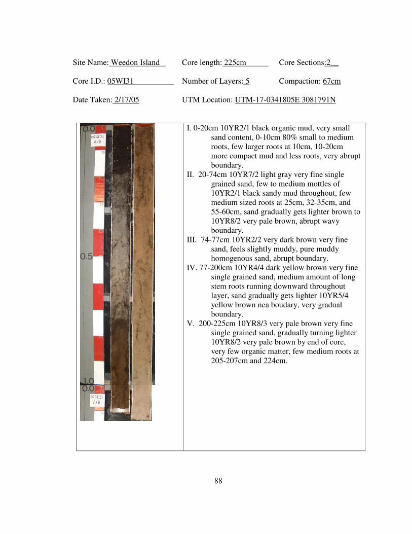
88
Site Name: Weedon Island Core length: 225cm Core Sections:2__
Core I.D.: 05WI31 Number of Layers: 5 Compaction: 67cm
Date Taken: 2/17/05 UTM Location: UTM-17-0341805E 3081791N
I. 0-20cm 10YR2/1 black organic mud, very small
sand content, 0-10cm 80% small to medium
roots, few larger roots at 10cm, 10-20cm
more compact mud and less roots, very abrupt
boundary.
II. 20-74cm 10YR7/2 light gray very fine single
grained sand, few to medium mottles of
10YR2/1 black sandy mud throughout, few
medium sized roots at 25cm, 32-35cm, and
55-60cm, sand gradually gets lighter brown to
10YR8/2 very pale brown, abrupt wavy
boundary.
III. 74-77cm 10YR2/2 very dark brown very fine
sand, feels slightly muddy, pure muddy
homogenous sand, abrupt boundary.
IV. 77-200cm 10YR4/4 dark yellow brown very fine
single grained sand, medium amount of long
stem roots running downward throughout
layer, sand gradually gets lighter 10YR5/4
yellow brown nea boudary, very gradual
boundary.
V. 200-225cm 10YR8/3 very pale brown very fine
single grained sand, gradually turning lighter
10YR8/2 very pale brown by end of core,
very few organic matter, few medium roots at
205-207cm and 224cm.
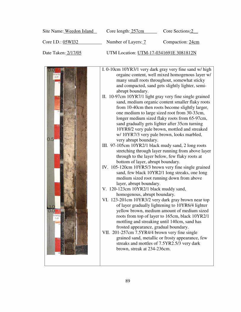
89
Site Name: Weedon Island Core length: 257cm Core Sections:2__
Core I.D.: 05WI32 Number of Layers: 7 Compaction: 24cm
Date Taken: 2/17/05 UTM Location: UTM-17-0341691E 3081812N
I. 0-10cm 10YR3/1 very dark gray very fine sand w/ high
orgainc content, well mixed homogenous layer w/
many small roots throughout, somewhat sticky
and compacted, sand gets slightly lighter, semi-
abrupt boundary.
II. 10-97cm 10YR7/1 light gray very fine single grained
sand, medium organic content smaller flaky roots
from 10-40cm then roots become slightly larger,
one medium to large sized root from 30-33cm,
longer medium sized flaky roots from 65-97cm,
sand gradually gets lighter after 35cm turning
10YR8/2 very pale brown, mottled and streaked
w/ 10YR7/3 very pale brown, looks marbled,
very abrupt boundary.
III. 97-105cm 10YR2/1 black mudy sand, 2 long roots
stretching through layer running from above layer
through to the layer below, few flaky roots at
bottom of layer, abrupt boundary.
IV. 105-120cm 10YR5/3 brown very fine single grained
sand, few black 10YR2/1 long streaks, one long
medium sized root running down from above
layer, abrupt boundary.
V. 120-123cm 10YR2/1 black muddy sand,
homogenous, abrupt boundary.
VI. 123-201cm 10YR3/2 very dark gray brown near top
of layer gradually lightening to 10YR6/4 lighter
yellow brown, medium amount of medium sized
roots from top of layer to 165cm, black 10YR2/1
mottling and streaking until 140cm, sand has
frosted appearance, gradual boundary.
VII. 201-257cm 7.5YR4/4 brown very fine single
grained sand, metallic or frosty appearance, few
streaks and mottles of 7.5YR2.5/3 very dark
brown, streak at 234-236cm.
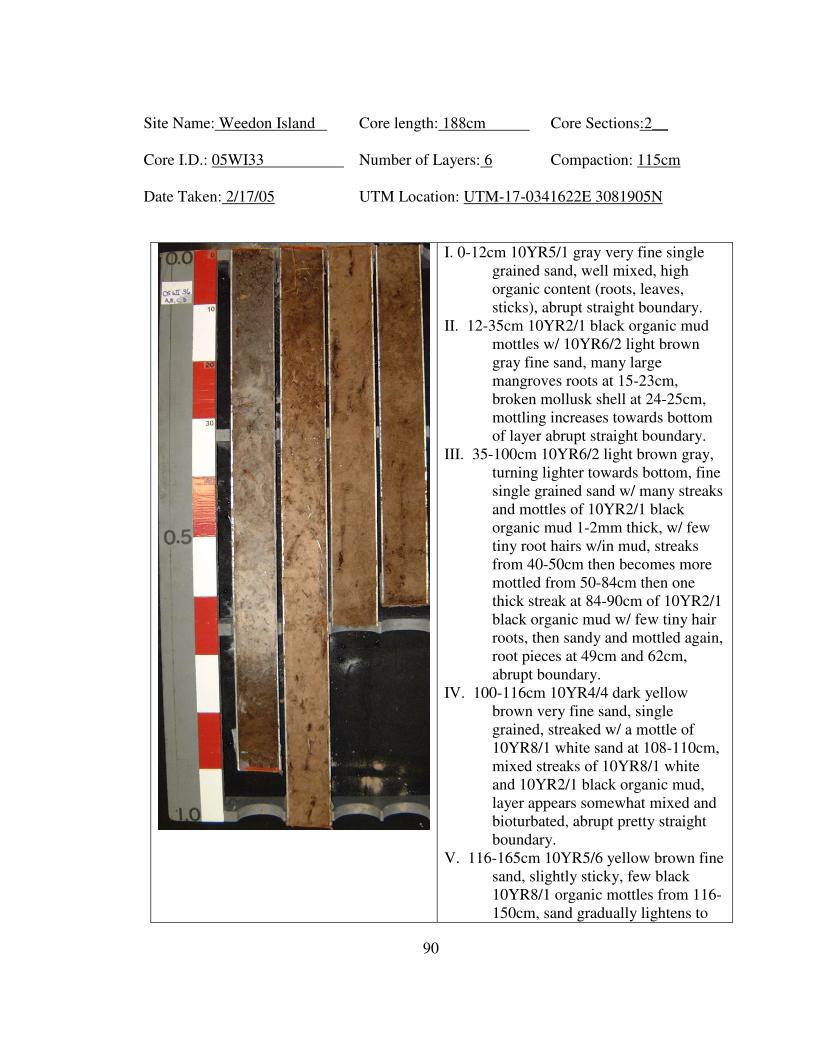
90
Site Name: Weedon Island Core length: 188cm Core Sections:2__
Core I.D.: 05WI33 Number of Layers: 6 Compaction: 115cm
Date Taken: 2/17/05 UTM Location: UTM-17-0341622E 3081905N
I. 0-12cm 10YR5/1 gray very fine single
grained sand, well mixed, high
organic content (roots, leaves,
sticks), abrupt straight boundary.
II. 12-35cm 10YR2/1 black organic mud
mottles w/ 10YR6/2 light brown
gray fine sand, many large
mangroves roots at 15-23cm,
broken mollusk shell at 24-25cm,
mottling increases towards bottom
of layer abrupt straight boundary.
III. 35-100cm 10YR6/2 light brown gray,
turning lighter towards bottom, fine
single grained sand w/ many streaks
and mottles of 10YR2/1 black
organic mud 1-2mm thick, w/ few
tiny root hairs w/in mud, streaks
from 40-50cm then becomes more
mottled from 50-84cm then one
thick streak at 84-90cm of 10YR2/1
black organic mud w/ few tiny hair
roots, then sandy and mottled again,
root pieces at 49cm and 62cm,
abrupt boundary.
IV. 100-116cm 10YR4/4 dark yellow
brown very fine sand, single
grained, streaked w/ a mottle of
10YR8/1 white sand at 108-110cm,
mixed streaks of 10YR8/1 white
and 10YR2/1 black organic mud,
layer appears somewhat mixed and
bioturbated, abrupt pretty straight
boundary.
V. 116-165cm 10YR5/6 yellow brown fine
sand, slightly sticky, few black
10YR8/1 organic mottles from 116-
150cm, sand gradually lightens to
91
10YR6/4 light yellow brown at
bottom of layer.
VI. 165-185cm 10YR5/3 brown very fine
sand, very mottled w/ 10YR6/4
light yellow brown sand and one big
mottle of 10YR5/6 yellow brown
sand at top boundary from 165-
168cm

92
Site Name: Weedon Island Core length: 170cm Core Section:2__
Core I.D.: 05WI34 Number of layers: 5 Compaction: 161.5cm
Date Taken: 2/24/05 UTM Location: 17-0341204E 3082756N
I. 0-25cm 10YR4/1 dark gray homogeneous oxidized
sand, clear quartz grains, loose single grained,
with few to common fine rootlets and
charcoal flecks, few medium oak roots near
base, few scattered small shell fragments in
lower 10cm (oyster lighting whelk), clear
wavy boundary.
II. 25-48cm 10YR3/2 very dark grayish brown
slightly organic fine sand, clear quartz grains,
few fine dark grayish mottles, loose, single
grained to weakly granular structure, 30% of
matrix is shells (eastern oyster, crown conch,
lightning whelk, moonsnail), some animal
bone fragments, few fine roots at top, few fine
charcoal flecks, clear wavy boundary.
III. 45-59cm 10YR4/2 dark grayish brown becoming
10YR5/2 grayish brown fine sand, loose,
single grained to weakly granular structure,
trace amount of shell (moonsnail and oyster
fragments), few fine roots, clear quartz grains,
irregular boundary, possible root/bioturbation,
few fine pale brown mottles, with midden
organics and shells and leaching from zone II.
IV. 58-134cm 10YR7/4 very brown to 10YR7/6
yellow fine sand, loose, single grained, 58-
80cm bioturbated with 10YR5/3 brown and
10YR6/3 pale brown mottles and common
roots, yellow sand has a few medium roots at
105 and 115-132cm, faint charcoal
impressions, clear smooth boundary, yellow
qurtz grains mixed with clear.
V. 134-170cm 10YR7/3 becoming 10YR8/2 very
pale brown fine sand, loose, single grained,
fairly homogeneous, few root fragments at
150-165cm, mixture of clear patinated quartz
134-140cm, below is clear quartz.
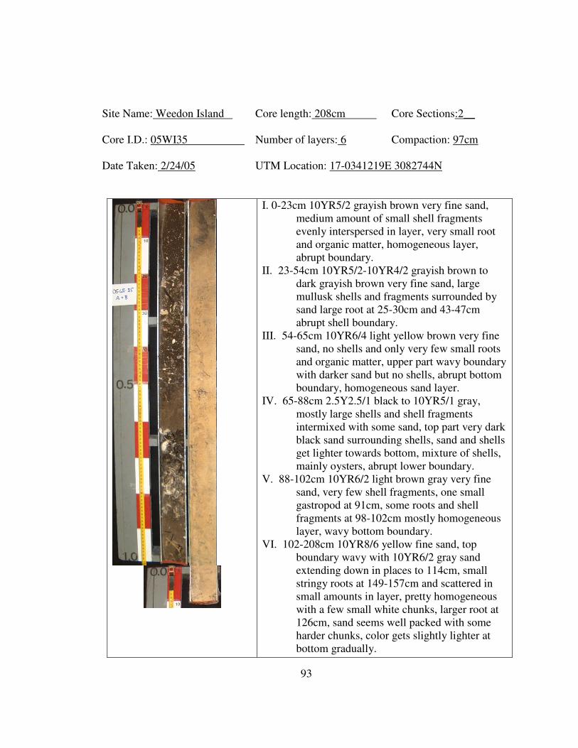
93
Site Name: Weedon Island Core length: 208cm Core Sections:2__
Core I.D.: 05WI35 Number of layers: 6 Compaction: 97cm
Date Taken: 2/24/05 UTM Location: 17-0341219E 3082744N
I. 0-23cm 10YR5/2 grayish brown very fine sand,
medium amount of small shell fragments
evenly interspersed in layer, very small root
and organic matter, homogeneous layer,
abrupt boundary.
II. 23-54cm 10YR5/2-10YR4/2 grayish brown to
dark grayish brown very fine sand, large
mullusk shells and fragments surrounded by
sand large root at 25-30cm and 43-47cm
abrupt shell boundary.
III. 54-65cm 10YR6/4 light yellow brown very fine
sand, no shells and only very few small roots
and organic matter, upper part wavy boundary
with darker sand but no shells, abrupt bottom
boundary, homogeneous sand layer.
IV. 65-88cm 2.5Y2.5/1 black to 10YR5/1 gray,
mostly large shells and shell fragments
intermixed with some sand, top part very dark
black sand surrounding shells, sand and shells
get lighter towards bottom, mixture of shells,
mainly oysters, abrupt lower boundary.
V. 88-102cm 10YR6/2 light brown gray very fine
sand, very few shell fragments, one small
gastropod at 91cm, some roots and shell
fragments at 98-102cm mostly homogeneous
layer, wavy bottom boundary.
VI. 102-208cm 10YR8/6 yellow fine sand, top
boundary wavy with 10YR6/2 gray sand
extending down in places to 114cm, small
stringy roots at 149-157cm and scattered in
small amounts in layer, pretty homogeneous
with a few small white chunks, larger root at
126cm, sand seems well packed with some
harder chunks, color gets slightly lighter at
bottom gradually.
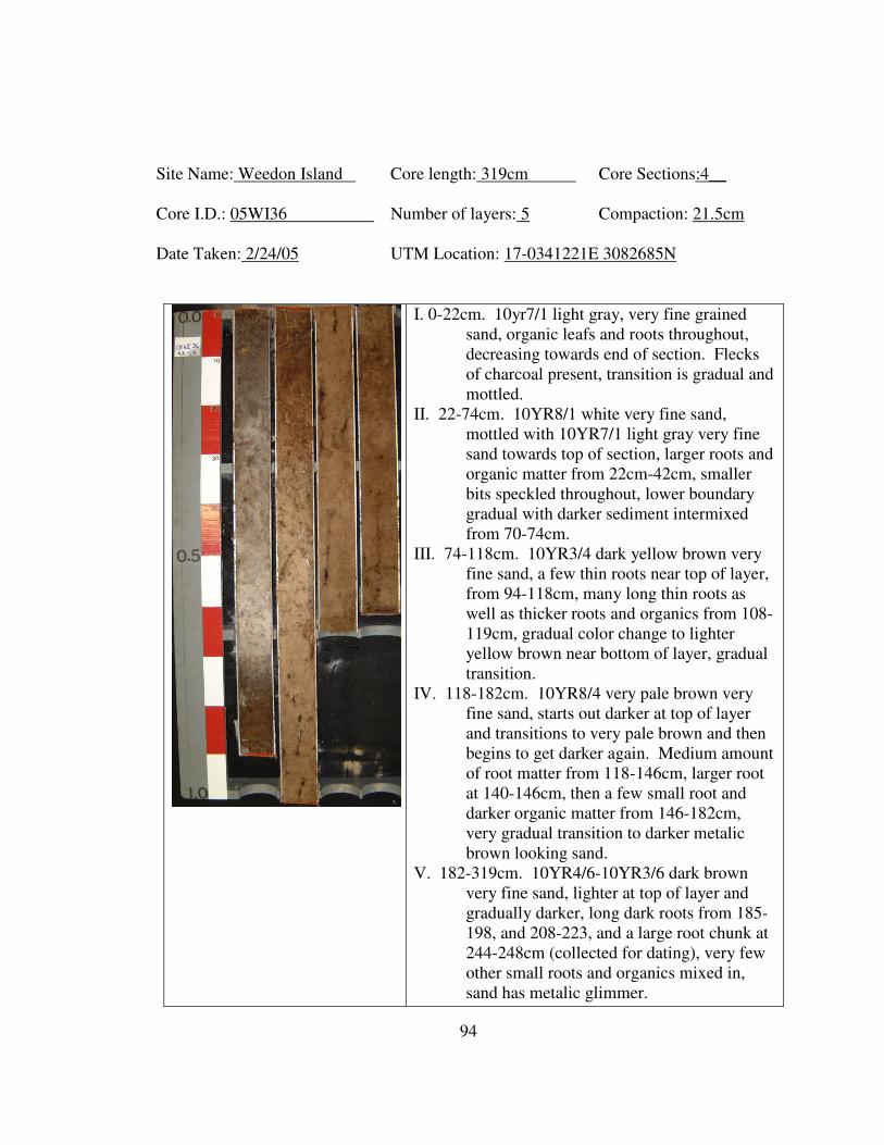
94
Site Name: Weedon Island Core length: 319cm Core Sections:4__
Core I.D.: 05WI36 Number of layers: 5 Compaction: 21.5cm
Date Taken: 2/24/05 UTM Location: 17-0341221E 3082685N
I. 0-22cm. 10yr7/1 light gray, very fine grained
sand, organic leafs and roots throughout,
decreasing towards end of section. Flecks
of charcoal present, transition is gradual and
mottled.
II. 22-74cm. 10YR8/1 white very fine sand,
mottled with 10YR7/1 light gray very fine
sand towards top of section, larger roots and
organic matter from 22cm-42cm, smaller
bits speckled throughout, lower boundary
gradual with darker sediment intermixed
from 70-74cm.
III. 74-118cm. 10YR3/4 dark yellow brown very
fine sand, a few thin roots near top of layer,
from 94-118cm, many long thin roots as
well as thicker roots and organics from 108-
119cm, gradual color change to lighter
yellow brown near bottom of layer, gradual
transition.
IV. 118-182cm. 10YR8/4 very pale brown very
fine sand, starts out darker at top of layer
and transitions to very pale brown and then
begins to get darker again. Medium amount
of root matter from 118-146cm, larger root
at 140-146cm, then a few small root and
darker organic matter from 146-182cm,
very gradual transition to darker metalic
brown looking sand.
V. 182-319cm. 10YR4/6-10YR3/6 dark brown
very fine sand, lighter at top of layer and
gradually darker, long dark roots from 185-
198, and 208-223, and a large root chunk at
244-248cm (collected for dating), very few
other small roots and organics mixed in,
sand has metalic glimmer.
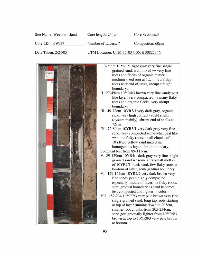
95
Site Name: Weedon Island Core length: 234cm Core Sections:3__
Core I.D.: 05WI37 Number of Layers: 7 Compaction: 60cm
Date Taken: 2/24/05 UTM Location: UTM-17-0341063E 3082734N
I. 0-27cm 10YR7/1 light gray very fine single
grained sand, well mixed w/ very fine
roots and flecks of organic matter,
medium sized root at 12cm, few flaky
roots near end of layer, abrupt straight
boundary.
II. 27-49cm 10YR4/3 brown very fine sandy peat
like layer, very compacted w/ many flaky
roots and organic flecks, very abrupt
boundary.
III. 49-72cm 10YR3/1 very dark gray, organic
sand, very high content (90%) shells
(oysters mainly), abrupt end of shells at
72cm.
IV. 72-89cm 10YR3/1 very dark gray very fine
sand, very compacted some what peat like
w/ some flaky roots, small chunks of
10YR8/6 yellow sand mixed in,
homogenous layer, abrupt boundary.
Sediment lost from 89-115cm.
V. 89-129cm 10YR4/1 dark gray very fine single
grained sand w/ some very small mottles
of 10YR2/1 black sand, few flaky roots at
bootom of layer, semi gradual boundary.
VI. 129-157cm 10YR2/2 very dark brown very
fine sandy peat, highly compacted
especially middle of layer, w/ flaky roots,
semi gradual boundary as sand becomes
less compacted and lighter in color.
VII. 157-234 10YR7/3 very pale brown very fine
single grained sand, long tap roots starting
at top of layer running down to 205cm,
smaller root chunks from 205-234cm,
sand gets gradually lighter from 10YR5/3
brown at top to 10YR8/3 very pale brown
at bottom.
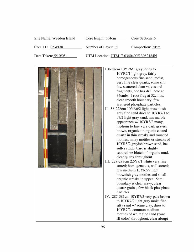
96
Site Name: Weedon Island Core length: 504cm Core Sections:6__
Core I.D.: 05WI38 Number of Layers: 6 Compaction: 70cm
Date Taken: 5/10/05 UTM Location: UTM17-0340400E 3082184N
I. 0-38cm 10YR6/1 gray, dries to
10YR7/1 light gray, fairly
homogeneous fine sand, moist,
very fine clear quartz, some silt;
few scattered clam valves and
fragments, one has drill hole at
34cmbs, 1 root frag at 32cmbs,
clear smooth boundary; few
scattered phosphate particles.
II. 38-228cm 10YR6/2 light browniosh
gray fine sand dries to 10YR7/1 to
b7/2 light gray sand, has marble
appearance w/ 10YR3/2 many,
medium to fine very dark grayish
brown, organic or organic coated
quartz in thin streaks and rounded
mottles, mnay mottles or streaks of
10YR5/2 grayish brown sand, has
sulfer smell, base is slighly
scoured w/ blotch of organic mud,
clear quartz throughout.
III. 228-287cm 2.5Y8/1 white very fine
sorted; homogeneous, well sorted;
few medium 10YR6/2 light
brownish gray mottles and small
organic streaks in upper 15cm,
boundary is clear wavy; clear
quartz grains, few black phosphate
particles.
IV. 287-381cm 10YR7/3 very pale brown
to 10YR7/2 light gray moist fine
silty sand w/ some clay, dries to
10YR7/2, common medium
mottles of white fine sand (zone
III color) throughout, clear abrupt
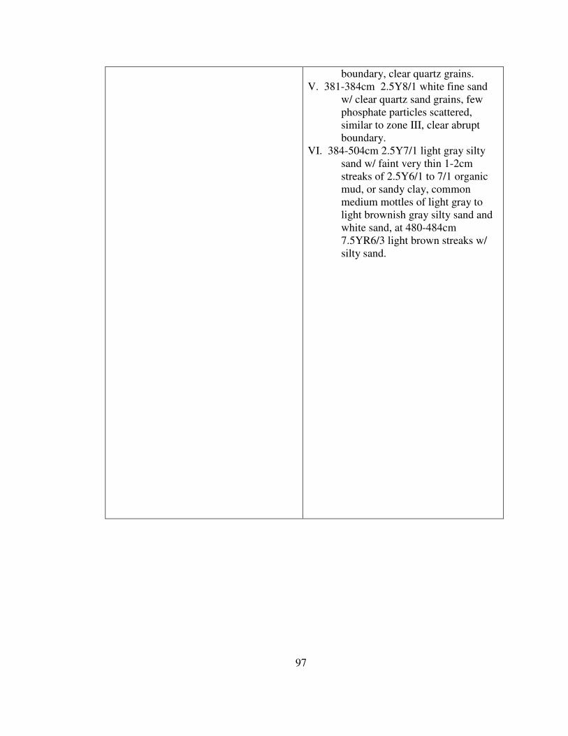
97
boundary, clear quartz grains.
V. 381-384cm 2.5Y8/1 white fine sand
w/ clear quartz sand grains, few
phosphate particles scattered,
similar to zone III, clear abrupt
boundary.
VI. 384-504cm 2.5Y7/1 light gray silty
sand w/ faint very thin 1-2cm
streaks of 2.5Y6/1 to 7/1 organic
mud, or sandy clay, common
medium mottles of light gray to
light brownish gray silty sand and
white sand, at 480-484cm
7.5YR6/3 light brown streaks w/
silty sand.
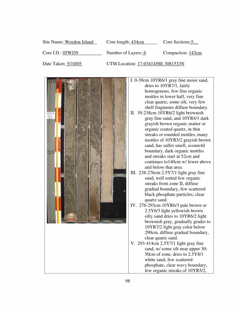
98
Site Name: Weedon Island Core length: 434cm Core Sections:5__
Core I.D.: 05WI39 Number of Layers: 6 Compaction: 143cm
Date Taken: 5/10/05 UTM Location: 17-0341458E 3081533N
I. 0-39cm 10YR6/1 gray fine moist sand,
dries to 10YR7/1, fairly
homogenous, few fine organic
mottles in lower half, very fine
clear quartz, some silt, very few
shell fragments diffuse boundary.
II. 39-238cm 10YR6/2 light brownish
gray fine sand, and 10YR4/1 dark
grayish brown organic matter or
organic coated quartz, in thin
streaks or rounded mottles, many
mottles of 10YR5/2 grayish brown
sand, has sulfer smell, scoure4d
boundary, dark organic mottles
and streaks start at 52cm and
continues to140cm w/ fewer above
and below that area.
III. 238-276cm 2.5Y7/1 light gray fine
sand, well sorted few organic
streaks from zone II, diffuse
gradual boundary, few scattered
black phosphate particles; clear
quartz sand.
IV. 276-293cm 10YR6/3 pale brown or
2.5Y6/3 light yellowish brown
silty sand dries to 10YR6/2 light
brownish gray, gradually grades to
10YR7/2 light gray color below
290cm, diffuse gradual boundary,
clear quartz sand.
V. 293-414cm 2.5Y7/1 light gray fine
sand, w/ some silt near upper 30-
50cm of zone, dries to 2.5Y8/1
white sand, few scattered
phosphate, clear wavy boundary,
few organic streaks of 10YR5/2,
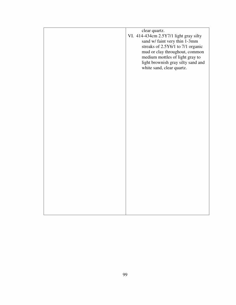
99
clear quartz.
VI. 414-434cm 2.5Y7/1 light gray silty
sand w/ faint very thin 1-3mm
streaks of 2.5Y6/1 to 7/1 organic
mud or clay throughout, common
medium mottles of light gray to
light brownish gray silty sand and
white sand, clear quartz.
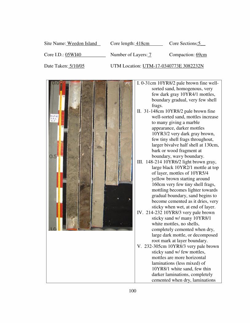
100
Site Name: Weedon Island Core length: 418cm Core Sections:5__
Core I.D.: 05WI40 Number of Layers: 7 Compaction: 69cm
Date Taken: 5/10/05 UTM Location: UTM-17-0340773E 3082232N
I. 0-31cm 10YR8/2 pale brown fine well-
sorted sand, homogenous, very
few dark gray 10YR4/1 mottles,
boundary gradual, very few shell
frags.
II. 31-148cm 10YR8/2 pale brown fine
well-sorted sand, mottles increase
to many giving a marble
appearance, darker mottles
10YR3/2 very dark gray brown,
few tiny shell frags throughout,
larger bivalve half shell at 130cm,
bark or wood fragment at
boundary, wavy boundary.
III. 148-214 10YR6/2 light brown gray,
large black 10YR2/1 mottle at top
of layer, mottles of 10YR5/4
yellow brown starting around
160cm very few tiny shell frags,
mottling becomes lighter towards
gradual boundary, sand begins to
become cemented as it dries, very
sticky when wet, at end of layer.
IV. 214-232 10YR8/3 very pale brown
sticky sand w/ many 10YR8/1
white mottles, no shells,
completely cemented when dry,
large dark mottle, or decomposed
root mark at layer boundary.
V. 232-305cm 10YR8/3 very pale brown
sticky sand w/ few mottles,
mottles are more horizontal
laminations (less mixed) of
10YR8/1 white sand, few thin
darker laminations, completely
cemented when dry, laminations
101
begin to end around 280cm.
VI. 305-318cm 10YR8/1 white sticky
sand w/ medium mottles of
10YR8/3, cemented completely,
abrupt wavy boundary from 316-
220cm.
VII. 318-418cm 10YR8/3 very fine
sticky sand, cemented as dries, w/
few to medium 10YR8/1 white
laminations and mottles.