Embed Size (px)
Citation preview
Anglian Water Ground InvestigationsWhat will I see and hear?

2
IntroductionThis booklet explains what ground and archaeological investigations are and how we will be carrying out these activities as part of the new network of strategic pipelines. You will see us carrying out these investigations at phase 2 of the landowner journey.
Ground investigations mean just that – we investigate the ground by digging or drilling some holes so we can see the conditions below the surface. It is the best way to understand a site.
What are we looking for?
Our investigations will provide a clearer picture of the type of soils, rocks, and groundwater along the
Due to the nature of the work, some of the techniques used will be noisy. We have tried to give an indication as to how much noise each technique creates. The noise level will be influenced by the ground we’re working on, for example, working on hard rock will likely result in higher noise than soft soil.
Is it noisy?
planned pipeline routes. We will also test for strength and stability of the ground and our archaeologists check for any evidence of historical land use.
Who carries out the work?
Our ground investigations will be carried out by approved ground investigations specialist contractors.
Below is a scale to demonstrate everyday noise levels in comparison to the noise of our equipment at a distance of 100 metres away.
Noise levels scale (in decibels dB)
Less noisy Very noisy
22dB
Hair dryer
32dB
Voice – talking
Toilet flushing
42dB
Voice – shouting
Small cement mixer
52dB
Alarm clock
Vacuum cleaner
52dB
Car on motorway
Lawn mower
62dB
Accelerating motorcycle
Chainsaw
Large digger spreading
rubble
72dB
Hand-held pneumatic
breaker
Heavy thunder
Symphony orchestra
82dB
Small aircraft engine
Large church
pipe organ
92dB
Large turbo engine
airplane at take-off
Non-intrusive surveys (above ground)
3
Introduction Non-intrusive surveys (above ground)
Geophysical surveys are non-intrusive techniques. That means they don’t break the surface of the ground and allow us to understand what is going on under the surface. The equipment used for each of the techniques described below is generally self-contained with its own powerpack and can be transported in the back of a van.
Electromagnetic conductivity tests the ability of the ground to conduct an electric current. These detect things like underground metal tanks, utility pipes and potentially contaminated groundwater.
Seismic refraction and reflection uses sound waves to measure changes in soil and rock to understand the ground conditions and structure.
Ground-penetrating radar (GPR) uses radar pulses to create a profile of ground beneath the surface, down to 15 metres.
A magnetometer is used to measure changes in the strength and direction of a magnetic field to detect buried objects or deposits.
Microgravity is used to detect underground cavities or changes in ground density, flagging up where the ground is potentially hazardous.
Resistivity uses a low voltage electric current to record changes in resistance between steel pegs and can detect and map underground features and patterns.
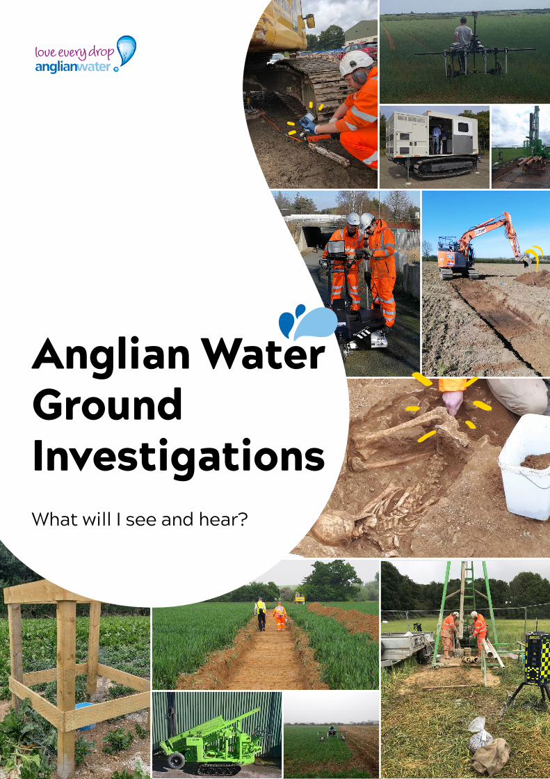
Geophysical surveysOur teams will use a magnetometer. This is a machine that records changes in the magnetic resistance of the ground.
Some archaeological remains e.g. pottery, have differing magnetic resistance. A magnetometer can pick up this resistance compared to the surrounding ground.
We may need to temporarily mark our route using small wooden pegs/canes or flags. These are usually in place for a few days although this can vary depending on the size of the area.
Ground-penetrating radar (GPR)Image courtesy of Socotec
4
Techniques we will useOur teams will let you know which technique we intend to use, and why.
Each of the techniques are used for a different purpose, and none can give a complete picture of what archaeological remains might be present below the ground. For this reason, we use a combination of intrusive and non-intrusive surveys. Deciding which method we will use will depend on a number of things. These include the type of geology, land use, what archaeology we expect in the area and county archaeologist requirements.
Walkover survey/site visitsWe use this technique to assess land on foot as a 'walkover' survey. The land will be accessed on foot (vehicles will be parked at pre-agreed stopping points) and our teams will take photographs and make notes.
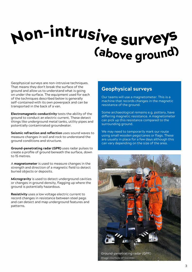
Hand-held surveysSometimes for larger, wider areas the land might be suitable for a push or pull-along cart. The cart will be pulled by hand, although it may be pulled by a quad bike. Our teams will take care not to damage the ground.
Pull-along cart systemSource: Magnitude Surveys 2020
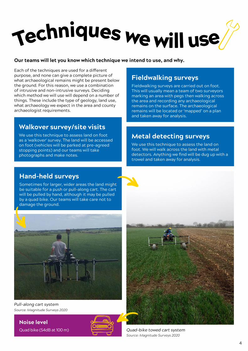
Noise level Quad bike (54dB at 100 m)
Fieldwalking surveysFieldwalking surveys are carried out on foot. This will usually mean a team of two surveyors marking an area with pegs then walking across the area and recording any archaeological remains on the surface. The archaeological remains will be located or ‘mapped’ on a plan and taken away for analysis.
Metal detecting surveysWe use this technique to assess the land on foot. We will walk across the land with metal detectors. Anything we find will be dug up with a trowel and taken away for analysis.
Quad-bike towed cart systemSource: Magnitude Surveys 2020
Intrusive surveys (below ground)
5
Techniques we will use Intrusive surveys (below ground)
The following is a summary of the main techniques we use, with examples of what you will typically see on a site.
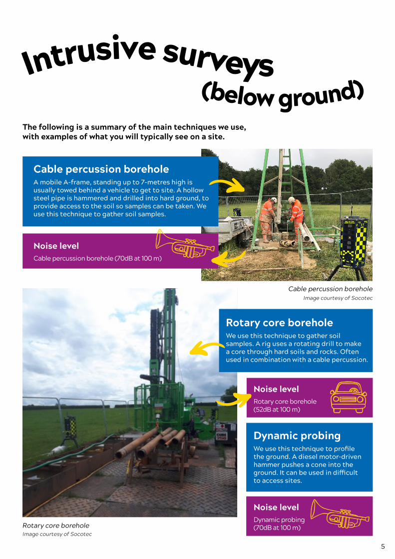
Cable percussion borehole A mobile A-frame, standing up to 7-metres high is usually towed behind a vehicle to get to site. A hollow steel pipe is hammered and drilled into hard ground, to provide access to the soil so samples can be taken. We use this technique to gather soil samples.
Noise level Cable percussion borehole (70dB at 100 m)
Cable percussion boreholeImage courtesy of Socotec
Rotary core boreholeImage courtesy of Socotec
Rotary core borehole We use this technique to gather soil samples. A rig uses a rotating drill to make a core through hard soils and rocks. Often used in combination with a cable percussion.
Noise level Rotary core borehole (52dB at 100 m)
Dynamic probing We use this technique to profile the ground. A diesel motor-driven hammer pushes a cone into the ground. It can be used in difficult to access sites.
Noise level Dynamic probing (70dB at 100 m)
6
Cone penetration testing truck Image courtesy of Socotec
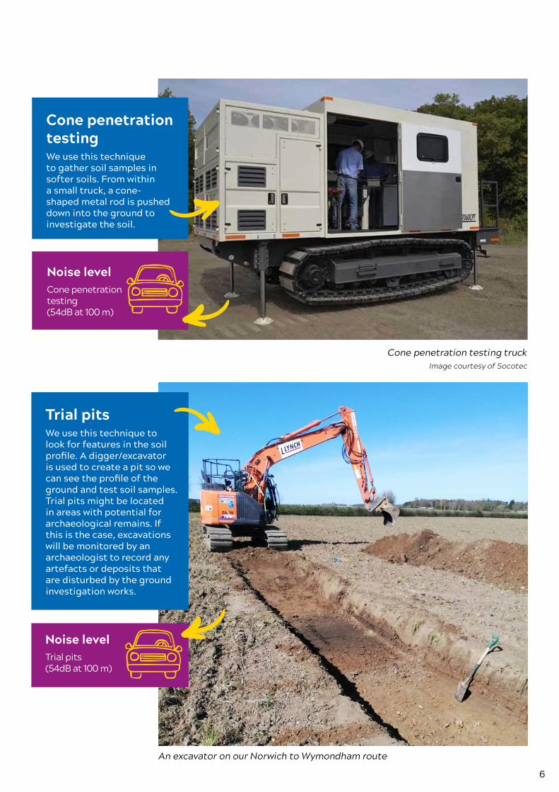
Cone penetration testing We use this technique to gather soil samples in softer soils. From within a small truck, a cone-shaped metal rod is pushed down into the ground to investigate the soil.
Noise level Cone penetration testing (54dB at 100 m)
An excavator on our Norwich to Wymondham route
Trial pits We use this technique to look for features in the soil profile. A digger/excavator is used to create a pit so we can see the profile of the ground and test soil samples. Trial pits might be located in areas with potential for archaeological remains. If this is the case, excavations will be monitored by an archaeologist to record any artefacts or deposits that are disturbed by the ground investigation works.
Noise level Trial pits (54dB at 100 m)
7
Window sampler rigImage courtesy of Socotec
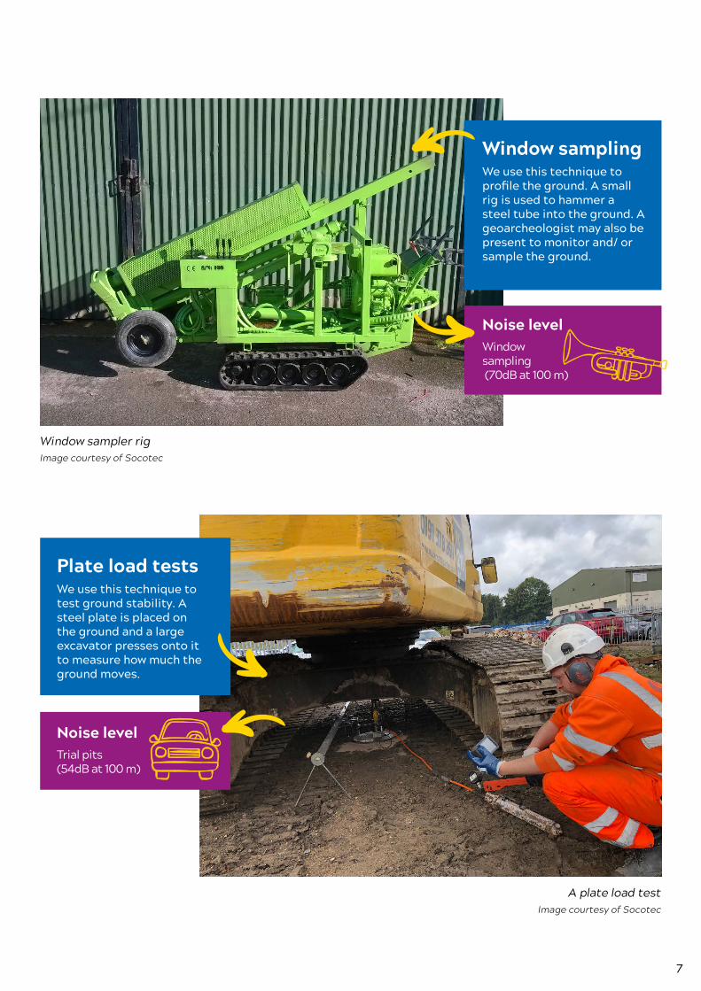
Window sampling We use this technique to profile the ground. A small rig is used to hammer a steel tube into the ground. A geoarcheologist may also be present to monitor and/ or sample the ground.
Noise level Window sampling (70dB at 100 m)
A plate load testImage courtesy of Socotec
Plate load tests We use this technique to test ground stability. A steel plate is placed on the ground and a large excavator presses onto it to measure how much the ground moves.
Noise level Trial pits (54dB at 100 m)
8
Archaeological investigationsOur archaeological investigations will check to see if our work is likely to disturb any buried archaeological remains such as evidence of human activity in the past. For example, pottery, stone tools and changes to the land such as pits and ditches.
What are we looking for?
Our teams will check the significance of any archaeological remains and, if found, will work out the best way to preserve or excavate them.
What happens if we find artefacts?
All finds (or artefacts) remain the property of the landowner. A transfer of ownership form will be issued once any finds need to be archived.
Iron Age skeletons found
at archaeological sites near
Navenby, 2020
Finds will be taken away for cleaning, recording and analysis. All finds remain the property of the landowner. However, the normal process is that ownership is transferred from the landowner to the local museum or archive store through completion of a transfer of ownership form.
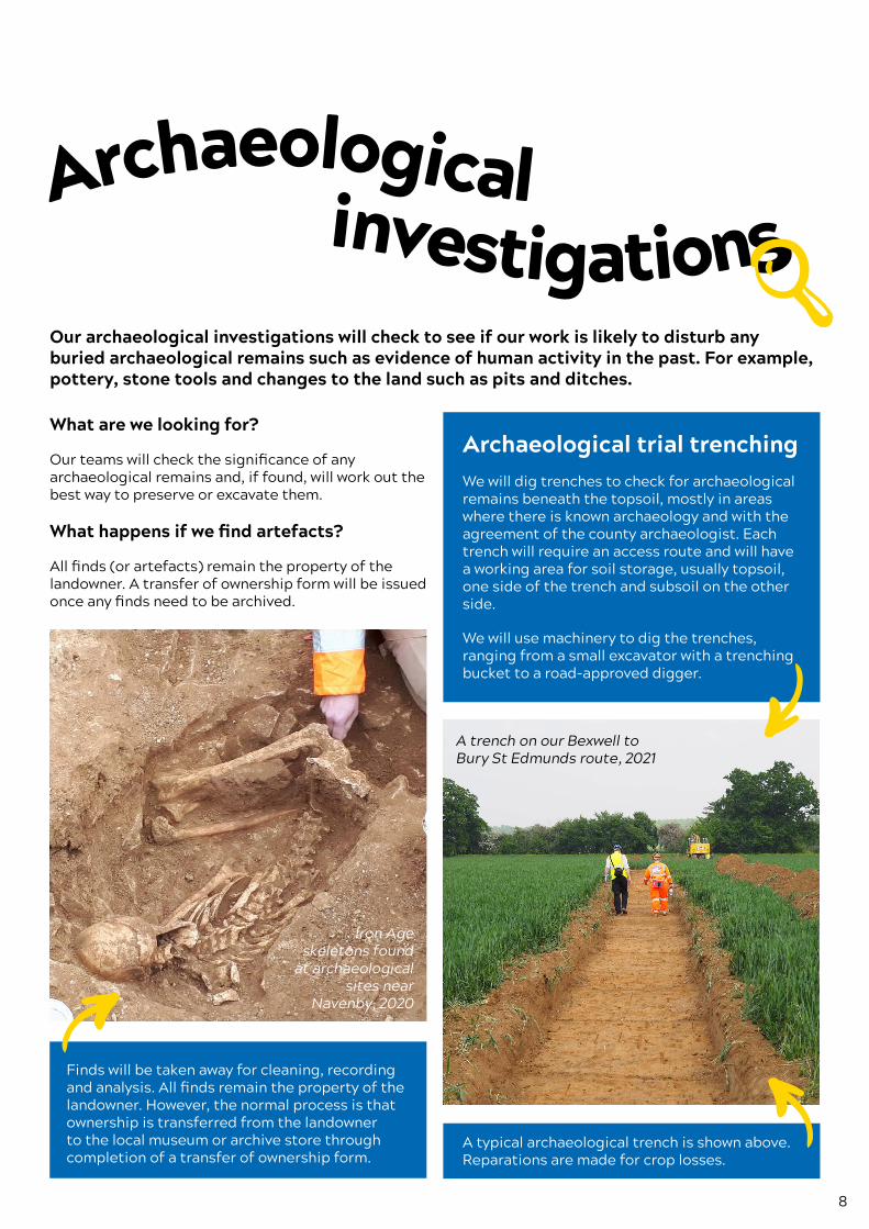
Archaeological trial trenchingWe will dig trenches to check for archaeological remains beneath the topsoil, mostly in areas where there is known archaeology and with the agreement of the county archaeologist. Each trench will require an access route and will have a working area for soil storage, usually topsoil, one side of the trench and subsoil on the other side.
We will use machinery to dig the trenches, ranging from a small excavator with a trenching bucket to a road-approved digger.
A trench on our Bexwell to Bury St Edmunds route, 2021
A typical archaeological trench is shown above. Reparations are made for crop losses.
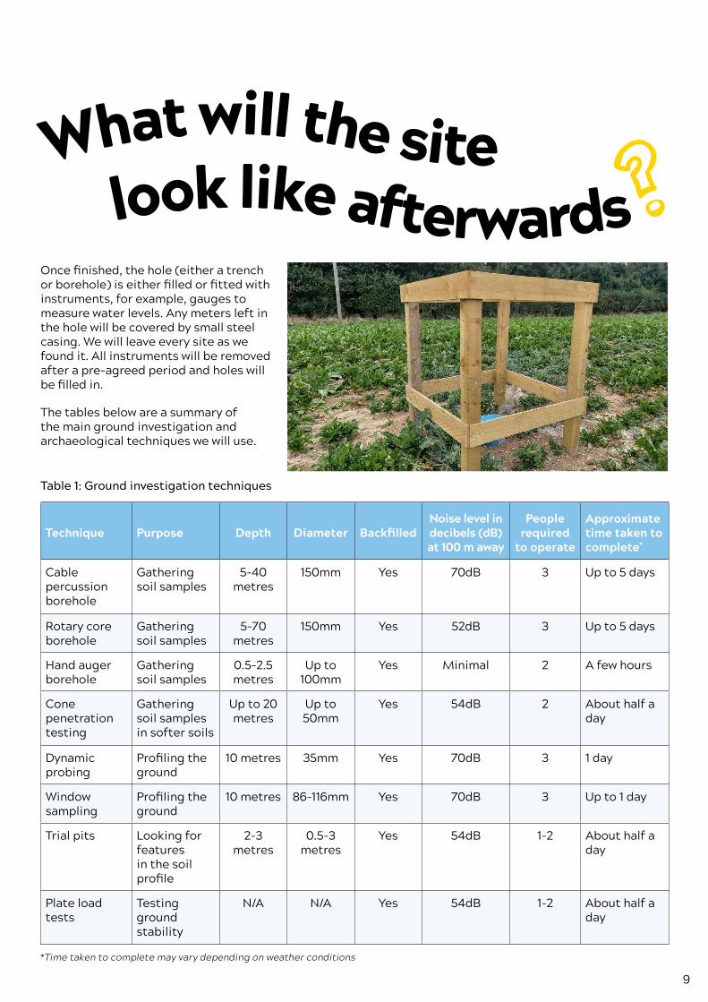
What will the site look like afterwards
9
Archaeological investigations
What will the site look like afterwards
Once finished, the hole (either a trench or borehole) is either filled or fitted with instruments, for example, gauges to measure water levels. Any meters left in the hole will be covered by small steel casing. We will leave every site as we found it. All instruments will be removed after a pre-agreed period and holes will be filled in.
The tables below are a summary of the main ground investigation and archaeological techniques we will use.
Table 1: Ground investigation techniques
Technique Purpose Depth Diameter BackfilledNoise level in decibels (dB) at 100 m away
People required
to operate
Approximate time taken to complete*
Cable percussion borehole
Gathering soil samples
5-40 metres
150mm Yes 70dB 3 Up to 5 days
Rotary core borehole
Gathering soil samples
5-70 metres
150mm Yes 52dB 3 Up to 5 days
Hand auger borehole
Gathering soil samples
0.5-2.5 metres
Up to 100mm
Yes Minimal 2 A few hours
Cone penetration testing
Gathering soil samples in softer soils
Up to 20 metres
Up to 50mm
Yes 54dB 2 About half a day
Dynamic probing
Profiling the ground
10 metres 35mm Yes 70dB 3 1 day
Window sampling
Profiling the ground
10 metres 86-116mm Yes 70dB 3 Up to 1 day
Trial pits Looking for features in the soil profile
2-3 metres
0.5-3 metres
Yes 54dB 1-2 About half a day
Plate load tests
Testing ground stability
N/A N/A Yes 54dB 1-2 About half a day
*Time taken to complete may vary depending on weather conditions
10
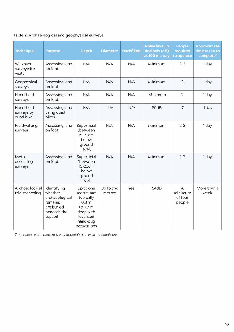
Table 2: Archaeological and geophysical surveys
Technique Purpose Depth Diameter BackfilledNoise level in decibels (dB) at 100 m away
People required
to operate
Approximate time taken to
complete*
Walkover survey/site visits
Assessing land on foot
N/A N/A N/A Minimum 2-3 1 day
Geophysical surveys
Assessing land on foot
N/A N/A N/A Minimum 2 1 day
Hand-held surveys
Assessing land on foot
N/A N/A N/A Minimum 2 1 day
Hand-held surveys by quad bike
Assessing land using quad bikes
N/A N/A N/A 50dB 2 1 day
Fieldwalking surveys
Assessing land on foot
Superficial (between 15-23cm
below ground level)
N/A N/A Minimum 2-3 1 day
Metal detecting surveys
Assessing land on foot
Superficial (between 15-23cm
below ground level)
N/A N/A Minimum 2-3 1 day
Archaeological trial trenching
Identifying whether archaeological remains are buried beneath the topsoil
Up to one metre, but
typically 0.3 m
to 0.7 m deep with localised hand-dug
excavations
Up to two metres
Yes 54dB A minimum
of four people
More than a week
*Time taken to complete may vary depending on weather conditions

11
Contact details for land access, surveys and pipeline enquiriesEmail: [email protected]
Phone: (+44) 02087 743928 for land in the north(+44) 02920 353330 for land in the southFor more landowner information and an explanation of these phases, please visit anglianwater.co.uk/about-us/our-strategies-and-plans/new-water-pipelines/landowner-journey/
Or alternatively, please visit www.anglianwater.co.uk/compliments