Embed Size (px)
Citation preview
A SIMULATION-AS-A-SERVICE FRAMEWORK FACILITATING WEBGIS BASED
INSTALLATION PLANNING
Z. Zheng a , Z.Y. Chang, Y.F. Fei a
a Dept. of Planning, Beijing Special Civil Engineering Design and Research Institute, Beijing, P.R.C. - [email protected]
Commission IV, WG IV/4
KEY WORDS: Web GIS, Multi-Agent Systems, Simulation-as-a-Service, Framework Design, Installation Planning
ABSTRACT:
Installation Planning is constrained by both natural and social conditions, especially for spatially sparse but functionally connected
facilities. Simulation is important for proper deploy in space and configuration in function of facilities to make them a cohesive and
supportive system to meet users’ operation needs. Based on requirement analysis, we propose a framework to combine GIS and
Agent simulation to overcome the shortness in temporal analysis and task simulation of traditional GIS. In this framework, Agent
based simulation runs as a service on the server, exposes basic simulation functions, such as scenario configuration, simulation
control, and simulation data retrieval to installation planners. At the same time, the simulation service is able to utilize various kinds
of geoprocessing services in Agents’ process logic to make sophisticated spatial inferences and analysis. This simulation-as-a-service
framework has many potential benefits, such as easy-to-use, on-demand, shared understanding, and boosted performances. At the
end, we present a preliminary implement of this concept using ArcGIS javascript api 4.0 and ArcGIS for server, showing how trip
planning and driving can be carried out by agents.
1. INTRODUCTION
In installation planning, it is essential to make sure the location
and functional configuration of each facility in it meet the users’
needs effectively and efficiently, especially when a number of
functionally interrelated facilities should be dispersed into a
large area, where the costs of transportations would be high.
As a tool for geographic information management, analysis and
decision support, GIS plays an important role in resolve
complex installation planning and management problems
(Fraile, 2016). Widely used as it is, GIS based planning has
limited capability in users’ behavior analysis, which is
necessary for optimizing configuration of installations.
In recent years, Web GIS moves into maturity, with its easy-to-
use, easy-to-share and highly interactivity, it is widely used as a
method to communicate with users, and collect users’ opinions
about the installation plan, such as reservoir siting (Walsh,
2015), risk management (Aye, 2016), environmental impact
assessment (Wanderer, 2015), emergency management (Wu,
2013), shield tunnel construction planning (Li, 2013), and
landslide disaster information publishing (Yu, 2012). Temporal-
spatial pattern researches based on Web GIS are covered
frequently nowadays too (Martino, 2016).
On the other hand, shortly after the birth of Web, WBS started
to emerge (Byrne,2010). In 1995, first web-front end simulation
run as Common Gateway Interface was created. In 1998 first
conference dedicated to Web based modelling and simulation
was held. From its birth, web based simulation has gained
continuously attention and active research. With the
development of new technologies, such as Service Oriented
Architecture, Web 2.0 and semantic web, web based simulation
is getting a broad development opportunity.
In this paper, we try to focus on the spatial configuration and
functional configuration problem of installation planning,
propose a simulation service framework, and based on this
framework, implement some useful functions. We hope to
exemplify the usefulness and feasibility of our concept, and
accumulate experiences for following works.
2. RELATED TECHNOLOGIES
2.1 Web based simulation
Web based simulation (WBS) can be defined as the use of
resources and technologies offered by the World-Wide-Web for
interaction with client and server modelling and simulation
tools (Byrne, 2010). WBS uses browser to display information
and receive user input. It is compatible and well adapted to
heterogeneous and distributed environment, making interaction
and cooperating between software across different platforms,
different operating systems, and different network environments
possible. WBS can share situations among many participants,
promoting common understanding of problems, it is an
important supporting technology for computer supported
cooperative work (CSCW).
WBS has a lot of advantages, such as easy to use, convenient
for cooperating, flexible deployment and authorization, strong
compatibility, and cross-platform. It has induced interests from
domains like education & training (Cant, 2014; Granlund, 2000;
Beam, 2006), design and production (Li, 2013; Wang, 2012),
and military modelling and simulations (Page, 2000). There are
also some works trying to incorporating GIS with WBS in
ecology (Adeva, 2012) and agriculture planning (Rao, 2007).
WBS is especially attractive in its capability for resource
integration. A lot of works has been done in this area, including:
implementing computation models as web services (Johansson,
2003), packaging DEVS resources into web services to
promoting interactions, publishing general simulation models as
services to support discrete event simulations (Gyimesi, 2008),
The International Archives of the Photogrammetry, Remote Sensing and Spatial Information Sciences, Volume XLII-2/W7, 2017 ISPRS Geospatial Week 2017, 18–22 September 2017, Wuhan, China
This contribution has been peer-reviewed. https://doi.org/10.5194/isprs-archives-XLII-2-W7-193-2017 | © Authors 2017. CC BY 4.0 License.
193

and organizing computation services for task analysis (Wang,
2010; Senin, 2003).
The enabling technologies (Byrne, 2010) of WBS can be
classified as middleware, database management system, web
language & tools, and simulation tools and libraries. As the
result of the openness of WBS and rapid development of
technologies, a great many of architectures and technologies,
such as Web Service, HLA, Semantic Web, EJB, CORBA, has
been developed and used in WBS. WBS tools such as Insight
Maker (Fortmann-Roe, 2014), which supports system dynamics
and agent based simulation, and JSIM (Miller, 2000), which is
based on component technology has been proposed by
researchers.
2.2 Web GIS
Web GIS was first introduced to realise online accesses to
geographic information databases. One representative project is
Alexandria project. Users can access, browse and download
maps, orthophotos, SPOT images and Landsat Images by
remote web clients. After the Alexandria project, Terraserver
from Microsoft, EOS data gateway from NASA, and
MapConnect from Australia has put into use. Accessing
geographic data through web has become usual practices. By
the late 1990s, distributed and interoperable processing
architectures based on Internet helped to improve geographic
information integration. Web GIS got the capability to support
teams in different places with information sharing and
cooperating. In the 2000s, geographic information exchange and
storage was promoted with several geographic information
specific markup languages such as GML and KML. In recent
years, developers and researchers from outside of the traditional
geographic industry made great contributions to the
development of Web GIS, new concepts such as service-
oriented architecture, collaborative applications, and loosely
coupled structure, has promoted many new types of Web GIS
applications. (Raper, 2009)
Interaction and cooperation are the most prominent features of
Web GIS. A lot of researches have adopted Web GIS in the
solutions of their problems. For example, in the risk
management area, Aye et al. proposed a collaborative Web GIS
framework to improve the intra-department collaboration (Aye,
2016); in the construction planning area, Walsh et al. designed a
reservoir siting tool to interact with publics for screening and
evaluation.
Now, developing of Web GIS is backed by a great many
specifications. Open Geospatial Consortium released
specifications for network transformation of geographic
information (such as WMS, WFS and WCS), specifications for
data format (such as SFS, GML and KML), and specifications
for data search (such as OGC-CSW and OGC-WPS). These
specifications set common standards for Web GIS development,
promised the interoperability of Web GIS applications. There
are many open source software and libraries for Web GIS
application, which roughly divided into 3 categories: spatial
data storage (such as PostGIS, MySQL and Spaital), spatial data
publishing and sharing (such as MapServer, GeoServer,
GoogleMaps and GoogleEarth), and geoprocessing and spatial
analysis (such as 52°North WPS、PyWPS、GeoServer and
degreeWPS). All these technologies provided a steady base for
Web GIS application developing. (Swain, 2015)
3. REQUIREMENT ANALYSIS
Requirement analysis is the first step of framework designing.
The goal of this framework is to support the analysis of spatial
configuration and functional configuration of spatially dispersed
and functionally related facilities. This framework will
incorporate the power of simulation and GIS to help users
answer what-if questions about their plans, support them
making better decisions.
Requirements can be divided into functional requirements and
system requirements. Functional requirements are the characters
and services the system should provide. System requirements
state the technology constraints that the system should respect.
We consider these requirements together, and listed them as
follows:
1. The system should have sufficient capability to represent
facility users’ activity. This means our system should be capable
of setting a virtual environment to host the facilities of the
installation in planning and their users, so we can simulate
typical activities of the users of these facilities, to see what
aspects of the activities will be affected and how will these
aspects be affected by the installation configuration.
The system should have sufficient capability to model the
facility users’ tasks, the physical constraints and logical
constraints of these tasks. It should also have sufficient
capability to model the interactions between facility user and
the geographic environment, including spatial related
deductions and decisions, such as route planning and moving
along the route.
2. The system should provide installation planners with
functions to control the simulation. Installation planners should
be able to setup the simulation scenario, start, stop and monitor
the simulation.
3. The system should have good availability. The negative
effects of system maintenance, such as model updating, UI
upgrading, and functional extension, should be reduced to the
minimum extent.
4. The system should simulate a large area. The extent of the
simulation area should be large enough to match the planning
area, typically, several hundred kilometres long and several
hundred kilometres width.
5. The system should be extensible. Simulation model should
reflect installation planner’s needs, and can be added, modified
and deleted easily.
4. FRAMEWORK DESIGN
4.1 Framework Architecture
In order to realise the requirements listed in the previous
section, we adopt a Web GIS based architecture. Facility users’
activity simulation is designed as a service running separately
on the backend server, this service can be seen as a resource
which can be used later in other places. The benefit of this is
that all resources, (including geographic information and
simulation) can be integrated and managed with mature web
technologies, providing good interactivity and availability.
The architecture of the framework is displayed in Figure. 1. The
system is composed of two loosely coupled modules, which is,
the geographic service and the simulation service. Both services
The International Archives of the Photogrammetry, Remote Sensing and Spatial Information Sciences, Volume XLII-2/W7, 2017 ISPRS Geospatial Week 2017, 18–22 September 2017, Wuhan, China
This contribution has been peer-reviewed. https://doi.org/10.5194/isprs-archives-XLII-2-W7-193-2017 | © Authors 2017. CC BY 4.0 License.
194
can be consumed by a remote installation planner through a web
browser. The geographic service provides installation planner
with maps and spatial analysis functions; The simulation service
provides installation planner with simulation scenario setup,
simulation control, and monitor functions. The simulation
models can also use geoprocessing services provided by
geographic service in their business logic to make space related
deductions and decisions.
Task Data Source
Web Browser
Map Service Analyse Service Simulation Service
GIS
Spatial Data Source
Geo-processing Services
Simulation Engine
Agents
Spatial Db Task Db
Figure 1. Framework Architecture
4.2 Implementing Technologies
The implementation of the framework is divided into two parts:
the server side and the client side.
4.2.1 Server side
There are essentially 3 kinds of services running in the server
side, which is, map service, geo-analysis service, and simulation
service. For map service, there are many open source projects
provides good enough functions for map rendering, such as
Mapserver and Geoserver, nearly all of them is compatible with
OGC’s WMS specification and WMTS specification. This
framework adopts WMS and WMTS as map service
specification, so it’s free to choose map server as long as it
supports these specifications. Geo-analysis service is based on
geoprocessing services. Geoprocessing service can be built on
OGC’s Web Processing Service, which is now supported by
most open source geoprocessing software/libraries, such as
degreeWPS, pyWPS, and 52°North WPS. Complex geo-
analysis can be orchestrated by simple geo-process through
BPEL specification and other ways (Weiser, 2007). Spatial data
storage can be provided by several open source spatial database,
among them, PostgreSQL with PostGIS extension is most
widely used.
While open source software/libraries are capable of providing a
solid foundation for the architecture depicted in Figure 1. Most
modern commercial GIS are capable of providing both map
service and geoprocessing service, and it is usually easier to use
than open source tools. As a pilot study, we choose ArcGIS for
server as the supplier for both map service and geoprocessing
service to focus on the simulation service concept. The map
service of ArcGIS for server is used to display base map. Map
can be prepared and published from ArcGIS Desktop. Once
published, the map can be consumed over the web. Geospatial
query and analysis can be supported by Feature Services,
Geometry Services, Network Analysis Service and
Geoprocessing Services. Models can issue a task to these
services and get responses in specified formats from them.
In order to evaluate the effects of installation plan on real users,
it is important to reflect the autonomous behaviors of facility
users. Agent-based simulation paradigm is adopted to meet this
need. As stated by (Brown, 2005), integrating GIS with agent-
based simulation, need to address 4 basic relationships, which
are identity, causal, temporal and topological relationship. In
our architecture, a service based approach is adopted. Agent
platform is responsible for time management and task schedule,
spatial query and analysis is realized through geoprocessing
service.
Popular agent platforms in urban and architecture research
include Swarm, Mason, Repast, StarLogo, Netlogo and so on
(Chen, 2012). Among them, Mason has a separate design for UI
and model scheduling system, supports intrinsic data types for
continuous and discrete spatial structures and network data
structure for relations, is more suitable for our architecture.So
we choose Mason as the simulation engine for the simulation
service.
4.2.2 Client side
At the client end, browser is used to consume geographic
service and simulation service, and display maps and simulation
situations. The inputs for simulation scenario setup, simulation
control are also read from installation planners.
Javascript is used as the develop language of the browser-end
functions. Supporting API can be Openlayers or ArcGIS
Javascript API. As we chose ArcGIS for server to provide map
service, we adopt ArcGIS Javascript API as the client side
developing language just for convenience.
4.3 COMPOSING SIMULATION SERVICE
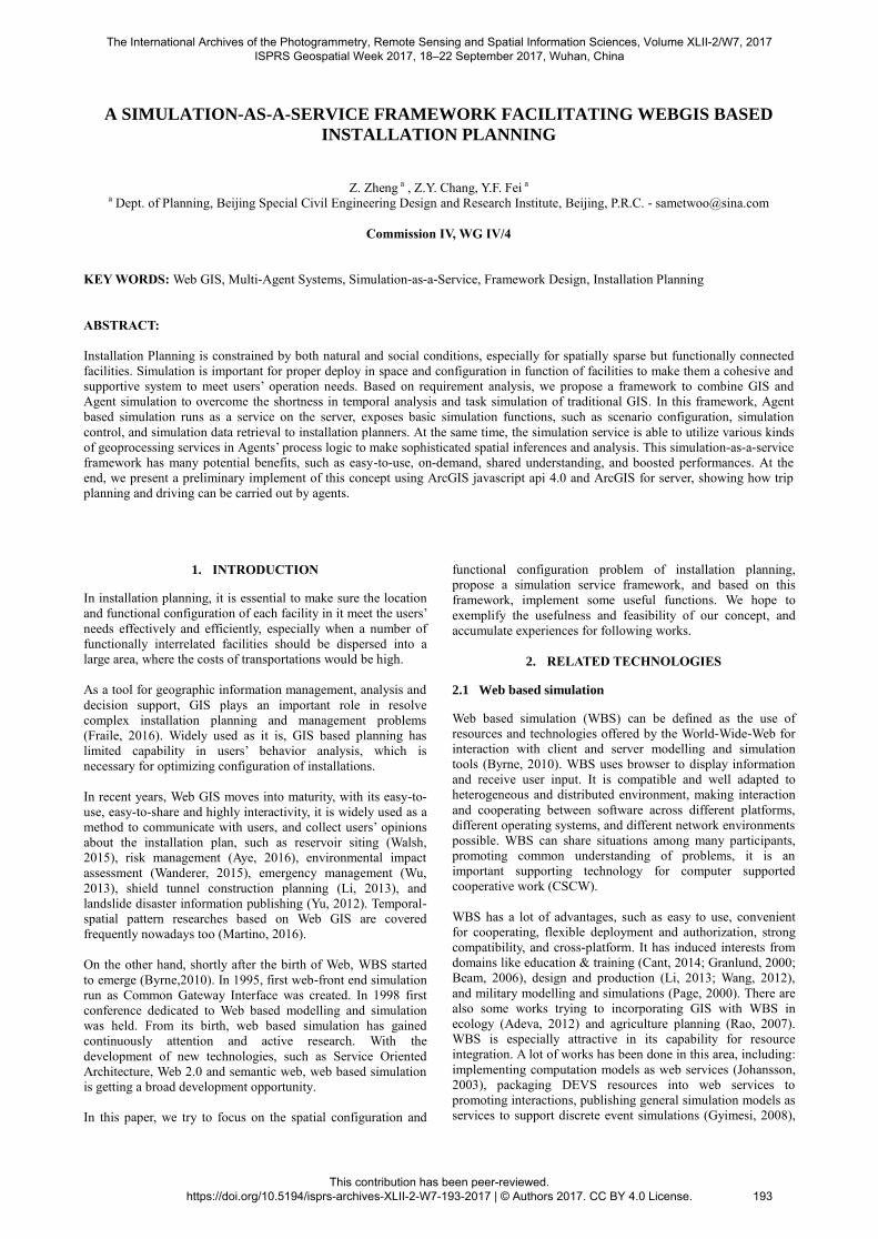
4.3.1 Simulation service in detail
Simulation service provides users with scenario editing,
simulation control, and simulation monitoring functions in the
form of EJB running in Glassfish application server. Users
interact with simulation service through RESTful APIs, and
receive real-time simulation status through WebSocket protocol.
The simulation service EJB encapsulates Mason engine to
actually carry out simulations.
It is vital for agents to make spatial related deliberations when
they are used to simulate human behavior to assess installation
plans. Geoprocessing services are used to meet this need. A
geoprocessing service is a stateless calculation service that can
provide operations for agent to make spatial query and analysis.
These operations will help agents make better decisions in a
complex topographic environment. The decision is based on the
comprehensive perception involving spatial, social, and task
conditions, these conditions are kept in the Environment
Description data structure managed by the mason engine. The
Environment Description is composed of a general relation
network, which stores all kinds of relationships except task
assignment relation (see section 4.3.2), a task assignment
network, which describes the task assignment for every agent,
and a location grid, which maintains the spatial relationship
between agents. The Environment Description is updated after
each action carried out by agents, to reflect the common
knowledge shared by all agents. Agents do their tasks according
to the Environment Description and data stored in the task
database. This design will facilitate modeling and simulation for
collaborative complex tasks.
The International Archives of the Photogrammetry, Remote Sensing and Spatial Information Sciences, Volume XLII-2/W7, 2017 ISPRS Geospatial Week 2017, 18–22 September 2017, Wuhan, China
This contribution has been peer-reviewed. https://doi.org/10.5194/isprs-archives-XLII-2-W7-193-2017 | © Authors 2017. CC BY 4.0 License.
195
EJB on Glassfish
Geoprocessing ServiceGeoprocessing Service
Mason
Task Assignment
Network
General Relation Network
Location Grid
Agents
Task Schedule
SpatialDeliberation
Environmental Description
Scenario Setup
Start Simulation
Stop Simulation
State Publish
BrowserBrowser
Task DB
Figure 2. Simulation Service in Detail
4.3.2 Modelling in the simulation service
The model system of the simulation service focuses on the
behavior of facility users.All models can be categorized into 3
types: Entity, Behavior, and Relation. Entity is the abstract class
of every perceivable objects, including facilities, roads, hills,
and users of facilities. Relation is the abstract class of all
interactions and links between entities. Behavior is an
independent model class. Behavior models can be “attached” to
some kind of entity, giving it the capability to change the states
of entities both of itself and others.
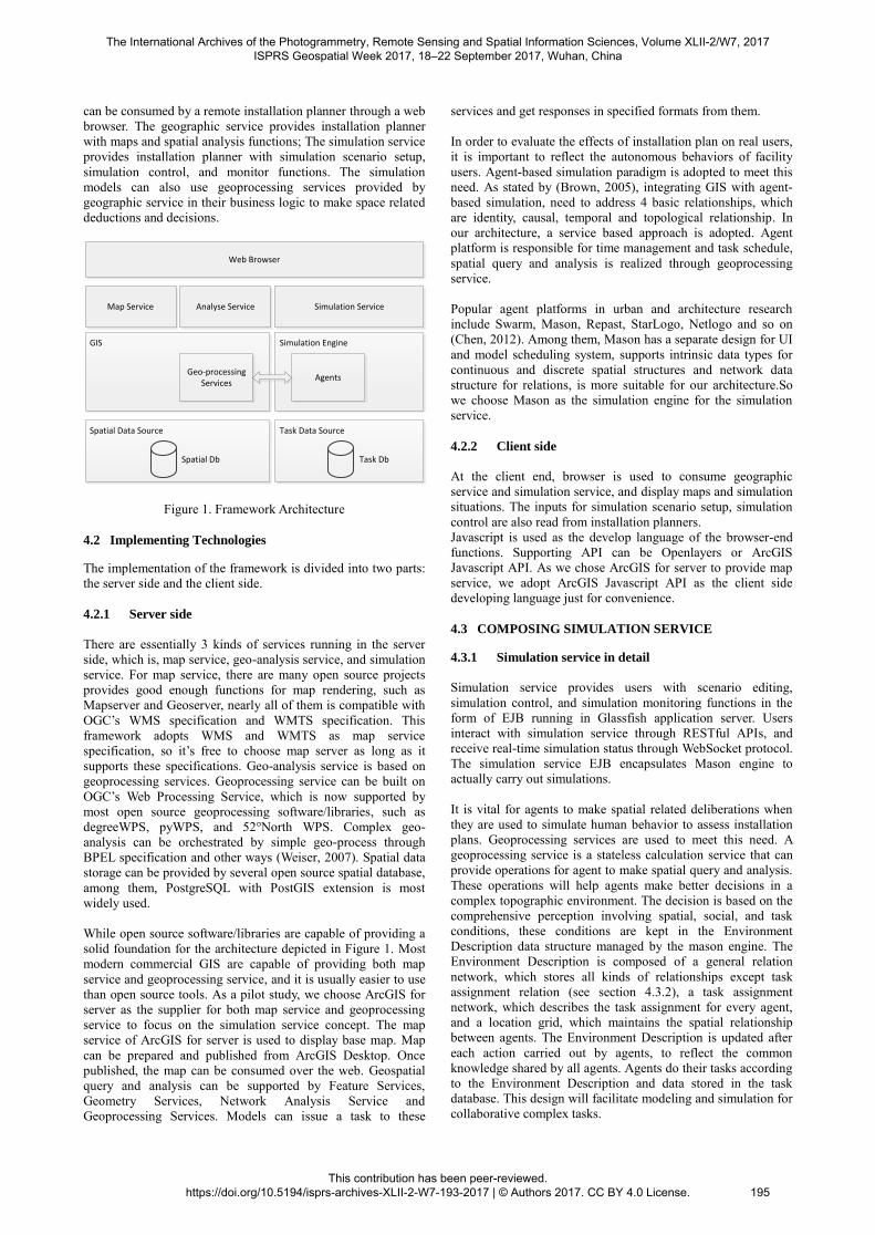
Entity model can be subclassified into Agent, Task, and Passive
Object (Figure. 3). Agent can attach behavior models to
simulate real behavior of facility users, Passive Object (PO)
cannot attach behavior. Task is a special kind of Entity, it can be
seen as the script of the Agent, the behavior model can read this
script, and carry out actions accordingly.
Entity
Agent Task Passive Object
Driver Engineer TaskManeuver TaskPrepare Truck Warehouse
Figure 3. A Part of Entity Meta Model
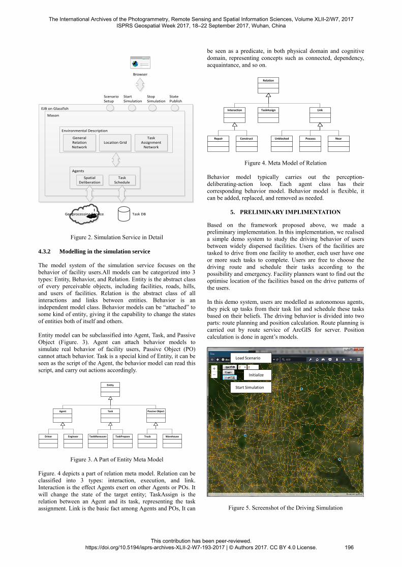
Figure. 4 depicts a part of relation meta model. Relation can be
classified into 3 types: interaction, execution, and link.
Interaction is the effect Agents exert on other Agents or POs. It
will change the state of the target entity; TaskAssign is the
relation between an Agent and its task, representing the task
assignment. Link is the basic fact among Agents and POs, It can
be seen as a predicate, in both physical domain and cognitive
domain, representing concepts such as connected, dependency,
acquaintance, and so on.
Relation
Interaction TaskAssign Link
Repair Construct Possess NearUnblocked
Figure 4. Meta Model of Relation
Behavior model typically carries out the perception-
deliberating-action loop. Each agent class has their
corresponding behavior model. Behavior model is flexible, it
can be added, replaced, and removed as needed.
5. PRELIMINARY IMPLIMENTATION
Based on the framework proposed above, we made a
preliminary implementation. In this implementation, we realised
a simple demo system to study the driving behavior of users
between widely dispersed facilities. Users of the facilities are
tasked to drive from one facility to another, each user have one
or more such tasks to complete. Users are free to choose the
driving route and schedule their tasks according to the
possibility and emergency. Facility planners want to find out the
optimise location of the facilities based on the drive patterns of
the users.
In this demo system, users are modelled as autonomous agents,
they pick up tasks from their task list and schedule these tasks
based on their beliefs. The driving behavior is divided into two
parts: route planning and position calculation. Route planning is
carried out by route service of ArcGIS for server. Position
calculation is done in agent’s models.
Figure 5. Screenshot of the Driving Simulation
Load Scenario
Start Simulation
Initialize
The International Archives of the Photogrammetry, Remote Sensing and Spatial Information Sciences, Volume XLII-2/W7, 2017 ISPRS Geospatial Week 2017, 18–22 September 2017, Wuhan, China
This contribution has been peer-reviewed. https://doi.org/10.5194/isprs-archives-XLII-2-W7-193-2017 | © Authors 2017. CC BY 4.0 License.
196
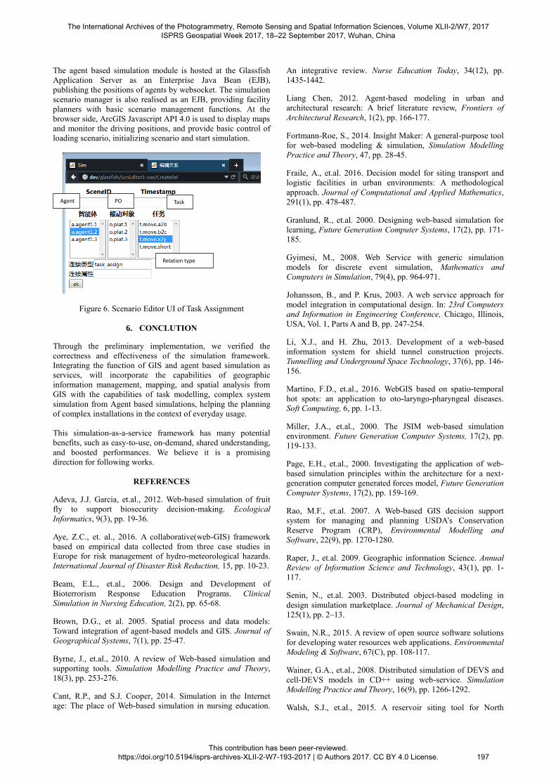
The agent based simulation module is hosted at the Glassfish
Application Server as an Enterprise Java Bean (EJB),
publishing the positions of agents by websocket. The simulation
scenario manager is also realised as an EJB, providing facility
planners with basic scenario management functions. At the
browser side, ArcGIS Javascript API 4.0 is used to display maps
and monitor the driving positions, and provide basic control of
loading scenario, initializing scenario and start simulation.
Figure 6. Scenario Editor UI of Task Assignment
6. CONCLUTION
Through the preliminary implementation, we verified the
correctness and effectiveness of the simulation framework.
Integrating the function of GIS and agent based simulation as
services, will incorporate the capabilities of geographic
information management, mapping, and spatial analysis from
GIS with the capabilities of task modelling, complex system
simulation from Agent based simulations, helping the planning
of complex installations in the context of everyday usage.
This simulation-as-a-service framework has many potential
benefits, such as easy-to-use, on-demand, shared understanding,
and boosted performances. We believe it is a promising
direction for following works.
REFERENCES
Adeva, J.J. Garcia, et.al., 2012. Web-based simulation of fruit
fly to support biosecurity decision-making. Ecological
Informatics, 9(3), pp. 19-36.
Aye, Z.C., et. al., 2016. A collaborative(web-GIS) framework
based on empirical data collected from three case studies in
Europe for risk management of hydro-meteorological hazards.
International Journal of Disaster Risk Reduction, 15, pp. 10-23.
Beam, E.L., et.al., 2006. Design and Development of
Bioterrorism Response Education Programs. Clinical
Simulation in Nursing Education, 2(2), pp. 65-68.
Brown, D.G., et al. 2005. Spatial process and data models:
Toward integration of agent-based models and GIS. Journal of
Geographical Systems, 7(1), pp. 25-47.
Byrne, J., et.al., 2010. A review of Web-based simulation and
supporting tools. Simulation Modelling Practice and Theory,
18(3), pp. 253-276.
Cant, R.P., and S.J. Cooper, 2014. Simulation in the Internet
age: The place of Web-based simulation in nursing education.
An integrative review. Nurse Education Today, 34(12), pp.
1435-1442.
Liang Chen, 2012. Agent-based modeling in urban and
architectural research: A brief literature review, Frontiers of
Architectural Research, 1(2), pp. 166-177.
Fortmann-Roe, S., 2014. Insight Maker: A general-purpose tool
for web-based modeling & simulation, Simulation Modelling
Practice and Theory, 47, pp. 28-45.
Fraile, A., et.al. 2016. Decision model for siting transport and
logistic facilities in urban environments: A methodological
approach. Journal of Computational and Applied Mathematics,
291(1), pp. 478-487.
Granlund, R., et.al. 2000. Designing web-based simulation for
learning, Future Generation Computer Systems, 17(2), pp. 171-
185.
Gyimesi, M., 2008. Web Service with generic simulation
models for discrete event simulation, Mathematics and
Computers in Simulation, 79(4), pp. 964-971.
Johansson, B., and P. Krus, 2003. A web service approach for
model integration in computational design. In: 23rd Computers
and Information in Engineering Conference, Chicago, Illinois,
USA, Vol. 1, Parts A and B, pp. 247-254.
Li, X.J., and H. Zhu, 2013. Development of a web-based
information system for shield tunnel construction projects.
Tunnelling and Underground Space Technology, 37(6), pp. 146-
156.
Martino, F.D., et.al., 2016. WebGIS based on spatio-temporal
hot spots: an application to oto-laryngo-pharyngeal diseases.
Soft Computing, 6, pp. 1-13.
Miller, J.A., et.al., 2000. The JSIM web-based simulation
environment. Future Generation Computer Systems, 17(2), pp.
119-133.
Page, E.H., et.al., 2000. Investigating the application of web-
based simulation principles within the architecture for a next-
generation computer generated forces model, Future Generation
Computer Systems, 17(2), pp. 159-169.
Rao, M.F., et.al. 2007. A Web-based GIS decision support
system for managing and planning USDA’s Conservation
Reserve Program (CRP), Environmental Modelling and
Software, 22(9), pp. 1270-1280.
Raper, J., et.al. 2009. Geographic information Science. Annual
Review of Information Science and Technology, 43(1), pp. 1-
117.
Senin, N., et.al. 2003. Distributed object-based modeling in
design simulation marketplace. Journal of Mechanical Design,
125(1), pp. 2–13.
Swain, N.R., 2015. A review of open source software solutions
for developing water resources web applications. Environmental
Modeling & Software, 67(C), pp. 108-117.
Wainer, G.A., et.al., 2008. Distributed simulation of DEVS and
cell-DEVS models in CD++ using web-service. Simulation
Modelling Practice and Theory, 16(9), pp. 1266-1292.
Walsh, S.J., et.al., 2015. A reservoir siting tool for North
Agent PO Task
Relation type
The International Archives of the Photogrammetry, Remote Sensing and Spatial Information Sciences, Volume XLII-2/W7, 2017 ISPRS Geospatial Week 2017, 18–22 September 2017, Wuhan, China
This contribution has been peer-reviewed. https://doi.org/10.5194/isprs-archives-XLII-2-W7-193-2017 | © Authors 2017. CC BY 4.0 License.
197

Carolina: System design & operations for screening and
evaluation. Applied Geography, 60, pp. 139-149.
Wanderer, T., and S. Herle, 2015. Creating a spatial multi-
criteria decision support system for energy related integrated
environmental impact assessment. Environmental Impact
Assessment Review, 52, pp. 2-8.
Wang, H., et.al., 2010. Towards a collaborative modeling and
simulation platform on the Internet. Advanced Engineering
Informatics, 24(2), pp. 208-218.
Wang H.W., and H.M. Zhang, 2012. Using collaborative
computing technologies to enable the sharing and integration of
simulation services for product design. Simulation Modelling
Practice and Theory, 27, pp. 47-64.
Stollberg, B., and A. Zipf. 2007. OGC Web Processing Service
Interface for Web Service Orchestration Aggregating
Geoprocessing Services in a Bomb Threat Scenario. In: Web
and Wireless Geographical Information Systems, International
Symposium, W2gis 2007, Cardiff, Uk, Proceedings DBLP, pp.
239-251.
Wu, A., et.al., 2013. Supporting collaborative sense-making in
emergency management through geo-visualization.
International Journal of Human-Computer Studies, 71(1), pp.
4-23.
Yu, Z.S., et.al., 2012. The Research on Landslide Disaster
Information Publishing System Based on WebGIS. Energy
Procedia, 16, pp. 1199-1205.
The International Archives of the Photogrammetry, Remote Sensing and Spatial Information Sciences, Volume XLII-2/W7, 2017 ISPRS Geospatial Week 2017, 18–22 September 2017, Wuhan, China
This contribution has been peer-reviewed. https://doi.org/10.5194/isprs-archives-XLII-2-W7-193-2017 | © Authors 2017. CC BY 4.0 License.
198