Embed Size (px)
Citation preview
6.1 Legislation and approvals
6.2 Coastal dune systems
6.3 Beaches, spits, sandbars and
river mouths
6.4 Estuaries, coastal wetlands and
saltmarsh
6.5 Rocky shores
6.6 Soft-rock shores
6.7 Offshore islands
6.8 Tools and resources
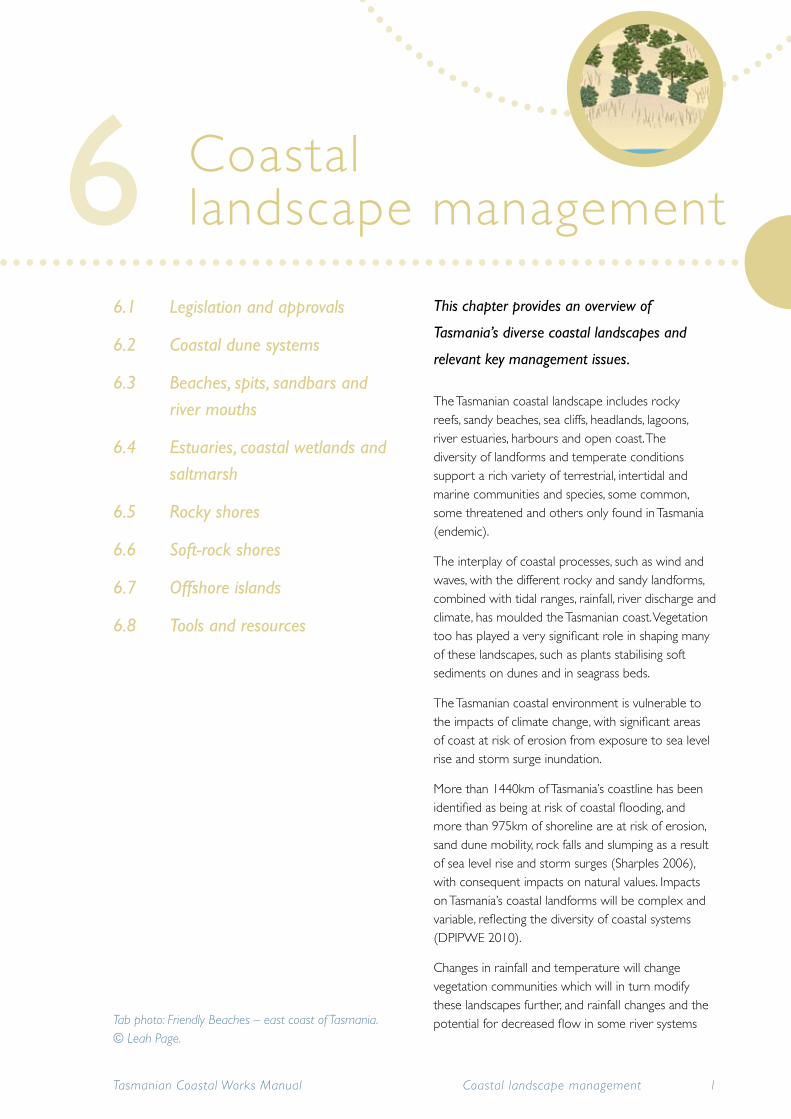
This chapter provides an overview of
Tasmania’s diverse coastal landscapes and
relevant key management issues.
The Tasmanian coastal landscape includes rocky reefs, sandy beaches, sea cliffs, headlands, lagoons, river estuaries, harbours and open coast. The diversity of landforms and temperate conditions support a rich variety of terrestrial, intertidal and marine communities and species, some common, some threatened and others only found in Tasmania (endemic).
The interplay of coastal processes, such as wind and waves, with the different rocky and sandy landforms, combined with tidal ranges, rainfall, river discharge and climate, has moulded the Tasmanian coast. Vegetation too has played a very significant role in shaping many of these landscapes, such as plants stabilising soft sediments on dunes and in seagrass beds.
The Tasmanian coastal environment is vulnerable to the impacts of climate change, with significant areas of coast at risk of erosion from exposure to sea level rise and storm surge inundation.
More than 1440km of Tasmania’s coastline has been identified as being at risk of coastal flooding, and more than 975km of shoreline are at risk of erosion, sand dune mobility, rock falls and slumping as a result of sea level rise and storm surges (Sharples 2006), with consequent impacts on natural values. Impacts on Tasmania’s coastal landforms will be complex and variable, reflecting the diversity of coastal systems (DPIPWE 2010).
Changes in rainfall and temperature will change vegetation communities which will in turn modify these landscapes further, and rainfall changes and the potential for decreased flow in some river systems
Coastal landscape management
Tasmanian Coastal Works Manual 1Coastal landscape management
Tab photo: Friendly Beaches – east coast of Tasmania. © Leah Page.
6
will modify estuarine environments.
Managing unstable coastal landforms such as dunes and beaches is not easy and technical advice is essential. Vegetation management is critical as coastlines alter rapidly when vegetation is destroyed and sediments become re-mobilised.
Inappropriate coastal works can easily be destroyed by waves, tides, currents or winds. In addition they can also cause problems in nearby coastal areas, such as erosion and movement of sand to places where it is not wanted. Coastal works must be undertaken with great care: many works in the past have been ineffective or caused needless damage to coastal values through poor planning and inappropriate techniques.
6.1 Legislation and approvals
Management of coastal landforms such as dunes, beaches and wetlands involves a range of legislation and approval processes that provide for protection of natural and cultural values and authority from land managers. In addition to the legislation detailed in Chapter 1, the most likely legislation to be applied is provided in Appendices 1 and 2.
Permission from the land manager must be given before any management of coastal landscapes takes place, and assessments and approval will probably be required to ensure that coastal values are indentified and protected. Works on Crown land, which includes many coastal reserves and all land below high water mark, require approval from Crown Land Services (DPIPWE). Seek advice from Crown Land Services about which assessments and approvals are required.
Estuaries and river mouths often support port
operations and boating facilities, therefore the Marine and Safety Authority Act 1997 and the Tasmanian Ports Corporation Act 2005 also come into effect in these areas.
6.2 Coastal dune systems
This section describes the role and functions of coastal dune systems and provides guidance on how best to manage these dynamic landforms.
Coastal dunes are generally active landforms, with a few exceptions, and require special management. There is usually a cyclic pattern of erosion and deposition on open coast beaches and foredunes. The vegetation on the dunes plays a vital role in the balance of the dune/beach system by holding the sand in place. Because dunes are highly mobile, sand blows can occur naturally. In fact many plants and animal species (e.g. dune grasses) and various ecosystems depend on dune movement for their survival.
However, human impacts and coastal processes can lead to significant sand blows and erosion that require management. Dune vegetation is easily damaged by vehicles, livestock and pedestrian traffic, burning and grazing. Once the vegetation is gone, it is difficult for plants to re-establish in the dry, loose, wind-blown sand. Loss of dune vegetation may lead to wind and wave erosion and loss of sand from the system.
Stable dunes are fairly rare. Most dune fronts around Tasmania are mobile and the movement of their sand can result in extensive erosion. In some areas, such as south-west Tasmania, this is probably related to the rise in sea level, 14cm since 1841 and still rising (Hunter et al. 2003) and the limited supply of sand. Exceptions include the east coasts of Flinders Island and King Island, where large amounts of sand are accumulating.
Tasmanian Coastal Works Manual2 Coastal landscape management
6.1
6.2.1 Values of dunes
A healthy dune system protects the shoreline from erosion and the backshore from flooding. The sand bank provides for natural replenishment of the beach and the dunes trap wind-blown sand, protecting the coastal landscapes behind. These unique environments support many specialised coastal plants that bind the sand together. Some shorebirds depend on sand dunes for nesting habitat and many other wildlife species depend on the dunes and their vegetation.
Many dunes around Tasmania contain shell middens, as well as other Aboriginal values, such as artefact scatters, that are important Aboriginal heritage places.
Coastal dunes are one of the important coastal landscapes for monitoring the impact of changes in sea level, because they erode quickly when the sea is rising.
Geoconservation values of coastal dunes
Coastal dunes and other sandy landforms are an important part of our heritage and are protected for their geoconservation values. Tasmania’s many sandy landforms include: parallel dunes at Marion Bay; beach ridges at Seven Mile Beach; parabolic dunes at Henty dunes; headland bypass dunes at Stephens Bay–Noyhener Beach in the south-west; and cliff-top dunes at Cape Deslacs at Clifton Beach. Dating some of the Henty dunes at Strahan has shown them to be 500 000 years old (Bradbury, J. pers. comm. 14th Sept 2010).
Some sites of geoconservation significance may be fossil (non-renewable) and there are numerous fossil dune forms and fossil shorelines inland of the current coast, some of which preserve evidence of coastal processes during the last Interglacial phase circa 125 000 years ago. Other geoconservation sites are active landforms that require maintenance of the natural rates of change and movement.
Tasmanian Coastal Works Manual 3Coastal landscape management
6.2
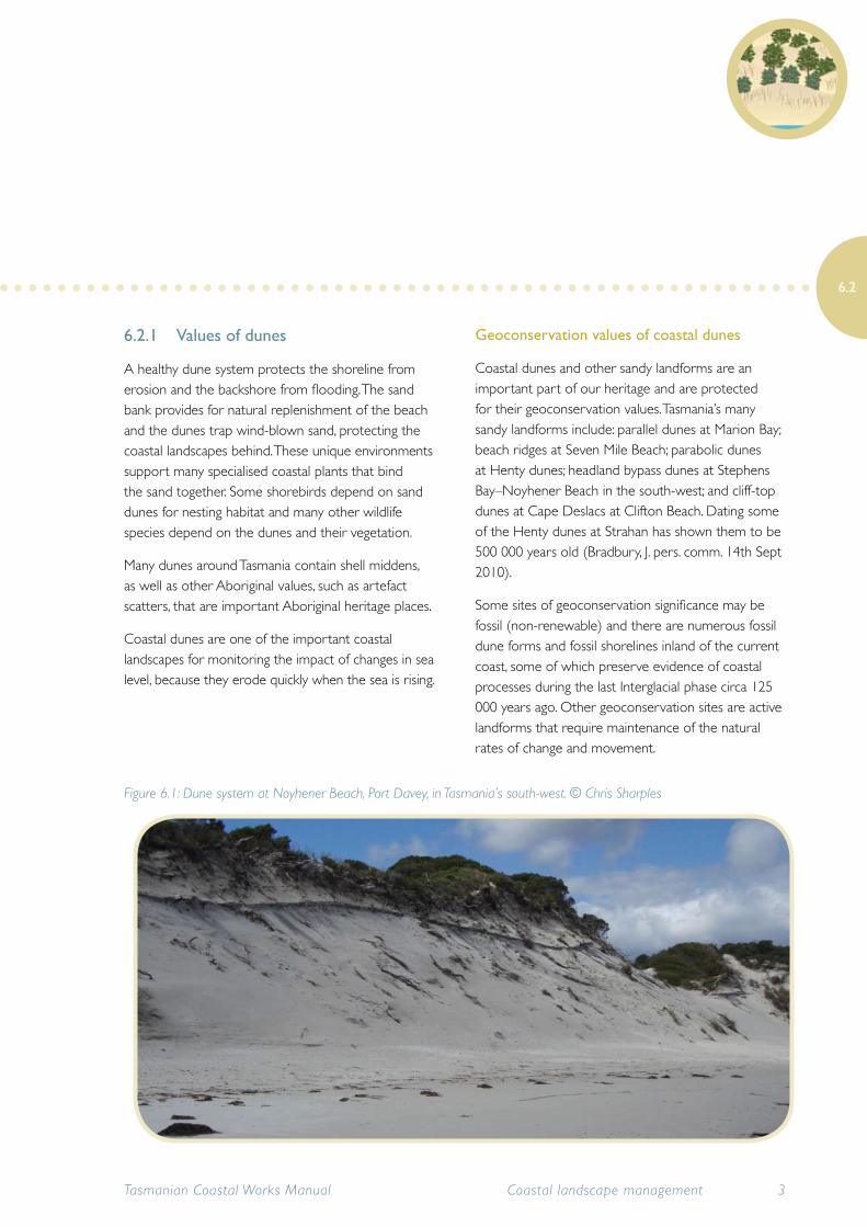
Figure 6.1: Dune system at Noyhener Beach, Port Davey, in Tasmania’s south-west. © Chris Sharples
Many outstanding landscapes and areas of high nature conservation value are protected as parks and reserves. Most significant sites have management plans that control developments, for instance, local government planning schemes often have ‘visual protection areas’.
Trying to stabilise dunes may not be appropriate at sites with high geoconservation values. In some areas, especially along the north-east and west coasts, some dunes are naturally mobile, and attempting to stabilise the sand may interfere with natural processes and values. Before attempting such work, seek advice from a coastal geomorphologist and refer to the Tasmanian Geoconservation Database on Tasmania’s Land Information System (the LIST) on the internet.
6.2.2 Understanding dune systems
Coastal sand dunes are formed by the transport of sand onto the beach by wave action and then landward from the beach by wind. Vegetation growing on the shoreline traps the sand, forming a ridge. Dune grasses colonise these ridges and more sand builds up over time, forming a dune.
Successive lines of dunes can form parallel dunes, where slow shoreline growth or ‘progradation’ has occurred. Where phases of rapid shoreline growth have occurred in the past, a series of lower parallel beach ridges may exist behind the present shore, representing earlier temporary shoreline positions.
Under stable sea level conditions, the seaward side of the dune system is maintained by the cyclic patterns of erosion and deposition. The dunes further landward become stabilised by vegetation. The dunes on the seaward side, known as foredunes, are regularly eroded by storm waves, and replenished during calmer weather when waves bring sand back to the beach.
Dune vegetation plays an important role by trapping sand and stabilising the dunes. Dune vegetation is specially adapted to withstand the windy, salty environment. The type of dune vegetation determines the shape and profile of the dunes. The protection provided by the foredunes enables more complex vegetation to develop in the hind dunes.
Under some conditions, including vegetation dieback or increased storm erosion frequency, foredunes and hind-dunes may become unstable, with blowouts developing into parabolic (or transgressive) dunes that move inland. This occurs naturally in many cases, but can also be triggered by human disturbances.
Tasmanian Coastal Works Manual4 Coastal landscape management
6.2
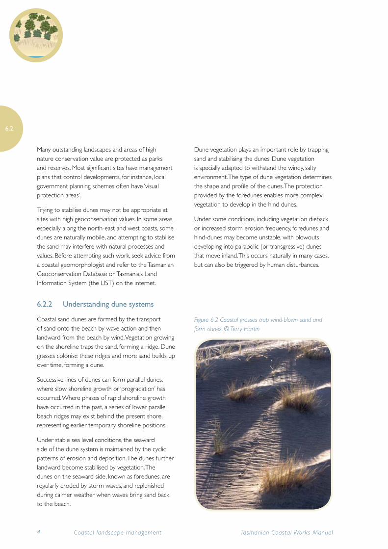
Figure 6.2 Coastal grasses trap wind-blown sand and form dunes. © Terry Hartin
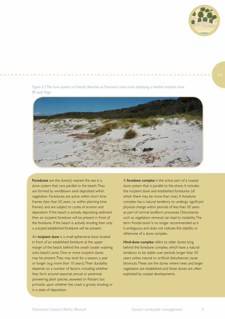
Foredunes are the dune(s) nearest the sea in a dune system that runs parallel to the beach. They are formed by windblown sand deposited within vegetation. Foredunes are active within short time frames (less than 50 years, i.e. within planning time frames) and are subject to cycles of erosion and deposition. If the beach is actively depositing sediment then an incipient foredune will be present in front of the foredune. If the beach is actively eroding then only a scarped established foredune will be present.
An incipient dune is a small ephemeral dune located in front of an established foredune at the upper margin of the beach, behind the swash (water washing onto beach) zone. One or more incipient dunes may be present. They may exist for a season, a year or longer (e.g. more than 10 years). Their durability depends on a number of factors, including whether they form around seasonal, annual or perennial pioneering plant species, seaweed or flotsam, but primarily upon whether the coast is grossly eroding or in a state of deposition.
A foredune complex is the active part of a coastal dune system that is parallel to the shore. It includes the incipient dune and established foredunes (of which there may be more than one). A foredune complex has a natural tendency to undergo significant physical change within periods of less than 50 years as part of normal landform processes. Disturbance such as vegetation removal can lead to instability. The term ‘frontal dune’ is no longer recommended as it is ambiguous and does not indicate the stability or otherwise of a dune complex.
Hind-dune complex refers to older dunes lying behind the foredune complex, which have a natural tendency to be stable over periods longer than 50 years unless natural or artificial disturbances cause blowouts. These are the dunes where trees and larger vegetation are established and these dunes are often exploited by coastal developments.
Tasmanian Coastal Works Manual 5Coastal landscape management
6.2
Figure 6.3 The dune system at Friendly Beaches on Tasmania’s east coast displaying a healthy incipient dune. © Leah Page
6.2.3 Dune management
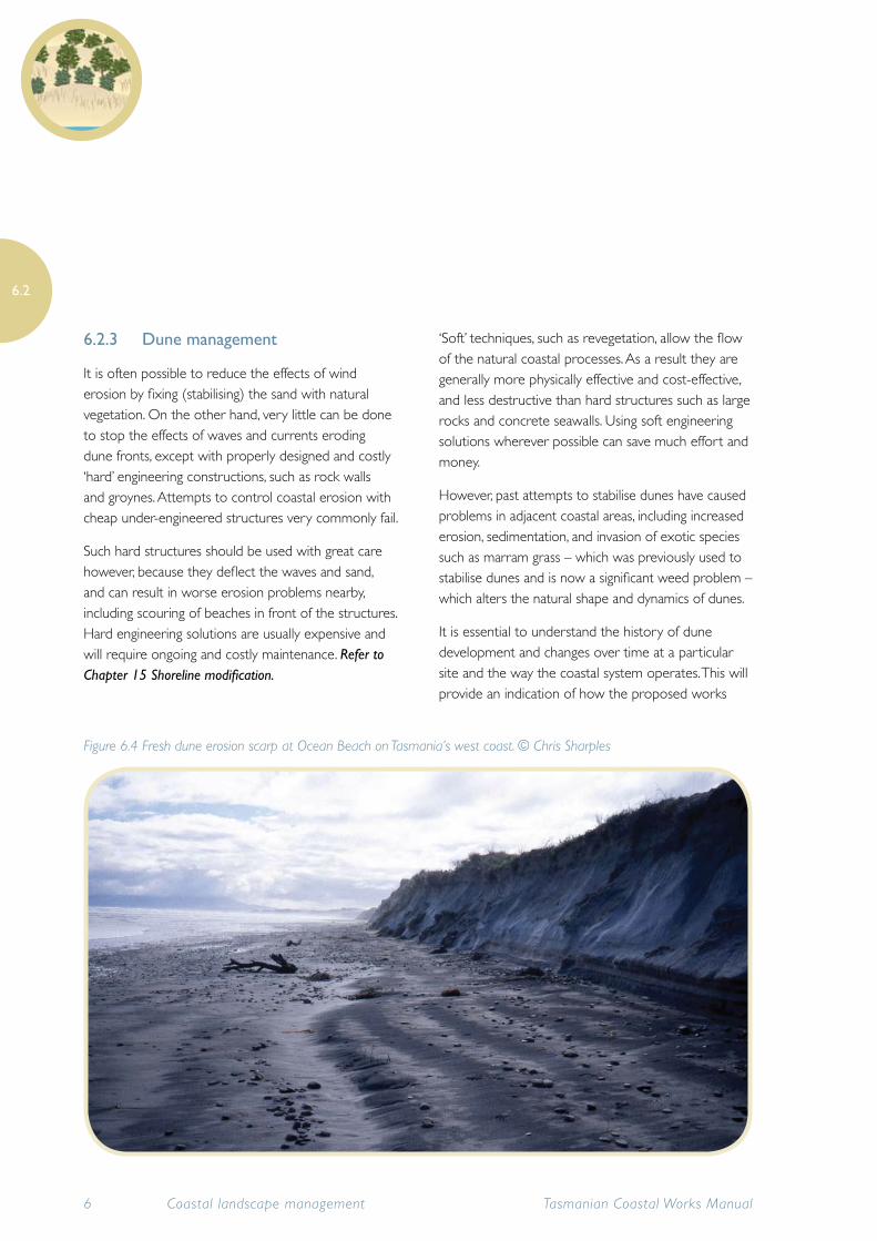
It is often possible to reduce the effects of wind erosion by fixing (stabilising) the sand with natural vegetation. On the other hand, very little can be done to stop the effects of waves and currents eroding dune fronts, except with properly designed and costly ‘hard’ engineering constructions, such as rock walls and groynes. Attempts to control coastal erosion with cheap under-engineered structures very commonly fail.
Such hard structures should be used with great care however, because they deflect the waves and sand, and can result in worse erosion problems nearby, including scouring of beaches in front of the structures. Hard engineering solutions are usually expensive and will require ongoing and costly maintenance. Refer to Chapter 15 Shoreline modification.
‘Soft’ techniques, such as revegetation, allow the flow of the natural coastal processes. As a result they are generally more physically effective and cost-effective, and less destructive than hard structures such as large rocks and concrete seawalls. Using soft engineering solutions wherever possible can save much effort and money.
However, past attempts to stabilise dunes have caused problems in adjacent coastal areas, including increased erosion, sedimentation, and invasion of exotic species such as marram grass – which was previously used to stabilise dunes and is now a significant weed problem – which alters the natural shape and dynamics of dunes.
It is essential to understand the history of dune development and changes over time at a particular site and the way the coastal system operates. This will provide an indication of how the proposed works
Tasmanian Coastal Works Manual6 Coastal landscape management
6.2
Figure 6.4 Fresh dune erosion scarp at Ocean Beach on Tasmania’s west coast. © Chris Sharples
may alter sand movement. Often, with careful planning and assessments of the direction of dune movement and sand availability, past problems can be avoided.
Many dunes are naturally unstable and mobile. These can be very difficult to stabilise permanently and the reasons for doing so need to be clearly justified and worth the effort and expense that will be required.
6.2.4 Types of dune conservation and stabilisation works
Stabilisation may be appropriate where there is a small blowout, or erosion caused by vegetation damage or removal. Using structures such as mesh fences, brush mulches or geotextiles slows the movement of sand so that plants can establish and hold the sand in place.
Avoid works in the foredunes unless they are to maintain access to the foreshore or for protective or rehabilitation work.
The types of works selected will depend on the purpose, budget and the site conditions. Suitable works may include any or all of the following:
• dune-forming fences (mesh or brush)
• geotextiles, jute mesh, brush mulches and other surface stabilisation methods
• revegetation (refer to Chapter 7)
• access control: fences, barriers, signs (refer to Chapter 13)
Repairing erosion caused by wave attack is very difficult and costly. Such repair works are usually unsuccessful and it is impossible to fix dune fronts on eroding beaches in the long term. The natural erosion (coastal recession) of many beaches will increase with the predicted rise in sea level and will become increasingly harder to prevent with artificial interventions as sea level continues to rise.
6.2.5 Assessing dune erosion
Before planning rehabilitation works, assess whether the problem is caused by natural coastal processes or human activities, and whether it is possible to manage the sand movement or erosion.
Dune erosion, sand blows and blowouts do not need treatment if they are caused by natural processes and/or are not causing a problem. Erosion and small blowouts caused by human activities, such as grazing livestock or on- or off-road vehicles, may require stabilisation.
Seek specialist advice to identify the factors that drive natural coastal dune processes, in particular the seasonal patterns in wind speed, wind direction, tide and wave action, the natural dune mobility or stability that might be expected given local rainfall, micro-topography and exposure to winds, and the likely effects of the works.
If a dune blowout appears to be caused by human activity, find out whether the blowout is growing or stabilising by itself. If revegetation is occurring naturally, the blowout may stabilise by itself.
Even large coastal sand blows will eventually stop within some hundreds of metres from the beach. If a foredune is receding, assess foredune erosion to see if the problem can or should be treated.
Dune erosion can be measured by establishing a benchmark behind the dune. Take measurements at regular intervals from the benchmark over the dune, to the dune erosion scarp. Ideally, the protocols used in the Tasmanian shoreline monitoring and archiving (TASMARC) project should be adopted. Refer to Chapter 2 Climate change and the coast
Tasmanian Coastal Works Manual 7Coastal landscape management
6.2
6.2.6 Methods for stabilising dunes impacted by wind erosion
The main methods of stabilising dunes are to remove human activities that are causing the problem, and/or to obstruct wind erosion with fences, mulches, jute mesh or geotextiles so as to allow revegetation.
The methods described here are suitable for relatively small sand blows and minor erosion of foredunes caused by local artificial disturbances (unless the beach and dune is steadily receding due to natural coastal processes or recent sea level rise).
It is important to monitor the works carefully to assess success and to repair any damage quickly.
Remove destabilising activities and allow natural regeneration
If a dune has started to blow due to human activity, such as inappropriate access, immediately take steps to control the activity. Otherwise there is no point trying to fix the damage.
Choose a suitable method for stabilisation. Consider leaving the area to fix itself by fencing it off and monitor the result for up to a year (or less if revegetation is too slow to stabilise the site). Reduce or restrict access to the area while it is being rehabilitated.
Do not allow livestock to graze there, and keep them off dunes after stabilisation. Avoid grazing on dunes that are mobile or potentially mobile.
Tasmanian Coastal Works Manual8 Coastal landscape management
6.2
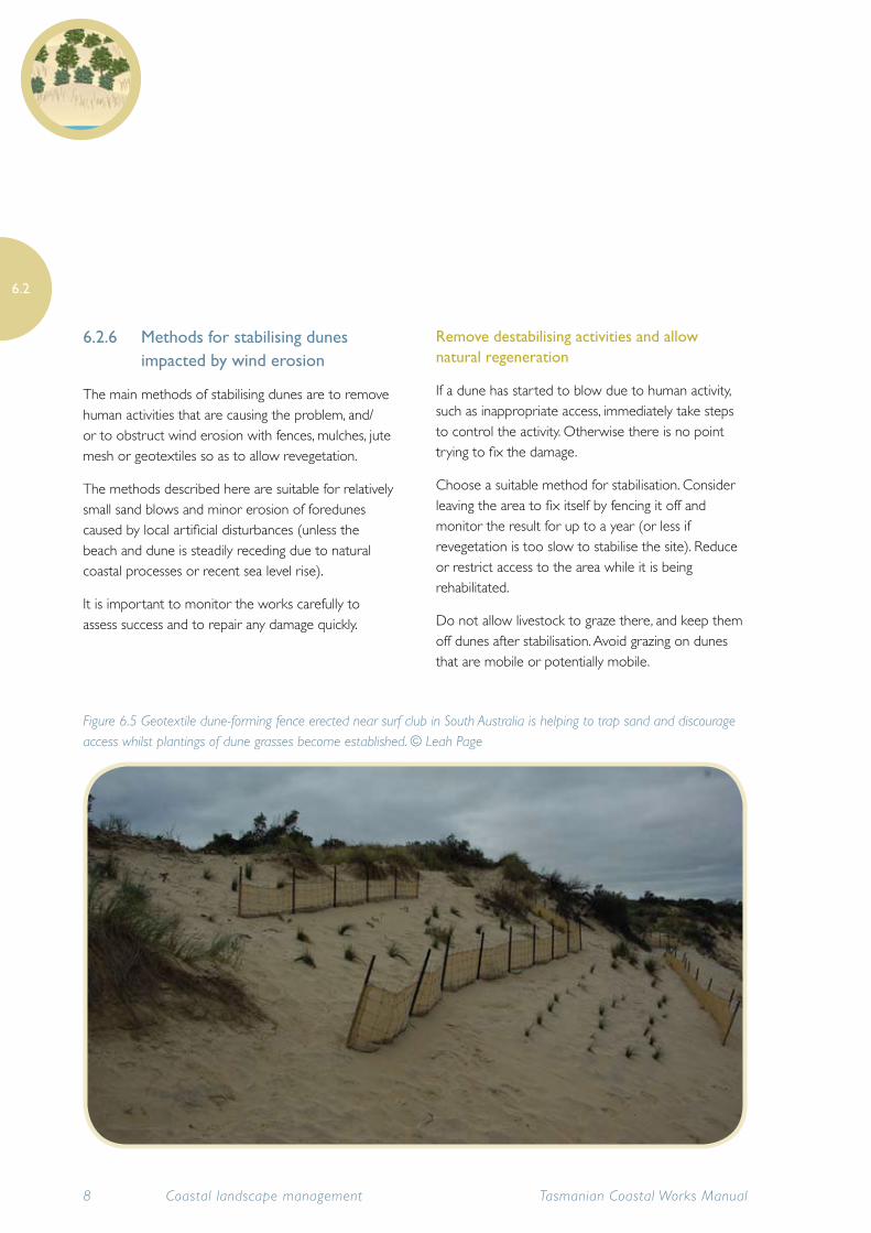
Figure 6.5 Geotextile dune-forming fence erected near surf club in South Australia is helping to trap sand and discourage access whilst plantings of dune grasses become established. © Leah Page
Use dune-forming fences, brush or textiles
If a sand blow does not stabilise by itself, these methods will reduce erosion. They slow the ground-level wind speed and allow sand to deposit. Then native vegetation can establish and start to bind the sand.
Dune-forming fences are useful for small blowouts and areas where stabilisation could take some years. They are more permanent than brush mulches, jute mesh or geotextiles and are cost-effective, but take several years to work. These fences are meant to be covered by sand and can stay in place when this happens; then, if a higher dune is required, construct another fence on top.
Avoid using dune-forming fences along a progressively or frequently eroding beachfront, as they will not be successful unless the prevailing wind blows straight onto the beach, allowing sand blown off the beach to rebuild dunes faster than storms are eroding them. There must also be enough sand supply in the dune-beach system to rebuild the dunes, which is rarely the case on a progressively receding shore.
Obtain specialist advice about where and how fences should be placed. This will be based on the site conditions, including prevailing wind speeds and directions. Choose the cheapest materials if the fences are likely to be buried quickly.
The most important areas of a sand blow to stabilise are the edges, especially the forward edge and other places where the wind is funnelling sand away more quickly.
During works, protect the vegetation that stabilises the sand by restricting access by vehicles and people.
Assess the need for revegetation. If there is no natural vegetation nearby to supply seed, plant the area with appropriate local native species, or use direct seeding
after the works are in place. Refer to Chapter 7 Vegetation management.
Geotextiles and jute mesh fabrics
Geotextiles are mesh materials that help to stabilise the sand and retain water. But they quickly become covered with sand if there is a lot of sand movement. Geotextiles can be expensive and can be easily vandalised. For stabilising sand dunes they are only recommended for difficult sites or where urgent repairs are needed. However, geotextile sand bags are a useful product for creating banks and revetments and have been used successfully in other Australian states to stabilise eroded foreshores. Refer to Chapter 15 Shoreline modification.
Choose a cost-effective textile. Jute mesh is relatively cheap, it allows light through, and plants can grow through it. Jute mesh lasts longer if it is placed as a double layer. It breaks down after a few years, so replace it if revegetation is very slow.
Peg the edges down well to stop the wind from dislodging the material. Secure the mesh by placing it at least 1m into stable vegetation on each side. Check regularly that the textile is not becoming loose or damaged.
Do not use geotextiles in accessways as they will trap sand and obstruct access.
6.2.7 Ongoing maintenance of dune stabilisation works
All dune stabilisation works require regular maintenance to make sure they are in good repair and are effective. Dunes are so unstable that works can be very quickly damaged or destroyed by wind and waves. Inspect and carry out maintenance on new works after stormy periods.
Tasmanian Coastal Works Manual 9Coastal landscape management
6.2
Inspection and maintenance should check that:
• structures are in place and secured, especially at the margins of the erosion
• access to the area is controlled adequately so rehabilitation can occur
• erosion is not getting worse
• structures are not becoming a hazard to the public.
6.2.8 Climate change and dune systems
Recent climate science has progressed significantly since the Intergovernmental Panel on Climate Change’s (IPCC) Fourth Assessment Report (IPCC 2007), and sea level rise projections are currently being revised upwards.
Climate change and sea level rise impacts on dunes include more frequent storms removing sand from the dune system and foredunes changing shape and receding in response to the removal of sand. Provided the dune system is healthy, the dunes can migrate landwards as shorelines retreat. However in areas where very little dune system remains, the rise in sea level and more frequent storms could result in complete loss of this natural buffer and associated habitats, leading to increased erosion and inundation of coastal areas.
Monitoring of dunes may be able to provide an indication of climate change. Many Tasmanian beaches show evidence of ongoing retreat and some of progradation (build-up or growth) over the past few decades. It is likely that at least some of the erosion and retreat is linked to recent sea level rise induced by climate change; however, it is difficult to tell how much is just a part of natural variability.
The vulnerability of coastal systems to climate change is exacerbated by increasing human-induced pressures
in the coastal zone. Coastlines that are subject to development have a lower capacity to adapt to changes in sea level, because they are no longer in their natural state of being dynamic and highly mobile. In addition, if human responses to rising sea levels are to defend the coast with artificial structures such as seawalls, the existing potential for natural shoreline adjustment to the changing conditions will be further reduced (DPIPWE 2010).
6.3 Beaches, spits, sandbars and sandy river mouths
This section describes the extremely dynamic coastal landforms of beaches, spits, river mouths and barways, the coastal processes that shape them and techniques for managing these landscapes.
The erosion and movement of sand along sandy coasts can cause problems such as loss of beaches and the growth of sandbars and spits. Continual sand movement and change is an ongoing natural process on many coasts, but problems may be caused or exacerbated by human constructions such as hardening of the foreshore, bridges and groynes, or dams upstream restricting water flows through river mouths.
It is critical to understand how a coastal system operates before doing any proposed works, so that you can predict the effects of proposed works and deal wisely with any changes to the movement of sand. This is particularly important now, with climate change and projected sea level rises predicted to increase storm erosion of sandy landforms. Proper planning, design and maintenance of appropriate beach and sandy coast conservation and remediation works will make these land management activities more effective.
Tasmanian Coastal Works Manual10 Coastal landscape management
6.3
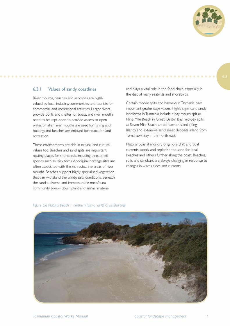
6.3.1 Values of sandy coastlines
River mouths, beaches and sandspits are highly valued by local industry, communities and tourists for commercial and recreational activities. Larger rivers provide ports and shelter for boats, and river mouths need to be kept open to provide access to open water. Smaller river mouths are used for fishing and boating; and beaches are enjoyed for relaxation and recreation.
These environments are rich in natural and cultural values too. Beaches and sand spits are important nesting places for shorebirds, including threatened species such as fairy terns. Aboriginal heritage sites are often associated with the rich estuarine areas of river mouths. Beaches support highly specialised vegetation that can withstand the windy, salty conditions. Beneath the sand a diverse and immeasurable meiofauna community breaks down plant and animal material
and plays a vital role in the food chain, especially in the diet of many seabirds and shorebirds.
Certain mobile spits and barways in Tasmania have important geoheritage values. Highly significant sandy landforms in Tasmania include a bay mouth spit at Nine Mile Beach in Great Oyster Bay; mid-bay spits at Seven Mile Beach; an old barrier island (King Island) and extensive sand sheet deposits inland from Tomahawk Bay in the north-east.
Natural coastal erosion, longshore drift and tidal currents supply and replenish the sand for local beaches and others further along the coast. Beaches, spits and sandbars are always changing in response to changes in waves, tides and currents.
Tasmanian Coastal Works Manual 11Coastal landscape management
6.3
Figure 6.6 Natural beach in northern Tasmania. © Chris Sharples
6.3.2 Managing beaches, spits, barways and sandy river mouths
Waves, wind and currents move sand along many open coastlines by a process known as longshore drift. Beach sand is also moved on and off the shore by the action of waves, tides and currents. During stormy weather or large swells, sand is removed from the beach and deposited offshore in sand bars. During calmer weather the waves deposit the sand back onto the beach, forming a berm or ridge parallel to the shoreline.
Storm waves can move huge amounts of sand quite quickly. Beaches and sand spits can also lose or gain sand as a result of damage to adjacent foredunes by human activities such as sand extraction, vehicle and pedestrian access, burning and grazing.
Structures that are built in an attempt to control the movement of sand include groynes, breakwaters, seawalls and river training walls. However, these coastal protection works are expensive to build and maintain, and long-term success is difficult to achieve. Hard structures (e.g. concrete seawalls) on soft sandy coastlines affect wave patterns and can lead to erosion nearby.
Many of these structures have been built without adequate understanding of local processes, or are under-engineered, and continue to cause local problems. Before planning new constructions, it is crucial to get proper assessments of coastal processes (the actions and interactions of wind, waves and currents) and proper engineering advice, and to consider potential sea level rise.
Such works usually need regular maintenance and, unless they are extremely robust, will normally only buy some time for a particular section of eroding coast. It is much cheaper and more environmentally sound to avoid trying to control the movement of sand and waves on sandy coasts, and plan developments in sympathy with existing coastal processes.
Choosing the appropriate site is critical for structures that extend across the shore and/or into the water, such as groynes. Such structures are susceptible to wave erosion and sediment build-up, as well as corrosion from salt water, and can be expensive to maintain. Resilient but permeable structures are generally preferable to rigid and impermeable structures that resist wind and waves and impede sediment movement.
It is extremely difficult to stabilise river mouths and spits. Spits will always form in the direction of the prevailing waves. Works to protect beaches from erosion caused by wave attack, or to breach spits or maintain barways, are very difficult and costly, and may require heavy machinery, which can cause severe damage to adjacent areas. Refer also to Section 15.1.6 Seawalls.
Where recession of beaches is causing concern, land managers and residents might consider artificially replenishing the beach, known as beach nourishment. However, this requires intensive research, is expensive and ongoing and may create unforseen impacts on the coastal ecosystem. Nonetheless, in some urbanised and highly valuable recreational beaches it may be a desirable management option. Refer to Chapter 15 Shoreline modification.
Tasmanian Coastal Works Manual12 Coastal landscape management
6.3
6.3.3 Guidelines for working on barways, spits and sandy river mouths
Sandbars, barways, spits and river mouths are highly mobile systems. They should be left alone where possible, to protect natural ecosystems – and to avoid considerable ongoing expenses. Many coastal lagoons are temporarily cut off from the sea by the growth of a sandbar, which may be breached after heavy rain, usually in winter.
Where a barway is causing elevated water levels upstream that threaten property and infrastructure, artificial opening may be necessary. Ecological consequences need to be balanced against economic damage and systems have been developed to facilitate the prior identification of trigger points when breaching is justified. The Victorian Estuary entrance management support system (EEMSS) (Arundel 2006)
provides information to guide land managers.
In locations where shipping and boating is a priority, river training walls are sometimes built on either side of a river mouth to improve navigation. The constricting walls are designed to speed up the water flow, which increases the scouring action of the river so as to prevent build-up of sandbars in the river mouth. However, training walls at river mouths exposed to longshore drift can cause shoreline erosion on their downdrift side and can be undermined, or cause sand to be deposited where the training wall ends, unless the training walls terminate in deep water on the seaward side of the structure.
Before starting works, thorough investigation and planning is essential. This may take some time. Obtain specialist advice from an experienced coastal
Tasmanian Coastal Works Manual 13Coastal landscape management
6.3
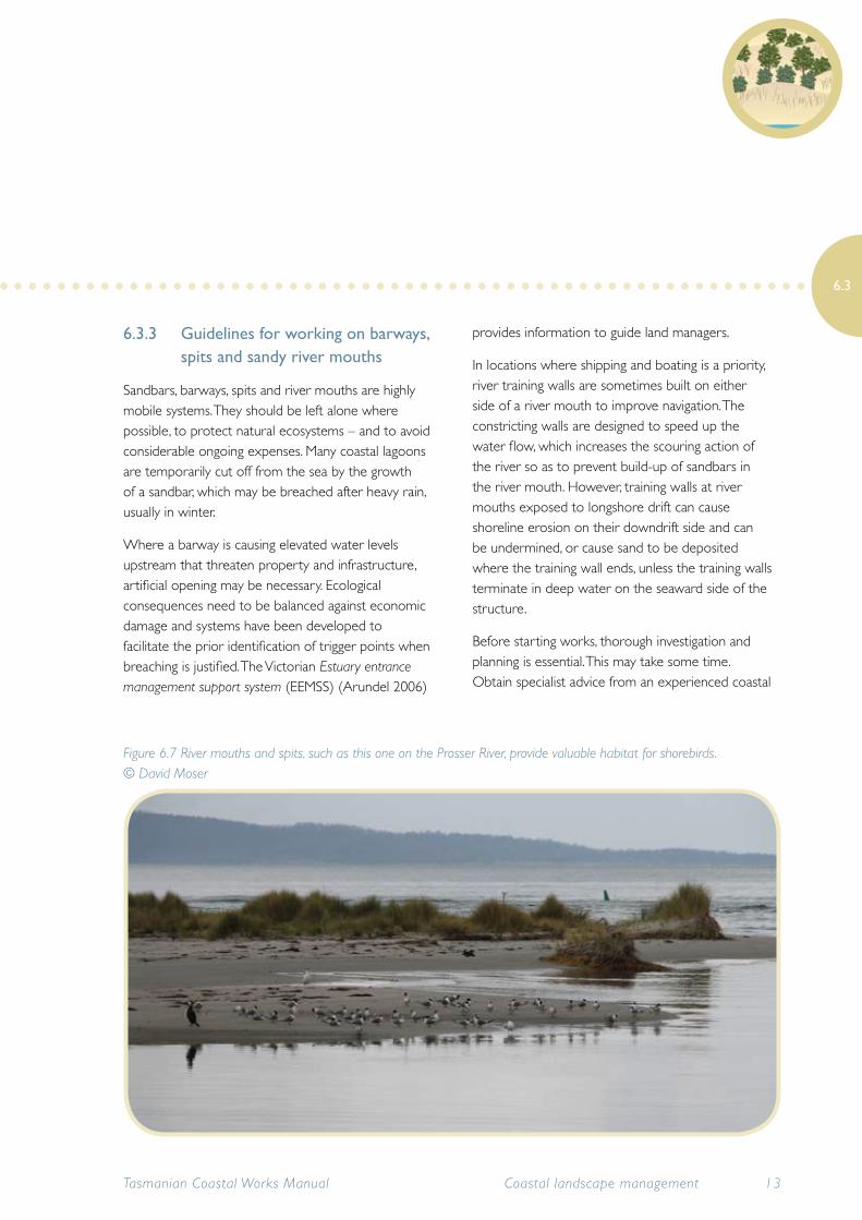
Figure 6.7 River mouths and spits, such as this one on the Prosser River, provide valuable habitat for shorebirds. © David Moser
geomorphologist, who can advise on the natural sand movements. If structures are being considered, consult a coastal engineer to ensure a properly designed structure. Specialist advice is essential to find out whether managing sand movement is possible and will save you money in the long term.
Potential environmental impacts
• Breaching barways or spits can greatly alter the movement of sand and currents, sometimes with unexpected effects. To keep them open in the long run, expensive ongoing maintenance work is inevitable.
• River training walls can act as groynes, and often project much further out to sea than ordinary groynes, with the potential to cause extensive erosion further along the coast.
• Disturbing beaches, barways, spits and river mouths may damage valuable habitat for wildlife, including shorebirds and marine life.
• Disturbing sandy landforms may damage Aboriginal heritage places or geoconservation values.
Minimise environmental impacts
Obtain specialist advice from a coastal geomorphologist to identify what drives the natural coastal processes (seasonal patterns in wind speed, wind direction, tides and wave action) and the likely changes to sand movement and coastal processes that will result from the works.
Obtain specialist advice on the potential impact on any Aboriginal heritage, historic sites or geoheritage sites.
Identify the cause of the problem. Beach erosion and moving or growing barways and spits do not need treatment if they are caused by natural processes and
if artificial developments have been appropriately sited to avoid damage from natural coastal mobility. However, where erosion and sand movement is caused by human activities disturbing the natural sand transport patterns, and this is causing a problem, then intervention may be necessary.
Barways and coastal lagoon barriers should not be breached unless public safety is demonstrably at risk, water quality is a risk to public health or there is significant risk of economic damage to property or land.
If breaching of spits and barways is required (e.g. to prevent flooding or allow boat access), it should only be undertaken with extreme caution. Breaching a barred lagoon at the end of winter rains, if that is when the barway normally opens, may cause less harm than breaching in summer.
Obtain specialist advice about the potential impacts of breaching a lagoon barrier. Consider the local watercourse and catchment and waterbirds, aquatic life and other wildlife. The ecosystems and life in coastal lagoons are adapted to the natural seasonal changes in water level.
Design and engineer the river training walls properly to minimise erosion of the riverbed, which can undermine the walls. To limit erosion, sand can be pumped from the updrift shore to the downdrift shoreline, bypassing the training walls. But these are expensive and ongoing operations. Also, sand might be deposited where the training wall ends (because the river flow slows and loses energy), meaning that the training wall needs to be extended into deeper water (where sand deposition is not an issue). If sand is deposited after training walls are constructed, dredging may be required. Refer to Chapter 15 Shoreline modification.
Tasmanian Coastal Works Manual14 Coastal landscape management
6.3
6.3.4 Climate change and beaches, barways, spits and river mouths
Climate change impacts in coastal areas are not limited to sea level rise. Changes to rainfall will affect river flows, which affects the natural flushing regime of river mouths. In areas where rainfall has decreased and water has already been diverted for agricultural reasons, the river flows may be reduced dramatically enough that the river mouth becomes closed off by sediment. However in open river mouths the rising sea level and increased storminess is likely to result in increased erosion of soft estuarine river banks.
All of these changes in sediment flows have implications for maintaining beaches for recreation, river access and barways for boating, and the natural habitats and values of the coastal environment such as sand spits for shorebird nesting.
Beaches with healthy dune systems have more resilience to climate change impacts. Sand in healthy beach-dune systems is episodically exchanged between the dune, beach and subtidal zone in an ongoing cycle. Storm waves remove sand into the subtidal zone and gentle waves return sand to the beach where it is blown back into the dunes. This process is still counteracting sea level rise effects on many Australian open coast sandy beaches. Refer to section 6.1 Coastal dune systems.
Some beaches will be highly susceptible to loss of sand from increased storm activity and higher sea levels. These beaches are the ones with no supply of sediment or wave action to replenish the losses. Beaches where artificial disturbances have already modified the sand supply may be more susceptible to receding due to sea level rise than otherwise would have been the case.
Tasmanian Coastal Works Manual 15Coastal landscape management
6.3
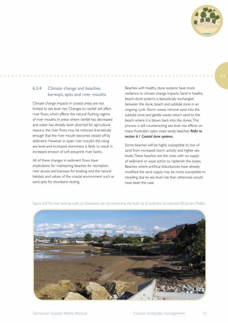
Figure 6.8 The river training walls at Ulverstone are not preventing the build up of sediment as intended. © Jocelyn Phillips
The IPCC is revising sea level rise projections since its Fourth Assessment Report (IPCC 2007). It is likely that coastal communities are going to put increased pressure on land managers to protect beaches from erosion and recession.
However it is neither possible nor desirable to defend all erodible shores. Land managers are going to need to assess locations to determine for which areas beach protection works are suitable and viable and which areas should be allowed to recede and find a natural equilibrium.
It is increasingly important to protect the natural areas and values that remain from human impacts because the added pressure of climate change and sea level rise will result in increased stresses on these environments, making it harder for these ecosystems to adapt.
6.4 Estuaries, coastal wetlands and saltmarsh
This section provides information on the diverse waterway and wetland landscapes of Tasmania and some key management issues that must be considered in these areas. This manual is only concerned with estuaries and coastal wetlands such as saltmarsh, intertidal flats and coastal lagoons and not freshwater systems or inland lakes.
The Tasmanian coastline has a large number of estuaries due to the many coves, embayments and river systems. The two most significant estuaries from a land management perspective are the Tamar Estuary in the north and the Derwent Estuary in the south.
Coastal estuaries and wetlands in Tasmania support significant seagrass beds which are important fish
nursery areas. The diverse range of wetland types, including lagoons, saltmarsh and mudflats, all have specialised and unique vegetation communities and provide important habitat to coastal wildlife. Protecting the water quality in estuaries and wetlands is essential for the health of many aquatic species, habitats and ecosystems, including fish and other marine life such as seagrass and kelp.
Coastal embayments (sometimes known as coastal re-entrants) are important landscapes for indicating sea level rise impacts due to climate change. Their sheltered location away from ocean waves and swell means that they are not readily replenished with sand and erosion activity is therefore ongoing and obvious.
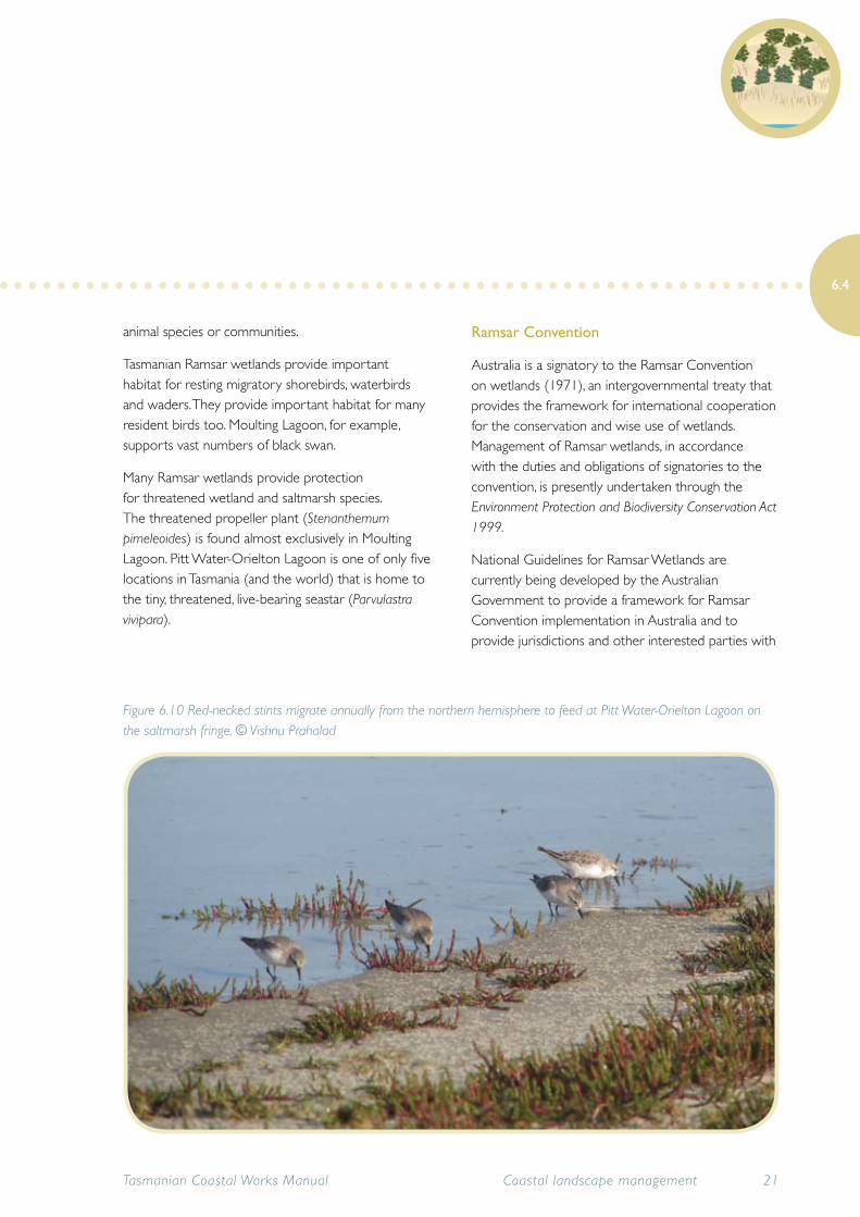
Tasmania has numerous coastal habitats of significant conservation value, including several Ramsar wetlands of international significance recognised for their migratory bird values, such as Pitt Water-Orielton Lagoon, Moulting Lagoon and Lavinia State Reserve (a feeding stopover on King Island for the endangered orange-bellied parrot). The Robbins Passage–Boullanger Bay wetlands in the far north-west provide breeding, roosting and feeding habitat for the largest diversity and density of migratory and resident shorebirds found anywhere in Tasmania, with more shorebirds present there than the rest of Tasmania combined.
Tasmanian Coastal Works Manual16 Coastal landscape management
6.4
6.4.1 Estuaries
An estuary is a semi-enclosed or periodically closed coastal body of water in which the aquatic environment is affected by both freshwater and marine systems.
The convoluted Tasmanian coastline results in a number of marine embayments, many of which have estuaries associated with them. Each estuary is a unique environment due to its shape, size, depth, degree of tidal variation and catchment characteristics such as rainfall, runoff and vegetation cover. Tasmania has many types of estuaries including coastal inlets, drowned river valleys, barrier estuaries, river estuaries and coastal lagoons.
Presently, catchments in the west, north-west and south are characterised by high rainfall and runoff, resulting a predominance of river estuaries, whereas catchments in the east and north-east are relatively dry and barrier estuaries and coastal lagoons dominate. Estuaries in the north possess much greater tidal ranges (approximately 3m) than those on the east, south and west coasts (1m).
Because the nature of estuaries is determined by a balance of factors such as rainfall, tidal levels, and vegetation cover, they are highly susceptible to climate change impacts. Significant changes in the types of estuaries that can be supported at different sites around Tasmania can be expected as climatic changes become more pronounced.
Tasmanian Coastal Works Manual 17Coastal landscape management
6.4
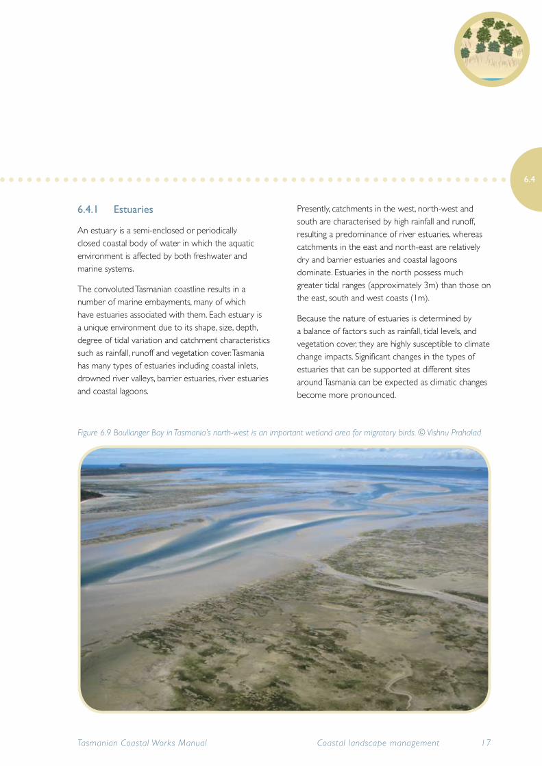
Figure 6.9 Boullanger Bay in Tasmania’s north-west is an important wetland area for migratory birds. © Vishnu Prahalad
The sheltered tidal waters of estuaries support unique communities of plants and animals which are specially adapted for life at the margin of the sea, and estuarine environments are among the most productive on earth. A wide range of habitat types is found in and around estuaries. In temperate regions such as Tasmania, these include beaches and dunes, rocky foreshores, saltmarshes and other wetlands, intertidal flats, seagrass beds, kelp forests and rocky reefs.
Estuaries are essential for the survival of many birds, fish and mammals. Estuaries have been referred to as the ‘nurseries of the sea’, as they provide many species of fish with sheltered waters for spawning and safe habitat for juveniles to develop. Many commercially valuable fish species depend on estuaries during some point in their life cycles. Some migratory birds rely on estuaries as resting and feeding grounds during their long journeys.
Most of Tasmania’s major cities and towns are situated on estuaries, from which they receive many direct economic benefits. Tourism, fisheries, aquaculture and other commercial activities thrive on the natural resources supplied by estuaries and their protected coastal waters support important public infrastructure, providing ports and harbours vital for shipping, transport and industry.
In Tasmania, many of the remaining Aboriginal sites are situated along estuarine shorelines. Estuaries and their surrounds also offer aesthetic and recreational pleasures such as boating, fishing, swimming and birdwatching.
Human use and development creates significant pressures such as agricultural runoff from the catchment, development of foreshore areas and the impacts associated with intensive human use, all of which affect the water quality of the estuary as well as impacting on other coastal values.
Rice grass (Spartina anglica) is an invasive weed that often occupies the intertidal, muddy flats of estuaries. This weed is a threat to the ecology of estuaries and adjacent saltmarshes, changing native flora and fauna habitat. In Tasmania, the major infestations are in the Smithton, Rubicon/Port Sorell, Tamar River, Bridport, St Helens/Georges Bay, Little Swanport and Derwent Estuary regions (DPIPWE website accessed 7th October 2010).
Seagrass beds
A number of estuarine and other sheltered coastal environments support extensive seagrass beds, the most significant of which is Robbins Passage in north-west Tasmania. Whilst not an estuary, this extensive sheltered waterway supports vast areas of seagrass. Seagrass beds help to stabilise coastal sediments and are important fish nursery areas. They are some of the most productive ecosystems on earth but are in decline and are threatened by water pollution and disturbance of the sea floor. It is important to ensure that any activities such as dredging and boat moorings avoid seagrass.
6.4.2 Threats to estuaries
Protecting water quality is critical to sustaining healthy estuary ecosystems. As estuaries receive water from catchment and urban runoff, they are susceptible to land management practices within the catchment, such as agricultural runoff, which can degrade water quality.
Discharges from industry or waste water treatment plants (point source inputs) can also degrade water quality and damage marine ecosystems. Pollution may be in the form of heavy metal contamination, increased nutrient levels, faecal contamination and increased sediment loads. Pollutants or excess
Tasmanian Coastal Works Manual18 Coastal landscape management
6.4
nutrients can result in algal blooms or putrid, smelly water, particularly in coastal lagoons.
At a local level, pollution may come from discharge of boat wastes, boat maintenance facilities, use of herbicides near waterways; poor control of sediment at coastal construction and work sites, stormwater and litter. Litter entering waterways via stormwater gutters can entangle and starve penguins, seals and other wildlife.
Poor water quality is the primary factor in the destruction of seagrass beds, which play a key ecological role in coastal and estuarine ecosystems. The major loss of seagrass beds is one of the most serious issues in Tasmania’s estuarine and marine environments. Coastal development, along with damage from land reclamation, dredging and, to a lesser extent, boat moorings, all contribute to the destruction of seagrass.
Poor water quality not only has an impact on marine ecosystems and species, it has implications for humans too, including unsightly stained shorelines and unpleasant odours from algal blooms; beach closures due to health risks to humans; toxins in the food chain and death of valued recreational fishing species.
6.4.3 Coastal wetlands
Coastal wetlands include lagoons, saltmarshes and associated intertidal flats and can be defined as any coastal area periodically covered in water. Ephemeral wetlands are only wet for short periods of time; they can remain dry for very long periods.
For the purposes of this manual, wetlands that are open to the ocean are described as estuaries and referred to in section 6.4.1 Estuaries.
Important features of wetlands ecosystems:
• breeding grounds for many animals, especially macroinvertebrates, fish and waterbirds
• provide protection from floods
• provide habitat and protection for animals
• areas of high biodiversity
• important refuge areas for wildlife in times of drought
Coastal wetlands tend to be highly productive environments, supporting both high biodiversity and large numbers of individual species. Lagoons and saltmarsh are habitat for many unique species and provide nurseries for fish and other marine life and, because of this, they are critical to Tasmania’s commercial and recreational fishing industries. Saltmarshes are particularly specialised and are discussed in section 6.4.5 Saltmarsh.
Many coastal wetlands in Tasmania provide habitat for several listed rare and endangered flora and fauna species, in particular migratory birds. Over 25 species of migratory birds are listed on the Japan–Australia Migratory Bird Agreement (JAMBA) and/or China–Australia Migratory Bird Agreement (CAMBA) and the Republic of Korea–Australia Migratory Bird Agreement (ROKAMBA) conventions.
Wetlands play an important role in purifying our waterways by filtering water through specialised plant and bacteria communities. They can be important for recreational and commercial activities, although many, in particular ephemeral (sometimes dry) and saltmarsh wetlands, have been traditionally undervalued. In Tasmania many wetlands have been degraded and reduced in area since European settlement.
Native vegetation within and adjacent to wetlands plays an important role in their ecosystem function and processes, providing important habitat and food resources for organisms as well as filtering nutrients
Tasmanian Coastal Works Manual 19Coastal landscape management
6.4
and capturing sediment.
The riparian zone is defined as the strip of land immediately adjacent to the wetland that influences, and is influenced by it. The vegetation within this zone protects the wetland from erosion and excess nutrient and sediment input. The vegetation within wetland areas in Tasmania can range from herblands and sedgelands to swamp forests (DPIW 2008d).
Aquatic wetland vegetation provides important habitat and a food source for aquatic species such as macroinvertebrates, frogs, native fish and waterbirds, as well limiting light for algal growth and stabilising sediments (DPIW 2008d).
6.4.4 Ramsar wetlands in Tasmania
Wetlands with significant natural values are recognised both nationally and internationally.
Tasmania has 89 wetlands listed in the Directory of Important Wetlands in Australia (Blackhall et al. 2001); of these, 10 are designated under the Ramsar Convention as being of international significance.
Ramsar wetlands meet particular criteria under the convention such as supporting rare, vulnerable and endangered species of plants or animals; supporting substantial numbers of waterbirds; maintaining genetic diversity; or having special values of endemic plant or
Ramsar wetland Location Size (hectares) Type
Apsley Marshes Mouth of the Apsley River adjacent Moulting Lagoon
880 Freshwater and estuarine
East Coast-Cape Barren Island Lagoons
Cape Barren Island 4473 Estuarine
Flood Plain Lower Ringarooma River
Far north-east coast of Tasmania, between Cape Portland and Waterhouse Point
3519 Freshwater and estuarine
Interlaken* Lake Crescent, Central Highlands 517 Freshwater
Jocks Lagoon South-east of St Helens on the north-east coast
19^ Freshwater and estuarine
Lavinia North-east coast of King Island 7034 Freshwater and estuarine
Little Waterhouse Lake North-east Tasmania just south of Waterhouse
57^ Freshwater and estuarine
Logan Lagoon South-east Flinders Island 2257 Estuarine
Moulting Lagoon Central east coast 4507 Estuarine
Pitt Water-Orielton Lagoon
South-east coast 3334 Estuarine
Tasmanian Coastal Works Manual20 Coastal landscape management
6.4
Table 6.1 List of Tasmanian Ramsar wetlands
*Freshwater wetland ^rounded up
animal species or communities.
Tasmanian Ramsar wetlands provide important habitat for resting migratory shorebirds, waterbirds and waders. They provide important habitat for many resident birds too. Moulting Lagoon, for example, supports vast numbers of black swan.
Many Ramsar wetlands provide protection for threatened wetland and saltmarsh species. The threatened propeller plant (Stenanthemum pimeleoides) is found almost exclusively in Moulting Lagoon. Pitt Water-Orielton Lagoon is one of only five locations in Tasmania (and the world) that is home to the tiny, threatened, live-bearing seastar (Parvulastra vivipara).
Ramsar Convention
Australia is a signatory to the Ramsar Convention on wetlands (1971), an intergovernmental treaty that provides the framework for international cooperation for the conservation and wise use of wetlands. Management of Ramsar wetlands, in accordance with the duties and obligations of signatories to the convention, is presently undertaken through the Environment Protection and Biodiversity Conservation Act 1999.
National Guidelines for Ramsar Wetlands are currently being developed by the Australian Government to provide a framework for Ramsar Convention implementation in Australia and to provide jurisdictions and other interested parties with
Tasmanian Coastal Works Manual 21Coastal landscape management
6.4
Figure 6.10 Red-necked stints migrate annually from the northern hemisphere to feed at Pitt Water-Orielton Lagoon on the saltmarsh fringe. © Vishnu Prahalad
clear guidance on the management of Ramsar sites.
The Implementation of the Ramsar Convention on Wetlands in Tasmania, Australia (Prahalad & Kriwoken 2010) Provides information on the legislative framework and other initiatives that have been undertaken to manage and protect Ramsar wetlands and the way Tasmania declares and manages them. Three case studies illustrate the interaction of multi-stakeholder implementation of Ramsar wetland management in Tasmania and the future course of action to support the Ramsar Convention and the conservation of wetlands in Tasmania.
Ramsar legislation
Ramsar values are protected under the Australian Government’s Environment Protection and Biodiversity Conservation Act 1999 (EPBC Act). Under the Act, Ramsar wetlands are defined as a matter of National Environmental Significance and therefore any actions, works or activities within Ramsar sites that are likely to have a significant impact require the approval of the Commonwealth Minister for the Environment.
The following are considered to be significant impacts:
• areas of the wetland are destroyed or substantially modified
• there is a major and measurable change in the natural hydrological regime of the wetland (e.g. change to the timing, duration and frequency of ground and surface water flows to and within the wetland)
• the habitat or lifecycle of native species dependent upon the wetland is seriously affected
• there is a major and measurable change in the physico-chemical status of the wetland (e.g. salinity, pollutants, nutrients, temperature, turbidity)
• invasive species are introduced into the wetland.
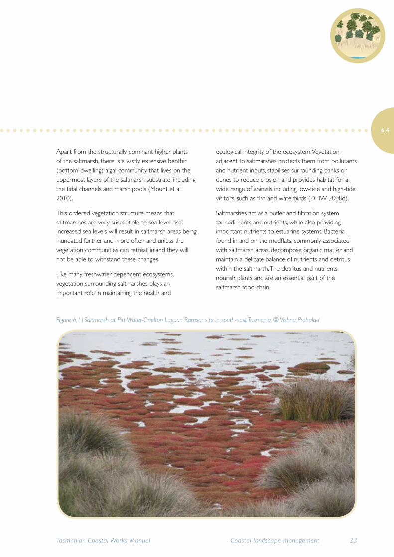
6.4.5 Saltmarsh
Saltmarshes are wetland-like areas associated with estuaries that contain communities of plants and animals that can tolerate high soil salinity and periodic inundation by marine or brackish water.
Coastal saltmarshes are dynamic ecosystems which support highly specialised flora and fauna species and provide temporary habitat for numerous other species (such as shorebirds) which use saltmarshes opportunistically, regularly or sporadically.
Saltmarshes are important habitats, which provide essential feeding, roosting and breeding areas for a large variety of birds, particularly migratory species. These intertidal areas are also important nursery areas for a range of marine organisms (DPIW 2008d).
Saltmarshes are influenced by tidal movement and therefore are generally located within estuaries and along the high tide zones of low-energy coastlines. Saltmarshes should be considered as part of the estuary system and managed with the estuary as a whole.
The tidal regime controls both the salinity and level of inundation and as such is the most important factor influencing saltmarsh character (DPIW 2008d). Saltmarshes also receive freshwater inputs and hence are affected by land and catchment activities (DPIW 2008d).
Saltmarsh often exhibits distinct vegetation zonation. Saline areas of saltmarsh at lower tide levels are dominated by succulent herbs and shrubs such as samphire or beaded glasswort (Sarcocornia quinqueflora). Tidal creeks and freshwater streams cut through the saltmarsh, supporting the mildly salt-tolerant rushes, grasses and sedges which act as the water-filtration system, and in the higher tide regions non-succulent herbs survive.
Tasmanian Coastal Works Manual22 Coastal landscape management
6.4
Apart from the structurally dominant higher plants of the saltmarsh, there is a vastly extensive benthic (bottom-dwelling) algal community that lives on the uppermost layers of the saltmarsh substrate, including the tidal channels and marsh pools (Mount et al. 2010).
This ordered vegetation structure means that saltmarshes are very susceptible to sea level rise. Increased sea levels will result in saltmarsh areas being inundated further and more often and unless the vegetation communities can retreat inland they will not be able to withstand these changes.
Like many freshwater-dependent ecosystems, vegetation surrounding saltmarshes plays an important role in maintaining the health and
ecological integrity of the ecosystem. Vegetation adjacent to saltmarshes protects them from pollutants and nutrient inputs, stabilises surrounding banks or dunes to reduce erosion and provides habitat for a wide range of animals including low-tide and high-tide visitors, such as fish and waterbirds (DPIW 2008d).
Saltmarshes act as a buffer and filtration system for sediments and nutrients, while also providing important nutrients to estuarine systems. Bacteria found in and on the mudflats, commonly associated with saltmarsh areas, decompose organic matter and maintain a delicate balance of nutrients and detritus within the saltmarsh. The detritus and nutrients nourish plants and are an essential part of the saltmarsh food chain.
Tasmanian Coastal Works Manual 23Coastal landscape management
6.4
Figure 6.11Saltmarsh at Pitt Water-Orielton Lagoon Ramsar site in south-east Tasmania. © Vishnu Prahalad
The specialised qualities of saltmarsh vegetation mean that saltmarsh areas support many unique and threatened species. Silky wilsonia (Wilsonia humilis) forms mats of grey amongst other saltmarsh vegetation, and is listed as rare under the Tasmanian Threatened Species Protection Act 1995.
Several saltmarshes in Tasmania have decreased in area. In the south-east, in Pitt Water and South Arm areas, 17ha (5% since the 1970s) were lost due to coastal erosion. The saltmarsh shorelines have eroded at about 6cm to 20cm a year, with erosion highest on the shorelines more exposed to wind-generated waves. Nearly 31ha of saltmarshes in the area were lost due to land reclamation (Prahalad 2009).
In the north-west of Tasmania (west of Stanley), levees or embankments have been built over 21km (about 20%) of the shoreline, reclaiming land from saltmarsh. While the exact area of saltmarsh lost is yet to be ascertained, these levees have no doubt had a major impact on saltmarsh extent in the area (Mount et al. 2010).
6.4.6 Threats to coastal wetlands and saltmarsh
Traditionally saltmarsh and wetlands (in particular ephemeral wetlands) have been undervalued and perceived as wasteland. Many have suffered from direct drainage or alterations to water flows upstream and are also subject to pollution from catchments, urban developments, and localised activities.
Wetlands are threatened by changes to water quality through pollution or sediment, increases in nutrients from freshwater runoff; changes to water regimes; introduction of weeds and removal or loss of native vegetation. These human processes all have impacts on wetland health.
Loss of vegetation communities destroys habitat for both terrestrial and aquatic species such as migratory birds and fish, and has implications for biodiversity and threatened species. Removal of fringing vegetation can further reduce habitat quality by exposing the marsh to other human impacts such as weed invasion and pollution due to increased temperature, light and noise (Prahalad in Mount et al. 2010).
Excess nutrients in wetlands can cause increased occurrences of algal blooms and encourage aquatic weed invasion. This in turn can reduce the biodiversity of the wetland and the capacity to filter water.
Certain land practices associated with intensive animal production and agriculture, both within the wetland and upstream in the catchment, are extremely destructive to coastal wetlands. Drainage for agriculture, removal of water for irrigation, damming to retain water for irrigation, nutrient runoff, stock grazing and land clearing (vegetation removal) all threaten wetland values and ecosystems.
Saltmarshes are vulnerable to clearing and land reclamation for coastal housing and industrial developments. They are often considered wastelands and ideal sites for rubbish dumps. Landfill directly affects the flora and fauna of the saltmarsh through the destruction of habitat and can also influence hydrology, physical structure and water quality of the saltmarsh (DPIW 2008d).
The construction of roads and tracks within saltmarshes can be detrimental to the ecology, through the physical effects of excavation, pollutants that enter the saltmarsh via runoff and restriction of tidal/water flow within the saltmarsh area (DPIW 2008d).
While roads and tracks adjacent to saltmarshes are not considered to be as damaging to saltmarshes as those constructed within the ecosystem, they can still
Tasmanian Coastal Works Manual24 Coastal landscape management
6.4
restrict in-flowing water movement and contribute to pollutants and sediment entering the saltmarsh via runoff (DPIW 2008d).
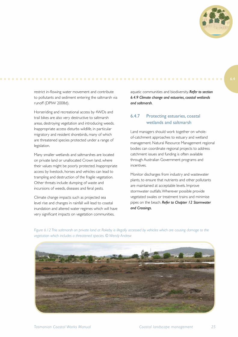
Horseriding and recreational access by 4WDs and trail bikes are also very destructive to saltmarsh areas, destroying vegetation and introducing weeds. Inappropriate access disturbs wildlife, in particular migratory and resident shorebirds, many of which are threatened species protected under a range of legislation.
Many smaller wetlands and saltmarshes are located on private land or unallocated Crown land, where their values might be poorly protected. Inappropriate access by livestock, horses and vehicles can lead to trampling and destruction of the fragile vegetation. Other threats include dumping of waste and incursions of weeds, diseases and feral pests.
Climate change impacts such as projected sea level rise and changes in rainfall will lead to coastal inundation and altered water regimes which will have very significant impacts on vegetation communities,
aquatic communities and biodiversity. Refer to section 6.4.9 Climate change and estuaries, coastal wetlands and saltmarsh.
6.4.7 Protecting estuaries, coastal wetlands and saltmarsh
Land managers should work together on whole-of-catchment approaches to estuary and wetland management. Natural Resource Management regional bodies can coordinate regional projects to address catchment issues and funding is often available through Australian Government programs and incentives.
Monitor discharges from industry and wastewater plants, to ensure that nutrients and other pollutants are maintained at acceptable levels. Improve stormwater outfalls. Wherever possible provide vegetated swales or treatment trains and minimise pipes on the beach. Refer to Chapter 12 Stormwater and Crossings.
Tasmanian Coastal Works Manual 25Coastal landscape management
6.4
Figure 6.12 This saltmarsh on private land at Rokeby is illegally accessed by vehicles which are causing damage to the vegetation which includes a threatened species. © Wendy Andrew
Ensure that saltmarsh communities are valued for their uniqueness and the role they play in our coastal ecosystem. Retain any existing areas of wetland and saltmarsh in an undisturbed condition. Often the best management practice is to ‘leave alone’. Do not drain saltmarsh areas or allow soil or other material to be dumped there.
Establish buffer zones around saltmarsh and wetland areas of at least 200m, to protect against influx of nutrients and pollutants.
Avoid building drains or levees that alter drainage patterns, direct fluids and waste into wetland or saltmarsh areas, or act as barriers that prevent saltmarsh migrating inland with sea level rise.
Control access and keep horses, livestock and recreational vehicles out of saltmarsh areas. Fencing
will not only control access but may also prevent dumping of soil, rubbish and chemicals.
Monitoring of saltmarsh is essential to determine the current health of saltmarsh communities and to ensure that land managers and specialists are alerted to any changes or degradation.
Use signage and information sheets or brochures to educate the local community about saltmarsh values. Work in collaboration with local community groups when developing signs and informative material.
The Private Land Conservation Program aims to develop and encourage an integrated approach to private land management and planning that helps landowners to fully benefit from the sustainable management of their properties’ natural diversity. The program promotes high-level recognition of
Tasmanian Coastal Works Manual26 Coastal landscape management
6.4
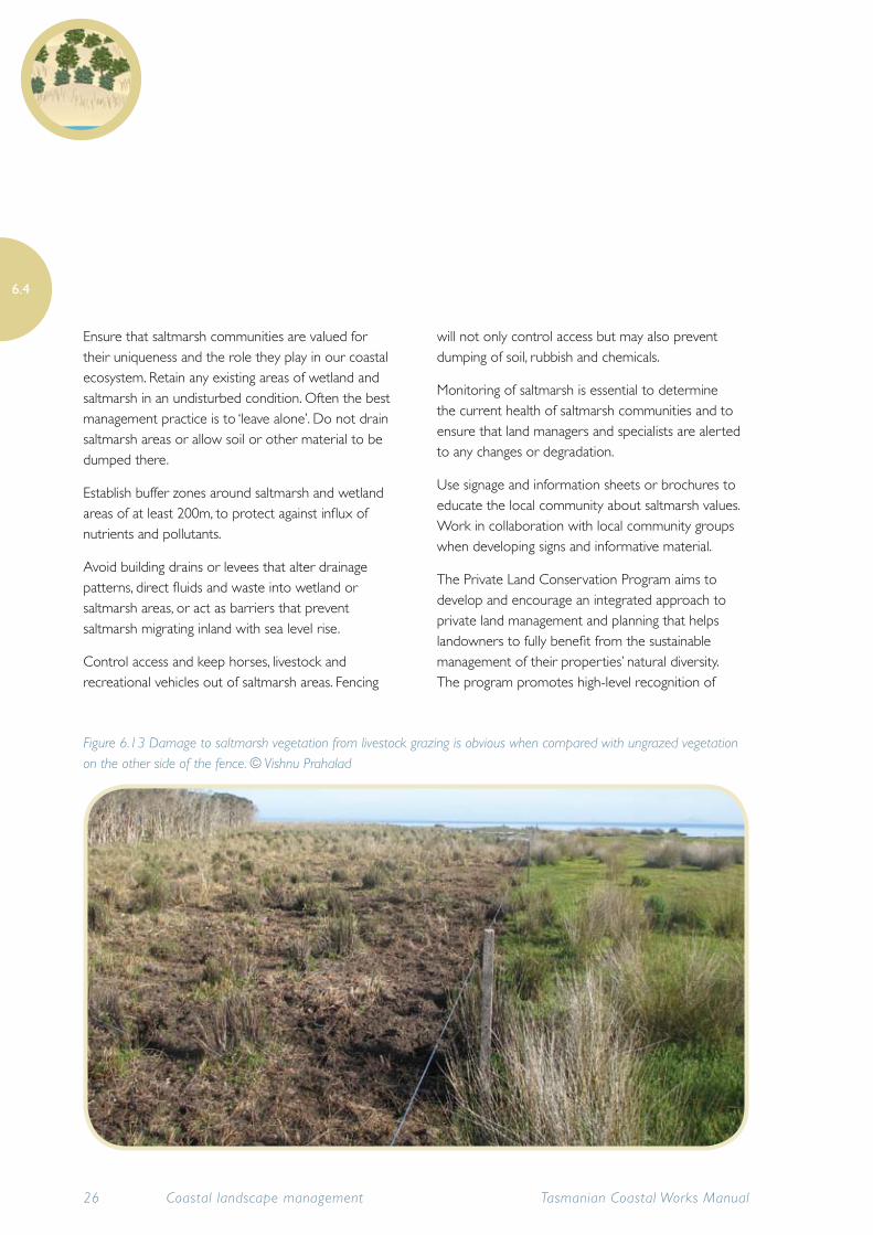
Figure 6.13 Damage to saltmarsh vegetation from livestock grazing is obvious when compared with ungrazed vegetation on the other side of the fence. © Vishnu Prahalad
the biodiversity values of natural systems and the need to appropriately protect them, and supports individuals who voluntarily manage these systems for conservation outcomes. Conservation covenants can be an effective way to protect wetland values on private land. More information is available from DPIPWE.
6.4.8 Guidelines for working in coastal wetlands and saltmarshes
Sometimes it is necessary to undertake works in fragile wetland and saltmarsh areas to remove weeds or rubbish, erect fencing or undertake more comprehensive rehabilitation of wetland values.
Always seek specialist advice before planning or undertaking works and ensure that you have identified all the natural and cultural values that you need to protect during your activity.
Avoid using machinery in wetland and saltmarsh areas as the vegetation is easily destroyed and is extremely difficult and expensive to rehabilitate. You can also introduce weeds and waterborne diseases and pathogens. If you must use machinery, seek specialist advice and use operators with environmental credentials.
Ensure that you adequately control any soil and runoff from works adjacent to wetlands and saltmarsh. Monitor water quality before and after works to determine if there has been any impact.
Avoid using herbicides in wetland areas or near waterways. If herbicide must be used, consult the Department of Primary Industry, Parks, Water and Environment (DPIPWE) weed specialists and be sure to choose one that is approved for use around waterways. Herbicides cause pollution, expose the soil to erosion and kill frogs and other animals (avoid
spraying in their breeding seasons).
Follow the DPIPWE Codes of Practice, Guidelines and Information Sheets for using herbicides, which can be found at the DPIPWE biosecurity website.
When mowing or slashing, ensure that slashed material is removed and does not get into the waterway. Sometimes it is safe to spread slashed material on-site away from the waterway but only if it does not contain ripe weed seeds. Refer to Chapter 7 Vegetation management.
6.4.9 Climate change and estuaries, coastal wetlands and saltmarsh
The ability of estuarine and wetland systems to respond to the threat of sea level rise depends on their current condition. If they are healthy and resilient, they will be able to respond more strongly; weakened, threatened and pressured habitats will succumb to sea level rise more readily (Prahalad in Mount et al. 2010).
Current IPCC projections of sea level rise will result in inundation of low-lying wetland and saltmarsh areas. Changes to rainfall will result in altered water regimes which further complicate the situation.
Altered salinity, sediment inputs and nutrient loadings are all likely to put estuarine-dependent species under threat. Inundation of low-lying areas around Tasmanian estuaries could affect saltmarshes, wetlands and intertidal sandflats – important wading bird habitat (DPIPWE 2010).
Other concerns include changes in estuarine fisheries and habitats, and increased vulnerability to marine pests and weeds (DPIPWE 2010).
Specialised saltmarsh vegetation will need space (refugia) to colonise inland to remain within its
Tasmanian Coastal Works Manual 27Coastal landscape management
6.4
optimal tidal range. These communities can migrate landwards if the topography permits and there are no obstacles such as roads or seawalls. If these unique and important wetland areas are to survive, land managers will need to provide opportunities and space for the saltmarsh to encroach inland wherever possible.
Land managers should seek expert advice about where local saltmarsh communities might retreat to. Modelling of future sea level rise in local areas using a high-resolution digital elevation model such as LiDAR (light detection and ranging) mapping, is a useful means of identifying potential saltmarsh migration pathways and refugia. LiDAR data and basic overlays
can be viewed on the LIST.
Often barriers such as roads prevent the movement of saltmarsh and wetland communities landward. In some areas it may be possible to provide culverts under roads or other shoreline infrastructure in order to enable wetland areas to retreat.
The future extent and migration pathways of tidal wetlands in the Derwent Estuary, in the event of projected future sea level rise, has been predicted in The future of the Derwent Estuary saltmarshes and tidal freshwater wetlands in response to sea level rise (Prahalad et al. 2009). The current extent of all tidally influenced wetlands and saltmarshes and their immediately adjacent freshwater wetlands were mapped (though not verified on the ground) and then the entire estuary was analysed with inundation modelling using the best available sea level rise projections for the year 2100.
Tasmanian Coastal Works Manual28 Coastal landscape management
6.4
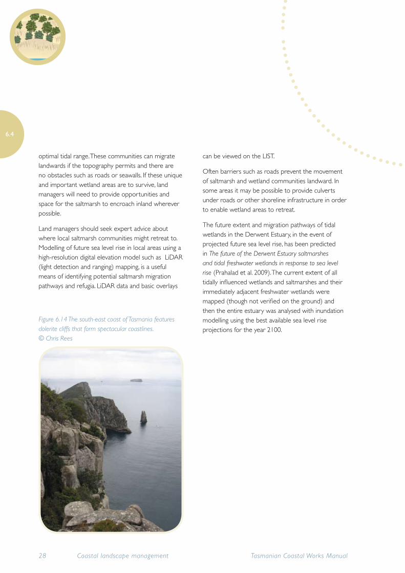
Figure 6.14 The south-east coast of Tasmania features dolerite cliffs that form spectacular coastlines. © Chris Rees
6.5 Rocky shores
This section describes the formations of rocky coastal landscapes in Tasmania. Where the coast is exposed to the forces of the ocean, soft sediments can be removed and the bedrock directly eroded by the sea. In such areas sea cliffs and sea-stacks are common.
Much of the south-western coast from Cape Sorell to South East Cape is like this, as are parts of the south-eastern coasts of south Bruny Island, the Tasman Peninsula, Maria Island and Freycinet Peninsula.
Given appropriate conditions, other formations may include sea caves, rock arches and wave-cut platforms, examples of all of which are seen on the Tasman Peninsula.
More resistant zones of bedrock gradually wear away to form rocky reefs offshore. Rocky reefs provide important habitat for marine communities.
Rocky shore often provide rocky intertidal habitat that can support a complex assemblage of marine invertebrates. Many sessile (non-moving) invertebrate species such as ascidians (seasquirts) and sea anemones require a rocky substrate to attach to. Other invertebrates such as seastars, urchins and many molluscs (snails) live on rocky shorelines and shelter in crevices and scrape algae off the rocks. Rocky outcrops and headlands are important roosting spots for seabirds such as cormorants and gulls, and rocky intertidal areas are important foraging areas.
Rocky shorelines are least likely to show major effects of climate change but rising seas will submerge wave platforms and intertidal rocky habitats, which may affect intertidal marine assemblages.
Hard-rock coastlines are, in general, likely to show only negligible change through coastal erosion within human lifetimes. Some hard-rock shores in
Tasmanian Coastal Works Manual 29Coastal landscape management
6.5
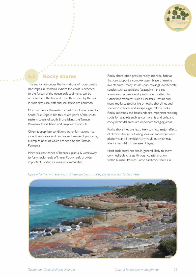
Figure 6.15 The north-east coast of Tasmania boasts striking granite outcrops. © Chris Rees
Tasmania have shore platforms 10m to 20m wide, which is indicative of the limited amount of erosion they have undergone over the last 6500 years while the sea has been roughly at its present level. Gently to moderately sloping hard-rock coasts are the safest places for near-shore coastal development, including residences, as in most cases they are likely to experience only minimal erosion or flooding from projected sea level rise over the next few centuries. Sloping hard-rock shores comprise about 20% of Tasmania’s coastal length (Sharples 2006) and are common in the Hobart region and along parts of the east, north and west coasts.
However, steep coastal slopes and vertical sea cliffs in hard rock may exhibit increased instability through rock falls and slumping, especially where most exposed to high wave energy or where composed of intensely fractured bedrock, as is the case with many Tasmanian sea cliffs of Permian-age siltstone bedrock. Hard-rock sea cliffs comprise a further 20% of Tasmania’s coastal length (Sharples 2006) and areas near their edges are generally less suitable for development.
Although hard-rock coasts are generally the safest for development, any plans for development in such locations should consider the nature, slope, fracturing and stability of the bedrock, as some locations will have potential for slumping and instability.
6.6 Soft-rock shores
This section describes soft-rock sediment types in Tasmania, which are more prone to erosion. Management issues and techniques for these shorelines are described in Chapter 15 Shoreline modification.
Although there are many hard-rock coastlines in Tasmania, certain bedrock types are relatively soft and more prone to erosion than hard rock, albeit less rapidly responsive to erosion than soft unconsolidated sandy and muddy shores. These soft (semi-consolidated) rock coastlines do not recover from erosion events in the way that sandy shores and dune systems can, as they are composed of significant proportions of clay and/or cobble material which, once eroded, is not returned by fair-weather swells to rebuild the shorelines in the way that occurs on sandy coasts.
Many of these soft-rock shores have been slowly but progressively eroding throughout the last 6500 years while sea level has been stable at roughly its present level, and their rate of erosion is likely to increase with future sea level rise. In contrast to hard-rock shores, soft-rock shores typically exhibit noticeable change through erosion, within a human lifetime.
The most important soft-rock shore types in Tasmania are those formed in Tertiary-age clays, soft sandstones and clayey gravels, although shores formed in slumped deposits of basalt debris are another important type. Examples of soft-rock coastlines in Tasmania whose erosion is currently threatening roads and houses include those in the Margate-to-Coningham region and along parts of the Taroona coast south of Hobart, at Parnella near St Helens, at Ansons Bay and in a number of locations in the Tamar Estuary.
Long term erosion of soft-rock cliffs also characterise the northern shore of Macquarie Harbour, although
Tasmanian Coastal Works Manual30 Coastal landscape management
6.6
there is little infrastructure or development at risk there. Basaltic debris (ancient landslides) also form soft-rock shores along parts of the north coast between Devonport and Stanley, including key locations such as Boat Harbour.
On open coasts the higher wave energy has mostly already eroded shorelines to a point where they have become buried under sandy deposits and form sandy coastlines. But often, in comparatively sheltered inlets and embayments, less energetic locally generated wind waves are still progressively eroding the shore and in some cases are already putting infrastructure at risk in some areas mentioned above.
6.6.1 Climate change and soft-rock shores
Soft-rock shores with a lower gradient are mostly prone to simple progressive erosion and recession; however, many of these shores form steep-to-cliffed shores (as at Taroona and Parnella), and these are prone to occasional slumps and block-slides. Soft-rock shores may present a range of management issues in light of climate change and sea level rise, since the rise in sea level – and hence increased frequency of wave attack – means that the rate of erosion and slumping of these shores is likely to increase.
Soft-rock coastlines are increasingly being considered an early indicator of climate change impacts, as the early effects such as increased rates of erosion are not masked by the erosion-accretion cycles characteristic of sandy shores.
Tasmanian Coastal Works Manual 31Coastal landscape management
6.6
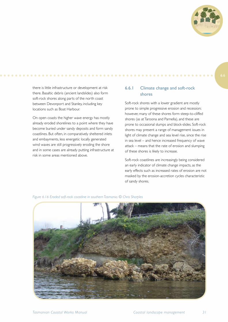
Figure 6.16 Eroded soft-rock coastline in southern Tasmania. © Chris Sharples
Because of the inability of soft sediment coastlines to rebuild themselves after erosion, land managers will need to assess for which areas shoreline protection works are suitable and viable and which areas should be allowed to recede and find a natural equilibrium. It may be deemed necessary to undertake shoreline protection works such as revetments to protect infrastructure assets of high community value.
The location of soft-rock shorelines predominantly in sheltered waters of estuaries means that they are already under pressure from a range of human developments and uses. It is increasingly important to protect remaining natural areas and values from human impacts, because climate change and sea level rise will increase stresses on these environments, making it harder for the associated ecosystems to adapt.
In many cases it will be preferable to allow soft-rock shores to erode, allowing the associated landforms and ecosystems to migrate landwards as sea level rise moves the shores.
6.6.2 Erosion control on soft-rock shores
Soft-rock shorelines need to be monitored regularly for new erosion events and hazardous damage. The monitoring program should include checks after storm events, particularly in high use areas where damage could be dangerous to the public.
Maintaining or re-establishing native vegetation along the foreshore may help to stabilise the bank. Areas where lawn has been encouraged to grow to the water’s edge are highly susceptible to erosion due to the lack of substantial root systems. Restoring native vegetation may improve shoreline stability but in some cases large trees can be undermined by shoreline erosion and will actually exacerbate the problem when they eventually topple, pulling large clumps of bank with them.
Seek expert advice before undertaking any revegetation work to attempt to stabilise these types of shorelines.
If possible, it is best to allow the shoreline to recede until naturally stabilised but in some instances it may be necessary to artificially stabilise the shoreline. There is a range of temporary and permanent shoreline stabilisation techniques; all need to be planned carefully in consultation with geomorphologists, coastal engineers and other coastal specialists, and will incur initial and ongoing (maintenance) costs.
As is the case with other types of coastal erosion, it is important to recognise that under-engineered protection works are likely to rapidly fail. Any works intended to stop erosion of soft-rock shores need to be well designed and robustly constructed. In most cases this will mean creating a mostly artificial shoreline.
Refer to Chapter 15 Shoreline modification.
32 Tasmanian Coastal Works ManualCoastal landscape management
6.6
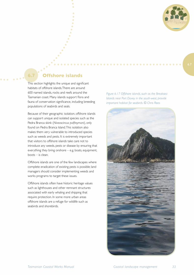
6.7 Offshore islands
This section highlights the unique and significant habitats of offshore islands. There are around 600 named islands, rocks and reefs around the Tasmanian coast. Many islands support flora and fauna of conservation significance, including breeding populations of seabirds and seals.
Because of their geographic isolation, offshore islands can support unique and isolated species such as the Pedra Branca skink (Niveoscincus palfreymani), only found on Pedra Branca Island. This isolation also makes them very vulnerable to introduced species such as weeds and pests. It is extremely important that visitors to offshore islands take care not to introduce any weeds, pests or disease by ensuring that everything they bring onshore – e.g. boats, equipment, boots – is clean.
Offshore islands are one of the few landscapes where complete eradication of existing pests is possible; land managers should consider implementing weeds and works programs to target these issues.
Offshore islands often have historic heritage values such as lighthouses and other remnant structures associated with early whaling and shipping that require protection. In some more urban areas offshore islands are a refuge for wildlife such as seabirds and shorebirds.
Tasmanian Coastal Works Manual 33Coastal landscape management
6.7
Figure 6.17 Offshore islands, such as the Breaksea Islands near Port Davey in the south-west, provide important habitat for seabirds. © Chris Rees
6.8 Tools and resources
Complete details of all printed publications listed here are provided in a reference list at the end of the Manual. Other tools and resources including websites are collated in Appendix 5.
A Wetlands strategy for Tasmania (DPIWE 2004a)
Aboriginal Heritage Tasmania
Desktop searches for Aboriginal heritage sites
www.aboriginalheritage.tas.gov.au
Coastal dune management: A manual of coastal dune management and rehabilitation techniques (NSW Department of Land and Water Conservation 2001)
Coastal values data
Vegetation, species habitat and geomorphic values data for a 100m-wide coastal strip of the northern, southern and north-western Tasmania NRM Regions. Available on the LIST.
www.thelist.tas.gov.au
Conservation of freshwater ecosystem values (CFEV) project: Technical report (DPIW 2008d) Information on Tasmania’s wetlands and their conservation values, developed within DPIPWE as part of the Conservation of Freshwater Ecosystem Values Project. Web-based information is available through Water Information Systems Tasmania
www.dpipwe.tas.gov.au Go to Water > CFEV program > CFEV resources or
http://waterplanning.org.au/news/conservation-of-freshwater-ecosystems-values-project
DPIPWE biosecurity website
Codes of practice, guidelines and information sheets for using herbicides
www.dpipwe.tas.gov.au
Estuary entrance management support system (Arundel 2006)
Foreshore values mapping
Provides baseline information on the condition of foreshores and identifies pressures for measuring impacts on key marine and coastal ecosystems. Available on the LIST.
www.thelist.tas.gov.au
Indicative mapping of Tasmanian coastal vulnerability to climate change and sea level rise (Sharples 2006)
Keeping it clean: A Tasmanian field hygiene manual to prevent the spread of freshwater pests and pathogens (Allan & Gartenstein 2010)
http://www.nrmsouth.org.au/uploaded/287/15130799_22keepingitcleanweb.pdf
Natural Values Atlas
Provides authoritative, comprehensive information on Tasmania’s natural values. To access, download a free registration form from the website
https://www.naturalvaluesatlas.tas.gov.au
34 Tasmanian Coastal Works Manual
6.8
Coastal landscape management
Private Land Conservation Program
www.dpipwe.tas.gov.au Go to managing our natural resources > the private land conservation program
Rivercare guideline for the use of herbicides near waterways and wetlands
www.dpipwe.tas.gov.au Go to food and agriculture > Agricultural & Veterinary Chemicals > Codes of Practice & Guidelines
Saltwater wetlands rehabilitation manual. (Department of Environment and Climate Change NSW 2008b)
Smartline or coastal vulnerability maps
Maps of coastal landform types and their vulnerability to sea level rise can be found under ‘Climate Change’ layers on the LIST and the OzCoasts website. The data is presented as a ‘smart line’ following the coastline, with information on the geology of the coast readily interpreted for particular coastal areas.
www.thelist.tas.gov.au
www.ozcoasts.org.au
The coast of Australia (Short & Woodroffe 2009)
The future of the Derwent Estuary saltmarshes and tidal freshwater wetlands in response to sea level rise (Prahalad et al. 2009)
Waterways and wetlands works manual: Environmental best practice guidelines for undertaking works in waterways and wetlands in Tasmania (Gallagher 2003)
Tasmanian Coastal Works Manual 35Coastal landscape management
6.7

Tasmanian Coastal Works Manual36 Coastal landscape management