Embed Size (px)
Citation preview
Coastal Impacts, Adaptation, and Vulnerabilities
A Technical Input to the 2013 National Climate Assessment
National Climate Assessment Regional Technical Input Report Series
Edited by:
Virginia Burkett
Margaret Davidson


Coastal Impacts, Adaptation, and Vulnerabilities
A Technical Input to the 2013 National Climate Assessment
© 2012 The National Oceanic and Atmospheric Administration
All rights reserved under International and Pan-American Copyright Conventions. Reproduction of this report by electronic means for personal and noncommercial purposes is permitted as long as proper acknowledgement is included. Users are restricted from photocopying or mechanical reproduction as well as creating derivative works for commercial purposes without the without the prior written permission of the publisher.
ISLAND PRESS is a trademark of the Center for Resource Economics.
Printed on recycled, acid-free paper
Manufactured in the United States of America
Suggested Citation: Burkett, V.R. and Davidson, M.A. [Eds.]. (2012). Coastal Impacts, Adaptation and Vulnerability: A Technical Input to the 2012 National Climate Assessment. Cooperative Report to the 2013 National Climate Assessment, pp. 150.
Keywords: Climate change, climate variability, coasts, coastal region, coastal inundation, sea-level rise, adaptation, climate risks, extreme events, climate change indicators, decision making, vulnerability, mitigation, coastal ecosystems, sea surface temperature, precipitation, ocean waves, ocean circulation patterns, coastal erosion, flooding, saltwater intrusion, social vulnerability
This Technical Input was produced by a team of experts at the request of the NCA Development and Advisory Committee. It will be available for use as reference material by all NCA author teams.
The scientific results and conclusions, as well as any views or opinions expressed herein, are those of the author(s) and do not necessarily reflect the views of NOAA or the Department of Commerce.
Date Submitted to the NCA Development and Advisory Committee:October 12, 2012
Editorial Support:The Stiefel Group
Technical Input Coordinating Lead Author Contact Information:Virginia Burkett: [email protected] Davidson: [email protected]
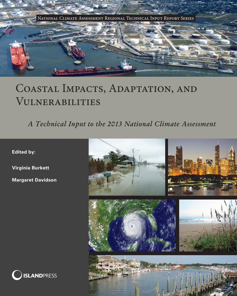
Front Cover Images: Courtesy of National Oceanic and Atmospheric Administration
About This Series
This report is published as one of a series of technical inputs to the National Climate Assessment (NCA) 2013 report. The NCA is being conducted under the auspices of the Global Change Research Act of 1990, which requires a report to the President and Con-gress every four years on the status of climate change science and impacts. The NCA in-forms the nation about already observed changes, the current status of the climate, and anticipated trends for the future. The NCA report process integrates scientific informa-tion from multiple sources and sectors to highlight key findings and significant gaps in our knowledge. Findings from the NCA provide input to federal science priorities and are used by U.S. citizens, communities and businesses as they create more sustainable and environmentally sound plans for the nation’s future.
In fall of 2011, the NCA requested technical input from a broad range of experts in academia, private industry, state and local governments, non-governmental organiza-tions, professional societies, and impacted communities, with the intent of producing a better informed and more useful report in 2013. In particular, the eight NCA regions, as well as the Coastal and the Ocean biogeographical regions, were asked to contribute technical input reports highlighting past climate trends, projected climate change, and impacts to specific sectors in their regions. Each region established its own process for developing this technical input. The lead authors for related chapters in the 2013 NCA report, which will include a much shorter synthesis of climate change for each region, are using these technical input reports as important source material. By publishing this series of regional technical input reports, Island Press hopes to make this rich collection of information more widely available.
This series includes the following reports:
Climate Change and Pacific Islands: Indicators and ImpactsCoastal Impacts, Adaptation, and VulnerabilitiesGreat Plains Regional Technical Input ReportClimate Change in the Midwest: A Synthesis Report for the National Climate AssessmentClimate Change in the Northeast: A Sourcebook Climate Change in the Northwest: Implications for Our Landscapes, Waters, and CommunitiesOceans and Marine Resources in a Changing ClimateClimate of the Southeast United States: Variability, Change, Impacts, and VulnerabilityAssessment of Climate Change in the Southwest United States
Electronic copies of all reports can be accessed on the Climate Adaptation Knowledge Exchange (CAKE) website at www.cakex.org/NCAreports. Printed copies are available for sale on the Island Press website at www.islandpress.org/NCAreports.


Coastal Impacts, Adaptation, and Vulnerabilities
A Technical Input to the 2013 National Climate Assessment
CoordInATIng LeAd AuThorS
Virginia Burkett u.S. geological Survey
Margaret Davidson national oceanic and Atmospheric Administration
Washington | Covelo | London

Authors
Chapter 1
Lead author: Mary Culver, National Oceanic and atmospheric administration
Britta Bierwagen, U.S. Environmental Protection Agency
Virginia Burkett, U.S. Geological Survey
Ralph Cantral, National Oceanic and Atmospheric Administration
Margaret A. Davidson, National Oceanic and Atmospheric Administration
Hilary Stockdon, U.S. Geological Survey
Chapter 2
Lead author: S. Jeffress Williams, U.S. Geological Survey
David Atkinson, University of Victoria
Aaron R. Byrd, U.S. Army Corps of Engineers
Hajo Eicken, University of Alaska
Timothy M. Hall, National Oceanic and Atmospheric Administration
Thomas G. Huntington, U.S. Geological Survey
Yongwon Kim, University of Alaska
Thomas R. Knutson, National Oceanic and Atmospheric Administration
James P. Kossin, National Oceanic and Atmospheric Administration
Michael Lilly, GW Scientific
John J. Marra, National Oceanic and Atmospheric Administration
Jayantha Obeysekera, South Florida Water Management District
Adam Parris, National Oceanic and Atmospheric Administration
Jay Ratcliff, U.S. Army Corps of Engineers
Thomas Ravens, University of Alaska
Don Resio, University of North Florida
Peter Ruggiero, Oregon State University
E. Robert Thieler, U.S. Geological Survey
James G. Titus, U.S. Environmental Protection Agency
Ty V. Wamsley, U.S. Army Corps of Engineers

Chapter 3
Lead author: Carlton h. hershner, Jr., Virginia Institute of Marine Science
Grant Ballard, PRBO Conservation Science
Donald R. Cahoon, U.S. Geological Survey
Robert Diaz, Virginia Institute of Marine Science
Tom Doyle, U.S. Geological Survey
Neil K. Ganju, U.S. Geological Survey
Glenn Guntenspergen, U.S. Geological Survey
Robert Howarth, Cornell University
Hans W. Paerl, University of North Carolina
Charles “Pete” H. Peterson, University of North Carolina
Julie D. Rosati, U.S. Army Corps of Engineers
Hilary Stockdon, U.S. Geological Survey
Robert R. Twilley, Louisiana State University
Jordan West, U.S. Environmental Protection Agency
Chapter 4
Lead author: tony MacDonald, Monmouth University
Austin Becker, Stanford University
Doug Bellomo, Federal Emergency Management Agency
Virginia Burkett, U.S. Geological Survey
Janet Cikir, National Park Service
Susan L. Cutter, University of South Carolina
Kirsten Dow, University of South Carolina
John A. Hall, U.S. Department of Defense
Maria G. Honeycutt, National Oceanic and Atmospheric Administration
Philip G. King, San Francisco State University
Paul H. Kirshen, University of New Hampshire
Jim London, Clemson University
Aaron McGregor, California Ocean Science Trust
Jeffrey A. Melby, U.S. Army Corps of Engineers
Lindene Patton, Zurich Insurance Group, Ltd.
Edmond J. Russo, U.S. Army Corps of Engineers
Gavin Smith, University of North Carolina
Cindy Thatcher, U.S. Geological Survey
Juli M. Trtanj, National Oceanic and Atmospheric Administration
Chapter 5
Lead author: Lara hansen, ecoadapt
Rebecca Beavers, National Park Service
Jeff Benoit, Restore America’s Estuaries
Diana Bowen, Coastal States Organization
Ellie Cohen, PRBO Conservation Science
Michael Craghan, U.S. Environmental Protection Agency
Steve Emmett-Mattox, Restore America’s Estuaries
Zach Ferdana, The Nature Conservancy
Kristen Fletcher, Coastal States Organization
Stephen Gill, National Oceanic and Atmospheric Administration
Jessica Grannis, Georgetown University
Rachel M. Gregg, EcoAdapt
Jennie Hoffman, EcoAdapt
Brian Holland, ICLEI – Local Governments for Sustainability
Zoe Johnson, Maryland Department of Natural Resources
Benjamin L. Preston, Oak Ridge National Laboratory
Doug Marcy, National Oceanic and Atmospheric Administration
James Pahl, Coastal Protection and Restoration Authority of Louisiana
Richard Raynie, Coastal Protection and Restoration Authority of Louisiana
John Rozum, National Oceanic and Atmospheric Administration/NatureServe
Chapter 6
Lead author: S. Jeffress Williams, U.S. Geological Survey
CaSe StUDy
Lead authors: Susan Julius, U.S. environmental protection agency (Chesapeake Bay) and Denise J. reed, University of New Orleans (Gulf of Mexico)


Acknowledgements
STeerIng CoMMITTee
Virginia Burkett (Co-Chair), U.S. Geological SurveyMargaret Davidson (Co-Chair), National Oceanic and Atmospheric AdministrationRalph Cantral, National Climate AssessmentJohn Haines, U.S. Geological SurveyJohn Hall, U.S. Department of DefenseFred Lipschultz, National Climate AssessmentAnne Waple, National Oceanic and Atmospheric AdministrationJordan West, U.S. Environmental Protection Agency
We would like to thank the U.S. Geological Survey (USGS), the National Oceanic and Atmospheric Administration (NOAA), and the National Aeronautics and Space Administration (NASA) for providing financial resources to support the development of this technical input including personnel, travel, and accommodations for workshop participants.
We thank the U.S. Global Change Research Program (USGCRP) for providing a shared online workspace as well as technical support during phone and web-based meetings. We are grateful to Susanne Moser (Susanne Moser Research & Consulting) and Richard Moss (University of Maryland) for giving presentations during the workshop. We appreciate the constructive comments received from three formal reviewers on the entire technical input and several external reviewers on individual chapters during the preparation. We are deeply grateful to The Stiefel Group (Murielle Gamache-Morris and Emily Wallace) for their skillful edits and the organizational support they provided to the writing team.


ContentsKey Terms xviiiAcronyms xxCommunicating Uncertainty xxiiExecutive Summary xxiii
Chapter 1: INtrODUCtION aND CONtext 1
1.1 Scope and Purpose 11.2 Linkages and Overlapping Topics of the NCA 21.3 Reliance on the Coastal Zone 4 Increasing Population and Changing Land Use 4 Changing Coastal Economy 6 Resilience on Coastal Ecosystems 7 Maintaining a Balance 8
Chapter 2: phySICaL CLIMate FOrCeS 10
2.1 Overview of Climate and Sea-level-rise Effects on Coasts 12 Introduction 12 Coastal Landforms and Coastal Change 14 Sea-level Rise and Effects on Coasts 15 Inundation, Land Loss, and Land Area Close to Present Sea Level 16 Historic to Present-day Sea-level Rise 19 Other Coastal Climate Change Trends 19 The Basis for Concern 222.2 Sea-level Rise and Future Scenarios 23 Scenario Planning 23 Global Mean Sea-level Rise Scenarios 24 Key Uncertainties on the Global Sea-level Rise Scenarios 24 Ice Sheet Loss 26 Developing Regional and Local Scenarios 272.3 Extreme Events and Future Scenarios 272.4 Changes in Wave Regimes and Circulation Patterns 31 Wave Regimes 31 Extratropical Storm Waves 32 Tropical Cyclone Generated Waves 34 Impacts 35 Ocean Circulation 362.5 Relative Vulnerability of Coasts 37 Physical Setting 37 Climate and Non-climate Drivers 37 Assessment Results 382.6 Changes in Precipitation Patterns 40
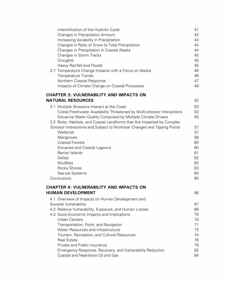
Intensification of the Hydrolic Cycle 41 Changes in Precipitation Amount 42 Increasing Variability in Precipitation 44 Changes in Ratio of Snow to Total Precipitation 44 Changes in Precipitation in Coastal Alaska 44 Changes in Storm Tracks 45 Droughts 45 Heavy Rainfall and Floods 452.7 Temperature Change Impacts with a Focus on Alaska 46 Temperature Trends 46 Northern Coastal Response 47 Impacts of Climate Change on Coastal Processes 49
Chapter 3: VULNerabILIty aND IMpaCtS ON NatUraL reSOUrCeS 52
3.1 Multiple Stressors Interact at the Coast 53 Costal Freshwater Availability Threatened by Multi-stressor Interactions 53 Estuarine Water Quality Comprised by Multiple Climate Drivers 553.2 Biota, Habitats, and Coastal Landforms that Are Impacted by Complex Stressor Interactions and Subject to Nonlinear Changes and Tipping Points 57 Wetlands 57 Mangroves 58 Coastal Forests 60 Estuaries and Coastal Lagoons 60 Barrier Islands 61 Deltas 62 Mudflats 63 Rocky Shores 63 Sea-ice Systems 64Conclusions 65
Chapter 4: VULNerabILIty aND IMpaCtS ON hUMaN DeVeLOpMeNt 66
4.1 Overview of Impacts on Human Development and Societal Vulnerability 674.2 Relative Vulnerability, Exposure, and Human Losses 684.3 Socio-Economic Impacts and Implications 70 Urban Centers 70 Transportation, Ports, and Navigation 71 Water Resources and Infrastructure 73 Tourism, Recreation, and Cultural Resources 74 Real Estate 76 Private and Public Insurance 79 Emergency Response, Recovery, and Vulnerability Reduction 82 Coastal and Nearshore Oil and Gas 84
4.4 Human Health Impacts and Implications 87 Direct Impacts 88 Indirect Impacts 894.5 Implications for Coastal Military Installations and Readiness 92 Coastal Military Installation Climate- and Global-change Challenges 92 Coastal Installation Vulnerabilities and Combat Service Support Readiness 94 Operations and Training Readiness and Natural Resource Impacts 95 DoD Requirements and Programs for Vulnerability and Impact Assessments and Adaptation Planning 96
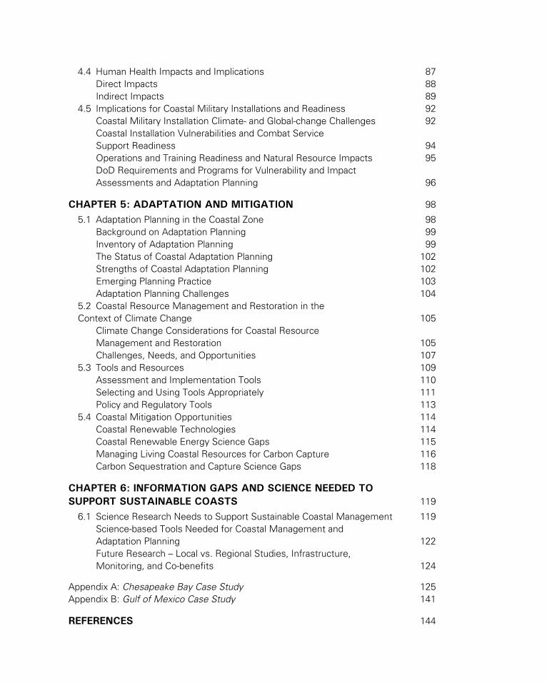
Chapter 5: aDaptatION aND MItIGatION 98
5.1 Adaptation Planning in the Coastal Zone 98 Background on Adaptation Planning 99 Inventory of Adaptation Planning 99 The Status of Coastal Adaptation Planning 102 Strengths of Coastal Adaptation Planning 102 Emerging Planning Practice 103 Adaptation Planning Challenges 1045.2 Coastal Resource Management and Restoration in the Context of Climate Change 105 Climate Change Considerations for Coastal Resource Management and Restoration 105 Challenges, Needs, and Opportunities 1075.3 Tools and Resources 109 Assessment and Implementation Tools 110 Selecting and Using Tools Appropriately 111 Policy and Regulatory Tools 1135.4 Coastal Mitigation Opportunities 114 Coastal Renewable Technologies 114 Coastal Renewable Energy Science Gaps 115 Managing Living Coastal Resources for Carbon Capture 116 Carbon Sequestration and Capture Science Gaps 118
Chapter 6: INFOrMatION GapS aND SCIeNCe NeeDeD tO SUppOrt SUStaINabLe COaStS 119
6.1 Science Research Needs to Support Sustainable Coastal Management 119 Science-based Tools Needed for Coastal Management and Adaptation Planning 122 Future Research – Local vs. Regional Studies, Infrastructure, Monitoring, and Co-benefits 124
Appendix A: Chesapeake Bay Case Study 125Appendix B: Gulf of Mexico Case Study 141
reFereNCeS 144
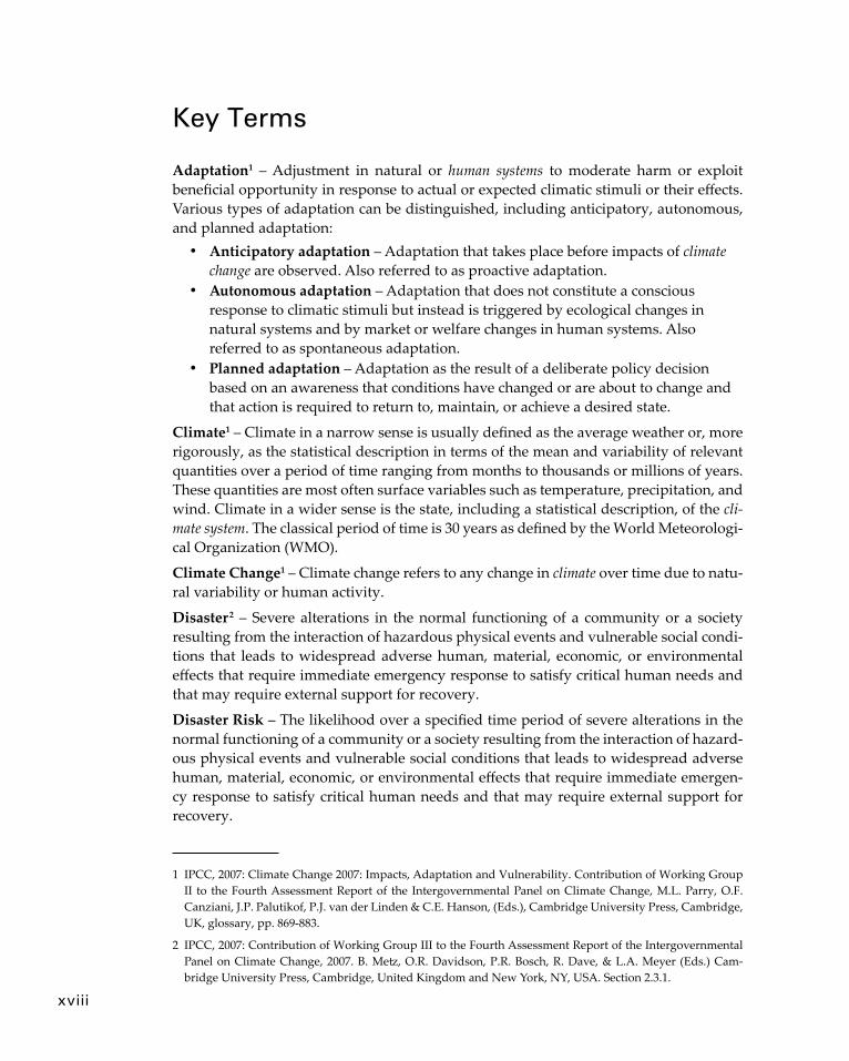
Key Terms
Adaptation1 – Adjustment in natural or human systems to moderate harm or exploit beneficial opportunity in response to actual or expected climatic stimuli or their effects. Various types of adaptation can be distinguished, including anticipatory, autonomous, and planned adaptation:
• Anticipatory adaptation – Adaptation that takes place before impacts of climate change are observed. Also referred to as proactive adaptation.
• Autonomous adaptation – Adaptation that does not constitute a conscious response to climatic stimuli but instead is triggered by ecological changes in natural systems and by market or welfare changes in human systems. Also referred to as spontaneous adaptation.
• Planned adaptation – Adaptation as the result of a deliberate policy decision based on an awareness that conditions have changed or are about to change and that action is required to return to, maintain, or achieve a desired state.
Climate1 – Climate in a narrow sense is usually defined as the average weather or, more rigorously, as the statistical description in terms of the mean and variability of relevant quantities over a period of time ranging from months to thousands or millions of years. These quantities are most often surface variables such as temperature, precipitation, and wind. Climate in a wider sense is the state, including a statistical description, of the cli-mate system. The classical period of time is 30 years as defined by the World Meteorologi-cal Organization (WMO).
Climate Change1 – Climate change refers to any change in climate over time due to natu-ral variability or human activity.
Disaster 2 – Severe alterations in the normal functioning of a community or a society resulting from the interaction of hazardous physical events and vulnerable social condi-tions that leads to widespread adverse human, material, economic, or environmental effects that require immediate emergency response to satisfy critical human needs and that may require external support for recovery.
Disaster Risk – The likelihood over a specified time period of severe alterations in the normal functioning of a community or a society resulting from the interaction of hazard-ous physical events and vulnerable social conditions that leads to widespread adverse human, material, economic, or environmental effects that require immediate emergen-cy response to satisfy critical human needs and that may require external support for recovery.
1 IPCC, 2007: Climate Change 2007: Impacts, Adaptation and Vulnerability. Contribution of Working Group II to the Fourth Assessment Report of the Intergovernmental Panel on Climate Change, M.L. Parry, O.F. Canziani, J.P. Palutikof, P.J. van der Linden & C.E. Hanson, (Eds.), Cambridge University Press, Cambridge, UK, glossary, pp. 869-883.
2 IPCC, 2007: Contribution of Working Group III to the Fourth Assessment Report of the Intergovernmental Panel on Climate Change, 2007. B. Metz, O.R. Davidson, P.R. Bosch, R. Dave, & L.A. Meyer (Eds.) Cam-bridge University Press, Cambridge, United Kingdom and New York, NY, USA. Section 2.3.1.
xviii

Exposure3 – The nature and degree to which a system is exposed to significant climatic variations.
Mainstreaming – The incorporation of climate change considerations into established or ongoing development programs, policies, or management strategies rather than devel-oping adaptation and mitigation initiatives separately.
Mitigation1 – An anthropogenic intervention to reduce the anthropogenic forcing of the climate system, including strategies to reduce greenhouse gas sources and emissions and enhance greenhouse gas sinks.
Resilience2 – The ability of a system and its component parts to anticipate, absorb, ac-commodate, or recover from the effects of a hazardous event in a timely and efficient manner through ensuring the preservation, restoration, or improvement of its essential basic structures and functions.
Risk3 – Combination of the probability of an event and its consequences.
Sensitivity1 – Sensitivity is the degree to which a system is affected either adversely or beneficially by climate variability or change. The effect may be direct, such as a change in crop yield in response to a change in the mean, range, or variability of temperature, or indirect, such as damages caused by an increase in the frequency of coastal flooding due to sea-level rise.
Thermal Expansion4 – In connection with sea level, this refers to the increase in vol-ume (and decrease in density) that results from warming water. A warming of the ocean leads to an expansion of the ocean volume and hence an increase in sea level.
Threshold1 – The level of magnitude of a system process at which sudden or rapid change occurs. A point or level at which new properties emerge in an ecological, eco-nomic or other system, invalidating predictions based on mathematical relationships that apply at lower levels.
Transformation2 – The altering of fundamental attributes of a system (including value systems; regulatory, legislative, or bureaucratic regimes; financial institutions; and tech-nological or biological systems).
Vulnerability1 – the degree to which a system is susceptible to, and unable to cope with, adverse effects of climate change, including climate variability and extremes. Vulner-ability is a function of the character, magnitude, and rate of climate change and variation to which a system is exposed, its sensitivity, and its adaptive capacity.
3 IPCC, 2001: Climate Change 2001: Impacts, Adaptation, and Vulnerability. J. J. McCarthy, O. F. Canziani, N. A. Leary, D. J. Dokken and K. S. White (eds) Cambridge University Press, Cambridge, United Kingdom and New York, NY, USA, glossary, pp. 982-996.
4 IPCC, 2001: Climate Change 2001: The Scientific Basis. Contribution of Working Group I to the Third As-sessment Report of the Intergovernmental Panel on Climate Change [Houghton, J.T.,Y. Ding, D.J. Griggs, M. Noguer, P.J. van der Linden, X. Dai, K.Maskell, and C.A. Johnson (eds.)]. Cambridge University Press, Cambridge, United Kingdom and New York, NY, USA, glossary, pp. 787-797.
Key Terms xix
xx
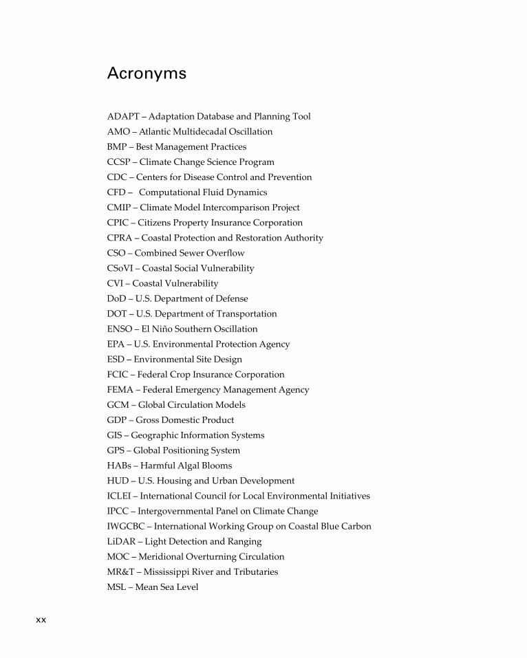
Acronyms
ADAPT – Adaptation Database and Planning ToolAMO – Atlantic Multidecadal OscillationBMP – Best Management PracticesCCSP – Climate Change Science ProgramCDC – Centers for Disease Control and PreventionCFD – Computational Fluid DynamicsCMIP – Climate Model Intercomparison ProjectCPIC – Citizens Property Insurance Corporation CPRA – Coastal Protection and Restoration AuthorityCSO – Combined Sewer OverflowCSoVI – Coastal Social VulnerabilityCVI – Coastal VulnerabilityDoD – U.S. Department of Defense DOT – U.S. Department of TransportationENSO – El Niño Southern OscillationEPA – U.S. Environmental Protection AgencyESD – Environmental Site DesignFCIC – Federal Crop Insurance CorporationFEMA – Federal Emergency Management AgencyGCM – Global Circulation ModelsGDP – Gross Domestic Product GIS – Geographic Information SystemsGPS – Global Positioning SystemHABs – Harmful Algal BloomsHUD – U.S. Housing and Urban DevelopmentICLEI – International Council for Local Environmental InitiativesIPCC – Intergovernmental Panel on Climate Change IWGCBC – International Working Group on Coastal Blue Carbon LiDAR – Light Detection and RangingMOC – Meridional Overturning CirculationMR&T – Mississippi River and TributariesMSL – Mean Sea Level

Acronyms xxi
NAO – North Atlantic OscillationNCA – National Climate AssessmentNFIP – National Flood Insurance ProgramNIC – National Intelligence CouncilNOAA – National Oceanic and Atmospheric AdministrationNREL – National Renewable Energy LaboratoryOCS – Outer Continental Shelf OREC – Ocean Renewable Energy Coalition P&C – Property and Casualty InsurersPCC – Pacific Coast CollaborativePDO – Pacific Decadal OscillationPVI – Place Vulnerability IndexPWD – Philadelphia Water DepartmentSAV – Submerged Aquatic VegetationSLCS – Sea Level Change ScenariosSRES – Special Report on Emissions ScenariosTHC – Thermohaline CirculationUSACE – U.S. Army Corps of EngineersUSGCRP – U.S. Global Change Research Program VBZD – Vector-Borne and Zoonotic DiseaseVOS – Voluntary Observing ShipWAIS – West Antarctic Ice SheetWPCPs – Wastewater Pollution Control Plants
xxii
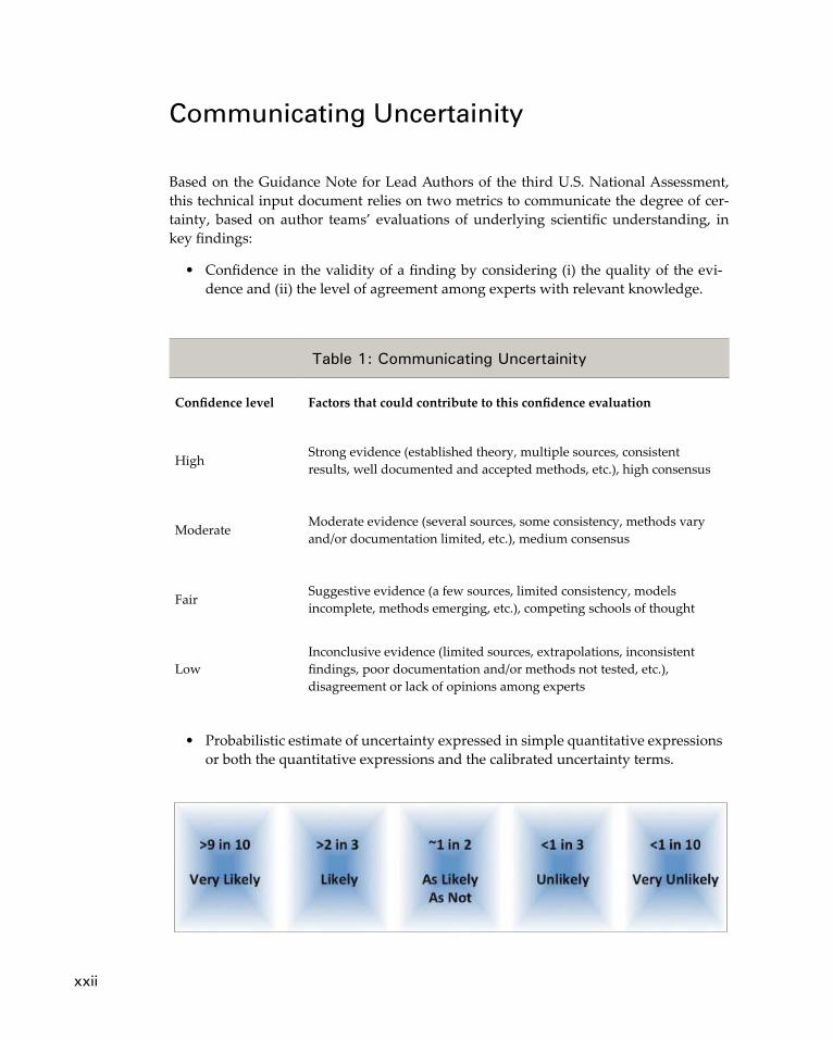
Communicating uncertainity
Based on the Guidance Note for Lead Authors of the third U.S. National Assessment, this technical input document relies on two metrics to communicate the degree of cer-tainty, based on author teams’ evaluations of underlying scientific understanding, in key findings:
• Confidence in the validity of a finding by considering (i) the quality of the evi-dence and (ii) the level of agreement among experts with relevant knowledge.
• Probabilistic estimate of uncertainty expressed in simple quantitative expressions or both the quantitative expressions and the calibrated uncertainty terms.
Table 1: Communicating Uncertainity
Confidence level Factors that could contribute to this confidence evaluation
High Strong evidence (established theory, multiple sources, consistent results, well documented and accepted methods, etc.), high consensus
Moderate Moderate evidence (several sources, some consistency, methods vary and/or documentation limited, etc.), medium consensus
Fair Suggestive evidence (a few sources, limited consistency, models incomplete, methods emerging, etc.), competing schools of thought
LowInconclusive evidence (limited sources, extrapolations, inconsistent findings, poor documentation and/or methods not tested, etc.), disagreement or lack of opinions among experts

executive Summary
The coast has long provided communities with a multitude of benefits including an abundance of natural resources that sustain economies, societies, and ecosystems. Coasts provide natural harbors for commerce, trade, and transportation; beaches and shorelines that attract residents and tourists; and wetlands and estuaries that are criti-cal for fisheries and water resources. Coastal ecosystems provide critical functions to cycle and move nutrients, store carbon, detoxify wastes, and purify air and water. These areas also mitigate floods and buffer against coastal storms that bring high winds and salt water inland and erode the shore. Coastal regions are critical in the development, transportation, and processing of oil and natural gas resources and, more recently, are being explored as a source of energy captured from wind and waves. The many benefits and opportunities provided in coastal areas have strengthened our economic reliance on coastal resources. Consequently, the high demands placed on the coastal environment will increase commensurately with human activity. Because 35 U.S. states, common-wealths, and territories have coastlines that border the oceans or Great Lakes, impacts to coastline systems will reverberate through social, economic, and natural systems across the U.S.
Impacts on coastal systems are among the most costly and most certain consequences of a warming climate (Nicholls et al., 2007). The warming atmosphere is expected to accelerate sea-level rise as a result of the decline of glaciers and ice sheets and the ther-mal expansion of sea water. As mean sea level rises, coastal shorelines will retreat and low-lying areas will tend to be inundated more frequently, if not permanently, by the advancing sea. As atmospheric temperature increases and rainfall patterns change, soil moisture and runoff to the coast are likely to be altered. An increase in the intensity of climatic extremes such as storms and heat spells, coupled with other impacts of climate change and the effects of human development, could affect the sustainability of many existing coastal communities and natural resources.
This report, one of a series of technical inputs for the third NCA conducted under the auspices of the U.S. Global Change Research Program, examines the known effects and relationships of climate change variables on the coasts of the U.S. It describes the impacts on natural and human systems, including several major sectors of the U.S. economy, and the progress and challenges to planning and implementing adaptation options. Below we present the key findings from each chapter of the report, beginning with the follow-ing key findings from Chapter 1: Introduction and Context.
Key Findings
f Changes in the environment associated with human development activities compromise the ability of the coasts to continue to provide a multitude of bene-fits including food, clean water, jobs, recreation, and protection from storms. In some cases, these benefits are further impacted by the changing climate. High Confidence.
xxiii
xxiv CoAsTAl ImpACTs, AdApTATIon, And VUlnerAbIlITIes
f Adapting to the changing climate will be a challenge for coastal economies that contributed $8.3 trillion to the GDP in 2010 and depend on coastal landforms, water resources, estuaries, and other natural resources to sustain them. High Confidence.
f Coastal states and communities will need strategies to enable them to manage current stressors and the confounding impacts of a changing climate to conserve, protect, and restore coastal habitats. Easing the existing pressures on coastal environments to improve their resiliency is one method of coping with the adverse effects of climate change. High Confidence.
Physical Climate Forces
A changing global climate combined with intense human activity imposes additional stresses on coastal environments. Although the climate is warming at a global scale, the impacts and the timing of the impacts are highly variable across coastal regions. Some effects, such as rising sea level, are already evident in increased erosion of beaches, more frequent flooding from both rivers and tidal surge, and wetlands converting to open wa-ter. Sea surface temperatures have risen over much of the globe, and hurricane activity has increased over the past several decades, particularly in the Atlantic basin, although it is uncertain whether these storm changes exceed the levels expected from natural causes. In addition, increased uptake of atmospheric carbon dioxide by the oceans has increased ocean acidity that threatens coral reefs and shellfish. The primary driving forc-es are: sea-level rise, changes in temperature, precipitation, major storm events includ-ing waves, winds and currents, and changing ocean circulation patterns. These driving forces interact in complex ways with the landforms and infrastructure that make the coasts particularly vulnerable to many of the impacts of climate change.
Key Findings
f The coasts of the U.S. are home to many large urban centers and important infra-structure such seaports, airports, transportation routes, oil import and refining facilities, power plants, and military bases. All are vulnerable to varying degrees to impacts of global warming such as sea-level rise, storms, and flooding. High Confidence.
f Physical observations collected over the past several decades from the land, coasts, oceans, and the atmosphere, as well as environmental indicators, show that warming and some related environmental changes are occurring globally at rates greater than can be expected due to natural processes. These climate-related changes are highly varied, but some are likely due in large part to anthropogeni-cally increased atmospheric concentrations of greenhouse gases and altered land surface properties. High Confidence.
f Findings from many independent scientific studies conclude that these changes are consistent with global warming. The primary changes observed are rising sea level and average global air, land, and ocean temperatures; heightening temperature and precipitation extremes in some regions; and increasing levels
executive summary xxv
of oceans acidification and rates of glacier and ice sheet melt. High Confidence. f Most coastal landforms, such as barrier islands, deltas, bays, estuaries, wetlands,
coral reefs, are highly dynamic and sensitive to even small changes in physical forces and feedbacks such as warming, storms, ocean circulation, waves and currents, flooding, sediment budgets, and sea-level rise. High Confidence.
f The effects of sea-level rise on coasts vary considerably from region-to-region and over a range of spatial and temporal scales. Land subsidence in certain loca-tions causes relative sea-level rise to exceed global mean sea-level rise. Land uplift such as that found in Alaska and the Northwestern Pacific coast can reduce effects of global mean rise. The effects will be greatest and most immediate on low-relief, low-elevation parts of the U.S. coast along the Gulf of Mexico, mid-Atlantic states, northern Alaska, Hawaii, and island territories and especially on coasts containing deltas, coastal plains, tidal wetlands, bays, estuaries, and coral reefs. Beaches and wetlands on steep cliff coasts and shores backed with seawalls may be unable to move landward or maintain their landform with sea-level rise. Many areas of the coast are especially vulnerable because of the often detrimental effects of development on natural processes. High Confidence.
f The gradual inundation from recent sea-level rise is evident in many regions such as the mid-Atlantic and Louisiana where high tides regularly flood roads and areas that were previously dry, and in stands of “ghost forests,” in which trees are killed by intrusion of brackish water. High Confidence
f Sea level change and storms are dominant driving forces of coastal change as observed in the geologic record of coastal landforms. Increasingly, sea-level rise will become a hazard for coastal regions because of continued global mean sea-level rise, including possibly accelerated rates of rise that increase risk to coastal regions. As the global climate continues to warm and ice sheets melt, coasts will become more dynamic and coastal cities and low-lying areas will be increasingly exposed to erosion, inundation, and flooding. High Confidence.
f No coordinated, interagency process exists in the U.S. for identifying agreed upon global mean sea-level rise projections for the purpose of coastal planning, policy, or management, even though this is a critical first step in assessing coastal impacts and vulnerabilities. High Confidence.
f Global sea level rose at a rate of 1.7 millimeters/year during the 20th century. The rate has increased to over 3 millimeters/year in the past 20 years and scien-tific studies suggest high confidence (>9 in 10 chance) that global mean sea level will rise 0.2 to 2 meters by the end of this century. Some regions such as Loui-siana and the Chesapeake Bay will experience greater relative rise due to factors such as land subsidence, gravitational redistribution of ice-sheet meltwater, ocean circulation changes, and regional ocean thermostatic effects. Other regions undergoing land uplift, such as Alaska, will experience lesser sea-level rise. High Confidence.
f Variability in the location and time-of-year of storm genesis can influence land-falling storm characteristics, and even small changes can lead to large changes in landfalling location and impact. Although scientists have only low confidence in
xxvi CoAsTAl ImpACTs, AdApTATIon, And VUlnerAbIlITIes
the sign of projected changes to the coast of storm-related hazards that depend on a combination of factors such as frequency, track, intensity, and storm size, any sea-level rise is virtually certain to exacerbate storm-related hazards. High Confidence.
f Although sea-level rise and climate change have occurred in the past, the increasing human presence in the coastal zone will make the impacts different for the future. Land use and other human activities often inhibit the natural response of physical processes and adaptation by plants and animals. In some areas, erosion and wetland loss are common because sediment budgets have been reduced, while, in other regions, excess sediment is in-filling harbors, chan-nels, and bays. High Confidence.
f Observations continue to indicate an ongoing, warming-induced intensification of the hydrologic cycle that will likely result in heavier precipitation events and, combined with sea-level rise and storm surge, an increased flooding severity in some coastal areas, particularly the northeast U.S. Moderate Confidence.
f Temperature is primarily driving environmental change in the Alaskan coastal zone. Sea ice and permafrost make northern regions particularly susceptible to temperature change. For example, an increase of two degrees Celsius could basi-cally transform much of Alaska from frozen to unfrozen, with extensive implica-tions. Portions of the north and west coast of Alaska are seeing dramatic increases in the rate of coastal erosion and flooding due to sea ice loss and permafrost melting. As a consequence, several coastal communities are planning to relocate to safer locations. Relocation is a difficult decision that is likely to become more common in the future for many coastal regions. High Confidence.
f Methane is a primary greenhouse gas. Large reserves of methane are bound-up in Alaska’s frozen permafrost. These are susceptible to disturbance and methane release if the Arctic continues to warm. The additional methane released may result in even greater greenhouse warming of the atmosphere. High Confidence.
Vulnerability and Impacts on natural resources
Climate and non-climate stressors originating from terrestrial and marine sources in-teract at the coast to influence coastal habitats (Nicholls et al., 2007; Rosenzweig et al., 2007). Increased temperatures and altered precipitation patterns interact with changing land use and land cover practices to affect soil moisture, ground water levels, hydrology, sediment supply, and salinity in watersheds. Sea-level rise, changing ocean currents, increased wave heights, and intensification of coastal storms interact with the shoreline to exacerbate coastal erosion, flooding, and saltwater intrusion. As the physical environ-ment changes, the range of a particular ecosystem will expand, contract, or migrate in response. Changes in range as well as structure and function are evident in many types of ecosystems.
The interactions of the many stressors result in complex changes to natural coastal systems that may not be predicted by the response from any single stressor. Positive and negative impacts occur when the impact of one stressor is either strengthened or
executive summary xxvii
weakened by variation in another, and the combined influence of multiple stressors can result in unexpected ecological changes if populations or ecosystems are pushed beyond a critical threshold or tipping point (Harley et al., 2006; Lubchenco & Petes, 2010). Both theoretical and empirical examples of thresholds are rising and increasing knowledge about how climate and non-climate stressors interact to propel sudden shifts in eco-systems. These examples also show that many of the responses of natural systems are linked to those of human systems.
Key Findings
f Multiple stressors interact at the coast, which directly impacts natural resources. The responses of natural coastal systems to climate change are complex and subject to nonlinear changes and tipping points. Many of these responses are heavily influenced by the way they are linked with human systems. High Confidence.
f Wetland ecosystems are vulnerable to relative rise in water levels and projected increases in storm activity in zones of significant human use. High Confidence.
f Mangrove range will expand as minimum temperatures increase. High Confidence.
f Coastal forests will tend to migrate upslope and poleward where they are able to keep pace with changing habitat conditions. High Confidence.
f The structure and functioning of estuary and coastal lagoon systems will change with alterations in habitat suitability and the timing of long-standing processes. High Confidence.
f Dynamic barrier island landscapes naturally migrate in response to storm activity and sea-level rise. This process will be confounded by human altera-tions. High Confidence.
f Because of altered sediment supplies and local subsidence, deltas, and the biodiversity they support, are at risk to drowning during rising sea levels. High Confidence.
f Mudflats are susceptible to threshold changes caused by the combined effects of sea-level rise, temperature, land use, altered flows, and increased nutrient runoff. High Confidence.
f Complex interactions between physical and biological factors, which make responses to climate change difficult to predict, have been demonstrated in rocky shore communities. High Confidence.
f Sea ice ecosystems are already being adversely affected by the loss of summer sea ice. Further changes are expected. High Confidence.
Vulnerability and Impacts on human development
Societal vulnerability of U.S. coasts is comprised of the vulnerabilities of economic sec-tors and associated livelihoods, water resources, energy, transportation, national defense,
xxviii CoAsTAl ImpACTs, AdApTATIon, And VUlnerAbIlITIes
investments in homes and other buildings, and the health and well-being of a diverse concentration of people from natives to recent immigrants and from the very poor to the tremendously wealthy. The interactions of climate-related vulnerabilities with other stressors such as economic downturn, environmental degradation, or pressures for de-velopment pose further analytical challenges. Because coastal watershed counties house a majority of U.S. cities, a significant percentage of the nation’s population may be more vulnerable to impacts under climate change and face loss of jobs, supply chain interrup-tions, and threats to public health, safety, and well-being as a result.
Key Findings
f Expanding economic and population exposure along the coast significantly increases the risk of harm and exposes already vulnerable communities to the impacts of climate change. Since 1980, roughly half of the nation’s new residential building permits were issued in coastal counties, which substantially increases vulnerability and risk of loss and adds to already populated and densely devel-oped metropolitan areas. High Confidence.
f The full measure of human vulnerability and risk is comprised of the vulner-abilities of human development, economic sectors, associated livelihoods, and human well-being. The interactions of climate-related vulnerabilities with other stressors in the coastal zone pose analytical challenges when coupled with the lack of quantitative, multi-stressor vulnerability assessments. High Confidence.
f Storm surge flooding and sea-level rise pose significant threats to public and private infrastructure that provides energy, sewage treatment, clean water, and transportation of people and goods. These factors increase threats to public health, safety, and employment in the coastal zone. High Confidence.
f Systematic incorporation of climate risk into the insurance industry’s rate-setting practices and other business investment decisions could present a cost-effective way to deal with low probability, high severity weather events. Without reform, the financial risks associated with both private and public hazard insurance are expected to increase as a result of expected climate change and sea-level rise. High Confidence.
f Expected public health impacts include a decline in seafood quality, shifts in disease patterns and increases in rates of heat-related morbidity. Better predic-tions of coastal related public health risks will require sustained multi-disci-plinary collaboration among researchers and health practitioners in the climate, oceanography, veterinary, and public health sciences. Moderate Confidence.
f Although the Department of Defense (DoD) has started to consider the impacts of climate change on coastal installations, operations, and military readiness, the DoD requires actionable climate information and projections at mission-relevant temporal and spatial scales to maintain effective training, deployment, and force sustainment capabilities. High Confidence.
executive summary xxix
Adaptation and Mitigation
Adaptation is emerging as an essential strategy for managing climate risk, and a broad range of adaptation initiatives are being pursued across a range of geopolitical scales. This interest in adaptation has emerged from: increased awareness that climate impacts are already occurring and unavoidable; growing availability of knowledge, data, and tools for the assessment of climate risk; and the interest of government agencies, busi-nesses, and communities in increasing their resilience to current climate variability and future climate change.
Adaptation planning activities are increasing, and tools and resources are now more available and accessible. Frequently, plans are being developed at varied spatial scales based upon the on-the-ground needs and adaptation drivers in the particular area; therefore, they are not easily integrated or comparable across geographic, sectoral, or political boundaries. Adaptation strategies are often developed separately from other existing planning efforts rather than being effectively and efficiently integrated into ex-isting coastal management and policy regimes. More efficiency can be achieved through integration into overall land use planning and ocean and coastal management policies and practices.
Although progress is being made in anticipatory adaptation planning, the implemen-tation of adaptation plans has proceeded more slowly due to a variety of barriers. Some implementation is occurring via changes in regulations and policy and decisions in transportation, infrastructure, land use, and development; however, challenges remain in translating adaptation planning efforts into increased resilience. Although many ad-aptation actions for coastal areas can be categorized as ‘no regrets’ actions that can be implemented under a range of climate scenarios and pose few opportunity costs, more substantive actions may have larger financial, policy, or legal hurdles. Overlapping and sometimes conflicting laws, often designed without consideration of a changing climate, can prevent the adoption of adaptive measures.
Key Findings
f Although adaptation planning activities in the coastal zone are increasing, they generally occur in an adhoc manner and at varied spatial scales dictated by on-the-ground needs and adaptation drivers in the particular area. Efficiency of adaptation can be improved through integration into overall land use planning and ocean and coastal management. High Confidence.
f In some cases, adaptation is being directly integrated, or mainstreamed, into existing decision-making frameworks regarding zoning and floodplain, coastal, and emergency management, but these frameworks are not always perfect fit and sometimes existing laws pose a barrier to implementation. Very High Confidence.
f Tools and resources to support adaptation planning are increasing but tech-nical and data gaps persist. As adaptation planning has evolved, recognition has grown regarding the need for detailed information that is compatible with organizational decision-making processes and management systems. Very High Confidence.

xxx CoAsTAl ImpACTs, AdApTATIon, And VUlnerAbIlITIes
f Although adaptation planning has an increasingly rich portfolio of case studies that contribute to shared learning, the implementation of adaptation plans has proceeded at a much slower pace. Very High Confidence.
f Elements commonly found in adaptation plans include vulnerability assess-ments, monitoring and indicators, capacity building, education and outreach, regulatory and programmatic changes, implementation strategies, and a sector-by-sector approach. Very High Confidence.
f Although state and federal governments play a major role in facilitating adapta-tion planning, most coastal adaptation will be implemented at the local level. Local governments are the primary actors charged with making the critical, basic land-use and public investment decisions and with working with commu-nity stakeholder groups to implement adaptive measures on the ground. Very High Confidence.
Climate change is altering all types of ecosystems and impacting human welfare and health, but effects are highly varied, pronounced along coasts, and likely to accelerate in decades ahead. A lack of understanding of the cumulative effects of climate and non-climate stressors as well as the interactions between human and natural systems cur-rently limits our ability to predict the extent of climate impacts. An integrated scientific program that seeks to learn from the historic and recent geologic past, and monitors ongoing physical, environmental, and societal changes will improve the level of knowl-edge and reduce the uncertainty about potential responses of coasts to sea-level rise and other drivers of coastal change. This, in turn, will improve the ability of communities to assess their vulnerability and to identify and implement adaptation options that address the impacts and associated uncertainties of the projections.

1
Chapter 1
Introduction and Context
Key Findings
f Changes in the environment associated with human development activities compromise the ability of the coasts to continue to provide a multitude of bene-fits including food, clean water, jobs, recreation, and protection from storms. In some cases, these benefits are further impacted by the changing climate. High Confidence.
f Adapting to the changing climate will be a challenge for coastal economies that contributed $8.3 trillion to the GDP in 2010 and depend on coastal landforms, water resources, estuaries, and other natural resources to sustain them. High Confidence.
f Coastal states and communities will need strategies to enable them to manage current stressors and the confounding impacts of a changing climate to conserve, protect, and restore coastal habitats. Easing the existing pressures on coastal environments to improve their resiliency is one method of coping with the adverse effects of climate change. High Confidence.
1.1 Scope and Purpose
Impacts on coastal systems are among the most costly and most certain consequences of a warming climate (Nicholls et al., 2007). The warming atmosphere is expected to accelerate sea-level rise as a result of the decline of glaciers and ice sheets and the ther-mal expansion of sea water. As mean sea level rises, coastal shorelines will retreat and low-lying areas will tend to be inundated more frequently, if not permanently, by the advancing sea. As atmospheric temperature increases and rainfall patterns change, soil moisture and runoff to the coast are likely to be altered. An increase in the intensity of climatic extremes such as storms and heat spells, coupled with other impacts of climate change and the effects of human development, could affect the sustainability of many existing coastal communities and natural resources. This report examines the known ef-fects and relationships of these and other climate change variables on coasts of the U.S. It also describes how several major sectors of the U.S. economy are likely to be affected as well as the diversity of adaptation options that are either being considered or already implemented in coastal regions.
This report is one of a series of technical inputs for the third NCA conducted un-der the auspices of the U.S. Global Change Research Program. The U.S. Global Change Research Act of 1990 requires that periodic national climate assessments be conducted
2 CoAsTAl ImpACTs, AdApTATIon, And VUlnerAbIlITIes
and submitted to the President and the Congress. Each assessment acts as a national snapshot or status report on climate change science and impacts. Two previous national assessment reports, each containing a brief chapter on coastal impacts, were published in 2000 and 2009.
The primary purpose of this report is to provide a technical foundation for the coastal chapter of the third NCA. The third U.S. assessment report is intended for use by com-munities and the nation as a whole to create sustainable and environmentally sound development paths. It will also provide a basis for prioritizing federal climate science investments and for identifying the most likely hotspots of societal vulnerability during the coming decades.
This assessment of coastal impacts, adaptation, and vulnerability in coastal regions of the United States begins with a characterization of the economic, cultural, and ecological significance of the coastal zone. This first chapter also summarizes how this report links with other topics covered in the third NCA. Chapter 2 provides an overview of the phys-ical drivers of change in coastal ecosystems. Chapters 3 and 4 describe the observed and projected impacts on natural coastal ecosystems and coastal communities, respectively. Chapter 5 addresses the societal adaptation and mitigation responses to climate change in the coastal zone. The last chapter of this report addresses the science needs of coastal decision makers as they begin to prepare for and adapt to climate change.
1.2 Linkages and overlapping Topics of the nCA
A total of 35 U.S. states, commonwealths, and territories have coastlines that border the oceans or Great Lakes. This assessment is intended to broadly characterize climate im-pacts, adaptation, and vulnerabilities for U.S. coastal regions. Due to the geography of the U.S. coastline and the importance of the coast to the U.S. economy, this synthesis relating to coastal systems intersects with many other sectoral and regional assessment activities that are being conducted to support the NCA. Examples of these intersecting assessment activities include:
• Regional Assessments. All eight regions of the NCA have coastal areas, whether on the Atlantic, Gulf of Mexico, Pacific Islands, or Great Lakes shores. Regional assessment reports will address impacts such as changing water levels, storm intensities, and precipitation more specifically, providing localized information using the available downscaled data, models, and regional scenarios developed for that area.
• Great Lakes. A separate report on the potential impacts of climate change on the Great Lakes region has been prepared, and some impacts on the U.S coasts of the lakes are discussed in this document.
• Water Resources. A variety of challenges to managing water supply and waste-water treatment will be encountered by water resource managers as they face changes in precipitation patterns and sea-level rise. Changes in the timing and supply of freshwater to coastal aquifers and through surface waters and salt-water intrusion into the system could impact water management infrastructure and water supplies for residential, commercial, and industrial uses, as well as
Introduction and Context 3
irrigation for agriculture. Rising sea levels and increased storm intensity could impact water control structures such as levees and dams in the coastal zone.
• Agriculture. The impacts of climate change on agriculture may be intensified in low-lying coastal areas. Saltwater intrusion may render some lands inappro-priate for farming. Stronger storms and increased precipitation or drought may lead to major changes in planting patterns and types of crops grown.
• Forestry. In coastal areas, forests may be affected by many of the same factors as agriculture, but increased severity of storms may have a greater impact on for-ests due to the longer cycle from planting to harvest. Loss of standing timber due to high winds may also have long term economic impacts. Saltwater encroach-ment and more frequent saturation of coastal forest soils may affect the potential for forest regeneration and other silvicultural practices.
• Public Health. Climate-related impacts on health and well-being include im-pacts on food supply, disease transmission, and environmental health. An in-crease is expected in contamination of coastal fishing and recreational waters in areas with high runoff and stressed sanitation systems; changes in access to and quality of food from the sea; and northward shifts in habitat. Vector-borne diseases may also be intensified in coastal areas as temperature and rainfall pat-terns change. Higher concentrations of populations in coastal areas may inten-sify the impacts of increased heat and humidity in coastal areas.
• Transportation. Increased flooding and inundation of roads and bridges in coastal areas may impede emergency preparation for and response to coastal storms, delay ground and other transportation, or alter traffic patterns. Improve-ments to maritime transportation infrastructure to respond to climate change may be a complex mix of public and private investment because most freight fa-cilities are privately owned. Maintaining effective transportation through ports is of special concern due to their significant impact on the national economy.
• Energy Supply. Most saltwater consumption in U.S. coastal counties occurs dur-ing thermoelectric power generation. Changes in water temperature may reduce the effectiveness of water as a cooling medium. The coasts are areas of explora-tion for energy sources including traditional sources, such as the extraction and transportation of offshore oil to inland areas, and alternative sources, such as tidal, wave, and wind energy.
• Ecosystems and Biodiversity. The ecosystems and biodiversity report of the NCA will examine the impacts of rising sea levels and other changing climatic factors on land cover and ecosystems. Temperature and changes in the hydro-logic cycle are likely to have significant effects on both coastal ecosystems and biodiversity. On the coast, wetlands and the associated species will face pressure from changes in salinity, inundation, and erosion. As coastal areas continue to develop, less upland area will be available for wetland restoration or migration due to the presence of hardened shorelines.
• Urban Infrastructure and Vulnerability. Most of the U.S. population lives with coastal watersheds and a significant portion of the nation’s infrastructure is at risk due to increased inundation and erosion from storms and sea-level rise.
4 CoAsTAl ImpACTs, AdApTATIon, And VUlnerAbIlITIes
• Marine. Identifying a firm boundary between coastal and marine issues associat-ed with climate change is difficult. Sediments, water, and nutrients move across the coastal and marine systems affecting water quality conditions and habitats in both realms. Many intersections exist between the marine chapter and the coastal chapter because of the intersections between geography and resources. For example, estuaries and coastal marshes provide critical nursery habitats for many marine species.
1.3 reliance on the Coastal Zone
The coast has long been an area that has provided communities with a multitude of ben-efits: food, clean water, jobs, recreation, and protection from hurricanes. Coasts provide natural harbors for commerce, trade, and transportation; beaches and shorelines that attract residents and tourists; and wetlands and estuaries that are critical for sustained fisheries. Healthy coastal ecosystems cycle and move nutrients, store carbon, detoxify wastes, and purify air and water. Coastal ecosystems help to mitigate floods and serve as buffers from coastal storms that bring high winds and salt water inland and erode the shore. Coastal regions have also been critical in the development, transportation, and processing of oil and natural gas resources and, more recently, have been explored as a source of energy captured from wind and waves. Over 56 percent of our nation’s total energy production occurred in coastal states in 2009 (NOAA, 2011a). The ability of coasts to provide this suite of ecosystem services is being compromised by environmen-tal alterations associated with human development activities and, in some cases, further impacted by the changing climate.
Increasing Population and Changing Land Use
Employment, recreation, and tourism, water-based commerce, and energy and mineral production are driving forces of population migration to coastal areas (Bookman et al., 1999; H. John Heinz Center, 2000; U.S. Commission on Ocean Policy, 2004). In 2010, 164 million people, a little more than 50 percent of the nation’s total population, resided within the coastal watershed counties5 of the U.S. and territories, including the Great Lakes (Figure 1-1). From 1970 to 2010, U.S. population in these coastal watershed coun-ties increased by 45 percent, or 50.9 million people (NOAA, 2011b). These population
5 NOAA maintains a list of “NOAA Coastal Watershed Counties,” derived from quantitative associations with NOAA coastal watersheds and USGS coastal cataloging units as delineated in the NOAA Coastal As-sessment Framework, or CAF (http://coastalgeospatial.noaa.gov/). A county is considered a coastal water-shed county, having a substantial watershed-based impact on coastal and ocean resources, if one of the following criteria is met: (1) at a minimum, 15 percent of the county’s total land area is located in a coastal watershed; or (2) a portion of or an entire county accounts for at least 15 percent of a coastal USGS 8-digit cataloging unit. Exceptions to this 15-percent rule include Cook and Lake Counties in Illinois, Allan Parish, LA; Highlands, FL; and Greene, NC; these are included as NOAA coastal watershed counties. The NOAA Coastal Assessment Framework does not include Alaska or Hawaii; however, all counties, called boroughs and census areas in Alaska, that contain the intersection of the shoreline of the 2010 Census County Bound-ary and a USGS cataloging unit are included as NOAA Coastal Watershed Counties. This exception affects all 5 counties in Hawaii and 25 counties in Alaska.
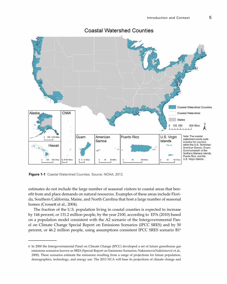
Introduction and Context 5
estimates do not include the large number of seasonal visitors to coastal areas that ben-efit from and place demands on natural resources. Examples of these areas include Flori-da, Southern California, Maine, and North Carolina that host a large number of seasonal homes (Crossett et al., 2004).
The fraction of the U.S. population living in coastal counties is expected to increase by 144 percent, or 131.2 million people, by the year 2100, according to EPA (2010) based on a population model consistent with the A2 scenario of the Intergovernmental Pan-el on Climate Change Special Report on Emissions Scenarios (IPCC SRES) and by 50 percent, or 46.2 million people, using assumptions consistent IPCC SRES scenario B16
6 In 2000 the Intergovernmental Panel on Climate Change (IPCC) developed a set of future greenhouse gas emissions scenarios known as SRES (Special Report on Emissions Scenarios; NakicenovicNakićenović et al., 2000). These scenarios estimate the emissions resulting from a range of projections for future population, demographics, technology, and energy use. The 2013 NCA will base its projections of climate change and
Figure 1-1 Coastal Watershed Counties. Source: NOAA, 2012.
6 CoAsTAl ImpACTs, AdApTATIon, And VUlnerAbIlITIes
(Nakićenović et al., 2000; U.S. EPA, 2010). Because the nation’s coastal watershed coun-ties, excluding Alaska, represent only 17 percent of total U.S. land area (NOAA, 2011b), population densities are expected to be higher in these areas than in other parts of the country.
Concomitant with increasing populations, land use patterns have changed along the coast. Many agricultural and previously undeveloped areas have been converted into low-density residential, commercial, and industrial uses (Beach, 2002). Consequent sprawl and urbanization has affected coastal ecosystems in a variety of ways. Altera-tions to land use and natural inlets impact nutrient runoff, stormwater management, and water quality; shoreline hardening and dredging alters coastal circulation patterns exacerbating shoreline erosion and the ability to attenuate flooding; and development that alters land cover impairs habitats for native species. Coastal storms interact with changing land uses and land cover, particularly in terms of coastal flooding that puts people and property at risk.
The EPA developed a methodology for quantifying relationships between popula-tion, housing density, percent of impervious surfaces, and water quality impairment (EPA, 2009). If present relationships are maintained in the future, the increase in popula-tion through the end of this century, under the A2 emissions scenario, will contribute to 37 and, under the B1 emissions scenario, 11 additional coastal watersheds with a land surface of 10 percent or more total impervious surface cover, a threshold at which water quality and aquatic communities are likely to be impaired, though substantially lower thresholds have been shown (Angradi et al., 2010; Cuffney et al., 2010; King et al., 2011). Although the extent and permeability of impervious surfaces can be mitigated through a variety of strategies (Dietz, 2007) increased residential housing and commercial and industrial development are expected to continue to result in land and resource uses that degrade ecosystem services (Schlacher et al., 2011).
Changing Coastal Economy
The nation’s economy is highly dependent on the coasts. Fifty-eight percent of our na-tion’s Gross Domestic Product (GDP), valued at $8.3 trillion, is generated in the coastal watershed counties along the oceans and Great Lakes (NOAA, 2011c). If the nation’s coastal watershed counties were considered an individual country, they would rank number two in GDP globally, only behind the U.S. as a whole (NOAA, 2011c). Eco-nomic activity in U.S. coastal watershed counties accounts for approximately 66 mil-lion jobs and $3.4 trillion in wages (NOAA, 2011c) through a diversity of industries and
impacts primarily on the “A2” and “B1” SRES scenarios. The A2 family of scenarios assumes a world of na-tions that operate independently, with slow technological development and continuously increasing popu-lation. Under the A2 higher emissions scenario, the concentration of atmospheric carbon dioxide reaches about 850 ppm by 2100. The B1 lower-emissions scenario represents a world with high economic growth and a global population that peaks mid-century and then declines. This scenario includes a shift to less fossil fuel-intensive industries and the introduction of clean and resource-efficient technologies. In the B1 scenario the emissions of greenhouse gases peak around mid-century and then decline, though atmospheric carbon dioxide concentrations reach 550 ppm by 2100, which is approximately double pre-industrial levels (Nakićenović et al., 2000).
Introduction and Context 7
commerce. Over $1.9 trillion in imports came through U.S. ports in 2010, and these com-mercial ports directly supported over 13 million jobs (NOAA, 2011f).
Traditionally the U.S. coastal economy was dominated by manufacturing, but service industries are now the primary contributors (Kildow et al., 2009). Urban areas, where more than 9 in 10 residents and jobs are located, are the economic centers of the coast (Kildow et al., 2009). In 2007, coastal counties were more specialized than the U.S. as a whole in four major economic sectors: professional and business services, informa-tion services, financial activities including real estate, and other services7 (Kildow et al., 2009). In addition, shore-adjacent counties show greater specialization in the leisure and hospitality service sector, reflecting the importance of coasts for tourism and recreation. Every coastal state hosts more than one million coastal visitors each year (Pendleton, 2008).
Our nation’s ocean and Great Lakes coasts are important centers for commercial and recreational fishing. The U.S. seafood industry includes the commercial harvest sector, seafood processors and dealers, seafood wholesalers and distributors, importers, and seafood retailers. In 2009, this industry supported approximately 1 million full- and part-time jobs and generated $116 billion in sales impacts, $32 billion in income impacts, and $48 billion in value added impacts (NOAA, 2011d). Recreational fishing also plays a large part in the economy, which contributed $50 billion in sales impacts to the U.S. economy, generated $23 billion in value added impacts, and supported over 327,000 jobs in 2009 (NOAA, 2011e).
The anticipated growth in coastal population alone is likely to increase the demand on resources that are critical to coastal economies. The next thirty years could bring the largest shift in the ocean and coastal economies since the arrival of industrialization and rapid urbanization in the late 19th century (Kildow et al., 2009).
Reliance on Coastal Ecosystems
All of the economically important sectors described in the preceding section are de-pendent upon healthy, functioning coastal ecosystems to provide an environment that sustains natural habitats and resources for use by communities. Population and infra-structure growth in coastal watersheds has placed stress on habitats that will increase with a changing climate. Between 1996 and 2006, freshwater and saltwater wetlands in the nation’s coastal watershed counties experienced a net decrease of 431.5 square miles (NOAA, 2011g). Collectively, marine and estuarine intertidal wetlands declined by an estimated 84,100 acres (34,050 ha) between 2004 and 2009 (Fish and Wildlife Service, 2009). The majority, 83 percent, of these intertidal wetland losses involved wetland con-version to open water. Some of this loss may be due to development practices; other
7 The Other Services sector includes establishments engaged in providing services not specifically provided for elsewhere in the North American Industry Classification System. Examples of establishments in this sec-tor are equipment and machinery repairing, promoting or administering religious activities, advocacy, and providing dry cleaning and laundry services, personal care services, death care services, pet care services, photofinishing services, and temporary parking services (OMB, 2007). Greater specialization in the leisure and hospitality service sector reflects the importance of coasts for tourism and recreation. Each coastal state hosts more than one million coastal visitors each year (Pendleton, 2008).
8 CoAsTAl ImpACTs, AdApTATIon, And VUlnerAbIlITIes
loss to subsidence and consequent water level rise. Some regions experienced gains in the categories of marine intertidal wetlands including beaches and shores and estuarine non-vegetated wetlands, which includes near-shore shoals and sand bars.
The EPA assessment (2011) of coastal water, sediment, fish, and habitat health indi-cates that the overall condition of our nation’s coastal waters is “fair.” Excess nutrients and contaminants enter the coastal system from agricultural systems and residential de-velopment through runoff, with rates that can be similar to paved surfaces, particularly in urban and suburban areas developed after 2000 (Woltemade, 2010; Yang & Zhang, 2011). An additional source of nutrients and contaminants is atmospheric deposition, which can occur from land use changes or changes in the jet stream and other atmo-spheric patterns that alter deposition amounts (Howarth, 2008; Mackey et al., 2010). Although fertilizer is the largest source of nitrogen in watersheds in the western U.S., at-mospheric deposition is next, accounting for approximately 30 percent of inputs (Schae-fer et al., 2009). Both terrestrial and atmospheric sources of nutrients lead to increased primary productivity and, with decay, increased oxygen demand (e.g., Rabalais et al., 2009). Although it offers some benefits, increased primary productivity can also lead to increased incidence of hypoxic conditions.
The impacts of nutrients and contaminants will also be influenced by changes in temperature, precipitation, convection, and sea level. For example, warmer water tem-peratures can increase algal productivity, which increases oxygen demand when algal blooms decay, and, consequently, the incidence of hypoxia. Hypoxic zones lead to de-clines of many species, including commercially important fish and shellfish. Some of these water quality impacts may be counteracted through increases in the frequency or intensity of precipitation that may deliver greater quantities of freshwater to the coastal zone (Rabalais et al., 2009); however, increased runoff will also interact with impervious surfaces of the built environment and thereby enhance the delivery of sediments, nu-trients, and contaminants to coastal ecosystems (NRC, 2008). Contaminants, including metals, herbicides, pesticides, and pathogens, that are introduced to the coast through runoff, atmospheric deposition, or other sources further impact coastal water quality. The presence of these contaminants affects the ecosystem by altering productivity and potentially species’ compositions and biodiversity as well as public health if humans are exposed to the contaminants. Environmental management practices in urban and agri-cultural settings can help to reduce the flux of sediments, nutrients, and contaminants to the coast, but the degree to which management actions can offset these impacts is uncertain.
Maintaining a Balance
Coastal resource managers are often charged with balancing the requirements for hu-man population growth and economic development with the protection of natural habitats and the ecosystem services they provide and upon which coastal economies depend. Many examples of large-scale efforts are underway in the U.S. to conserve the ecosystem services that the coast provides while allowing for its sustainable use. Within the USDOI, the U.S. National Park Service’s coastal park units cover more than 7,300 miles of shoreline (National Park Service, 2011), the National Wildlife Refuge System manages 556 refuges, and the U.S. Fish and Wildlife Service Coastal Program restores
Introduction and Context 9
coastal wetlands and upland habitat and permanently protected over 2 million acres of coastal habitat (Fish and Wildlife Service, 2012). NOAA also directly manages coastal areas through the Office of National Marine Sanctuaries, oversees critical fisheries habi-tats through the National Marine Fisheries Services, and supports regional to local con-servation and management efforts through the National Estuarine Research Reserves, state Coastal Zone Management programs, the Coral Reef Conservation Program, and the National Sea Grant College Program. The EPA also supports local efforts through the National Estuary program while the USDA/NRCS supports conservation principally through the Crop Protection Reserve Program. Many other public and private coastal acquisition and conservation efforts have been initiated in recent years; organizations like Trust for Public Lands, The Nature Conservancy, and the community land trusts are but a few of these key partners.
New concepts for future coastal development have also been introduced. Green in-frastructure planning is an example of a strategy to incorporate conservation of habitats into coastal communities. This concept for planning future urban growth promotes an interconnected network of protected land and water that supports native species, main-tains natural ecological processes, sustains air and water resources, and contributes to a community’s health and quality of life (Benedict & McMahon, 2006). Many other ex-amples of development planning that can help offset the potential impacts of climate change while concomitantly reducing the effects of human development on coasts are presented in Chapters 4 and 5 of this report.
A major challenge for coastal habitats and communities in the coming years will be adapting to the increasing demands on natural resources given the changing climate. Many strategies are available for land use, energy needs, transportation, and other criti-cal infrastructure choices that may reduce the severity of impacts or reverse them alto-gether. The opportunity for restoring coastal habitats is among the conservation options that many coastal states have selected in recent years (Borja et al., 2010). Restoration activities and the establishment of buffers and setbacks increase resilience to climate change by managing current stressors that interact with climate change effects; however, although these efforts can result in recovery of some portions of coastal systems, sub-stantial lags and barriers may still slow full recovery (Cardoso et al., 2010). The scale of such efforts will be important as population continues to grow and development occurs along coasts, so that negative impacts are minimized. Easing the existing pressures on coastal environments to improve their resiliency is one method of coping with the ad-verse effects of climate change.

10
Chapter 2
Physical Climate Forces
Key Findings
f The coasts of the U.S. are home to many large urban centers and important infra-structure such seaports, airports, transportation routes, oil import and refining facilities, power plants, and military bases. All are vulnerable to varying degrees to impacts of global warming such as sea-level rise, storms, and flooding. High Confidence.
f Physical observations collected over the past several decades from the land, coasts, oceans, and the atmosphere, as well as environmental indicators, show that warming and some related environmental changes are occurring globally at rates greater than can be expected due to natural processes. These climate-related changes are highly varied, but some are likely due in large part to anthropogeni-cally increased atmospheric concentrations of greenhouse gases and altered land surface properties. High Confidence.
f Findings from many independent scientific studies conclude that these changes are consistent with global warming. The primary changes observed are rising sea level and average global air, land, and ocean temperatures; heightening temperature and precipitation extremes in some regions; and increasing levels of oceans acidification and rates of glacier and ice sheet melt. High Confidence.
f Most coastal landforms, such as barrier islands, deltas, bays, estuaries, wetlands, coral reefs, are highly dynamic and sensitive to even small changes in physical forces and feedbacks such as warming, storms, ocean circulation, waves and currents, flooding, sediment budgets, and sea-level rise. High Confidence.
f The effects of sea-level rise on coasts vary considerably from region-to-region and over a range of spatial and temporal scales. Land subsidence in certain loca-tions causes relative sea-level rise to exceed global mean sea-level rise. Land uplift such as that found in Alaska and the Northwestern Pacific coast can reduce effects of global mean rise. The effects will be greatest and most immediate on low-relief, low-elevation parts of the U.S. coast along the Gulf of Mexico, mid-Atlantic states, northern Alaska, Hawaii, and island territories and especially on coasts containing deltas, coastal plains, tidal wetlands, bays, estuaries, and coral reefs. Beaches and wetlands on steep cliff coasts and shores backed with seawalls may be unable to move landward or maintain their landform with sea-level rise. Many areas of the coast are especially vulnerable because of the often detrimental effects of development on natural processes. High Confidence.
f The gradual inundation from recent sea-level rise is evident in many regions
physical Climate Forces 11
such as the mid-Atlantic and Louisiana where high tides regularly flood roads and areas that were previously dry, and in stands of “ghost forests,” in which trees are killed by intrusion of brackish water. High Confidence.
f Sea level change and storms are dominant driving forces of coastal change as observed in the geologic record of coastal landforms. Increasingly, sea-level rise will become a hazard for coastal regions because of continued global mean sea-level rise, including possibly accelerated rates of rise that increase risk to coastal regions. As the global climate continues to warm and ice sheets melt, coasts will become more dynamic and coastal cities and low-lying areas will be increasingly exposed to erosion, inundation, and flooding. High Confidence.
f No coordinated, interagency process exists in the U.S. for identifying agreed upon global mean sea-level rise projections for the purpose of coastal planning, policy, or management, even though this is a critical first step in assessing coastal impacts and vulnerabilities. High Confidence.
f Global sea level rose at a rate of 1.7 millimeters/year during the 20th century. The rate has increased to over 3 millimeters/year in the past 20 years and scien-tific studies suggest high confidence (>9 in 10 chance) that global mean sea level will rise 0.2 to 2 meters by the end of this century. Some regions such as Loui-siana and the Chesapeake Bay will experience greater relative rise due to factors such as land subsidence, gravitational redistribution of ice-sheet meltwater, ocean circulation changes, and regional ocean thermostatic effects. Other regions undergoing land uplift, such as Alaska, will experience lesser sea-level rise. High Confidence.
f Variability in the location and time-of-year of storm genesis can influence land-falling storm characteristics, and even small changes can lead to large changes in landfalling location and impact. Although scientists have only low confidence in the sign of projected changes to the coast of storm-related hazards that depend on a combination of factors such as frequency, track, intensity, and storm size, any sea-level rise is virtually certain to exacerbate storm-related hazards. High Confidence.
f Although sea-level rise and climate change have occurred in the past, the increasing human presence in the coastal zone will make the impacts different for the future. Land use and other human activities often inhibit the natural response of physical processes and adaptation by plants and animals. In some areas, erosion and wetland loss are common because sediment budgets have been reduced, while, in other regions, excess sediment is in-filling harbors, chan-nels, and bays. High Confidence.
f Observations continue to indicate an ongoing, warming-induced intensification of the hydrologic cycle that will likely result in heavier precipitation events and, combined with sea-level rise and storm surge, an increased flooding severity in some coastal areas, particularly the northeast U.S. Moderate Confidence.
f Temperature is primarily driving environmental change in the Alaskan coastal zone. Sea ice and permafrost make northern regions particularly susceptible to temperature change. For example, an increase of two degrees Celsius could
12 CoAsTAl ImpACTs, AdApTATIon, And VUlnerAbIlITIes
basically transform much of Alaska from frozen to unfrozen, with extensive implications. Portions of the north and west coast of Alaska are seeing dramatic increases in the rate of coastal erosion and flooding due to sea ice loss and permafrost melting. As a consequence, several coastal communities are planning to relocate to safer locations. Relocation is a difficult decision that is likely to become more common in the future for many coastal regions. High Confidence.
f Methane is a primary greenhouse gas. Large reserves of methane are bound-up in Alaska’s frozen permafrost. These are susceptible to disturbance and methane release if the Arctic continues to warm. The additional methane released may result in even greater greenhouse warming of the atmosphere. High Confidence.
2.1 overview of Climate Change and Sea-level rise effects on Coasts
Introduction
More than 50 percent of Americans live in coastal watershed counties, a percentage that continues to increase (see section 1.3). In addition, the coast is home to the majority of major urban centers as well as major infrastructure such as seaports, airports, transpor-tation routes, oil import and refining facilities, power plants, and military facilities. All of these human uses, which represent trillions of dollars in economic investment as well as valuable coastal ecosystems, are vulnerable in varying degrees to rising global tem-perature and hazards such as sea-level rise, storms, and extreme floods. Intense human activity over the past century has degraded many coastal environments and stressed natural ecosystems. Nationwide, nearshore areas and estuaries are polluted with excess nitrogen and other chemicals, toxic coastal algal blooms are increasing, fish stocks are depleted, wetland loss has been dramatic, and coral reefs are bleached and dying. Cli-mate change exacerbates these stresses on ecosystems.
A changing global climate is imposing additional stresses on coasts. Although the climate is warming globally, the impacts are highly variable across regions and at differ-ent reaction time scales due to various feedbacks. Some effects, such as rising sea level, are already evident in increased erosion of beaches and dunes, more frequent flooding from rivers and tidal surge, increased saltwater intrusion, and drowning loss of wet-lands by conversion to open water bays (CCSP, 2009a). Sea surface temperatures have risen over much of the globe, and hurricane activity has increased over the past several decades, particularly in the Atlantic basin, although whether these storm changes exceed the levels expected from natural causes is uncertain. In addition, increased uptake of atmospheric carbon dioxide by the oceans has increased ocean acidity, which threatens coral reefs and shellfish. These driving forces interact in complex ways and are having cumulative effects on coasts, making coasts particularly vulnerable to many of the im-pacts of climate change as shown in Figure 2-1.
The Earth’s geologic record shows that climate has been highly variable throughout its history. The causes for this variability are numerous and result from complex inter-actions between the continental land masses, oceans, and the atmosphere, as affected by incoming and reflected or outgoing solar radiation. Basically, the Earth’s climate
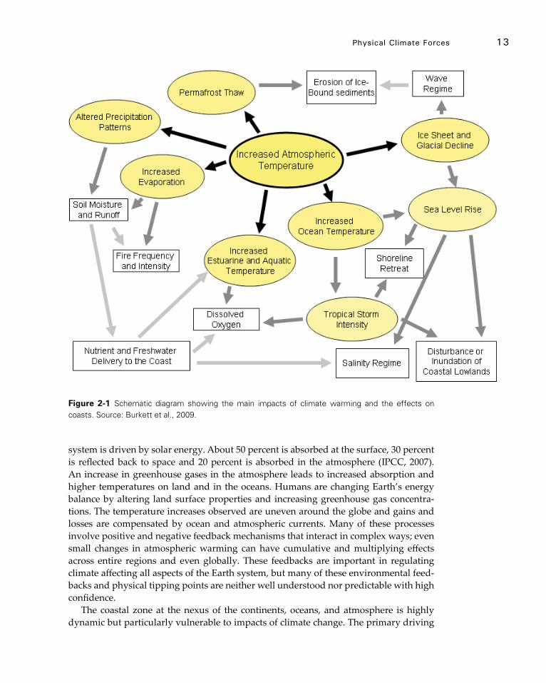
physical Climate Forces 13
system is driven by solar energy. About 50 percent is absorbed at the surface, 30 percent is reflected back to space and 20 percent is absorbed in the atmosphere (IPCC, 2007). An increase in greenhouse gases in the atmosphere leads to increased absorption and higher temperatures on land and in the oceans. Humans are changing Earth’s energy balance by altering land surface properties and increasing greenhouse gas concentra-tions. The temperature increases observed are uneven around the globe and gains and losses are compensated by ocean and atmospheric currents. Many of these processes involve positive and negative feedback mechanisms that interact in complex ways; even small changes in atmospheric warming can have cumulative and multiplying effects across entire regions and even globally. These feedbacks are important in regulating climate affecting all aspects of the Earth system, but many of these environmental feed-backs and physical tipping points are neither well understood nor predictable with high confidence.
The coastal zone at the nexus of the continents, oceans, and atmosphere is highly dynamic but particularly vulnerable to impacts of climate change. The primary driving
Figure 2-1 Schematic diagram showing the main impacts of climate warming and the effects on coasts. Source: Burkett et al., 2009.

14 CoAsTAl ImpACTs, AdApTATIon, And VUlnerAbIlITIes
forces are: sea-level rise; changes in temperature: precipitation; major storm events in-cluding waves, winds, and currents; and changing ocean circulation patterns.
This overview is focused on sea-level rise and its effects on the ocean coast of the U.S., including Alaska, Hawaii, and island territories. Although the Great Lakes are not dis-cussed, many of the same factors and conclusions about the effects of climate change are likely to apply. An exception is sea-level rise. Although oceans are likely to experience rising levels, the Great Lakes are predicted to experience dropping lake levels in the near future due to warming and increased evaporation. A drop in lake levels below historic levels has serious implications for the entire Great Lakes region for activities that rely on freshwater resources and commercial navigation.
Discussions of other climate change driving forces acting on coasts, such as sea-level rise scenario projections; extreme storm events; ocean waves, currents and ocean cir-culation; coastal vulnerability; changes in precipitation; and temperature increase are discussed in the subsequent Chapter 2 sections that follow.
Coastal Landforms and Coastal Change
The diverse landforms such as barrier islands and dunes, bluffs and cliffs, mainland beaches, deltas, estuaries and bays, and wetlands that comprise the U.S. coast are prod-ucts of a dynamic interaction between: 1) physical processes that act on the coast, includ-ing storms, waves, currents, sand sources and sinks, and relative sea level; 2) human activity such as dredging, dams, and coastal engineering; and 3) the geological character of the coast and nearshore. Variations of these physical processes in both location and time, as well as the local geology along the coast, result in the majority of the U.S. coast-lines undergoing overall long-term erosion at highly varying rates (CCSP, 2009a; Wil-liams et al., 2009). The complex interactions between these factors make the relationship between sea-level rise and shoreline change difficult to know. The difficulty in linking sea-level rise to coastal change results from the fact that shoreline change is not driven solely by sea-level rise. Instead, coasts are in dynamic balance and respond to many driving forces such as geological character, storm activity, and sediment supply in the coastal system. Surveys over the past century show that all U.S. coastal states are expe-riencing net long-term erosion at highly variable rates. Sea-level rise will have profound effects by increasing flooding frequency and inundating low-lying coastal areas, but other processes such as erosion and sediment accretion will have additional important effects on driving coastal change.
Many coastal landforms adjust to sea-level rise by growing vertically, migrating in-land, or expanding laterally. If the rate of sea-level rise accelerates significantly, coastal environments and human populations will be affected. In some cases, the effects will be limited in scope and similar to those observed during the last century. In other cases, thresholds may be crossed, beyond which the impacts would be much greater. If the sea rises more rapidly than the rate with which a particular coastal system can keep pace, it could fundamentally change the state of the coast. For example, rapid sea-level rise can cause rapid landward migration or segmentation of barrier islands, disintegration of wetlands, and drowning of coral reefs (CCSP, 2009a).
physical Climate Forces 15
Sea-level Rise and Effects on Coasts
Although climate has been highly variable and sea level has changed throughout Earth’s history, over the past approximately 6,000 years, global climate and sea level have been relatively stable with little variability and extremes. This benign climate has likely been a major factor in the rapid expansion of human population, which numbers 7 billion people currently, and the development of our modern society (Day et al., 2007). In the U.S., human population and development in coastal regions are substantial. Population continues to expand and people are increasingly at risk from global warming and a va-riety of natural hazards such as sea-level rise, storms, and flooding that may be exacer-bated by human-induced changes to global climate (Crossett et al., 2004; McGranahan et al., 2007; Nicholls et al., 2011).
Society should be concerned about current observations of sea-level rise and pro-jections of significant increases in decades ahead for two key reasons: 1) population densities have increased greatly and coasts have undergone intense development dur-ing a period of relatively stable sea level over the past century. Although, in theory, people could relocate landward to accommodate rising seas, human infrastructure, pri-vate land ownership, and current policy tend to prevent such adaptation measures. 2) Coastal landforms such as barrier islands, wetlands, and deltas are already dynamic and therefore highly vulnerable to sea-level rise. Many coastal urban areas including Boston, New York, Washington D.C., Norfolk, Charleston, Miami, New Orleans, San Francisco, and Honolulu are also at high risk, yet few coastal states and communities have plans for adaptation to warming temperatures, changes in storminess, and rising sea levels.
Coastal landforms are not simply inundated as sea level rises, but rather are modified by a variety of dynamic processes with cumulative effects that vary by location. Several conditions and driving forces influence coastal evolution in response to sea-level rise, as discussed by FitzGerald et al. (2008) and Williams and Gutierrez (2009):
• Geologic framework and character of coastal landforms;• Impacts of major storm events;• Coastal oceanographic processes acting on the coast;• Sediment supply to the coast by erosion and rivers and transport along the
coast; and• Human activity that alters sediment movement and increases erosion.
Geologic and historical records show large cyclical fluctuations in global sea level as-sociated with global climate change (Church et al., 2010, 2011; Hansen et al., 2007; IPCC, 2001; IPCC, 2007). For example, during the last interglacial warm period about 125,000 years ago when most of the world’s glaciers and many ice sheets on Greenland were depleted, sea level was approximately 6 to 8 meters higher than present (Kopp et al., 2009). In contrast, during the Last Glacial Maximum about 21,000 years ago when much of North America and northern Europe were thickly ice-covered, sea level was about 120 meters lower than present (see Figure 2-2) and much of present-day continental shelf ar-eas were exposed coastal plains (Fairbanks, 1989; Muhs et al., 2004). During the Ice Ages and lower sea level eras, rivers flowing across the coastal plain eroded large valleys. Subsequent sea-level rise submerged these river valleys, creating Long Island Sound,
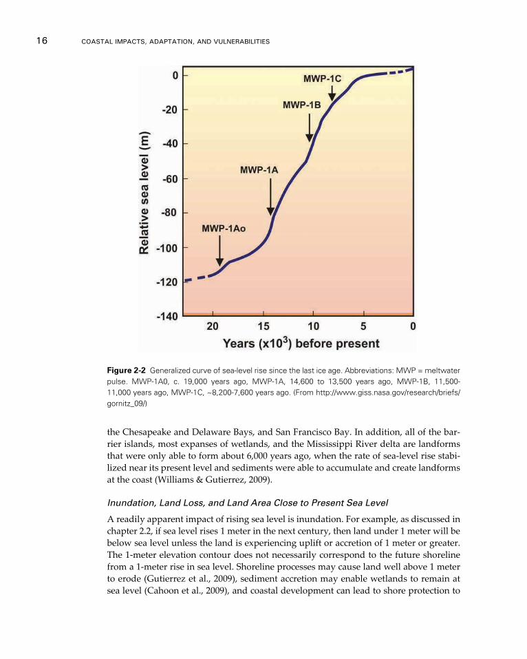
16 CoAsTAl ImpACTs, AdApTATIon, And VUlnerAbIlITIes
the Chesapeake and Delaware Bays, and San Francisco Bay. In addition, all of the bar-rier islands, most expanses of wetlands, and the Mississippi River delta are landforms that were only able to form about 6,000 years ago, when the rate of sea-level rise stabi-lized near its present level and sediments were able to accumulate and create landforms at the coast (Williams & Gutierrez, 2009).
Inundation, Land Loss, and Land Area Close to Present Sea Level
A readily apparent impact of rising sea level is inundation. For example, as discussed in chapter 2.2, if sea level rises 1 meter in the next century, then land under 1 meter will be below sea level unless the land is experiencing uplift or accretion of 1 meter or greater. The 1-meter elevation contour does not necessarily correspond to the future shoreline from a 1-meter rise in sea level. Shoreline processes may cause land well above 1 meter to erode (Gutierrez et al., 2009), sediment accretion may enable wetlands to remain at sea level (Cahoon et al., 2009), and coastal development can lead to shore protection to
Figure 2-2 Generalized curve of sea-level rise since the last ice age. Abbreviations: MWP = meltwater pulse. MWP-1A0, c. 19,000 years ago, MWP-1A, 14,600 to 13,500 years ago, MWP-1B, 11,500-11,000 years ago, MWP-1C, ~8,200-7,600 years ago. (From http://www.giss.nasa.gov/research/briefs/gornitz_09/)
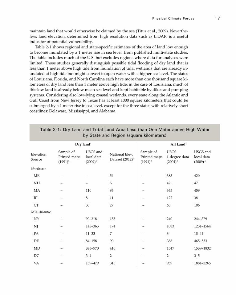
physical Climate Forces 17
maintain land that would otherwise be claimed by the sea (Titus et al., 2009). Neverthe-less, land elevation, determined from high resolution data such as LiDAR, is a useful indicator of potential vulnerability.
Table 2-1 shows regional and state-specific estimates of the area of land low enough to become inundated by a 1 meter rise in sea level, from published multi-state studies. The table includes much of the U.S. but excludes regions where data for analyses were limited. Those studies generally distinguish possible tidal flooding of dry land that is less than 1 meter above high tide from inundation of tidal wetlands that are already in-undated at high tide but might convert to open water with a higher sea level. The states of Louisiana, Florida, and North Carolina each have more than one thousand square ki-lometers of dry land less than 1 meter above high tide; in the case of Louisiana, much of this low land is already below mean sea level and kept habitable by dikes and pumping systems. Considering also low-lying coastal wetlands, every state along the Atlantic and Gulf Coast from New Jersey to Texas has at least 1000 square kilometers that could be submerged by a 1 meter rise in sea level, except for the three states with relatively short coastlines: Delaware, Mississippi, and Alabama.
Table 2-1: dry land and Total land Area less than one meter above High Water by state and region (square kilometers)
Dry land1 All Land2
Elevation Source
Sample of Printed maps (1991)3
USGS and local data (2009) 4
National Elev. Dataset (2012) 5
Sample of Printed maps (1991) 3
USGS 1-degree data (2001) 6
USGS and local data (2009) 4
Northeast
ME – – 54 – 383 420
NH – – 5 – 42 47
MA – 110 86 – 365 459
RI – 8 11 – 122 38
CT – 30 27 – 63 106
Mid-Atlantic
NY – 90–218 155 – 240 244–379
NJ – 148–365 174 – 1083 1231–1564
PA – 11–33 7 – 3 18–44
DE – 84–158 90 – 388 465–553
MD – 326–570 410 – 1547 1539–1832
DC – 3–4 2 – 2 3–5
VA – 189–479 315 – 969 1881–2265
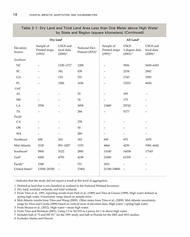
18 CoAsTAl ImpACTs, AdApTATIon, And VUlnerAbIlITIes
Table 2-1: dry land and Total land Area less than one meter above High Water by state and region (square kilometers)
Dry land1 All Land2
Elevation Source
Sample of Printed maps (1991)3
USGS and local data (2009) 4
National Elev. Dataset (2012) 5
Sample of Printed maps (1991) 3
USGS 1-degree data (2001) 6
USGS and local data (2009) 4
Southeast
NC – 1330–1717 1288 – 5836 5650–6343
SC – 341 439 – 2334 2842
GA – 133 331 – 1743 1993
FL – 1286 1654 – 12251 6624
Gulf
AL – – 35 – 195 –
MS – – 34 – 173 –
LA 3700 – 3058 13400 25742 –
TX – – 284 – 5177 –
Pacific
CA – – 378 – – –
OR – – 54 – – –
WA – – 289 – – –
Northeast 608 263 183 849 975 1070
Mid-Atlantic 3120 851–1827 1153 4466 4230 5381–6642
Southeast7 5800 3122 2885 13140 16038 17143
Gulf7 8200 4793 4238 21000 61355 –
Pacific8 2340 – 721 2431 – –United States8 13300–26700 – 13401 21100–54800 – –
– Indicates that the study did not report a result at this level of aggregation.
1 Defined as land that is not classified as wetland in the National Wetland Inventory.2 Dry land, nontidal wetlands, and tidal wetlands.3 From Titus et al., 1991, reporting results from Park et al., (1989) and Titus & Greene (1989). High water defined as spring high water. Uncertainty range based on sample error.4 Mid-Atlantic results from Titus and Wang (2009). Other states from Titus et al., (2009). Mid-Atlantic uncertainty range by Titus and Cacela (2009) based on vertical error of elevation data. High water = spring high water.5 From Strauss et al., (2012). High water = mean high water.6 From Titus and Richman (2001). Using 1.5 m NGVD as a proxy for 1 m above high water. 7 Includes half of “S and SW FL” for the 1991 study and half of Florida for the 2001 and 2012 studies.8 Excludes Alaska and Hawaii.
(Continued)
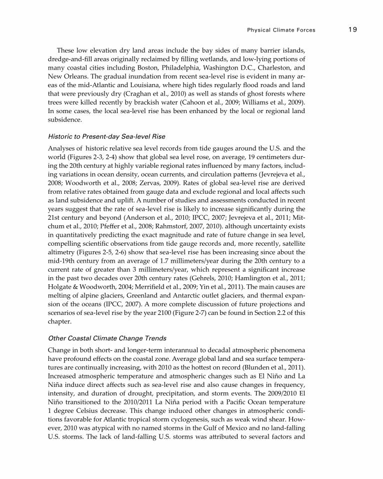
physical Climate Forces 19
These low elevation dry land areas include the bay sides of many barrier islands, dredge-and-fill areas originally reclaimed by filling wetlands, and low-lying portions of many coastal cities including Boston, Philadelphia, Washington D.C., Charleston, and New Orleans. The gradual inundation from recent sea-level rise is evident in many ar-eas of the mid-Atlantic and Louisiana, where high tides regularly flood roads and land that were previously dry (Craghan et al., 2010) as well as stands of ghost forests where trees were killed recently by brackish water (Cahoon et al., 2009; Williams et al., 2009). In some cases, the local sea-level rise has been enhanced by the local or regional land subsidence.
Historic to Present-day Sea-level Rise
Analyses of historic relative sea level records from tide gauges around the U.S. and the world (Figures 2-3, 2-4) show that global sea level rose, on average, 19 centimeters dur-ing the 20th century at highly variable regional rates influenced by many factors, includ-ing variations in ocean density, ocean currents, and circulation patterns (Jevrejeva et al., 2008; Woodworth et al., 2008; Zervas, 2009). Rates of global sea-level rise are derived from relative rates obtained from gauge data and exclude regional and local affects such as land subsidence and uplift. A number of studies and assessments conducted in recent years suggest that the rate of sea-level rise is likely to increase significantly during the 21st century and beyond (Anderson et al., 2010; IPCC, 2007; Jevrejeva et al., 2011; Mit-chum et al., 2010; Pfeffer et al., 2008; Rahmstorf, 2007, 2010). although uncertainty exists in quantitatively predicting the exact magnitude and rate of future change in sea level, compelling scientific observations from tide gauge records and, more recently, satellite altimetry (Figures 2-5, 2-6) show that sea-level rise has been increasing since about the mid-19th century from an average of 1.7 millimeters/year during the 20th century to a current rate of greater than 3 millimeters/year, which represent a significant increase in the past two decades over 20th century rates (Gehrels, 2010; Hamlington et al., 2011; Holgate & Woodworth, 2004; Merrifield et al., 2009; Yin et al., 2011). The main causes are melting of alpine glaciers, Greenland and Antarctic outlet glaciers, and thermal expan-sion of the oceans (IPCC, 2007). A more complete discussion of future projections and scenarios of sea-level rise by the year 2100 (Figure 2-7) can be found in Section 2.2 of this chapter.
Other Coastal Climate Change Trends
Change in both short- and longer-term interannual to decadal atmospheric phenomena have profound effects on the coastal zone. Average global land and sea surface tempera-tures are continually increasing, with 2010 as the hottest on record (Blunden et al., 2011). Increased atmospheric temperature and atmospheric changes such as El Niño and La Niña induce direct affects such as sea-level rise and also cause changes in frequency, intensity, and duration of drought, precipitation, and storm events. The 2009/2010 El Niño transitioned to the 2010/2011 La Niña period with a Pacific Ocean temperature 1 degree Celsius decrease. This change induced other changes in atmospheric condi-tions favorable for Atlantic tropical storm cyclogenesis, such as weak wind shear. How-ever, 2010 was atypical with no named storms in the Gulf of Mexico and no land-falling U.S. storms. The lack of land-falling U.S. storms was attributed to several factors and
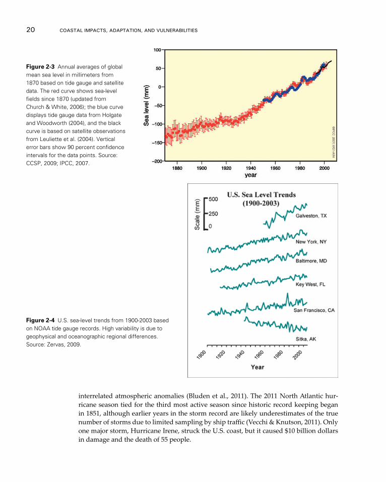
20 CoAsTAl ImpACTs, AdApTATIon, And VUlnerAbIlITIes
Figure 2-3 Annual averages of global mean sea level in millimeters from 1870 based on tide gauge and satellite data. The red curve shows sea-level fields since 1870 (updated from Church & White, 2006); the blue curve displays tide gauge data from Holgate and Woodworth (2004), and the black curve is based on satellite observations from Leuliette et al. (2004). Vertical error bars show 90 percent confidence intervals for the data points. Source: CCSP, 2009; IPCC, 2007.
Figure 2-4 U.S. sea-level trends from 1900-2003 based on NOAA tide gauge records. High variability is due to geophysical and oceanographic regional differences. Source: Zervas, 2009.
interrelated atmospheric anomalies (Bluden et al., 2011). The 2011 North Atlantic hur-ricane season tied for the third most active season since historic record keeping began in 1851, although earlier years in the storm record are likely underestimates of the true number of storms due to limited sampling by ship traffic (Vecchi & Knutson, 2011). Only one major storm, Hurricane Irene, struck the U.S. coast, but it caused $10 billion dollars in damage and the death of 55 people.
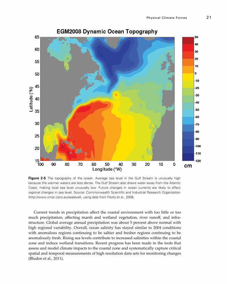
physical Climate Forces 21
Figure 2-5 The topography of the ocean. Average sea level in the Gulf Stream is unusually high because the warmer waters are less dense. The Gulf Stream also draws water away from the Atlantic Coast, making local sea level unusually low. Future changes in ocean currents are likely to affect regional changes in sea level. Source: Commonwealth Scientific and Industrial Research Organization (http://www.cmar.csiro.au/sealevel), using data from Pavlis et al., 2008.
Current trends in precipitation affect the coastal environment with too little or too much precipitation, affecting marsh and wetland vegetation, river runoff, and infra-structure. Global average annual precipitation was about 5 percent above normal with high regional variability. Overall, ocean salinity has stayed similar to 2004 conditions with anomalous regions continuing to be saltier and fresher regions continuing to be anomalously fresh. Rising sea levels contribute to increased salinities within the coastal zone and induce wetland transitions. Recent progress has been made in the tools that assess and model climate impacts to the coastal zone and systematically capture critical spatial and temporal measurements of high resolution data sets for monitoring changes (Bluden et al., 2011).
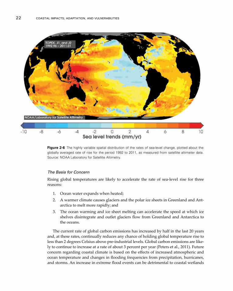
22 CoAsTAl ImpACTs, AdApTATIon, And VUlnerAbIlITIes
Figure 2-6 The highly variable spatial distribution of the rates of sea-level change, plotted about the globally averaged rate of rise for the period 1992 to 2011, as measured from satellite altimeter data. Source: NOAA Laboratory for Satellite Altimetry.
The Basis for Concern
Rising global temperatures are likely to accelerate the rate of sea-level rise for three reasons:
1. Ocean water expands when heated;2. A warmer climate causes glaciers and the polar ice sheets in Greenland and Ant-
arctica to melt more rapidly; and3. The ocean warming and ice sheet melting can accelerate the speed at which ice
shelves disintegrate and outlet glaciers flow from Greenland and Antarctica to the oceans.
The current rate of global carbon emissions has increased by half in the last 20 years and, at these rates, continually reduces any chance of holding global temperature rise to less than 2 degrees Celsius above pre-industrial levels. Global carbon emissions are like-ly to continue to increase at a rate of about 3 percent per year (Peters et al., 2011). Future concern regarding coastal climate is based on the effects of increased atmospheric and ocean temperature and changes in flooding frequencies from precipitation, hurricanes, and storms. An increase in extreme flood events can be detrimental to coastal wetlands

physical Climate Forces 23
that survive within a range of elevations, seasonal temperature, precipitation, and ebb and flood tides. For certain species, too much precipitation can have as much impact as too little precipitation can have. For example, for oysters, spawning is affected by too much freshwater in the spring and too much saltwater in the summer, both of which can induce diseases. An increase in extreme flooding and episodic events can increase tur-bidity, cause wetland loss, and induce stress to submerged plants and coral reefs.
Strong scientific consensus now suggests that the frequency of some climate extreme events is increasing and evidence exists that some extremes have increased as a result of anthropogenic influences (Peters et al., 2011). A December 2011 news release by NOAA reported that the U.S. experiences 12 disasters in 2011 that cost a billion or more dollars, totaling losses of about $53 billion. Several were coastal storms and the 2011 losses were greater than the previous record year in 2008. The global frequency of tropical storms is projected to remain about the same with an increase in the number of extreme events. “Average tropical cyclone maximum wind speed is likely to increase, although increases may not occur in all ocean basins. It is likely that the global frequency of tropical cy-clones will either decrease or remain essentially unchanged” (IPCC, 2011). Hurricanes and episodic storm events have been observed to have many direct physical impacts. These factors are likely to contribute to increased erosion, flooding, wetland loss, and damage to infrastructure.
2.2 Sea-level rise and Future Scenarios
Global sea-level rise is expected to continue through the end of the next century and beyond, which will significantly impact the U.S. and the world. Past trends provide valuable evidence in preparing for future environmental change but are insufficient by themselves for assessing the risks associated with an uncertain future. The wide range of estimates for global mean sea-level rise are scattered throughout the scientific literature and other high profile assessments such as previous reports of the NCA and the Inter-governmental Panel on Climate Change (IPCC). Currently, no coordinated, interagency effort exists in the U.S. to identify agreed upon global mean sea-level rise estimates for the purposes of coastal planning, policy, and management. This is an important gap because identifying global mean sea-level rise estimates is a critical step in assessing coastal impacts and vulnerabilities. At present, coastal managers are left to identify glob-al sea-level rise estimates through their own interpretations of scientific literature or the advice of experts on an adhoc basis. For these reasons, the NCA Development and Advi-sory Committee requested a report entitled Global Mean Sea-level Rise Scenarios for the U.S. NCA (Parris et al., 2012). This report provides a synthesis of the scientific literature on global sea-level rise and a set of global mean sea-level rise scenarios to describe fu-ture conditions and assess potential vulnerabilities and impacts.
Scenario Planning
Scenarios do not predict future changes; instead, they describe future potential condi-tions in a manner that supports decision-making under conditions of uncertainty (Gray 2011; Moss et al., 2010; Weeks et al., 2011). Scenarios are used to develop and test deci-sions under a range of plausible futures. This approach strengthens an organization’s
24 CoAsTAl ImpACTs, AdApTATIon, And VUlnerAbIlITIes
ability to recognize, adapt to, and take advantage of changes over time. Using a common set of scenarios across different regions and sectors to frame the range of uncertainties surrounding future environmental conditions is a relatively new NCA initiative. This report provides scenarios to help assessment experts and their stakeholders analyze the vulnerabilities and impacts associated with uncertain possible futures.
Probabilistic projections of future conditions are another form of scenarios not used in the Sea-level Rise Scenarios because this method remains an area of pending research (Parris et al., 2012). No widely accepted method is currently available for producing probabilistic projections of sea level rise at actionable regional and local scales. Coastal management decisions based solely on most probable or likely outcome can lead to mal-adapted or vulnerable assets (Gray, 2011; Weeks et al., 2011). Given the range of uncer-tainty in future global sea-level rise, using multiple scenarios, none more likely than the other, encourages experts and decision makers to consider multiple future conditions and to develop multiple response options. Scenario planning offers an opportunity to overcome decision-making paralysis and initiate actions now to reduce possible future impacts and vulnerabilities. Thus, specific probabilities or likelihoods are not assigned to individual scenarios, and none of these scenarios should be used in isolation.
Global Mean Sea-level Rise Scenarios
Based on numerous scientific studies, there is very high confidence (>9 in 10 chance) that global mean sea level will rise at least 0.2 meters and no more than 2.0 meters by 2100 (Parris et al., 2012). Global mean sea-level rise can be estimated from physical evidence such as observations of sea level and land ice variability (Pfeffer et al., 2008), expert judgment (NRC, 1987, 2011, 2012), general circulation models (GCMs) (IPCC, 2007a), and from semi-empirical methods that utilize both observations and general circulation models (Grinsted et al., 2009; Horton et al., 2008; Jevrejeva et al., 2010; Vermeer & Rahm-storf, 2009).
In recent decades, the dominant contributors to global sea-level rise have been ocean warming (thermal expansion) and ice sheet loss. Many previous studies, including the IPCC, assume thermal expansion to be the dominant contributor; however, the NRC (2012) recently reports that advances in satellite measurements indicate ice sheet loss as a greater contributor to global sea-level rise than thermal expansion over the period of 1993 to 2008. Our scenarios are based on four estimates of global sea-level rise by 2100 that reflect different degrees of ocean warming and ice sheet loss (Table 2-2 and Figure 2-7).
Key Uncertainties on the Global Sea-level Rise Scenarios
At this stage, the greatest uncertainty surrounding estimates of future global sea-level rise is the rate and magnitude of ice sheet loss, primarily from Greenland and West Ant-arctica. The Highest Scenario of global sea-level rise by 2100 is derived from a combina-tion of estimated ocean warming from the IPCC AR4 global sea-level rise projections and a calculation of the maximum possible glacier and ice sheet loss by the end of the century (Pfeffer et al., 2008). The Highest Scenario should be considered in situations where there is little tolerance for risk. Our Intermediate-High Scenario is based on an average of the high end of ranges of global mean SLR reported by several studies using
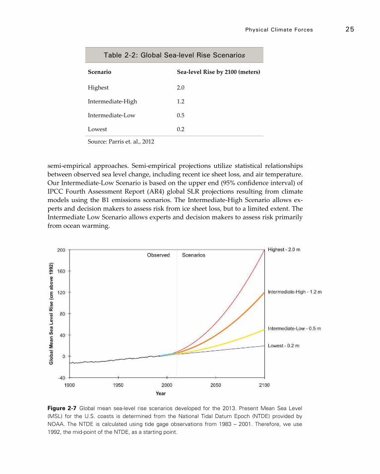
physical Climate Forces 25
Figure 2-7 Global mean sea-level rise scenarios developed for the 2013. Present Mean Sea Level (MSL) for the U.S. coasts is determined from the National Tidal Datum Epoch (NTDE) provided by NOAA. The NTDE is calculated using tide gage observations from 1983 – 2001. Therefore, we use 1992, the mid-point of the NTDE, as a starting point.
Table 2-2: Global sea-level rise scenarios
Scenario Sea-level Rise by 2100 (meters)
Highest 2.0
Intermediate-High 1.2
Intermediate-Low 0.5
Lowest 0.2
Source: Parris et. al., 2012
semi-empirical approaches. Semi-empirical projections utilize statistical relationships between observed sea level change, including recent ice sheet loss, and air temperature. Our Intermediate-Low Scenario is based on the upper end (95% confidence interval) of IPCC Fourth Assessment Report (AR4) global SLR projections resulting from climate models using the B1 emissions scenarios. The Intermediate-High Scenario allows ex-perts and decision makers to assess risk from ice sheet loss, but to a limited extent. The Intermediate Low Scenario allows experts and decision makers to assess risk primarily from ocean warming.
26 CoAsTAl ImpACTs, AdApTATIon, And VUlnerAbIlITIes
The Lowest Scenario is based on a linear extrapolation of the historical sea-level rise rate derived from tide gauge records beginning in 1900 (1.7 millimeters/year). The Low-est Scenario also coincides with the lower end (95% confidence interval) of the IPCC AR4 global sea-level rise projection derived from climate model simulations using the B1 emissions scenario. The rate of global mean sea-level rise derived from satellite altimetry (1992 to 2010) has been substantially higher (3.2 millimeters/year), approaching twice the rate of the longer historical record from tide gauges. The 18-year altimeter record is insufficient in duration for projecting century-scale global sea-level rise. Trends de-rived from the shorter records are less reliable as projections because they are affected by decadal and interannual climate and oceanographic patterns that are superimposed upon the long-term change of global sea level (Sallenger, 2012). The Lowest Scenario should only be considered where there is a great tolerance for risk.
Observations of global mean sea-level rise and increasing global mean temperature demonstrate highly significant correlation (Rahmstorf et al., 2011; Vermeer & Rahm-storf, 2009), and the IPCC (2007a) and more recent studies (Schaeffer et al., 2012) an-ticipate that global mean sea level will continue to rise even if warming declines. Our Intermediate-Low and Lowest Scenarios are optimistic scenarios of future environmen-tal change assuming limited ice sheet loss and historical rates of ocean warming (i.e., thermal expansion).
Ice Sheet Loss
Other studies (Rohling et al., 2008) have arrived at even greater estimates of global mean sea-level rise than the Highest Scenario, but we are less confident in the plausibility of those estimates in this century; however, we do recognize the plausibility of greater than 2 meter rise particularly beyond 2100. The IPCC AR4 produced some of the more widely used projections of global sea-level rise for the 21st century (IPCC, 2007a). The IPCC projections included thermal expansion, contributions from glaciers, and modeled partial ice sheet contributions among other factors; however, the IPCC AR4 estimates did not include potential rapid dynamic response of Greenland and Antarctic Ice Sheets as reflected in our Highest Scenario.
A growing body of recently published work suggests that, due to increasing loss, the great polar ice sheets in Greenland will become much more significant contributors to global sea-level rise in the future (NRC, 2012; Rignot et al., 2011; Van den Broeke et al., 2011; Vermeer & Rahmstorf, 2009). Ice sheet contributions to global mean sea-level rise stem from mass loss brought about by melting and discharge of ice into the ocean at marine-terminating glaciers and ice streams (NRC, 2012). Multiple reports indicate that mass loss of both the Greenland and Antarctic ice sheets may have accelerated over the past two decades despite high interannual variability in space and time (Chen et al., 2011; NRC, 2012; Rignot et al., 2011; Van den Broeke, 2011). Regional variability of mass loss for the Greenland ice sheet over the past few years shows that areas of accelerating deterioration changed from the southeast part of the ice sheet to the northwest part, sug-gesting high sensitivity of the Greenland ice sheet to regional climate (Chen et al., 2011). In Antarctica, ice loss is occurring in some coastal areas, and ice accumulation is occur-ring in interior Antarctica. While the balance between ice loss and accumulation remains an area of investigation, recent observations suggest that ice loss has been greater.
physical Climate Forces 27
Most of the ice loss in Antarctica has come from the West Antarctic ice sheet (Rignot et al., 2008). A significant portion of the West Antarctic ice sheet is floating at or ground-ed below sea level, as are relatively smaller parts of the ice sheets in East Antarctica and Greenland. Floating ice shelves support land-based ice sheets; thus, current and fu-ture ocean warming below the surface make ice shelves susceptible to catastrophic col-lapse, which, in turn, can trigger increased ice discharge to the ocean (Jacobs et al., 2011; Joughlin and Alley, 2011; Rignot et al., 2004; Scambos et al., 2004; Yin et al., 2011). Better understanding of how the polar ice sheets will respond to further changes in climatic conditions over the 21st century requires continued development of physical models (Price et al., 2011).
Ice sheet melting will lower the gravitational attraction ice sheets have for surround-ing seas, producing spatial variability in changes to global mean sea level (Kopp et al., 2010; Mitrovica et al., 2001, 2009). Although seemingly counterintuitive, sea level falls close to the ice sheets even though water from ice melt is discharged into the sea. This lowering of sea level is due to gravitational effects that can cause sea-level rise up to ~2,000 kilometers from the melting ice sheet. Sea-level rise resulting from deteriora-tion of the Greenland ice sheet is thought to be relatively lower than the global average for the contiguous U.S., Alaska, and U.S. territories in the Caribbean Sea and relatively higher for Hawaii and U.S. territories in the Pacific Ocean (Kopp et al., 2010). Sea-level rise resulting from deterioration of the West Antarctic ice sheet is thought to be rela-tively higher than the global average for all states and territories of the U.S. (Mitrovica et al., 2009).
Developing Regional and Local Scenarios
The development of sea-level change scenarios at global, regional, and local scales is an initial stage in conducting coastal vulnerability assessments. Parris et al. (2012) recom-mends that the choice of scenarios involve interdisciplinary scientific experts as well as coastal managers and planners who understand relevant decision factors. These sce-narios provide a set of plausible trajectories of global mean sea-level rise for use in as-sessing vulnerability, impacts, and adaptation strategies. None of these scenarios should be used in isolation, and experts and coastal managers should factor in locally and re-gionally specific information on climate, physical, ecological, and biological processes and on the culture and economy of coastal communities. The NOAA Coastal Services Center and the USGS also provide access to information via Digital Coast, including two companion reports on developing sea-level scenarios (NOAA, 2010, 2012).
Scientific observations at the local and regional scale are essential to action, but global phenomena such as sea-level rise can influence those conditions creating unanticipated impacts at the local scale, especially over longer time horizons. Thousands of structures along the U.S. coast are over fifty years old, including vital storm and waste water sys-tems. Thus, coastal vulnerability, impact, and adaptation assessments require an under-standing of the long-term, global, and regional drivers of environmental change.
2.3 extreme events and Future Scenarios
Variability of tropical cyclone frequency, track, and intensity is highly relevant to coastal
28 CoAsTAl ImpACTs, AdApTATIon, And VUlnerAbIlITIes
interests because of the associated risk of damage and loss of life during landfall events as well as the significant role that tropical cyclones can play in maintaining regional water resources (Jiang & Zipser, 2010). Atlantic tropical cyclone variability is closely cor-related with tropical Atlantic climate variability on a broad range of time-scales. A major challenge in detecting past trends in various measures of tropical cyclone activity is the need to identify the causal factors underpinning the observed Atlantic climate variabili-ty, which is required to separate tropical cyclone variability into naturally and anthropo-genically forced constituents. Even when regional climate variability can be attributed to anthropogenic causes, the question of how tropical cyclones respond to such variability remains. For example, studies have detected a tropical Atlantic sea surface temperature warming trend due to increasing greenhouse gases (Gillett et al., 2008; Karoly & Wu, 2005; Knutson et al., 2006; Santer et al., 2006), but the question of how tropical cyclones respond to sea surface temperature changes under global warming remains (Johnson & Xie, 2010; Knutson et al., 2008; Kunkel et al., 2011).
Detection of past trends in Atlantic tropical cyclone activity is also significantly con-strained by the quality of the historical data records (Knutson et al., 2010; Kunkel et al., 2011). Attempts to detect trends in landfalling tropical cyclone events are further constrained by the reduced data sample size associated with parsing of the data and are also substantially challenged by tropical cyclone track variability (Kossin & Camargo, 2009). This variability is driven largely by random fluctuations in atmospheric steer-ing currents and introduces substantial noise into time series of U.S. landfalling tropi-cal cyclone activity, which show no statistically significant long-term trends (Landsea, 2005; Vecchi & Knutson 2011). Atlantic tropical cyclone track variability is also driven by more systematic climatic forcings such as the El Niño-Southern Oscillation, North Atlan-tic Oscillation, Atlantic Meridional Mode, and Madden-Julian Oscillation (Kossin et al., 2010), but uncertainty still remains regarding how these modes of variability respond to climate change (Collins et al., 2010). Even modest tropical cyclone track variability can lead to large differences in associated coastal impacts. When compounded by uncertain-ties in the historical data, this severely challenges detection-attribution studies as well as disaster risk reduction in specific coastal regions. Only very low confidence can be of-fered that any trends in tropical cyclone activity reported within specific coastal regions are detectable.
Regarding global hurricane or tropical cyclone activity, an expert team of the World Meteorological Organization (Knutson et al., 2010) concluded that by the late 21st cen-tury, greenhouse warming would likely cause: 1) the global number of tropical cyclones to remain at current levels or to decrease by up to one-third; 2) the average intensity of tropical cyclones to increase by up to 10 percent; and 3) near-storm rainfall rates to increase by roughly 20 percent. For Atlantic basin tropical cyclone activity, the 21st cen-tury climate model projections summarized in Knutson and colleagues’ work (2010; and updated in Tables S1-S4 of this report) show a much larger range of uncertainty than the global projections. For example, the model projections from 14 studies for Atlantic tropical storm frequency for the late 21st century range from about a 60 percent increase to about a 60 percent decrease relative to current levels (Table S1). Thus, projections of the sign of Atlantic tropical storm frequency change are offered at very low confidence. Model or theoretical projections for Atlantic hurricane intensity range from an 8 per-cent decrease to a 14 percent increase (Table S3) with a clear tendency for an increase
physical Climate Forces 29
(low to moderate confidence). Models consistently projected increases of near-storm rain-fall rates (moderate confidence) with projections averaged within 100 kilometers of storm center ranging from about 5 percent to over 20 percent. These precipitation results were based on six studies reporting Atlantic basin results or multi-basin results that include the Atlantic and based on storms of tropical storm intensity or greater. Similar results for tropical cyclone frequency, intensity, and precipitation rates were reported for the Northeast Pacific basin, with tropical storm frequency projections ranging from about -70 percent to +80 percent (very low confidence in sign of change) and intensity changes ranging from about -5 percent to +20 percent (low to moderate confidence in an increase). Specific northeast Pacific region results have not been reported for near-storm precipita-tion rates, although relevant multi-basin studies report increases (moderate confidence) ranging from about +5 percent to over +20 percent.
Two dynamical modeling studies (Bender et al., 2010; Murakami et al., 2011) have explored present-day simulations and 21st century projections of intense Atlantic and/or Northeast Pacific hurricane frequency (category 4 and 5, with wind speeds exceeding 131 miles per hour or 210 kilometers/hour; or category 5, with wind speeds exceeding 155 miles per hour or 249 kilometers/hour). For the 21st century projections, both stud-ies use an average projected climate trend calculated from 18 different CMIP3 global climate models under an assumed A1B future emission scenario (Table S2). The Bender et al. (2010) study, using a regional model/case study approach, projects a 10 percent increase per decade (i.e., 100 percent increase over the 21st century) in Atlantic basin cat-egory 4-5 frequency, based on the multi-model ensemble climate change; however, not all of the individual models used to derive this value indicate an increase in frequency of Atlantic category 4-5 hurricanes. The Murakami et al. (2011) study (with auxiliary in-formation provided by Dr. H. Murakami, personal communication, 2011) projects a non-significant increase in category 4-5 storm days in the Atlantic basin (+15 percent) and globally (+4 percent) but a significant (+180 percent) increase in the NE Pacific basin. For category 5 storm days, their model projects significant increases (+56 percent globally, and +290 percent in the Atlantic basin). Several important caveats to these results should be noted. First, the Bender et al. (2010) model has a substantial (~50 percent) low bias in their simulation of Atlantic category 4-5 hurricane frequency under present climate con-ditions. Murakami et al. (2011) report a relatively small bias in their present-day simula-tion of Atlantic category 5 storm days but a large positive bias (almost a factor of 4) in their simulation of Atlantic category 4-5 storm days and a substantial low bias in NE Pacific category 4-5 storm days. In addition, the global model used by Murakami et al. does not include an interactive ocean component, in contrast to the regional case study model of Bender et al. In summary, we have low to moderate confidence in projections of an increase in intense hurricane frequency in the Atlantic basin.
A general caveat to available results reported here is the focus on basin-wide activ-ity measures, which do not necessarily correlate in an obvious way to coastal events because landfalling activity is intimately related to storm track variability, which itself is also linked to climate variability and change (Kossin et al., 2010). U.S. landfalling tropi-cal storm or hurricane activity in particular are explored in limited studies (Knutson et al., 2008; Villarini et al., 2011); thus, the above projections, and particularly those of intense hurricane activity, may be considered as early attempts at scenario development with respect to U.S. landfalling activity.
30 CoAsTAl ImpACTs, AdApTATIon, And VUlnerAbIlITIes
Exposure of coastal areas to devastating storm surge and waves will increase with the ever- increasing population that seeks to reside along the coast and its accompany-ing infrastructure. The storm surge threat will be exacerbated by relative sea-level rise and potentially by climate induced changes in frequency and intensity of hurricanes. As hurricanes approach the coast, four storm-related phenomena can occur to modify local water levels: set up due to wind, low barometric pressure, set up due to wave forcing, and rainfall. Storm winds force water towards the coast and typically create the greatest change in local water elevation. Low barometric pressure provides a secondary effect, creating a bulge in the water surface around the center of the storm. Wave forcing cre-ates an increase in the mean water level due to breaking waves at the coast. Storm rain-fall can also increase the local water elevation. Additional factors not related to the storm itself are the astronomical tide and river flows at the time the storm reaches the coast. Storm surges are also greatly influenced by the geometry of the basin and continental shelf leading up to the coastal floodplain. A mildly sloping continental shelf, such as in the Gulf of Mexico, results in a higher storm surge as compared to a coast with a steeper bathymetry.
Several recent studies (Irish et al., 2008; Irish & Resio, 2010; Resio et al., 2009) have shown that the maximum surge can be estimated as a function of several storm param-eters including storm intensity, size, and motion as well as the alongshore position of the point of interest relative to the landfall position. In general, the primary drivers of surge potential are storm intensity and size. Projected increases in storm intensity due to global warming will result in greater storm surge potential. Extensive studies with the numerical model ADCIRC (Westerink et al., 1992, 2007) indicate that, for small to mod-erately sized storms, peak alongshore surge increases about 30 centimeters per 10 mb of intensification. For large storms, peak alongshore surge increases about 40 centimeters per 10 mb (Irish et al., 2009).
Storm surge potential is also increased by global warming induced sea-level rise due to the mean water level increase as well as the complex interaction of storms and the coastal landscape. Data and numerical simulations have shown that landscape features and vegetation cover have the potential to reduce inland storm surge elevations along the coast by slowing the surge propagation (Wamsley et al., 2009, 2010). Elevations great-er than the storm surge elevation provide a physical barrier to the surge. Even when in-undated, landscape features and vegetation have the potential to create friction and slow the forward speed of the storm surge, effectively reducing inland water levels. Higher water levels resulting from sea-level rise can modify wetland vegetation type and may also lead to wetland loss, shoreline erosion, erosion of barrier islands through overwash and breaching, and an overall change in the local morphology such as islands trans-forming to submerged shoals and wetlands becoming open lakes or bays. Therefore, storm surge response does not increase linearly with sea-level rise in some coastal areas because of differences in slope of the coastal plain. Numerical simulations by Smith et al. (2010) indicate that for deltaic areas such as south Louisiana, the nonlinear response to sea-level rise is greatest in areas of modest surge (2-3 m). These areas may experience surges two to three times the amount of sea-level rise. Thus, in a statistical analysis of water levels, the long return period water levels would increase modestly above the sea-level rise, but shorter return period water levels could increase significantly.

physical Climate Forces 31
A number of recent studies have estimated the impact of sea-level rise on the fre-quency of extreme coastal inundation events due to storm passage. In a warming cli-mate, storm frequency, intensity, rainfall, and sea level are all projected to change, affecting storm inundation frequency and magnitude. Sea-level rise and storm-rainfall rate increases are the more robust projections as described above, and both can lead to increased surge and flooding. Kirshen et al. (2008) project sea-level rise onto time-series of past surge events in the U.S. Northeast to estimate that the 2005 100-year-event will become the 30-70 year event by 2050 depending on sea-level rise scenario. Larger changes are projected for particularly exposed locales such as Boston and Atlantic City. The Kirshen et al. analysis includes all surge sources, including tropical cyclones and nor’easters. Cayan et al. (2008) perform a related analysis for coastal California, obtain-ing large increases by mid-21st century in the annual number of hours with sea level above 99.99 percent of the historical values. Park et al. (2011) incorporate sea-level rise projections in statistical analysis of historic surge events on South Florida and find that the 50- year surge on Key West increases from 0.5 meters historically to 0.8-1.1 meters by 2060 depending on sea-level rise scenario. They find comparable changes elsewhere in South Florida.
Fewer studies have examined the impact of changes in tropical cyclone characteris-tics in addition to sea-level rise on flooding. Mousavi et al. (2010) estimate how surges on coastal Texas would increase with increases in hurricane intensity as well as sea-level rise by re-scaling key historical landfalling storms with an assumed 8 percent higher intensity through central pressure fall per degree Celsius of sea surface temperature increase. They estimate that, for a catastrophic storm event on Corpus Christi, based on a re-scaled Hurricane Carla, surge height will increase 0.2-0.5 meters by 2030 and 0.6-1.8 meters by 2080. Sea-level rise and increases in storm intensity have comparable contributions to the increases. Not included, however, is the impact of changing storm frequency, which would affect return periods.
Changes in storm risk along the coasts depends on changes in exposure, storm-related hazards, and coping mechanisms. If current coastal population and development trends continue, exposure to storm hazards such as surge, wind, or heavy rainfall will also increase in the next century, but projections of coping mechanisms such as improved building codes and restoration of wetland vegetation are much more uncertain. Any sea-level rise is virtually certain to exacerbate storm-related hazards, but projections of the magnitude of sea-level rise in specific regions (see also sections 2a,b above) can only be offered with low confidence and further uncertainties exist related to the effects of changes in storm-related hazards along the coasts. However, given the likelihood of con-tinued increases in exposure due to demographic pressure, and the likelihood of further increases in sea level, continues increases of storm-related risk along the coasts are likely in the 21st century.
2.4 Changes in Wave regimes and Circulation Patterns
Wave Regimes
Winds and waves control the flux of energy from the atmosphere to the ocean. Intense cyclones and associated episodes of high waves are important in transmitting the effects
32 CoAsTAl ImpACTs, AdApTATIon, And VUlnerAbIlITIes
of low-frequency climate variability to both the environment and society. The heights of waves generated by a storm depend on its wind speeds, the area over which the winds blow, also called the storm’s fetch, and on the duration of the storm, all factors that govern the amount of energy transferred to the waves. As they travel across the ocean basins, waves transport the energy they accumulated during storm events and dissi-pate it through many processes. Waves can significantly contribute to the dispersion of pollutants and the sorting of sediments on continental shelves. In nearshore regions, wave transformations induce gradients of radiation stresses, which result in longshore currents, rip-currents, and undertows. In particular, extreme storm events and associ-ated extreme wave heights can have negative effects on beaches, barrier islands, coastal structures, maritime works, ships, and coastal communities. A major concern for human society is whether external influences on the climate system, especially human influence, have affected storm and ocean wave climates in the past and whether wave climates will evolve under future climate scenarios.
Wave heights have been estimated from:
1. Visual observations from ships;2. Hindcast analyses;3. Direct measurements by buoys; and4. In recent years from satellite altimetry.
The reliability of the data ranges widely for these different sources depending on the collection methodology and processing techniques. Wave climates are most easily de-fined on coasts that are dominated by one type of storm system such as the North Pacific shore of the U.S., where the waves are generated by extratropical storms. The Atlantic shore of the U.S. has two wave climates: one climate consisting of waves from extratropi-cal storms such as nor’easters and the second being waves generated by tropical cyclones such as tropical storms and hurricanes. These two types of storm systems are fundamen-tally different in their modes of formation, largely separate seasons of dominance, and distinctive climate controls of their intensities and generated waves. They will therefore be considered separately in this section.
Extratropical Storm Waves
Extratropical storms are formed at relatively high latitudes by cold air masses moving down from subpolar regions and colliding with warmer air masses. The strongest storms develop during the winter. Considerable attention has been given to the occurrence in recent decades of increasing wave heights in both the North Atlantic and the Northeast Pacific generated by these storms.
In the Atlantic, the first positive documentation of wave-height increases by wave records was developed from the Seven Stones light vessel offshore from the southwest coast of England (Bacon & Carter, 1991; Carter & Draper, 1988) with a rate of increase in annual mean significant wave heights of about 2.2 centimeters/year. Wang et al. (2009) found that, in the winter, the observed 1955-2004 patterns in atmospheric storminess and ocean wave heights were characterized by an upward trend in the high-latitudes especially the northeast North Atlantic and by a downward trend in the mid-latitudes
physical Climate Forces 33
off the coast of the U.S. This result is supported by analyses of buoy data along the East Coast of the U.S. that did not find an increase for the winter wave heights (Komar & Al-lan, 2008). Wang et al. (2006, 2009) suggest that the changes in the North Atlantic wave climates are associated with the mean position of the storm track shifting about 181 ki-lometers northward. Gulev and Grigorieva (2006) analyzed wind wave climatologies derived from the visual wave observations of voluntary observing ship (VOS) officers. In both North Atlantic high latitudes and North Pacific mid latitudes, winter significant wave heights showed a secular increase from 10 to 40 centimeters per decade during the period 1958-2002. Statistical analysis showed that variability in wind sea is closely asso-ciated with the local wind speed, while swell changes can be driven by the variations in cyclone counts, implying the importance of forcing frequency for the resulting changes in significant wave heights (Gulev & Grigorieva, 2006).
Increases in wave heights have been found in the Northeast Pacific and documented by measurements from a series of NOAA buoys along the U.S. West Coast (Allan & Komar, 2000, 2006; Komar et al., 2009; Mendez et al., 2006, 2008; Ruggiero et al., 2010a; Seymour, 2011). Analyses by climatologists of North Pacific extra-tropical storms have concluded that their intensities, measured as wind velocities and atmospheric pressures, have increased since the late 1940s (Favre & Gershunov, 2006; Graham & Diaz, 2001), implying that the trends of increasing wave heights may have begun in the mid-20th century earlier than could be documented with the direct measurements of the waves by buoys.
However, the results of studies relying on solely on buoy measurements have re-cently been called into question after careful analyses of modifications of the wave mea-surement hardware as well as the analysis procedures since the start of the observations have demonstrated inhomogeneities in the records (Gemmrich et al., 2011). Accounting for these changes, trends for the corrected data are substantially smaller than the appar-ent trends obtained from the uncorrected data. Of interest, the most significant of the non-climatic step changes in the buoy records occurred prior to the mid 1980’s. Menen-dez et al. (2008) analyzed extreme significant wave heights along the northeast Pacific using data sets from 26 buoys over the period 1985-2007, not including the more sus-pect data from earlier in the buoy records. Application of their time-dependent extreme value model to significant wave heights showed significant positive long term trends in the extremes between 30-45° N near the western coast of the U.S. They further dem-onstrated an impact of El Niño on extreme wave heights in the northeast Pacific as well as important correlations with mid-latitudinal climate patterns such as NP and PNA indices. Mendez et al. (2010) extended this work by using two time-dependent extreme value models and three different datasets from buoys, satellite missions, and hindcast databases. Using reanalysis and buoy data, they conclude that the extreme wave climate in the NE Pacific is increasing in the period 1948-2008 at a rate of about 1 centimeter/year and 2-3 centimeters/year in the period 1985-2007.
Young et al. (2011) used a 23-year database of satellite altimeter measurements to investigate global changes in oceanic wind speed and wave height from 1985 to 2008. They found a general global trend of increasing wind speed and, to a lesser degree, wave height. For both winds and waves, the rate of increase is greater for extreme events as compared to the mean condition. Although wave heights showed no significant trend
34 CoAsTAl ImpACTs, AdApTATIon, And VUlnerAbIlITIes
for mean monthly values, at more extreme conditions (99th - percentile), a clear statisti-cally significant trend can be seen of increasing wave height at high latitudes including off the U.S. West and East Coasts and more neutral conditions in equatorial regions.
By analyzing monthly mean significant wave heights rather than extremes, Seymour (2011) also demonstrates a significant increase in wave energy affecting the West Coast of the U.S. during the interval of a 1984-2007. During the same period, a monotonic in-crease in the positive El Niño portion of the ENSO cycle and a monotonic decline in the atmospheric pressure in the Gulf of Alaska could be seen. Seymour (2011) speculates a possible connection between greenhouse gases and bigger waves in the North Pacific because both of these changes would be expected to produce higher wave energy levels and both have been identified as resulting, at least in part, from global climate change. However, Seymour (2011) clearly points out that the wave height record is too noisy and too short to establish an estimate of a possible contribution from the changes to global climate.
Research on trends in mid-latitude extra-tropical storms in the Eastern North Pacific have confirmed that storm intensity has increased but other research has documented a decrease in frequency, possibly because the storm tracks have shifted poleward during the latter half of the 20th century. McCabe et al. (2001) showed a statistically significant decrease in the frequency of storms over the years 1959-1997; however, Geng and Sugi (2003) found that the decrease in annual numbers of storms is typically of the weak-medium strength variety while the stronger storms have actually increased in frequency. These documented changes in storm tracks are thought to be primarily due to changes in baroclinicity, which in turn is linked to changes in atmospheric temperature distribu-tions due to increased greenhouse gas emissions. In other words, in the mid-latitudes of the Northern Hemisphere, poles are warming faster than lower latitudes , leading to a decrease in the meridional temperature gradient and a decrease in mid-latitude storm frequency. Recognizing the trends in reanalysis data, Yin (2005) used the output of 15 coupled general circulation models to relate the poleward shift of the storm track to changes in baroclinicity in the 21st century. Though these studies concluded that the storm track shifts poleward in the Northern Hemisphere with warmer temperatures, uncertainties remain regarding natural variability and model limitations.
Tropical Cyclone Generated Waves
Irish et al. (2011) have shown that historical observations of storm surges contain signifi-cant variations at the scale of the storm size, typically on the order of one or two times the radius to maximum winds or about 25-40 kilometers. For this reason, Irish et al. (2011) argued that historical observations alone may not be not good predictors of long-term climatological characteristics of surges in a coastal area. Wave fields tend to be a bit more dispersed, but extreme waves in hurricanes and tropical storms tend to exhibit similar characteristic scales of variation. In this context, long-term Global Climate Model simulations should offer a much better estimate of the impacts of climatic variations on future wave climates than attempts to used local observations; however, although many papers have discussed projections of future wave climates based on GCM simulations (Caires et al., 2006; Debenhard & Roed, 2008; Hemer et al., 2010; Mori et al., 2010; Ster-les & Caires, 2005; Wang et al., 2004; Wang & Swail, 2006), the numerical models used

physical Climate Forces 35
in these projections operate at spatial and temporal scales that make inferences about waves generated by tropical storms and hurricanes difficult to draw. The smallest scale used in these simulations is around 20 kilometers (Mori et al., 2010), which, although sufficient to resolve the dynamics of wave generation in extratropical storms, is only marginally sufficient to resolve them in tropical systems.
The Mori et al. (2010) study showed that waves simulated from the GCM ensembles in his study needed to be adjusted by about 5-15 percent to match observations in the present. They assumed that this adjustment would not change in future climates as well and chose to use the ratio of wave heights in future climates to the present climate as their indicator of the impact of climate variability on wave heights. They noted that the changes in wave climates around the globe showed different signatures for tropical and extratropical storm regimes and found no clear global trend in wave heights generated by tropical systems around the world. In areas analyzed in detail by Mori et al. (2010), the changes in wave heights were in the range of -5 percent to +15 percent between the present wave climate and the projected wave climate for 2100.
The expected changes in storm intensity in the Mori et al. (2010) study are in the same range as those discussed in a recent summary by Knutson et al. (2010). Knutson et al. (2010) examined the results of several recent studies and concluded that globally averaged tropical cyclone wind intensity is likely to increase with a projected range of 2 to 11 percent by 2100 among the different models (A1B scenario). Knutson et al. (2010) also concluded that global tropical cyclone frequency will either remain unchanged or decrease somewhat, by 6 to 34 percent, with future global warming by 2100. This range of potential changes in intensity and frequency, along with difficulties in the resolution of tropical systems for wave generation and early results that indicate that changes in tropically-generated wave climate may exhibit significant geographic variations make generalizations about potential impacts of climate variability on tropically-generated waves difficult to draw at present.
Impacts
If wave climates increase in the future, coastal infrastructure will come under increased risk to damage and inundation with impacted sectors including transportation and nav-igation; coastal engineering structures such as seawalls, riprap, and jetties; flood control and prevention structures; water supply and waste and storm water systems; and rec-reation, travel, and hospitality. Due to the dependence of wave runup, and therefore total water levels, on offshore wave characteristics, an increasing wave climate can sig-nificantly alter the frequency of flooding and erosion events along coastlines. Volumet-ric sediment transport rates are often formulated as nonlinear functions of wave height (Komar, 1998) and therefore small increases in wave heights can have impacts on trans-port rates, gradients in transport rates, and resulting morphological changes. Slott et al. (2006) found that moderate shifts in storminess patterns and the subsequent effect on wave climates could increase the rate at which shorelines recede or accrete to as much as several times the recent historical rate of shoreline change. On complex-shaped coast-lines, including cuspate-cape and spit coastlines, they found that the alongshore varia-tion in shoreline retreat rates could be an order of magnitude higher than the baseline retreat rate expected from sea-level rise alone over the coming century. Working on a
36 CoAsTAl ImpACTs, AdApTATIon, And VUlnerAbIlITIes
straight sandy coastline, Ruggiero et al. (2010b) applied a deterministic one-line shore-line change model in a quasi-probabilistic manner to test the effects of both wave climate and sediment supply variability on decadal-scale hindcasts and forecasts. Although their modeling exercises indicated that shoreline change is most sensitive to changes in wave direction, the effect of an increasingly intense future wave climate had significant impacts on erosion estimates.
However, at present we do not conclusively understand the climate controls on changing patterns of storminess and wave heights and therefore have relatively low con-fidence in our ability to project future trends in coastal storm impacts. For example, the magnitude and frequency of major El Niños has significant implications, but at this time we are unable to assess whether or not these will increase in the future due to climate change. Given the importance of waves along U.S. coastlines for essentially all planning and design considerations, more studies are needed to quantify these effects.
Ocean Circulation
Our understanding of the role of climate change in changing patterns of ocean circu-lation is relatively uncertain. Most studies to date have centered on the Atlantic basin because this is where ice melt in Greenland most directly affects key elements of the circulation. In this basin, the thermohaline circulation (THC) is manifested primarily through the meridional overturning circulation (MOC). Few direct measurements of the MOC exist, so quantifying the characteristics of its natural low-frequency variation is difficult. Instead, much of the variation is inferred from either indirect linkages to ocean temperature patterns, expected variations in stratification related to fresh water from ice melt, and coupled models of the atmosphere-ocean system (Latif et al., 2005). Us-ing reconstructed sea surface temperature datasets and century-long ocean and atmo-sphere reanalysis products, Wu et al. (2012) recently found that the post-1900 surface ocean warming rate over the path of subtropical western boundary currents, including the Gulf Stream, is two to three times faster than the global mean surface ocean warm-ing rate. The accelerated warming is associated with a synchronous poleward shift and/or intensification of global subtropical western boundary currents in conjunction with a systematic change in winds over both hemispheres. Wu et al. (2012) speculate that this enhanced warming may reduce the ability of the oceans to absorb anthropogenic carbon dioxide over these regions.
Increased freshwater inflows due to projections of Greenland Ice Sheet melting are expected to decrease the strength of the MOC due to changes in ocean salinity and tem-perature; however, as pointed out by Hu et al. (2009, 2011) the impact of this weakening will likely not significantly alter the strength of the MOC this century. Overall, these studies suggest that the combined effects of sea level due to both steric density changes and ocean dynamics might be significant in some regions of the world. The Hu et al. results are relatively consistent with the predictions of Yin et al. (2009) that indicate that the overall impact of steric and dynamic components of the ocean circulation on sea level might be in the range of 15-21 centimeters by the end of this century. However, as pointed out by Toggweiler and Russell (2008), the role of wind forcing on ocean circula-tion appears to be somewhat inconsistent with the historical observations, and because much of the ocean circulation is related directly or indirectly to wind forcing, resolving
physical Climate Forces 37
this difference in understanding the quantitative value of the current model predictions is important.
2.5 relative Vulnerability of Coasts
The key factors governing the relative vulnerability of U.S. coastal regions include the physical setting of specific areas, including their geology, geomorphology, and oceano-graphic characteristics, and the relevant climate and non-climate drivers. The coastline of the U.S. and its territories is highly diverse, ranging from arctic permafrost cliffs to mid-latitude barrier islands to low-lying tropical atolls. The broad geographic distribu-tion of U.S. and territorial coastal environments also means that climate and non-climate change drivers are similarly diverse, varying in form and magnitude at regional scales. Assessing coastal vulnerability in this context is challenging because of the many factors involved. Understanding how the coast will change in the future requires knowledge of physical, chemical, biological, and social processes that describe landscape and habitat changes and of societal adaptation abilities. Coastal vulnerability assessments thus re-quire a multidisciplinary approach that evaluates the joint probability of a wide variety of global change impacts and societal responses; however, current vulnerability assess-ments typically focus on only one variable such as elevation or rate of shoreline change.
Physical Setting
A number of studies have classified the physical setting of the U.S. coastal zone for pur-poses of developing vulnerability assessments (Gornitz, 1990, 1991; Shaw et al., 1998; Thieler & Hammar-Klose, 1999, 2000a, b). Variables such as geology, geomorphology, el-evation, shoreline change rate, sea-level rise rate, and wave and tide regime among oth-er factors are used to describe the coast according to increasing vulnerability to change due to sea-level rise. A simple mathematical formula relates the different variables and is used to calculate an index value. This method combines estimates of the coastal sys-tem’s susceptibility to change with its natural ability to adapt to changing environmen-tal conditions, yielding an objective, quantitative measure of the system’s vulnerability to sea-level rise. This approach has been applied to a number of locations worldwide; some applications include the addition of societal data and location-specific physical variables (Aboudha & Woodroffe, 2010; Boruff et al., 2005; Ozyurt & Ergin, 2010; Pend-leton et al., 2010).
Climate and Non-Climate Drivers
Coastal change is driven by a number of important factors (Table 2-3) that affect the landscape as well as biological systems such as wetlands and coral reefs. The climate drivers will have a non-uniform spatial and temporal influence across the U.S. and its territories. For example, the location of future ice-sheet melting (e.g., Greenland vs. Ant-arctica) will affect the gravitational distribution of water in the oceans, such that some areas far from the meltwater source will experience greater sea-level rise (Bamber et al., 2009; Mitrovica et al., 2009; Riva et al., 2010). Regional variations in ocean warming and circulation may also enhance or reduce the amount of sea-level rise along the coast (Hu et al., 2008; Yin et al., 2009). Other climate drivers such as CO
2 concentration may change
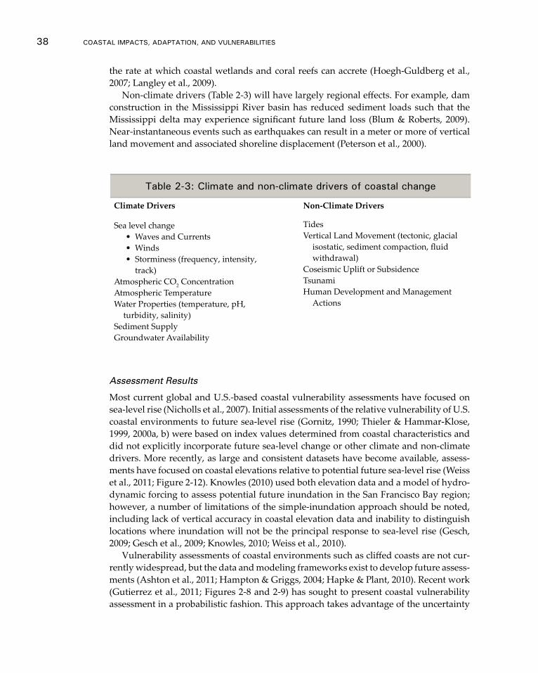
38 CoAsTAl ImpACTs, AdApTATIon, And VUlnerAbIlITIes
the rate at which coastal wetlands and coral reefs can accrete (Hoegh-Guldberg et al., 2007; Langley et al., 2009).
Non-climate drivers (Table 2-3) will have largely regional effects. For example, dam construction in the Mississippi River basin has reduced sediment loads such that the Mississippi delta may experience significant future land loss (Blum & Roberts, 2009). Near-instantaneous events such as earthquakes can result in a meter or more of vertical land movement and associated shoreline displacement (Peterson et al., 2000).
Assessment Results
Most current global and U.S.-based coastal vulnerability assessments have focused on sea-level rise (Nicholls et al., 2007). Initial assessments of the relative vulnerability of U.S. coastal environments to future sea-level rise (Gornitz, 1990; Thieler & Hammar-Klose, 1999, 2000a, b) were based on index values determined from coastal characteristics and did not explicitly incorporate future sea-level change or other climate and non-climate drivers. More recently, as large and consistent datasets have become available, assess-ments have focused on coastal elevations relative to potential future sea-level rise (Weiss et al., 2011; Figure 2-12). Knowles (2010) used both elevation data and a model of hydro-dynamic forcing to assess potential future inundation in the San Francisco Bay region; however, a number of limitations of the simple-inundation approach should be noted, including lack of vertical accuracy in coastal elevation data and inability to distinguish locations where inundation will not be the principal response to sea-level rise (Gesch, 2009; Gesch et al., 2009; Knowles, 2010; Weiss et al., 2010).
Vulnerability assessments of coastal environments such as cliffed coasts are not cur-rently widespread, but the data and modeling frameworks exist to develop future assess-ments (Ashton et al., 2011; Hampton & Griggs, 2004; Hapke & Plant, 2010). Recent work (Gutierrez et al., 2011; Figures 2-8 and 2-9) has sought to present coastal vulnerability assessment in a probabilistic fashion. This approach takes advantage of the uncertainty
Table 2-3: Climate and non-climate drivers of coastal change
Climate Drivers Non-Climate Drivers
Sea level change• Waves and Currents• Winds• Storminess (frequency, intensity,
track)Atmospheric CO2 ConcentrationAtmospheric TemperatureWater Properties (temperature, pH,
turbidity, salinity)Sediment SupplyGroundwater Availability
TidesVertical Land Movement (tectonic, glacial
isostatic, sediment compaction, fluid withdrawal)
Coseismic Uplift or SubsidenceTsunamiHuman Development and Management
Actions
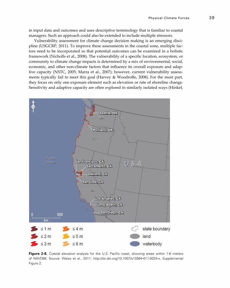
physical Climate Forces 39
in input data and outcomes and uses descriptive terminology that is familiar to coastal managers. Such an approach could also be extended to include multiple stressors.
Vulnerability assessment for climate change decision making is an emerging disci-pline (USGCRP, 2011). To improve these assessments in the coastal zone, multiple fac-tors need to be incorporated so that potential outcomes can be examined in a holistic framework (Nicholls et al., 2008). The vulnerability of a specific location, ecosystem, or community to climate change impacts is determined by a mix of environmental, social, economic, and other non-climate factors that influence its overall exposure and adap-tive capacity (NSTC, 2005; Marra et al., 2007); however, current vulnerability assess-ments typically fail to meet this goal (Harvey & Woodroffe, 2008). For the most part, they focus on only one exposure element such as elevation or rate of shoreline change. Sensitivity and adaptive capacity are often explored in similarly isolated ways (Hinkel,
Figure 2-8. Coastal elevation analysis for the U.S. Pacific coast, showing areas within 1-6 meters of NAVD88. Source: Weiss et al., 2011; http://dx.doi.org/10.1007/s10584-011-0024-x, Supplemental Figure 2.
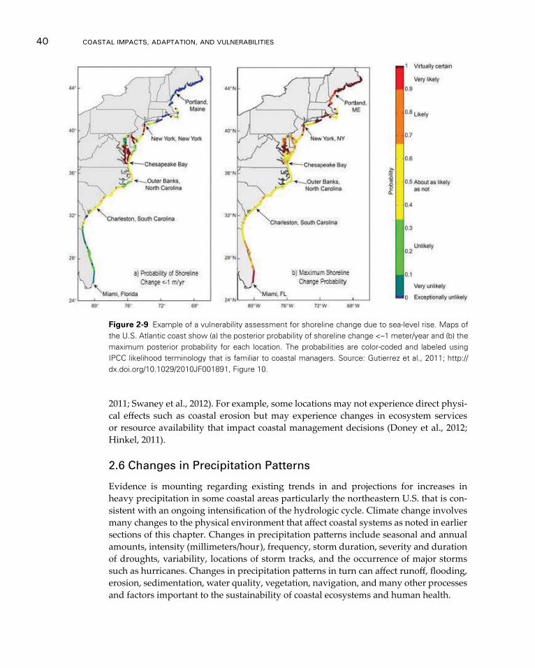
40 CoAsTAl ImpACTs, AdApTATIon, And VUlnerAbIlITIes
2011; Swaney et al., 2012). For example, some locations may not experience direct physi-cal effects such as coastal erosion but may experience changes in ecosystem services or resource availability that impact coastal management decisions (Doney et al., 2012; Hinkel, 2011).
2.6 Changes in Precipitation Patterns
Evidence is mounting regarding existing trends in and projections for increases in heavy precipitation in some coastal areas particularly the northeastern U.S. that is con-sistent with an ongoing intensification of the hydrologic cycle. Climate change involves many changes to the physical environment that affect coastal systems as noted in earlier sections of this chapter. Changes in precipitation patterns include seasonal and annual amounts, intensity (millimeters/hour), frequency, storm duration, severity and duration of droughts, variability, locations of storm tracks, and the occurrence of major storms such as hurricanes. Changes in precipitation patterns in turn can affect runoff, flooding, erosion, sedimentation, water quality, vegetation, navigation, and many other processes and factors important to the sustainability of coastal ecosystems and human health.
Figure 2-9 Example of a vulnerability assessment for shoreline change due to sea-level rise. Maps of the U.S. Atlantic coast show (a) the posterior probability of shoreline change <–1 meter/year and (b) the maximum posterior probability for each location. The probabilities are color-coded and labeled using IPCC likelihood terminology that is familiar to coastal managers. Source: Gutierrez et al., 2011; http://dx.doi.org/10.1029/2010JF001891, Figure 10.
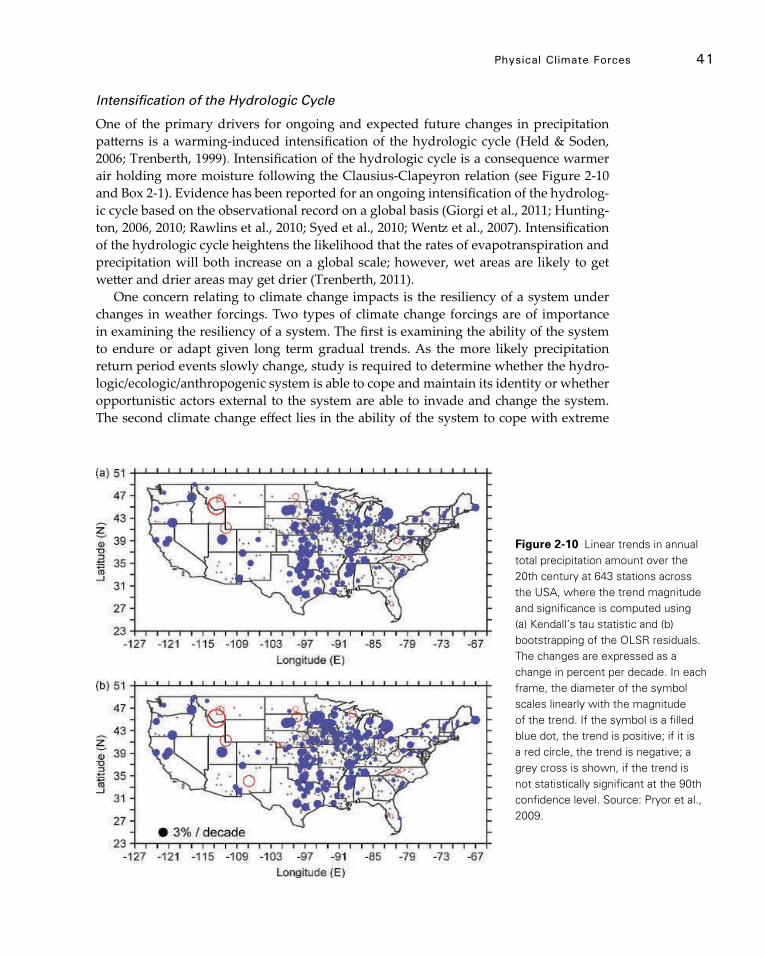
physical Climate Forces 41
Intensification of the Hydrologic Cycle
One of the primary drivers for ongoing and expected future changes in precipitation patterns is a warming-induced intensification of the hydrologic cycle (Held & Soden, 2006; Trenberth, 1999). Intensification of the hydrologic cycle is a consequence warmer air holding more moisture following the Clausius-Clapeyron relation (see Figure 2-10 and Box 2-1). Evidence has been reported for an ongoing intensification of the hydrolog-ic cycle based on the observational record on a global basis (Giorgi et al., 2011; Hunting-ton, 2006, 2010; Rawlins et al., 2010; Syed et al., 2010; Wentz et al., 2007). Intensification of the hydrologic cycle heightens the likelihood that the rates of evapotranspiration and precipitation will both increase on a global scale; however, wet areas are likely to get wetter and drier areas may get drier (Trenberth, 2011).
One concern relating to climate change impacts is the resiliency of a system under changes in weather forcings. Two types of climate change forcings are of importance in examining the resiliency of a system. The first is examining the ability of the system to endure or adapt given long term gradual trends. As the more likely precipitation return period events slowly change, study is required to determine whether the hydro-logic/ecologic/anthropogenic system is able to cope and maintain its identity or whether opportunistic actors external to the system are able to invade and change the system. The second climate change effect lies in the ability of the system to cope with extreme
Figure 2-10 Linear trends in annual total precipitation amount over the 20th century at 643 stations across the USA, where the trend magnitude and significance is computed using (a) Kendall’s tau statistic and (b) bootstrapping of the OLSR residuals. The changes are expressed as a change in percent per decade. In each frame, the diameter of the symbol scales linearly with the magnitude of the trend. If the symbol is a filled blue dot, the trend is positive; if it is a red circle, the trend is negative; a grey cross is shown, if the trend is not statistically significant at the 90th confidence level. Source: Pryor et al., 2009.
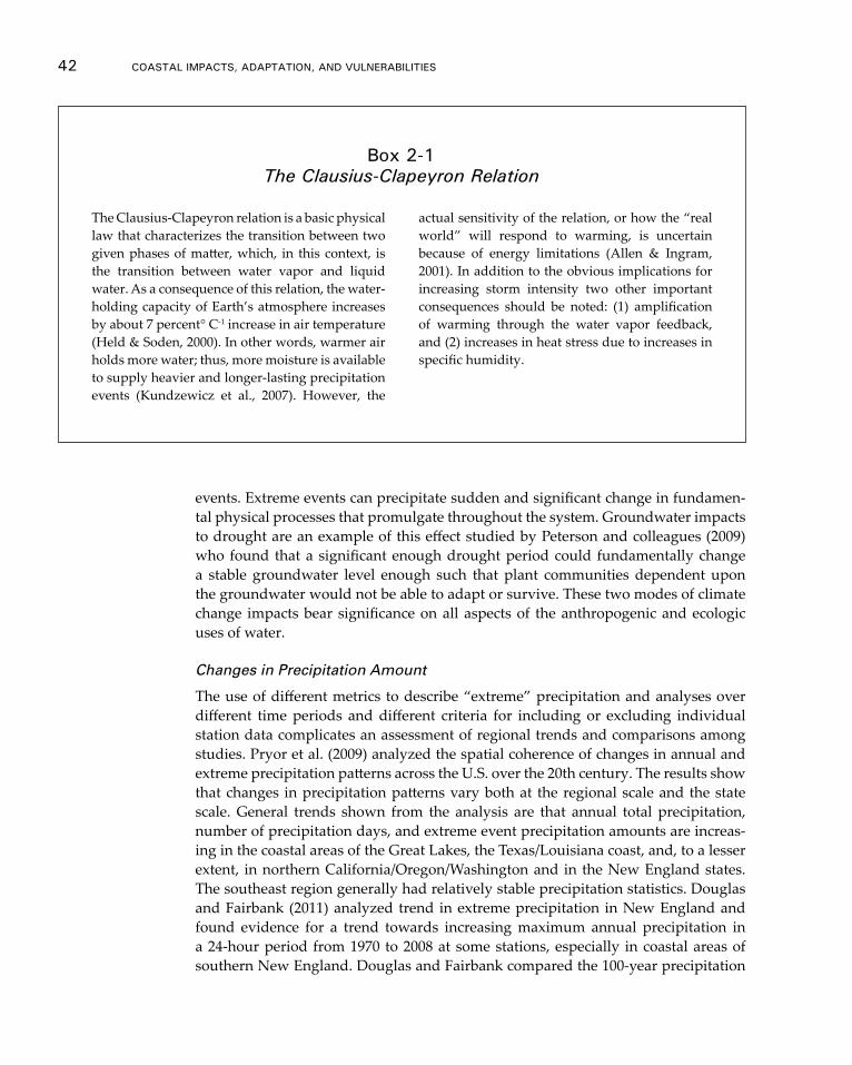
42 CoAsTAl ImpACTs, AdApTATIon, And VUlnerAbIlITIes
The Clausius-Clapeyron relation is a basic physical law that characterizes the transition between two given phases of matter, which, in this context, is the transition between water vapor and liquid water. As a consequence of this relation, the water-holding capacity of Earth’s atmosphere increases by about 7 percent° C-1 increase in air temperature (Held & Soden, 2000). In other words, warmer air holds more water; thus, more moisture is available to supply heavier and longer-lasting precipitation events (Kundzewicz et al., 2007). However, the
actual sensitivity of the relation, or how the “real world” will respond to warming, is uncertain because of energy limitations (Allen & Ingram, 2001). In addition to the obvious implications for increasing storm intensity two other important consequences should be noted: (1) amplification of warming through the water vapor feedback, and (2) increases in heat stress due to increases in specific humidity.
box 2-1 The Clausius-Clapeyron Relation
events. Extreme events can precipitate sudden and significant change in fundamen-tal physical processes that promulgate throughout the system. Groundwater impacts to drought are an example of this effect studied by Peterson and colleagues (2009) who found that a significant enough drought period could fundamentally change a stable groundwater level enough such that plant communities dependent upon the groundwater would not be able to adapt or survive. These two modes of climate change impacts bear significance on all aspects of the anthropogenic and ecologic uses of water.
Changes in Precipitation Amount
The use of different metrics to describe “extreme” precipitation and analyses over different time periods and different criteria for including or excluding individual station data complicates an assessment of regional trends and comparisons among studies. Pryor et al. (2009) analyzed the spatial coherence of changes in annual and extreme precipitation patterns across the U.S. over the 20th century. The results show that changes in precipitation patterns vary both at the regional scale and the state scale. General trends shown from the analysis are that annual total precipitation, number of precipitation days, and extreme event precipitation amounts are increas-ing in the coastal areas of the Great Lakes, the Texas/Louisiana coast, and, to a lesser extent, in northern California/Oregon/Washington and in the New England states. The southeast region generally had relatively stable precipitation statistics. Douglas and Fairbank (2011) analyzed trend in extreme precipitation in New England and found evidence for a trend towards increasing maximum annual precipitation in a 24-hour period from 1970 to 2008 at some stations, especially in coastal areas of southern New England. Douglas and Fairbank compared the 100-year precipitation
physical Climate Forces 43
depth quantiles for the 1954-2005 record with NOAA’s Technical Paper No. 40 (NOAA, 1961) 100-year, 24-hour precipitation values. Estimates for stations along coastal Mas-sachusetts, New Hampshire, and Maine all exceeded 7 inches and exceeded TP-40 by 1 inch or more. These findings indicate that TP-40 under represents coastal-storm depths.
Observed long-term trends in annual precipitation amounts in coastal areas of the U.S. are quite variable. Generally, between 1958 and 2007, increases were observed in California, the northeastern states, the Great Lakes, the Gulf Coast of Texas, and Loui-siana, and decreases were observed in the Pacific Northwest and in the southeastern U.S. (GCCI, 2009). Hodgkins and Dudley (2007) reported increases in precipitation and runoff in the Great Lakes Basin during 1915 to 2004. In 1958-2007, the largest increases in heavy precipitation occurred in the northeastern states and surrounding the Great Lakes (GCCI, 2009). Significant increases in heavy daily precipitation above the 99.7th percentile during 1908 to 2000 on an annual basis occurred in the Great Lakes region and the Gulf of Mexico coastal regions throughout Texas to Louisiana and in the winter in the northeastern states (Groisman et al., 2004). Increases in extreme rainfall in the Great Lakes regions also were reported by Kling et al. (2003) for the period of 1931 to 1996.
Changes in precipitation amount annually and seasonally will influence stream and river runoff as well as the potential for flooding and drought. Changes in the volume, timing, and quality of available water may increase the vulnerability of water supplies and water quality (Aggarwal & Singh, 2010; Buonaiuto et al., 2010; Delpla et al., 2009; Park et al., 2010; Whitehead et al., 2009). Increasing runoff can reduce salinity in es-tuaries and the near-coastal ocean, which, when coupled with warmer surface water, increases the difference in density between surface and bottom waters, thus preventing the replacement of oxygen in the deeper waters (GCCI, 2009).
Extreme precipitation events can have many impacts on the integrity of coastal wet-land systems, including direct effects on vegetation that have indirect effects on wetland geomorphology by affecting stability of soils and the erosion, transport, and deposition of sediments (Cahoon, 2006). Extreme precipitation can cause local rivers to jump their channels and carve new channels through the upland, mobilizing millions of tons of sediment that are deposited in downstream wetlands, which occurred in the Tijuana River during the 1993 El Niño storm in southern California (Cahoon et al., 1996).
Late 21st century projections of precipitation changes for the winter and summer seasons from the CMIP3 models are shown in the IPCC AR4 (see Fig. 10.9 and TS.30 of the Working Group I report). Those results suggest that making confident projections of regional precipitation changes over the U.S. is difficult. The most robust global changes include a tendency for increased precipitation in high latitudes and decreased precipita-tion in many parts of the subtropical dry zones around the globe. On the other hand, the continental U.S. tends to lie between these two broad zones, leading to lower confidence in precipitation projections than for some other regions around the globe. The highest level of model agreement for the U.S. is the projection of an increase in precipitation in the Alaska region. Washington and Oregon lie in a relatively small region of high inter-model agreement on reduced summertime precipitation. Most of the CMIP3 mod-els project increased winter precipitation along the Northeast coastal regions of the U.S.
In a recent study of the Great Lakes region, climate model projections indicated increases in winter and spring precipitation of up to 20 percent under lower and 30
44 CoAsTAl ImpACTs, AdApTATIon, And VUlnerAbIlITIes
percent under higher emissions scenarios by the end of the 21st century, while projec-tions for summer and fall were inconsistent. Competing effects of shifting precipitation and warmer temperatures suggested little change in Great Lake levels over much of the century until the end of the century, when net decreases were projected under higher emissions (Hayhoe et al., 2010).
Increasing Variability in Precipitation
An increase in the spatial and temporal variability and the amount of precipitation will result in major challenges for water resource managers. Most water resource manage-ment infrastructure and planning is based on assumptions of stationarity and the con-cept that historical variability in precipitation can be used to predict future variability in the design and management of water systems (Milly et al., 2008). If climate change is accompanied by substantial changes in the variability of precipitation as is projected (Bates et al., 2008; Gutowski et al., 2008), water resource availability will be affected un-less resource managers develop adaption plans that can accommodate such changes. The historical record suggests that variability is increasing (Madsen & Figdor, 2007; Medvigy & Beaulieu, 2012; Tebaldi et al., 2006). Pryor et al. (2009) analyzed eight met-rics of precipitation in century-long records throughout the contiguous U.S. and found that statistically significant trends generally indicated increases in the intensity of events above the 95th percentile. Medvigy and Beaulieu (2012) reported changes between 1997 and 2007 in variability in daily precipitation amount for some U.S. regions. Increases in variability were reported for coastal New England, Washington state, Hawaii, and most of coastal Alaska, and decreases were reported for parts of southeastern and south-western continental U.S. Studies indicate medium high confidence in the range of 67 to 90 percent probability that variability in the amount, intensity, and spatial distribution of precipitation, especially in extreme weather events will increase in the 21st century (Bates et al., 2008; Gutowski et al., 2008).
Changes in Ratio of Snow to Total Precipitation
Studies show that the ratio of snow to total precipitation has decreased in the northeast-ern U.S. (Huntington et al., 2004), northwestern U.S. (Knowles et al., 2006), and in the Alaskan Arctic region (Screen & Simmonds, 2011). These changes have implications for the timing and volume of spring runoff during the snowmelt period.
Changes in Precipitation in Coastal Alaska
Sparse historical records for total precipitation indicate that trends in Alaska vary by region and time period but do not show major trends in total annual amounts as have been reported over many areas of the contiguous U.S. (GCCI, 2009; Kunkel et al., 2008; Muskett & Romanovsky, 2011). Arctic regions have experienced decreases in snowfall amounts in recent decades (Derksen & Brown, 2011) and decreases in the fraction of total precipitation occurring as snow (Screen & Simmonds, 2011). Mixed results have been reported for changes in frequency of heavy precipitation events in Alaska; how-ever, more increasing trends have appeared since 1980, especially in southern Alaska (Stewart, 2011). Climate projections for Alaska indicate high confidence in increasing

physical Climate Forces 45
precipitation and increasing frequency of heavy precipitation (IPCC AR4 WGII, 2007; IPCC, 2011). Changes in precipitation regime could influence permafrost temperature, which has generally been increasing in Alaska (Derksen & Brown, 2011; Osterkamp, 2007; Smith et al., 2010), thus affecting soil water content (Muskett & Romanovsky, 2011) and presumably the stability of permafrost in coastal regions (Buonaiuto et al., 2010).
Changes in Storm Tracks
According to the recently released summary of the IPCC report on extreme events (IPCC, 2011: pg. 5), “It is likely that there has been a poleward shift in the main Northern and Southern Hemisphere extra-tropical storm tracks.” As a result, some regions will ex-perience increased or decreased storm frequency due to the poleward shift of the tracks. According to a recent assessment report on tropical cyclones and climate change (Knut-son et al., 2010: pg. 2), there is “low confidence in projected changes in tropical cyclone genesis location, tracks, duration, and areas of impact.” Existing model projections do not show dramatic large-scale changes in these features.
Droughts
An increase in the proportion of land area in drought since the 1970s is reported by Burke et al. (2006). Dai et al. (2004) reported increases in the area in both drought and wet areas in the conterminous U.S. Trends are highly variable among regions and are attributed to both ENSO-induced decreases in precipitation and to warming-induced in-creases in evaporation. The changes are consistent with increasing risk of more frequent and more intense drought over some regions (Dai et al., 2004). During 1967 to 2006, the mean duration of prolonged dry episodes, 1 month or longer in the eastern U.S. and 2 months or longer in the southwestern U.S., has significantly increased (Groisman & Knight, 2008). Increasing drought in some coastal areas could lead to water shortages and soil moisture deficits, called agricultural drought, leading to reduced crop yield, greater risk of wildfire, and greater susceptibility to some pests (Hatfield et al., 2008). In some regions drought will likely be compounded by higher rates of evapotranspira-tion, which could result in increased groundwater withdrawals because of higher water demands (Hatfield et al., 2008). Cumulatively, these climatic changes, sea-level rise, and human adaptations could result in depletion of coastal aquifers and saltwater intrusion (Conrads et al., 2010).
Heavy Rainfall and Floods
Climate change has the potential to substantially affect risk of flooding and associated impacts to human health, infrastructure, and agriculture. Coastal U.S. cities have far lower populations at risk than cities in Southeast Asia, but New York and Miami rank highly in assets exposed to risks from storm and flood damage (Hanson et al., 2011). Floods can cause population- and community-level changes in ecosystems superim-posed on a background of more gradual trends (Thibault & Brown, 2008). Saltmarshes, mangroves, and coral reefs are expected to be particularly vulnerable to impacts of ex-treme events associated with major coastal storms (Bertness & Ewanchuk, 2002; Fischlin et al., 2007; Hughes et al., 2003). Heavier rainfall, combined with sea-level rise and storm
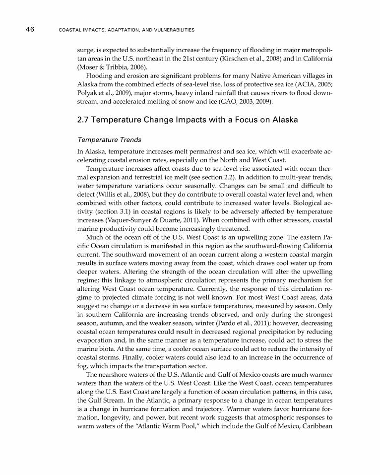
46 CoAsTAl ImpACTs, AdApTATIon, And VUlnerAbIlITIes
surge, is expected to substantially increase the frequency of flooding in major metropoli-tan areas in the U.S. northeast in the 21st century (Kirschen et al., 2008) and in California (Moser & Tribbia, 2006).
Flooding and erosion are significant problems for many Native American villages in Alaska from the combined effects of sea-level rise, loss of protective sea ice (ACIA, 2005; Polyak et al., 2009), major storms, heavy inland rainfall that causes rivers to flood down-stream, and accelerated melting of snow and ice (GAO, 2003, 2009).
2.7 Temperature Change Impacts with a Focus on Alaska
Temperature Trends
In Alaska, temperature increases melt permafrost and sea ice, which will exacerbate ac-celerating coastal erosion rates, especially on the North and West Coast.
Temperature increases affect coasts due to sea-level rise associated with ocean ther-mal expansion and terrestrial ice melt (see section 2.2). In addition to multi-year trends, water temperature variations occur seasonally. Changes can be small and difficult to detect (Willis et al., 2008), but they do contribute to overall coastal water level and, when combined with other factors, could contribute to increased water levels. Biological ac-tivity (section 3.1) in coastal regions is likely to be adversely affected by temperature increases (Vaquer-Sunyer & Duarte, 2011). When combined with other stressors, coastal marine productivity could become increasingly threatened.
Much of the ocean off of the U.S. West Coast is an upwelling zone. The eastern Pa-cific Ocean circulation is manifested in this region as the southward-flowing California current. The southward movement of an ocean current along a western coastal margin results in surface waters moving away from the coast, which draws cool water up from deeper waters. Altering the strength of the ocean circulation will alter the upwelling regime; this linkage to atmospheric circulation represents the primary mechanism for altering West Coast ocean temperature. Currently, the response of this circulation re-gime to projected climate forcing is not well known. For most West Coast areas, data suggest no change or a decrease in sea surface temperatures, measured by season. Only in southern California are increasing trends observed, and only during the strongest season, autumn, and the weaker season, winter (Pardo et al., 2011); however, decreasing coastal ocean temperatures could result in decreased regional precipitation by reducing evaporation and, in the same manner as a temperature increase, could act to stress the marine biota. At the same time, a cooler ocean surface could act to reduce the intensity of coastal storms. Finally, cooler waters could also lead to an increase in the occurrence of fog, which impacts the transportation sector.
The nearshore waters of the U.S. Atlantic and Gulf of Mexico coasts are much warmer waters than the waters of the U.S. West Coast. Like the West Coast, ocean temperatures along the U.S. East Coast are largely a function of ocean circulation patterns, in this case, the Gulf Stream. In the Atlantic, a primary response to a change in ocean temperatures is a change in hurricane formation and trajectory. Warmer waters favor hurricane for-mation, longevity, and power, but recent work suggests that atmospheric responses to warm waters of the “Atlantic Warm Pool,” which include the Gulf of Mexico, Caribbean
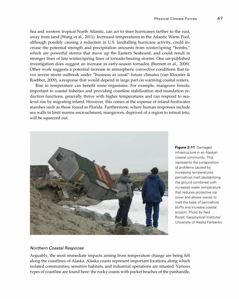
physical Climate Forces 47
Sea and western tropical North Atlantic, can act to steer hurricanes farther to the east, away from land (Wang et al., 2011). Increased temperatures in the Atlantic Warm Pool, although possibly causing a reduction in U.S. landfalling hurricane activity, could in-crease the potential strength and precipitation amounts from winter/spring “bombs,” which are powerful storms that move up the Eastern Seaboard, and could result in stronger lines of late winter/spring lines of tornado-bearing storms. One un-published investigation does suggest an increase in early-season tornados (Burnett et al., 2008). Other work suggests a potential increase in atmospheric convective conditions that fa-vor severe storm outbreak under “business as usual” future climates (van Klooster & Roebber, 2009), a response that would depend in large part on warming coastal waters.
Rise in temperature can benefit some organisms. For example, mangrove forests, important to coastal fisheries and providing coastline stabilization and inundation re-duction functions, generally thrive with higher temperatures and can respond to sea-level rise by migrating inland. However, this comes at the expense of inland freshwater marshes such as those found in Florida. Furthermore, where human responses include sea walls to limit marine encroachment, mangroves, deprived of a region to retreat into, will be squeezed out.
Northern Coastal Response
Arguably, the most immediate impacts arising from temperature change are being felt along the coastlines of Alaska. Alaska coasts represent important locations along which isolated communities, sensitive habitats, and industrial operations are situated. Various types of coastline are found here: the rocky coasts with pocket beaches of the panhandle,
Figure 2-11 Damaged infrastructure in an Alaskan coastal community. This represents the juxtaposition of problems caused by increasing temperatures: permafrost melt destabilizing the ground combined with increased water temperature that reduces protective ice cover and allows waves to melt the base of permafrost bluffs and increase coastal erosion. Photo by Ned Rozell, Geophysical Institute/University of Alaska Fairbanks.

48 CoAsTAl ImpACTs, AdApTATIon, And VUlnerAbIlITIes
South Coast, and Aleutians; eroding bluffs along the West and North Coasts; wide, flat deltas in many areas; and barrier island chains. A key distinction of the Alaska coasts is the presence of ice, both in the ground as permafrost and on the ocean as sea ice. This is unique among U.S. coastal systems.
Accordingly, the primary driver of environmental change in Alaska is temperature. Ice makes northern regions particularly susceptible to temperature change; for example, an increase of two degrees Celsius could take a system from frozen to unfrozen with extensive implications. This is not the case for coastal regimes anywhere else in the U.S. and represents a major additional stressor in addition to sea-level rise, waves, and storm surge.
Earlier work (Serreze et al., 2000; Polyakov et al., 2003) established a 20th century temperature increase in the Alaska region, and recent work by various authors (Lopez-de-Lacalle, 2011; Shulski, 2010; Wendler & Shulski, 2009; Wendler et al., 2010) has rein-forced these findings. The second U.S. National Assessment (Karl et al., 2009) concluded that the Alaska region has warmed at twice the rate of the lower 48; over the last 50 years, mean annual air temperature in Alaska has increased by 3.4°C. Winter and Spring have experienced the largest increases in air temperature: approximately 6.3°C in the last 50 years, which is almost twice the rate of the average annual increase.
Increasing temperature affects ice-dominated systems in Alaska, including glaciers, sea ice, snow cover, and permafrost. Arendt et al. (2009) considered regional impacts on Alaska glaciers; most are losing mass due largely to summer temperature increase that is more apparent at higher elevations. In other words, the freezing line is higher up on the mountains, which causes greater melt at lower elevations.
Another important measure of change for Alaska is ground temperature and snow cover. When frozen, permafrost is stable and strong. When thawed, it can have the con-sistency of thick soup and retains virtually no strength; it can also cause a lowering of the land surface. Weakened coastal sediments are much more susceptible to erosion, and a lower land surface is more susceptible to inundation by storm surge. Changes in snow cover can affect ground temperatures and sea-ice formation. One implication of weakened permafrost surfaces and changes to snow cover are impacts on tundra travel.
Atkinson (2005) indicated a general increase in circum-Arctic coastal-storm activity generated largely due to a major atmospheric circulation shift that occurred in the mid-1970s. A reduced sea-ice cover will result in increased potential for storm damage due to surge and erosion, which is further detailed below. Storms also exert an impact on temperature via advection; that is, their strong winds can move warm or cold air over a region. A particularly strong coastal storm in 2000 caused widespread decreases in ground temperatures in the North Slope region (Atkinson & Hinzman, 2008).
Coastal impacts, including erosion and damage to infrastructure, are strongly de-pendent upon coastal sea ice, which can both amplify or mitigate damage depending on the processes at work. Ice driven onshore by winds or currents can bulldoze shore sedi-ments or damage structures (Christensen, 1994). Shore-fast ice frozen onto structures can cause considerable damage during surges or break-out events (Atkinson et al., 2011). Also, by entraining sea-floor sediments, sea ice is a highly effective erosion and trans-port agent (Are et al., 2008). Recent reductions in Arctic sea-ice extent and thickness may result in substantial increases in the amount of material removed from the coastal zone
physical Climate Forces 49
by sea ice (Eicken et al., 2005). Such ice-mediated export of nearshore sediments also plays a role in enhancing the impacts of wave action that drives erosion and thawing of coastal permafrost, amplified by recent changes in the length of the open water season (Overeem et al., 2011). At the same time, formation of nearshore ice well in advance of the appearance of the ice pack can provide protection to the coastline through the forma-tion of ice berms in the surf zone (Atkinson, 2011). The complicated interplay between these different factors that serve to amplify or dampen the effects of climate change on ice action in the nearshore zone is at present not well understood. For the entire Arctic region, sea-ice area and thickness are decreasing, with summer ice-extent reductions on the order of 12 percent per decade for the past three decades (Stroeve et al., 2011). At present, projections from climate models suggest that the Arctic Ocean may be ice-free during summer by about 2040 (Wang & Overland, 2009). However, even a substantially reduced summer ice cover will have major implications for all the processes discussed above.
An important feature of northern ecosystems is their capacity to store large quanti-ties of methane and carbon dioxide in the frozen ground of the tundra, boreal forest, and near-coastal regions. Methane emission in the Arctic is dependent, in part, on the changes in area of wetland and lakes in the North Slope of Alaska during the snow-free season. Ground thaw due to climate warming will increase the formation of thaw-in-duced wetlands, enhancing release of greenhouse gases, which will exacerbate existing global warming trends. Current Arctic contributions to global methane emissions are small, however recent increasing trends have been noted (Bloom et al., 2010). Methane emission had been thought to be a warm-season phenomenon in the Arctic because at-mospheric methane is unusually oxidized in the soil during winter season; however, re-cent field measurements indicate that tussock tundra, which covers more than 6 million square kilometres of the Northern Hemisphere, is an unexpected winter methane source in tundra and boreal forest ecozones (Kim et al., 2007). This indicates winter methane emission should not be overlooked in estimation of regional or global methane budgets. Finally, large reserves of methane are found in nearshore permafrost (Shakhova et al., 2008), which is susceptible to disturbance if coastal temperatures warm; Siberian field data suggests strong methane release in the near-coastal marine region (Shakhova and Semiletov, 2007).
Impact of Climate Change on Coastal Processes
Coastal processes and erosion in Arctic settings differ from coastal processes in sub-arc-tic settings in that both thermal and mechanical processes are important. In the Arctic, coastal sediments are normally locked in place by ice, and thawing of the ice is necessary before mechanical processes such as waves, currents, and wind can transport the sedi-ments. As well, shore fast, bottom fast, and sea ice often protect the coastal zone from wave action. For example, coastal villages on the Chukchi Sea such as Shishmarev and Kivalina were historically protected from the brunt of large late-fall storms due to the presence of nearshore and sea ice, but these villages have been subject in the last decade to the full brunt of these storm waves and surge flooding due to diminished sea-ice cov-erage in the late fall.
Two process sequences are responsible for much of the coastal erosion in Arctic

50 CoAsTAl ImpACTs, AdApTATIon, And VUlnerAbIlITIes
Alaska: (1) niche erosion followed by block collapse and (2) thaw slumping. The term “niche erosion” refers to the cutting of a niche at the base of the coastal bluff. Niche ero-sion/block collapse is a four-process sequence (Figure 2-12).
Storms raise water levels and allow the sea to directly contact the base of the bluff. Waves and currents thermally and mechanically erode a niche at the base of the bluff. The niche grows until the overburden exceeds the bluff strength and block collapse re-sults. The fallen block is then eroded thermally and mechanically by waves and cur-rents. Niche erosion/block collapse is the dominant erosion mechanism in locations dominated by coastal bluffs. Beach survey measurements (Jones et al., 2009a, b; Mars & Houseknecht, 2007) and modeling (Ravens et al., 2012) have documented the rapid and accelerating coastal retreat in locations where this erosion sequence is dominant. Ra-vens et al. (2012) indicate that the main driver in the acceleration of erosion is increasing nearshore water temperature, which weakens the permafrost sediments. Recent obser-vations have shown significant erosion even in the absence of storms.
Thaw slumping is predominant in coastal bluffs with significant coarse material. The term “thaw slumping” refers to the slumping or sloughing of the bluff face following thaw due to radiation or convective heating. Bluff thaw slumping is the predominant erosion mechanism in locations with significant coarse material such as Barter Island in the Beaufort Sea. Bluff erosion in these areas leaves a significant lag deposit that height-ens the beach before the bluff and reduces the frequency of niche erosion.
Three main aspects of climate change in Arctic Alaska directly affect coastal erosion: 1) increased temporal and spatial extent of open water and reduced sea ice concentra-tions, 2) increased water temperatures, and 3) increased air temperatures. The niche ero-sion/block collapse sequence will accelerate due to factors 1, 2, and 3. Increased water temperature, increased wave height due to more open water, and increased temporal extent of open water (factors 1 and 2) will intensify and prolong the niche erosion pro-cess. Also, these process changes along with increasing air temperatures (factor 3) will accelerate the erosion of fallen blocks. Hence, continued increasing erosion rates due to
Figure 2-12 Conceptual model of the processes responsible for niche-erosion/block-collapse in Arctic Alaska. Source: Ravens et al., 2012.
physical Climate Forces 51
niche erosion/block collapse are expected. Thaw slumping will also accelerate due to warming of the atmosphere (factor 3), but this process would not be directly changed by oceanic changes.
A final Arctic coastal process that appears to be affected by climate change is the migration of barrier islands in the Alaska Beaufort Sea in the Arctic Ocean. In the past, these barrier islands have been observed to migrate westward due to the predominant eastern winds and waves. Ravens and Lee (2007) provide evidence that the western end of one of these islands, Narwhal Island, is migrating at an accelerating rate. According to GIS analysis and GPS surveys, between 1955 and 1990, the western end of the island moved at about 5 meters/year. However, in the last two decades between 1990 and 2007, it has moved at 25 meters/year on average.
The recently published IPCC Special Report on Managing the Risks of Extreme Events and Disasters to Advance Climate Change Adaptation “Report for Policy Mak-ers” (IPCC, 2012) indicates that temperature increases and increased variability, includ-ing greater potential for extremes, will continue to be strong for coastal regions. This IPCC result is based on an average of results from a series of climate projection models operated by different research groups and represents the benchmark for assessing what is likely to occur with continued climate warming.
52
Chapter 3
Vulnerability and Impacts on natural resources
Key Findings
f Multiple stressors interact at the coast, which directly impacts natural resources. The responses of natural coastal systems to climate change are complex and subject to nonlinear changes and tipping points. Many of these responses are heavily influenced by the way they are linked with human systems. High Confidence.
f Wetland ecosystems are vulnerable to relative rise in water levels and projected increases in storm activity in zones of significant human use. High Confidence.
f Mangrove range will expand as minimum temperatures increase. High Confidence.
f Coastal forests will tend to migrate upslope and poleward where they are able to keep pace with changing habitat conditions. High Confidence.
f The structure and functioning of estuary and coastal lagoon systems will change with alterations in habitat suitability and the timing of long-standing processes. High Confidence.
f Dynamic barrier island landscapes naturally migrate in response to storm activity and sea-level rise. This process will be confounded by human altera-tions. High Confidence.
f Because of altered sediment supplies and local subsidence, deltas, and the biodiversity they support, are at risk to drowning during rising sea levels. High Confidence.
f Mudflats are susceptible to threshold changes caused by the combined effects of sea-level rise, temperature, land use, altered flows, and increased nutrient runoff. High Confidence.
f Complex interactions between physical and biological factors, which make responses to climate change difficult to predict, have been demonstrated in rocky shore communities. High Confidence.
f Sea ice ecosystems are already being adversely affected by the loss of summer sea ice. Further changes are expected. High Confidence.

Vulnerability and Impacts on natural resources 53
3.1 Multiple Stressors Interact at the Coast
Climate change-mediated impacts originating from terrestrial and marine sources in-teract at the coast to influence coastal habitats (Nicholls et al., 2007; Rosenzweig et al., 2007; Figure 3-1; Table 3-1). On the landward side, increased temperatures and altered precipitation patterns interact with changing land-use and land-cover practices to affect soil moisture, ground water levels, hydrology, sediment supply, salinity, and pollution in watersheds. On the marine side, sea-level rise, changing ocean currents, increased wave heights, and intensification of coastal storms interact with changes in land use and land cover to exacerbate coastal erosion, flooding, and saltwater intrusion. As a result of these interactions, complex changes in coastal freshwater availability and water quality are also occurring.
Coastal Freshwater Availability Threatened by Multi-stressor Interactions
Climatic changes to atmospheric conditions and sea-level rise interact to affect the availability of fresh surface water in coastal regions. Cloern et al. (2011) used a series of linked models under two GCM scenarios to infer the impact of climatic changes on water and habitat quality in the California San Francisco Bay-Delta estuary where water is extracted for human use. Earlier and more extreme spring streamflow combined with reduced flows in the low-flow season as well as sea-level rise led to increased Delta sa-linity (Figure 3-2). These changes have important implications for decisions regarding water releases, which will need to balance drinking and irrigation water quality with support for native fisheries that rely on specific water temperature and salinity ranges and flushing regimes.
Figure 3-1 Major physical climate forces that affect coastal regions either directly or indirectly through external marine and terrestrial influences. Source: Nicholls et al., 2007.
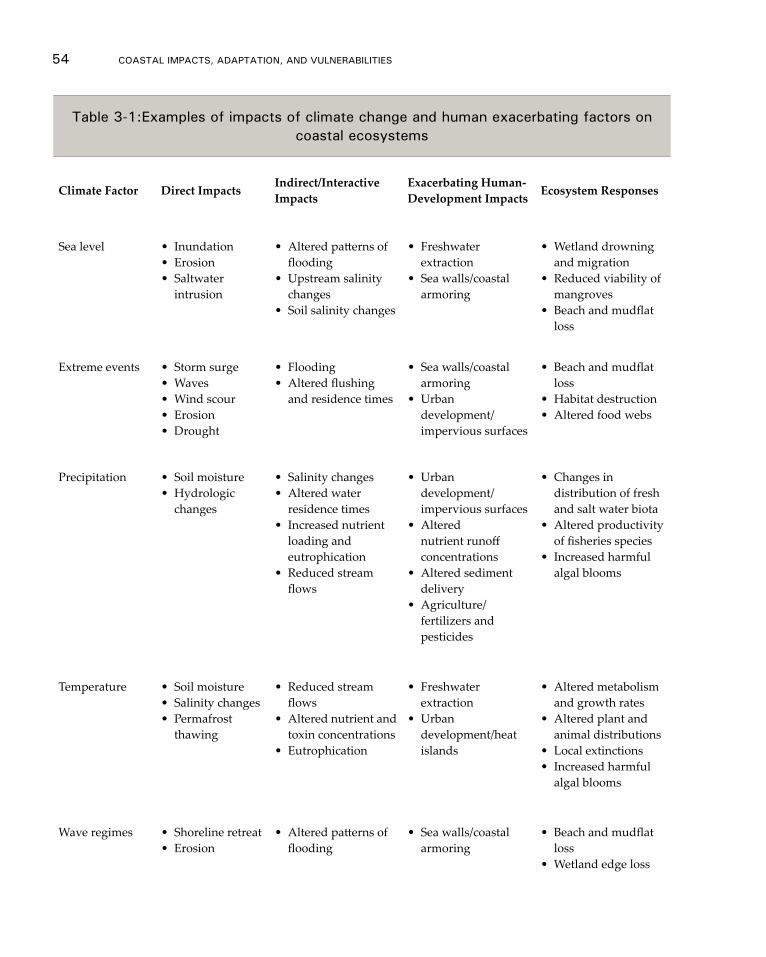
54 CoAsTAl ImpACTs, AdApTATIon, And VUlnerAbIlITIes
Table 3-1:examples of impacts of climate change and human exacerbating factors on coastal ecosystems
Climate Factor Direct Impacts Indirect/Interactive Impacts
Exacerbating Human-Development Impacts Ecosystem Responses
Sea level • Inundation• Erosion• Saltwater
intrusion
• Altered patterns of flooding
• Upstream salinity changes
• Soil salinity changes
• Freshwater extraction
• Sea walls/coastal armoring
• Wetland drowning and migration
• Reduced viability of mangroves
• Beach and mudflat loss
Extreme events • Storm surge• Waves• Wind scour• Erosion• Drought
• Flooding• Altered flushing
and residence times
• Sea walls/coastal armoring
• Urban development/ impervious surfaces
• Beach and mudflat loss
• Habitat destruction• Altered food webs
Precipitation • Soil moisture• Hydrologic
changes
• Salinity changes• Altered water
residence times• Increased nutrient
loading and eutrophication
• Reduced stream flows
• Urban development/ impervious surfaces
• Altered nutrient runoff concentrations
• Altered sediment delivery
• Agriculture/fertilizers and pesticides
• Changes in distribution of fresh and salt water biota
• Altered productivity of fisheries species
• Increased harmful algal blooms
Temperature • Soil moisture• Salinity changes• Permafrost
thawing
• Reduced stream flows
• Altered nutrient and toxin concentrations
• Eutrophication
• Freshwater extraction
• Urban development/heat islands
• Altered metabolism and growth rates
• Altered plant and animal distributions
• Local extinctions• Increased harmful
algal blooms
Wave regimes • Shoreline retreat• Erosion
• Altered patterns of flooding
• Sea walls/coastal armoring
• Beach and mudflat loss
• Wetland edge loss
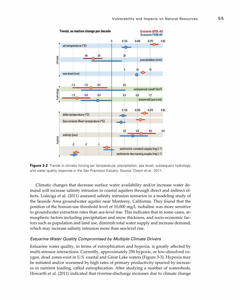
Vulnerability and Impacts on natural resources 55
Climatic changes that decrease surface water availability and/or increase water de-mand will increase salinity intrusion in coastal aquifers through direct and indirect ef-fects. Loáiciga et al. (2011) assessed salinity intrusion scenarios in a modeling study of the Seaside Area groundwater aquifer near Monterey, California. They found that the position of the human-use threshold level of 10,000 mg/L isohaline was more sensitive to groundwater extraction rates than sea-level rise. This indicates that in some cases, at-mospheric factors including precipitation and snow thickness, and socio-economic fac-tors such as population and land use, diminish total water supply and increase demand, which may increase salinity intrusion more than sea-level rise.
Estuarine Water Quality Compromised by Multiple Climate Drivers
Estuarine water quality, in terms of eutrophication and hypoxia, is greatly affected by multi-stressor interactions. Currently, approximately 250 hypoxic, or low-dissolved ox-ygen, dead zones exist in U.S. coastal and Great Lake waters (Figure 3-3). Hypoxia may be initiated and/or worsened by high rates of primary productivity spurred by increas-es in nutrient loading, called eutrophication. After studying a number of watersheds, Howarth et al. (2011) indicated that riverine-discharge increases due to climate change
Figure 3-2 Trends in climatic forcing (air temperature, precipitation, sea level), subsequent hydrology, and water quality response in the San Francisco Estuary. Source: Cloern et al., 2011.

56 CoAsTAl ImpACTs, AdApTATIon, And VUlnerAbIlITIes
will increase net anthropogenic nitrogen inputs to coastal waters, thereby increasing eu-trophication and hypoxia. Climate change, especially warming, may also make systems more susceptible to development of hypoxia through enhanced water column stratifi-cation, decreased solubility of oxygen, and increased metabolism and mineralization rates. High-precipitation storms, which are on the increase (see Chapter 2 section 7 this report), increase stratification and organic matter flushed into estuarine and coastal sys-tems from the watershed; algal blooms can result from the nutrient pulses they inject into estuarine and coastal ecosystems (Paerl et al., 2006a) and massive hypoxia can be triggered by such events (Justic et al., 2007; Paerl et al., 2006b). For the Mississippi River basin associated with the northern Gulf of Mexico seasonal dead zone, climate predic-tions suggest a 20 percent increase in river discharge (Miller & Russell, 1992) that would lead to elevated nutrient loading, a 50 percent increase in primary production, and ex-pansion of the oxygen-depleted area (Justic et al., 1996). All factors related to climate change will progressively lead to an onset of hypoxia earlier in the season and longer periods of hypoxia over time (Boesch et al., 2007)
Figure 3-3 Overall eutrophic condition of the nation’s estuaries and change. Source: Bricker et al., 2007.

Vulnerability and Impacts on natural resources 57
3.2 Biota, habitats, and Coastal Landforms that are Impacted by Complex Stressor Interactions and Subject to nonlinear Changes and Tipping Points
Coastlines are dynamic systems subject to complex interactions of climate and non-cli-mate stressors. When multiple stressors act in combination on an ecosystem, nonlinear instabilities may be triggered (Burkett et al., 2005; CCSP, 2009a; Nicholls et al., 2007). Such nonlinear responses can be amplified and accelerated by synergies and positive feedbacks that increase the alteration of the system and cause a domino-like propaga-tion of potentially-irreversible change. Synergies and feedbacks occur when the impact of one stressor is either strengthened or weakened by variation in another, and the com-bined influence of multiple stressors can result in nonlinear ecological changes if popu-lations or ecosystems are pushed beyond a critical threshold or tipping point (Harley et al., 2006; Lubchenco & Petes, 2010). In some cases, threshold shifts can be caused by gradual climate change if that change is occurring at a rate beyond which the ecosystem can adapt (McNeall et al., 2011). A threshold is defined as “the point at which there is an abrupt change in an ecosystem quality, property or phenomenon, or where small changes in one or more external conditions produce large and persistent responses in an ecosystem” (CCSP, 2009b: pg. vii).
Multi-stressor interactions and resulting nonlinear changes in ecosystems, which can manifest over varying spatial and temporal scales, add further complexity (Groffman et al., 2006). Research on identifying and predicting thresholds in ecosystems is still na-scent but is growing rapidly (Groffman et al., 2006; Scheffer et al., 2009). Both theoretical and empirically-based examples of thresholds are on the rise and signal an increasing understanding of how climate and non-climate stressors interact to propel sudden shifts in ecosystems.
Wetlands: These ecosystems are vulnerable to relative rise in water levels togeth-er with projected increase in storm activity in zones of significant human use.
Salt marshes have considerable capacity to adjust to sea-level rise under favorable con-ditions of hydrology and sediment supply (Cahoon et al., 2009). Wetlands build soil by a combination of trapping fine-grained cohesive mineral sediments carried by tidal waters and accumulation of plant matter generated onsite. Fine-grained sediment bud-gets are often poorly understood (Cahoon el al., 2009). The supply of mineral sediments can vary widely from high loads in deltaic and back-barrier systems to minimal inputs in extensive estuarine marshes.Increasing inundation can lead to higher rates of sedi-ment deposition (Marion et al., 2009), sediment trapping, and organic matter accretion (Morris et al., 2002). However, the ability of these ecogeomorphic feedbacks to preserve salt marshes under climate change is limited. Based on simulations from five numerical models, Kirwan et al. (2010) concluded that coastal marshes would likely survive con-servative projections of sea-level rise but would be vulnerable under scenarios of rapid sea-level rise linked to ice sheet melting.
The regional and sub-regional marshes in North America differ significantly in their ability to build elevation. Northeastern U.S. marshes exhibit high rates of accretion, while southeastern Atlantic, Gulf of Mexico, and Pacific salt marshes exhibit lower rates
58 CoAsTAl ImpACTs, AdApTATIon, And VUlnerAbIlITIes
(Cahoon et al., 2006). Even within a single estuary, tidal marshes can be more or less susceptible to sea-level rise depending on local sediment availability (Stralberg et al., 2011). Marshes with low accretion rates are vulnerable to present and future sea-level rise, with the exception of those in areas where the land surface is rising, such as on the Pacific Northwest coast of the U.S.
The natural supply of mineral sediments contributing to wetland accretion can be significantly altered by human activities. The interruption of sediment supply to wet-lands caused by diking along the Mississippi River is the classic example. Organic matter deposition can be significant in highly productive wetland systems, but decom-position processes moderate the relative importance of this source. Chemical compo-nents in saltwater increase the rate that organic matter decomposes and thus reduce the contribution of organic sediments to soil-building processes in salt marshes compared to freshwater systems. Disturbance to vegetation on an otherwise stable marsh could also lead to submergence beyond depths capable of supporting emergent vegetation, with a consequent shift to an alternative state such as subtidal open water (Kirwan et al., 2008; Marani et al., 2007). Recent vulnerability assessments carried out for the San Francisco Bay and Massachusetts Bays regions (EPA, 2012a, b) supplement these findings. Local experts identified the potential for wetlands to drop below a threshold for sustainability by mid-century in both locations. In California, this could be caused by the effects of sea-level rise in combination with increased wind-driven waves and sediment starvation. In Massachusetts, wetland loss could result from changes in hydrology and land use along with increased nutrient runoff.
Mangroves: Mangrove range will expand as minimum temperatures increase.
Mangroves in the southern U.S. have been affected by lapses in freeze events and ex-treme drought events in recent decades. These represent a threshold change in climate pattern that may account for unprecedented mangrove expansion into subtropical salt-marsh and freshwater ecosystems along the northern Gulf of Mexico. Mangrove popu-lations have long persisted along the coasts of Texas, Louisiana, and Florida but are undergoing more recent expansion in latitudes above the tropical Everglades region (Doyle et al., 2010; Michot et al., 2010). An abrupt increase in establishment of black mangrove, Avicennia germinans, was observed in 2009 based on aerial surveys begun less than a decade earlier, with ground studies showing increased area and density of local populations since the last damaging freeze two decades ago (Michot et al., 2010). As the periodicity of freeze events lengthens, mangrove expansion is expected to pro-ceed landward and poleward along the northern Gulf Coast, changing the proportion of saltmarsh area. Recent field and mapping studies in the northern Everglades have docu-mented upslope migration of mangroves into tidal freshwater wetlands over the last century, concomitant with historical rates of sea-level rise (Doyle et al., 2010; Krauss et al., 2011). Landscape simulation models have been used to reconstruct historical migra-tion and forecast expansion of mangrove systems in relation to tropical storms and sea-level rise along with decreased freeze events and increased drought frequencies under climate change (Doyle & Girod 1997; Doyle et al., 2003, 2010).
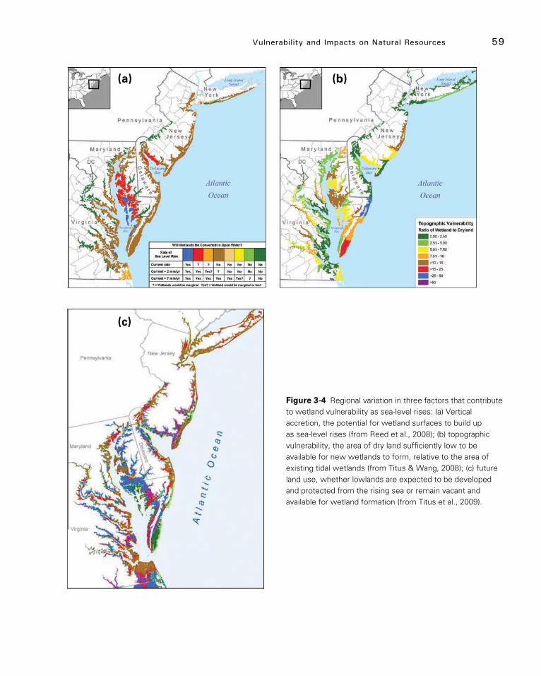
Vulnerability and Impacts on natural resources 59
Figure 3-4 Regional variation in three factors that contribute to wetland vulnerability as sea-level rises: (a) Vertical accretion, the potential for wetland surfaces to build up as sea-level rises (from Reed et al., 2008); (b) topographic vulnerability, the area of dry land sufficiently low to be available for new wetlands to form, relative to the area of existing tidal wetlands (from Titus & Wang, 2008); (c) future land use, whether lowlands are expected to be developed and protected from the rising sea or remain vacant and available for wetland formation (from Titus et al., 2009).
(a) (b)
(c)
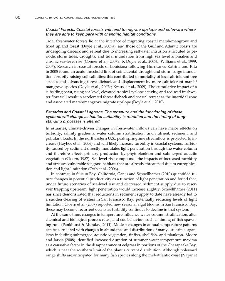
60 CoAsTAl ImpACTs, AdApTATIon, And VUlnerAbIlITIes
Coastal Forests: Coastal forests will tend to migrate upslope and poleward where they are able to keep pace with changing habitat conditions.
Tidal freshwater forests lie at the interface of migrating coastal marsh/mangrove and fixed upland forest (Doyle et al., 2007a), and those of the Gulf and Atlantic coasts are undergoing dieback and retreat due to increasing saltwater intrusion attributed to pe-riodic storm tides, droughts, and tidal inundation from high sea level anomalies and chronic sea-level rise (Conner et al., 2007a, b; Doyle et al., 2007b; Williams et al., 1999, 2007). Research in coastal forests of Louisiana following Hurricanes Katrina and Rita in 2005 found an acute threshold link of coincidental drought and storm surge inunda-tion abruptly raising soil salinities; this contributed to mortality of less salt-tolerant tree species and advancing forest dieback and displacement by more salt-tolerant marsh/mangrove species (Doyle et al., 2007c; Krauss et al., 2009). The cumulative impact of a subsiding coast, rising sea level, elevated tropical cyclone activity, and reduced freshwa-ter flow will result in accelerated forest dieback and coastal retreat as the intertidal zone and associated marsh/mangrove migrate upslope (Doyle et al., 2010).
Estuaries and Coastal Lagoons: The structure and the functioning of these systems will change as habitat suitability is modified and the timing of long-standing processes is altered.
In estuaries, climate-driven changes in freshwater inflows can have major effects on turbidity, salinity gradients, water column stratification, and nutrient, sediment, and pollutant loads. In the northeastern U.S., peak springtime streamflow is projected to in-crease (Hayhoe et al., 2006) and will likely increase turbidity in coastal systems. Turbid-ity caused by sediment directly modulates light penetration through the water column and therefore affects primary production by phytoplankton and submerged aquatic vegetation (Cloern, 1987). Sea-level rise compounds the impacts of increased turbidity and stresses vulnerable seagrass habitats that are already threatened due to eutrophica-tion and light-limitation (Orth et al., 2006).
In contrast, in Suisun Bay, California, Ganju and Schoellhamer (2010) quantified fu-ture changes in potential productivity as a function of light penetration and found that, under future scenarios of sea-level rise and decreased sediment supply due to reser-voir trapping upstream, light penetration would increase slightly. Schoellhamer (2011) has since demonstrated that reductions in sediment supply to date have already led to a sudden clearing of waters in San Francisco Bay, potentially reducing levels of light limitation. Cloern et al. (2007) reported new seasonal algal blooms in San Francisco Bay; these may become recurrent events as turbidity continues to decline in that system.
At the same time, changes in temperature influence water-column stratification, alter chemical and biological process rates, and cue behaviors such as timing of fish spawn-ing runs (Pankhurst & Munday, 2011). Modest changes in annual temperature patterns can be correlated with changes in abundance and distribution of many estuarine organ-isms including submerged aquatic vegetation, finfish, shellfish, and plankton. Moore and Jarvis (2008) identified increased duration of summer water temperature maxima as a causative factor in the disappearance of eelgrass in portions of the Chesapeake Bay, which is near the southern limit of the plant’s current distribution. Although poleward range shifts are anticipated for many fish species along the mid-Atlantic coast (Najjar et
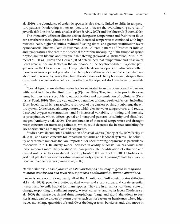
Vulnerability and Impacts on natural resources 61
al., 2010), the abundance of endemic species is also clearly linked to shifts in tempera-ture patterns. Moderating winter temperatures increase the overwintering survival of juvenile fish like the Atlantic croaker (Hare & Able, 2007) and the blue crab (Bauer, 2006).
The interactive effects of climate-driven changes in temperature and freshwater flows can reverberate throughout the food web. Increased temperatures combined with high nutrient loads, higher salinities, reduced flushing times, and greater stratification favor cyanobacterial blooms (Paerl & Huisman, 2008). Altered patterns of freshwater inflows and temperatures also create the potential for trophic uncoupling of the timing of spring phytoplankton blooms and juvenile fish hatching (Edwards & Richardson, 2004; Kim-mel et al., 2006). Purcell and Decker (2005) determined that temperature and freshwater flows were important factors in the abundance of the scyphomedusan Chrysaora quin-quecirrha in the Chesapeake Bay. This jellyfish feeds on copepods but also eats another, more voracious copepod predator, the ctenophore Mnemiopsis leidyi. When jellyfish are abundant in warm dry years, they limit the abundance of ctenophores and, despite their own predation, generate a net positive effect on the copepod stock available for juvenile fish.
Coastal lagoons are shallow water bodies separated from the open ocean by barriers with restricted inlets that limit flushing (Kjerfve, 1994). They tend to be productive sys-tems, but they are susceptible to eutrophication and accumulation of pollutants (Ken-nish & Paerl, 2010). They are vulnerable to a number of climate-related factors, including 1) sea-level rise, which can accelerate roll-over of the barriers or simply submerge the en-tire system, 2) increased air temperatures, which elevate water temperatures and reduce dissolved oxygen concentrations, and 3) increased variability in timing and intensity of precipitation, which affects spatial and temporal patterns of salinity and dissolved oxygen (Anthony et al., 2009). The combination of increased temperature and drought raises concerns for increasing salinities, which could decrease the habitat suitability for key species such as mangroves and seagrasses.
Studies have documented acidification of coastal waters (Doney et al., 2009; Feeley et al., 2009) and raised concerns for impacts in estuarine and lagoonal systems. The solubil-ity of carbonate minerals that are important for shell-forming organisms is particularly responsive to pH. Relatively minor increases in acidity of coastal waters could make those minerals more likely to dissolve than precipitate. Acidification of estuarine and coastal waters can be exacerbated by eutrophication (Howarth et al., 2011). Studies sug-gest that pH declines in some estuaries are already capable of causing “death by dissolu-tion” in juvenile bivalves (Green et al., 2009).
Barrier Islands: These dynamic coastal landscapes naturally migrate in response to storm activity and sea-level rise, a process confounded by human alterations.
Barrier islands occur along nearly all of the Atlantic and Gulf coastal plains (FitzGer-ald et al., 2008), provide a buffer against waves and storm surge, and create essential nursery and juvenile habitat for many species. They are in an almost continual state of change, responding to sediment supply, waves, currents, and water levels (Gutierrez et al., 2009) that shape beach and dune morphology. Large and rapid alterations to bar-rier islands can be driven by storm events such as nor’easters or hurricanes where high waves move large quantities of sand. Over the longer term, barrier islands also move in

62 CoAsTAl ImpACTs, AdApTATIon, And VUlnerAbIlITIes
response to changes in sea level by migrating landward and conserving mass through onshore sediment transport.
As the effects of storm events and sea-level rise intensify under climate change, the response of barrier island systems will depend largely upon sand supply and transport processes (Gutierrez et al., 2009). Human development in the form of coastal construc-tion and shoreline engineering structures such as seawalls and jetties have significantly altered sediment-transport processes in some locations, exacerbating erosion at local sites and compromising the sustainability of beaches and barriers. For example, the ex-tensive barrier system along the North Carolina coast is dependent on storm surges and waves for movement of the large quantities of sand critical for building and maintain-ing island elevation and width (FitzGerald et al., 2008; Riggs et al., 2011). Hardening of shorelines to protect roads, residential development, and other infrastructure has al-ready resulted in reduced sand supply and compromised the capacity of the natural barrier island system to adapt to sea-level rise.
Considerable evidence suggests that the abovementioned effects of human develop-ment in combination with sea-level rise and storm-driven waves can lead to the cross-ing of a geomorphic threshold and consequent irreversible changes to coastal barriers that can no longer keep pace with environmental changes (Gutierrez et al., 2009). These changes may include rapid landward migration; decreased barrier width and height; barrier breaching and inlet formation; and barrier segmentation and disintegration. Examples of observed or projected threshold crossings for barrier islands have been documented in Louisiana (FitzGerald et al., 2008; Sallenger et al., 2007) and Maryland (Morton et al., 2003; Gutierrez et al., 2009). The potential for threshold behavior will in-crease along many of the mid-Atlantic barrier islands under scenarios of future climate change (Gutierrez et al., 2009).
Deltas: Because of altered sediment supplies and local subsidence, deltas, and the biodiversity they support, are at risk to drowning during rising sea levels.
Coastal deltas are formed where rivers empty into the ocean and deposit sediments, building a shallow, nutrient-rich platform and providing a fertile environment for di-verse populations of marine organisms. The morphology is determined by a combina-tion of physical processes driven by the river, waves, and tides (Bird, 2011). A changing climate, particularly rises in sea level, and the impacts of human development along riv-ers and coasts are now playing a significant role in the behavior and evolution of delta regions.
In a changing climate, deltaic environments will experience impacts similar to those in estuaries, mangrove forests, and wetlands (Table 1). Changes in temperature and pre-cipitation will affect water quality and ultimately, the viability of delta-supported biota and fisheries (Overeem & Syvitski, 2009). For example, in the San Francisco Bay-Delta system, increasing water temperatures threaten the sustainability of two endangered species: 1) deltaic smelt due to mean daily temperature threshold of 25°C for high adult mortality and 2) Chinook salmon due to spawning and rearing temperature exceed-ances (Cloern et al., 2011; Yates et al., 2008). Habitat and water quality are also impacted by altered patterns of precipitation, which affect deltaic hydrology and the input of sedi-ments and pollutants.
Vulnerability and Impacts on natural resources 63
Delta survival requires equilibrium between sediment supply and rising sea levels. Deltas naturally degrade as sediments subside and get reworked by storms, and, over the longer term, deltas, like barrier islands, are generally self-sustaining systems un-der natural conditions given an adequate supply of sediment. However, the construc-tion of levees and dams, and navigation activities along major U.S. rivers have altered natural sediment flows and, in some cases, starved the natural environment of the sedi-ment supply necessary to keep pace with changing water levels. Deltas world-wide are experiencing land-loss due to the combined effects of increased human development, subsidence, and rising sea levels (Nicholls et al., 2007; Syvitski et al., 2009). The Bird’s-Foot Delta of the Mississippi River provides one of the more striking examples of these compounding impacts. Here, sea levels are rising at three times the rate of sediment accumulation on the delta, which portends the inevitable drowning of this delta system (Blum & Roberts, 2009).
Mudflats: Mudflats are susceptible to threshold changes due to the combined effects of sea-level rise, temperature, land use, altered flows, and increased nutrient runoff.
Sea-level rise is already reducing the intertidal area of mudflat feeding habitat for wading birds within estuaries, especially in locations constrained by coastal protective barriers (Galbraith et al., 2005). In a recent assessment of the sensitivities of mudflat communities to climate change in the San Francisco Bay estuary (EPA, 2012a), local experts identified the potential for nonlinear losses within benthic communities due to a combination of nutrient runoff and increased temperatures that drive dissolved oxygen levels below a threshold. They also anticipated precipitous losses of wading bird populations due to reduced prey densities and shrinking feeding habitat resulting from sea-level rise and sediment starvation. Although the potential for such thresholds may be high, patterns of disturbance and recovery in mudflats are extremely patchy and context-dependent and larger-scale behavioral responses of bird populations are unknown, which makes predictions of exactly when and where a threshold change may occur difficult to offer (EPA, 2012a; Norkko et al., 2010).
Rocky Shores: Complex interactions between physical and biological factors have been demonstrated in rocky-shore communities, which makes responses to climate change difficult to predict.
Although the impacts of sea-level rise are obvious for rocky-shore intertidal communi-ties, temperature and ocean acidity are also potentially important. Hawkins et al. (2008) have noted general changes in abundance and range of rocky-shore species that can be attributed to climate warming. Although most of these changes involve range expan-sions, investigators caution that this may simply reflect the preponderance of studies at the northern limits of species ranges compared to studies in lower latitudes. At a region-al scale, long-term recruitment records for mussels and barnacles showed a relationship to large-scale climate and upwelling patterns along the U.S. West Coast (Menge et al., 2011a). The relationship explained approximately 40 percent of the variance in the re-cruitment record. At the local scale, Harley (2011) determined that climate warming had the potential to drive changes in the community structure of rocky shores as it limited
64 CoAsTAl ImpACTs, AdApTATIon, And VUlnerAbIlITIes
habitat suitability in the high intertidal zone for barnacles and mussels. Temperature tolerances could force these keystone species to live in lower, cooler zones where they are more vulnerable to predatory sea stars.
Increasing ocean acidity may make building and maintaining calcium carbonate shells more difficult, and this may be detrimental to key shellfish species in rocky shore communities (Gaylord et al., 2011). In addition to the loss of structural diversity this might cause, diminished populations of filter feeders and rock-cleaning invertebrates could lead to increased algal populations on rocky shores.
Although these findings suggest rocky intertidal communities are affected by cli-mate, the complexity of key species’ individual and interactive responses to many other environmental drivers make predicting community responses difficult (Menges et al., 2001b).
Sea-ice systems: Sea-ice ecosystems are already being adversely affected by the loss of summer sea ice and further changes are expected.
Perhaps most vulnerable of all to the impacts of warming are Arctic ecosystems such as the Bering Sea. This area off the western coast of Alaska produces our nation’s largest commercial fish harvests as well as providing food for many Native Alaskan peoples. Sea ice, a critical component of this ecosystem, is vanishing more rapidly than earlier projections and may disappear entirely in summertime within this century (ACIA, 2005; Janetos et al., 2008; Royal Society, 2005). Fish populations depend on plankton blooms that are regulated by the extent and location of the ice edge in spring. As sea ice contin-ues to decline, the location, timing, and species composition of the blooms is changing. The spring melt of sea ice in the Bering Sea has long provided material that feeds clams, shrimp, and other life forms on the ocean floor that, in turn, provide food for walruses, gray whales, bearded seals, eider ducks, and many fish; however, the earlier ice melt resulting from warming leads to phytoplankton blooms that are largely consumed by microscopic animals near the sea surface, which vastly decreases the amount of food reaching the living things on the ocean floor. This will radically change the species com-position of the fish and other creatures with significant repercussions for both subsis-tence and commercial fishing (Janetos et al., 2008).
Ringed seals give birth in snow caves on the sea ice, which protect their pups from extreme cold and predators. Warming leads to earlier snow melt, which causes the snow caves to collapse before the pups are weaned. The small, exposed pups may die of hy-pothermia or be vulnerable to predation by arctic foxes, polar bears, gulls, and ravens. Gulls and ravens are also arriving earlier in the Arctic as springs become warmer, which increases the birds’ opportunity to prey on the seal pups (Janetos et al., 2008).
Polar bears are the top predators of the sea-ice ecosystem and they use the ice as a platform from which to hunt seals, their primary prey. Polar bears take advantage of the fact that seals must surface to breathe in limited openings in the ice cover. In the open ocean, successful hunting is rare because bears lack a hunting platform and seals are not restricted in where they can surface. In addition, the rapid rate of warming in Alaska and the rest of the Arctic is sharply reducing the snow cover in which polar bears build dens. Female polar bears hibernate in dens for four to five months each year and, while there, give birth to their cubs. Born weighing only about 1 pound, the tiny cubs depend

Vulnerability and Impacts on natural resources 65
on the snow den for warmth. About two-thirds of the world’s polar bears are projected to be gone by the middle of this century. In 75 years, projections suggest that the wild polar bear population will be gone entirely from Alaska (Janetos et al., 2008).
Conclusions
Threshold shifts in ecosystems can have severe negative consequences for ecosystem services, economic sustainability, and human health and well-being (Harley et al., 2006; Lubchenco & Petes, 2010; MEA, 2005). Recent papers have further advanced the dia-logue on key research directions for elucidating threshold mechanisms and identifying early-warning signals of impending abrupt transitions (Groffman et al., 2006; Scheffer et al., 2009); however, even though single-species responses to particular stressors often are fairly well known, mechanistic understanding of cumulative effects of multi-stressor interactions, especially at the community level, remains elusive. A recent review of top research priorities for conservation and management cites the need to expand scien-tific understanding of multi-stressor interactions and thresholds (Fleishman et al., 2011). This includes methods to identify the triggers of threshold responses and to anticipate the likely trajectory of post-threshold states under a range of future scenarios of climate and land-use change (Briske et al., 2006). Such information will be key to managers’ abil-ity to manage for change when threshold shifts occur (West et al., 2009).
As the natural resources of coastal systems respond to changing climatic conditions, human modification and management of these systems is a major factor in the character of the response. In many cases the capacity of coastal systems to reposition or reshape themselves in response to climate drivers is constrained by the physical modifications made to accommodate and sustain human uses. This adds an additional level of com-plexity to forecasts of ecosystem responses. It also highlights the need for system-level thinking as we work to adapt to the evolving conditions.
66
Chapter 4
Vulnerability and Impacts on human development
Key Findings
f Expanding economic and population exposure along the coast significantly increases the risk of harm and exposes already vulnerable communities to the impacts of climate change. Since 1980, roughly half of the nation’s new residential building permits were issued in coastal counties, which substantially increases vulnerability and risk of loss and adds to already populated and densely devel-oped metropolitan areas. High Confidence.
f The full measure of human vulnerability and risk is comprised of the vulner-abilities of human development, economic sectors, associated livelihoods, and human well-being. The interactions of climate-related vulnerabilities with other stressors in the coastal zone pose analytical challenges when coupled with the lack of quantitative, multi-stressor vulnerability assessments. High Confidence.
f Storm surge flooding and sea-level rise pose significant threats to public and private infrastructure that provides energy, sewage treatment, clean water, and transportation of people and goods. These factors increase threats to public health, safety, and employment in the coastal zone. High Confidence.
f Systematic incorporation of climate risk into the insurance industry’s rate-setting practices and other business investment decisions could present a cost-effective way to deal with low probability, high severity weather events. Without reform, the financial risks associated with both private and public hazard insurance are expected to increase as a result of expected climate change and sea-level rise. High Confidence.
f Expected public health impacts include a decline in seafood quality, shifts in disease patterns and increases in rates of heat-related morbidity. Better predic-tions of coastal related public health risks will require sustained multi-disci-plinary collaboration among researchers and health practitioners in the climate, oceanography, veterinary, and public health sciences. Moderate Confidence.
f Although the Department of Defense (DoD) has started to consider the impacts of climate change on coastal installations, operations, and military readiness, the DoD requires actionable climate information and projections at mission-relevant temporal and spatial scales to maintain effective training, deployment, and force sustainment capabilities. High Confidence.
Vulnerability and Impacts on Human development 67
4.1 overview: Impacts on human development and Societal Vulnerability
The societal vulnerability of U.S. coasts to climate change is multifaceted, including vulnerabilities of economic sectors, cultural resources, and human well-being of a di-verse concentration of people. In addition to the vulnerability and potential impacts of a changing climate on natural resources and threats to ecosystem services described in Chapter 3, homes and other human development in the coastal zone are also increas-ingly at risk. This expanded vulnerability has three dimensions: exposure, sensitivity, and resilience or adaptive capacity. The interactions of climate-related vulnerabilities with other stresses, such as economic downturn, environmental degradation, loss of ecosystem services, and continued pressures for development pose further analytical challenges. Current research on societal vulnerability in the coastal area does not yet fully consider or capture these multifaceted attributes of societal vulnerability.
Rising sea levels will change accretion and erosion patterns and increase tidal and storm-surge flooding in the coastal zone. Weiss and others (2011) report that 160 U.S. municipalities with populations between 50,000 and 300,000 and 20 major cities with populations greater than 300,000 have land areas at or below 6 meters and connectivity to the ocean. Figure 4-1 shows the major cities with populations greater than 300,000 and the percent of land in those cities at elevations between 1 and 6 meters. The figure suggests that the most vulnerable coastal cities in the U.S. are located in the southern area of the Atlantic Ocean and the Gulf of Mexico.
Neumann and others (2010) assessed the consequences of sea-level rise on developed coastal areas of the continental U.S. and determined the cost of adaptation to increased tidal flooding over time. They considered three adaptation options: retreat, beach
Figure 4-1 Land area percentages of major municipalities (2000 census population greater than 300,000) with elevations at or below 1-6 m and connectivity to the sea. The average land area percentage for all 180 municipalities (200 census population greater than 50,000) with elevations at or below 1-6 meters and connectivity to the sea is on the right. Source: Weiss et al., 2011. Used with permission from Climatic Change.
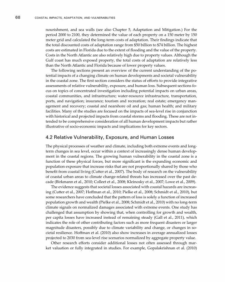
68 CoAsTAl ImpACTs, AdApTATIon, And VUlnerAbIlITIes
nourishment, and sea walls (see also Chapter 5, Adaptation and Mitigation.) For the period 2000 to 2100, they determined the value of each property on a 150 meter by 150 meter grid and calculated the long-term costs of adaptation. Their findings indicate that the total discounted costs of adaptation range from $50 billion to $74 billion. The highest costs are estimated in Florida due to the extent of flooding and the value of the property. Costs in the North Atlantic are also relatively high due to property values. Although the Gulf coast has much exposed property, the total costs of adaptation are relatively less than the North Atlantic and Florida because of lower property values.
The following sections present an overview of the current understanding of the po-tential impacts of a changing climate on human developments and societal vulnerability in the coastal zone. The first section considers the status of efforts to provide integrative assessments of relative vulnerability, exposure, and human loss. Subsequent sections fo-cus on topics of concentrated investigation including potential impacts on urban areas, coastal communities, and infrastructure; water-resource infrastructure, transportation, ports, and navigation; insurance; tourism and recreation; real estate; emergency man-agement and recovery; coastal and nearshore oil and gas; human health; and military facilities. Many of the studies are focused on the impacts of sea-level rise in conjunction with historical and projected impacts from coastal storms and flooding. These are not in-tended to be comprehensive consideration of all human development impacts but rather illustrative of socio-economic impacts and implications for key sectors.
4.2 relative Vulnerability, exposure, and human Losses
The physical processes of weather and climate, including both extreme events and long-term changes in sea level, occur within a context of increasingly dense human develop-ment in the coastal regions. The growing human vulnerability in the coastal zone is a function of these physical forces, but more significant is the expanding economic and population exposure that increase risks that are not proportionally shared by those who benefit from coastal living (Cutter et al., 2007). The body of research on the vulnerability of coastal urban areas to climate change-related threats has increased over the past de-cade (Birkmann et al., 2010; Colleet et al., 2008; Kleinosky et al., 2007; Lowe et al., 2009).
The evidence suggests that societal losses associated with coastal hazards are increas-ing (Cutter et al., 2007; Hoffman et al., 2010; Pielke et al., 2008; Schmidt et al., 2010), but some researchers have concluded that the pattern of loss is solely a function of increased population growth and wealth (Pielke et al., 2008; Schmidt et al., 2010) with no long-term climate signals on normalized damages associated with extreme events. One study has challenged that assumption by showing that, when controlling for growth and wealth, per capita losses have increased instead of remaining steady (Gall et al., 2011), which indicates the role of other contributing factors such as more frequent disasters or larger magnitude disasters, possibly due to climate variability and change, or changes in so-cietal resilience. Hoffman et al. (2010) also show increases in average annualized losses projected to 2030 from sea-level rise scenarios normalized by aggregate property value.
Other research efforts consider additional losses not often assessed through mar-ket valuation or fully integrated in studies. For example, Gopalakrishnan et al. (2010)

Vulnerability and Impacts on Human development 69
evaluated the value of beach width using a hedonic pricing model8 and found that resi-dential property values may decline substantially in places affected by increased ero-sion rates and costs of sand nourishment. The analysis suggests that residential housing values in coastal regions may be sensitive to the availability of sand for maintaining beaches. Chapter 3 of this report discusses some of the impacts on natural resources systems that can also provide ecosystem services that benefit human systems (see also Real Estate and Tax Revenue, section 4.4.5) Public listening sessions conducted in North Carolina in 2010 raised concerns over anticipated community costs of adapting vulner-able infrastructure in response to potential climate change impacts as well as respond-ing to increased job losses in fisheries, reduction of agricultural lands and the farming industry, loss of manufacturing plants along the water, and declines in tourism (Brown et al., 2010). On an individual level, inspirational and tacit values of coastal lagoons, or sense of place, are difficult to value and often overlooked in evaluating impacts (An-thony et al., 2009).
Since the 2009 NCA, considerable advancements have been made towards under-standing the links between environmental stressors and social vulnerability in coast-al areas and developing the empirical basis for assessing differential impacts. Most of the extant research examines a single stressor; for example, Lin and Morefield (2011) produced a relative ranking of vulnerability for coastal communities in the National Estuary Program, incorporating measures of estuary conditions such as water quality, sediment, contaminants, benthic quality, coupled with human-induced land-use chang-es such as impervious surface and wetland loss, and socio-economics. In the context of hurricanes, several recent papers examine the relationship between hurricane haz-ards such as windfields and storm surge and the differential impact on social groups in coastal areas with case studies of the Mississippi coast after Hurricane Katrina (Bur-ton, 2010), Miami (Bjarnadottir et al., 2011) and Sarasota, Florida (Frazier et al., 2010a). Frazier and others (2010a) concluded that future sea-level rise contributes to the spa-tial extent of storm-surge impacts even without an increase in intensity or severity of hurricanes. Bjarnadottir and others (2011) also examined storm surge-height and wind speeds for various future climate scenarios and concluded that more deaths and injuries will be expected because of hurricane frequency and higher intensities. As discussed in preceding chapters, an increase in hurricane frequency is not indicated by recent climate models and trends.
Another area of integrated hazard assessment examines the relationship between populations displaced by hurricanes and their underlying vulnerability, resilience, and hurricane risk (Mitchell et al., 2011). In the development of a comparative index of hur-ricane displacement, Esnard and others (2011) found that, of the 158 coastal counties studied from Texas to North Carolina, coastal Florida counties are the most vulnerable, especially those in South Florida because of the combination of hurricane risk probabil-ity and extant social vulnerability. Another study examined the relative vulnerability of
8 A hedonic model is based on price factors that are determined both by the internal characteristics of the good being sold and the external factors affecting the value of those goods. One example is the housing market in which the price of housing is affected by factors such as the size and characteristics of the house, the neighborhood, proximity to schools and hospitals and mortgage interest rates.
70 CoAsTAl ImpACTs, AdApTATIon, And VUlnerAbIlITIes
coastal counties in terms of the erosion hazard (Boruff et al., 2005) throughout the U.S. based on physical process indicators such as tidal range, slope, shoreline erosion and ac-cretion rates, and social vulnerability. The intersection of physical and social measures highlighted the differences in relative vulnerability, with the Gulf Coast vulnerability more reflective of social characteristics and the Pacific and Atlantic coast counties more reflective of physical attributes.
Research demonstrates a paucity of multi-peril or multi-stressor vulnerability as-sessments. One of the most recent studies examined climate-sensitive hazards for the southern U.S. using drought, flooding, hurricane winds, and sea-level rise (Emrich & Cutter, 2011). The differential spatial impacts were determined as the intersection of hazards and social vulnerability. Using a technique known as bivariate mapping, the study found counties with high levels of social vulnerability and multiple hazard expo-sure; these were designated as hotspots. Many of these are located in coastal counties in Texas, Louisiana, and Florida.
4.3 Socio-economic Impacts and Implications
Urban Centers
The impacts of Hurricane Katrina on New Orleans and other coastal communities exem-plified the disparities among how people of different racial and socio-economic groups might be affected differently by extreme weather events. Particular areas of disparity included: who lived in neighborhoods that were vulnerable to flooding, which groups were evacuated during the flood, how different groups were treated during the evacu-ation, which neighborhoods belonging to which groups were rebuilt, and who was rep-resented in the decision-making process (Mohai et al., 2009). Heberger and others (2009) also found that communities of color would be disproportionally impacted by coastal flooding in San Francisco Bay, CA. Research in East Boston, MA, (Douglas et al., 2012; Kirshen et al., 2012) found that recent, low income immigrants have few adaptation op-tions because they are limited by economic, political, or social resources, but the partici-patory research found that participants appeared to be empowered by the knowledge they gained during the process and wanted to take action.
Rosenzweig and others (2011) summarized potential storm-surge impacts on infra-structure in the New York City metro area under several scenarios of sea-level rise. These include flooding of thermal power plants, wastewater treatment plants, transit systems and basements, and increased combined sewer overflows. They report on a range of hard and soft adaptation strategies under the planning framework of Flexible Adapta-tion Pathways, which is essentially a series of responses tied to changes in knowledge of the climate and socio-economic conditions. They also propose the setting of Climate Protection Levels for critical infrastructure; for instance, one proposal plans for 4 feet of sea-level rise by 2080 with all critical infrastructure designed to be protected to this level.
The San Francisco Bay area has 7 million people, 9 counties, and 46 cities along the shoreline. If sea level rises 55 inches, the new floodplain of the 100-year coastal storm surge could potentially flood 270,000 people, over 90 percent of areas of airports, 20 percent of areas of ports, and 28 percent of areas of water-related industry in addition to stressing public health, and flood wastewater treatment plants, rail lines, and beaches.
Vulnerability and Impacts on Human development 71
The value of shoreline buildings and their contents at flood risk would be $62 billion (Heberger et al., 2009). Under 16 inches of sea-level rise, the areas flooded would be re-duced in some cases by less than 50 percent (San Francisco Bay Conservation and Devel-opment Commission (SFBCDC), 2011). In all cases, Bay ecosystems would be stressed.
In addition to impact on urban areas, smaller communities and working waterfronts will face similar types of impacts due to sea-level rise, changes in storm patterns, and impacts on local fisheries and other local economic sectors. Working waterfronts are val-ued both for their role as job centers and for their contributions to the cultural fabric of their communities (Breen & Rigby, 1985; Colgan, 2004; see also Chapter 5). Many coastal cities and communities are taking the lead in assessing their vulnerability and develop-ing adaptation plans (see Box 4.1).
Transportation, Ports, and Navigation
Much of the nation’s transportation infrastructure services the population along the coasts and terminates at or follows the coast. Very hot days, intense precipitation events, hurricanes, rising sea levels, coupled with storm surges and land subsidence will all im-pact transportation infrastructure to varying degrees, but the greatest impacts are likely to be flooding of roads, railways, transit systems, and runways (NRC, 2008; USGCRP, 2009). A study of potential transportation impacts in the central Gulf Coast between
The first phase of an adaptation plan has been prepared for the City of Punta Gorda in South-west Florida in a stakeholder-driven process by Charlotte Harbor National Estuary Program and the Southwest Florida Regional Planning Council (summarized in Beever et al., 2009).
Punta Gorda has a population of 17,500 and elevations varying from sea level to 15 feet above sea level. Most development is located between 5 and 15 feet above sea level, most of which is resi-dential. Already stressed by hurricanes and sig-nificant losses of mangroves, hurricane intensity is expected to increase under climate change, sea-level rise will continue, fauna and flora will shift, and droughts will be more frequent. Eight climate change vulnerabilities were identified through a stakeholder process including: Fish and Wildlife Habitat Degradation; Inadequate Water Supply;
Flooding; Unchecked or Unmanaged Growth; Water Quality Degradation; Education and Econ-omy and Lack of Funds; Fire; and Availability of Insurance.
The leading adaptation options identified include: protecting and restoring sea grass; xe-riscaping and native-plant landscaping; explic-itly indicating in the comprehensive plan which areas will retain natural shorelines; constraining locations for certain high risk infrastructure; re-stricting fertilizer use; promoting green building alternatives through education, taxing incentives, and green lending; and preparing for drought.
The Growth Management Department of the City is developing specific actions based upon the Plan.
box 4-1 Punta Gorda Adaptation Plan
72 CoAsTAl ImpACTs, AdApTATIon, And VUlnerAbIlITIes
Galveston, TX and Mobile, AL found that 27 percent of major roads, 9 percent of rail lines, and 72 percent of ports are at or below 122 centimeters. A 7-meter storm surge in this area puts over half of the major highways, nearly half of the railways, 29 airports, and nearly all of the ports at risk of flooding (Savonis et al., 2008).
Sea-level rise and an increase in the intensity of coastal storms could have substantial impacts on U.S. port facilities (EPA, 2008; Moser et al., 2008; Savonis et al., 2008; US-GCRP, 2009). Major storms cause many types of damage to ports, including: direct dam-age to port infrastructure, release of hazardous materials stored on the port, loss of jobs, supply chain interruptions, downtime, debris on surrounding waterways and neighbor-hoods, damage to cargo, and others (Esteban et al., 2009; Fritz et al., 2008; Joint Legisla-tive Committee on Performance Evaluation and Expenditure Review, 2006; Lewis et al., 2006; Louisiana Department of Transportation and Development Office of Public Works and Intermodal Transportation, 2006; Reeve, 2010). Port shutdowns in Mississippi after Hurricane Katrina impacted commerce in 30 states (Joint Legislative Committee on Per-formance Evaluation and Expenditure Review, 2006).
Hurricane Ike caused $2.4 billion of damage to Texas ports and waterways (FEMA, 2008). Many ports may require modifications to berths and docks and associated infra-structure as sea level rises, though few ports have taken such actions yet (Becker et al., 2011). A few ports have begun to conduct assessments of their facilities to evaluate the kinds of impacts that may occur. Along the Gulf Coast, changes in sea levels and stormi-ness are exacerbated by land subsidence, causing an even higher rate of relative rise. Due to the linked nature of ports with inland networks and climate-sensitive goods, they face a wide array of both direct and indirect threats (Stenek et al., 2011). A report by the International Finance Corporation for The Port of Cartagena, Columbia (Stenek et al., 2011) finds that ports are particularly vulnerable due to their long lifetimes and their reliance on an extensive global supply chain. Ports in different U.S. regions will face different types of issues due to local conditions and the types of products handled. In the New England area, Kirshen et al. (2008) project that, by 2050, the current 1-in-100 year flooding event could become the 1-in-8 year event under the IPCC’s high-emissions scenario, which would result in many more catastrophic events to critical port facilities along this stretch of coast.
Port managers in the Great Lakes are concerned that decreasing lake levels could have severe impacts on navigation (Becker et al., 2011). IPCC (2007) forecasts suggest decreasing ice flows and increased snow fall in the winter months, which would result in more significant seasonal fluctuations in lake levels. Lower lake levels would impact the lake-shipping industry and could result in the cessation of shipping in very low lake-level years.
Climate change impacts on the coastal-shipping industry are less clear. Shipping routes may need to be altered with changes in storm tracks and bridge clearances for large ships will be reduced as sea levels rise (Moser et al., 2008). Sea-level rise may result in greater drafts in shipping channels, which would reduce dredging requirements in some areas; however, this could be offset by increased sediment loads along the coast resulting from increased precipitation and erosion from sea-level rise. Coastal storms can have profound impacts on navigation channels. Wind- and precipitation-driven currents can cause channels to fill in and navigational aids such as buoys and channel markers can be driven off station. Marine debris such as tree limbs, damaged vessels, or
Vulnerability and Impacts on Human development 73
pieces of shore-side structures can block a channel for days or more (Tirpak, 2009). Melting sea ice will also present new opportunities for transport through areas his-
torically blocked by sea ice. The opening of the Northwest Passage could shorten ship-ping times for some routes that currently utilize the Panama Canal; however, new ship traffic in these pristine wilderness areas could also have consequences for the sensitive arctic environment. In addition, significant legal hurdles need to be overcome before this becomes a viable route (Emmerson, 2011).
Water Resources and Infrastructure
Warming associated with climate change is expected to intensify the hydrologic cycle (see Chapter 2), which would increase precipitation in some coastal areas, geographic shifts in hurricane and other storm tracks, and more frequent and intense droughts. Changes in vulnerability to climate extremes in the water sector may result from chang-es in the volume, timing, and quality of available water (Aggarwal & Singh, 2010; Buon-aiuto et al., 2010). These physical processes will have profound impacts on water quality and quantity for coastal communities and serious implications for water-resources infra-structure and management regimes.
WATER SUPPLY AND DROUGHT. An increase in the variability of precipitation will result in major challenges for water-resource managers. Most water resource-manage-ment infrastructure and planning is based on assumptions of stationarity and the con-cept that historical variability in precipitation can be used to predict future variability in the design and management of water systems (Milly et al., 2008). If climate change is accompanied by substantial changes in the variability of precipitation as is projected (Bates et al., 2008; Gutowski et al., 2008), water-resource availability will be affected un-less resource managers develop adaption plans that can accommodate such changes.
In some regions, drought will likely be compounded by higher rates evapotranspira-tion, which could result in increased groundwater withdrawals because of higher irriga-tion water demands (Hatfield et al., 2008). Together, these climatic changes and human adaptations to drought could result in depletion of coastal aquifers and saltwater intru-sion (Conrad et al., 2010).
RIVERINE AND COASTAL FLOODING. Climate change has the potential to substan-tially affect risk of flooding and associated impacts to human health, infrastructure, and agriculture in the Nation’s coastal communities. This includes storm surge, tidal, and wave-driven flooding along open coasts and estuaries as well as flooding along rivers other and inland waterways that eventually deposits floodwaters in the coastal zone.
The historic flooding in the Mississippi River and Tributaries system in 2011 illustrat-ed the extent to which water infrastructure and management across hundreds of miles from the coast can have profound impacts on coastal communities and resources. The severity of the 2011 flooding necessitated emergency modifications to water manage-ment in the area affected by the Mississippi River and its tributaries to reduce flooding of local communities. This included the U.S. Army Corps of Engineers’ (USACE’s) con-trolled breaching of the Birds Point Levee in Missouri, diverting floodwaters from Cairo, IL onto Missouri farm lands. Floodwaters laden with nutrients such as nitrogen and phosphorus and sediment derived from agricultural fields and other upland sources
74 CoAsTAl ImpACTs, AdApTATIon, And VUlnerAbIlITIes
were delivered to the Gulf Coast, in some cases more rapidly than normal as the US-ACE operated emergency spillways at Morganza and Bonnet Carre in coastal Louisiana (NOAA, 2011a). The floodwaters contributed to an increase in the Gulf’s hypoxic zone to an area nearly equal to the land area of the state of New Jersey and threatened the Gulf’s valuable commercial and recreational fisheries (NOAA, 2011b).
As noted above, increases in the frequency and intensity of extreme weather are also expected to impact coastal infrastructure, services in coastal regions and particularly ports, and key nodes of international supply chains (Oh & Reuveny, 2010). Heavier rain-fall, combined with sea-level rise and storm surge is expected to substantially increase the frequency of flooding in major metropolitan areas in the northeastern U.S. in the 21st century (Kirschen et al., 2008) and in California (Moser & Tribbia, 2006).
Although only a single storm, Hurricane Katrina illustrated the vulnerabilities of the nation’s coastal flood-protection infrastructure and the ongoing need to consider non-stationarity and/or previously unobserved environmental conditions including impacts related to sea-level rise, coastal subsidence, and changes in storm characteristics. The USACE recently updated the sea level-rise curves contained in its primary engineering guidance for use in its civil works programs (USACE, 2011).
WATER QUALITY, WASTEWATER, AND STORMWATER MANAGEMENT. Climate change and associated effects on patterns of precipitation may result in deterioration of water quality (Delpla et al., 2009; Park et al., 2010; Whitehead et al., 2009). Precipitation increases on land have increased river runoff and polluted coastal waters with nitrogen and phosphorous as well as sediments and other contaminants (Buonaiuto et al., 2010).
Storm-water drainage systems, designed with historical patterns of precipitation in mind, may also prove inadequate to new environmental conditions (Mailhot & Duch-esne, 2010; Rosenberg et al., 2010). Increased precipitation and especially increases in extreme precipitation events in coastal areas could lead to an increased frequency of combined sewer overflows (CSOs) that could result in beach closures and shellfish bed closures (Bookman et al,. 1999). Mallin and others (2001) conclude that increasing rain-fall and runoff on developed lands with higher impervious surfaces or more septic sys-tems leads to the transport of more fecal coliform contaminant to shellfish beds and subsequent closures (Line et al., 2008).
Increases in heavy precipitation combined with sea-level rise in New York could af-fect the heights of tide gates designed to prevent the inflow of seawater and backing up of outfall sewers (NYCDEP, 2008). According to Buonaiuto et al. (2010: pg. 130), “[m]ore tide gates may need to be installed at outflow locations to prevent such inflows, and more frequent repairs of the gates may become necessary. If high tide levels during storms cause backup of sewage, more could be forced into wastewater treatment plants, necessitating the throttling of flows to protect the plants from flooding. Coastal flooding could increase salinity of influent into wastewater pollution control plants (WPCPs) and lead to corrosion of equipment.”
Tourism and Recreation
Climate change may have a significant impact on the global tourism and recreation in-dustry. In 2010, the tourism and recreation industry constituted an estimated 9.3 percent

Vulnerability and Impacts on Human development 75
of global gross domestic product (United Nations World Tourism Organization, 2009). In the U.S. alone, total travel expenditures totaled $715.87 billion in 2010 and are project-ed to reach $815.7 billion in 2011 (U.S. Travel Association, 2011). Significant travel and recreation activities in turn produce GHG emissions that are relatively significant and likely to increase. The United Nations World Tourism Organization (2008) estimated that international and domestic tourism represented between 3.9 and 6.0 percent, with a best estimate of 4.9 percent, of global greenhouse emissions in 2005.
Climate change, coupled with other environmental, economic, and social factors, could significantly impact travelers’ selection of tourist destinations and the quality of those destination experiences. Broadly, these climate impacts can be characterized as follows:
• Changes in the length and quality of seasons, which could affect climate-depen-dent tourism such as destinations offering beach vacations;
• Direct effects on key tourist attractions such as coral reefs through ocean acidifi-cation, which could reduce tourists’ demand for certain locations;
• Climate change-related impacts on water availability, biodiversity loss, increased severity of extreme weather-related events, increasing incidences of vector-borne diseases, and damages to infrastructure, all of which are likely to hit coastal tourism destinations sensitive to such events particularly hard;
• Increased transportation and fuel costs associated with efforts to reduce GHG emissions, which could reduce tourism and alter travel patterns; and
• Economic, political, and social instability in some coastal regions, which could in turn negatively affect tourism in these areas.
Climate change impacts on tourism and recreation in coastal and other vulnerable areas will vary significantly according to region. For instance, some of Florida’s top tour-ist attractions, including the Everglades and Florida Keys, are threatened by these chal-lenges (Stanton & Ackerman, 2007). One recent study has estimated that lost tourism revenue could total $9 billion by 2025 and $40 billion by 2050 (Stanton & Ackerman, 2007). The effects of climate change on the tourism industry will not be exclusively nega-tive. In Maine, coastal tourism actually could increase due to warmer summer months in which more individuals might visit the state’s beaches (Maine Department of Environ-mental Protection, 2011).
In 2010, the World Travel and Tourism Council (WTTC) released a report outlining a coordinated effort by the industry to address climate change. The report included some of the following recommendations for travel and tourism companies:
• Develop and implement sustainable business practices; • Provide incentives for customers to reduce their energy usage; • Adopt environmental management systems to continually measure energy
usage and greenhouse gas emissions; and• Encourage the investment community to develop financial products that are
closely linked to sustainable projects in the sector.
76 CoAsTAl ImpACTs, AdApTATIon, And VUlnerAbIlITIes
Real Estate
Since 1980, 43 percent of single-family building permits and 51 percent of multi-family building permits in the U.S. were issued in coastal counties (Crossett et al., 2004), which is nearshore real estate that is susceptible to damages tied to sea-level rise and coastal storms. The assessment of economic impacts associated with accelerated sea-level rise and increased storm intensity is an extension of shoreline-change modeling that has been in effect since the 1980s with early studies at Galveston (Leatherman, 1984), Ocean City (Titus, 1985), Sea Bright New Jersey (Kyper & Sorenson, 1985), Charleston (David-son & Kana, 1988), and Myrtle Beach (London & Volonte, 1991). An early effort to ex-pand to larger regional-scale assessments by the U.S. Environmental Protection Agency entitled “Maps of Lands Vulnerable to Sea-level Rise” was developed to identify areas along the Atlantic and Gulf coasts that are vulnerable to sea-level rise. At a 1.5 meter rise it was estimated that 58,000 square kilometers along the Atlantic and Gulf Coasts would be inundated (Titus & Richman, 2001).
A more recent interagency assessment entitled “Coastal Sensitivity to Sea-level rise: A Focus on the Mid-Atlantic Region” simulated a 1 meter sea-level rise across the region running from New York through Virginia (CCSP, 2009a). The assessment estimated that a 1 meter sea-level rise would impact between 837,070 and 3,244,670 people in the re-gion, assuming that the population is evenly distributed within the census units. A total of between 439,480 and 1,769,710 owner- and renter-occupied houses would be affected and between 34,720 and 66,590 hectares of land area would be inundated by a one meter sea-level rise. The high and low estimates are attributed to uncertainty associated with digital elevation maps that give a range of high and low elevations.
The difficulty in assessing real estate damages on a larger regional scale is tied to the variability in capturing both physical and socio-economic change at that scale. Averag-ing damages across larger geographic areas is difficult because of regional-scale varia-tions in population density and property values and inconsistencies between county assessment data. Studies must advance the geographic coverage beyond local case stud-ies to address state and regional policy issues.
In Florida, studies by Stanton and Ackerman (2007) and Harrington and Walton (2007) estimate economic impacts of sea-level rise along the state’s coastline. The Stan-ton and Ackerman study estimates losses for the state as a whole with runs based on two scenarios: 1) a business-as-usual scenario with a sea-level rise of 45 inches over the 2000 baseline by the year 2100 and 2) a rapid stabilization scenario that assumes a 50 percent reduction in GHG emissions by the year 2050, which would result in a more modest sev-en inch sea-level rise. Incorporating trends from recent storm occurrences, Stanton and Ackerman estimate $24 billion and 18 deaths in the year 2050 under the rapid response scenario and $49 billion in damages and 37 deaths in the business-as-usual scenario.
The study by Harrington and Walton estimated impacts for six coastal counties: Dade, Dixie, Duval, Escambia, Monroe, and Wakulla. The low sea level scenario is based on historical tidal gauge data ranging from 9.96 to 13.56 inches and a high scenario of up to 25.56 inches by the year 2080 based on IPCC high-end scenarios. The study estimated the value of land at risk due to accelerated sea-level rise for three of the counties: Dade, Duval, and Escambia. $70 billion would be at risk in populous Dade County; in Duval and Escambia Counties, the property at risk is estimated to be worth $30.6 million and
Vulnerability and Impacts on Human development 77
$210.8 million, respectively. In terms of storm damage to property, the estimates in the six counties range from $0.08 million to $2.90 billion, with the highest figure in Dade County.
In California, a study of the economic cost of sea-level rise on selected communities by King, McGregor, and Whittet (2008) examines the implications of shoreline change and increased storm vulnerability for five coastal communities: Ocean Beach in San Francisco, Carpinteria City, Zuma and Broad Beach at Malibu, Venice Beach in Los An-geles, and Torrey Pines City and State Beach in San Diego. Sea-level rise scenarios of 1.0 meter, 1.4 meters, and 2.0 meters by the year 2100 were simulated to estimate shoreline configurations and economic losses in each of the five communities. Baseline conditions were established using elevation files as well as property boundaries and building foot-prints from tax maps. Shoreline retreat was then simulated for each of the five case study areas under each of the three sea-level rise scenarios.
On top of the shoreline change scenarios, the second part of the analysis incorporated storm surge from coastal storms as sea-level rise makes coastal areas more vulnerable to storm damage by increasing the reach and depth of flooding. Under current condi-tions, populations, and building patterns, a 100-year storm would result in particularly high losses at Ocean Beach ($6.5 million), Zuma Beach ($12.6 million), and Venice Beach ($12.6 million) in 2010 dollars. Those losses increase by the year 2100 under the 1.4 meter sea-level rise scenario to $ 19.6 million at Ocean Beach, $28.6 million at Zuma Beach, and $51.6 million at Venice Beach. Overall, losses to beachfront recreation as well as upland property due both to shoreline retreat and increased storm damage along those stretch-es of the California Coast amount to an estimated $100 billion over the next century.
One of the methodological issues that arises from the California case for developing this type of local impact assessment is the distortion of property values by new assess-ment rules. In California, Proposition 13 was enacted to dampen the effect of escalating property values in the state. As such, local tax rolls undervalue properties. True market prices are reflected only where properties have been sold, which forces researchers to estimate true value. Other state property tax initiatives that may lead to a widening gap between current market value and the values shown on local tax rolls are just starting to take effect.
A study by Bin, Dumas, and Poulter (2007) estimates the economic impact of climate change on selected coastal communities in North Carolina from the baseline year 2004. Specific impacts include losses from sea-level rise on the coastal real-estate market, the impacts of sea-level rise on coastal recreation and tourism, and the impacts of tropical storms and hurricanes on business activity.
Inundation and storm impacts are assessed for four coastal counties ranging from rural to urban in development intensity: New Hanover, Dare, Carteret, and Bertie. The study used high-resolution topographic LIDAR data to establish baseline conditions and shoreline change under alternative sea-level-rise scenarios assuming no adaptation. The sea-level-rise scenarios are adjusted upward for regional subsidence and range from a 0.11 meter increase in sea level by 2030 to a 0.81 meter increase by 2080. Shoreline change is superimposed on local assessor’s data at the parcel level including property value, lot size, building footprint, and other attributes. Elevation and distance to mean sea level are calculated using GIS analysis (Bin et al., 2007).
78 CoAsTAl ImpACTs, AdApTATIon, And VUlnerAbIlITIes
In addition to inundation, the North Carolina study projected storm intensity based on the track of Hurricane Fran, which hit the North Carolina coast in 1996. Storm intensi-ty was estimated based on increased sea-surface temperature and wind speeds mapped spatially using a hurricane-wind-speed model. Maximum wind speeds and wind gusts were averaged by county. A hedonic model was used to simulate the impacts of sea-level rise on property values for each of the four counties. The results vary across the North Carolina coastline with the largest impact occurring in Dare County where poten-tial residential property losses ranged from 2-12 percent of the total residential property value. The property loss in Carteret County ranged from less than 1 percent to almost 3 percent. In both New Hanover and Bertie Counties, losses were less than one percent of residential property value. In aggregate, the four counties that include the three most populous counties on the coast account for $3.2 billion in lost residential property val-ue in 2080 discounted at 2 percent. The discounted present value of lost nonresidential property value in 2080 was estimated at $3.7 billion.
Information on the potential impact on local real estate provided in these case studies is particularly useful in informing the public about current and projected vulnerabilities under alternative sea-level-rise scenarios. Although the methodologies are similar, the assumptions on which the scenarios are based include:
• Sea-level-rise scenarios;• Time frame of assessment;• Variability in property listings at county level;• Approach to assessing partial and full property loss;• Procedure for incorporating storm events: timing, flood and wind damage; and• Discounting of future losses to present value.
Some methodological consistency in how assessments are prepared would provide a basis to compare impacts across regions and help to aggregate results over larger geo-graphic areas. Assessments to date have focused almost exclusively in a business-as-usual framework. Future shoreline-change scenarios are overlaid on current real-estate holdings. Given that development continues in most coastal areas and certainly in highly developed coastal areas, projected future losses may underestimate actual losses. Con-versely, except for the rapid stabilization scenario in Florida by Stanton and Ackerman (2007), policy or market forces that reduce vulnerabilities over time are not incorporated into the analysis. A much-needed extension to the methodology is the incorporation of adapted response into the analysis including the impact of beach stabilization pro-grams and retreat policies. In South Carolina, a recent study of shoreline change since the state’s Beachfront Management Act was implemented found that the state lost 1467 acres along stretches of its shoreline. That loss was offset by a gain of 903 acres in more developed areas of the shoreline including Myrtle Beach, North Myrtle Beach, Kiawah Island, and Hilton Head (London et al., 2009). Differences in geomorphology mean that responses, as well as the strategies and management costs, will differ across beaches.
In the face of retreating shorelines, communities that seek to minimize damages will need to look to other adaptation measures that limit new development or encourage strategic retreat. Those measures offer the potential to substantially reduce damages
Vulnerability and Impacts on Human development 79
to near shore real estate relative to the business as usual development patterns. Bet-ter information of potential damages to coastal property, as well as figures on the cost avoidance of alternative adaptation measures, will go a long way toward framing the necessary dialogue on appropriate actions to address climate change in coastal regions.
Private and Public Insurance
Analyzing and understanding risks associated with climate change, particularly in coastal regions, can better inform the pricing, capital, and reserves that are critical to the insurance industry’s core business strategies (Geneva Association, 2009). Climate implications also can play an important role in shaping the industry’s investment deci-sions. Incorporating climate risk into the insurance industry’s rate setting and invest-ment decisions could send a strong price signal to other major industrial sectors; for instance, imposing risk-based premiums for property construction in coastal regions could both provide incentives for the adoption of flood-resilient measures and discour-ages development in vulnerable areas. Climate change-related response strategies that do not include insurance solutions or discourage true risk-based pricing of insurance mechanisms have the potential to exacerbate societal exposure to climate change im-pacts in coastal regions.
With regard to weather or climate-related risk in the U.S., the two principal catego-ries of insurance in play are federal disaster relief programs such as the National Flood Insurance Program (NFIP) and traditional private insurance (Nichols & Bruch, 2008). Private insurance is largely categorized by the ex-ante financing structure by which pre-miums are collected and managed in a pool in advance of predicted events in amounts sufficient to pay for losses at the time of their occurrence. The U.S. International Trade Commission (2008: pg. 1) has described the purpose and value of private insurance as follows:
Property and Casualty (P&C) insurers manage risk by assessing the likelihood and cost of losses, pricing premiums sufficiently to cover all or part of predicted losses, and risk pooling. P&C insurers also provide economic incentives, in the form of lower pre-miums, to encourage policyholders to reduce their exposure to loss.
The insurance and reinsurance industry have extensive experience in modeling, pricing, and managing risk, which can be important in developing a better understanding of and response to climate change risks faced by coastal communities (Nichols & Bruch, 2008).
Insurance can aid coastal communities in becoming more resilient by protecting them against risk from low-frequency, high-severity weather events (Swiss Re, 2010). Insurance reinforces risk-prevention measures by incentivizing investments in activities with net economic benefits and freeing up resources for other capital intensive invest-ments. Insurance also can support the construction of climate adaptation infrastructure with engineering covers and surety bonds as well as the widespread adaptation to the physical risks resulting from climate change by supporting the deployment of building code requirements and new technologies (Swiss Re, 2010). In these ways, private insur-ance can play a valuable role in both the mitigation of and adaptation to climate-related risk affecting coastal regions (Zurich Financial Services, 2009).
80 CoAsTAl ImpACTs, AdApTATIon, And VUlnerAbIlITIes
Climate change has affected at least one core insurance industry assumption, which is that understanding the past enables insurers to predict what will occur in the future. Although historically the past has served as a fairly reliable indicator of future events when calculating the risks associated with insurance coverage in coastal and other re-gions, climate change has introduced new and uncertain risks into these calculations (Nichols & Bruch, 2008).
Over the last two decades, weather-related losses for the industry steadily increased (Geneva Association, 2009); for instance, 2005 set a record for insured weather-related losses of approximately $100 billion, largely attributable to Hurricanes Katrina, Rita, and Wilma. In 2010, weather-related losses totaled $130 billion, $37 billion of which was in-sured (Munich Re, 2011). These damages make 2010 one of the six most loss-intensive years for insurers over the last thirty years.
According to NOAA’s National Climatic Data Center, the economic damage costs associated with weather and climate disasters for 2011 totals approximately $55 billion. One major disaster that hit coastal areas particularly hard was Tropical Storm Lee. That September 2011 storm inflicted wind and flood damage in both the U.S. Southeast and Northeast, with total losses exceeding $1.0 billion. Another 2011 disaster, Hurricane Irene, made landfall over coastal North Carolina in August of 2011 and moved north-ward along the Mid-Atlantic Coast through North Carolina, Virginia, Maryland, New Jersey, New York, Connecticut, Rhode Island, Massachusetts, and Vermont and caused torrential rainfall and flooding across the Northeast. The cost of the damages from Hur-ricane Irene exceeded $7.3 billion.
Where private insurance is not available to cover the full range of losses inflicted by extreme weather events in coastal regions, which is particularly the case when flooding is involved, government insurance programs like the National Flood Insurance Program (NFIP) often are called upon to make up the difference. The sheer magnitude of the losses associated with Tropical Storm Lee and Hurricane Irene have had a significant, negative impact on the fiscal strength of the NFIP (Berkowitz, 2011). Congress continues to work on a long-term reauthorization of the NFIP, which could provide significant re-forms, including rate differentials for second homes, the phasing out of subsidized rates, and measures to incentivize policyholders to move out of floodplains.
Private insurance companies have in some cases responded with financial strategies to reduce risk in coastal areas, including by raising premiums, increasing deductibles, and sometimes limiting or discontinuing coverage (Nichols & Bruch, 2008). Other insur-ers have begun adapting their business models to account for the potential impacts of climate change by creating and delivering new products and services to customers and by working to identify and fill market and coverage gaps. The challenges facing the in-surance industry include a need for convergence between sustainability and disaster re-silience, greater engagement by insurers in adaptation to unavoidable climate changes, and clarification of the role that regulators will play in moving the market (Mills, 2009).
PUBLIC INSURANCE. The largest government or public insurance programs includ-ing the NFIP, Florida Citizens Insurance, and Federal Emergency Management Agency programs are largely based upon ex-post financing structures planning to pay for loss after the occurrence of an extreme weather event. As such, these kinds of financing pro-grams often place the risk and ultimate cost of loss with parties who have no control

Vulnerability and Impacts on Human development 81
over the creation or management of the risk or the recovery of damages caused by the risk. In some cases, the theory of the viability of ex-post financing is being challenged by the economic reality of the imbalance between the risk created, measured as loss-cost recovery and repayment needs, and the financial value and viability of the assets or im-pacted economies themselves (Scism, 2012).
In addition to changes in the private-sector insurance market described above, cli-mate considerations are also being evaluated by insurance programs that are under-written by the public sector. The U.S. Government Accountability Office (GAO, 2007) issued a report recommending that the Secretaries of Agriculture and Homeland Secu-rity analyze the potential, long-term fiscal implications of climate change for the Fed-eral Crop Insurance Corporation’s (FCIC’s) crop-insurance program and for the NFIP, respectively. The FCIC report was completed by the Department of Agriculture’s Risk Management Agency (USDA, 2010). An evaluation of the NFIP, which includes an ex-amination of the impacts of sea-level rise and changes in storm characteristics on coastal floodplains, is nearing completion.
At the state level, many coastal states have increased their participation in the in-surance market as property owners in high-risk areas experience difficulty in obtaining insurance in the regular private market. To make basic coverage more readily avail-able, special insurance plans known as residual, shared, or involuntary markets have been set up by state regulators working with the insurance industry (Insurance Infor-mation Institute, 2012). Between 1990 and 2010, total exposure to loss in the national re-sidual property insurance market, comprised of Fair Access to Insurance Requirements [FAIR] Plans, and state Beach and Windstorm Insurance Plans along the Atlantic and Gulf Coasts, increased from $54.7 billion to $757.9 billion, while the number of policies in force increased from more than 930,000 to 2.8 million (Insurance Information Insti-tute, 2012). In terms of existing exposure to impacts of extreme events, which do not include increased risks associated with climate change, many state insurance programs are not prepared to cover expected losses. Of 10 state natural-disaster funds investigated by GAO (2010), six charged rates that were not actuarially sound given today’s known risks. With climate change expected to increase losses associated with coastal storms and sea-level rise, the financial risks borne by the public sector through these residual programs may, in fact, be much worse.
The current situation in Florida exemplifies this concern. Citizens Property Insurance Corp. (CPIC), for example, has 1.5 million policyholders and a total exposure of $511 billion, which is about one-quarter of the Florida homeowners’ insurance market. The Florida Hurricane Catastrophe Fund would be required to reimburse insurers operating in the state up to $18.4 billion in the event of losses from major storms, despite having only about $7 billion on its books from accumulated premiums. Observers are concerned that, following a major hurricane, some insurers could become insolvent, homeowner repair claims could go unpaid, and assessments and surcharges on policyholders state-wide could damage the economy if these two entities were unable to sell post-disaster bonds as planned (Scism, 2012).
At both the state and federal levels, some stakeholders have proposed granting these entities greater authority to raise insurance rates. Current legislative proposals relating to the NFIP, for example, would increase the annual limitation on premium increase from the current 10 percent level to either 15 percent or 20 percent (U.S. Congress, 2011,
82 CoAsTAl ImpACTs, AdApTATIon, And VUlnerAbIlITIes
H.R. 1309, proposed). Other measures being explored at the state level include seeking to reduce the size of state disaster-relief funds and move more of the funding for losses to the global reinsurance market (Scism, 2012). Risk can be moved to the global reinsur-ance market for a price that reflects the risk. As such, moving from public funding that may subsidize risk takers to private insurance will likely require adaptive steps to in-crease resilience of the insured assets to have socially accepted premiums.
Historic experience in the insurance industry has shown that subsidies, as contrasted with rights and liability creation, can result in business models that contain an unac-ceptable level of political risk (Cato Institute, 2001; Green, 2011). Subsidies may actu-ally discourage active participation by the financial-services industry in innovative and beneficial activities unless the business or technology supported can survive without the subsidy (Zurich Financial Services, 2009).
Zurich Financial Services (2009) concluded that incentives to individually manage risk are undercut by public disaster-relief schemes that are overly broad or significantly underprice risks. The prevalence of such schemes may undermine the viability of a pri-vate insurance market and force governments to take on an above-optimal amount of risk (Scism, 2012).
Emergency Response, Recovery, and Vulnerability Reduction
As discussed in Chapter 2, climate change can influence both slow-onset and acute nat-ural hazards, including sea-level rise, coastal-storm flooding, melting permafrost and coastal erosion, severe rainfall events and flooding, landslides, and drought, including related wildfires and post-fire floods. Although disasters triggered by extreme weather events are disruptive to coastal communities and economies, disaster recovery often provides the greatest opportunities for communities to garner the necessary political will and sufficient funding to implement actions that will reduce their long-term vulner-ability to today’s hazards and the additional threats posed by climate change.
Economic losses resulting from natural disasters worldwide increased from $53.6 bil-lion in the 1950s to $620.6 billion between 2000 and 2008, adjusted for inflation (Kun-reuther & Michel-Kerjan, 2009a). In 2011, the U.S. experienced 12 disasters exceeding $1 billion in losses (NOAA, 2011). As discussed in the earlier sections of this chapter, the dramatic increase in disaster costs reflects a combination of factors including increases in the urbanization of the population and the value at risk and density of insurance coverage as well as possible impacts of global warming on the frequency or severity of hurricanes (Kunreuther & Michel-Kerjan, 2009b).
Climate change has significant implications for many aspects of emergency manage-ment and each phase of the disaster lifecycle (Box 4-2). A recent national evaluation of lo-cal disaster-risk-reduction plans shows that risk assessment findings are not effectively driving the development of policies or the identification of projects intended to reduce vulnerabilities (Berke et al., in press). Further, the ability to effectively link disaster-risk reduction and climate change adaptation remains in the early stages of development. More data are needed to demonstrate the return on investment associated with incor-porating climate impacts into the planning, design, and implementation of long-term risk-reduction measures, including data on losses avoided and social, economic, and environmental benefits.

Vulnerability and Impacts on Human development 83
During discrete weather-related events and emer-gencies, climate change affects disaster prepared-ness, response, and recovery actions. One of the most immediate and direct economic impacts of climate-related changes in extreme events is in the form of increased financial burden on govern-ments, businesses, and individuals to react to and respond more frequently. The Federal govern-ment, states, and communities incur substantial costs when activating emergency operations and services, including immediate pre-event prepared-ness actions such as evacuations and flood fight-ing. Evacuation estimates for the Northeastern
U.S. related to sea-level rise and storm flooding during a single event range from $2 billion to $6.5 billion (Univ. of Maryland CIER, 2007). Hurricane evacuation costs for ocean counties in North Caro-lina range from $1 to $50 million, depending on storm intensity and emergency management poli-cy (Whitehead, 2000). Climate change is expected to double combined state and Federal costs for fire preparedness and response activities in Washing-ton State from a historical average of $62 million annually to $124 million (Washington Department of Ecology, 2006).
box 4-2 The Disaster Lifecycle

84 CoAsTAl ImpACTs, AdApTATIon, And VUlnerAbIlITIes
During disasters, states and municipalities rely extensively on mutual aid agreements with other jurisdictions, spreading the financial footprint of extreme weather events far beyond the directly impacted communities. With more frequent events, communities have a greater likelihood of having to respond to multiple events simultaneously, over-taxing these mutual-aid agreements and other emergency-response systems and fund-ing (Washington Department of Ecology, 2006).
Recovery from weather-related extreme events, including those exacerbated by cli-mate change, is a complicated, long-term process involving virtually every aspect of a community’s social and economic fabric (see section 4.2). As with response, more in-tense and/or frequent events will lead to more damages and thus require more resources for recovery, which will divert those resources from other community functions and po-tentially stifle economic growth. For example, although the construction sector benefits from engagement in post-disaster rebuilding, the funds and workers supporting recon-struction are not available to new-building and infrastructure projects, limiting the com-munity or state’s economic growth potential (University of Maryland, 2007). Although insurance is a vital resource to fund recovery from disasters (see Section 4.4.6), it does not cover all losses; the balance is borne by the public sector at Federal, state, and local levels, the private sector, and individuals.
Coastal and Nearshore Oil and Gas
As climate change intensifies during the coming decades, changes in marine and coastal systems are likely to affect the potential for energy resource development in the coastal zone and the Outer Continental Shelf (OCS). The capacity for expanding and maintain-ing onshore and offshore support facilities and transportation networks is also likely to be affected. The relative importance of climate variables and impacts to the energy sec-tor will vary among regions and the context in which they are considered, and perspec-tives on the relative importance of climate change impacts will differ among those who are responsible for developing adaptation strategies in sectors ranging from industry to regulatory (Burkett, 2011).
In this section we summarize the potential energy-sector impacts and adaptation ef-forts with respect to the following climate drivers: temperature change, sea-level rise, and changes in storm surge and wave patterns. Climate change impacts can cascade among different oil and gas facilities and operations from exploration to processing and transportation in a way that is similar to the cascading effects that have been observed in many ecosystems with interactions and outcomes that are difficult to predict without a purposeful assessment that considers all relevant drivers (Burkett, 2011).
Warming of the ocean can propagate into seafloor sediments. Methane clathrates oc-cur on the continental shelf both in deep sedimentary structures and as outcrops on the ocean floor. They are common in relatively shallow shelf sediments of the Arctic Ocean and the Gulf of Mexico continental slope. The stability of methane clathrate in marine sediments is controlled by the combination of pressure and temperature. Seafloor car-bonate deposits reveal several ancient hydrate dissociation events that appear to have occurred in connection with rapid global warming events (Archer, 2007; Dickens, 2001; Sassen et al., 2002). Clathrate instability may lead to problems for oil and gas exploration and development operations ranging from pipeline emplacement to the anchoring of
Vulnerability and Impacts on Human development 85
drilling facilities. The influence of rising temperatures on the rate of sea-ice decline and the thawing of
permafrost in the Arctic coastal zone are likely to result in a number of impacts on the energy sector, including:
• Longer ice-free season for OCS exploration and production activities; • Opening up of navigation routes through the Northwest and Northeast
Passages, even if ice simply thins to the point that shipping lanes can be mechanically maintained by icebreakers (Valsson et al., 2011);
• Decline in the availability of ice-based transportation such as ice roads and offshore loading facilities;
• Frost heave and settlement of pipelines set on pilings or buried in permafrost;• Settlement of buildings set on piles or foundations laid directly upon perma-
frost or a decrease in load-bearing capacity of such structures; • Rapid, widespread environmental impacts could have substantial effects on the
regulatory environment for OCS energy development (Ahmad et al., 2009);• Damage to onshore support facilities, waste-disposal sites, and roads as coastal
erosion and land loss accelerates (Mars & Houseknect, 2007; Prowse et al., 2009); and
• Hazards associated with the formation of thermokarst lakes in the coastal zone and the stability of shelf and slope sediments due to thawing ice in sediments and the release of gas from clathrates (Figure 4-2).
Alternate waste-disposal practices in the Arctic, including down-hole injection or transportation of waste to more stable environments, are among the adaptations that could offset impacts and allow continued energy-resource development (Burkett, 2011). Several other adaptation strategies to the impacts of temperature change on Arctic ex-ploration have been proposed; for example, recent exploratory drilling in the Beaufort Sea suggests that decreasing sea-ice cover may require design changes to counter effects of increased wave action and storm surges. The use of barges for production, rather than a land-based facility, has been proposed for the Canadian coast (Prowse et al., 2009).
Domestic offshore and inshore oil and gas facilities are vulnerable to accelerated sea-level rise due largely to the fact that the more than 4000 platforms and onshore support facilities that have been installed on the OCS in the Gulf of Mexico and along the west-ern coast of the U.S. were not generally designed to accommodate a permanent increase in mean sea level or an increase in storm intensity. Relative sea-level rise (see Chapter 2), poses the greatest danger to the dense network of OCS marine and coastal facilities in the central Gulf Coast region between Mobile Bay, AL and Galveston, TX. These facili-ties include ports, marinas, and OCS industry-support facilities such as tank batteries and gas-processing plants. An increase in relative sea level of 61 centimeters has the po-tential to affect 64 percent of the region’s port facilities; a 122 centimeter rise in relative sea level would affect nearly three-quarters of port facilities (CCSP, 2008).
Hurricanes have been shown to have substantial and costly impacts on offshore platforms in the Gulf of Mexico. Storm surge effects include flooding and structural
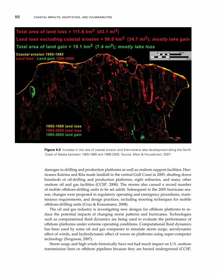
86 CoAsTAl ImpACTs, AdApTATIon, And VUlnerAbIlITIes
damages to drilling and production platforms as well as onshore support facilities. Hur-ricanes Katrina and Rita made landfall in the central Gulf Coast in 2005, shutting down hundreds of oil-drilling and production platforms, eight refineries, and many other onshore oil and gas facilities (CCSP, 2008). The storms also caused a record number of mobile offshore-drilling units to be set adrift. Subsequent to the 2005 hurricane sea-son, changes were proposed in regulatory operating and emergency procedures, main-tenance requirements, and design practices, including mooring techniques for mobile offshore-drilling units (Cruz & Krausmann, 2008).
The oil and gas industry is investigating new designs for offshore platforms to re-duce the potential impacts of changing storm patterns and hurricanes. Technologies such as computational fluid dynamics are being used to evaluate the performance of offshore platforms under extreme operating conditions. Computational fluid dynamics has been used by some oil and gas companies to simulate storm surge, aerodynamic effect of winds, and hydrodynamic effect of waves on platforms using super-computer technology (Ferguson, 2007).
Storm surge and high winds historically have not had much impact on U.S. onshore transmission lines or offshore pipelines because they are buried underground (CCSP,
Figure 4-2 Increase in the rate of coastal erosion and thermokarst lake development along the North Coast of Alaska between 1955-1985 and 1985-2005. Source: Mars & Houseknect, 2007.
Vulnerability and Impacts on Human development 87
2008); however, offshore pipelines were damaged in relatively large numbers during Hurricanes Andrew, Ivan, and Katrina. Hurricane Andrew damaged more than 480 pipelines and flow lines, most of which were in less than 30 meters of water. Hurricane Ivan resulted in approximately 168 pipeline damage reports, although the vast major-ity of Gulf of Mexico offshore pipelines performed well during its passage. The Bureau of Ocean Energy Management, formerly known as the U.S. Minerals Management Ser-vice, indicates that 457 offshore oil and gas pipelines were damaged as a result of Hur-ricanes Katrina and Rita (CCSP, 2008). Examples of the potential effects of increasing wave heights and storm surge on energy-related operations in the OCS and coastal zone include:
• Damage to offshore and coastal drilling and production platforms as well as onshore support facilities due to higher surge, winds, and waves;
• Wave energy impacts on transportation infrastructure such as bridge decks and supports; and
• Pipeline exposure and damage.
4.4 human health Impacts and Implications
Climate-driven changes in temperature, precipitation, sea level, and the hydrologic cy-cle affect coastal-related human health and well-being. Direct health impacts and risks are those resulting from the climate-related environmental exposure itself, which in-clude extreme weather events. Indirect health impacts and risks result from exposure to climate-driven changes in ecological systems and habitats, which in turn affect human health and well-being. Both direct and indirect pathways affect health and well-being across time scales from days to decades and depend on complex interactions among and between environmental exposures, human-risk factors, social behavior, and the cultural, economic, and political contexts (Frumkin, 2008; Portier, 2010).
• Direct climate-related changes that affect coastal health outcomes include extreme weather events such as heat and cold extremes; drought and flooding; hurricanes, cyclones, and tropical storms; and sea-level rise and storm surges. Health outcomes include changes in heat-related illness and death; illness and injury during drought; flood or emergency response; injury and death from hurricane, cyclones, sea level, and storm surge directly; and related impacts on food supply and mental health during and after an emergency evacuation or extreme weather event.
• Indirect climate-related changes that affect coastal health outcomes include changes in coastal water temperature, quality, and chemistry; coastal watershed runoff; coastal habitats and species; and land-use patterns. These can lead to ecologically mediated health risks such as water-borne illnesses, vector-borne disease, and altered availability and quality of the coastal food supply. In addi-tion to these health outcomes, long-term changes can affect livelihoods, commu-nity structures, and aesthetic values, which can affect the local and regional economies and community resilience in turn.
88 CoAsTAl ImpACTs, AdApTATIon, And VUlnerAbIlITIes
Underpinning the extent of the human health impact of climate change are the so-cial structure, which could include close family or community ties; the cultural con-text, which includes socio-economic status, cultural traditions, family and community dynamics, gender, and religion; and the economic and political context, which include population demographics, and the roles of community and political leaders. In addition to long-term oceanographic and biological data, social and public health data includ-ing emergency room visits, reported illnesses, recreational usage of beaches and coastal waters, livelihood and economic growth data, and household income is needed. The fol-lowing discussion outlines the potential direct and indirect environmentally mediated impacts of climate change on human health and well-being as well as sentinel species and habitats that can serve as integrative indicators of ecosystem level risks to human health.
Direct Impacts
HEAT AND HEAT WAVES. Health outcomes from increasingly frequent and severe heat events include heat exhaustion, heat stroke, severe cramps, and death. Exposure to increased average temperatures alone may exacerbate pre-existing conditions related to chronic respiratory, neurological, or cardiovascular diseases (Luber, 2008). During the 2006 California heat wave, over 160 Californians died, and 16,166 excess emergen-cy room visits and 1,182 excess hospitalizations occurred statewide. Children aged 0-4 years of age and adults over 65 years of age were at greatest risk. Emergency room visits also showed significant increases for acute renal failure, cardiovascular diseases, diabe-tes, electrolyte imbalance, and nephritis (Knowlton, 2006). Chronically ill individuals 65 and older are more susceptible to heat effects than the general population. As coastal populations increase, and the demographics include higher risk populations, the health effects from prolonged heat exposure can be expected to increase as well. This is well demonstrated in coastal urban environments such as New York City, but additional re-search is needed to further differentiate expected impacts specifically in coastal environ-ments (Knowlton et al., 2008).
DROUGHT AND FLOOD. In a recent report, the CDC (2010) noted that drought effects can be manifested in a number of health-related impacts including compromised quality and quantity of potable water and food, diminished living conditions, increased risks associated with recreation, impacts to mental health, increased incidence of disease, and additional stress on vulnerable populations. In addition, drought leads to parched habitats, and some coastal areas may be more prone to forest fires, which can exacerbate asthma and other aero-allergenic and respiratory diseases. In addition to the impacts to human development discussed in the preceding sections, flooding events pose the direct risk of death. Longer term human health impacts are related to infrastructure--ensuring that hospitals and urgent care facilities are accessible to the local population during ex-treme events, that evacuation plans are in place and successfully communicated, and that emergency personnel and first responders are prepared.
HURRICANES AND STORM SURGE. Coastal storm-related health outcomes include changes in heat-related illness and death, injury and death from hurricane and storm
Vulnerability and Impacts on Human development 89
surge directly, illness and injury during emergency response, and mental health effects during and after an emergency evacuation or other extreme weather events. Longer-term health implications include potential effects on mental health and food supply.
Hurricanes and floods can lead to standing water and accumulated debris that create new habitats for mosquitoes and other disease-carrying agents like rats or roaches that humans had less exposure to and that were not abundant in that ecosystem before. Ill-ness also increases in extreme situations in which local populations have to be housed in large, temporary-living spaces such as the Superdome during and after Hurricane Katrina. Existing water sanitation and hygiene systems are not generally designed to provide clean water and handle waste under these circumstances. Given the chaos, dis-ruption, dislocation, potential unemployment, and general uncertainty during extreme climatic events, a potential longer-term impact is an increase in mental-health issues associated with natural disasters and other sources of dislocation, unemployment, or forced migration (Berry, 2010; Portier, 2010).
After hurricanes and floods, a lack of confidence in fish and coastal food supply can affect both health and economic interests. After Hurricane Katrina, consumers had a hard time believing that Gulf of Mexico seafood was safe to eat even though extensive sampling and chemical analysis showed that was the case (Hom et al., 2008). A lack of consumer confidence in fish and food from the sea, such as in the aftermath of Hurricane Katrina, has both human health and economic consequences (see Sandifer et al., 2012 for more details). Ensuring access to safe food supply from the sea necessitates establishing baselines and trustworthy monitoring and evaluation and communication tools, espe-cially as our habitats and ecosystems are impacted by more frequent or severe events.
Indirect Impacts
WATER-RELATED ILLNESS. Human-health risks include changes in the concentra-tion, distribution, or virulence of pathogens, biological toxins, and chemical contami-nants in our coastal waters. These can directly impact recreational use; drinking-water quality: the quantity and quality of the food supply from coastal waters and wetlands; the economic productivity and livelihoods of fisheries, tourism, and real estate; and aes-thetic and cultural use (Portier, 2010).
Pathogens. The capacity of water sanitation and hygiene infrastructure is an impor-tant determinant of climate-related human-health impacts; for example, combined sewer overflows (CSOs) occur when rainwater runoff, domestic sewage, and industrial wastewater that are collected in the same pipe overflow during heavy precipitation or storm surge events. Runoff during CSOs can contain pathogen and chemical contami-nants that end up directly in our coastal waters (Fong, 2010). In addition, livestock and agricultural feedlots are known sources of coastal pollution that directly affect coastal water quality and recreational use. Water sanitation facilities are another source of pol-lutant. If the intensity of rainfall or flooding events are expected to increase, then coastal pollution from these sources can be expected to increase as well unless management and infrastructure changes are made.
Over 40 million Americans in approximately 772 cities rely on combined sewer sys-tems for stormwater and snowpack runoff as well as untreated domestic and industrial
90 CoAsTAl ImpACTs, AdApTATIon, And VUlnerAbIlITIes
waste management (EPA, 2011). In the Great Lakes, extreme precipitation events may overwhelm the combined sewer systems and lead to overflow events that can threaten both human health and recreation in the region. Projected increases in heavy rainfall and lake water temperatures, in addition to decreased lake levels, would all be expected to contribute to beach contamination in the future (McLellan, 2007; Patz, 2008).
Biological Toxins. Certain species of marine algae are considered harmful, either through direct consumption or inhalation of aerosolized biological toxins like those that occur during Red Tide events in Florida. Harmful algal blooms (HABs) are increasing in frequency, intensity, and duration in freshwater and marine environments globally (Gilbert, 2005; van Dolah, 2000). The role of climate change in this expansion is unclear and the physical and biological ocean interactions are extremely complex, but current research indicates that: 1) the range expansion of warm-water species occurs at the ex-pense of cold-water species that are driven poleward; 2) the seasonal window of growth of some species will increase, leading to earlier and, possibly longer and more intense blooms; 3) these changes in the timing and location of blooms will have secondary ef-fects for marine food webs and the transfer of toxins through marine food webs (Hal-legraeff, 2010). A growing body of literature suggests that the geographic incidence, frequency, and intensity of harmful algal blooms are likely to increase in the future as a result of an anthropogenically changing climate (Moore et al., 2008, 2010, 2011). In the Puget Sound, sea-surface temperatures affect the timing and onset of certain harmful algae. The window of opportunity for harmful blooms of Alexandrium canenella, which causes paralytic shellfish poisoning, is likely to shift by up to two months over the next ten years based on climate-driven changes in the coastal ecosystem (Moore, 2010, 2011). Some effects may be seen within the next 30 years and perhaps as early as the next de-cade (Moore et al., 2011). Understanding algae and related biotoxin production will lead to better predictions of risks related to climate change (Moore, 2008).
CHEMICAL CONTAMINANTS. Alterations in the timing and intensity of storm events associated with climate change are expected to deliver different, and in many cases, in-creased loadings of chemical contaminants to surface waters (Kundzewicz et al., 2009). These contaminants will be transported downstream and enter coastal ecosystems where they can be taken up by marine fish and shellfish and both directly and indirectly affects on human health and well-being. Dickhoff and others (2007) describe many direct risks to human health posed by chemical contamination of seafood. These risks come primar-ily from persistent and bioaccumulative substances such as polychlorinated biphenyls and methylmercury. In addition, the presence of contamination can often result in regu-latory and advisory actions aimed at reducing consumption of seafood from affected coastal areas. Because consumption of seafood is generally believed to confer substan-tial human-health benefits, reduced human consumption of seafood presumably has a negative, indirect effect on human health (Dickhoff et al., 2007).
VECTOR-BORNE AND ZOONOTIC DISEASE (VBZD). The incidence of VBZD in the U.S. will likely increase under anticipated climate change scenarios. Efficient vector and reservoir life cycles and transmission dynamics depend on optimal temperatures, hu-midity levels, and habitats, including coastal waters and shoreline habitats. Changes in
Vulnerability and Impacts on Human development 91
precipitation, temperature, and humidity will shift habitats that allow insect and ani-mal vectors to survive and transmit disease in new, previously unsuitable areas. Coastal and marine changes will affect ocean and coastal ecosystems by influencing community structure, biodiversity, and the growth, survival, persistence, distribution, transmission, and severity of disease-causing organisms, vectors, and marine and terrestrial animal reservoirs (CDC, 2009).
Changes in climate will affect the habitat, reproduction rates, and transmission dy-namics for: mosquitoes that carry malaria, yellow fever, and dengue; ticks that carry Lyme disease; and rodents that carry a variety of diseases such as those related to Hanta Virus and plague. As the habitats for these disease vectors are expected to shift north-ward, so too does the disease risk (Portier et al., 2010). The range of mosquito vectors is expected to shift northward with warmer temperatures and humidity, coupled with changes in coastal habitats and sea level. For instance, the habitat for two malaria vec-tors, Anopheles albimanus and Anopheles pseudopunctipennis, which is currently restricted to warmer climates, will expand northward into the U.S., but extreme conditions such as prolonged drought or excessively elevated temperatures can also bring that cycle to a stop and reduce risk in those areas. With the loss of predators, which changes predator-prey relationships, insect and marine and terrestrial animal vectors and reservoirs may increase or shift their range, which would necessitate either chemical or mechanical con-trols (CDC, 2009).
How much the recent dengue outbreaks in the U.S. are related to climate variability is unclear, but climate is likely one of the drivers (CDC, 2012). Similarly, the role of marine animals in zoonotic transmission under changing climate regimes is not well un-derstood (Portier, 2010). A lack of understanding of these complex VBZD transmission dynamics makes predicting climate-related changes difficult (CDC, 2009).
FOOD AND NUTRITION. Climate also poses several direct human-health risks specifi-cally associated with food from oceans and estuaries from consumption of contaminated food, decreased nutritional value of compromised or stressed food, lack of availability or change of access to food, which will be especially impactful for subsistence-food ani-mals (Portier et al., 2010). Climate change is expected to impair seafood safety through changes in chemical and biological risks; in particular, toxic metals, organic chemicals residues, algal toxins and pathogens of both humans and marine organisms (Marques, 2010). Climate change may lead to changes the occurrence of Vibrio species, a type of bacteria ubiquitous in the marine environment, some of which can cause cholera, gastro-intestinal illness, and serious, if not fatal, wound infections. Vibrio outbreaks have been related to changes in water temperature and changes in salinity (Colwell ,2008; Emch ,2008; Johnson, 2010; Turner, 2009) and can be monitored and predicted with a combina-tion of in-situ and satellite observations (Blackwell, 2008; Phillips, 2007).
The abundance and distribution of fish stocks are known to change as water tem-peratures and circulation patterns change. This affects human health directly in terms of available protein as well as economic productivity and cultural or tribal aspects of coastal-community health. In addition, little is known about the changes in nutritional quality or health of the fish as related to climate (Portier et al., 2010).
SENTINEL HABITATS AND SPECIES. Key habitats and certain marine mammals can
92 CoAsTAl ImpACTs, AdApTATIon, And VUlnerAbIlITIes
signal climate-related change in coastal conditions that can affect human health (Bossart, 2011; Rose, 2009). Sentinel marine mammals can serve as integrative integrators of hu-man-health risks; for instance, domoic acid (DA) exposure and related stranding and health risks in sea lions off the coast of California provide insight into human-health risks of DA exposure (Goldstein, 2009). Information from monitoring sentinel tidal creeks can demonstrate the need for screening of shellfish and other seafood for biotox-ins, pathogens, or chemical pollutants (Garner, 2009).
In summary, the impacts on human health and well-being are complicated, are me-diated by our individual- and social-behavioral constructs, and must be considered in the larger social, political, and cultural context. Although scientific advances in this field are being made, they are slow, incremental, and insufficient in size, scope, and duration to inform the science and policy choices that lie ahead. This is due in large part to the long-term nature and extent of the research collaborations required as well as the lack of sustained assistance, which should include the collection and maintenance of long-term physical, biological, and public health data that can be used for monitoring and research to give us early warning indications and inform longer-term risk predictions (Jochens, 2010; Portier, 2010).
4.5: Implications for Coastal Military Installations and readiness
Climate-related changes in global and regional temperatures, precipitation patterns, and sea level, as well as increasing coastal storm extremes and extended polar ice melt sea-sons, can impact Department of Defense (DoD) coastal installations and associated mili-tary readiness in numerous ways, including:
• Diminished capacity to sustain troop combat operational readiness if training and testing opportunities are reduced at coastal military installations;
• Comprised readiness, especially during extreme climatic events, of military personnel, facilities, and materiel assets for global power projection via combat service support, which is dependent, in part, on secure and properly func-tioning coastal installations and, in some cases, supporting civil transportation infrastructure; and
• Increased costs, inefficiencies, and response time for military operations in the coastal zone due to loss or degradation of natural resources and infrastructure at coastal installations as a result of sea-level rise or changes in the intensity of climate extremes.
In addition, sprawl, incompatible land use and other forms of encroachment on- and off-installation may operate in synergistic combination with climate change and have the potential to overwhelm the adaptive capacity of installations (DoD, 2011).
Coastal Military Installation Climate- and Global-change Challenges
The National Intelligence Council (NIC, 2008) explored the national security implica-tions of climate change in select countries and regions to characterize the extent that
Vulnerability and Impacts on Human development 93
anticipated effects may contribute to inter- and intra-state migrations, cause economic hardships, result in escalated social tensions, and lead to state instabilities. The onset of such crises has the potential for impacting and evolving DoD’s roles and missions. More research and study is needed to assess climate-environment-migration relationships. With a better understanding of these relationships, the readiness roles and missions of supporting military installations may need re-alignment to maintain U.S. national secu-rity (NIC, 2008).
Coastal-installation readiness, in particular, can be challenged as a result of climate-related environmental stressors and drivers that include:
• Changing weather patterns and extreme temperature, precipitation, and coastal storm events;
• Rising sea levels and subsiding or eroding land masses; • Disruptions to the biosphere that have complex repercussions on ecologic
sustainability;• Evolving land and water resources use patterns and management practices on
and off installation;• Production, accumulation, and migration of environmental contaminants on
lands and waters; and• Loss and degradation of habitats for protected threatened and endangered fish
and wildlife species (DoD, 2011).
Although DoD leadership has recognized and is continuing to study these chal-lenges, military commanders often are consumed with addressing daily tactical mis-sion requirements, which limits the opportunity to strategically incorporate the issues of climate change over extended future time scales. Technical guidance and capabilities needed to distill climate change information, whether as explicit predictions of future conditions or as scenarios, to the impact level at military installations is currently in-sufficient, although DoD is actively pursuing study of these needs. Recent interviews among DoD personnel at selected installations including Fort Benning, GA and Naval Base Norfolk, VA suggest that climate change is not fully realized as an inevitable threat in the near future. Although climate change forecasts are being discussed with higher frequency among DoD managers, a low level of awareness exists of the empirical knowl-edge base supporting global climate change predictions or scenario use nor any recogni-tion of the need for contingency planning (Noblis, 2010). Moreover, climate change is considered to be a regional phenomenon with insufficient relevance for consideration at specific local installations; in other words, most DoD managers believed that not enough information was available to implement climate change planning into current manage-ment activities (Noblis, 2010).
Deferring actions to manage potential climate change risks and uncertainties may exacerbate future impacts; however, the impact of delayed action can be addressed to enable:
1. Sustaining development of effective plans, programs, and budgets;
94 CoAsTAl ImpACTs, AdApTATIon, And VUlnerAbIlITIes
2. Carrying out effective systems analysis;3. Developing credible cost estimates; and 4. Creating timely and meaningful future defense plans (Cordesman, 2009).
A comprehensive, integrated, and science-based approach is needed to quantify sys-tems-scale operational risks of climate change for achieving military decision-making effectiveness (Noblis, 2010).
Coastal Installation Vulnerabilities and Combat Service Support Readiness
The 2010 Quadrennial Defense Review calls for a comprehensive assessment of all in-stallations to assess the potential impacts of climate change on DoD missions and to adapt as required (DoD, 2010). Vulnerabilities of coastal installations can be manifested through impacts to natural resources that support operations and training exercises, deterioration of built infrastructure and equipment that support combat service sup-ply, and direct and indirect impacts of climate-related disasters (Pollner et al., 2009). All of these vulnerabilities have practical implications for military readiness. Diminished quality of training and testing could lead to degradation of military personnel under-standing and skill in executing combat strategies and tactics, whereas impairments to a coastal installation’s combat service supply mission has the potential to diminish global-power projection capability during a crisis response.
Coastal storms and sea-level rise in combination have the potential to impair installa-tion infrastructure that supports combat service support missions. Accelerated sea-level rise will exacerbate the episodic effects of coastal storms, cause inundation of low-lying land areas, induce sustained geomorphologic and environmental changes, and alter har-bor topography, bathymetry, currents and salinity. These events may impact access to and use of military installation assets and increase maintenance requirements for coastal facilities. Resulting requirements may include increased dredging operations, dredged materials placement needs, modification of dock facilities, and the need to harden fa-cilities and coastal zones against hazard effects. Installations in which assets are located close to current sea levels will be subject to increased groundwater salinity, higher wa-ter tables, and increases in periodic flooding, which will require increased stormwa-ter pumping and drainage capacity, maintenance for corrosion control, and flood risk reduction. In addition, the regional interdependency of installations during extreme coastal-storm events with surrounding civil electrical power and communication net-works, roads, railways, and potable water distribution systems may result in increased installation vulnerability due to climate impacts on systems and facilities external to the installation.
Coastal storm risk assessment and management of military assets can be informed by the characterization of extreme storm events based on historical experience and storm-surge modeling. By contrast, sea-level rise is gradual even though the rates of change that are expected this century (see Chapter 2) are unprecedented in terms of historical U.S. military experience. Moreover, the uncertainties about future sea-level-rise rates preclude the establishment of a best estimate of sea-level rise during the remainder of this century; hence, a single, most probable trajectory for adaptation to sea-level rise is not available. This poses a non-stationary risk to coastal military installations, because
Vulnerability and Impacts on Human development 95
the fundamental operation requirements of many of these facilities are coastal- or water-side-dependent. A range of global sea-level change scenarios (see Chapter 2) was devel-oped by an expert panel convened as part of the NCA to provide Assessment teams with scenarios for risk-based vulnerability and impact assessment. The four sea-level-change scenarios provided range from 0.2 meter to 2.0 meters through 2100. Based on the risk tolerance of their decisions, stakeholders such as DoD can decide which of these sce-narios to use to guide their vulnerability impact assessment and adaptation decisions.
Increasingly, many coastal installations are taking on additional missions and ten-ant units with force restructuring and demands of overseas contingency operations. In-creased numbers of installation tenants and training mission requirements may further exacerbate training capacity and scheduling flexibility limits imposed by ongoing cli-mate change. The potential for climate change-related installation realignment or clo-sure, which also could translate into regional economic losses, is also a risk.
Operations and Training Readiness and Natural Resource Impacts
Impacts of climate change on natural resources can reduce the capacity of military instal-lations to support operations and training by changing training conditions and degrad-ing the utility of these assets for training. Physical constraints on access to training lands and waters resulting from extreme weather events have short-term effects on training and operations and also can damage roads and other infrastructure. Extreme heat events can require reductions in personnel activity levels. Extreme heat and drought events and high fire risk conditions also can preclude use of pyrotechnics, grenade simulators, and live-fire training with tracers to reduce the chance of wildfires. Extreme storm events and associated lightning, wind, and flooding risks can temporarily limit access to and degrade coastal lands and waters for training as well as personnel and materiel transit.
Impacts of climate change on installation natural resources can reduce the ability of installations to meet environmental regulatory requirements, which can lead to restric-tions on access to training and testing lands and waters. Because current research indi-cates that global climate change is already having significant impacts on both vegetation patterns across North America (Coops & Waring, 2001; Waring et al., 2011) and global bird-population distributions (Wormworth & Mallon, 2006), understanding this situa-tion and providing better training and information to DoD managers is relevant. Habitat transition or modification as a result of climate change may result in increased chal-lenges for installation managers to maintain the population status of species that are listed as endangered or threatened under the U.S. Endangered Species Act of 1973 (7 U.S.C. § 136, 16 U.S.C. § 1531 et seq.), while avoiding the increased potential for listings of species that are not currently listed. The construction of compensatory natural re-sources management features can be costly and has the potential to escalate. Terrestrial land management and training exercises could become restricted spatially and, as a re-sult, cause increased local ground disturbances and changes that degrade water quality by increasing waterway sedimentation and nutrient loading. In addition, amphibious training space could become restricted as habitats and buffers critical for sea turtles and shore birds decrease or as changes in barrier island and coastal marsh configuration due to sea-level rise and storm activity reduce available training space. These changes in quality, quantity, and distribution of natural assets may affect the DoD’s ability to meet
96 CoAsTAl ImpACTs, AdApTATIon, And VUlnerAbIlITIes
operational tempos and reduce scheduling flexibility, such as in reduction of installation capacity to support land-based and amphibious training exercises.
Increased temperatures and potential changes in precipitation patterns may require modification of prescribed burn programs, which are an important component of listed and at-risk species management on many installations. Increased coastal storm intensity and sea-level rise may cause losses and conversions of wetlands, barrier islands, and shorelines to open water and, if accompanied by high runoff events, could result in syn-ergistic impacts to natural and built infrastructure.
DoD Requirements and Programs for Vulnerability and Impact Assessments and Adaptation Planning
Three levels of risk-based impacts on DoD installations can be identified. At the high-est level of impact, an installation may no longer be able to support current and fu-ture mission requirements. At an intermediate level of impact, missions could still be accomplished but would require adaptive actions to prevent or remediate impacts, which could carry high costs and require significant time for planning and implemen-tation. Other impacts at this level could be acute, such as coastal-flooding events, with high short-term costs and short-term disruption, but would not prevent mission accom-plishment over the long-term. At the lowest level of impact, operations may need to be modified but could be accomplished within established processes with no significant commitment of additional resources.
DoD requires actionable climate information and projections at mission-relevant tem-poral and spatial scales for installation planning and adaptation. Climate information and decision tools are needed to support priority installation functions for maintaining effective testing, training, deployment, and force-sustainment capabilities, sustaining the built environment, complying with regulatory requirements, and keeping personnel safe. This will require increased understanding of the extent to which DoD planning and decision processes are influenced by climatic and meteorological factors. For climate data and analyses tools to be most relevant to DoD needs, they must be scalable across all DoD command echelons and provide comprehensive and comparable analyses across installations and regions for effective decision making. Effective use of available and new information and decision-support capabilities will require inter-agency coordi-nation regionally and nationally. In addition, interdependencies of installation facilities with surrounding areas will require close coordination with other affected stakeholders.
With proactive vulnerability and impact assessment, asset vulnerabilities and their sensitivities to changing stressors can be identified and serve as the necessary basis for planning and implementing resilient and adaptive management actions. Challenges include:
• Scientifically informing critical decisions that must be made through expert analysis of spatial-temporal complexities and uncertainties of stressor impacts on objectives-based installation mission performance that can serve the need for baseline assessment characterization at both the screening and detailed levels;
• Formulation, technical evaluation, distinctive comparison, and selection of competing alternative management actions;

Vulnerability and Impacts on Human development 97
• Developing and transferring a decision-support framework for effective appli-cation in the military community of practice; and
• Specifying protocols for collection and management of site-specific monitoring data and status metrics while minimizing time and expense requirements for continual focusing and application in assessment and management cycles.
DoD is currently developing policy, guidance, and technical knowledge and capa-bilities to effectively assess vulnerabilities and impacts and to plan for and adapt to potential climate change impacts. Development of technical support capabilities for vul-nerability and impact assessment and adaptation planning have been initiated through a range of efforts under the DoD Strategic Environmental Research and Development Program, Legacy Resource Management Program, and the U.S. Army Corps of Engi-neers’ Institute of Water Resources and Engineer Research Development Center.
98
Chapter 5
Adaptation and Mitigation
Key Findings
f Although adaptation planning activities in the coastal zone are increasing, they generally occur in an adhoc manner and at varied spatial scales dictated by on-the-ground needs and adaptation drivers in the particular area. Efficiency of adaptation can be improved through integration into overall land use planning and ocean and coastal management. High Confidence.
f In some cases, adaptation is being directly integrated, or mainstreamed, into existing decision-making frameworks regarding zoning and floodplain, coastal, and emergency management, but these frameworks are not always perfect fit and sometimes existing laws pose a barrier to implementation. Very High Confidence.
f Tools and resources to support adaptation planning are increasing but tech-nical and data gaps persist. As adaptation planning has evolved, recognition has grown regarding the need for detailed information that is compatible with organizational decision-making processes and management systems. Very High Confidence.
f Although adaptation planning has an increasingly rich portfolio of case studies that contribute to shared learning, the implementation of adaptation plans has proceeded at a much slower pace. Very High Confidence.
f Elements commonly found in adaptation plans include vulnerability assess-ments, monitoring and indicators, capacity building, education and outreach, regulatory and programmatic changes, implementation strategies, and a sector-by-sector approach. Very High Confidence.
f Although state and federal governments play a major role in facilitating adapta-tion planning, most coastal adaptation will be implemented at the local level. Local governments are the primary actors charged with making the critical, basic land-use and public investment decisions and with working with commu-nity stakeholder groups to implement adaptive measures on the ground. Very High Confidence.
5.1: Adaptation Planning in the Coastal Zone
In the ten years since the first National Assessment of the Potential Consequences of Climate Variability and Change, the science and policy landscape for adaptation has evolved sig-nificantly. Adaptation is emerging as an essential strategy for managing climate risk and
Adaptation and mitigation 99
a broad range of adaptation initiatives are being pursued across a range of geopolitical scales. This interest in adaptation has emerged from an increased awareness that climate impacts are unavoidable (Wetherland et al., 2001); a growing availability of knowledge, data, and tools for the assessment of climate risk; and the interest of government agen-cies, businesses, and communities in increasing their resilience to both current climate variability as well as future climate change. However, adaptation strategies are not generally mainstreamed into the policy apparatus of governments or the development plans of the private sector; in other words, adaptation strategies supplement existing planning efforts but often involve an effort on their own rather than being integrated into existing management and policy regimes. Also, although adaptation planning has an increasingly rich portfolio of case studies contributing to shared learning (Gregg et al., 2011), the implementation of adaptation plans has proceeded at a much slower pace.
Background on Adaptation Planning
Coastal adaptation planning will generally identify vulnerable coastal resources and likely impacts to these resources; define goals and specific adaptation actions based on the best available information; outline an implementation strategy; and create a plan for evaluating and monitoring results. Elements commonly found in adaptation plans are included below (see Box 5-1; Hansen & Hoffman, 2011; Heller & Zavaleta, 2009).
Inventory of Adaptation Planning
Adaptation-planning processes vary across spatial and jurisdictional scales. Because im-pacts from climate change will cross jurisdictional and sectoral boundaries, both plan-ning and implementation will generally require coordination at all levels of government including state, local, regional, and national and among a range of public and private entities. Planning processes typically involve coordination both vertically across local, state, and federal offices and horizontally across agencies and between counties, munici-palities, or states.
All major levels of government have an important role to play in facilitating adap-tation. At the federal level, agencies develop climate science and models, initiate pilot efforts with hundreds of local governments to plan for sea-level rise (Titus & Hudgens, 2010), and provide important technical support, data, and mapping that policymakers need for planning. As detailed in examples below, the federal government also allocates billions of dollars in public funds to pay for critical projects and services necessary for adaptation throughout the coastal zone such as hazard preparedness, disaster response, infrastructure development, and conservation projects. Similarly, state agencies distrib-ute state funds and provide oversight and technical support for adaptation planning; of-ten manage state-owned coastal lands and can acquire vulnerable properties; and have regulatory authority in all or parts of the state’s coastal zone. However, most adaptation will occur at the local level; local governments are the primary actors charged with mak-ing the basic land-use and public investment decisions that will be critical, along with working with community stakeholder groups, to implementing adaptive measures on the ground. The private sector also has a role; corporations, insurance companies, land trusts, and private individuals will have to make changes in how they manage assets
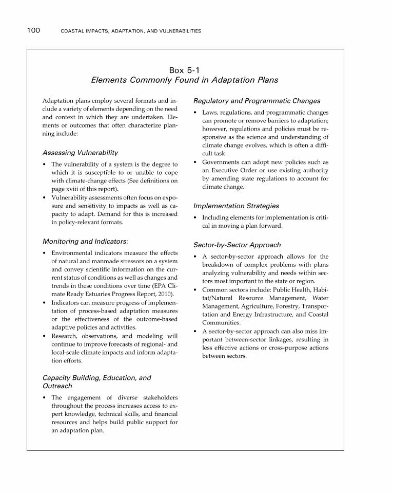
100 CoAsTAl ImpACTs, AdApTATIon, And VUlnerAbIlITIes
Adaptation plans employ several formats and in-clude a variety of elements depending on the need and context in which they are undertaken. Ele-ments or outcomes that often characterize plan-ning include:
Assessing Vulnerability
• The vulnerability of a system is the degree to which it is susceptible to or unable to cope with climate-change effects (See definitions on page xviii of this report).
• Vulnerability assessments often focus on expo-sure and sensitivity to impacts as well as ca-pacity to adapt. Demand for this is increased in policy-relevant formats.
Monitoring and Indicators:
• Environmental indicators measure the effects of natural and manmade stressors on a system and convey scientific information on the cur-rent status of conditions as well as changes and trends in these conditions over time (EPA Cli-mate Ready Estuaries Progress Report, 2010).
• Indicators can measure progress of implemen-tation of process-based adaptation measures or the effectiveness of the outcome-based adaptive policies and activities.
• Research, observations, and modeling will continue to improve forecasts of regional- and local-scale climate impacts and inform adapta-tion efforts.
Capacity Building, Education, and Outreach
• The engagement of diverse stakeholders throughout the process increases access to ex-pert knowledge, technical skills, and financial resources and helps build public support for an adaptation plan.
Regulatory and Programmatic Changes
• Laws, regulations, and programmatic changes can promote or remove barriers to adaptation; however, regulations and policies must be re-sponsive as the science and understanding of climate change evolves, which is often a diffi-cult task.
• Governments can adopt new policies such as an Executive Order or use existing authority by amending state regulations to account for climate change.
Implementation Strategies
• Including elements for implementation is criti-cal in moving a plan forward.
Sector-by-Sector Approach
• A sector-by-sector approach allows for the breakdown of complex problems with plans analyzing vulnerability and needs within sec-tors most important to the state or region.
• Common sectors include: Public Health, Habi-tat/Natural Resource Management, Water Management, Agriculture, Forestry, Transpor-tation and Energy Infrastructure, and Coastal Communities.
• A sector-by-sector approach can also miss im-portant between-sector linkages, resulting in less effective actions or cross-purpose actions between sectors.
box 5-1 Elements Commonly Found in Adaptation Plans
Adaptation and mitigation 101
and lands, build facilities, and manage risks. Finally, the nongovernmental sector has taken a lead role in gathering critical information and developing on-the-ground ap-proaches to foster adaptation.
Because of differences in scale, adaptation planning has taken many different forms: certain jurisdictions developed separate multi-sectoral adaptation plans (CA), devel-oped adaptation plans for individual sectors or impacts (MD), or included adaptation in plans to reduce greenhouse gas emissions (AK, FL, NY), while others mainstreamed adaptation by including consideration of climate impacts in other types of planning documents, laws, or regulations such as hazard-risk reduction plans (Lewes, DE) and coastal plans (RI and San Francisco, CA) (Arroyo & Cruce, 2012). This section provides examples of different types of planning efforts at several different spatial scales and lev-els of government. Because offering a comprehensive list is beyond the scope of this report, the authors selected efforts that highlighted different approaches, regions, and successes and challenges.
FEDERAL: The Federal Interagency Climate change Adaptation Task Force. In a 2009 Ex-ecutive Order, President Obama created the Task Force to coordinate adaptation plan-ning among federal agencies, tribes, and communities and to recommend how federal agencies can mainstream climate change considerations in programs and operations. In a 2011 progress report, the Task Force made key recommendations to the federal gov-ernment: 1) provide and translate data for decision-makers; 2) review the role of both private insurance and the National Flood Insurance Program in promoting resilience; 3) encourage pilot projects where federal agencies support local adaptation initiatives such as the EPA, HUD, and DOT Sustainable Communities Program; and (4) examine cross-cutting issues related to ocean and coastal resilience, such as ocean acidification and ecosystem-based management.
REGIONAL: West Coast Governors’ Agreement on Ocean Health (WCGA). After recognizing in September 2006 that adaptation will require a transboundary response, the governors of California, Oregon, and Washington signed the WCGA and created a regional part-nership for coastal management. The WCGA created ten Action Coordination Teams composed of state-agency staff and federal partners to study and develop approaches for cross-jurisdictional management of coastal resources. Teams are developing strate-gies to adapt to sea-level rise, coordinate on sediment management, and implement eco-system-based management approaches. The three states combined financial resources to commission an independent study of localized sea-level-rise projections from the Na-tional Research Council. This regional collaborative will be expanded to include Alaska and British Columbia through the Pacific Coast Collaborative.
STATE: North Carolina—Sea-level-rise Risk Management Study. North Carolina and FEMA are working to map future shoreline changes. This project will study hazard-mapping tools to evaluate how sea-level rise will change flooding along the state’s coast and pro-pose risk management strategies to reduce or avoid those flood risks.
LOCAL: Southeast Florida Regional Climate Change Compact. Palm Beach, Broward, Miami-Dade, and Monroe counties in Southeast Florida are collectively addressing adaptation. The counties developed a uniform approach to estimating and mapping
102 CoAsTAl ImpACTs, AdApTATIon, And VUlnerAbIlITIes
sea-level-rise scenarios and leveraged support from federal agencies that otherwise might have been split between individual counties.
TRIBAL: Swinomish Tribe, Washington—Climate Adaptation Action Plan. The Swinomish Tribe of Washington developed an adaptation plan for its reservation located where the lower Skagit River empties into Puget Sound. The Swinomish used scenario- and risk-based planning to assess vulnerabilities to their natural and human systems and cultural resources. Of particular concern to the Tribe are the impacts to natural resources from hard-armored responses to sea-level rise. The Reservation has 2,900 acres of tidelands that are integral to maintaining the Tribe’s fishing traditions. The plan recommends the Tribe use long-term planning to avoid environmental impacts to these resources.
PRIVATE: Northrop Grumman—Climate Impacts on the Newport News Shipyard. Northrop Grumman is studying vulnerabilities to its Hampton Roads, VA shipyard, which builds and maintains nuclear aircraft carriers. Hampton Roads is considered one of the most vulnerable regions to sea-level rise. The shipyard has 20,000 employees and has serviced approximately 800 ships and 30 carriers. Potential impacts to the shipyard include flood-ing of dry-docks, and inundation of residences, business, and transportation facilities
The Status of Coastal Adaptation Planning
With adaptation planning proliferating as a strategy for managing the risks of climate change to coastal systems, attention is beginning to shift toward evaluating how effec-tive such planning has been. The following sections demonstrate some strengths of ad-aptation planning to date, the emerging practices that are advancing the practice, and those aspects of adaptation planning that appear to be persistent challenges.
Strengths of Coastal Adaptation Planning
One of the most significant developments in coastal adaptation in recent years is the emergence of guidance that can support state- and local-level adaptation planning. For example, the International Council for Local Environmental Initiatives (ICLEI) – Lo-cal Governments for Sustainability, the University of Washington, and King County in Washington state prepared a guide entitled Preparing for Climate Change to lead stake-holders through the adaptation-planning process (Snover et al., 2007). In addition, ICLEI has developed an Adaptation Database and Planning Tool (ADAPT) to support adapta-tion planning in local governments. Similar guidance has been developed to address the specific circumstances of coastal communities and ecosystems. For example, NOAA’s (2010) report entitled Adapting to Climate Change: A Planning Guide for State Coastal Man-agers provides an overview of the implications of climate change for the coastal commu-nities and outlines a range of key considerations for decision making. Other guidance, such as the EPA’s report entitled Rolling Easements (Titus, 2011), is designed to provide detailed information on specific coastal adaptation strategies. Despite variation among these different types of guidance regarding the appropriate approach to take to adapta-tion planning (Preston et al., 2009), the availability and accessibility of such guidance provides a foundation for enhancing the capacity of federal, state, and local organiza-tions to take the first steps in planning for climate change on America’s coasts.
Adaptation and mitigation 103
By initiating coastal adaptation planning, government agencies and local communi-ties are educating themselves and others while building networks to share that knowl-edge among researchers, decision makers, and community members. One of the areas in which adaptation planning has been instrumental in expanding knowledge has been in the assessment of vulnerabilities and risks associated with climate change. For example, the Partnership for the Delaware Estuary undertook a series of case studies to examine the estuary’s vulnerability to climate change (Kreeger et al., 2011). Meanwhile, the State of New Jersey assessed the potential impacts of sea-level rise and coastal inundation for the state’s coastline as well as the associated socio-economic impacts (Cooper et al., 2005). Similar assessments have been conducted for individual municipalities including the City of New York and the City of Punta Gorda, Florida (Beever et al., 2009; New Your City Panel on Climate Change, 2010, also see Box 4.1).
Assessments of vulnerability and risk are also emerging from individual utilities and infrastructure managers. For example, as part of its adaptation planning, the City of New York’s Metropolitan Transit Authority assessed the potential impacts of climate change to the agency’s infrastructure and operations (Jacob et al., 2008). Meanwhile, King County, Washington assessed the implications of sea-level rise for waste-water management infrastructure (King County, 2008). Although the goals of adaptation plan-ning are broader than a simple assessment of potential vulnerabilities and risks associ-ated with climate change, such assessment activities are a key entry point for adaptation planning. Accordingly, researchers and practitioners have contributed to the expansion of methods and tools for assessing coastal risk (also see Section 5.3).
Emerging Planning Practice
As adaptation planning has evolved, recognition has grown regarding the need for de-tailed information that is compatible with organizational decision-making processes and management systems. In recent years, progress has been made in the integration of adaptation into spatial planning at the state, regional, and local levels. This has allowed adaptation planning to advance beyond the identification of potential policies and op-tions to more practical explorations of those options at spatial scales relevant to decision makers; for example, Miami/Dade County has developed a series of spatial flood-risk and sea-level-rise visualizations. Increasingly, spatial planning is integrating informa-tion on coastal risk with land-use planning; for example, regional planning agencies in Pennsylvania (Linn, 2010), Georgia (Concannon et al., 2010), and Florida (Merritt, 2010) have collaborated with local governments to create maps depicting which lands are like-ly to receive shore protection and which lands would be given up to the rising sea. The NOAA Sea Grant programs have conducted similar efforts in New York (Tanski, 2010) and North Carolina (Clark & Kassakian, 2010). A spatial planning exercise conducted by the U.S. Department of Transportation (U.S. DOT) in Cape Cod, Massachusetts ex-plored multiple scenarios of future development on the cape to explore interactions among coastal vulnerability, development, and maintenance of environmental amenity (U.S. DOT, 2011). Integrated approaches to spatial planning have also been applied in the cities of Punta Gorda, Florida (Beever et al., 2009); New York, New York (New York City Panel on Climate Change, 2010); and Boston, Massachusetts (Adaptation Advisory Committee, 2011).
104 CoAsTAl ImpACTs, AdApTATIon, And VUlnerAbIlITIes
The aforementioned Cape Cod study highlights another advance in adaptation plan-ning: the expansion of collaborative networks and stakeholder participation in the plan-ning process. Robust adaptation planning necessitates both expert knowledge regarding biophysical climate change impacts and regional and local knowledge regarding how those changes might impact valued human and ecological systems and the range of relevant policy responses. Adaptation planning is therefore increasingly undertaken through partnerships among federal, state, and local government agencies, research in-stitutions, and non-profit organizations. Such partnerships have facilitated knowledge transfers and supported adaptation planning efforts in Oregon (State of Oregon, 2010) and California (California Natural Resources Agency, 2009) as well as the cities of New York (New York City Panel on Climate Change, 2010) and Boston (Adaptation Advisory Committee, 2011). This has created greater opportunities for learning and enhanced the practical utility of adaptation planning.
Adaptation Planning Challenges
Despite the rapid expansion of coastal adaptation planning, challenges remain in trans-lating such planning efforts into increased coastal-systems resilience to the impacts of climate change (Berrang-Ford et al., 2011; Preston et al., 2011a). A central challenge is the availability of knowledge and tools that enable confident planning for the future; for example, considerable uncertainty persists with respect to projections of future sea-level rise as well as information regarding future demographic and economic trajectories (Preston et al., 2011b, see also Section 2.2). Guidance on flexible decision pathways is needed to assist decision makers with evaluating and staging adaptation decisions while recognizing that understanding of the future will always be imperfect. Constraints on financial and human resources within organizations may hinder attempts to manage such uncertainties (Moser & Ekstrom, 2010). Developing strategies for overcoming such constraints is therefore an important but often overlooked component of adaptation planning. In one constructive example, the City of Homer, Alaska intends to enact a sus-tainability fund to recruit staff and finance adaptation measures (City of Homer, 2011).
The challenges in implementing adaptation plans extend beyond the resourcing of organizations. Although many adaptation actions for coastal areas can be categorized as “no regrets” actions that pose few opportunity costs (California Natural Resources Agency, 2009), more substantive actions may have larger policy or legal hurdles. For example, restrictions on development in vulnerable areas or the implementation of planned retreat may be challenged as regulatory “takings” that require just compensa-tion (Craig, 2010), which may force tradeoffs between coastal protection and property rights. Overlapping and sometimes conflicting laws, often designed without consider-ation of a changing climate, can prevent the adoption of adaptive measures. In the Alli-gator River National Wildlife Refuge/Albemarle-Pamlico Peninsula Climate Adaptation Project, the Nature Conservancy and the U.S. Fish and Wildlife Service set out to evalu-ate the effects of different adaptation strategies on areas likely to be impacted by sea-lev-el rise. The strategies included constructing oyster reefs to buffer shorelines from waves and storm surges, restoring the natural hydrologic regime and associated wetland sys-tems, and planting salt- and flood-tolerant species, several of which required federal and state permits. The permit required through the state’s Coastal Area Management Act
Adaptation and mitigation 105
took eight months to acquire because the materials used to construct the oyster reef did not conform to the state’s concept of fill material and the permit was elevated to a major permit (Gregg et al., 2010).
Although some adaptation-planning efforts acknowledge these governance challeng-es and articulate the actors and actions needed to implement particular policies, more comprehensive policy frameworks for adaptation implementation are needed to create the enabling conditions for coastal adaptation. Finally, although available guidance for adaptation planning emphasizes the need for monitoring and evaluation of implemen-tation (Snover et al., 2007), these elements are often missing from adaptation plans in practice (Preston et al., 2011a).
5.2 Coastal resource Management and restoration in the Context of Climate Change
Many issues that coastal managers are dealing with already on a daily basis are likely to be exacerbated by climate change; therefore, in a certain sense, planning for climate change will not require a new set of tools or planning strategies but is rather a matter of rethinking existing coastal management and restoration priorities in light of a new set of climate endpoints or scenarios. Of major concern are:
• Ecosystems that are already experiencing stress associated with land-use change, hydrologic alteration, and other non-climate perturbations;
• Already vulnerable coastal resources that are also highly sensitive to changes in climate such as temperature increase and precipitation change; and
• Natural and cultural resources at risk due to their geography.
With an emphasis on the priorities listed above, coastal managers are beginning to specifically consider climate change in planning and on-the-ground implementation of coastal resource management and restoration efforts. In some instances, coastal manag-ers are assessing how climate change will affect the ability of a given restoration project to achieve existing restoration goals and objectives (NWF, 2011); in other cases, manag-ers are thinking about climate change from a broader perspective with an aim towards developing and implementing resource management or restoration practices to protect against, remedy, or increase ecosystem resilience to the impacts of climate change.
Climate Change Considerations for Coastal Resource Management and Restoration
Some of the most challenging elements associated with natural, cultural, and economic coastal resource management in light of climate change are associated with coastal and watershed influences of storms and extreme events, sediment management, and the impacts of sea-level rise on tidal wetland ecosystems and cultural resources. Climate change considerations for such management needs are highlighted below.
MANAGING FOR STORMS AND EXTREME EVENTS. Prudent coastal resource man-agement and restoration strategies will consider the gradual change expected to occur
106 CoAsTAl ImpACTs, AdApTATIon, And VUlnerAbIlITIes
due to climate change as well as likelihood of moderate-to-severe damage to result from episodic extreme events such as hurricanes, tropical storms and nor’easters.
Although the damage to human infrastructure from hurricanes and tropical storms can be substantial, both tropical and extra-tropical systems have the potential for signifi-cant damage to coastal natural resources as well. The persistent loss of more than 135 square miles of coastal wetland throughout the Louisiana coastal zone in the two years between November 2004 and October 2006 is associated primarily with the passages of Hurricanes Katrina and Rita (Couvillion et al., 2011). By October 2008, Hurricanes Gustav and Ike resulted in the additional persistent loss of almost 95 square miles of wetland in Louisiana (Couvillion et al., 2011).
Disruption of coastal resources from storms goes beyond the physical disruption from storm surge. In 1972, a weak Hurricane Agnes, combined with a non-tropical low pressure system over the U.S. Mid-Atlantic region, dumped more than 10 inches of rain throughout much of the Chesapeake Bay watershed. Agnes-induced runoff delivered 32 million metric tons of dry sediment from the Susquehanna River into the Chesapeake Bay and the Bay’s salinity gradient was moved downstream more than 30 miles (NOAA, 2003). The influx of nutrients and sediments killed upwards of two-thirds of the Bay’s submerged aquatic vegetation and caused significant impacts to its oyster and clam populations.
SEDIMENT MANAGEMENT. The acceleration of global sea-level rise, coupled with storm impacts and hydrologic alteration of rivers that drain to the coast, calls for a greater emphasis on regional sediment management planning (Gulf of Mexico Alliance, 2009). Regional sediment management is a strategy employed to improve management of sediment resources in many coastal areas. Strategies such as beach nourishment are used in many areas to supplement natural-sediment transport mechanisms and maintain buffers between public and private infrastructure and coastal waters. Additionally, the relocation of sediment is a large element of many coastal management strategies. This includes moving sediment out of undesirable places as well as placing sediment into desirable areas. In general, improving the management of available sediment resources could minimize costs for moving sediment while concurrently creating and maintaining coastal features to decrease coastal risk. As our knowledge of climate, sea-level rise, and sediment dynamics increases, and the tools available to identify and quantify sediment resources improve, coastal regions will be able to more strategically manage available sediment resources.
One significant climate change impact for the entire Gulf of Mexico coastal region is increased sea-level rise leading to increased coastal erosion and wetland loss. The need for sediments is substantial now and is likely to increase significantly in future decades as sea-level rise accelerates over current rates (Gulf of Mexico Alliance, 2009). In light of such climate forces, sediment is often viewed as a resource for building wet-lands that offset the losses that many coastal areas are experiencing; for example, the Coastal Protection and Restoration Authority (CPRA) of Louisiana has constructed in-creasingly larger and more comprehensive marsh creation projects utilizing a number of sediment sources. Barrier islands are maintained and marsh areas are constructed in areas that have eroded or degraded. These areas provide important ecosystem services related to recreation and fisheries and storm-risk reduction for coastal communities and
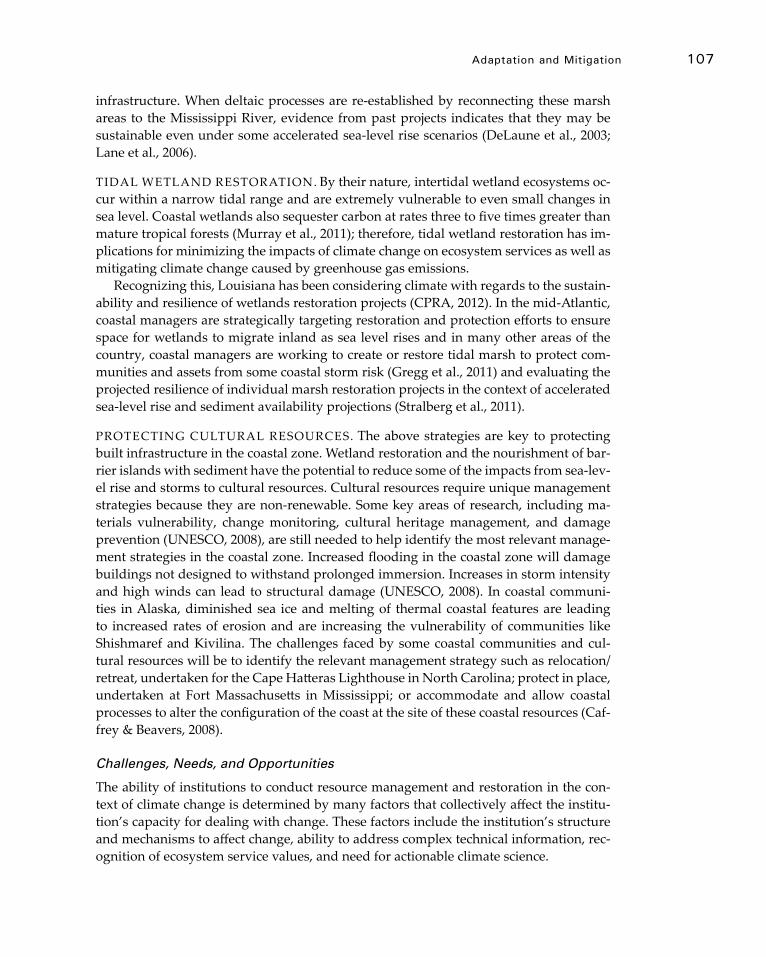
Adaptation and mitigation 107
infrastructure. When deltaic processes are re-established by reconnecting these marsh areas to the Mississippi River, evidence from past projects indicates that they may be sustainable even under some accelerated sea-level rise scenarios (DeLaune et al., 2003; Lane et al., 2006).
TIDAL WETLAND RESTORATION. By their nature, intertidal wetland ecosystems oc-cur within a narrow tidal range and are extremely vulnerable to even small changes in sea level. Coastal wetlands also sequester carbon at rates three to five times greater than mature tropical forests (Murray et al., 2011); therefore, tidal wetland restoration has im-plications for minimizing the impacts of climate change on ecosystem services as well as mitigating climate change caused by greenhouse gas emissions.
Recognizing this, Louisiana has been considering climate with regards to the sustain-ability and resilience of wetlands restoration projects (CPRA, 2012). In the mid-Atlantic, coastal managers are strategically targeting restoration and protection efforts to ensure space for wetlands to migrate inland as sea level rises and in many other areas of the country, coastal managers are working to create or restore tidal marsh to protect com-munities and assets from some coastal storm risk (Gregg et al., 2011) and evaluating the projected resilience of individual marsh restoration projects in the context of accelerated sea-level rise and sediment availability projections (Stralberg et al., 2011).
PROTECTING CULTURAL RESOURCES. The above strategies are key to protecting built infrastructure in the coastal zone. Wetland restoration and the nourishment of bar-rier islands with sediment have the potential to reduce some of the impacts from sea-lev-el rise and storms to cultural resources. Cultural resources require unique management strategies because they are non-renewable. Some key areas of research, including ma-terials vulnerability, change monitoring, cultural heritage management, and damage prevention (UNESCO, 2008), are still needed to help identify the most relevant manage-ment strategies in the coastal zone. Increased flooding in the coastal zone will damage buildings not designed to withstand prolonged immersion. Increases in storm intensity and high winds can lead to structural damage (UNESCO, 2008). In coastal communi-ties in Alaska, diminished sea ice and melting of thermal coastal features are leading to increased rates of erosion and are increasing the vulnerability of communities like Shishmaref and Kivilina. The challenges faced by some coastal communities and cul-tural resources will be to identify the relevant management strategy such as relocation/retreat, undertaken for the Cape Hatteras Lighthouse in North Carolina; protect in place, undertaken at Fort Massachusetts in Mississippi; or accommodate and allow coastal processes to alter the configuration of the coast at the site of these coastal resources (Caf-frey & Beavers, 2008).
Challenges, Needs, and Opportunities
The ability of institutions to conduct resource management and restoration in the con-text of climate change is determined by many factors that collectively affect the institu-tion’s capacity for dealing with change. These factors include the institution’s structure and mechanisms to affect change, ability to address complex technical information, rec-ognition of ecosystem service values, and need for actionable climate science.
108 CoAsTAl ImpACTs, AdApTATIon, And VUlnerAbIlITIes
INSTITUTIONAL STRUCTURE/MECHANISMS.
It will be crucial to imbue all of our decisions (research, management, communications, and policy) with clear recognition as to the role climate change will play in their success or failure, and to incorporate uncertainty about the future into our planning.
Hansen & Hoffman, 2010: pg. 33
As discussed in the prior sections, consideration of climate change in coastal resource management and restoration efforts is growing in practice through a range of focused and exploratory efforts; however, in order to realize consideration of climate change, policies and/or directives are necessary to institutionalize consideration of climate change in coastal management and restoration. Policies and directives have been estab-lished, such as the Maryland Department of Natural Resources’ Climate Change Policy that directs the agency to “proactively pursue, design and construct habitat restoration projects to enhance the resilience of bay, aquatic and terrestrial ecosystems to the im-pacts of climate change and/or increase on-site carbon sequestration” (Maryland De-partment of Natural Resources, 2010: pg 14). Many more directives like this one will be needed, particularly at the national scale, in order for climate resilience to be realized.
TECHNICAL INFORMATION. Understanding the interactions between climate change and the range of physical, chemical, and biological characteristics of coastal re-sources is complex (see Chapters 2 and 3 for an explanation of the nature of these com-plexities). Likewise, ascertaining how to incorporate consideration of climate change into coastal resource management and restoration efforts is difficult. Although sizable scientific confidence supports the need for activities that reduce non-climate stressors, the effectiveness of the measures that help systems adapt to climate change is not as evi-dent, and their consideration requires a clear understanding of how a system functions and how it might be affected by climate change (Julius & West, 2008). In recognition of this need, a number of organizations, including non-profit, federal, state, and regional partners, have begun to develop frameworks (Figure 5-1) and exploratory guides to sup-port the integration of climate change considerations into the restoration efforts (Glick et al., 2011; Hansen & Hoffman, 2010; Kane et al., 2011).
VALUING ECOSYSTEM SERVICES. Recently, emphasis has been placed on the ser-vices that ecosystems provide, such as storm surge buffers, clean water, and migratory bird habitat. In some cases an actual dollar value can be placed on the services provided, which has created new incentives for financial investments by the government, private, and corporate sectors in coastal resource protection and restoration (Cooley & Olander, 2011). When managed effectively, protection or restoration of coastal ecosystems can provide mutual societal, ecological, and financial co-benefits. This is an important new concept because connecting the ecosystem services provided for greenhouse gas mitiga-tion purposes with adaptation needs is now conceptually possible. This may result in new mechanisms to fund costly adaptation strategies; for example, salt marsh restora-tion designed to be eligible for financial benefits such as carbon offset credits must dem-onstrate, among other factors, a life-expectancy of 75-100 years. In order to meet these criteria, the project design must take into account such external forces as sea-level rise,
Adaptation and mitigation 109
which ensures long-term ecological benefits such as the ecological viability of the marsh. The third concomitant benefit to ecosystem services realized by the salt marsh restora-tion is the societal benefit of living-shoreline protection provided to upland properties by existence of the marsh.
ACTIONABLE CLIMATE SCIENCE. With the growing awareness of the need for adap-tation, coastal resource managers are searching for immediate guidance on how to con-sider the implications of climate change, including sea-level rise, temperature increase, and precipitation change, on key resource management issues. Although many have assumed that progressively higher resolution climate models will solve this problem, information at the community, local, or site level is a long-term goal and ideal climate information will likely not be available in the near future (Kerr, 2011). Another gap is an understanding of how to make management decisions given the science we do have.
5.3 Tools and resources
One of the recommendations from the 2009 NCA (pg. 154) was to “Expand capacity to provide decision makers and the public with relevant information on climate change and its impacts.” Improved tools and trainings are essential to acting on this recommen-dation, supporting process standardization, replicability, simplification, and streamlin-ing, and enhancing stakeholder engagement.
In the context of climate change impacts and adaptation, the term “tools” has been used to describe climate data, models, and sensitivity analysis to molecular markers and assays, GIS methods, step-by-step decision-making frameworks, regulatory and policy mechanisms, and more. Here, we do not attempt to catalogue or capture the breadth of
Figure 5-1 Framework for making restoration projects in the Great Lakes climate smart. Source: Glick et al., 2011.
110 CoAsTAl ImpACTs, AdApTATIon, And VUlnerAbIlITIes
climate-related decision support tools that exist and have not addressed more complex general circulation models that project different climate scenarios. Instead, we focus on policy tools and what might broadly be considered assessment and decision support tools and attempt to categorize different types of tools, illustrate trends in their utility and application and identify resources for helping to select appropriate tools.
Assessment and Implementation Tools
A decade ago, the absence of applicable tools was a major impediment to climate-related efforts by coastal planners and managers; today, the issue is often a lack of familiarity with available tools or the availability of an overwhelming number of tools. A growing number of efforts seek to catalog, classify, and organize tools relevant to climate as-sessment and adaptation (Center for Ocean Solutions, 2011; EBM Tools Network; Hage-mann et al., 2011; IPCC WG2, 2007). Below, we highlight four categories of tools geared towards planning and implementation or towards assessment and analysis9.
1. Planning and Implementation: These tools help planners, decision makers, and citizen groups step through a planning process that incorporates the information needed to assess climate risks to assets of local or regional importance while engaging a range of audiences.
• Process Management such as guidance instruments (see Section 5.1). Examples: ICLEI ADAPT, NOAA CSC Roadmap for Adapting to Coastal Risk
• Communication and Engagement. Examples: CanViz,NOAA Coastal County Snapshots, The Nature Conservancy’s Coastal Resilience Tool for New York/Connecticut
2. Assessment and Analysis: These tools help planners and natural resource manag-ers to investigate how current and future conditions for the built and natural environ-ment may be affected by climate change.
• Mapping and Visualization. Examples: NOAA Sea-level rise and Coastal Flooding Impacts Viewer; The Nature Conservancy’s Coastal Resilience Tool for the Gulf of Mexico
• Data Access/Management/Analysis. Examples: Pacific Northwest Climate Sensitivity Database, Northeast Climate Data tool, USGS Coastal Vulnerability to Sea-level Rise Project
• Projection, Simulation, and Modeling. Examples: Sea Level Affecting Marshes Model, Climate Wizard
• Vulnerability Assessment. Examples: NatureServe Climate Change Vulner-ability Index, USFS System for Assessing Vulnerability of Species (reviewed in Beardmore & Whitmore, 2011; Rowland et al., 2011)
• Scenario Development/Option Evaluation. Examples: MARXAN Software, COAST
9 Inclusion of a specific tool as an example does not necessarily indicate endorsement.
Adaptation and mitigation 111
3. Advances in Technology: We highlight five trends in climate change tools. Table 4-1 shows examples of tools that typify each trend.
• Variety: The past three decades has seen a proliferation of tools used in a variety of tasks from city planning to conservation. Much of this growth can be attrib-uted to the rise of desktop computers and the introduction of geographic infor-mation systems (GIS).
• Accessibility. Web-based and open-source tools have to fill the “digital divide” created by the need for proprietary GIS, software or highly specialized training. (Rozum, et al., 2005)
• Sophistication of tools: Increasingly, tools address multiple factors such as the combined effects of land use and climatic change on water quality or inte-grating information and assessment across biomes or taxa by exploring the projected distribution of tree and bird species under several climate change scenarios.
• Sophistication of tool use: Some users are combining tools into interoperable toolkits for analyses and decision support that single tools cannot provide, including assessing multiple scenarios for management decisions, outcomes, or climate impacts.
4. Locally specific applications: Tools specifically addressing climate change in the context of particular sectoral or regional needs are also being developed at a rapid pace.
Selecting and Using Tools Appropriately
As more tools are developed, mechanisms to guide users to the most appropriate tools for their context and question are increasingly important. The dearth of effective guid-ance has been frequently noted (e.g., Mcleod et al., 2010); common complaints include outdated information or guidance that is either too generic, too specific to particular sec-tors or geographies, or too complex.
Growing attention has focused on addressing this need, including the development of case studies focused on tool selection and use such as NOAA’s Digital Coast, EBM Tools Network, workshops or “tools cafes” targeting particular sectors or regions (Cul-ver et al., 2010, regional workshops in California and the Great Lakes, and tools cafes in the National Conservation Training Center’s Vulnerability Assessment trainings), and tools guidebooks (COS, 2011). The 2008 revision of UNFCCC’s Compendium on Methods and Tools to Evaluate Impacts of, and Vulnerability and Adaptation to, Climate Change is the most comprehensive effort to date, providing information on more than 100 tools in a standardized format. The sheer scope of such a comprehensive compendium makes it difficult to search in a static format; consequently, several groups have developed searchable on-line tools databases such as the Climate Adaptation Knowledge Exchange and the EBM Tools Online Database.
Despite the above efforts, few, if any, systematic assessments have been made of how groups or individuals select and access tools or of the degree to which particular tools are actually useful in various settings (Center for Ocean Solutions, 2011; Hagemann et
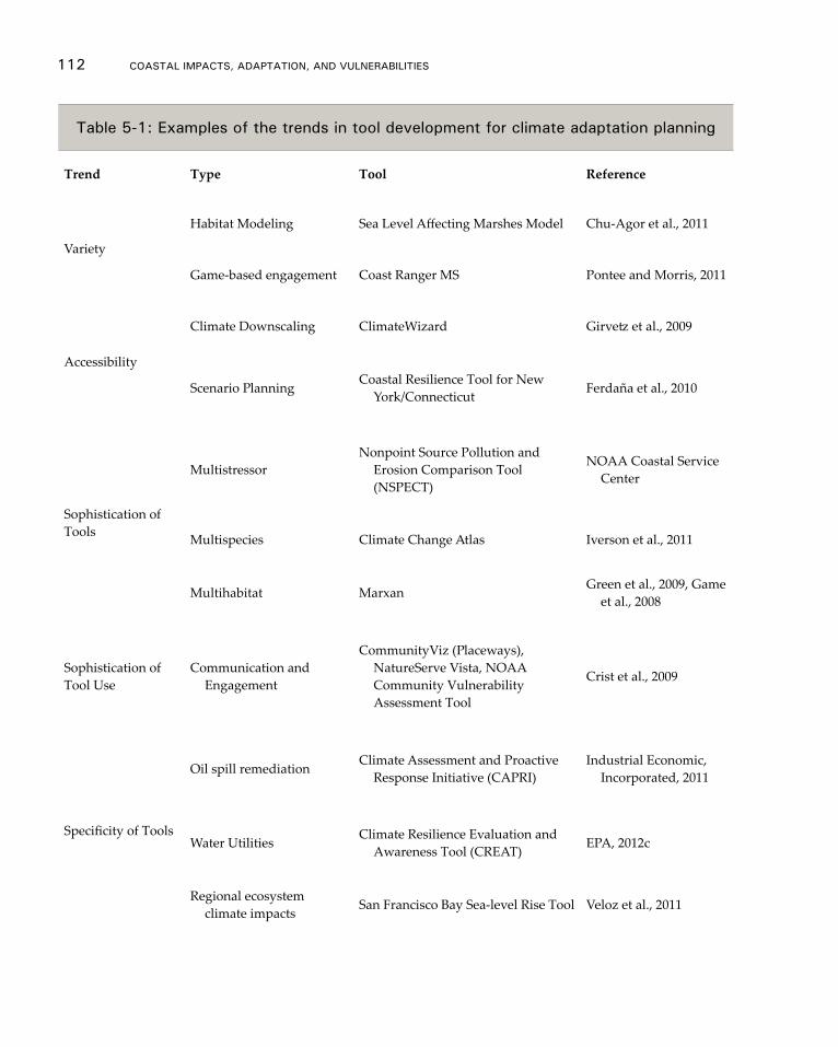
112 CoAsTAl ImpACTs, AdApTATIon, And VUlnerAbIlITIes
Table 5-1: examples of the trends in tool development for climate adaptation planning
Trend Type Tool Reference
Variety
Habitat Modeling Sea Level Affecting Marshes Model Chu-Agor et al., 2011
Game-based engagement Coast Ranger MS Pontee and Morris, 2011
Accessibility
Climate Downscaling ClimateWizard Girvetz et al., 2009
Scenario Planning Coastal Resilience Tool for New York/Connecticut Ferdaña et al., 2010
Sophistication of Tools
MultistressorNonpoint Source Pollution and
Erosion Comparison Tool (NSPECT)
NOAA Coastal Service Center
Multispecies Climate Change Atlas Iverson et al., 2011
Multihabitat Marxan Green et al., 2009, Game et al., 2008
Sophistication of Tool Use
Communication and Engagement
CommunityViz (Placeways), NatureServe Vista, NOAA Community Vulnerability Assessment Tool
Crist et al., 2009
Specificity of Tools
Oil spill remediation Climate Assessment and Proactive Response Initiative (CAPRI)
Industrial Economic, Incorporated, 2011
Water Utilities Climate Resilience Evaluation and Awareness Tool (CREAT) EPA, 2012c
Regional ecosystem climate impacts San Francisco Bay Sea-level Rise Tool Veloz et al., 2011
Adaptation and mitigation 113
al., 2011). Such systematic assessments will be essential to supporting informed tool se-lection by potential users (NRC, 2009).
Although specifics vary, most guidance on tool selection centers on roughly the same core idea: the importance of selecting tools based on an assessment of user goals, objec-tives, context, resources, and skills rather than trying to make management or research problems fit within the framework of a previously selected tool. Commonly expressed concerns are that users will select inappropriate tools based on what sounds impres-sive, seems easy, or has been used by others they know (for example, using a ranking tool when the management question is how to reduce the vulnerability of a particular species), or will seek or put too much emphasis on projections for species distribution changes or similar ecological shifts when data are insufficient to support such analyses. These problems clearly occur; what is unclear is how common they are and how much time is wasted, both of which could lead to poor decision-making. Further, no clear threshold has been established for when data or analyses are too limited or flawed to be valid; increasing guidance on how to decide when available data cannot support the de-sired tool or what caveats must be included with the outputs would be extremely useful.
Another commonly expressed concern relates to the need to provide support and guidance for decision making under conditions of uncertainty. Tools can be designed and used to facilitate and improve vulnerability assessment and adaptation planning re-gardless of gaps or flaws in the data (NRC, 2009). By using a variety of tools or running them multiple times with a range of different parameters such as sea-level-rise rates, exploring a range of plausible future scenarios is possible. Formal or informal sensitivity analyses can help to identify the variables with the largest uncertainty as well as those variable that have the greatest influence on the decisions at hand or, for purely scientific endeavors, the variables with the greatest influence on the system under consideration (Stralberg et al., 2011).
Policy and Regulatory Tools
Policy options for adapting to climate change include both a broad array of governmen-tal authorities and a range of possible pathways. The governmental activities include regulatory, taxation, planning, spending, and the general facilitation of private action (Grannis, 2011). The possible pathways include protecting existing land uses from the sea, which includes shoreline armoring; relocating human activities through retreat; and modifying human activities to enhance adaptive natural capacity of ecosystems by re-ducing stressors).
Governments are evaluating how to factor climate change into spending decisions to conserve public funds over the long-term and ensure that public assets such as road-ways and wastewater treatment facilities are resilient. Maryland’s plan recognizes that public investments in shore protection will be needed to protect critical facilities. Other states, such as California, are examining how they can direct funding to protect coastal resources to acquire vulnerable lands for conservation, to provide room for ecosystems to migrate inland to keep pace with sea-level rise, to provide a buffer for infrastructure, and to buy out vulnerable property owners.
Governments are also re-evaluating how they regulate coastal areas. Regulatory options include using zoning powers to require additional setbacks from shorelines,
114 CoAsTAl ImpACTs, AdApTATIon, And VUlnerAbIlITIes
density restrictions, clustered subdivisions, and building-size limits (NOAA, 2010). In Maryland, the state is instituting regulatory measures through its Living Shorelines Pro-tection Act to encourage landowners to use soft alternatives to shoreline armoring where feasible. Some authors have suggested the use of the “rolling easement” approach in which landowners are entitled to build and use their land as long as it remains dry but have no expectation of preventing the rising sea from reclaiming their land (Titus, 1998). Some states, such as Oregon, Texas, South Caroline, Rhode Island, Massachusetts, and Maine, have applied this approach in statutes or regulations. A recent federal report em-phasizes that rolling easements can also be implemented by the private sector through conservation easements or traditional property law arrangements (Titus, 2011). These reports acknowledge that the timing for implementing any regulatory approach will be critical; although coastal armoring is well understood and generally requires a lead time of a decade or less, nonstructural pathways, such as a gradual retreat from the coast, are less tested and may require a lead time of several decades.
Governments are also considering tax- and market-based incentives to promote dif-ferent pathways. Some examples include incentives such as conservation easements to encourage landowners to conserve vulnerable lands, density bonuses and transferrable development rights to develop sites upland, or tax rebates for homeowners who de-sign structures to exceed building code requirements by elevating structures to increase resiliency.
Several different approaches have been proposed for evaluating responses to employ and evaluating the tradeoffs. In choosing options, some of the issues that policymakers are weighing include: the relative economic costs and benefits of a particular responses; how protective the response is for the health, safety, and welfare of the community; and the environmental benefits or impacts of a response (NOAA, 2010). To be success-ful, chosen responses must also be administratively and legally feasible. Administra-tive challenges to this include budget and staffing constraints, and technical complexity (IPCC, 1990; NOAA, 2010); government actors also must have legal authority to imple-ment a response and responses must be consistent with existing laws and constitutions (Grannis, 2011).
5.4 Coastal Mitigation opportunities
The coastal zones of the U.S. have the potential to host many of our climate change mitigation efforts. This includes siting of non-greenhouse emitting energy generation through off-shore wind, tidal, and wave generation and ocean thermal conversion to displace or replace fossil fuel combustion methods of generation. Recent Department of Energy reports indicate that about one-third of the country’s annual electricity needs could be generated through wave and tidal current (EPRI, 2011; Haas et al., 2011). Addi-tionally, initial exploration of the concomitant carbon sequestration benefit may be real-ized when new resource management practices are employed in coastal habitats such as salt marshes, seagrasses, and mangroves.
Coastal Renewable Technologies
As the U.S. develops strategies to reduce greenhouse gas emissions and foster energy
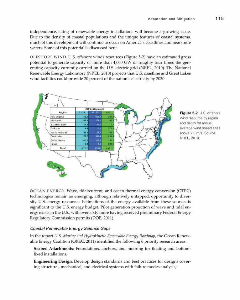
Adaptation and mitigation 115
independence, siting of renewable energy installations will become a growing issue. Due to the density of coastal populations and the unique features of coastal systems, much of this development will continue to occur on America’s coastlines and nearshore waters. Some of this potential is discussed here.
OFFSHORE WIND. U.S. offshore winds resources (Figure 5-2) have an estimated gross potential to generate capacity of more than 4,000 GW or roughly four times the gen-erating capacity currently carried on the U.S. electric grid (NREL, 2010). The National Renewable Energy Laboratory (NREL, 2010) projects that U.S. coastline and Great Lakes wind facilities could provide 20 percent of the nation’s electricity by 2030.
OCEAN ENERGY. Wave, tidal/current, and ocean thermal energy conversion (OTEC) technologies remain an emerging, although relatively untapped, opportunity to diver-sify U.S. energy resources. Estimations of the energy available from these sources is significant to the U.S. energy budget. Pilot generation projection of wave and tidal en-ergy exists in the U.S., with over sixty more having received preliminary Federal Energy Regulatory Commission permits (DOE, 2011).
Coastal Renewable Energy Science Gaps
In the report U.S. Marine and Hydrokinetic Renewable Energy Roadmap, the Ocean Renew-able Energy Coalition (OREC, 2011) identified the following 6 priority research areas:
Seabed Attachments: Foundations, anchors, and mooring for floating and bottom-fixed installations;
Engineering Design: Develop design standards and best practices for designs cover-ing structural, mechanical, and electrical systems with failure modes analysis;
Figure 5-2 U.S. offshore wind resource by region and depth for annual average wind speed sites above 7.0 m/s. Source: NREL, 2010.

116 CoAsTAl ImpACTs, AdApTATIon, And VUlnerAbIlITIes
Materials: Develop environmentally friendly protection coatings, biodegradable lubricants,and oils as well as advanced structural and foundation materials and char-acterize structural and fatigue properties;
Lifecycle and Manufacturing: Manufacturing processes for low-cost and high-vol-ume transportation and handling as well as rapid low-cost assembly and installation;
Power Takeoff and Control: Develop highly efficient power take-off systems with in-novative and adaptive control strategies to maximize energy capture and minimize damaging loads; and
Installation, Operations and Maintenance (O&M): Develop low-cost rapid instal-lation technologies for arrays, and methods to perform O&M during short weather windows.
Managing Living Coastal Resources for Carbon Capture
In addition to technology-based climate change mitigation efforts, the adoption of new resource management strategies (see section 5.3) for coastal and estuarine ecosystem services, including habitat protection and active restoration efforts, may also result in carbon sequestration.
Table 5-2: Total vs. recoverable wave energy in the U.s.
Total wave energy (TWh/yr)
Recoverable wave energy (TWh/yr)
Total 2,640 1170
West Coast 590 250
East Coast 240 160
Gulf of Mexico 80 60
Alaska 1570 620
Hawaii 130 80
Puerto Rico 30 20
Source: EPRI, 2011.
Adaptation and mitigation 117
The variety of ecosystem services and ecological, economic, and societal benefits of healthy coasts and estuaries are well-documented in a new report, Jobs and Dollars: Big Returns from Coastal Habitat Restoration (Restore America’s Estuaries, 2011). Our nation has lost more than half of its wetlands in the past 200 years (Dahl & Johnson, 1991), and the planet has lost a quarter of its salt marshes and freshwater tidal marshes and contin-ues to lose 1-2 percent per year, making these ecosystems some of the most threatened in the world (Convention on Biological Diversity, 2010). Moreover, between 2004 and 2009, the U.S. lost 110,000 acres of coastal wetlands (Dahl, 2011).
However, recent science has demonstrated that some of these same endangered coastal resources—coastal marshes, mangroves and sea grasses—may be able to seques-ter and store large quantities of carbon dioxide (CO
2) in plants and the soils below them
in a process termed blue carbon (Crooks et al., 2011). In the first meter of coastal wetland sediments alone, soil organic carbon averages 500 t CO
2e/ha (tonnes of carbon dioxide
equivalent per hectare) for sea grasses, 917 t CO2e/ha for salt marshes, 1060 t CO
2e/ha for
estuarine mangroves, and nearly 1800 t CO2e/ha for oceanic mangroves (Murray et al.,
2011). If destroyed, degraded, or lost, these coastal ecosystems become globally signifi-cant sources of carbon dioxide emitted into the atmosphere and the ocean. For example, in California’s Sacramento/San Joaquin Delta, drainage of 1,800 kilometers2
of wetlands
has released 0.9 giga tons, or billion tons, of carbon dioxide over the last century. An ad-ditional 5 to 7.5 million tons of CO
2 continue to be released on average from this Delta each year (Crooks et al., 2011). Additionally, the stresses of climate change, increasing temperature, sea-level rise, and acidification could challenge these ecosystems and lead to the release of this carbon.
In addition to the loss of carbon stores, when wetlands are degraded or destroyed, the ongoing sequestration capacity of wetlands is lost as well. Coastal wetlands seques-ter carbon at rates three to five times greater than global rates observed in mature tropi-cal forests: 6 to 8 t CO
2e/ha compared to 1.8–2.7 t CO
2e/ha (Murray et al., 2011). Although
the capacity of the systems to sequester carbon may be diminished when the systems are stressed by climate change. For example, when a coastal marsh is stressed due to rising salinities associated with sea-level rise, the capacity for the wetland to store carbon may diminish through time.
Protecting the remaining coastal wetlands in the U.S. and globally and restoring those that have been degraded or destroyed (McLeod et al., 2011) may provide meaningful contributions to climate change mitigation strategies. Carbon storage, when considered as an ecosystem service provided by coastal wetlands, could provide a strong incentive for protection and restoration through payments for blue carbon (Sifleet et al., 2011). However many of these ecosystems have been shown to release greenhouse gases under the conditions associated with climate change (Shindell et al., 2004; Vann & Megonigal, 2003), indicating that the permanence of coastal carbon must be carefully evaluated. Fur-thermore, oceans and coastal ecosystems have not been part of the policy dialogue for reducing greenhouse gases (Nellemann et al., 2009).
A key impediment to coastal conservation such as wetlands protection and resto-ration efforts is adequate assistance to undertake projects. In the U.S., the restoration community is well established but has a backlog of high-priority, shovel-ready proj-ects that amount to billions of dollars; for example, under the American Recovery and
118 CoAsTAl ImpACTs, AdApTATIon, And VUlnerAbIlITIes
Reinvestment Act of 2009, NOAA was provided $167 million for coastal habitat restora-tion but received project applications totaling more than $3 billion (NOAA press release, June 7, 2011).
Carbon Sequestration and Capture Science Gaps
The following recommendations were developed by the International Working Group on Coastal “Blue” Carbon (IWGCBC, 2011):10
• Develop inventory and accounting methodologies for coastal carbon to facilitate their inclusion in incentive agreements for conservation and effective manage-ment of coastal systems;
• Conduct carbon inventories in coastal areas identified as likely having high carbon storage and sequestration capacity. Include existing and at-risk potential areas of high carbon emissions;
• Conduct targeted research and monitoring to more accurately quantify the greenhouse gas emissions resulting from degradation, conversion, and destruc-tion of all relevant coastal ecosystems;
• Establish a network of field projects that demonstrate:
1. The capacity for carbon storage in coastal systems and the emissions resulting from degradation, conversion, and destruction of those systems; and
2. The feasibility of community monitoring approaches, management inter-vention, and incentives for maintaining carbon-rich systems;
• Conduct research quantifying the consequences of different coastal restoration and management approaches on carbon storage and emissions in coastal and nearshore marine ecosystems; and
• Develop standards and methods to translate remote sensing measurements into accurate estimates of carbon in coastal ecosystems, because remote sensing is currently the only method to efficiently map and monitor mangrove and tidal marshes at regional and global scales.
Additional gaps not mentioned in the IWGCBC report include:
• Assessing the effects of climate change on these coastal ecosystems, the potential efficacy of adaptation measures to ameliorate these effects, and the permanence of blue carbon due to the projected change;
• Evaluating the implications of coastal development plans on storage and permanence; and
• Understanding the carbon cycle and residence times in coastal habitats.
10 This working group was formed in 2011 by Conservation International (CI), the International Union for Conservation of Nature (IUCN), and the Intergovernmental Oceanic Commission (IOC) of UNESCO.

119
Chapter 6
Information gaps and Science needed to Support Sustainable Coasts
As discussed in the prior chapters, climate change is altering ecosystems on a global scale and impacting human welfare and health. The effects are highly varied and most pronounced along coasts. Furthermore, impacts to coastal regions are likely to be highly variable and accelerated in decades ahead. A key issue for coastal resource managers is to identify how, where, and when to adapt to the changes that will result from sea-level rise and changes in climate. These require cost-effective methods that benefit or minimize impacts to both the natural environment and human populations. Another im-portant issue is deciding how to fund such measures. To facilitate adaptation decisions, policy makers need credible scientific information. Predicting sea-level rise impacts such as shoreline change, wetland loss, and other ecosystem impacts with a high degree of confidence and precision is not possible at this time although the general scientific understanding of coastal response to climate change is well established.
Related effects of climate change, including changed storm regimes, temperature, precipitation, runoff, drought, and sediment supply add to the difficulty of providing place-specific, accurate, and reliable information. Lack of understanding of cumulative multi-stressor interactions in ecosystems and the mechanisms of thresholds shifts also inhibits predictions of future conditions. An integrated scientific program of sea level studies that seeks to learn from the historic and recent geologic past and monitors on-going physical and environmental changes will improve the level of knowledge and reduce the uncertainty about potential responses of coasts to sea-level rise and other drivers of coastal change. Outcomes of both natural- and social-scientific research will also support decision making and adaptive management for the coastal zone. The main elements of a potential science strategy and their interrelationships are shown in Figure 6-1, which was adapted from CCSP 4.1, Thieler et al., Chapter 14 (CCSP, 2009), followed by key research needs and tools for coastal adaptation planning that result from this as-sessment and/or are adapted from publications shown below.
Science research needs to Support Sustainable Coastal Management 11
• An assessment of the potential impacts of climate change on coastal and OCS energy development is confounded by a lack of baseline information,
11 (CCSP, 2009; Culver et al., 2010; NRC, 2010a,b; and resulting from this assessment and/or adapted from Moser et al. in review;)
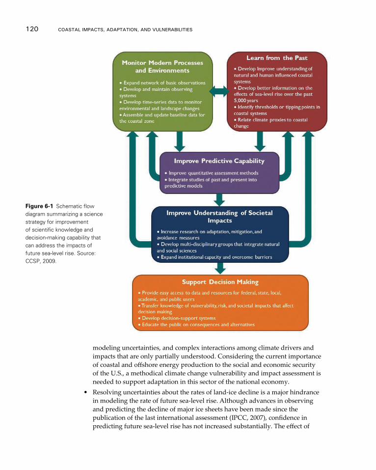
modeling uncertainties, and complex interactions among climate drivers and impacts that are only partially understood. Considering the current importance of coastal and offshore energy production to the social and economic security of the U.S., a methodical climate change vulnerability and impact assessment is needed to support adaptation in this sector of the national economy.
• Resolving uncertainties about the rates of land-ice decline is a major hindrance in modeling the rate of future sea-level rise. Although advances in observing and predicting the decline of major ice sheets have been made since the publication of the last international assessment (IPCC, 2007), confidence in predicting future sea-level rise has not increased substantially. The effect of
Figure 6-1 Schematic flow diagram summarizing a science strategy for improvement of scientific knowledge and decision-making capability that can address the impacts of future sea-level rise. Source: CCSP, 2009.
120 CoAsTAl ImpACTs, AdApTATIon, And VUlnerAbIlITIes
Information Gaps and science needed to support sustainable Coasts 121
this uncertainty is illustrated in the wide range of end points in the projected amount of sea-level rise through the end of this century (described in Chapter 2.3). Confidence in predictions of regional change in mean sea level is even lower, as are projections at decadal scales. Advancing our understanding of the drivers of sea-level change and moving beyond the semi-empirical approach presented in this report are research needs that are shared among all U.S. coastal communities and sectors of the coastal economy described in Chapter 4 of this report.
• Improved monitoring and collection of baseline data for coastal environments through linking networks of observing systems, developing time series data on environmental and landscape changes, and assembling fully accessible and searchable baseline data on coastal landforms, topography/bathymetry, animals, and plants for the coastal zone. This includes data on processes, tides, water level, waves, currents, precipitation, shoreline change, ocean circula-tion patterns, ocean chemistry, temperature, coastal processes, and sediment budgets.
• Improved understanding of ecosystems’ and species’ responses to basic envi-ronmental forces such as changes in temperature, precipitation, and chemistry of oceans and water bodies.
• Improved understanding of natural and human-influenced coastal systems through use of historic and geologic records of coastal change, increased knowledge of sea-level rise and coastal change over the past few millennia, identification of tipping points in coastal systems, and records that more closely relate past changes in climate to coastal change.
• Improvements in predictive capabilities of coastal change through improved quantitative assessment methods and integrating studies of the past and present into predictive models. Improved models are needed to assemble and process environmental data and aid in analysis as well as to make reliable projections of future conditions such as rates of sea-level rise and ice-sheet melting, changes in storm characteristics, and rates of shoreline retreat and wetland change.
• Improved place-based understanding of the societal drivers of vulnerability and impacts of sea-level rise and related coastal changes through improved data collection and integration, which must be followed up by communicating these findings to decision-makers. This includes generating consistent sea-level-rise scenarios and projections across federal agencies to support local planning and includes projection on the amount of sea-level rise within a region as well as on storm information and the general time frame within which these changes are anticipated.
• Research on adaptation, hazard risk reduction, and avoidance measures, including the cost, feasibility, side-effects, barriers, and acceptability, to support adaptation planning and decision making.
• Providing improved access to data, resources, and integrated assessments for decision makers, thus facilitating the transfer of knowledge about risks,

122 CoAsTAl ImpACTs, AdApTATIon, And VUlnerAbIlITIes
vulnerabilities, and adaptation choices, and educating the public about conse-quences and alternatives.
• Improved coastal vulnerability assessments, including human infrastructure and ecosystems, by including all coastal regions and incorporating multiple factors such as population, land use, critical infrastructure, natural resources, economic information, social vulnerability and other community characteristics so that potential outcomes can be examined in a holistic framework of environ-mental, social, economic, and other non-climate factors that influence overall exposure and adaptive capacity.
• Research on the scientific understanding of cumulative multi-stressor interac-tions and threshold shifts in ecosystems. This includes methods to identify the triggers of threshold responses and to anticipate the likely trajectory of post-threshold states under a range of future scenarios of climate and land-use change.
• Improved long-term, homogeneous, observational datasets and geologic proxy records for monitoring and measuring climate changes. The science of under-standing climate change and being able to make reliable projections of future conditions will benefit from an array of linked observations and monitoring of basic factors such as temperature, rainfall, ocean circulation, waves and currents, ocean chemistry, sea level elevation, shoreline change, storm charac-teristics, and changes to glaciers and ice sheets. Maintaining an array of satellite systems for observations is critical.
• Developing advanced statistical analysis techniques for examining observations and models of the climate system and for rigorously comparing observations with models results.
• Improving the integration of existing long-term climate, ocean, and ecosystem observations with human-health surveillance is necessary to predict and reduce human-health risks related to climate change in coastal areas.
• Providing collaboration teams of researchers and practitioners across multiple disciplines including oceanography, climate, biology, and public health are critical to develop and apply useful decision-support tools that reduce public-health risks.
• Improving legal frameworks and administrative structure and tools as well as data on zoning, permitting regimes, legislative restrictions, etc.
Science-Based Tools Needed for Coastal Management and Adaptation Planning
The tools necessary for adaptation planning are difficult to prioritize because they will depend upon the community needs as well as where each community is in the planning process. Adaptation tools need to be understood in terms of input data requirements, assumptions of the method, and the reliability and utility of the outputs. A suite of tools that work together to support planning and decision making is described below.
COMMUNICATION TOOLS. The tools that can facilitate coastal stakeholder engage-ment, visioning, and consensus building include:
Information Gaps and science needed to support sustainable Coasts 123
• Definitions to establish a common language to discuss climate impacts and adaptation strategies;
• Tools to educate the public on the science, impacts, probability, and risk;• Guidance and best practices for the planning process; and• Tools for facilitation and conflict management.
MONITORING AND MODELING TOOLS. Tools for monitoring and modeling current and future environmental conditions include:
• Estimates of sea-level rise that are useful at regional and local levels for compa-rability across jurisdictional boundaries;
• Standards and data architecture to integrate existing databases of observations of water levels and other relevant data;
• Advanced models to improve scientific understanding and allow for better quantification of uncertainities:
− Storm surge models with wave measurements; − Advanced climate and earth-system models; − Improved estimates of past and projected future climate-forcing agents; − Geomorphic models; − Geospatial models for sea-level rise; − Flooding/inundation models; − Habitat models; − Long-term erosion and accretion models; and − El Niño Southern Oscillation/climatological impact projections.
• Downscaling techniques for these models for use in regional or smaller scale scenarios.
VISUALIZATION AND SCENARIO-BUILDING TOOLS. The tools that would help communities identify and explore alternative adaptation solutions include:
• Visualizations using familiar viewers such as Google Earth for different sea-level rise, storm frequency, and inundation scenarios that are interactive, offer planar and oblique views, and show critical infrastructure, relevant landmarks, and other information that allows communities to understand impacts;
• Definitions and analysis of economic impacts and loss;• Conversions of vulnerability into risk information;• Assessments of economic, social, and physical risk; • Valuations of ecosystem services in monetary and nonmonetary terms; and• Scenario evaluations that:
− Identify key assumptions; − Test alternative outcomes;
124 CoAsTAl ImpACTs, AdApTATIon, And VUlnerAbIlITIes
− Identify signposts and thresholds based on monitoring data; and − Evaluate policy tradeoffs based on key unknowns.
IMPLEMENTATION TOOLS. Tools useful to build institutional capacity and imple-ment adaptation include:
• Long-term policy analysis tools to help choose among options;• Database of case studies and best practices that can be queried;• Resources such as a clearinghouse or points of contact to understand agency
activities and potential funding sources;• Evaluation tools to assess the effectiveness of adaptation strategies;• Operational tools that address current conditions and short-term risk;• Engineering tools for coastal protection, relocation, and restoration; and• Evaluation tools to assess the effectiveness of implementation of adaptation
strategies.
Future Research – Local vs. Regional Studies, Infrastructure, Monitoring, and Co-Benefits
The research on coastal vulnerability includes some regional studies using comparable indicators and methods and an array of locally-oriented case studies. Although these two approaches provide valuable information about social vulnerability, an important research gap remains regarding their ability to inform decision making about risk-based adaptation. The local case studies generally engage the more specific issues within a community but fail to offer comparability across larger areas (Frazier et al., 2010b; Noss, 2011; Tang et al., 2011). The regional approaches provide that comparability by relying on commonly collected indicators such as demographics, but they are simultaneously limited in the types of locally-specific considerations they are able to incorporate consis-tently. Addressing the need for comparability and specificity to inform adaptation deci-sion making at local, regional, and national scales is a key challenge in this area.
A robust coastal monitoring, surveillance, and observation system that integrates physical, biological, and key social parameters, and delivers early warning and predic-tive information, will also be critical to better prepare for changes in climate across time scales. A sustained integrated system establishes baseline information, which is sorely needed to understand the impact of climate and to provide trustworthy guidance to coastal populations following natural disasters and other climate-related changes (Jo-chens, 2010).
125
appendix a
Chesapeake Bay Case Study
1: Introduction
The Chesapeake Bay (the Bay) is located in the Mid-Atlantic and is the largest estuary in the U.S. The watershed is approximately 64,000 square miles and covers parts of the District of Columbia and six states: New York, Pennsylvania, Delaware, Maryland, West Virginia, and Virginia . About 17 million people live in the watershed, with approxi-mately 10 million people along or near the shores.
Since the 1600s, land cover in the Bay has changed significantly due to develop-ment, with 1.7 million acres of the Bay watershed developed between 1600 and 1950 and
Table of Contents
1: InTrodUCTIon
2: ClImATe CHAnGe ImpACTs on WATer QUAlITy And eQUATIC eCosysTems For THe CHesApeAKe bAy
2.1 Changes in Physical Climate 2.2 Impacts on Biochemistry and Water Quality 2.3 Impacts on Ecosystems
3: ClImATe CHAnGe sCenArIos For THe CHesApeAKe bAy
4: oVerVIeW oF sTATe leVel AdApTATIon plAnnInG And ImplemenTATIon ACross THe CHesApeAKe bAy
4.1 Maryland4.2 Pennsylvania4.3 Virginia
5: reFerenCes
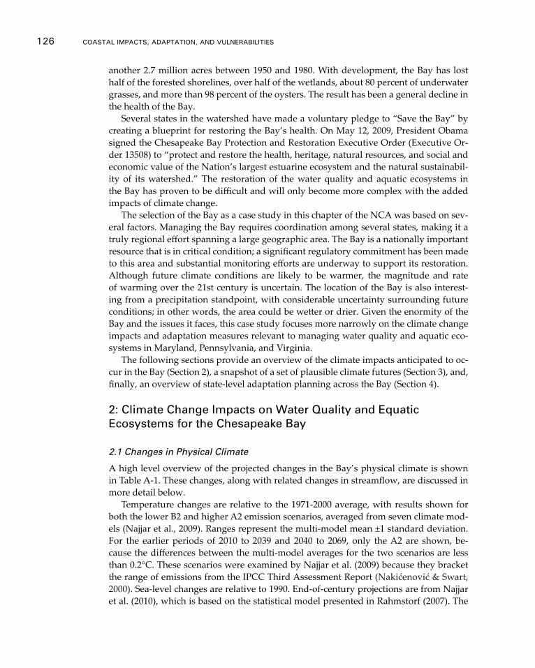
another 2.7 million acres between 1950 and 1980. With development, the Bay has lost half of the forested shorelines, over half of the wetlands, about 80 percent of underwater grasses, and more than 98 percent of the oysters. The result has been a general decline in the health of the Bay.
Several states in the watershed have made a voluntary pledge to “Save the Bay” by creating a blueprint for restoring the Bay’s health. On May 12, 2009, President Obama signed the Chesapeake Bay Protection and Restoration Executive Order (Executive Or-der 13508) to “protect and restore the health, heritage, natural resources, and social and economic value of the Nation’s largest estuarine ecosystem and the natural sustainabil-ity of its watershed.” The restoration of the water quality and aquatic ecosystems in the Bay has proven to be difficult and will only become more complex with the added impacts of climate change.
The selection of the Bay as a case study in this chapter of the NCA was based on sev-eral factors. Managing the Bay requires coordination among several states, making it a truly regional effort spanning a large geographic area. The Bay is a nationally important resource that is in critical condition; a significant regulatory commitment has been made to this area and substantial monitoring efforts are underway to support its restoration. Although future climate conditions are likely to be warmer, the magnitude and rate of warming over the 21st century is uncertain. The location of the Bay is also interest-ing from a precipitation standpoint, with considerable uncertainty surrounding future conditions; in other words, the area could be wetter or drier. Given the enormity of the Bay and the issues it faces, this case study focuses more narrowly on the climate change impacts and adaptation measures relevant to managing water quality and aquatic eco-systems in Maryland, Pennsylvania, and Virginia.
The following sections provide an overview of the climate impacts anticipated to oc-cur in the Bay (Section 2), a snapshot of a set of plausible climate futures (Section 3), and, finally, an overview of state-level adaptation planning across the Bay (Section 4).
2: Climate Change Impacts on Water Quality and equatic ecosystems for the Chesapeake Bay
2.1 Changes in Physical Climate
A high level overview of the projected changes in the Bay’s physical climate is shown in Table A-1. These changes, along with related changes in streamflow, are discussed in more detail below.
Temperature changes are relative to the 1971-2000 average, with results shown for both the lower B2 and higher A2 emission scenarios, averaged from seven climate mod-els (Najjar et al., 2009). Ranges represent the multi-model mean ±1 standard deviation. For the earlier periods of 2010 to 2039 and 2040 to 2069, only the A2 are shown, be-cause the differences between the multi-model averages for the two scenarios are less than 0.2°C. These scenarios were examined by Najjar et al. (2009) because they bracket the range of emissions from the IPCC Third Assessment Report (Nakićenović & Swart, 2000). Sea-level changes are relative to 1990. End-of-century projections are from Najjar et al. (2010), which is based on the statistical model presented in Rahmstorf (2007). The
126 CoAsTAl ImpACTs, AdApTATIon, And VUlnerAbIlITIes

Chesapeake bay Case study 127
range in sea-level rise primarily reflects the range in warming projected by various emis-sion scenarios. Uncertainty language in Table A-1 is taken from Najjar et al. (2010); “very likely” corresponds to changes with 90-99% likelihood.
TEMPERATURE. Temperatures in the Bay are likely to increase throughout the 21st century (Table A-1). The range of projected temperature changes reflects both differ-ences in projected warming across climate models in response to a single greenhouse gas emissions scenario and differences due to multiple emissions scenarios. The latter is a particularly important driver of the relatively large range in the projections for the end of the 21st century.
Although specific projections for water temperatures in Chesapeake Bay are not cur-rently available, regional atmospheric temperatures are well correlated to water temper-atures; therefore, increases in water temperature are also expected (Najjar et al., 2010).
In addition to changes in mean temperature, the frequency and intensity of extreme heat events are likely to increase. Heat waves, defined as the longest period in the year of at least five consecutive days with maximum temperature at least 5°C higher than the climatology of the same calendar day, are projected to increase along the east coast of North America, including the mid-Atlantic, by more than two standard deviations by 2100 under the A1B emissions scenario (Meehl et al., 2007).
Table A-1: projected changes in the bay’s temperature, precipitation, and sea level
ImpactProjected short-term change (2010-2039)
Projected medium- term change (2040-2069)
Projected long- term change (2070-2099)
Remarks about Uncertainty
Temperature +0.9°C to +1.5°C +1.7°C to +3.7°C+2.7°C to +6.7°C (A2) +2.1°C to 4.9°C (B2) Very likely; warming simulated
for all models in all future periods
Annual Precipitation -1% to +3% -5% to -9% -9% to +15% (A2)
-4% to +10% (B2)
Although annual precipitation projections from single models include both increases and decreases, the consensus of models calls for increases in the winter and spring
Sea-level rise Not available for Chesapeake Bay
Not available for Chesapeake Bay
700-1600 mm(global+local subsidence, by 2100)
Very likely; projection includes Chesapeake Bay subsidence (estimated at 2 mm/yr)
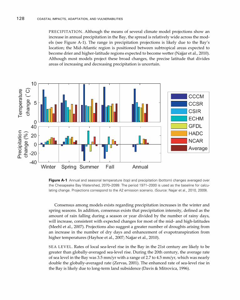
128 CoAsTAl ImpACTs, AdApTATIon, And VUlnerAbIlITIes
PRECIPITATION. Although the means of several climate model projections show an increase in annual precipitation in the Bay, the spread is relatively wide across the mod-els (see Figure A-1). The range in precipitation projections is likely due to the Bay’s location; the Mid-Atlantic region is positioned between subtropical areas expected to become drier and higher-latitude regions expected to become wetter (Najjar et al., 2010). Although most models project these broad changes, the precise latitude that divides areas of increasing and decreasing precipitation is uncertain.
Consensus among models exists regarding precipitation increases in the winter and spring seasons. In addition, consensus exists that precipitation intensity, defined as the amount of rain falling during a season or year divided by the number of rainy days, will increase, consistent with expected changes for most of the mid- and high-latitudes (Meehl et al., 2007). Projections also suggest a greater number of droughts arising from an increase in the number of dry days and enhancement of evapotranspiration from higher temperatures (Hayhoe et al., 2007; Najjar et al., 2010).
SEA LEVEL. Rates of local sea-level rise in the Bay in the 21st century are likely to be greater than globally-averaged sea-level rise. During the 20th century, the average rate of sea level in the Bay was 3.5 mm/yr with a range of 2.7 to 4.5 mm/yr, which was nearly double the globally-averaged rate (Zervas, 2001). The enhanced rate of sea-level rise in the Bay is likely due to long-term land subsidence (Davis & Mitrovica, 1996).
Figure A-1 Annual and seasonal temperature (top) and precipitation (bottom) changes averaged over the Chesapeake Bay Watershed, 2070–2099. The period 1971–2000 is used as the baseline for calcu-lating change. Projections correspond to the A2 emission scenario. (Source: Najjar et al., 2010, 2009).
Chesapeake bay Case study 129
Table A-1 presents sea-level-rise estimates for the Bay for the end of the 21st century. The estimates of 700 to 1600 mm are based on the statistical model presented in Rahm-storf (2007), which equates the rate of sea-level rise to the amount of warming occurring since the late 20th century. It also includes consideration of land subsidence around the Bay of 2 mm/yr (Najjar et al., 2010). The relatively large range in the sea-level estimates reflects the uncertainty in the magnitude of warming occurring by 2100, which stems from the use of different emission scenarios.
STREAMFLOW. Projections for streamflow span a wide range from decreases of 40 per-cent to increases of 30 percent associated with a doubling of the concentration of carbon dioxide (Najjar et al., 2010; Najjar et al., 2009). In part, this range reflects uncertainty in projections of precipitation, which is the primary driver of interannual variability of streamflow; however, it also reflects the large uncertainty in modeling the evapotranspi-ration response associated with higher temperatures, especially for scenarios involving substantial temperature change (Najjar et al., 2010).
The seasonality of streamflow across the Northeast is likely to change, with higher flows projected for the winter, earlier peak flows projected for the spring, and reduced flows projected for the summer (Hayhoe et al., 2007). These changes arise from increased winter rainfall, a shift to a greater proportion of precipitation as rain rather than snow in the winter, earlier snow melt in the spring, less groundwater recharge in the spring, and increased evapotranspiration across the seasons (Hayhoe et al., 2007). Najjar at al. (2010) indicate that such a shift in peak streamflow might occur in the Bay, but such temporal shifts have not been detected in the Chesapeake system and the role of snowmelt may only be important for watersheds farther north of the Chesapeake (Murphy et al., 2011).
2.2 Impacts on Biogeochemistry and Water Quality
NUTRIENTS. Nitrogen and phosphorus are important components of the biogeo-chemical processes in the Bay. Although these nutrients are important for aquatic life, additions of these nutrients from non-point sources, especially those associated with anthropogenic activities such as agriculture and runoff from impervious surfaces, repre-sent a challenge to maintaining water quality. Temperature and precipitation can affect the timing and amount of nutrients introduced to and transported through the Bay, giv-ing climate a potentially important role in affecting the Bay’s biogeochemical cycles and water quality.
Nutrient inputs to the Chesapeake Bay come from several pathways, each of which can be affected by climate differently.
Nitrogen export from watersheds. Overall, the average nitrogen export flux to the Bay is 20-25% of the total anthropogenic inputs that occur within the watershed. Watersheds that include agricultural operations and developed suburban and urban areas tend to export more nitrogen than forested areas in the Bay (Kaushal et al., 2008). Streamflow acts as an important modulator of export; lower rates of export have been observed dur-ing dry years such as 2002 because nutrient residence times are increased (Kaushal et al., 2008). Conversely, higher flows, even those associated with individual weather events, can increase export. In 2003, heavy rainfall and high flows associated with Hurricane
130 CoAsTAl ImpACTs, AdApTATIon, And VUlnerAbIlITIes
Isabel led to relatively high export rates (Kaushal et al., 2008). Temperature can also affect export because higher temperatures enhance rates of denitrification and lower ex-port (Najjar et al., 2010).
The effects of future climate change on nitrogen export are somewhat uncertain be-cause of the important role that streamflow plays. One study projects an increase in nitrogen flux down the Susquehanna River of 17 percent by 2030 and 65 percent by 2095 with associated increases in precipitation of 4 percent and 15 percent, respectively (How-arth et al., 2006). Another study shows a decrease in nitrogen flux down the Susque-hanna River by 20 percent with a projected increase in temperature of 3°C (Schaefer and Alber, 2007). However, a study for the Patuxent River suggests that the sensitivity of nitrogen export to changes in precipitation and temperature could be much smaller; a 5 percent increase in precipitation would be accompanied by only a 5 percent increase in export while a 1°C warming was estimated to reduce export by only 3 percent (Johnson & Kittle, 2007). Improving projections would require an improved representation of the processes that control nitrogen exports in models (Najjar et al., 2010)
Nitrogen deposition. Atmospheric deposition of nitrogen occurs both directly on the Bay and onto land within the watershed. The amount of nitrogen deposited into the Bay is poorly known, with estimates ranging from 14 percent to 64 percent of the total nitrogen load in the Bay (Najjar et al., 2010). Although projecting how deposition could change in the future may be difficult, deposition is certainly sensitive to changes in pre-cipitation and wind patterns. Also, climate’s effect on the types of tree species found in the region’s forests could have implications for overall nitrogen cycling (Najjar et al., 2010); for example, if forests shift toward more maple species and fewer oak species as projected, (Najjar et al., 2010; Iverson et al., 2005), nitrate production in soils could be enhanced.
Phosphorous and sediment loading. Unlike many other biogeochemical cycles, the at-mosphere does not play a significant direct role in the movement of phosphorus. Phos-phorus from non-point sources is mainly controlled by the rate of erosion. Increases in precipitation and streamflow could lead to enhanced sediment loading and increased phosphorous levels because sediment loading is a non-linear function of streamflow. However, little has been done to test how climate change will affect erosion rates (Najjar et al., 2010).
DISSOLVED OXYGEN. Reductions in oxygen availability can stress aquatic ecosys-tems. Nutrient levels, as well as physical climate (the two of which are themselves re-lated), can make the Bay more or less prone to hypoxic or anoxic events in several ways.
Nutrient loads. In general, waters with high nutrient levels can experience eutrophica-tion, which can deplete dissolved oxygen. Policies including a ban on phosphate-based detergents and the use of nitrogen removal systems in wastewater treatment plants have facilitated the reduction of nutrient loading over the last several decades in some por-tions of the Bay (Kemp et al., 2009; Ruhl et al., 2010; Williams et al., 2010), but trends in hypoxia and other measures of water quality have not necessarily shown much im-provement. Murphy et al. (2011) suggest that significant increases observed in early
Chesapeake bay Case study 131
summer hypoxia may reflect climate-driven changes in stratification (see below) while slight decreases during late summer hypoxia may reflect reductions in nutrient loading.
Temperature and oxygen solubility. Warmer temperatures decrease the solubility of oxy-gen in water. During summertime conditions, oxygen saturation below the pycnocline is sensitive to warming, with saturation concentrations dropping -0.16 mg/L for each degree of warming. Thus, for 5°C of warming, waters that might be severely hypoxic (<1 mg/L) now would be anoxic (<0.2 mg/L) (Najjar et al., 2010).
Stratification. Stratification restricts water column mixing and results in a lower con-centration of oxygen in bottom water (Murphy et al., 2011). Late spring and summer stratification is well correlated with late winter and early spring streamflow; increases in streamflow would likely lead to enhanced stratification (Najjar et al., 2010). Stratification is also considered to be sensitive to atmospheric circulation (Scully, 2010; Kemp et al., 2009) and the flux of salt (Kemp et al., 2009) into the Bay. Thus, changes in streamflow, summertime wind patterns, and sea-level rise could all potentially alter the frequency and severity of stratification.
ACIDIFICATION. Increases in atmospheric concentrations of carbon dioxide have led to decreases in pH and carbonate ion concentration. Globally, the surface ocean’s pH is estimated to have been reduced by 0.1 units (~30% more acidic) (Orr et al., 2005).
Within the Bay, pH can be affected by a variety of factors in addition to atmospheric carbon dioxide concentration, including eutrophication, chemical characteristics of in-put waters, and deposition of acid-forming compounds like sulfur and nitrogen (Wald-busser et al., 2009). Although statistically significant decreases in pH over the last several decades have been measured in some polyhaline waters of the Bay, mesohaline waters that have been sampled have shown either little change or increases in pH (Waldbusser et al., 2009)
2.3 Impacts on Ecosystems
HARMFUL ALGAL BLOOMS. Harmful algal blooms are a recognized threat to Ches-apeake Bay ecosystems (Anderson et al., 2010) and can constitute a threat to human health (Najjar et al., 2010). Links between nutrient concentrations and some species of harmful algae have been documented (Anderson et al., 2010), making blooms poten-tially sensitive to changes in regional precipitation and streamflow that could affect nu-trient loads, as discussed above. Recently observed blooms provide evidence for this sensitivity; for example, the bloom of Dinophysis acuminate in 2002 followed a period of drought, which permitted the introduction of harmful oceanic species of algae to the Bay (Marshall et al., 2004). Also, heavy rainfall following periods of drought elevated nutri-ent levels contributed to harmful algal blooms in 2007 (Mulholland et al., 2009).
Other forms of atmospheric and climate change could favor future harmful aglal blooms. Increases in concentrations of carbon dioxide may enhance the growth of bloom-forming dinoflagellates (Najjar et al., 2010). Increases in temperature, along with a shift to more stratified conditions, has been observed to increase the growth of several species of algae (Najjar et al., 2010; Peperzak 2003), but Anderson et al. (2010) show a
132 CoAsTAl ImpACTs, AdApTATIon, And VUlnerAbIlITIes
negative relationship between temperature and algal blooms for Pseudo-nitzschia, which is capable of producing the toxic domoic acid that poisons shellfish and causes neuro-logical damage in humans.
SUBMERGED AQUATIC VEGETATION. Submerged aquatic vegetation (SAV) serves important functions in the Bay, providing habitats for many aquatic organisms, taking up nutrients, and stabilizing sediments. SAV in the Bay is composed of numerous differ-ent plant species with variable tolerances for temperature, salinity, and other environ-mental conditions.
Climate can affect SAV directly, and through its influence on the Bay’s biogeochemis-try, SAV can be detrimentally affected by high temperatures. In 2005, significant die-off of Zostera marina occurred following a period of high summer temperatures (Orth et al., 2010). SAV growth can also be retarded by high concentrations of suspended sediments or by growth of microorganisms that block sunlight. As a result, increases in rainfall and streamflow that raise sediment and nutrient levels can reduce water clarity and SAV abundance (Najjar et al., 2010).
Salinity gradients within the Bay already influence the types of SAV species that grow in different regions, with more salt-tolerant species found in the lower reaches of the Bay. Changes in salinity due to sea-level rise or changes in precipitation could alter the distribution of species (Najjar at al., 2010). Similarly, increases in carbon dioxide may favor growth in some species of SAV provided sufficient light is available, which would also contribute to changes in species distributions (Najjar et al., 2010).
ESTUARINE WETLANDS. The consequences of sea-level rise for wetlands are highly uncertain. The extent to which accretion and migration of wetlands, which would act to maintain or increase their acreage, will be offset by inundation of existing wetlands is unclear (Najjar et al., 2010). Observations of vegetative changes suggest that loss may be favored (Najjar et al., 2010; Perry & Hershner, 1999), although increases in carbon dioxide and temperature could assist the growth of marsh vegetation and enhance wet-land accretion (Najjar et al., 2010). Regardless of changes in acreage, more frequent in-undation may alter species composition and favor the proliferation of invasive species such as Phragmites australis (Najjar et al., 2010; U.S. EPA, 2008). Overall, changes for wetlands will be strongly influenced by changes in human land use; development and shoreline hardening can inhibit wetland migration (Najjar et al., 2010).
FISH. Climate change is likely to alter the distribution and abundances of the Bay’s vari-ous fish species. For fish that are tolerant of warmer temperatures or are vulnerable to particularly cold winters, warming could extend the length of the growing season and act as a benefit (Najjar et al., 2010), but warming could contract the geographic range of cold-temperature fish. Warming is also likely to have numerous indirect effects on fish; for example, changes in habitat as well as the timing and availability of prey and preda-tors could lead to shifts in species composition in the Bay. Recent observations show that some fish pathogens have been more successful at surviving over the winter; if warming continues this trend, then fish illness and mortality may increase (Najjar et al., 2010).
Like warming, changes in salinity could also have impacts on the distribution and relative abundance of prey and predators. Najjar et al. (2010) note that sea nettles
Chesapeake bay Case study 133
(Chrysaora quinquecirrha) could benefit from increases in salinity, which could have im-portant implications for the survival of fish eggs and larva as well as the composition of zooplankton communities that serve as food for many aquatic species.
Hypoxic conditions present serious threats to fish. Combined with warming, which can raise fishes’ metabolic rates, low-dissolved oxygen levels can inhibit growth (Hanks & Secor, 2010) and lead to mortality.
SHELLFISH. Warming may benefit some species of shellfish. Fewer cold winters could reduce mortality of blue crabs (Callinectes sapidus, Hines et al., 2010) and less frequent freezing of shoreline habitats could assist oysters as they form reefs (Najjar et al., 2010). Warming could also allow blue crabs to increase reproduction by increasing the num-ber of broods per season (Hines et al., 2010), but warming and changes in salinity are likely to have many indirect effects on shellfish through changes in habitat as well as the prevalence of pathogens and the timing and distribution of food and predators.
Specifically for shellfish, acidification of Bay waters could alter their ability to form shells. The calcification process is significantly inhibited by reductions in pH, which could lead to slower shell formation rates or weaker shells (Waldbusser et al., 2009). However, experiments with the Eastern Oyster (Crassostrea virginica) show that increas-es in temperature and high levels of salinity can help minimize the impacts of lowering pH on calcification (Waldbusser et al., 2009).
3. Climate Change Scenarios for the Chesapeake Bay
The available information on anticipated climate change impacts (summarized above) can be used to develop a broad set of plausible futures or scenarios to facilitate consider-ation of adaptation options. The information presented below (see Table A-2) provides a snapshot of climate drivers, plausible directions, and potential impacts of concern across the Bay. It draws from projected conditions for the end of the 21st century to present information describing likely changes from model projections that appear to converge, which provides greater confidence, and uncertain changes from model projections that diverge, which provides lower confidence.
4. overview of State-level Adaptation Planning and Implementation Across the Chesapeake Bay
The states in the Chesapeake Bay watershed are working together to help to improve the water quality and health of aquatic ecosystems in the Bay. As of February 2012, Mary-land and Pennsylvania have prepared state-wide adaptation plans that consider a range of climate change impacts and Delaware has released a plan to address sea-level rise in the state. The District of Columbia, New York, and Virginia have each published climate action plans, which include adaptation recommendations as part of a larger approach primarily focused on climate change mitigation by reducing greenhouse gas emissions. All of the adaptation plans developed to date offer recommendations rather than man-dates intended to inform practitioners and law-makers at both the state and local levels on how to adapt.
This section provides a description of the adaptation activities in Maryland,

134 CoAsTAl ImpACTs, AdApTATIon, And VUlnerAbIlITIes
Table A-2: Climate drivers, plausible directions, and potential impacts of concern across the bay
Climate Drivers Plausible Directions Why this Matters/ Potential
Impacts Sources
Precipitation Drier – Small decreases in annual precipitation (<5%), with larger decreases in summer and fall precipitation (>10%), and longer periods of time without rain
Wetter – Up to a 20% increase in annual precipitation; 10-20% increases in winter and spring precipitation
More intense heavy rainfall events – Strong winter storm events could dump more rain (not mutually exclusive with either wetter/drier scenarios)
Projections for precipitation for the region are highly uncertain, including both increases and decreases.
Scenarios will likely need to involve some estimate of both drier and wetter conditions.
Precipitation is an important driver of streamflow, changes for which have broad impacts on water quality and ecosystems.
Drier/Wetter: Qualitative examination of the range of models for the A2 scenario, 2070-2099 (Najjar et al. 2010, Fig. 4; reproduced as Fig. 1 above)
Intensity: Najjar et al., 2010; discussing Lambert and Fyfe (2006)
Temperature Warmer – temperatures moderately increase (e.g., 2° C), with fewer extreme cold days and more heat waves
Warmest – temperatures increase more significantly (e.g., 5° C), with many more extreme hot weather events
Warming can directly impact the species composition of the Bay. Temperature-induced changes in evaporation change could interact with changes in precipitation to have a significant impact on regional hydrology. Although temperatures are likely to increase, the magnitude of warming is uncertain.
Najjar et al. 2009 – many values of warming could be chosen. Warming of 2.3°C corresponds to the one standard deviation below the average of the four “best” models for the Chesapeake Bay for the B2 scenarios for 2070-2099. Warming of 5°C represents one standard deviation above the same multi-model average for the A2 scenario.
Sea-level rise (SLR)
Moderate acceleration in sea-level rise – 700 millimeters by 2100.
Higher acceleration in sea-level rise – 1600 millimeters by 2100.
Sea-level rise is anticipated to accelerate in the 21st century. Rates of observed sea-level rise in the Bay have been greater than global averages due to land subsidence. Sea-level Rise has implications for habitat inundation and salinity.
Najjar et al., 2010; application of Rahmstorf (2007) estimates for global sea-level rise to local rates of subsidence
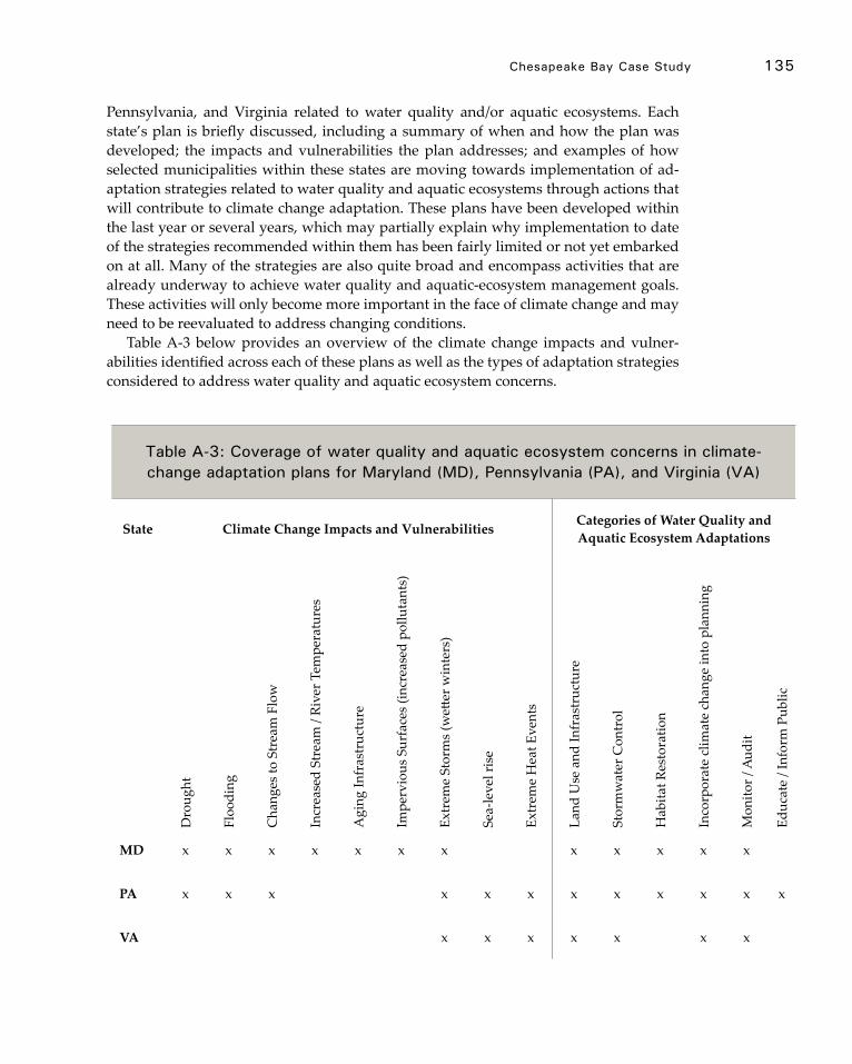
Chesapeake bay Case study 135
Pennsylvania, and Virginia related to water quality and/or aquatic ecosystems. Each state’s plan is briefly discussed, including a summary of when and how the plan was developed; the impacts and vulnerabilities the plan addresses; and examples of how selected municipalities within these states are moving towards implementation of ad-aptation strategies related to water quality and aquatic ecosystems through actions that will contribute to climate change adaptation. These plans have been developed within the last year or several years, which may partially explain why implementation to date of the strategies recommended within them has been fairly limited or not yet embarked on at all. Many of the strategies are also quite broad and encompass activities that are already underway to achieve water quality and aquatic-ecosystem management goals. These activities will only become more important in the face of climate change and may need to be reevaluated to address changing conditions.
Table A-3 below provides an overview of the climate change impacts and vulner-abilities identified across each of these plans as well as the types of adaptation strategies considered to address water quality and aquatic ecosystem concerns.
Table A-3: Coverage of water quality and aquatic ecosystem concerns in climate-change adaptation plans for maryland (md), pennsylvania (pA), and Virginia (VA)
State Climate Change Impacts and Vulnerabilities Categories of Water Quality and Aquatic Ecosystem Adaptations
Dro
ught
Floo
ding
Cha
nges
to S
trea
m F
low
Incr
ease
d St
ream
/ Ri
ver T
empe
ratu
res
Agi
ng In
fras
truc
ture
Impe
rvio
us S
urfa
ces
(incr
ease
d po
lluta
nts)
Extr
eme
Stor
ms
(wett
er w
inte
rs)
Sea-
leve
l ris
e
Extr
eme
Hea
t Eve
nts
Land
Use
and
Infr
astr
uctu
re
Stor
mw
ater
Con
trol
Hab
itat R
esto
ratio
n
Inco
rpor
ate
clim
ate
chan
ge in
to p
lann
ing
Mon
itor /
Aud
it
Educ
ate
/ Inf
orm
Pub
lic
MD x x x x x x x x x x x x
PA x x x x x x x x x x x x
VA x x x x x x x

136 CoAsTAl ImpACTs, AdApTATIon, And VUlnerAbIlITIes
4.1 Maryland
APPROACH. The Comprehensive Strategy for Reducing Maryland’s Vulnerability to Climate Change Phase II (referred to as the Phase II Adaptation Strategy hereinafter) predicts that climate change is going to exacerbate existing stressors on aquatic ecosystems and water resources. Consequently, many of the priority recommendations, particularly those that will affect water quality and aquatic ecosystems, focus on reducing stressors, increasing resiliency, and updating aging infrastructure.
To enhance resilience in aquatic ecosystems, the Phase II Adaptation Strategy recom-mends protecting a larger portfolio of habitats, employing stormwater best management practices (BMPs), strengthening land-use regulations, enforcing pollution standards, and incorporating climate change into the process of developing restoration priorities. Additionally, to provide a sufficient and high quality water supply, the plan suggests that local governments can adopt ordinances to protect water recharge areas.
IMPACTS AND VULNERABILITIES. The Phase II Adaptation Strategy focuses specifi-cally on the potential impacts of changes in precipitation and temperature. The plan projects that these two changes could interact with elements of the built environment, including infrastructure, urbanized areas, and impervious surfaces, to exacerbate con-ditions that already threaten water quality and aquatic ecosystems. The plan includes
Comprehensive Strategy for Reducing Maryland’s Vulnerability to Climate Change, Phase II: Building societal, economic, and ecological resilience
Publication Date: January 2011
Authors: Maryland Commission on Climate Change Adaptation and Response and Scientific Technical Working Groups
Sections:• Agriculture• Bay and aquatic ecosystems*• Forest and terrestrial ecosystems• Human health• Population growth and infrastructure*• Water resources*
* Sections of most relevance to this case study
box A-1 Maryland
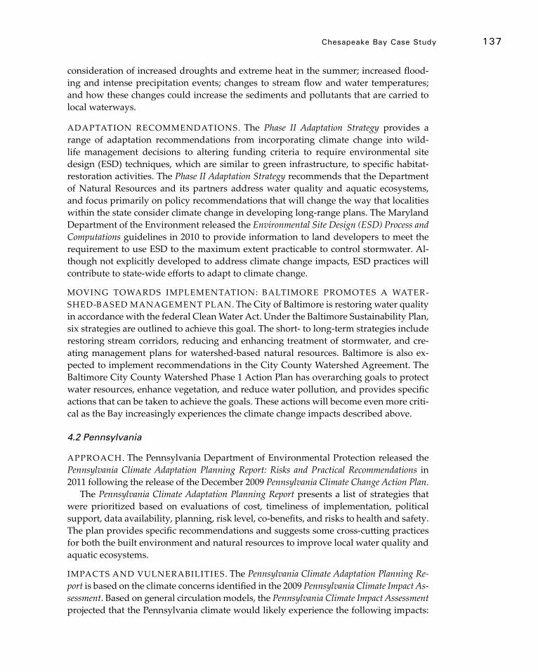
Chesapeake bay Case study 137
consideration of increased droughts and extreme heat in the summer; increased flood-ing and intense precipitation events; changes to stream flow and water temperatures; and how these changes could increase the sediments and pollutants that are carried to local waterways.
ADAPTATION RECOMMENDATIONS. The Phase II Adaptation Strategy provides a range of adaptation recommendations from incorporating climate change into wild-life management decisions to altering funding criteria to require environmental site design (ESD) techniques, which are similar to green infrastructure, to specific habitat-restoration activities. The Phase II Adaptation Strategy recommends that the Department of Natural Resources and its partners address water quality and aquatic ecosystems, and focus primarily on policy recommendations that will change the way that localities within the state consider climate change in developing long-range plans. The Maryland Department of the Environment released the Environmental Site Design (ESD) Process and Computations guidelines in 2010 to provide information to land developers to meet the requirement to use ESD to the maximum extent practicable to control stormwater. Al-though not explicitly developed to address climate change impacts, ESD practices will contribute to state-wide efforts to adapt to climate change.
MOVING TOWARDS IMPLEMENTATION: BALTIMORE PROMOTES A WATER-SHED-BASED MANAGEMENT PLAN. The City of Baltimore is restoring water quality in accordance with the federal Clean Water Act. Under the Baltimore Sustainability Plan, six strategies are outlined to achieve this goal. The short- to long-term strategies include restoring stream corridors, reducing and enhancing treatment of stormwater, and cre-ating management plans for watershed-based natural resources. Baltimore is also ex-pected to implement recommendations in the City County Watershed Agreement. The Baltimore City County Watershed Phase 1 Action Plan has overarching goals to protect water resources, enhance vegetation, and reduce water pollution, and provides specific actions that can be taken to achieve the goals. These actions will become even more criti-cal as the Bay increasingly experiences the climate change impacts described above.
4.2 Pennsylvania
APPROACH. The Pennsylvania Department of Environmental Protection released the Pennsylvania Climate Adaptation Planning Report: Risks and Practical Recommendations in 2011 following the release of the December 2009 Pennsylvania Climate Change Action Plan.
The Pennsylvania Climate Adaptation Planning Report presents a list of strategies that were prioritized based on evaluations of cost, timeliness of implementation, political support, data availability, planning, risk level, co-benefits, and risks to health and safety. The plan provides specific recommendations and suggests some cross-cutting practices for both the built environment and natural resources to improve local water quality and aquatic ecosystems.
IMPACTS AND VULNERABILITIES. The Pennsylvania Climate Adaptation Planning Re-port is based on the climate concerns identified in the 2009 Pennsylvania Climate Impact As-sessment. Based on general circulation models, the Pennsylvania Climate Impact Assessment projected that the Pennsylvania climate would likely experience the following impacts:
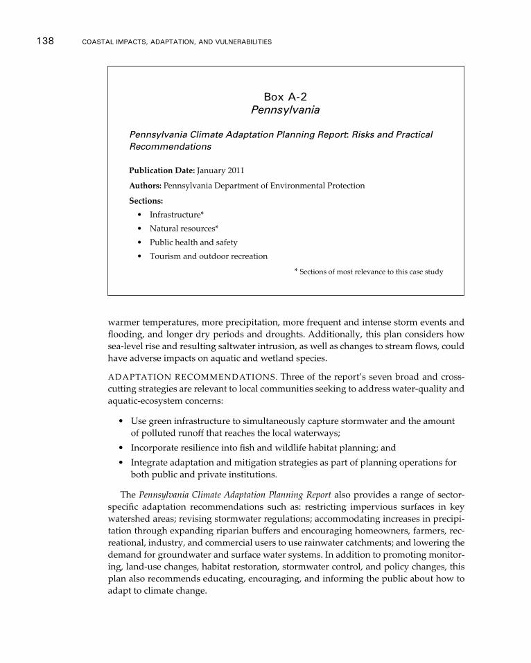
138 CoAsTAl ImpACTs, AdApTATIon, And VUlnerAbIlITIes
warmer temperatures, more precipitation, more frequent and intense storm events and flooding, and longer dry periods and droughts. Additionally, this plan considers how sea-level rise and resulting saltwater intrusion, as well as changes to stream flows, could have adverse impacts on aquatic and wetland species.
ADAPTATION RECOMMENDATIONS. Three of the report’s seven broad and cross-cutting strategies are relevant to local communities seeking to address water-quality and aquatic-ecosystem concerns:
• Use green infrastructure to simultaneously capture stormwater and the amount of polluted runoff that reaches the local waterways;
• Incorporate resilience into fish and wildlife habitat planning; and• Integrate adaptation and mitigation strategies as part of planning operations for
both public and private institutions.
The Pennsylvania Climate Adaptation Planning Report also provides a range of sector-specific adaptation recommendations such as: restricting impervious surfaces in key watershed areas; revising stormwater regulations; accommodating increases in precipi-tation through expanding riparian buffers and encouraging homeowners, farmers, rec-reational, industry, and commercial users to use rainwater catchments; and lowering the demand for groundwater and surface water systems. In addition to promoting monitor-ing, land-use changes, habitat restoration, stormwater control, and policy changes, this plan also recommends educating, encouraging, and informing the public about how to adapt to climate change.
Pennsylvania Climate Adaptation Planning Report: Risks and Practical Recommendations
Publication Date: January 2011
Authors: Pennsylvania Department of Environmental Protection
Sections:• Infrastructure*• Natural resources*• Public health and safety• Tourism and outdoor recreation
* Sections of most relevance to this case study
box A-2 Pennsylvania
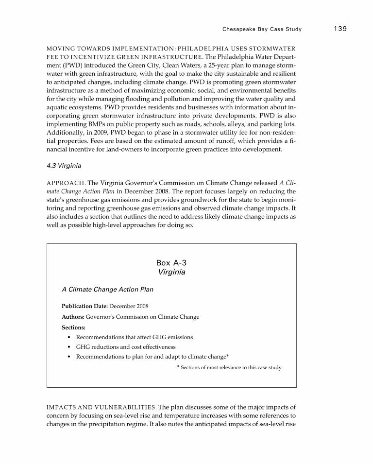
Chesapeake bay Case study 139
MOVING TOWARDS IMPLEMENTATION: PHILADELPHIA USES STORMWATER FEE TO INCENTIVIZE GREEN INFRASTRUCTURE. The Philadelphia Water Depart-ment (PWD) introduced the Green City, Clean Waters, a 25-year plan to manage storm-water with green infrastructure, with the goal to make the city sustainable and resilient to anticipated changes, including climate change. PWD is promoting green stormwater infrastructure as a method of maximizing economic, social, and environmental benefits for the city while managing flooding and pollution and improving the water quality and aquatic ecosystems. PWD provides residents and businesses with information about in-corporating green stormwater infrastructure into private developments. PWD is also implementing BMPs on public property such as roads, schools, alleys, and parking lots. Additionally, in 2009, PWD began to phase in a stormwater utility fee for non-residen-tial properties. Fees are based on the estimated amount of runoff, which provides a fi-nancial incentive for land-owners to incorporate green practices into development.
4.3 Virginia
APPROACH. The Virginia Governor’s Commission on Climate Change released A Cli-mate Change Action Plan in December 2008. The report focuses largely on reducing the state’s greenhouse gas emissions and provides groundwork for the state to begin moni-toring and reporting greenhouse gas emissions and observed climate change impacts. It also includes a section that outlines the need to address likely climate change impacts as well as possible high-level approaches for doing so.
IMPACTS AND VULNERABILITIES. The plan discusses some of the major impacts of concern by focusing on sea-level rise and temperature increases with some references to changes in the precipitation regime. It also notes the anticipated impacts of sea-level rise
A Climate Change Action Plan
Publication Date: December 2008
Authors: Governor’s Commission on Climate Change
Sections:• Recommendations that affect GHG emissions• GHG reductions and cost effectiveness• Recommendations to plan for and adapt to climate change*
* Sections of most relevance to this case study
box A-3 Virginia
140 CoAsTAl ImpACTs, AdApTATIon, And VUlnerAbIlITIes
on the Bay region. It identifies several foundation species at risk of declining or disap-pearing if salinity and temperatures continue to rise and weather patterns continue to fluctuate widely. The report also notes that increasing temperatures and storm runoff would decrease oxygen levels and negatively impact aquatic species. Saltwater intrusion caused by sea-level rise would also have a negative effect on Virginia’s coastal wetlands.
ADAPTATION RECOMMENDATIONS. The adaptation portion of A Climate Change Action Plan primarily focuses on disseminating information on climate change adapta-tion and preparedness while also providing some suggestions to address climate change in the future. The proposed preparedness strategies range from seeking recommenda-tions that complement existing goals to collaboration with neighboring states and other public and private sector partners. A Climate Change Action Plan also offers a series of recommendations for how local governments can incorporate climate change into their planning efforts. The plan recommends that all state discretionary funding programs should require that infrastructure projects be designed to withstand climate changes over the course of the project.
Four recommendations that could address water quality and aquatic ecosystems in the Bay are of note:
• Adaptation policies and programs for the built environment should take into consideration impacts on natural systems;
• The Virginia Department of Conservation and Recreation (DCR) should monitor available forecasting tools and amend its stormwater regulation as needed to ensure the implementation of stormwater management measures that will continue to function effectively in an altered precipitation regime;
• DCR should assess the consequences of climate change on the effectiveness of non-point source urban and agriculture best management practices; and
• The General Assembly should require local governments whose jurisdictions encompass Virginia’s shoreline to develop integrated shoreline management plans in coordination with Virginia Marine Resources Commission (VMRC). Such planning efforts would integrate adaptation and response strategies for coastal erosion, sea-level rise adaptation, and coastal storm surge into existing state and local policies.
MOVING TOWARDS IMPLEMENTATION: VIRGINIA BEACH INCORPORATES CLIMATE CHANGE INTO THE COMPREHENSIVE PLAN. The City of Virginia Beach’s 2009 Comprehensive Plan includes climate change as a hazard that the City should anticipate and calls for the continuation of practices that will contribute to climate change adaptation. This plan recommends actions to protect and manage water resourc-es. Water quality is to be maintained through: 1) the continuation of watershed resto-ration projects with partner agencies; 2) the achievement of the goals of the Southern Watersheds Area Management Program; 3) the development of a Watershed Manage-ment Plan; and 3) the management of stormwater. These practices will help ensure water quality for the benefits of habitat support, drinking, and water recreation. The City’s Plan also provides recommendations for adaptation to sea-level rise and storm surges.
141
appendix b
northern gulf of Mexico Case Study
The shores of the Gulf of Mexico support ecosystems and economies of national sig-nificance. According to the National Marine Fisheries Service, the commercial fish and shellfish harvest from the five U.S. Gulf states was estimated to be 1.3 billion pounds valued at $639 million in 2010. The Gulf also contains four of the nation’s top seven fish-ing ports by weight and eight of the nation’s top twenty fishing ports by dollar value. Gulf landings of shrimp and harvest of oysters lead the nation and the Gulf also houses a productive recreational fishery. In 2010, marine recreational participants took more than 20.7 million trips.
According to the Bureau of Ocean Energy Management, offshore operations in the Gulf produce a quarter of the U.S. domestic natural gas and one-eighth of its oil. In ad-dition, the offshore petroleum industry employs over 55,000 U.S. workers in the Gulf. Coastal communities and ports maintain this energy production by supporting the op-eration of offshore and inshore production facilities as well as onshore pipelines and processing plants.
Major Gulf ports include New Orleans, Baton Rouge, Houston, Mobile, and Lake Charles. More than 220 million tons of cargo moved through the Port of Houston in 2009. In 2008, the Port of Mobile had a trade volume of over 67 million tons. The cargo conveyed on the Mississippi River alone is estimated to have an approximately $115 bil-lion annual impact on the nation’s economy.
Vulnerable Coastal habitats and Communities
Global sea-level rise will have a disproportionate effect along the Gulf Coast shoreline be-cause of its flat topography, regional land subsidence, extensive shoreline development, and vulnerability to major storms. Considerable uncertainty remains about whether the regional climate will become wetter or drier in the future, but future trends in rainfall, runoff, and consequent soil moisture are critical to human and ecological well-being in the Gulf Coast. Freshwater availability influences coastal ecosystems through salinity gradients as well as agricultural production and many coastal industries and water sup-ply for municipalities.
Climate changes could also result in potential shifts in El Niño/La Niña cycles, hur-ricanes, storms, and coastal ocean currents; however, even if storm intensities remain constant disturbance from coastal flooding and erosion will increase because rising sea levels will generate higher storm surges even from minor storms. The effects of recent storms, including Katrina and Rita in 2005, have been dramatic and demonstrate the vulnerability of large population centers like New Orleans and Houston.
However, in addition to the dramatic, newsworthy events associated with major events, the rural communities of the Gulf Coast are also of concern due to their existing

142 CoAsTAl ImpACTs, AdApTATIon, And VUlnerAbIlITIes
social vulnerability. The figure below (Figure B-1) shows how indices of coastal vulner-ability (CVI) merged with indices of social vulnerability (CSoVI) produces a place vul-nerability index (PVI) with high values in the counties of coastal Louisiana and Texas.
A ‘Laboratory’ for understanding Coastal Change and Testing new Approaches
The northern Gulf of Mexico provides an excellent laboratory for considering the effects of future climate change for several reasons:
• Adaptation and change are already integral. From ecosystems to communi-ties, change is both inevitable and already happening. The deltaic wetlands of coastal Louisiana are in a constant state of change associated with growth and degradation of delta lobes, and a northward shift in the limit of persistent mangrove growth is already underway. Although these changes are associated with both gradual and pulsed forcing, coastal communities change in response to storm events. Although the conventional wisdom tells us that relocating or elevating coastal residents is difficult, post-storm efforts in coastal Louisiana and
Figure B-1 Vulnerability of Gulf Coast counties based on physical (CVI) and social (CSoVl) indicators and their integration into place vulnerability (PVI). Based on: Boruff et al., 2005; Pendleton et al., 2010.
northern Gulf of mexico Case study 143
Mississippi that include financial assistance or incentives have proven successful at least locally. The relocation aspects of the Mississippi Coastal Improvement Program (MsCIP) have been over-subscribed, and the availability of generous home elevation grants in Louisiana has stimulated growth in the ‘elevation’ industry, in which private contractors often help residents with paperwork and grant applications.
• Interactions between coastal change and watershed change. Understanding the consequences of climate change for coastal systems requires a parallel and inte-grated recognition of upstream changes. The northern Gulf provides an excel-lent opportunity to explore this relationship because of the range of watersheds draining into the Gulf. The Mississippi is the 3rd largest watershed in the world and integrates climate change effects on runoff at the continental scale and the interaction with river management. At a small scale, the Pascagoula drainage is one of the only unregulated drainage systems in the U.S. Between the two in scale are watersheds that drain areas more likely subject to drought such as Texas and areas where trends in precipitation are less clear such as the south-eastern region.
• Continuing investment in coastal restoration. In addition to ongoing restora-tion efforts, such as Coastal Wetlands Planning, Protection, and Restoration Act, better understanding of sea level change, sediment delivery, and tempera-ture and precipitation regimes is essential if ecosystem restoration projects to be implemented as a consequence of the 2010 British Petroleum oil spill are to provide sustainable benefits.
144
references
Abuodha, P. & Woodroffe, C. (2010). Assessing vulnerability to sea-level rise using a coastal sensitivity index: A case study from southeast Australia. Journal of Coastal Conservation, 14, pp. 189-205.
ACIA. (2005). Arctic Climate Impact Assessment. Cambridge University Press, Cambridge, UK, and New York, 1042 pp. Retrieved from http:// www.acia.uaf.edu/pages/scientific.html.
Adaptation Advisory Committee. (2011). Massachusetts climate change adaptation report. Execu-tive Office of Energy and Environmental Affairs and the Adaptation Advisory Committee, Boston, MA.
Adaptation Advisory Group. (2010). Alaska’s Climate Change Strategy: Addressing Impacts to Alaska, Final Draft Report, January 27, Alaska Department of Environmental Conservation, 04 pp. plus appendices.
Aggarwal, P. K. & Singh, A. K. (2010). Water Resources Development and Management. In: Implications of Global Climatic Change on Water and Food Security. Springer, Berlin Heidelberg, pp. 49-63.
Ahmad, F., Rauch, S. & Hodor, M. (2009). Oil and gas development in the Arctic Ocean. Sea Tech-nology, 50(40), pp. 51-55.
Allan, J.C. & Komar, P.D. (2000). Are ocean wave heights increasing in the eastern North Pacific? EOS, Transaction of the American Geophysical Union, 81(47), pp. 561-567.
Allan, J.C. & Komar, P.D. (2006). Climate controls on U.S. West Coast erosion processes. Journal of Coastal Research, 22, pp. 511-529.
Allen, M.R., & Ingram, W.J. (2002). Constraints on future changes in climate and the hydrologic cycle. Nature, 418, pp. 224-232.
American Society of Civil Engineers (ASCE). (2009). Critical Infrastructure Guidance Task Committee, ASCE Guiding Principles for the Nation’s Critical Infrastructure. Retrieved from http://content.asce.org/files/pdf/GuidingPrinciplesFinalReport.pdf.
Anderson, C.R., Sapiano, M.R.P., Balakrishna Prasad, M., Long, W. Tango, P.J. Brown, C.W., & Murtugudde. R. (2010). Predicting potentially toxigenic Pseudo-nitzschia blooms in the Chesapeake Bay. Journal of Marine Systems. 83(3-4), pp. 127-140.
Anderson, J., Milliken, K., Wallace, D., Rodriguez, A., & Simms, A. (2010). Coastal impact under-estimated from rapid sea level rise. EOS Transactions, American Geophysical Union, 91(23), pp. 205-206, doi:10.1029/2010EO230001.
Anthony, A., Atwood, J., August, P., Byron, C., Cobb, S., Foster, C., Fry, C., Gold, A., Hagos, K., Heffner, L., Kellogg, D.Q., Lellis-Dibble, K., Opaluch, J.J., Oviatt, C., Pfeiffer-Herbert, A., Rohr, N., Smith, L., Smythe, T., Swift, J., & Vinhateiro, N. (2009). Coastal lagoons and climate change: ecological and social ramifications in U.S. Atlantic and Gulf coast ecosystems. Ecology and Society, 14(1), pp. 8. Retrieved from http://www.ecologyandsociety.org/vol14/iss1/art8/.
Archer, D. (2007). Methane hydrate stability and anthropogenic climate change. Biogeosciences, 4, pp. 521-544.
Are, F, Reimnitz, E., Grigoriev, M., Hubberten, H.-W., & Rachold, V. (2008). The Influence of Cryogenic Processes on the Erosional Arctic Shoreface. Journal of Coastal Research, 24, pp. 110 – 121.
Arendt, A, Walsh, J., & Harrison, W. (2009). Changes of Glaciers and Climate in Northwestern
North America during the Late Twentieth Century. Journal of Climate, 22, pp. 4117-4134. Arroyo,V. & Cruce, T.L. (2012). State and Local Adaptation to Climate Change. In: The Law of
Adaptation to Climate Change, Michael B. Gerrard & Katrina F. Kuh (Eds.).Ashton, A.D., Walkden, M.J.A., Dickson, M.E., (2011). Equilibrium responses of cliffed coasts to
changes in the rate of sea level rise. Marine Geology, 284, pp. 217-229.Atalah, J., Crowe, T.P. (2010). Combined effects of nutrient enrichment, sedimentation and grazer
loss on rock pool assemblages. Journal of Experimental Marine Biology and Ecology, 388(1-2), pp. 51-57
Atkinson, D.E. & Hinzman, L. (2008). Impact of the August 2000 storm on the soil thermal regime, Alaska North Slope. Conference Proceedings, Published Collection: Proceedings of the 9th International Conference on Permafrost, Fairbanks, Alaska, 29 June -3 July 2008, pp. 65-70.
Atkinson, D.E. (2005). Environmental Forcing of the Circum-polar coastal Regime. GeoMarine Letters, 25, pp.98-109.
Atkinson, D.E. (2011). The physical environment of Alaska’s coasts. In: Lovecraft, A. L., Eicken, H. (Eds.) North by 2020 – Perspectives on Alaska’s changing social-ecological systems. Univer-sity of Alaska Press, Fairbanks, pp. 229-252. Retrieved from http://www.sfrpc.com/climat-echange.htm.
Atkinson, D.E., Schweitzer, P., Smith, O. & Norris, L. (2011). The Arctic Coastal System: An Inter-play of Components Human, Industrial, and Natural. In: Lovecraft, A. L., Eicken, H. (Eds.) North by 2020 – Perspectives on Alaska’s changing social-ecological systems. University of Alaska Press, Fairbanks, pp. 277-298.
Bacon, S. & Carter, D.J.T. (1991). Wave climate changes in the North Atlantic and North Sea. Inter-national Journal of Climatology, 11, pp. 545-558.
Bamber, J.L., Riva, R.E.M., Vermeersen, B.L.A., & LeBrocq, A.M. (2009). Reassessment of the Potential Sea-Level Rise from a Collapse of the West Antarctic Ice Sheet. Science, 324, pp. 901-903.
Bates, B.C., Kundzewicz, Wu, S., & Palutikof, J.P. (Eds.). (2008). Climate Change and Water. Tech-nical Paper of the Intergovernmental Panel on Climate Change, IPCC Secretariat, Geneva, 210 pp.
Bauer. L.J. (2006). Winter mortality of the blue crab (Callinectes sapidus) in the Chesapeake Bay. Master’s thesis, University of Maryland.
Beach, D. (2002). Coastal Sprawl: The effects of urban design on aquatic ecosystems in the United States. Pew Oceans Commission. Retrieved from http://www.pewtrusts.org.
Becker, A., et al. (2011). Climate change impacts on international seaports: Knowledge, percep-tions, and planning efforts among port adminstrators. Journal of Climatic Change, DOI: 10.1007/s10584-011-0043-7
Beever, J., Gray, W., Trescott, D., Cobb, D., Utley, J., Hutchinson, D., Gibbons, J., Walker, T., Abimbola, M., Beever, L., and Ott, J. (2009, November 18). City of Punta Gorda Adaptation Plan, Southwest Florida Regional Planning Council and Charlotte Harbor National Estuary Program, Fort Meyers, FL. Technical Report 09-4.
Bender, M. A., Knutson, T.R., Tuleya, R.E., Sirutis, J.J., Vecchi, G.A., Garner, S.T., & Held, I.M. (2010). Modeled impact of anthropogenic warming on the frequency of intense Atlantic hurricanes. Science, 327(5964), doi:10.1126/science.1180568.
Benedict, M.A. & McMahon, E.T. (2006). Green Infrastructure: Linking Landscapes and Communities. Washington, D.C., Island Press, 320 pp.
Berke, P., Smith, G., & Lyles, W. (In press). Planning for Resiliency: An Evaluation of Coastal State Hazard Mitigation Plans. Natural Hazards Review.
references 145
146 CoAsTAl ImpACTs, AdApTATIon, And VUlnerAbIlITIes
Berkowitz, B. (2011, August 31). Special Report: Irene Wallops Flood Insurance Program, Reuters. Retrieved from http://www.reuters.com/article/2011/08/31/us-storm-irene-flood-idUSTRE77T5M620110831.
Berkowitz, B. (2011, September 4). Scenarios - Katia and Lee Threaten Insurance Compa-nies, Reuters. Retrieved from http://www.reuters.com/article/2011/09/04/us-storm-insurance-idUSTRE7832IJ20110904.
Berrang-Ford, L., Ford, J.D., & Paterson, J. (2011). Are we adapting to climate change? Global Environmental Change, 21, pp. 25-33.
Berry, H.L., Bowen, K., Kjellstrom, T. (2010). Climate change and mental health: a causal path-ways framework. International Journal of Public Health, Volume 55, Number 2, 123-132, DOI: 10.1007/s00038-009-0112-0.
Bertness, M.D. & Ewanchuk, P.J. (2002). Latitudinal and climate-driven variation in the strength and nature of biological interactions in New England salt marshes. Oecologia, 132, pp. 392-401.
Bin, O., Dumas, C., & Poulter, B. (2007). Measuring the Impacts of Climate Change on North Carolina Coastal Resources. National Commission on Energy Policy. Washington, DC.
Bindoff, N.L. and coauthors. (2007). Observations: Oceanic climate change and sea level, Climate Change 2007: The Physical Science Basis, S. Solomon et al., (Eds.), Cambridge University Press, pp. 385-432.
Bird, E. (2011). Coastal Geomorphology: An Introduction. 2nd Edition. John Wiley and Sons, Inc., West Sussex, England.
Birkmann, J., Garschagen, M., Kraas, F., & Quang, N. (2010). Adaptive urban governance: new challenges for the second generation of urban adaptation strategies to climate change. Sustainability Science, 5(2) pp. 185-206.
Bjarnadottir, S., Li, Y., & Stewart, M.G. (2011). Social vulnerability index for coastal communities at risk to hurricane hazard and a changing climate. Natural Hazards, 59, pp. 1055-1075.
Blackwell, K.D. & Oliver, J.D. (2008). The ecology of Vibrio vulnificus, Vibrio cholerae, and Vibrio parahaemolyticus in North Carolina estuaries. Journal of Microbiology. 46, pp.146-153.
Bloom, A.A., Palmer, P.I., Fraser, A., Reay, D.S., & Frankenberg, C. (2010). Large-Scale Controls of Methanogenesis Inferred from Methane and Gravity Spaceborne Data. Science, 327(5963), pp. 322–325.
Blum, M.D., Roberts, H.H. (2009). Drowning of the Mississippi delta due to insufficient sediment supply and global sea-level rise. Nature Geoscience, 2, pp. 488-491.
Blunden, J., Arndt, D.S., & Baringer, M.O. (Eds.). (2011). State of the Climate in 2010. Bulletin of the American Meteorological Society, 92(6), pp. S1–S266.
Boesch, D.F., Coles, V.J., Kimmel, D.G., & Miller, W.D. (2007). Coastal dead zones and global climate change: Ramifications of climate change for Chesapeake Bay hypoxia. Excerpted from Regional Impacts of Climate Change: Four Case Studies in the United States, Pew Center on Global Climate Change, Arlington, Virginia, 20 pp.
Bookman, C.A., Culliton, T.J., & Warren, M.A. (1999). Trends in U.S. Coastal Regions, 1970-1998. Addendum to the Proceedings, Trends and Future Challenges for U.S. National Ocean and Coastal Policy. National Oceanic and Atmospheric Administration (NOAA).
Borja, Á., Dauer, D., Elliott, M., et al. (2010). Medium- and Long-term Recovery of Estuarine and Coastal Ecosystems: Patterns, Rates and Restoration Effectiveness. Estuaries and Coasts, 33(6), pp. 1249-1260.
Boruff, B.J., Emrich, C., & Cutter, S.L. (2005). Erosion hazard vulnerability of U.S. coastal coun-ties. Journal of Coastal Research, 21(5), pp. 932-942.

references 147
Bossart, G.D. (2011). Marine Mammals as Sentinel Species for Oceans and Human Health. Veteri-nary Pathology, 48(3) pp. 676-690
Breen, A. & Rigby, D. (1985). Caution, working waterfront: the impact of change on marine enterprises. Waterfront Press.
Bricker, S., Longstaff, B., Dennison, W., Jones, A., Boicourt, K., Wicks, C., & Woerner, J. (2007). Effects of Nutrient Enrichment In the Nation’s Estuaries: A Decade of Change. NOAA Coastal Ocean Program Decision Analysis Series No. 26. National Centers for Coastal Ocean Science, Silver Spring, MD, 328 pp. Retrieved from http://ian.umces.edu/neea/.
Briske, D.D., Fuhlendorf, S.D. & Smeins, F.E. (2006). A unified framework for assessment and application of ecological thresholds. Rangeland Ecology & Management, 59(3), pp. 225-236.
Bromirski, P.D., Miller, A.J., Flick, R.E., & Auad, G. (2011). Dynamical suppression of SLR along the Pacific coast of North America: Indications for imminent acceleration, Journal of Geophys-ical Research – Oceans, 116, C07005, doi:10.1029/2010JC006759.
Brown, C., Campbell, S., Henry, L.R., & Robinson, M.M. (2009). Public Listening Sessions Report: Sea Level Rise and Population Growth in North Carolina: The Albemarle-Pamlico Conserva-tion and Communities Collaborative and the Albemarle-Pamlico National Estuary Program. Retrieved from http://www.cakex.org/virtual-library/826.
Buonaiuto, F., Patrick, L., Gornitz, V., Hartig, E., Leichenko, R., & Vancura, P. (2010). Coastal Zones, Chapter 5, pp. 122-162, in NYSERDA ClimAID Team. Integrated Assessment for Effective Climate Change Adaptation Strategies in New York State. C. Rosenzweig, W. Solecki, A. DeGaetano, M. O’Grady, S. Hassol, P. Grabhorn, (Eds.). New York State Energy Research and Development Authority (NYSERDA), 17 Columbia Circle, Albany, New York, 12203.
Burke, E.J., Brown, S.J., & Christidis, N. (2006). Modeling the recent evolution of global drought and projections for the 21st century with the Hadley Centre Climate Model. Journal of Hydro-meteorology, 7(5), pp. 1113–1125.
Burkett, V.R. (2011). Global climate change implications for coastal and offshore oil and gas development. Energy Policy, 39, pp. 7719–7725.
Burkett, V.R., Nicholls, R.J., Fernandez, L. & Woodroffe, C.D. (2008). Climate change impacts on coastal biodiversity. Research Online, pp. 167-193. Retrieved from http://ro.uow.edu.au/scipapers/217.
Burkett, V.R., Wilcox, D. A., Stottlemyer, R., Barrow, W., Fagre, D., Baron, J., Price, J., Nielsen, J. L., Allen, C. D., Peterson, D. L., Ruggerone, G. & Doyle, T. (2005). Nonlinear dynamics in ecosystem response to climate change: Case studies and policy implications. Ecological Complexity, 2, pp. 357-394.
Burnett, M, Carbin, G., & Schaefer, J. (2008). An Analysis of the 2007-2008 Tornado Cool Season. National Weather Center Research Experience for Undergraduates, Norman, OK and University of Missouri, Columbia, MO. Retrieved from http://www.caps.ou.edu/reu/reu08/Final%20Papers/Burnett_final_paper.pdf.
Burton, C. G. (2010). Social vulnerability and hurricane impact modeling. Natural Hazards Review, 11(2), pp. 58-68.
Caffrey, M., & Beavers, R. (2008). George Wright Forum, Protecting Cultural Resources in U.S. National Parks from Climate Change, 25(2), pp. 86-97.
Cahoon, D. (2006). A review of major storm impacts on coastal wetland elevations. Estuaries and Coasts, 29(6), pp. 889-898.
Cahoon, D.R., Hensel, P.F., Spencer, T., Reed, D.J., Mc-Kee, K.L., & Saintilan, N. (2006). Coastal wetland vulnerability to relative sea-level rise: wetland elevation trends and process
148 CoAsTAl ImpACTs, AdApTATIon, And VUlnerAbIlITIes
controls. In: Wetlands and Natural Resource Management [Verhoeven, J.T.A., B. Beltman, R. Bobbink, and D. Whigham (Eds.)]. Ecological studies volume 190. Springer, Berlin and New York, pp. 271-292.
Cahoon, D.R., Lynch, J.C., & Powell, A.N. (1996). Marsh vertical accretion in a southern Cali-fornia estuary, USA. Estuarine Coastal and Shelf Science, 43, pp. 19-32.
Cahoon, D.R., Reed, D.J., Kolker, A.S., Brinson, M.M., Stevenson, J.C., Riggs, S., Christian, R., Reyes, E., Voss, C. & Kunz, D. (2009). Coastal wetland sustainability. In, Coastal Sensitivity to Sea-Level Rise: A Focus on the Mid-Atlantic Region. A report by the U.S. Climate Change Science Program and the Subcommittee on Global Change Research. J.G. Titus (coordinating lead author), K.E. Anderson, D.R. Cahoon, D.B. Gesch, S.K. Gill, B.T. Gutierrez, E.R. Thieler, and S.J. Williams (lead authors). U.S. Environmental Protection Agency, Washington DC, pp. 57-72.
Caires, S., Swail, V.R., & Wang, X.L. (2006). Projection and Analysis of Extreme Wave Climate. Journal of Climate, 19(21), pp. 5581, doi: 10.1175/JCLI3918.1
Cardoso, P.G., Leston, S., Grilo, T.F., et al. (2010). Implications of nutrient decline in the seagrass ecosystem success. Marine Pollution Bulletin, 60(4), pp. 601-608.
Cardoso, P.G., Raffaelli, D., Lillebø, A.I., et al. (2008). The impact of extreme flooding events and anthropogenic stressors on the macrobenthic communities’ dynamics. Estuarine, Coastal and Shelf Science, 76(3), pp. 553-565.
Carter, D.J.T. & Draper, L. (1988). Has the north-east Atlantic become rougher? Nature, 332, pp. 494.
Cato Institute. (2001). Cato Handbook for Congress: Policy Recommendations for the 107th Congress, pp. 431-439. Retrieved from http://www.cato.org/pubs/handbook/hb107/hb107-40.pdf
Cayan, D.R., Bromirski, P.D., Hayhoe, K., Tyree,M., Dettinger, M.D., & Flick, R.E. (2008). Climate change projections of the sea level extremes along the California coast. Climatic Change, 87, pp. S57-S73.
CCSP (Climate Change Science Program), 2009b. Thresholds of climate change in ecosystems. Fagre, D.B., Charles, C.W., Allen, C.D., Birkeland, C., Chapin III, F.S., Groffman, P.M., Guntenspergen, G.R., Knapp, A.K., McGuire, A.D., Mulholland, P.J., Peters, D.P.C., Roby, D.D., and Sugihara, G. A Report by the U.S. Climate Change Science Program and the Subcommittee on Global Change Research. U.S. Geological Survey, Reston, VA.
CCSP (Climate Change Science Program). (2008). Impacts of Climate Change and Variability on Transportation Systems and Infrastructure: Gulf Coast Study, Phase I, in: Savonis, M.J., V.R. Burkett, and J.R. Potter (Eds.), Synthesis and Assess ment Product 4.7., U.S. Department of Transportation, Washington, DC, 445 pp.
CCSP (Climate Change Science Program). (2009a). Coastal Sensitivity to Sea-Level Rise: A Focus on the Mid-Atlantic Region. A report by the U.S. Climate Change Science Program and the Subcommittee on Global Change Research. [James G. Titus (Coordinating Lead Author), K. Eric Anderson, Donald R. Cahoon, Dean B. Gesch, Stephen K. Gill, Benjamin T. Gutierrez, E. Robert Thieler, and S. Jeffress Williams (Lead Authors)]. U.S. Environmental Protection Agency, Washington D.C., USA, 320 pp.
CDC (Centers for Disease Control). (2009). Vector-borne and zoonotic diseases. Retrieved from http://www.cdc.gov/climatechange/effects/vectorborne.htm.
CDC (Centers for Disease Control). (2012). Dengue and Climate. Retrieved from http://www.cdc.gov/dengue/entomologyEcology/climate.html.
references 149
Cela, M., Hulsey, J., & Titus, J.G. (2010). South Florida. In The Likelihood of Shore Protection along the Atlantic Coast of the United States. Volume 2. Report by the South Florida Regional Planning Council to the U.S. Environmental Protection Agency. Washington, D.C. pp. 515-585
Center for Ocean Solutions. (2011). Decision Guide: Selecting Decision Support Tools for Marine Spatial Planning. The Woods Institute for the Environment, Stanford University, California. Environmental Modelling Software. 26(5), pp.593-604.
Chen, J.L., Wilson, C.R., & Tapley, B.D. (2011). Interannual variability of Greenland ice losses from satellite gravimetry. Journal of Geophysical Research, 116:B07406 doi:10.1029/2010JB007789.
Christensen, F.T. (1994). Ice Ride-up and Pile-up on Shores and Coastal Structures. Journal of Coastal Research, 10(3), pp. 681-701.
Chu-Agor, M.L., Muñoz-Carpena, R., Kiker, G., Emanuelsson, A., & Linkov I. (2011) Exploring sea level rise vulnerability of coastal habitats through global sensitivity and uncertainty analysis. Environmental Modelling Software. doi: 10.1016/j.envsoft.
Church, J.A. & White, N.J. ( 2011). Sea-level rise from the late 19th to the early 21st Century. Surveys in Geophysics, doi:10.1007/s10712-011-9119-1.
Church, J.A. & White, N.J. (2006). A 20th century acceleration in global sea-level rise, Geophysical Research Letters, 33, L01602, doi:10.1029/2005GL024826.
Church, J.A., White, N. J., Konikow, L. F., Domingues, C. M., Cogley, J. G., Rignot, E., et al. (2011). Revisiting the Earth’s sea‐level and energy budgets from 1961 to 2008. Geophysical Research Letters, 38, L18601.
Church, J.A., Woodworth, P.L., Aarup, T., & Wilson W.S. (Eds.). (2010). Sea-level rise and vari-ability, Wiley-Blackwell, 428 pp.
Claessens, L., Schoorl, J.M., Verburg, P.H., et al. (2009). Modelling interactions and feedback mechanisms between land use change and landscape processes. Agriculture, Ecosystems and Environment, 129, pp. 157-170.
Clark, W., Kassakian, J., & Titus, J.G. (2010). North Carolina. In The Likelihood of Shore Protection along the Atlantic Coast of the United States, Volume 1. . Report by North Carolina Seagrant to the U.S. Environmental Protection Agency, Washington, D.C. pp. 889-1032.
Cloern, J.E. (1987). Turbidity as a control on phytoplankton biomass and productivity in estu-aries. Continental Shelf Research, 7, pp. 1367-1381.
Cloern, J.E., Jassby, A.D., Thompson, J.K., &. Hieb, K.A. (2007). A cold phase of the East Pacific triggers new phytoplankton blooms in San Francisco Bay. Proceedings of the National Academy of Sciences, 104, pp. 18561–18565. doi:10.1073/pnas.0706151104.
Cloern, J.E., Knowles, N., Brown, L.R., Cayan, D., Dettinger, M.D., Morgan, T.L., Schoellhamer, D.H., Stacey, M.T., van der Wegen, M., Wagner, R.W., & Jassby, A.D. (2011). Projected evolu-tion of California’s San Francisco Bay-Delta-River system in a century of climate change. PLoS ONE, 6: e24465. doi:10.1371/journal.pone.0024465.
Colgan, C.S. (2004). The contribution of working waterfronts to the Maine economy. Maine’s Working Waterfront Coalition. Retrieved from http://muskie.usm.maine.edu/Publications/Working-Waterfronts.pdf
Colle, B.A., Buonaiuto, F., Bowman, M.J., Wilson, R.E., Flood, R., Hunter, R. & Hill, D. (2008). New York City’s vulnerability to coastal flooding - Storm surge modeling of past cyclones. Bulletin of the American Meteorological Society, 89(6), pp. 829-841. doi: 10.1175/2007bams2401.1.
Collins, M., An, S.I., Cai, W.J., Ganachaud, A., Guilyardi, E., Jin, F.F., Jochum, M., Lengaigne, M., Power, S., Timmermann, A., Vecchi, G. & Wittenberg, A. (2010). The impact of global warming on the tropical Pacific ocean and El Nino. Nature Geoscience, 3(6), pp. 391-397.
150 CoAsTAl ImpACTs, AdApTATIon, And VUlnerAbIlITIes
Colwell, R. R. (2008). Warming Oceans, Increasing Disease (Mapping the Health Effects of Climate Change). In: 2008-2009 State of the Wild, A Global Portrait of Wildlife, Wildlands, and Oceans, Wildlife Conservation Society, Eva Fearn, Kent H. Redford, (Eds.). Part II, pp. 115-118. Island Press, Washington, DC.
Commerce Secretary Gary Locke Announces $167 Million in Recovery Act Funding for 50 Coastal Resto-ration Projects . June 30, 2009. <http://www.noaanews.noaa.gov/stories2009/20090630_resto-ration.html.>
Concannon, T., Hussain, M., Hudgens, D., & Titus, J.G. (2010). Georgia. In The Likelihood of Shore Protection along the Atlantic Coast of the United States. Volume 2: New England and the Southeast. Report by the Coastal Georgia Regional Development Commission to the U.S. Environ-mental Protection Agency. Washington, DC, pp. 255-322.
Conner, W.H., Doyle, T.W. & Krauss, K.W. (Eds.). (2007a). Ecology of tidal freshwater forested wetlands of the Southeastern United States: The Netherlands, Springer, 505 pp.
Conner, W.H., Krauss, K.W. & Doyle, T.W. (2007b). Ecology of tidal freshwater forests in coastal deltaic Louisiana and northeastern South Carolina. In, Conner, W.H., Doyle, T.W. and Krauss, K.W. (Eds.), Ecology of tidal freshwater forested wetlands of the Southeastern United States: The Netherlands, Springer, pp. 223-253.
Conrads, P.A., Roehl, E.A., Sexton, C.T., Tufford, D.L., Carbone, G.J., Dow, K., & Cook, J.B. (2010). Estimating salinity intrusion effects due to climate change along the Grand Strand of the South Carolina coast. Conference Proceedings Paper for the 4th Federal Interagency Hydrologic Modeling Conference. Las Vegas, NV, June 2010.
Convention on Biological Diversity. (2010). Global Biodiversity Outlook 3. Montreal. Retrieved from http://www.cbd.int/doc/publications/gbo/gbo3-final-en.pdf.
Cooley, D. & Olander, L. (2011). Stacking ecosystem services payments: Risks and solutions. Nicholas Institute for Environmental Policy Solutions Report NI WP 11-04, Duke University.
Cooper M.J.P., Beevers, M.D., & Oppenheimer, M. (2005). Future sea-level rise and the New Jersey coast. Science Technology and Policy Program, Woodrow Wilson School of Public and International Affairs, Princeton University, Princeton, NJ.
Cordesman, A.H. & Fitzgerald, E.K. (2009). The 2010 Quadrennial Defense Review: A+, F, or Dead on Arrival?, September 9, 2009. Center for Strategic and International Studies. Retrieved from http://csis.org/publication/2010-quadrennial-defense-review.
Craghan, M.C, Kassakian, J., Hudgens, D., & Titus, J.G. (2010). New Jersey. In James G. Titus and Daniel Hudgens (Eds.). The Likelihood of Shore Protection along the Atlantic Coast of the United States. Volume 1: Mid-Atlantic. Report to the U.S. Environmental Protection Agency. Wash-ington, D.C. pp. 261-385.
Crain, C.M., Halpern, B.S., Beck, M.W., et al. (2009). Understanding and Managing Human Threats to the Coastal Marine Environment. Annals of the New York Academy of Sciences, 1162(1), pp. 39-62.
Crist, P., Madden, K., Varley, I., Eslinger, D., Walker, D., Anderson, A., Morehead, S., & Dunton, K. (2012). Integrated Land-Sea Planning: Technical Guide to the Integrated Land-Sea Plan-ning Toolkit. EBM Tools Network. Retrieved from www.ebmtools.org.
Crooks, S., Emmett-Mattox, S. & Findsen, J. (2010). Findings of the National Blue Ribbon Panel on the Development of a Greenhouse Gas Protocol for Tidal Wetlands Restoration and Management: Action Plan to Guide Protocol Development. Arlington, VA: Restore America’s Estuaries.
Crooks, S., Herr, D., Tamelander, J., Laffoley, D., & Vandever, J. (2011). Mitigating Climate Change through Restoration and Management of Coastal Wetlands and Near-shore Marine Ecosystems. Environmental Department Paper 121, Washington, DC: World Bank.
references 151
Crossett, K.M., Culliton, T.J., Wiley, P.C., & Goodspeed, T.R. (2004). Population Trends Along the Coastal United States: 1980-2008. National Oceanic and Atmospheric Administration. Retrieved from http://coastalsocioeconomics.noaa.gov/assessment/welcome.html.
Cruz, A.M. & Krausmann, E. (2008). Damage to offshore oil and gas facilities following hurri-canes Katrina and Rita: an overview. Journal of Loss Prevention in the Process Industries, 21(6), pp. 620-626.
Culver, M.E., Schubel, J.R., Davidson, M.A., Haines, J., & Texeira, K.C. (Eds.). (2010). Proceedings from the Sea Level Rise and Inundation Community Workshop, Landsdowne, VA, Dec 3-5 2009. Sponsored by the National Oceanic and Atmospheric Administration and U.S. Geolog-ical Survey, 81pp.
Cutter, S.L., Johnson, L.A., Finch, C., & Berry, M. (2007). The U.S. Hurricane Coasts: Increasingly Vulnerable? Environment, 49(7), pp. 8-20.
Dahl, T.E. (2011). Status and Trends of Wetlands in the Conterminous United States 2004 - 2009. Wash-ington, DC: U.S. Department of the Interior, Fish and Wildlife Service.
Dahl, T.E., & Johnson, C.E. (1991). Status and Trends of Wetlands in the Conterminous United States, Mid-1970’s to Mid-1980’s. Washington, DC: U.S. Department of the Interior, Fish and Wildlife Service.
Dai, A., Trenberth, K. E., & Qian, T. (2004). A global dataset of Palmer drought severity index for 1870–2002: Relationship with soil moisture and effects of surface warming. Journal of Hydro-meteorology, 5, pp. 1117-1130.
Data and Tools for Incorporating Climate Change Impacts into Community Planning and Project Design. (2011, March 30). MetroCenter, 101 Eighth Street Oakland, CA 94607.
Davidson, M.A. & Kana, T.W. (1988). Future sea-level rise and its Implications for Charleston, South Carolina. In M. H. Glantz, ed., Societal responses to regional climate change: Forecasting by analogy. Boulder, CO: Westview Press.
Davis, J.L. & Mitrovica, J.X. (1996). Glacial isostatic adjustment and the anomalous tide gauge record of eastern North America. Nature, 379, pp. 331–333.
Day, J.W.J., Mitsch, W.J., Orth, K., Mashriqui, H., Reed, R.J., Shabman, L., Simenstad, C.A., Streever, B.J., Twilley, R.R., Watson, C.C., Wells, J.T., & Whigham, D.F. (2007). Restoration of the Mississippi Delta: Lessons from Hurricanes Katrina and Rita. Science, 315(5819), pp. 1679-1684.
Debernard, J.B. & Roed, L.P. (2008). Future wind, wave and storm surge climate in the Northern Seas: a revisit. Tellus, 60A, pp. 427-438.
Delaune, R.D. & Wright, A.L. (2011). Projected Impact of Deepwater Horizon Oil Spill on US Gulf Coast Wetlands. Soil Science Society of America Journal, 75(5), pp. 1602-1612.
Delpla, I., Jung, A.-V., Baures, E., Clement, M., & Thomas, O. (2009). Impacts of climate change on surface water quality in relation to drinking water production. Environment International, 35(8), pp. 1225-1233.
Derksen, C. & Brown, R. (2011). Snow [in Arctic Report Card 2011], Retrieved from http://www.arctic.noaa.gov/reportcard/snow.html.
Dickens, G.R. (2001). Modeling the global carbon cycle with gas hydrate capacitor: Significance for the latest Paleocene thermal maximum, in: Paull, C.K., and W.P. Dillon (Eds.), Natural Gas Hydrates: Occurrence, Distribution, and Detection. Geophysical Monographs, 124, Amer-ican Geophysical Union, Washington, DC, pp. 19-38.
Dickhoff, W.D., Collier, T.K., & Varanasi, U. (2007). The Seafood Dilemma: A Way Forward. Guest Director’s Line. Fisheries, 32, pp. 244-246.
152 CoAsTAl ImpACTs, AdApTATIon, And VUlnerAbIlITIes
Dietz, M.E. (2007). Low impact development practices: A review of current research and recom-mendations for future directions. Water Air and Soil Pollution, 186(1-4), pp.351-363.
DOD (U.S Department of Defense). (2010). Quadrennial Defense Review. Retrieved from http://www.defense.gov/qdr/.
DOD (U.S Department of Defense). (2011). Readiness and the environmental protection initia-tive. 5th Annual Report to Congress. Retrieved from http://www.denix.osd.mil/sri/upload/REPI2011RTC.pdf.
DOE (U.S. Department Of Energy). (2011). 2010 Renewable Energy Data Book. Retrieved from http://www.nrel.gov/analysis/pdfs/51680.pdf.
Doney, S.C., Ruckelshaus, M., Emmett Duffy, J., Barry, J.P., Chan, F., English, C.A., Galindo, H.M., Grebmeier, J.M., Hollowed, A.B., Knowlton, N., Polovina, J., Rabalais, N.N., Sydeman, W.J., & Talley, L.D. (2012). Climate Change Impacts on Marine Ecosystems. Annual Review of Marine Science, 4, pp. 11-37.
DOT (U.S. Department of Transportation). (2011). A framework for considering climate change in transportation and land use scenario planning: final report. Lessons Learned from an Inter-agency Pilot Project on Cape Cod. John A. Volpe National Transportation Systems Center. U.S. Department of Transportation, Cambridge, MA.
Douglas, E., Kirshen, P., Paolisso, M., Watson, C., Wiggin, J., Enrici, A., & Ruth, M. (2012). Coastal Flooding and Environmental Justice: Identifying Potential Strategies for Adapting to Climate Change in Two Urban Communities in the Boston Metropolitan Area, Massachusetts, in press, Mitigation and Adaptation Strategies for Global Change.
Douglas, E.M. & Fairbank, C.A. (2011). Is Precipitation in Northern New England Becoming More Extreme? Statistical Analysis of Extreme Rainfall in Massachusetts, New Hampshire, and Maine and Updated Estimates of the 100-Year Storm. Journal of Hydrologic Engineering, 16(3), pp. 203-217.
Doyle, T.W. and Girod, G. (1997). The frequency and intensity of Atlantic hurricanes and their influence on the structure of south Florida mangrove communities. In, H. Diaz and R. Pulwarty (Eds.), Hurricanes, Climatic Change and Socioeconomic Impacts: A Current Perspective, Westview Press, New York, N.Y., pp. 111-128.
Doyle, T.W., Conner, W.H., Day, R.H., Krauss, K.W. & Swarzenski, C.M. (2007c). Wind damage and salinity effects of Hurricanes Katrina and Rita on coastal baldcypress forests of Loui-siana. In, Science and the Storms: the USGS Response to the Hurricanes of 2005: Reston, Va., U.S. Geological Survey, USGS Circular 1306, pp. 163-168. Retrieved from http://pubs.usgs.gov/circ/1306/pdf/c1306_ch6_f.pdf.
Doyle, T.W., Conner, W.H., Ratard, M. & Inabinette, L.W. (2007b). Assessing the impact of tidal flooding and salinity on long-term growth of baldcypress under changing climate and river-flow. In, Conner, W.H., Doyle, T.W. and Krauss, K.W. (Eds.), Ecology of tidal freshwater forested wetlands of the Southeastern United States: The Netherlands, Springer, pp. 411-445.
Doyle, T.W., Girod, G.F. and Books, M.A. (2003). Modeling mangrove forest migration along the southwest coast of Florida under climate change In, Ning, Z.H., Turner, R.E., Doyle, T., and Abdollahi, K. Integrated Assessment of the Climate Change Impacts on the Gulf Coast Region: Baton Rouge, La. GRCCC and LSU Graphic Services, pp. 211-221.
Doyle, T.W., Krauss, K.W., Conner, W.H. and From, A.S. (2010). Predicting the retreat and migra-tion of tidal forests along the northern Gulf of Mexico under sea-level rise. Forest Ecology and Management, 259, pp. 770-777.
Doyle, T.W., O’Neil, C.P., Melder, M.P.V., From, A.S. & Palta, M.M. (2007a). Tidal freshwater swamps of the southeastern United States: effects of land use, hurricanes, sea-level rise, and
references 153
climate change. In, Conner, W.H., Doyle, T.W. and Krauss, K.W. (Eds.), Ecology of tidal freshwater forested wetlands of the Southeastern United States: The Netherlands, Springer, pp. 1-28.
Edwards, M. & Richardson, A.J. (2004). Impact of climate change on marine pelagic phenology and trophic mismatch. Nature, 430, pp. 881-884.
Eicken, H., Gradinger, R. et al. (2005). Sediment transport by sea ice in the Chukchi and Beaufort Seas: Increasing importance due to changing ice conditions? Deep-Sea Research II, 52, pp. 3281-3302.
Emch, M., Feldacker, C., Islam, M.S. & Ali, M. (2008). Seasonality of cholera from 1974 to 2005: a review of global patterns. International Journal of Health Geographic’s, 7(31), pp. 1.
Emmerson, C. (2011). The future history of the Arctic (Vintage).Emrich, C. T. & Cutter, S.L. (2011). Social vulnerability to climate-sensitive hazards in the
southern United States. Weather, Climate, and Society, 3(3), pp. 193-208.EPA (U.S. Environmental Protection Agency). Non-pollution Discharge Elimination website.
Retrieved from http://cfpub.epa.gov/npdes/home.cfm?program_id=5.EPA (U.S. Environmental Protection Agency). (2005). National Coastal Condition Report II.
Office of Research and Development/ Office of Water EPA-620/R-03/002. Washington, D.C. 286 pp. Retrieved from http://www.epa.gov/owow/oceans/nccr2/.
EPA (U.S. Environmental Protection Agency). (2008). Effects of Climate Change on Aquatic Inva-sive Species and Implications for Managementand Research, EPA/600/R-08/014. U.S. Envi-ronmental Protection Agency, Washington, D.C., pp. 337.
EPA (U.S. Environmental Protection Agency). (2008). Planning for Climate Change Impacts at U.S. Ports. White Paper prepared by ICF International for the U.S. EPA.
EPA (U.S. Environmental Protection Agency). (2009). Land-use scenarios: national-scale housing-density scenarios consistent with climate change storylines. U.S. Environmental Protection Agency, Washington, D.C.
EPA (U.S. Environmental Protection Agency). (2010). ICLUS V1.3 User’s Manual: ARCGIS Tools for Modeling US Housing Density Growth (Final) 2010. U.S. Environmental Protection Agency, Washington, DC, EPA/600/R-09/143F, 2010.
EPA (U.S. Environmental Protection Agency). (2011). National Coastal Condition Report IV. Retrieved from http://water.epa.gov/type/oceb/assessmonitor/nccr4_factsheet.cfm.
EPA (U.S. Environmental Protection Agency). (2012). Vulnerability assessments in support of the Climate Ready Estuaries program: A novel approach using expert judgment, Volume I: Results for the San Francisco Estuary Partnership. National Center for Environmental Assessment, Washington, DC; EPA/600/R-11/058a. Available from the National Technical Information Service, Springfield, VA. Retrieved from http://www.epa.gov/ncea.
EPA (U.S. Environmental Protection Agency). (2012). Vulnerability Assessments in Support of the Climate Ready Estuaries Program: A Novel Approach Using Expert Judgment, Volume II: Results for the Massachusetts Bays Program. National Center for Environmental Assess-ment, Washington, DC; EPA/600/R-11/058b. Available from the National Technical Informa-tion Service, Springfield, VA. Retrieved from http://www.epa.gov/ncea.
EPRI (Electronic Power Research Institute). (2011). Mapping and Assessment of the United States Ocean Wave Energy Resource. Palo Alto, CA: 1024637. Retrieved from http://www1.eere.energy.gov/water/pdfs/mappingandassessment.pdf.
Esnard, A-M, Sapat, A., & Mitsova, D. (2011). An index of relative displacement risk to hurri-canes. Natural Hazards DOI: 10.1007/s11069-011-9799-3

154 CoAsTAl ImpACTs, AdApTATIon, And VUlnerAbIlITIes
Esteban, M., Webersick, C., & Shibayama, T. (2009). Estimation of the economic costs of non adapting Japanese port infrastructure to a potential increase in tropical cyclone intensity. IOP Conference Series: Earth and Environmental Science, 6(32), pp. 322003.
Fairbanks, R.G., (1989). A 17,000-year glacio-eustatic sea level record--influence of glacial melting rates on the Younger Dryas event and deep-sea circulation. Nature, 342(6250), pp. 637-642.
Favre, A. & Gershunov, A. (2006). Extra-tropical cyclonic/anticyclonic activity in North-Eastern Pacific and air temperature extremes in Western North America. Climate Dynamics, 26, 617–629.
FEMA (U.S. Federal Emergency Management Agency). (2008). Hurricane Ike Impact Report. Retrieved from http://www.fema.gov/pdf/hazard/hurricane/2008/ike/impact_report.pdf.
Ferdaña, Z., Newkirk, S., Whelchel, A.W., Gilmer, B., & Beck, M.W. (2010). Building Interactive Decision Support to Meet Management Objectives for Coastal Conservation and Hazard Mitigation on Long Island, New York, USA, in Andrade Pérez, A., Herrera Fernandez, B. and Cazzolla Gatti, R. (Eds.) Building Resilience to Climate Change: Ecosystem-based adaptation and lessons from the field. Gland, Switzerland: IUCN, pp. 72-87. Retrieved from http://data.iucn.org/dbtw-wpd/edocs/2010-050.pdf.
Ferguson, S. (2007). Ride the wave. Engineering, 248(4), pp. 42-44. Fischlin, A., Midgley, G.F, Price, J.T., Leemans, R., Gopal, B., Turley, C., Rounsevell, M.D.A.,
Dube, O.P., Tarazona, J. & Velichko, A.A. (2007). Ecosystems, their properties, goods, and services. In: Climate Change 2007: Impacts, Adaptation and Vulnerability. Contribution of Working Group II to the Fourth Assessment Report of the Intergovernmental Panel on Climate Change, [Parry, M.L., O.F. Canziani, J.P. Palutikof, P.J. van der Linden and C.E. Hanson (Eds.)]. Cambridge University Press, Cambridge, UK, pp. 211-272.
Fish and Wildlife Service. (2009). Status and Trends of Wetlands in the Coterminous U.S. 2004 to 2009. Retrieved from http://www.fws.gov/wetlands/statusandtrends2009/KeyMessages.html.
Fish and Wildlife Service. (2012). Coastal Program: Regional Showcase of Accomplishments, Fiscal Year 2010. Retrieved from http://www.fws.gov/coastal.
FitzGerald, D.M., Fenster, M.S., Argow, B.,A. & Buynevich, I.V. (2008). Coastal impacts due to sea-level rise. Annual Review of Earth and Planetary Sciences, 36, pp. 601-647.
Fleishman, E., Blockstein, D.E., Hall, J.A., Mascia, M.B., Rudd, M.A., Scott, J. M., Sutherland, W.J., Bartuska, A.M., Brown, A.G., Christen, C.A., Clement, J.P., DellaSala, D., Duke, C.S., Eaton, M., Fiske, S.J., Gosnell, H., Haney, J.C., Hutchins, M., Klein, M.L., Marqusee, J., Noon, B.R., Nordgren, J.R., Orbuch, P.M., Powell, J. Quarles, S.P., Saterson, K.A., Savitt, C.C., Stein, B.A. Webster, M.S., & Vedder, A. (2011). Top 40 priorities for science to inform U.S. conservation and management policy. Bioscience, 61(4), pp. 209-300.
Fong, T., Phanikumar, M.S., Xagoraraki, I. & Rose, J.B. (2010). Quantitative detection of human adenoviruses in wastewater and combined sewer overflows influencing a Michigan River. Applied & Environmental Microbiology, 73(3), pp. 715-723, doi: 10.1128/AEM.01316-09.
Frazier, T. G., Wood, N., & Yarnal, B. (2010b). Stakeholder perspectives on land-use strategies for adapting to climate change-enhances coastal hazards: Sarasota, Florida. Applied Geography, 30, pp. 506-517.
Frazier, T. G., Wood, N., Yarnal, B., & Bauer, D.H. (2010a). Influence of potential sea level rise on societal vulnerability to hurricane storm-surge hazards, Sarasota County, Florida. Applied Geography, 30, pp. 490-505.
Fritz, H.M., et al. (2008). Hurricane Katrina storm surge reconnaissance. Journal of Geotechnical and Geoenvironmental Engineering, 134, pp. 644.
Frumkin, H., Hess, J., Luber, G., Malilay, J., & McGeehin. M. (2008, March) Climate Change: The
references 155
Public Health Response. American Journal of Public Health, 98(3), pp. 435-445, doi: 10.2105/AJPH.2007.119362.
Gage. K., Burkot, T.R., Eisen, R.J., & Hayes, E.B. (2008). Climate and Vectorborne Diseases. Amer-ican Journal of Preventive Medicine, 35(5), pp. 436-450.
Galbraith, H., Jones, R., Park, R., Clough, J., Herrod-Julius, S., Harrington, B. & Page, G. (2005). Global Climate Change and Sea Level Rise: Potential Losses of Intertidal Habitat for Shore-birds. USDA Forest Service Gen. Tech. Rep., PSW-GTR-191.
Gall, M., Borden,K.A., Emrich, C.T., & Cutter, S.L. (2011). The unsustainable trend of natural hazard losses in the United States. Sustainability, 3, pp. 2157-2181, Doi:10.3390/su3112157.
Game, E.T., Watts, M.E.,, Wooldridge, S., Possingham, H.P. (2008). Planning for Persistence in Marine Reserves: A Question of Catastrophic Importance. Ecological Applications, 18(3), pp. 670-680.
Ganju, N.K.& Schoellhamer, D.H. (2010). Decadal-timescale estuarine geomorphic change under future scenarios of climate and sediment supply. Estuaries and Coasts, 33, pp. 15-29.
GAO (U.S. Government Accountability Office) (2007). Climate Change: Financial Risks to Federal and Private Insurers in Coming Decades are Potentially Significant. GAO-07-285.
GAO (U.S. Government Accountability Office). (2003). Alaska Native Villages: Most Are Affected by Flooding and Erosion, but Few Qualify for Federal Assistance. GAO-04-142.
GAO (U.S. Government Accountability Office). (2009). Alaska Native Villages: Limited Progress Has Been Made on Relocating Villages Threatened by Flooding and Erosion. GAO-09-551.
GAO (U.S. Government Accountability Office). (2010). Natural Catastrophe Insurance Coverage Remains a Challenge for State Programs. GAO-10-568R.
Garner, T.R., Weinstein, J.E., & Sanger, D.M. (2009). Polycyclic aromatic hydrocarbon contamina-tion in South Carolina salt marsh-tidal creek systems: Relationships among sediments, biota, and watershed land use. Archives of Environmental Contamination and Toxicology, 57(1), pp. 103-115.
Gaylord, B., Hill, R.M., Sanford, E., Lenz, E.A., Jacobs, L.A., Sato, K.N., Russell, A.D., & Hettinger, A. (2011). Functional impacts of ocean acidification in an ecologically critical foun-dation species. Journal of Experimental Biology, 214, pp. 2586-2594. doi: 10.1242/jeb.055939.
GCCI (Global Climate Change Impacts in the United States). (2009). Thomas R. Karl, Jerry M. Melillo, and Thomas C. Peterson, (eds.). Cambridge University Press.
Gehrels, W.R. (2010). Sea level change since the Last Glacial Maximum: An appraisal of the IPCC Fourth Assessment Report. Journal Quaternary Science, 25 (1), pp. 26-38.
Gemmrich, J., Thomas, B., & Bouchard, R. (2011). Observational changes and trends in northeast Pacific wave records. Geophysical Research Letters, 38, L22601. doi:10.1029/2011GL049518.
Geneva Association, The. (2009). The insurance industry and climate change – contribution to the global debate. The Geneva Reports: Risk and Insurance Research, pp. 152. Retrieved from http://www.genevaassociation.org/PDF/Geneva_Reports/Geneva_report%5B2%5D.pdf
Geng, Q. & Sugi, M. (2003). Possible change of extratropical cyclone activity due to enhanced greenhouse gases and sulfate aerosols—study with a high-resolution AGCM. Journal of Climate, 16, pp. 2262-2274.
Gesch, D.B. (2009). Analysis of Lidar Elevation Data for Improved Identification and Delineation of Lands Vulnerable to Sea-Level Rise. Journal of Coastal Research, 53, pp. 49-58.
Gesch, D.B., Gutierrez, B.T., & Gill S.K. (2009). Coastal elevations. In: Titus, J.G. (Ed.) Coastal sensitivity to sea-level rise: a focus on the Mid-Atlantic Region. A report by the U.S. climate change science program and the subcommittee on global change research, U.S. Environ-mental Protection Agency, Washington, pp. 25-42.
156 CoAsTAl ImpACTs, AdApTATIon, And VUlnerAbIlITIes
Gillett, N.P., Stott, P.A. & Santer, B.D. (2008). Attribution of cyclogenesis region sea surface temperature change to anthropogenic influence. Geophysical Research Letters, 35, L09707.
Giorgi, F., Im, E.S., Coppola, E., Diffenbaugh, N.S., Gao, X.J., Mariotti, L., & Shi, Y. (2011). Higher Hydroclimatic Intensity with Global Warming. Journal of Climate, 24(20), pp. 5309-5324.
Girvetz, E.H., Zganjar, C., Raber, G.T., Maurer, E.P., Kareiva, P., et al. (2009). Applied Climate change Analysis: The Climate Wizard Tool. PLoS ONE 4(12): e8320. doi:10.1371/journal.pone.0008320
Glick, P., Hoffman, J., Koslow, M., Kate, A., & Inkley, D. (2011). Restoring the Great Lakes’ Coastal Future: Technical Guidance for the Design and Implementation of Climate-Smart Restoration Projects. National Wildlife Federation, Ann Arbor, MI.
Glick, P., Stein, B.A., & Edelson, N.A. (Eds.). (2011). Scanning the Conservation Horizon: A Guide to Climate Change Vulnerability Assessment. National Wildlife Federation, Washington, D.C.
Goldstein, T., Zabka, T. DeLong, R.L., Wheeler, E.A., Ylitalo, G., Bargu, S., Silver, M., Leighfield, T., Van Dolah, F., Langlois, G., Sidor, I., Dunn, J.L., & Gulland, F.M.D. (2009). The role of domoic acid in abortion and premature parturition of California sea lions (Zalophus califor-nianus) on San Miguel Island, California. Journal of Wildlife Diseases, 45(1), pp. 91-108.
Gopalakrishnan, S., Smith, M.D., Slott, J.M., & Murray, A.B. (2011). The value of disappearing beaches: A hedonic price model with endogenous beach width. Journal of Environment Economics and Management, 61(3), pp. 297-310.
Gornitz, V. (1991). Global coastal hazards from future sea level rise. Palaeogeography, Palaeoclima-tology, Palaeoecology, 89, pp. 379-398.
Gornitz, V., & Lebedeff, S. (1987). Global sea-level changes during the past century. In: Nummedal, O.H. Pilkey, and J.D. Howard (Eds.), Sea-Level Fluctuation and Coastal Evolu-tion, Society of Economic Paleontologists and Mineralogists, Special Publication 41, pp. 3-16.
Gornitz, V.M. (1990). Vulnerability of the east coast, USA to future sea-level rise. Journal of Coastal Research, Special issue 9, pp. 201-237.
Graham, N. E. & Diaz, H.F. (2001). Evidence for intensification of North Pacific winter cyclones since 1948. Bulletin of American Meteorological Society, 82, pp. 1869-1893.
Grannis, J. (2011, October). Georgetown Climate Center, Adaptation Tool Kit: Sea-Level Rise and Coastal Land Use. Retrieved from http://www.georgetownclimate.org/resources/adaptation-tool-kit-sea-level-rise-and-coastal-land-use.
Gray, S. (2011). From Uncertainty to Action: Climate Change Projections and the Management of Large Natural Areas. BioScience, 61(7), pp. 504-505.
Green, A., Smith, S.E., Lipsett-Moore, G., Groves, C., Peterson, N., et al. (2009). Designing a resil-ient network of marine protected areas for Kimbe Bay, Papua New Guinea. Oryx, 43, pp. 488–98
Green, K. (2011). Managing Flood Risk. Environmental Trends. Retrieved from http://www.aei.org/files/2011/07/28/EnvironTrendsIssueBriefJuly.pdf
Gregg, R. M., Hansen, L.J., Feifel, K.M., Hitt, J.L., Kershner, J.M., Score, A., & Hoffman, J.R. (2011). The State of Marine and Coastal Adaptation in North America: A Synthesis of Emerging Ideas. EcoAdapt, Banbridge Island, WA. 145 pp.
Gregg, R.M. (2010). Alligator River National Wildlife Refuge/Albemarle-Pamlico Peninsula Climate Adap-tation Project [Case study on a project of The Nature Conservancy - Nags Head Woods and the U.S. Fish and Wildlife Service - North Carolina]. Product of EcoAdapt’s State of Adaptation Program. Retrieved from http://www.cakex.org/case-studies/682 (Last updated August 2011).
Grinsted, A., Moore, J.C., & Jevrejeva, S. (2009). Reconstructing sea level from paleo and projected temperatures 200 to 2100AD, Climate Dynamics, doi:10.1007/s00382-008-0507-2.
references 157
Groffman, P.M., Baron, J., Blett, T., Gold, A.J., Goodman, I., Gunderson, L.H., Levinson, B.M., Palmer, M.A., Paerl, H.W., Peterson, G.D., Poff, N.L., Rejeski, D.W., Reynolds, J.F., Turner, M.G., Weathers, K.C. and Wiens, J. (2006). Ecological thresholds: The key to successful envi-ronmental management or an important concept with no practical application? Ecosystems, 9, pp. 1-13.
Groisman, P.Y., & Knight, R.W. (2008). Prolonged dry episodes over the conterminous United States: New tendencies emerging during the last 40 years. Journal of Climate, 21(9), pp. 1850-1862.
Groisman, P.Y., Knight, R.W., Karl, T.R., Easterling, D.R., Sun, B., & Lawrimore, J. (2004). Contemporary changes of the hydrological cycle over the contiguous United States: Trends Derived from In Situ Observations. Journal of Hydrometeorology, 5(1), pp. 64–85.
Gulev, S.K. & Grigorieva,V. (2006). Variability of the winter wind waves and swell in the North Atlantic and North Pacific as revealed by the voluntary observing ship data, Journal of Climate, 19, pp. 5667-5685.
Gulf of Mexico Alliance. (2009). Technical Framework for the Gulf Regional Sediment Manage-ment Master Plan. Habitat Restoration and Conservation Team, Biloxi MS.
Gutierrez, B.T., Plant, N.G., & Thieler, E.R. (2011). A Bayesian network to predict coastal vulner-ability to sea level rise. Journal of Geophysical Research, 116, F02009.
Gutierrez, B.T., Williams, S.J., & Thieler, E.R. (2009). Ocean coasts. In, Coastal Sensitivity to Sea-Level Rise: A Focus on the Mid-Atlantic Region. A report by the U.S. Climate Change Science Program and the Subcommittee on Global Change Research. J.G. Titus (coordinating lead author), K.E. Anderson, D.R. Cahoon, D.B. Gesch, S.K. Gill, B.T. Gutierrez, E.R. Thieler, and S.J. Williams (lead authors). U.S. Environmental Protection Agency, Washington DC, pp. 43-56.
Gutowski, W.J., Hegerl, G.C., Holland, G.J., Knutson, T.R., Mearns, L.O., Stouffer, R.J., Webster, P.J., Wehner, M.F., & Zwiers, F.W. (2008). Causes of observed changes in extremes and projections of future changes. In: Weather and Climate Extremes in a Changing Climate: Regions of Focus: North America, Hawaii, Caribbean, and U.S. Pacific Islands [Karl, T.R., G.A. Meehl, C.D. Miller, S.J. Hassol, A.M. Waple, and W.L. Murray (Eds.)]. Synthesis and Assessment Product 3.3. U.S. Climate Change Science Program, Washington, DC, pp. 81-116.
H. John Heinz Center for Science, Economics and the Environment. 2000. Evaluation of Erosion Hazards. Washington, DC: The Heinz Center.
Haas, K.A., French, S.P., Smith, B.T., & Neary, V. (2011, June 29). Assessment of Energy Produc-tion Potential from Tidal Streams in the United States, Final Project Report to the Wind & Water Power Program, Office of Energy Efficiency and Renewable Energy of the U.S. Department of Energy under Contract No. DE- FG36-08GO18174.
Hagemann, M., Hendel-Blackford, S., Hohne, N., Harvey, B., Naess, L.O., & Urban, F. (2011). Guiding climate compatible development: User-orientated analysis of planning tools and methodologies. Report produced by Ecofys and Institute of Development Studies for the Climate and Development Knowledge Network.
Hallegraeff, G.M. (2010). Ocean climate change, phytoplankton community responses, and harmful algal blooms: a formidable predictive challenge. Journal of Phycology, 46, pp. 220-235, doi:210.1111/j.1529-8817.2010.00815.x.
Hamlington, B.D., Leben, R.R., Nerem, R.S., Han, W. & Kim, K.-Y. (2011). Reconstructing sea level using cyclostationary empirical orthogonal functions, Journal of Geophysical Research, V. 116, C12015, doi:10.1029/2011JC007529, 17p.
Hampton, M.A. & Griggs, G.B. (Eds.). (2004). Formation, Evolution, and Stability of Coastal Cliffs
158 CoAsTAl ImpACTs, AdApTATIon, And VUlnerAbIlITIes
— Status and Trends. The U.S. Climate Change Science Program References 282 Geological Survey professional paper 1693. U.S. Geological Survey, Reston, VA, 123 pp.
Hanks, D.M. & Secor, D.H. (2011). Bioenergetic responses of Chesapeake Bay white perch (Morone americana) to nursery conditions of temperature, dissolved oxygen, and salinity. Marine Biology, 158(4), pp. 805-815.
Hansen, J., Sato, M., Kharecha, P., Russell, G., Lea, D.W., & Siddall, M. (2007). Climate change and trace gases. Philosophical Transactions of the Royal Society, 365, pp. 1925-1954.
Hansen, L.J. & Hoffman, J. (2010). Climate Savvy: Adapting Conservation and Resource Manage-ment to a Changing World. Island Press, Washington D.C.
Hanson, S., Nicholls, R., Ranger, N., Hallegatte, S., Corfee-Morlot, J., Herweijer, C., & Chateau, J. (2011). A global ranking of port cities with high exposure to climate extremes. Climatic Change, 104, pp. 89-111.
Hapke, C., Plant, N. (2010). Predicting coastal cliff erosion using a Bayesian probabilistic model. Marine Geology, 278, pp. 140-149.
Hare, J.A., Able, K.W. (2007). Mechanistic links between climate and fisheries along the east coast of the United States: explaining population outbursts of Atlantic croaker (Micropogonias undulates) Fisheries Oceanography, 16, pp. 31-45
Harley, C.D.G. (2011). Climate change, keystone predation, and biodiversity loss. Science, 334: pp. 1124-1127, DOI:10.1126/science.1210199
Harley, C.D.G., Hughes, A.R., Hultgren, K.M., Miner, B.G., Sorte, C. J.B., Thornber, C.S., Rodri-guez, L.F., Tomanek, L. & Williams, S.L. (2006). The impacts of climate change in coastal marine systems. Ecology Letters, 9, pp. 228–241.
Harrington J. & Walton, T.L. (2007). Climate change in coastal areas in Florida: Sea level rise estimation and economic analysis to year 2080. Florida State University, Tallahassee, FL. Retrieved from http://www.cefa.fsu.edu/content/download/47234/327898.
Hartmann, B. & Wendler, G. (2005). The significance of the 1976 Pacific climate shift on the clima-tology of Alaska. Journal of Climate, 18, pp. 4824-4839.
Harvey, N., Woodroffe, C. (2008). Australian approaches to coastal vulnerability assessment. Sustainability Science, 3, pp. 67-87.
Hatfield, J., Boote, K., Fay, P., Hahn, L., Izaurralde, C., Kimball, B. A., Mader, T., Morgan, J., Ort, D., Polley, W., Thomson, A., & Wolfe, D. (2008). Agriculture. In: The Effects of Climate Change on Agriculture, Land Resources, Water Resources, and Biodiversity in the United States. (P. Backlund, A. Janetos, D. Schimel, J. Hatfield, K. Boote, P. Fay, L. Hahn, C. Izaurralde, B. A. Kimball, T. Mader, J. Morgan, D. Ort, et al., (Eds.)). Synthesis and Assess-ment Product 4.3, pp. 21-74. U.S. Department of Agriculture, Washington, DC.
Hawkins, S.J., Moore, P.J., Burrows, M.T., Poloczanska, E., Mieszkowska, N., Herbert, R.J.H., Jenkins, S.R., Thompson, R.C., Gennar, M.J., & Southward, A.J. (2008). Complex interactions in a rapidly changing world: responses of rocky shore communities to recent climate change. Climate Research, 37, pp. 123-133 [doi:10.3354/cr00768]
Hayhoe, K., VanDorn, J., Croley, T., Schlegal, N., and Wuebbles, D., 2010, Regional climate change projections for Chicago and the US Great Lakes. Journal of Great Lakes Research, v. 36, no. Supplemental 2, pp. 7-21
Hayhoe, K., Wake, C.P., Huntington, T.G., Luo, L., Schwartz, M.D., Sheffield, J., Wood, E.F., Anderson, B., Bradbury, J., DeGaetano, A., Troy, T., & Wolfe, D., 2006. Past and future changes in climate and hydrological indicators in the U.S. Northeast. Climate Dynamics, 28, pp. 381–407.
Heberger, M., Cooley, H., Herrera, P., Gleick, P., & Moore, E. (2009, May). The Impacts of
references 159
Sea-level Rise on the California Coast, paper from California Climate Change Center, prepared by Pacific Institute, Oakland CA, CEC-500-2009-024-F.
Held, I. M., & Soden, B. J. (2006). Robust responses of the hydrological cycle to global warming. Journal of Climatology, 19, pp. 5686-5699.
Held, I.M., & Soden, B.J. (2000). Water vapor feedback and global warming. Annual Review of Energy and the Environment, 25(1), pp. 441-475.
Hemer, M.A., Wang, X.L., Church, J.A. & Swail, V.R. (2010). Coordinating global ocean wave climate projections. Bulletin of the American Meterological Society, April, 451-454.
Hines, A.H., Johnson, E.G., Darnell, M.Z., Rittschof, D., Miller, T.J., Bauer, L.J., Rodgers, P., & Aguilar, R. (2010). Predicting Effects of Climate Change on Blue Crabs in Chesapeake Bay. In: G.H. Kruse, G.L. Eckert, R.J. Foy, R.N. Lipcius, B. Sainte-Marie, D.L. Stram, and D. Woodby (Eds.), Biology and Management of Exploited Crab Populations under Climate Change. Alaska Sea Grant, University of Alaska Fairbanks, pp. 109-127.
Hinkel, J. (2011). Indicators of vulnerability and adaptive capacity: Towards a clarification of the science–policy interface. Global Environmental Change, 21, pp. 198-208.
Hittle, J. (2011). Integrated Planning for Resilient Communities: A Technical Guide to Integrating Hazard, Ecosystem and Land Use Planning. Retrieved from http://resilient-communities.org/files/Integrated_Planning_for_Resilient_Communities_2-7-11.pdf.
Hodgkins, G.A., Dudley, R.W., & Aichele, S.S. (2007). Historical changes in precipitation and streamflow in the U.S. Great Lakes Basin, 1915–2004: U.S. Geological Survey Scientific Inves-tigations Report 2007–5118, 31 pp. Retrieved from http://pubs.usgs.gov/sir/2007/5118/
Hoegh-Guldberg, O., Mumby, P.J., Hooten, A.J., Steneck, R.S., Greenfield, P., Gomez, E., Harvell, C.D., Sale, P.F., Edwards, A.J., Caldeira, K., Knowlton, N., Eakin, C.M., Iglesias-Prieto, R., Muthiga, N., Bradbury, R.H., Dubi, A., & Hatziolos, M.E. (2007). Coral Reefs Under Rapid Climate Change and Ocean Acidification. Science 318, pp. 1737-1742.
Hoffman, R. N., Dailey, P., Hopsch, S., Ponte, R.M., Quinn, K., Hill, E.M., & Zachry, B. (2010). An estimate of increases in storm surge risk to property from sea level rise in the first half of the twenty-first century. Weather, Climate, and Society, 2, pp. 271-293.
Holgate, S.J. & Woodworth, P.L. (2004). Evidence for enhanced coastal SLR during the 1990s. Geophysical Research Letters, 31, L07305, doi:10.1029/2004GL019626.
Hom, T., Collier, T.K., Krahn, M.M., Strom, M.S., Ylitalo, G.M., Paranjpye, R.N., Nilsson, W.B., & Varanasi, U. (2008). Assessing seafood safety in the aftermath of Hurricane Katrina. Miti-gating Impacts of Natural Hazards on Fishery Ecosystems. American Fisheries Society Sympo-sium, 64, pp. 73-93.
Horton, R., Gornitz, V., Bowman, M. & Blake, R. (2010). Chapter 3: Climate observations and projections. Annals of the New York Academy of Sciences, 1196, pp. 41–62.
Horton, R., Herweijer, C., Rosenzweig, C., Liu, J.P., Gornitz, V., & Ruane, A.C. (2008). Sea level rise projections for current generation CGCMs based on the semi-empirical method. Geophysical Research Letters, 35, L02715, doi:10.1029/2007GL032486.
Horton, R.M., Gornitz, V., Bader, D.A., Ruane, A.C., Goldberg, R., & Rosenzweig, C. (2011). Climate hazard assessment for stakeholder adaptation planning In New York City. Journal of Applied Meteorology and Climatology, in press, doi:10.1175/2011JAMC2521.1.
Houston, J. R., & Dean, R.G. (2011). Sea-level acceleration based on U.S. tide gauges and exten-sions of previous global-gauge analyses. Journal of Coastal Research, 27, pp. 409-417.
Howarth, R., Swaney, D., Billen, G., Garnier, J., Hong, B., Humborg, C., Johnes, P., Mörth, C., & Marino, R. (2011). Nitrogen fluxes from the landscape are controlled by net anthropogenic nitrogen inputs and by climate. Frontiers in Ecology and the Environment, doi:10.1890/100178.
160 CoAsTAl ImpACTs, AdApTATIon, And VUlnerAbIlITIes
Howarth, R.W. (2008). Coastal nitrogen pollution: A review of sources and trends globally and regionally. Harmful Algae, 8(1), pp. 14-20.
Howarth, R.W., Swaney, D.P., Boyer, E.W., Marino, R., Jaworski, N., & Goodale, C. (2006). The influence of climate on average nitrogen export from large watersheds in the Northeastern United States. Biogeochemistry, 79(1-2), pp. 163-186.
http://pubs.usgs.gov/dds/dds68/http://unfccc.int/adaptation/nairobi_work_programme/knowledge_resources_and_publications/
items/2674.phphttp://westcoastoceans.gov/teams/http://www.cakex.orghttp://www.csc.noaa.gov/digitalcoast/http://www.ebmtools.org/about_ebm_tools/getting_started.htmlhttp://www.ebmtoolsdatabase.org/http://www.ipcc.ch/publications_and_data/ar4/wg2/en/ch6.htmlhttp://www.ipcc-wg2.gov/SREX/images/uploads/SREX-SPM_Approved-HiRes_opt.pdfhttp://www.publicaffairs.noaa.gov/releases2003/sep03/noaa03r450.htmlHu, A., Meehl, G.A., Han, W., & Yin, J. (2009). Transient response of the MOC and climate to
potential melting of the Greenland Ice Sheet in the 21st century. Geophysical Research Letters, 36, L10707. doi:10.1029/2009GL037998.
Hu. A., Meehl, G.A., Han, W. & Yin, J. (2011). Effect of the potential melting of the Greenland Ice Sheet on the Meridional Overturning Circulation and global climate in the future. Deep-Sea Research II, doi:10.1016/j.dsr2.2010.10.069.
Hughes, T.P., Baird, A.H., Bellwood, D.R., Card, M., Connolly, S.R., Folke, C., Grosberg, R., Hoegh-Guldberg, O., Jackson, J.B.C., Kleypas, J., Lough, J.M., Mar-shall, P., Nystrom, M., Palumbi, S.R., Pandolfi, J.M., Rosen, B., & Roughgarden, J. (2003). Climate change, human impacts, and the resilience of coral reefs. Science, 301, pp. 929-933.
Huntington, T. G. (2006). Evidence for intensification of the global water cycle: review and synthesis. Journal of Hydrology, 319, pp. 83-95.
Huntington, T.G. (2010). Climate warming-induced intensification of the hydrologic cycle: A review of the published record and assessment of the potential impacts on agriculture Advances in Agronomy, 109, pp. 1-53.
Huntington, T.G., Hodgkins, G.A., Keim, B.D., & Dudley, R.W. (2004). Changes in the proportion of precipitation occurring as snow in New England (1949 to 2000). Journal of Climate, v. 17, no. 13, pp. 2626-2636
Industrial Economics, Incorporated. (2011). Development and Implementation of the Climate Assessment and Proactive Response Initiative (CAPRI) For Puget Sound. Report prepared for the National Oceanic and Atmospheric Administration Damage Assessment, Remedia-tion, and Restoration Program. Seattle, WA
Insurance Information Institute. (2012). Residual Markets. Retrieved from http://www.iii.org/media/hottopics/insurance/residual/.
IPCC (Intergovernmental Panel on Climate Change), (2001). Climate Change 2001: The Scientific Basis. Contribution of Working Group I to the Third Assessment Report of the Intergov-ernmental Panel on Climate Change [Houghton, J.T., Y. Ding, D.J. Griggs, M. Noguer, P.J. van der Linden, X. Dai, K. Maskell, and C.A. Johnson (Eds.)]. Cambridge University Press, Cambridge, UK, and New York, 881 pp.
IPCC (Intergovernmental Panel on Climate Change), (2007). Climate Change 2007: The Physical Science Basis. Contribution of Working Group I to the Fourth Assessment Report of the
references 161
Intergovernmental Panel on Climate Change [Solomon, S., D. Qin, M. Manning, Z. Chen, M. Marquis, K.B. Averyt, M. Tignor, and H.L. Miller (Eds.)]. Cambridge University Press, Cambridge, UK and New York, 996 pp.
IPCC (Intergovernmental Panel on Climate Change), (2011). Special Report on Managing the Risks of Extreme Events and Disasters to Advance Climate Change Adaptation: Summary for Policy-makers [Field, C. B., Barros, V., Stocker, T.F., Qin, D., Dokken, D., Ebi, K.L., Mastrandrea, M. D., Mach, K. J., Plattner, G.-K., Allen, S., Tignor, M. and P. M. Midgley (Eds.)]. Cambridge University Press, Cambridge, and New York.
IPCC (Intergovernmental Panel on Climate Change). (2000). Special Report on Emissions Scenarios: A special report of Working Group III of the Intergovernmental Panel on Climate Change, [Nakićenović, N., and Swart, R. (Eds.)], Cambridge University Press, ISBN 0-521-80081-1.
IPCC (Intergovernmental Panel on Climate Change). (2007). IPCC Fourth Assessment Report Annex 1: Glossary. In: Climate Change 2007: The Physical Science Basis. Contribution of Working Group I to the Fourth Assessment Report of the Intergovernmental Panel on Climate Change (Solomon, S., D. Qin, M. Manning, Z. Chen, M. Marquis, K. B. Averyt, M. Tignor, and H. L. Miller (Eds.)). Cambridge University Press, Cambridge, United Kingdom and New York, NY, USA.
IPCC (Intergovernmental Panel on Climate Change). (2012). Managing the Risks of Extreme Events and Disasters to Advance Climate Change Adaptation. A Special Report of Working Groups I and II of the Intergovernmental Panel on Climate Change [Field, C.B., Barros, V., Stocker, T.F., Qin, D., Dokken, D.J., Ebi, K.L., Mastrandrea, M.D., Mach, K.J., Plattner, G.-K., Allen, S.K., Tignor, M., & Midgley, P.M. (Eds.)]. Cambridge University Press, Cambridge, UK, and New York, NY, USA, 582 pp.
Irish, J. L., Resio, D. T., & Divoky, D. (2011). Statistical properties of hurricane surge along a coast. Journal of Geophysical Research-Oceans, 116, C10007.
Irish, J.L. Resio, D.T. (2010). A hydrodynamics-based surge scale for hurricanes, Ocean Engi-neering, 37(1), pp. 69-81.
Irish, J.L., Resio, D.T., & Ratcliff, J.J. (2008). The influence of storm size on hurricane surge, Journal of Physical Oceanography, 38(9), pp. 2003-2013.
Irish, J.L., Resio, D.T., Cialone, M.A. (2009). A surge response function approach to coastal hazard assessment: Part 2, Quantification of spatial attributes of response functions, Journal of Natural Hazards, 51(1), pp. 183-205.
Iverson, L., Prasad, A., & Matthews, S. (2008). Potential changes in suitable habitat for 134 tree species in the northeastern United States. Mitigation and Adaptation Strategies for Global Change, 13(5-6), pp. 487-516.
Iverson, L., Prasad, A.M., Matthews, S., & Peters, M. (2011). Lessons learned while integrating habitat, dispersal, disturbance, and life-history traits into species habitat models under climate change. Ecosystems, 14, pp. 1005-1020.
Iverson, L.R., Prasad, A.M., & Schwartz, M.W. (2005). Predicting potential changes in suitable habitat and distribution by 2100 for tree species of the Eastern United States. Journal of Agri-cultural Meteorology. 61(1), pp. 29–37.
Jacob, K., Rosenzweig, C., Horton, R., Major, D., & Gornitz, V. (2008). MTA adaptations to climate change. A categorical imperative. Metropolitan Transit Authority, New York, NY.
Jacobs, S.S., Jenkins, A., Giulivi, C.F., & Dutrieux, P. (2011). Stronger ocean circulation and increased melting under Pine Island Glacier ice shelf. Nature Geoscience, 4, pp. 519-523.
Janetos, A., Hansen, L., Inouye, D., Kelly, B.P., Meyerson, L., Peterson, B., & Shaw, R. (2008). Biodiversity. In: The Effects of Climate Change on Agriculture, Land Resources, Water Resources,

162 CoAsTAl ImpACTs, AdApTATIon, And VUlnerAbIlITIes
and Biodiversity in the United States [Backlund, P., A. Janetos, D. Schimel, J. Hatfield, K. Boote, P. Fay, L. Hahn, C. Izaurralde, B.A.Kimball, T. Mader, J. Morgan, D. Ort, W. Polley, A. Thomson, D. Wolfe, M.G. Ryan, S.R. Archer, R. Birdsey, C. Dahm, L. Heath, J. Hicke, D. Hollinger, T. Huxman, G. Okin, R. Oren, J. Randerson, W. Schlesinger, D. Lettenmaier, D. Major, L. Poff, S. Running, L. Hansen, D. Inouye, B.P. Kelly, L. Meyerson, B. Peterson, and R. Shaw (Eds.)]. Synthesis and Assessment Product 4.3. U.S. Department of Agriculture, Wash-ington, DC, pp. 151-181.
Jevrejeva, S., Grinsted, A. & Moore, J.C. (2009). Anthropogenic forcing dominates sea level rise since 1850. Geophysical Research Letters, 36, L20706, 5 pp., doi:10.1029/2009GL040216.
Jevrejeva, S., Grinsted, A. & Moore, J.C. (2009). Anthropogenic forcing dominates sea level rise since 1850. Geophysical Research Letters, 36.
Jevrejeva, S., Moore, J.C., & Grinsted, A. (2010). How will sea level respond to changes in natural and anthropogenic forcings by AD 2100? Geophysical Research Letters, 37, L07703, 7 pp.
Jevrejeva, S., Moore, J.C., & Grinsted, A. (2011). Sea level projections to AD2500 with a new generation of climate change scenarios. Global and Planetary Change, Available online 21 September 2011, ISSN 0921-8181, 10.1016/j.gloplacha.2011.09.006.
Jevrejeva, S., Moore, J.C., Grinsted, A., & Woodworth, P.L. (2008). Recent global sea level acceleration started over 200 years ago? Geophysical Research Letters, 35, L08715, doi:10.1029/2008GL033611.
Jiang, H. & Zipser, E. (2010). Contribution of Tropical Cyclones to the Global Precipitation from Eight Seasons of TRMM Data: Regional, Seasonal, and Interannual Variations. Journal of Climate, 23, pp. 1526–1543.
Jochens, A.E., Malone, T.C., Stumpf, R.P., Hickey, B.M., Carter, M., Morrison, R., Dyble, J., Jones, B., & Trainer, V.L. (2010). Integrated ocean observing system in support of forecasting harmful algal blooms. Marine Technology Society Journal, 44(6).
Johnson, C. N., Flowers, A.R., Noriea, N.F. III, Zimmerman, A.M., Bowers, J.C., DePaola, A., & Grimes, D.J. (2010). Relationships between Environmental Factors and Pathogenic Vibrios in the Northern Gulf of Mexico. Applied and Environmental Microbiology, 76(21), pp. 7076-84.
Johnson, N.C. & Xie, S.-P. (2010). Changes in the sea surface temperature threshold for tropical convection. Nature Geoscience, 3(12), pp. 842-845
Johnson, T. & Kittle, J. (2007). Sensitivity analysis as a guide for assessing and managing the impacts of climate change on water resources. Water Resources IMPACT, 8, pp. 17–19.
Joint Legislative Committee on Performance Evaluation and Expenditure Review (PEER). (2006). The Impact of Hurricane Katrina on Mississippi’s Commercial Public Ports and Opportuni-ties for Expansion of the Ports. Mississippi Legislature, Jackson, MS.
Jones, B.M., Arp, C.D., Beck, R.A., Grosse, G., Webster, J., & Urban, F.E. (2009b). Erosional history of Cape Halkett and contemporary monitoring of bluff retreat, Beaufort Sea coast, Alaska. Polar Geography, 32, pp. 129-142.
Jones, B.M., Arp, C.D., Jorgenson, M.T., Hinkel, K.M., Schmutz, J.A., & Flint, P.L. (2009a). Increase in the rate and uniformity of coastline erosion in Arctic Alaska. Geophysical Research Letters, 36, L03503, doi: 10.1029/2008GL036205.
Joughlin, I. & Alley, R.B. (2011). Stability of the West Antarctic ice sheet in a warming world. Nature Geoscience, 4, pp. 506–513
Joughlin, I. & Alley, R.B. (2011). Stability of the West Antarctic ice sheet in a warming world. Nature Geoscience, 4, pp. 506–513.
Julius, S. & West, J. (Eds.). (2008). Preliminary Review of Adaptation Options for Climate-Sensi-tive Ecosystems: Final Report, Synthesis and Assessment Product 4.4. U.S. Climate Change
references 163
Science Program and Subcommittee on Global Change Research., Washington, DC. 544 pp.Justic, D., Bierman, V.J., Scavia, D., & Hetland, R.D. (2007). Forecasting Gulf’s hypoxia: the next
50 years? Estuaries and Coasts, 30, pp. 791-801. Justic, D., Rabalais, N.N., & Turner, R.E. (1996). Effects of climate change on hypoxia in coastal
waters: a doubled CO2 scenario for the northern Gulf of Mexico. Limnology and Oceanography, 41, pp. 992-1003.
Kane, A. (2011). Practical Guidance for Climate-Smart Conservation Projects in the Northeast: Case Examples for Coastal Impoundments and Living Shorelines. National Wildlife Federa-tion, Washington, D.C. 45 pp.
Karl, T., Melillo, J.M., & Peterson, T.C. (Eds.). (2009). Global Climate Change Impacts in the United States. Cambridge University Press.
Karoly, D.J. & Wu, Q.G. (2005). Detection of regional surface temperature trends. Journal of Climate, 18, pp. 4337-4343.
Kaushal, S.S., Groffman, P.M., Band, L.E., Shields, C.A., Morgan, R.P., Palmer, M.A., Belt, K.T., Swan, C.M., Findlay, S.E.G., & Fisher, G.T. (2008). Interaction between urbanization and climate variability amplifies watershed nitrate export in Maryland. Environmental Science & Technology, 42(16), pp. 5872–5878.
Kemp, W.M., Testa, J.M., Conley, D.J., Gilbert, D., & Hagy, J.D. (2009). Temporal responses of coastal hypoxia to nutrient loading and physical controls. Biogeosciences. 6(12), pp. 2985-3008.
Kennish M., Paerl, H.W. (2010). Coastal Lagoons: Critical Habitats of Environmental Change. CRC Marine Science Series, CRC Press, Boca Raton, FL.
Kildow, J.T., Colgan, C.S., & Scorse, J. (2009). State of the U.S. Ocean and Coastal Economies. National Ocean Economics Program. Retrieved from http://www.oceaneconomics.org/nationalreport.
Kim, Y., Ueyama, M., Nakagawa, F., Tsunogai, U., Harazono, Y., & Tanaka, N. (2007). Assess-ment of winter fluxes of CO2, and CH4 in boreal forest soils of central Alaska estimated by the profile method and the chamber method: a diagnosis of CH4 emission and implications for the regional carbon budget, DOI: 10.1111/j:1600-0889.2006.00233.x, Tellus B, 59(2), pp. 223-243.
Kimmel, D.G., Miller, W.D., & Roman, M.R. (2006). Regional scale climate forcing of mesozoo-plankton dynamics in Chesapeake Bay. Estuaries and Coasts, 29, pp. 375-387
King County. (2008). Vulnerability of major wastewater facilities to flooding from sea-level rise. Department of Natural Resources and Parks, King County, WA. Also see Feifel, K. (2010). Vulnerability of King County, Washington Wastewater Treatment Facilities to Sea Level Rise [Case study on a project of the King County Wastewater Treatment Division]. Product of EcoAdapt’s State of Adaptation Program. Retrieved from CAKE: http://www.cakex.org/case-studies/719.
King, P.G., McGregor, A.R., Whittet, J.D. (2008). The Economic Costs of Sea Level Rise to Cali-fornia Beach Commities. California Department of Boating and Waterways and San Fran-cisco State University.
Kirshen, P., Douglas, E., Paolisso, M., and Enrici, A. (2012). Community Attitudes to Adaptation to Coastal Flooding under Climate Change in Karl et al, Restoring and Sustaining Lands: Coordinating Science, Politics, and Action, Springer, in press.
Kirshen, P., Watson, C., Douglas, E., Gontz, A., Lee, J., and Tian, Y. (2008). Coastal flooding in the Northeastern United States due to climate change. Mitigation and Adaptation Strategies for Global Change, 13(5-6), pp. 437-451.
Kirwan, M., Murray, A., Boyd, W. (2008). Temporary vegetation disturbance as an
164 CoAsTAl ImpACTs, AdApTATIon, And VUlnerAbIlITIes
explanation for permanent loss of tidal wetlands. Geophysical Research Letters, 35, L05403. doi:10.1029/2007GL032681.
Kirwan, M.L., Guntenspergen, G.R., D’Alpaos, A., Morris, J.T., Mudd, S.M., and Temmerman, S. (2010). Limits on the adaptability of coastal marshes to rising sea level. Geophysical Research Letters, 37, L23401, doi:10.1029/2010GL045489.
Kjerfve, B. (Ed.). (1994). Coastal lagoon processes. Elsevier, Amsterdam, The Netherlands.Kleinosky, L.R., Yarnal, B., & Fisher, A. (2007). Vulnerability of Hampton Roads, Virginia to
storm-surge flooding and sea-level rise. Natural Hazards, 40(1), pp. 43-70. Kling, G.W., Hayhoe, K., Johnson, L.B., Magnuson, J.J., Polasky, S., Robinson, S.K., Shuter, B.J.,
Wander, M.M., Wuebbles, D.J., Zak, D.R., Lindroth, R.L., Moser, S.C., & Wilson, M.L. (2003). Confronting Climate Change in the Great Lakes Region: Impacts on our Communities and Ecosys-tems. Union of Concerned Scientists, Cambridge, Massachusetts, and Ecological Society of America, Washington, D.C.
Knowles, N. (2010). Potential Inundation Due to Rising Sea Levels in the San Francisco Bay Region. San Francisco Estuary and Watershed Science, 8, pp. 1-19.
Knowles, N., Dettinger, M.D., & Cayan, D.R., 2006, Trends in snowfall versus rainfall for the Western United States. Journal of Climate, 19(18), pp. 4545-4559.
Knowlton, K., Lynn, B., Goldberg, R.A., Rosenzweig, C., Hogrefe, C., Rosenthal, J.K., Kinney, P.L. (2007). Projecting heat-related mortality impacts under a changing climate in the New York City region. American Journal of Public Health, 97, pp. 2028-2034.
Knowlton, K., Rotkin-Ellman, M., King, G., Margolis, H.G, Smith, D., Solomon, G., Trent, R., & English, P. (2009). The 2006 California Heat Wave: Impacts on Hospitalizations and Emer-gency Department Visits. Environmental Health Perspectives, 117, pp. 61-67. http://dx.doi.org/10.1289/ehp.11594
Knowlton, K., Solomon, G., Rotkin-Ellman, M. (2009). Fever Pitch: Mosquito-Borne Dengue Fever Threat Spreading in the Americas. Natural Resources Defense Council. Retrieved from http://www.nrdc.org/health/dengue
Knutson, T.R., Delworth, T.L., Dixon, K.W., Held, I.M., Lu, J., Ramaswamy, V., Schwarzkopf, M.D., Stenchikov, G., & Stouffer, R.J. (2006). Assessment of Twentieth-Century regional surface temperature trends using the GFDL CM2 coupled models. Journal of Climate, 19(9), doi:10.1175/JCLI3709.1.
Knutson, T.R., McBride, J., Chan, J., Emanuel, K.A., Holland, G., Landsea, C., Held, I.M., Kossin, J., Srivastava, A.K., & Sugi, M. (2010). Tropical cyclones and climate change. Nature Geosci-ence, 3, doi:doi:10.1038/ngeo779.
Knutson, T.R., Sirutis, J.J., Garner, S.T., Vecchi, G.A., & Held, I.M. (2008). Simulated reduction in Atlantic hurricane frequency under twenty-first-century warming conditions. Nature Geosci-ence, 1(6), pp. 359-364.
Komar, P.D. & Allan, J.C. (2008). Increasing hurricane-generated wave heights along the US East Coast and their climate controls. Journal of Coastal Research, 24(2), pp. 479-488.
Komar, P.D. (1998). Beach processes and sedimentation, Second edition, Prentice Hall, Saddle River, N.J., 544 pp.
Komar, P.D., Allan, J.C., & Ruggiero, P. (2009). Ocean wave climates: Trends and variations due to Earth’s changing climate. Handbook of Coastal and Ocean Engineering, edited by Y.C. Kim, World Scientific Publishing Co., pp. 971-975.
Kopp, R.E., Mitrovica, J.X., Griffies, S.M., Yin, J., Hay, C.C., & Stouffer, R.J. (2010). The impact of Greenland melt on local sea levels: a partially coupled analysis of dynamic and static equi-librium effects in idealized water-hosing experiments. Climatic Change, 103, pp. 619-625
references 165
Kopp, R.E., Mitrovica, J.X., Griffies, Y.J., Hay, C.C., & Stouffer, R.J. (2010). The impact of Green-land melt on local sea levels: a partially coupled analysis of dynamic and static equilibrium effects in idealized water-hosing experiments. Climatic Change, 103, pp.619-625.
Kopp, R.E., Simons, F.J., Mitrovica, J.X., Maloof, A.C., & Oppenheimer, M. (2009). Probabilistic assessment of sea level during the last interglacial stage. Nature 462, pp. 863-867, doi:10.1038/nature08686.
Kossin, J.P. & Camargo, S.J. (2009). Hurricane track variability and secular potential intensity trends. Climatic Change, 97, pp. 329-337.
Kossin, J.P., Camargo, S.J., & Sitkowski, M. (2010). Climate Modulation of North Atlantic Hurri-cane Tracks. Journal of Climate, 23(11), pp. 3057-3076.
Krauss, K.W., Duberstein, J.A., Doyle, T.W., Conner, W.H., Day, R.H., Inabinette, I.W. & Whit-beck, J.L. (2009). Site condition, structure, and growth of bald cypress along tidal/non-tidal salinity gradients: Wetlands 29 (2), pp. 505-519. Retrieved from http://www.bioone.org/doi/abs/10.1672/08-77.1
Krauss, K.W., From, A.S., Doyle, T.W., Doyle, T.J. & Barry, M.J. (2011). Sea-level rise and land-scape change influence mangrove encroachment onto marsh in the Ten Thousand Islands region of Florida, USA. Journal of Coastal Conservation, 15, pp. 629-638. DOI 10.1007/s11852-011-0153-4.
Kreeger, D., Adkins, J., Cole, P., Najjar, R., Velinsky, D., Conolly, P., & Kraeuter, J. (2010). Climate change and the Delaware Estuary: three case studies in vulnerability assessment and adapta-tion planning. Partnership for the Delaware Estuary, PDE Report No. 10-01. 1–117 pp.
Kundzewicz, Z.W., Mata, L.J., Arnell, N.W., Döll, P., Jimenez, B., Miller, K., Oki, T., Sen Z., & Shiklomanov, I. (2008). The implications of projected climate change for freshwater resources and their management. Hydrological Sciences Journal, 53(1), pp. 3-10.
Kundzewicz, Z.W., Mata, L.J., Arnell, N.W., Döll, P., Kabat, P., Jiménez, B., Miller, K.A., Oki, T., Sen, Z., & Shiklomanov, I.A. (2007). Freshwater resources and their management. Climate Change 2007: Impacts, Adaptation and Vulnerability. Contribution of Working Group II to the Fourth Assessment Report of the Intergovernmental Panel on Climate Change, M.L. Parry, O.F. Canziani, J.P. Palutikof, P.J. van der Linden and C.E. Hanson (Eds.). Cambridge University Press, Cambridge, UK, pp. 173-210.
Kunkel, K.E., Bromirski, P.D., Brooks, H.E., Cavazos, T., Douglas, A.V., Easterling, D.R., Emanuel, K.A., Groisman, P.Y., Holland, G.J., Knutson, T.R., Kossin, J.P., Komar, P.D., Levinson, D.H., & Smith, R.L. (2008). Observed changes in weather and climate extremes. In: Weather and Climate Extremes in a Changing Climate: Regions of Focus: North America, Hawaii, Caribbean, and U.S. Pacific Islands [Karl, T.R., G.A. Meehl, C.D. Miller, S.J. Hassol, A.M. Waple, and W.L. Murray (Eds.)]. Synthesis and Assessment Product 3.3. U.S. Climate Change Science Program, Washington, DC, pp. 35-80
Kunkel, K.E., Karl, T.R., Brooks, H., Kossin, J., Lawrimore, J., Arndt, D., Bosart, L., Changnon, D., Cutter, S., Doesken, N., Emanuel, K., Groisman, P. Ya., Katz, R.W., Knutson, T., O’Brien, J., Paciorek, C., Peterson, T., Redmond, K., Robinson, D., Trapp, J., Vose, R., Weaver, S., Wehner, M., Wolter, K., & Wuebbles, D. (2011). Monitoring and understanding changes in extreme storm statistics: State of knowledge. Bulletin of the American Meteorological Society, in review.
Kunreuther, H.C. & Michel-Kerjan, E.O. (2009a). At War with the Weather: Managing Large-Scale Risks in a New Era of Catastrophes. MIT Press: Cambridge, MA. 448 pp.
Kunreuther, H.C., & Michel-Kerjan, E.O. (2009b). Encouraging Adaptation to Climate Change: Long-Term Flood Insurance. Resources for the Future – Issue Brief 09-13. Retrieved from http://www.rff.org/RFF/Documents/RFF-IB-09-13.pdf.
166 CoAsTAl ImpACTs, AdApTATIon, And VUlnerAbIlITIes
Kyper, T. & Sorenson, R. (1985). Potential impacts of sea level rise on the beach and coastal struc-tures at Sea Bright, New Jersey. In Coastal zone ’85, ed. O. T. Magson. New York: ASCE.
Laffoley, D. & Grimsditch, G. (Eds.). (2009). The management of natural coastal carbon sinks. IUCN, Gland, Switzerland. 53 pp.
Landsea, C.W. (2005). Hurricanes and global warming. Nature, 438, E11–E12, 582 doi:10.1038/nature04477.
Langley, J.A., McKee, K.L., Cahoon, D.R., Cherry, J.A., & Megonigal, J.P. (2009). Elevated CO2 stimulates marsh elevation gain, counterbalancing sea-level rise. Proceedings of the National Academy of Sciences 106, pp. 6182-6186.
Larsen, P.H., Goldsmith, S., Smith, O., Wilson, M.L., Strzepek, K., Chinowsky, P., & Saylor, B. (2008). Estimating future costs for Alaska public infrastructure at risk from climate change. Global Environmental Change, 18(3), pp. 442-57.
Latif, M., Boning, C., Willebrand, J., Biastoch, A., Dengg, J., Keenlyside, N., Schwenckerndiek, U. & Maduc, G. (2006). Is the Thermohaline circulation changing? Journal of Climate, 19, pp. 4631-4637.
Leatherman, S.P. (1984). Coastal geomorphic responses to sea level rise: Galveston Bay, Texas. 151-174. See Barth and Titus (1984).
Leuliette, E., Nerem, R., & Mitchum, G. (2004). Calibration of TOPEX/Poseidon and Jason altim-eter data to construct a continuous record of mean sea level change, Marine Geodesy, 27, pp. 79-94, doi:10.1080/01490410490465193.
Lewis, B.M., Erera, A.L., & White, C.C. (2006). Impact of Temporary Seaport Closures on Freight Supply Chain Costs. Transportation Research Record: Journal of the Transportation Research Board, 1963(-1), pp. 64-70.
Lin, B.B. & Morefield, P.E. (2011). The vulnerability cube: A multidimensional framework for assessing relative vulnerability. Environmental Management 48, pp. 631-643.
Line, D.E., White, N.M., Kirby-Smith, W.W., & Potts, J.D. (2008). Fecal Coliform Export From Four Coastal North Carolina Areas. Journal of the American Water Resources Association, 44(3), pp. 606-617.
Linn, C. (2010). Pennsylvania. In The Likelihood of Shore Protection along the Atlantic Coast of the United States. Report by the Delaware Valley Regional Planning Commission to the U.S. Environmental Protection Agency, Washington, D.C. pp. 387-448.
Loáiciga, H.A., Pingel, T.J., & Garcia, E.S. (2011). Sea water intrusion by sea-level rise: scenarios for the 21st century. Ground Water, doi: 10.1111/j.1745-6584.2011.00800.x.
London, J.B. & Volonte, C.R. (1991). Land use implications of sea level rise: A case study at Myrtle Beach, SC. Coastal Management, 19, pp. 205-218.
London, J.B., Dyckman, C.S., Allen, J.S., St. John, C.C., Wood, I.L., & Jackson, S.R. (2009). An Assessment of Shoreline Management Options Along the South Carolina Coast. Strom Thur-mond Institute, Clemson University, Clemson, SC.
López-de-Lacalle, J. (2011). Trends in Alaska temperature data. Towards a more realistic approach, Climate Dynamics, 1-11.
Louisiana Department. of Transportation & Development, Office of Public Works and Inter-modal Transportation. (2006). Status Report of Louisiana Ports from Hurricane Katrina. Retrieved from http://nam.digitaria.com/~/media/2DFC57E979D54B5FAFEDB4A570525E98/portstatusdamage.pdf
Lowe, A., Foster, J., & Winkelman, S. (2009). Ask the Climate Question: Adapting to Climate Change Impacts in Urban Regions. A Report by the Center for Clean Air Policy Urban Leaders Adaptation Initiative. Washington D.C.: Center for Clean Air Policy, 44pp. Retrieved
references 167
from http://www.ccap.org/docs/resources/674/Urban_Climate_Adaptation-FINAL_CCAP%206-9-09.pdf
Lubchenco, J. & Petes, L.E. (2010). The interconnected biosphere: Science at the ocean’s tipping points. Oceanography, 23(2), pp. 115-129.
Luber, G. & McGeehin, M. (2008). Climate Change and Extreme Heat Events. American Journal of Preventative Medicine, 35(5), pp. 429-35.
Mackey, K.R.M., Van Dijken, G.L., Mazloom, S., Erhardt, A.M., Ryan, J., Arrigo, K., Paytan, A. (2010). Influence of atmospheric nutrients on primary productivity in a coastal upwelling region. Global Biogeochemical Cycles, doi:10.1029/2009GB003737.
Madsen, T. & Figdor, E. (2007). When It Rains, It Pours: Global Warming and the Rising Frequency of Extreme Precipitation in the United States. Technical Report, Environment Maine, 47.
Madsen, T., & Figdor, E. (2007). When It Rains, It Pours: Global Warming and the Rising Frequency of Extreme Precipitation in the United States, Technical Report, Environment Maine, 47pp.
Mailhot, A. & Duchesne, S. (2010), Design criteria of urban drainage infrastructures under climate change. Journal of Water Resources Planning and Management, 136, pp. 201.
Maine Administrative Code. 06-096 ch. 355, § 5 (West through 2010). S.C. Code Ann. §§ 48-39-280(A), 48-39-280(B) & 48-39-290(B)(2)(a). Tex. Nat. Res. Code Ann. §§ 61.001 et seq. (Thompson Reuters through 2010).
Maine Department of Environmental Protection (MDEP). (2009). People and Nature Adapting to a Changing Climate: Charting Maine’s Course. Retrieved from http://www.maine.gov/dep/oc/adapt/Report_final.pdf. Accessed October 27, 2011
Maine Department of Environmental Protection: People and Nature, Adapting to a Changing Climate: Charting Maine’s Course, A Summary of the Report Presented to the Joint Standing Committee on Natural Resources of the 124th Maine Legislature (Feb. 2011)
Manson, G.K., Solomon, S.M., Forbes D.L., Atkinson, D.E., & Craymer, M. (2005).Spatial vari-ability of factors influencing coastal change in the western Canadian Arctic. GeoMarine Letters, 25, pp. 138-145.
Marani, M., D’Alpaos, A., Lanzoni, S., Carniello, L. & Rinaldo, A. (2007). Biologically-controlled multiple equilibria of tidal landforms and the fate of the Venice lagoon. Geophysical Research Letters, 34(11), L11402, doi:10.1029/2007GL030178.
Marion, C., Anthony, E.J., Trentesaux, A. (2009). Short-term (<= 2 yrs) estuarine mudflat and salt-marsh sedimentation: High-resolution data from ultrasonic altimetry, rod surface-elevation table, and filter traps. Estuarine Coastal and Shelf Science, 83, pp. 475-484.
Marques, A., Nunes, M.L., Moore, S.K., & Strom, M.S. (2010). Climate change and seafood safety: Human health implications. Food Research International, 43, pp. 1766–1779.
Marra, J., Allen, T., Easterling, D., Fauver, S., Karl, T., Levinson, D., Marcy, D., Payne, J., Pietrafesa, L., Shea, E., & Vaughan, L. (2007). An Integrating Architecture for Coastal Inun-dation and Erosion Program Planning and Product Development. Marine Technology Society Journal, 41, pp. 62-75.
Mars, J.C. & Houseknecht, D.W. (2007). Quantitative remote sensing study indicates doubling of coastal erosion rate in past 50 yr along a segment of the Arctic coast of Alaska. Geology, 35(7), pp. 583-586.
Marshall, H.G., Egerton, T., Stem, T., Hicks, J., & Kokocinski, M. (2004). Extended bloom concen-trations of Dinophysis acuminata in Virginia estuaries during late winter through early spring, 2002. In: Steidinger, K.A., Landsberg, J.H., Tomas, C.R., Vargo, G.A. (Eds.), Harmful Algae 2002. Florida Fish & Wildlife Conservation Commission, Florida Institute of Oceanog-raphy, IOC of UNESCO, St. Petersburg, FL, pp. 364–366.
168 CoAsTAl ImpACTs, AdApTATIon, And VUlnerAbIlITIes
Maryland Code Annotated Environmental Article§ 16-201. See also MD Comprehensive Strategy, ch. 5, pp. 23-24.
Maryland Commission on Climate Change (MCCC). (2008). Maryland Climate Action Plan. Retrieved from www.mdclimatechange.us/ewebeditpro/items/O40F14798.pdf. Accessed on October 27, 2011.
Maryland Commission on Climate Change Adaptation and Response Working Group, Compre-hensive Strategy for Reducing Maryland’s Vulnerability to Climate Change Phase I: Sea-level Rise and Coastal Storms, ch. 5 at 9, 13 (2008).
Maryland Department of Natural Resources. (2010). Climate Change Policy: Building Resilience to Climate Change. Maryland Department of Natural Resources, Annapolis MD.
Maryland Department of Natural Resources. Coastal Habitats and Sea Level Rise. Retrieved from http://www.dnr.state.md.us/ccp/habitats_slr.asp. Accessed December 22, 2011.
McCabe, G.J., Clark, M.P., & Serreze, M.C. (2001). Trends in northern hemisphere surface cyclone frequency and intensity. Journal of Climate, 14, pp. 2763–2768.
McCue, T. (2010). East Central Florida. In: The Likelihood of Shore Protection along the Atlantic Coast of the United States. Volume 2: New England and the Southeast. Report by the East Florida Regional Planning Council to the U.S. Environmental Protection Agency. Washington, D.C. pp. 467-514.
McGranahan, G., Balk, D., & Anderson, B. (2007). The rising tide: assessing the risks of climate change and human settlements in low elevation coastal zones. Environment & Urbanization, 19(1), pp. 17-37.
McLellan, S.L., Hollis, E.J., Depas, M.M., Van Dyke, M., Harris, J., & Scopel, C.O. (2007). Distri-bution and fate of Escherichia coli in Lake Michigan following contamination with urban stormwater and combined sewer overflows. Journal of Great Lakes Research , 33(3), pp. 566-580.
Mcleod, E., Poulter, B., Hinkel, J., Rey, E., & Salm, R. (2010). Sea-level rise impact models and environmental conservation: A review of models and their applications. Ocean & Coastal Management, 53, pp. 507-517
McNeall, D., Halloran, P.R., Good, P. & Betts, R.A. (2011). Analyzing abrupt and nonlinear climate changes and their impacts. WIREs Climate Change, 2, pp. 663-686.
Medvigy, D., & Beaulieu, C., (2012). Trends in daily solar radiation and precipitation coef-ficients of variation since 1984. Journal of Climate, 25, pp. 1330–1339. doi: http://dx.doi.org/10.1175/2011JCLI4115.1
Meehl, G.A., Stocker, T.F., Collins, W.D., Friedlingstein, P., Gaye, A.T., Gregory, J.M., Kitoh, A., Knutti, R., Murphy, J.M., Noda, A., Raper, S.C.B., Watterson, I.G., Weaver, A.J., & Zhao, Z.C. (2007). Global climate projections. In: Solomon, S., Qin, D., Manning, M., Chen, Z., Marquis, M., Averyt, K.B., Tignor, M., Miller, H.L. (Eds.), Climate Change 2007: The Physical Science Basis. Contribution of Working Group I to the Fourth Assessment Report of the Intergovern-mental Panel on Climate Change. Cambridge University Press, Cambridge, United Kingdom and New York, NY, USA, pp.747–845.
Mendez, F.J., Menendez, M., Luceno, A., & Losada, I.J. (2006). Estimation of the long-term vari-ability of extreme significant wave height using a time-dependent Peak Over Threshold (POT) model, Journal of Geophysical Research, 111, C07024, doi:10.1029/2005JC003344.
Menendez, M. & Woodworth, P.L. (2010). Changes in extreme high water levels based on a quasi-global tide-gauge dataset. Journal of Geophysical Research, 115, C10011.
Menéndez, M., Méndez, F.J., Losada, I. J., & Graham, N.E. (2008). Variability of extreme wave heights in the northeast Pacific Ocean based on buoy measurements, Geophysical Research Letters, 35(22), doi:10.1029/2008GL035394.
references 169
Menge, B.B., Gouhier, T.C., Freidenburg, T., & Lubchenco, J. (2011a). Linking long-term, large-scale climatic and environmental variability to patterns of marine invertebrate recruitment: Toward explaining “unexplained” variation. Journal of Experimental Marine Biology and Ecology, 400, pp. 236-249. [http://dx.doi.org/10.1016/j.jembe.2011.02.003]
Menge, B.B., Hacker, S.D., Freidenburg, T., Lubchenco, J., Craig, R., Rilov, G., Noble, M., & Richmond, E. (2011b). Potential impact of climate-related changes is buffered by differen-tial responses to recruitment and interactions. Ecological Monographs, 81: 493-509. doi:http://dx.doi.org/10.1890/10-1508.1.
Merrifield, M.A. (2011). A shift in western tropical Pacific sea level trends during the 1990s, Journal of Climatology, 24(15), pp. 4126-4138.
Merrifield, M.A., Merrifield, S.T., & Mitchum, G.T. (2009). An anomalous recent acceleration of global sea level rise. Journal of Climatology, 22, pp. 5772-5781.
Merritt, P. (2010). Treasure Coast. In The Likelihood of Shore Protection along the Atlantic Coast of the United States. Volume 2: New England and the Southeast. Report by the Treasure Coast Regional Planning Council to the U.S. Environmental Protection Agency. Washington, D.C. pp. 383-466.
Michot, T.C., Day, R.H. & Wells, C.J. (2010). Increase in Black Mangrove Abundance in Coastal Louisiana. Louisiana Natural Resources News; Newsletter of the Louisiana Association of Professional Biologists, January, 2010, pp. 4-5.
Millennium Ecosystem Assessment (MEA). 2005. Ecosystems and Human Well-Being: Synthesis. Island Press, Washington, DC.
Miller, J.R. & Russell, G.L. (1992). The impact of global warming on river runoff. Journal of Geophysical Research, 97, pp. 2757-2764.
Mills, E. (2009). Global Review of Insurance Industry Responses to Climate Change. The Geneva Papers, 34, at 323.
Milly, P.C.D., Betancourt, J., Falkenmark, M., Hirsch, R.M., Kundzewicz, Z.W., Lettenmaier, D.P., & Stouffer, R.J. (2008). Stationarity Is Dead: Whither Water Management? Science, v. 319, no. 5863, pp. 573-574.
Mitchell, C.M., Esnard, A-M. & Sapat, A. (2011). Hurricane Events and the Displacement Process in the United States. Natural Hazards Review, doi:10.1061/(ASCE)NH.1527-6996.0000064.
Mitchum, G.T., Nerem, R.S., Merrifield, M.A., & Gehrels, W.R. (2010). Modern sea-level change estimates. Chapter 5 in Sea-level rise and variability, Church, J.A., P.L.Woodworth, T. Aarup, and W.S. Wilson, (Eds.), Wiley-Blackwell, pp. 122-138.
Mitrovica, J.X., Gomez, N., & Clark, P.U. (2009). The Sea-Level Fingerprint of West Antarctic Collapse. Science, 323, pp. 753.
Mitrovica, J.X., Tamisiea, M, Davis, J. & Milne, G. (2001). Recent mass balance of polar ice sheets inferred from patterns of global sea-level change. Nature, 409.
Mohai, P., Pellow, D., & Roberts, J.T. Environmental Justice. (2009). Annual Review of Environment and Resources, 34, pp. 405-430.
Moore, K.A. & Jarvis, J.C. (2008). Environmental factors affecting recent summertime eelgrass diebacks in the lower Chesapeake Bay: implications for long-term persistence. Journal of Coastal Research, 55, pp. 135-147
Moore, S.K., Mantua, J.J., Hickey, B.M., & Trainer, V.L. (2010). The relative influences of El Niño Southern Oscillation and Pacific Decadal Oscillation on paralytic shellfish toxin accumula-tion in Pacific Northwest shellfish. Limnology and Oceanography, 56, pp. 2262-2274.
Moore, S.K., Trainer, V.L., Mantua, N.J., Parker, M.S., Laws, E.A., Fleming, L.E., & Backer, L.C. (2008). Impacts of climate variability and future climate change on harmful algal blooms and human health. Environmental Health, 7(Suppl 2), doi: 10.1186/1476-1069X-1187-S1182-S1184.
170 CoAsTAl ImpACTs, AdApTATIon, And VUlnerAbIlITIes
Moradkhani, H. & Baird, R.G. (2010). Assessment of climate change impact on floodplain and hydrologic ecotones. Journal of Hydrology, 395(3-4), pp. 264-278.
Mori, N., Yasuda, T., Mase H., Tom, T., and Oku, Y. (2010). Projection of extreme wave climate change under global warming. Hydrological Research Letters, 4, pp. 15-19.
Morris, J.T., Sundareshwar, P.V., Nietch, C.T., Kjerfve, B., & Cahoon, D.R. (2002). Responses of coastal wetlands to rising sea level. Ecology, 83, pp. 2869-2877.
Morton, R.A., Guy, K.K., Hill, H.W., & Pascoe, T. (2003). Regional morphological responses to the March 1962 Ash Wednesday storm. In, Proceedings Coastal Sediments ‘03. Davis, R.A., Sallenger, A.H. and Howd, P. (Eds). America Society of Civil Engineers, Reston, VA.
Moser, H., Hawkes, P., Amsten, O., Gaurfes, P., Mai, S., Pauli, G., & White, K. (2008). Envicom-Task Group 3: Waterborne transport, ports and waterways: A review of climate change drivers, impacts, responses and mitigation. International Navigation Association (PIANC).
Moser, S.C. & Tribbia, J. (2006). Vulnerability to Inundation and Climate Change Impacts in Cali-fornia: Coastal Managers’ Attitudes and Perceptions. Marine Technology Society Journal, 40(4), pp. 35-44.
Moser, S.C., Williams, S.J., & Boesch, D.B. (2012). Coasts and Global Environmental Change: Wicked Problems at Land’s End. Annual Review of Environment and Resources, 37.
Moss, R., Edmonds, J.A., Hibbard, K.A., Manning, M.R., Rose, S.K., van Vuuren, D.P., Carter, T., Emori, S., Kainuma, M., Kram, T., Meehl, G.A., Mitchell, G.F.B., Nakicenovic, N., Riahi, K., Smith, S.J., Stouffer, R.J., Thomson, A.M., Weyant, J.P., & T.J. Wilbanks. (2010). The next generation of scenarios for climate change research and assessment. Nature, 463, pp. 747-756, doi:10.1038/nature08823.
Mote, P., Petersen, A., Reeder, S., Shipman, H. & Binder, L. (2008). Sea Level Rise in the Coastal Waters of Washington State. A report by the University of Washington – Climate Impacts Group and the Washington Department of Ecology.
Mousavi, M.E., Irish, J.L., Frey, A.E., Olivera, F., & Edge, B.L. (2011). Global warming and hurri-canes: the potential impact of hurricane intensification and sea level rise on coastal flooding. Climatic Change, 104, pp. 575-597.
Muhs, D.R., Wehmiller, J.F., Simmons, K.R., & York, L.L. (2004). Quaternary sea level history of the United States. Developments in Quaternary Science, 1, pp. 147-183.
Mulholland, M.R., Morse, R.E., Boneillo, G., Bernhardt, Filippino, K.C., Procise, L.A., Blanco-Garcia, J., Marshall, H.G., Egerton, T.A., Hunley, W.S., Moore, K.A., Berry, D.L., & Gobler, C.J. (2009). Understanding causes and impacts of the dinoflagellate, Cochlodinium polykrikoides, blooms in the Chesapeake Bay. Estuaries and Coasts. 32(4), pp. 734–747.
Murakami, H., Wang, Y., Yoshimura, H., Mizuta, R., Sugi, M., Shindo, E., Adachi, Y., Yukimoto, S., Hosaka, M., Kusunoki, S., Ose, T., & Kitoh, A. (2011). Future changes in tropical cyclone activity projected by the new high-resolution MRI-AGCM. Journal of Climate, 25, pp. 3237–3260, doi: http://dx.doi.org/10.1175/JCLI-D-11-00415.1.
Murphy, R.R., Kemp, W.M., & Ball, W.P. (2011). Long-term trends in Chesapeake Bay seasonal hypoxia, stratification, and nutrient loading. Estuaries and Coasts, 34(6), pp.1293-1309.
Murray, B.C., Pendleton, L., Jenkins, W.A., & Siflet, S. (2011). Green payments for blue carbon: Economic incentives for protecting threatened coastal habitats. Nicholas Institute for Envi-ronmental Policy Solutions Report NI R 11-04, Duke University.
Muskett, R. & Romanovsky, V. (2011). Alaskan Permafrost Groundwater Storage Changes. Derived from GRACE and Ground Measurements: Remote Sensing, 3(2), pp. 378-397.
N.C. Division of Emergency Management, North Carolina Sea Level Rise Risk Management Study, available at http://www.ncsealevelrise.com/Home (last visited Sep. 15, 2010); see also FEMA,
references 171
FEMA Grants $5 Million for Sea Level Rise Study in North Carolina, available at http://www.fema.gov/news/newsrelease.fema?id=47583 (last visited Sep. 15, 2010).
Najjar, R., Patterson, L. & Graham, S. (2009). Climate simulations of major estuarine watersheds in the Mid-Atlantic region of the US. Climatic Change. 95(1-2), pp. 139-168.
Najjar, R., Pyke, C., Adams, M., Breitburg, D., Hershner, C., Kemp, M., Howarth, R., Mulholland, M., Paolisso, M., Secor, D., Sellner, K., Wardrop, D., & Wood, R. (2010). Potential Climate Change Impacts on the Chesapeake Bay. Estuarine, Coastal and Shelf Science. 86(1), pp. 1-20.
Nakićenović, N. & Swart, R. (2000). Special report on emissions scenarios. A special report of Working Group III of the Intergovernmental Panel on Climate Change. Cambridge Univer-sity Press, Cambridge.
National Intelligence Council. (2008). National Intelligence Assessment on the National Secu-rity Implications of Global Climate Change to 2030, June 25, 2008: House Permanent Select Committee on Intelligence & House Select Committee on Energy Independence and Global Warming: Statement for the Record by Dr. Thomas Fingar, Deputy Director of National Intelligence for Analysis. Retrieved from http://www.dni.gov/nic/special_climate2030.html.
National Park Service. (2011). Explore Geology: Tour of Park Geology - Shoreline Geology. Retrieved from http://nature.nps.gov/geology/tour/coastal.cfm.
National Science and Technology Council, 2005. Grand challenges for disaster reduction. Wash-ington, Office of Science and Technology Policy, National Science and Technology Council, Committee on Environment and Natural Resources, Subcommittee on Disaster Reduction, pp. 21.
Neumann, J., Hudgens, D., Herter, J., & Martinich, J. (2010). The Economics of Adaptation along Developed Coastlines. WIREs Climate Change, DOI: 10.1002/WCC.90.
New York City Panel on Climate Change. (2010). Climate change adaptation in New York City: building a risk management response. Annals of the New York Academy of Sciences 1196, pp. 1–354.
Nicholls, R., Wong, P., Burkett, V., Woodroffe, C., & Hay, J. (2008). Climate change and coastal vulnerability assessment: scenarios for integrated assessment. Sustainability Science, 3, pp. 89-102.
Nicholls, R.J., (2010). Impacts and responses to sea-level rise. Sea-level rise and variability, Church, J.A., P.L.Woodworth, T. Aarup, and W.S. Wilson, (Eds.), Wiley-Blackwell, pp. 17-43.
Nicholls, R.J., Marinova, N., Lowe, J.A., Brown, S., Vellinga, P., De Gusmao, D., Hinkel, J., & Tol, R.S.J. (2011). Sea-level rise and its possible impacts given a beyond 4 C world in the twenty-first century. Royal Society of London Philosophical Transactions Series A, 369, pp. 1-21.
Nicholls, R.J., Wong, P.P., Burkett, V., Codignotto, J., Hay, J., McLean, R., Ragoonaden, S., & Woodroffe, C. (2007). Coastal Systems and Low-lying Areas. IN: M. L. Parry, O.F. Canziani, J.P Palutikof, P.J. van der Linden, and C.E. Janson (Eds.), Climate Change Impacts, Adaptations and Vulnerability. Intergovernmental Panel on Climate Change, Working Group 2, Fourth Assessment Report. Cambridge University Press. London, UK, pp. 316-356.
Nichols, S. & Bruch, C. (2008). New Frameworks for Managing Dynamic Coasts: Legal and Policy Tools for Adapting U.S. Coastal Zone Management to Climate Change. Sea Grant Law and Policy Journal, 1(1), pp19-42.
NOAA (National Oceanic and Atmospheric Administration). (1961). Rainfall Frequency Atlas of the Eastern United States for Duration from 30 minutes to 24 hours and Return Periods from 1 to 100 years. Technical Paper No. 40. Retrieved from http://www.nws.noaa.gov/oh/hdsc/PF_docu-ments/TechnicalPaper_No40.pdf.
NOAA (National Oceanic and Atmospheric Administration). (1990). Planning Guide at 35-36; IPCC
172 CoAsTAl ImpACTs, AdApTATIon, And VUlnerAbIlITIes
Response Strategies Working Group, Report of the Coastal Zone Management Subgroup, Strategies for Adaptation to Sea Level Rise at 19-20.
NOAA (National Oceanic and Atmospheric Administration). (2010). Adapting to Climate Change: A Planning Guide for State Coastal Managers. NOAA Office of Ocean and Coastal Resource Management. Retrieved from http://coastalmanagement.noaa.gov/climate/adaptation.html.
NOAA (National Oceanic and Atmospheric Administration). (2011). Regional workshops on Coastal Habitat Conservation in a Changing Climate: Strategies and Tools. Retrieved from http://www.joss.ucar.edu/events/2011/coastal_habitat/index.html.
NOAA (National Oceanic and Atmospheric Administration). (2011). U.S. sets record with a dozen billion-dollar weather disasters in one year. NOAA press release, dated Dec. 7, 2011. retrieved from http://www.noaanews.noaa.gov/stories2011/20111207_novusstats.html
NOAA (National Oceanic and Atmospheric Administration). (2011a). Energy Production topic on the NOAA State of the Coast Web Site. Retrieved from http://stateofthecoast.noaa.gov/energy/welcome.html.
NOAA (National Oceanic and Atmospheric Administration). (2011b). Coastal Population topic on the NOAA State of the Coast Web Site. Retrieved from http://stateofthecoast.noaa.gov/popu-lation/welcome.html.
NOAA (National Oceanic and Atmospheric Administration). (2011c). Coastal Economy topic on the NOAA State of the Coast Web Site. Retrieved from http://stateofthecoast.noaa.gov/coastal_economy/welcome.html.
NOAA (National Oceanic and Atmospheric Administration). (2011d). Commercial Fishing topic on the NOAA State of the Coast Web Site. Retrieved from http://stateofthecoast.noaa.gov/com_fishing/welcome.html.
NOAA (National Oceanic and Atmospheric Administration). (2011e). Recreational Fishing topic on the NOAA State of the Coast Web Site. Retrieved from http://stateofthecoast.noaa.gov/rec_fishing/welcome.html.
NOAA (National Oceanic and Atmospheric Administration). (2011f). Ports topic on the NOAA State of the Coast Web Site. Retrieved from http://stateofthecoast.noaa.gov/ports/welcome.html.
NOAA (National Oceanic and Atmospheric Administration). (2011g). Wetlands topic on the NOAA State of the Coast Web Site. Retrieved from http://stateofthecoast.noaa.gov/wetlands/welcome.html.
NOAA (National Oceanic and Atmospheric Administration). (2012). Billion Dollar U.S. Weather/Climate Disasters. Retrieved from http://www.ncdc.noaa.gov/oa/reports/billionz.html.
NOAA (National Oceanic and Atmospheric Administration). (2012). Sea-level rise topic on the NOAA Laboratory for Satellite Altimetry Site. Retrieved from http://ibis.grdl.noaa.gov/SAT/SeaLevelRise/ and personal correspondence.
Noblis. 2010. Climate Change Planning for Military Installations: Findings and Impli-cations. Retrieved from http://www.mwcog.org/uploads/committee-documents/ll1dXltf20120515090746.pdf .
Norkko, J., Norkko, A., Thrush, S.F., Valanko, S., Suurkukka, H. (2010). Conditional responses to increasing scales of disturbance, and potential implications for threshold dynamics in soft-sediment communities. Marine Ecology Progress Series, 413, pp. 253-266.
Noss, R.F. (2011). Between the devil and the deep blue sea: Florida’s unenviable position with respect to sea level rise. Climatic Change, 107, pp. 1-16.
NRC (National Research Council). (1987). Responding to Changes in Sea Level: Engineering Implica-tions. National Academies Press, Washington, DC.

references 173
NRC (National Research Council). (2007). Mitigating shore erosion along sheltered coasts. National Academies Press, Washington, D.C. 174 pp.
NRC (National Research Council). (2008) Urban stormwater management in the United States. National Academies Press, Washington, DC.
NRC (National Research Council). (2008). Potential impacts of climate change on US transporta-tion. Committee on Climate Change and U.S. Transportation. Special Report 290.
NRC (National Research Council). (2009). Informing Decisions in a Changing Climate. Panel on Strategies and Methods for Climate-Related Decision Support, Committee on the Human Dimensions of Global Change. Division of Behavioral and Social Sciences and Education. National Academies Press, Washington, DC.
NRC (National Research Council). (2010a). America’s Climate Choices: Advancing the Science of Climate Change. National Academies Press, Washington, DC.
NRC (National Research Council). (2010b). America’s Climate Choices: Adapting to the Impacts of Climate Change. National Academies Press, Washington, DC.
NREL (National Renewable Energy Laboratory). (2010). Large-Scale Offshore Wind Power in the United States. Department of Commerce, National Technical Information Service, NREL/TP-500-49229.
OMB (U.S. Office of Management and Budget). (2007). North American Industry Classification System. United States Office of Management and Budget’s Economic Classification Policy Committee. Retrieved from http://www.census.gov/epcd/naics/naicsfr4.pdf.
OREC (Ocean Renewable Energy Coalition). (2011). U.S. Marine and Hydrokinetic Renew-able Energy Roadmap. Retrieved from http://www.oceanrenewable.com/wp-content/uploads/2011/05/MHK-Roadmap-Final-November-2011.pdf.
Orr, J.C., Fabry, V.J., Aumont, O., Bopp, L., Doney, S.C., Feely, R.A., Gnanadesikan, A., Gruber, N., Ishida, A., Joos, F., Key, R.M., Lindsay, K., Maier-Reimer, E., Matear, R., Monfray, P., Mouchet, A., Najjar, R.G., Plattner, G.K., Rodgers, K.B., Sabine, C.L., Sarmiento, J.L., Schlitzer, R., Slater, R.D., Totterdell, I.J., Weirig, M.F., Yamanaka, Y., & Yool, A. (2005). Anthropogenic ocean acidification over the twenty-first century and its impact on calcifying organisms. Nature, 437, pp. 681-686.
Orth, R.J., Carruthers, T.J.B., Dennison, W.C., Duarte, C.M., Fourqurean, J.W., Heck Jr., K.L., Hughes, A.R., Kendrick, G.A., Kenworthy, W.J., Olyarnik, S., Short, F.T., Waycott, M., & Williams, S.L. (2006). A global crisis for seagrass ecosystems. BioScience, 56, pp. 987-996.
Orth, R.J., Williams, M.R., Marion, S.R., Wilcox, D.J., Carruthers, T.J.B., Moore, K.A., Kemp, W.M., Dennision, W.C., Rybicki, N., Bergstrom, P., Batiuk, R.A. (2010). Long-Term Trends in Submersed Aquatic Vegetation (SAV) in Chesapeake Bay, USA, Related to Water Quality. Estuaries and Coasts, 33(5) pp. 1144-1163.
Osterkamp, T.E. (2007). Characteristics of the recent warming of permafrost in Alaska. Journal of Geophysical Research, 112(F02S02).
Overeem, I. & Syvitski, J.P.M. (2009). Dynamics and Vulnerability of Delta Systems. LOICZ Reports & Studies No. 35. GKSS Research Center, Geesthacht, 54 pp.
Overeem, I., Anderson, R.S., Wobus, C.W., Clow, G.D., Urban, F.E., & Matell, N. (2011). Sea ice loss enhances wave action at the Arctic coast. Geophysical Research Letters, 38.
Overpeck, J.T., Otto-Bliesner, B.L., Miller, G.H., Muhs, D.R., Alley, R.B., & Kiehl, J.T. (2006). Paleoclimatic evidence for future ice-sheet instability and rapid sea-level rise. Science, 311, pp. 1747-1750.
Ozyurt, G. & Ergin, A. (2010). Improving coastal vulnerability assessments to sea-level rise: a new indicator-based methodology for decision makers. Journal of Coastal Research, 26, pp. 265–273.
174 CoAsTAl ImpACTs, AdApTATIon, And VUlnerAbIlITIes
Paerl, H.W., & Huisman, J. (2008). Blooms like it hot. Science, 320, pp. 57-58.Paerl, H.W., Valdes, L.M, Adolf, J.E., Peierls, B.M., & Harding, L.W. Jr. (2006a). Anthropogenic
and climatic influences on the eutrophication of large estuarine ecosystems. Limnology and Oceanography, 51, pp. 448-462.
Paerl, H.W., Valdes, L.M., Joyner, A.R., Peierls, B.L., Buzzelli, C.P., Piehler, M.F., Riggs, S.R., Christian, R.R., Ramus, J.S., Clesceri, E.J., Eby, L.A., Crowder, L.W., & Luettich, R.A. (2006b). Ecological response to hurricane events in the Pamlico Sound System, NC and implications for assessment and management in a regime of increased frequency. Estuaries and Coasts, 29, pp. 1033-1045.
Pankhurst, N.W. & Munday, P.L. (2011). Effects of climate change on fish reproduction and early life history stages. Marine and Freshwater Research, 62, pp. 1015–1026.
Pardo, P.C., Padín, X.A., Gilcoto, M., Farina-Busto, L., Pérez, F.F. (2011). Evolution of upwelling systems coupled to the long-term variability in sea surface temperature and Ekman trans-port. Climate Research, 48, pp. 231–246, doi: 10.3354/cr00989.
Park, J., Obeysekera, J., Irizarry, M., Barnes, J., Trimble, P., & Park-Said, W. (2011). Storm surge projections and implications for water management in South Florida. Climatic Change, 107, pp. 109-128.
Park, J.H., Duan, L., Kim, B., Mitchell, M.J., & Shibata, H. (2010). Potential effects of climate change and variability on watershed biogeochemical processes and water quality in North-east Asia. Environment International, 36(2), pp. 212-225.
Park, R.A., Trehan, M.S., Mausel, P.W., & Howe, R.C. (1989). The Effects of Sea Level Rise on U.S. Coastal Wetlands. In Potential Effects of Climate Change on the United States: Appendix B, Sea Level Rise, Washington, DC: U. S. Environmental Protection Agency.
Parris, A. & Lacko, L. (2009). Climate change adaptation in the San Francisco Bay: A case for managed realignment. Shore and Beach, 77, pp. 46-52.
Parris, A., Bromirski, P., Burkett, V. Cayan, D., Culver, M., Hall, J., Horton, R., Knuuti, K., Moss, R, Obeysekera, J., Sallenger, A., & Weiss, J. (In Press). Global Sea Level Rise Scenarios for the U.S. National Climate Assessment. NOAA Tech Memo OAR XXXX. 37 pp.
Patz, J.A., Vavrus, S.J., Uejio, C.K., & McLellan, S.L. (2008). Climate Change and Waterborne Disease risk in the Great Lakes region of the U.S. American Journal of Preventative Medi-cine, 35(5), 451 pp.
Pavlis, N.K., Holmes, S.A., Kenyon, S.C., & Factor, J.K. (2008, April 13-18). An Earth Gravitational Model to Degree 2160: EGM2008, presented at the 2008 General Assembly of the European Geosciences Union, Vienna, Austria.
Pendleton, E.A., Barras, J.A., Williams, S.J., & Twichell, D.C. (2010). Coastal vulnerability assess-ment of the Northern Gulf of Mexico to sea-level rise and coastal change: U.S. Geological Survey Open-File Report 2010-1146. Retrieved from http://pubs.usgs.gov/of/2010/1146/.
Pendleton, L. (2008). The Economic and Market Value of Coasts and Estuaries: What’s At Stake? Restore America’s Estuaries. Retrieved from https://www.estuaries.org/reports/
Peperzak, L. (2003). Climate change and harmful algal blooms in the North Sea. Acta Oecologica. 24(S1), pp. 139–144.
Perry, J.E. & Hershner, C.H. (1999). Temporal changes in the vegetation pattern in a tidal fresh-water marsh. Wetlands. 19(1), pp. 90–99.
Peters, G., Marland, G., Le Quere, M., Boden T., Canadell, J.,& Raupach M. (2011). Rapid Growth in CO2 emissions after the 2008-2009 global financial crisis. Nature Climate Change, doi:10.1038/nclimate1332
Peterson, C.D., Doyle, D.L., & Barnett, E.T. (2000). Coastal flooding and beach retreat from

references 175
coseismic subsidence in the central Cascadia margin, USA. Environmental & Engineering Geoscience, 6, pp. 255-269.
Peterson, T.J., Western, A.W., & Argent, R.M. (2009). Multiple hydrological stable states and the probability of climate variability causing a threshold crossing. 18th World IMACS / MODSIM Congress, Cairns, Australia. Retrieved from http://mssanz.org.au/modsim09: 7.
Peters-Stanley, M., Hamilton, K., Marcello, T., & Sjardin, M. (2011). Back to the Future: State of the Voluntary Carbon Markets 2011. New York, NY and Washington, DC: Ecosystem Marketplace & Bloomberg New Energy Finance.
Pfeffer, W.T., Harper, J.T., & O’Neel, S. (2008). Kinematic constraints on glacier contributions to 21st-century sea-level rise. Science, 321, pp. 1340-1343.
Phillips, A.M.B., DePaolo, A., Bowers, J., Ladner, S., & Grimes, D.J. (2007). An evaluation of the use of remotely sensed parameters for prediction of incidence and risk associated with Vibrio parahae- molyticus in Gulf Coast oysters (Crassostrea virginica). Journal of Food Protection, 70, pp. 879-884.
Pielke, R.A. Jr., Gratz, J., Landsea, C.W., Collins, D., Saunders, M.A., & Musulin, R. (2008). Normalized hurricane damage in the United States: 1900-2005. Natural Hazards Review, 9(1), pp. 29-42.
Polyak, L., Andrews, J., Brigham-Grette, J., Darby, D., Dyke, A., Funder, S., Holland, M., Jennings, A., Savelle, J., Serreze, M., & Wolff, E. (2009). History of sea ice in the Arctic. In: Past Climate Variability and Change in the Arctic and at High Latitude. Synthesis and Assessment Product 1.2. U.S. Geological Survey, Reston, VA, pp. 358-420.
Polyakov, I.V., Bekraev, V., Alekseev, G.V., Bhatt, U.S., Colony, R.L., Johnson, M.A., Maskshtas, A.P., Walsh, D. (2003). Variability and Trends of Air Temperature and Pressure in the Mari-time Arctic, 1875–2000. Journal of Climate, 16, pp. 2067-2077.
Pontee, N.I. & Morris, K. (2011). CoastRanger MS: A tool for improving public engagement. Journal of Coastal Research, 27(1), pp. 18–25.
Portier, C.J., et al. (2010). A Human Health Perspective on Climate Change: A Report Outlining the Research Needs on the Human Health Effects of Climate Change, Environmental Health Perspectives, National Institute for Environmental Health Science. Retrieved from www.niehs.nih.gov/climatereport.
Preston, B.L., Westaway, R.M., & Yuen, E.J. (2011a). Climate adaptation planning in practice: an evaluation of adaptation plans from three developed nations. Mitigation and Adaptation Strat-egies for Global Change, 16(4), pp. 407–438.
Preston, B.L., Yuen, E.J., & Westaway, R.M. (2011b) Putting vulnerability to climate change on the map: a review of approaches, benefits, and risks. Sustainability Science, 6(2), pp. 177–202.
Price, S.F., Payne, A.J., Howat, I.M., & Smith, B.E. (2011). Committed sea-level rise for the next century from Greenland ice sheet dynamics during the past decade. Proceedings of the National Academies of Science, doi/10.1073/pnas.1017313108.
Prowse, T.D., Furgal, C., Chouinard, R., Melling, H., Milburn, D., & Smith, S.L. (2009). Implica-tions of climate change for economic development in northern Canada: energy, resource, and transportation sectors. Ambio, 38(5), pp. 272-281.
Pryor, S.C., Howe, J.A., & Kunkel, K.E. (2009). How spatially coherent and statistically robust are temporal changes in extreme precipitation in the contiguous USA? International Journal of Climatology, 29, pp. 31–45.
Purcell, J.E. & Decker, M.B. (2005). Effects of climate on relative predation by scyphomedusae and ctenophores on copepods in Chesapeake Bay during 1987-2000. Limnology and Oceanog-raphy, 50, pp. 376-387
176 CoAsTAl ImpACTs, AdApTATIon, And VUlnerAbIlITIes
Rabalais, N.N., Turner, R.E., Díaz, R.J., & Justic, D. (2009) Global change and eutrophication of coastal waters. ICES Journal of Marine Science: Journal du Conseil, 66(7), pp. 1528-1537.
Rahmstorf, S. & Vermeer, M. (2011). Discussion of Houston, J.R. and Dean, R.G.: Sea-level accel-eration based on U.S. tide gauges and extensions of previous global-gauge analysis, Journal of Coastal Research, 27(3), 409-417. Journal of Coastal Research, 27(4), pp. 784-787.
Rahmstorf, S. (2007). A Semi-Empirical Approach to Projecting Future Sea-level rise. Science, 315(5810), pp. 368-370.
Rahmstorf, S. (2010). A new view on sea level rise. Nature Reports Climate Change, 4, pp. 44-45.Rahmstorf, S., (2007). A semi-empirical approach to projecting future sea-level rise. Science, 315,
pp. 368-370.Ravens, T., Jones, B.M., Zhang, J., Arp, C.D., & Schmutz, J.A. (2012). Process-Based Coastal
Erosion Modeling for Drew Point (North Slope, Alaska). Journal of Waterway, Port, Coastal, and Ocean Engineering (in press).
Ravens, T.M & Lee, W. (2007). Evolution of a North Slope Barrier Island (Narwhal Island, North Arctic Alaska) 1955-2007. AGU Fall Meeting, Dec. 10-14, San Francisco, CA.
Rawlins, M.A., Steele, M., Holland, M.M., Adam, J.C., Cherry, J.E., Francis, J.A., Groisman, P.Y., Hinzman, L.D., Huntington, T.G., Kane, D.L., Kimball, J.S., Kwok, R., Lammers, R.B., Lee, C.M., Lettenmaier, D.P., McDonald, K.C., Podest, E., Pundsack, J.W., Rudels, B., Serreze, M.C., Shiklomanov, A., Skagseth, O., Troy, T.J., Vorosmarty, C.J., Wensnahan, M., Wood, E.F., Woodgate, R., Yang, D., Zhang, K., Zhang, T. (2010). Analysis of the Arctic System for Freshwater Cycle Intensification: Observations and Expectations. Journal of Climate, 23, pp. 5715-5737.
Reed, D.J., Bishara, D.A., Cahoon, D., Donnelly, J., Kearney, M., Kolker, A., Leonard, L., Orson, R.A., & Stevenson, J.C. (2008). Site-specific scenarios for wetlands accretion as sea level rises in the mid-Atlantic region. In: Background Documents Supporting Climate Change Science Program Synthesis and Assessment Product 4.1: Coastal Elevations and Sensitivity to Sea Level Rise [Titus, J.G. and E.M. Strange (Eds.)]. EPA 430-R-07-004. U.S. Environmental Protection Agency, Washington, DC, pp. 134-174.
Reeve, D. (2010). On the Impacts of Climate Change for Port Design. 26th International Conference for Seaports & Maritime Transport “Integration For a Better Future”.
Resio, D.T., Irish, J.L., & Cialone, M.A. (2009). A surge response function approach to coastal hazard assessment: Part 1, Basic Concepts. Journal of Natural Hazards, 51(1), pp. 163-182.
Restore America’s Estuaries, (2011). Jobs and Dollars: Big returns from Coastal Habitat Restoration. Arlington, VA: Restore America’s Estuaries.
Riggs, S.R., Ames, D., Culver, S., & Mallinson, D. (2011). The Battle for North Carolina’s Coast: Evolutionary History, Present Crisis, and Vision for the Future. University of North Carolina Press, Chapel Hill, NC.
Rignot, E., Bamber, J.L., van den Broeke, M.R., Davis, C., Li, Y., van de Berg, W.J., & van Meijgaard, E. (2008). Recent Antarctic ice mass loss from radar interferometry and regional climate modelling. Nature Geoscience, 1, pp. 106-110, doi:10.1038/ngeo102
Rignot, E., Velicogna, I., van den Broeke, M.R., Monaghan, A., & Lenaerts, J. (2011). Acceleration of the contribution of the Greenland and Antarctic ice sheets to sea level rise. Geophysical Research Letters, 38, L05503, doi:10.1029/2011GL046583, 5 pp.
Rignot, E.J., Casassa, G., Gogineni, P., Krabill, W., Rivera, A., & Thomas, R. (2004). Accelerated ice discharge from the Antarctic Peninsula following the collapse of Larsen B ice shelf. Geophysical Research Letters, 31, L18401, doi:10.1029/2004GL0697.
Rignot, E.J., Casassa, G., Gogineni, P., Krabill, W., Rivera, A., & Thomas, R. (2004). Accelerated
references 177
ice discharge from the Antarctic Peninsula following the collapse of Larsen B ice shelf. Geophysical Research Letters, 31, L18401, doi:10.1029/2004GL0697.
Riva, R.E.M., Bamber, J.L., Lavallée, D.A., & Wouters, B. (2010). Sea-level fingerprint of conti-nental water and ice mass change from GRACE. Geophysical Research Letters, 37, L19605.
Rose, J., Gast, R., Bogomolni, A., Ellis, J., Lentell, B., Touhey, K., & Moore, M.J. (2009). Occurrence and patterns of antibiotic resistance invertebrates off the Northeastern United States coast. FEMS Microbiology Ecology, 67, pp. 421-431.
Rosenberg, E.A., Keys, P.W., Booth, D.B., Hartley, D., Burkey, J., Steinmann, A.C., & Lettenmaier, D.P. (2010). Precipitation extremes and the impacts of climate change on stormwater infra-structure in Washington State. Climatic Change, 102(1), pp. 319-49.
Rosenzweig, C., Casassa, G., Karoly, D.J., Imeson, A., Liu, C., Menzel, A., Rawlins, S., Root, T.L., Seguin, B., Tryjanowski, P. (2007). Assessment of observed changes and responses in natural and managed systems. In, Climate Change 2007: Impacts, Adaptation and Vulner-ability. Contribution of Working Group II to the Fourth Assessment Report of the Intergov-ernmental Panel on Climate Change. M.L. Parry, O.F. Canziani, J.P. Palutikof, P.J. van der Linden and C.E. Hanson (Eds.). Cambridge University Press, Cambridge, UK, pp. 79-131.
Rosenzweig, C., Solecki, W., Blake, R., Bowman, M., Faris, C., Gornitz, V., Horton, R., Jacob, K., LeBlanc, A., Leichenko, R., Linkin, M., Major, D., O’Grady, M., Patrick, L., Sussman, E., Yohe, G., & Zimmerman, R. (2011). Developing Coastal Adaptation to Climate Change in the New York City Infrastructure-shed: Process, Approach, Tools, and Strategies. Climatic Change, 106, pp. 93-127.
Rowland, E.L., Davidson, J.E. & Graumlich, L.J. (2011). Approaches to evaluating climate change impacts on species: a guide to initiating the adaptation planning process. Environmental Management, 47, pp. 322–337.
Royal Society. (2005). Ocean Acidification Due to Increasing Atmospheric Carbon Dioxide. Policy Document 12/05. Royal Society, London, 60 pp.
Rozum, J.S., Wilson, E., Arnold, C. (2005). Strengthening Integration of Land Use Research and Outreach Through Innovative Web Technology. Journal of Extension, 43(5), Article #5IAW1.
Ruggiero, P., Buijsman, M.C., Kaminsky, G., & Gelfenbaum, G. (2010b). Modeling the effect of wave climate and sediment supply variability on large-scale shoreline change. Marine Geology, 273, pp. 127-140, DOI:10.1016/j.margeo.2010.02.008.
Ruggiero, P., Komar, P.D., & Allan, J.C. (2010a). Increasing wave heights and extreme-value projections: the wave climate of the U.S. Pacific Northwest. Coastal Engineering, 57(5), pp. 539-552. Retrieved from http://dx.doi.org/10.1016/j.coastaleng.2009.12.005.
Ruhl, H.A. & Rybicki, N.B. (2010). Long-term reductions in anthropogenic nutrients link to improvements in Chesapeake Bay habitat. Proceedings of the National Academy of Sciences, 107(38), pp. 16566-16570.
Russo, E.J. & Burks-Copes, K.A. (2011). Risk Quantification for Sustaining Coastal Military Instal-lation Assets and Mission Capabilities, RC-1701 Project, Strategic Environmental Research and Development Program. Retrieved from http://www.serdp.org/Program-Areas/Resource-Conservation-and-Climate change/Climate change/Vulnerability-and-Impact-Assessment/RC-1701.
Sallenger, A.S., Wright, C.W. & Lillycrop, J. (2007). Coastal change impacts during Hurricane Katrina: an overview. In, Coastal Sediments 07. Kraus, N.C. and Rosati, J.D. (Eds.). America Society of Civil Engineers, Reston, VA, pp. 888-896.
Santer, B.D., Wigley, T.M.L., Gleckler, P.J., Bonfils, C., Wehner, M.F., Achuta-Rao, K., Barnett, T.P., Boyle, J.S., Bruggemann, W., Fiorino, M., Gillett, N., Hansen, J.E., Jones, P.D., Klein,

178 CoAsTAl ImpACTs, AdApTATIon, And VUlnerAbIlITIes
S.A., Meehl, G.A., Raper, S.C.B., Reynolds, R.W., Taylor, K.E., & Washington, W.M. (2006). Forced and unforced ocean temperature changes in Atlantic and Pacific tropical cyclogenesis regions. Proceedings of the National Academy of Sciences, 103(38), pp. 13905-13910.
Savonis, M.J., Burkett, V.R., & Potter, J.R. (2008). Impacts of Climate Change and Variability on Transportation Systems and Infrastructure: Gulf Coast Study. Report by the US Climate Change Science Program and the Subcommittee on Global Change Research.
Scambos, T.A., Bohlander, J.A., Shuman, C.A., & Skvarca, P. (2004). Glacier acceleration and thinning after ice shelf collapse in the Larsen B embayment, Antarctica. Geophysical Research Letters, 31(18), L18402.
Schaefer, S.C. & Alber, M. (2007). Temperature controls a latitudinal gradient in the proportion of watershed nitrogen exported to coastal ecosystems. Biogeochemistry, 85(3), pp. 333–346.
Schaefer, S.C., Hollibaugh, J.T., Alber, M. (2009). Watershed nitrogen input and riverine export on the west coast of the U.S. Biogeochemistry, 93(3), pp. 219-233.
Scheffer, M., Bascompte, J., Brock, W.A., Brovkin, V., Carpenter, S.R., Dakos, V., Held, H., van Nes, E., Rietkerk, M. & Sugihara, G. (2009). Early-warning signals for critical transitions. Nature, 461, pp. 53-59.
Schlacher, T.A., DeJager, R., Nielsen, T. (2011). Vegetation and ghost crabs in coastal dunes as indicators of putative stressors from tourism. Ecological Indicators, 11(2), pp. 284-294.
Schmidt, S., Kemfert, C., & Höppe, P. (2010). The impact of socio-economics and climate change on tropical cyclone losses in the USA. Regional Environmental Change, 10, pp. 13-26.
Schoellhamer, D. (2011). Sudden clearing of estuarine waters upon crossing the threshold from transport to supply regulation of sediment transport as an erodible sediment pool is depleted: San Francisco Bay, 1999. Estuaries and Coasts, 34, pp. 885–899.
Science Technical Advisory Panel. (2009). Emerging Issues Summaries. North Slope Science Initiative, Barrow, Alaska, 87 pp.
Scism, L. (2012, Feb. 6). Storm Clouds Gather Over Florida Insurers. The Wall Street Journal, page C1.Screen, J., & Simmonds, I. (2011). Declining summer snowfall in the Arctic: causes, impacts and
feedbacks. Climate Dynamics, 116(D15), pp. 1-14. DOI: 10.1007/s00382-011-1105-2Scully, M.E. (2010). The Importance of Climate Variability to Wind-Driven Modulation of
Hypoxia in Chesapeake Bay. Journal of Physical Oceanography, 40(6), pp. 1435-1440.Seymour, R.J. (2011). Evidence for changes to the northeast Pacific wave climate. Journal of Coastal
Research, 27(1), pp. 194-201.SFBCDC (San Francisco Bay Conservation and Development Commission).( 2011). Living with a
Rising Bay. Retrieved from http://www.bcdc.ca.gov/BPA/LivingWithRisingBay.pdf. Shakhova, N & Semiletov, I. (2007). Methane release and coastal environment in the East Sibe-
rian Arctic shelf. Journal of Marine Systems, 66(1–4), pp. 227-243. ISSN 0924-7963, 10.1016/j.jmarsys.2006.06.006.
Shakhova, N., Semiletov, I., Salyuk, A., & Kosmach, D. (2008). Anomalies of methane in the atmo-sphere over the East Siberian shelf: Is there any sign of methane leakage from shallow shelf hydrates? EGU General Assembly, 2008. Geophysical Research Abstracts, 10, EGU2008-A-01526
Shaw, J., Taylor, R.B., Solomon, S., Christian, H.A., & Forbes, D.L. (1998). Potential impacts of global sea-level rise on Canadian coasts. The Canadian Geographer, 42(4), pp. 365-379.
Shulski, M., Walsh, J., Stevens, E., & Thoman, R. (2010). Diagnosis of Extended Cold-Season Temperature Anomalies in Alaska. Monthly Weather Review, 138, pp. 453-462. doi: http://dx.doi.org/10.1175/2009MWR3039.1.
Siddall, M., Stocker, T.F., & Clark, P.U. (2009). Constraints on future sea-level rise from past sea-level change. Nature Geoscience Letters, 2, pp. 571-575.
references 179
Slott, J.M., Murray, A.B., Ashton, A.D., & Crowley, T.J. (2006). Coastline responses to changing storm patterns. Geophysical Research Letters, 33, L18404, doi:10.1029/2006GL027445.
Smith, J.M., Cialone, M.A., Wamsley, T.V., & McAlpin, T. (2010). Potential impact of sea level rise on coastal surges in southeast Louisiana. Ocean Engineering, 37(1), pp. 37-47.
Smith, S.L., Romanovsky, V.E., Lewkowicz, A.G., Burn, C.R., Allard, M., Clow, G.D., Yoshikawa, K., & Throop, J. (2010). Thermal state of permafrost in North America—A contribution to the international polar year. Permafrost Periglacial Processes, 21, pp. 117-135, doi:10.1002/ppp.690.
Smits, A.J.M., Nienhuis, P.H., & Saeijs, H.L.F. (2006). Changing Estuaries, Changing Views. Hydrobiologia, 565, pp. 339-355.
Snover, A.K., Whitley Binder, L., Lopez, J., Willmott, E., Kay, J., Howell, D., & Simmonds, J. (2007). Preparing for climate change: a guidebook for local, regional, and state govern-ments. In association with and published by ICLEI – Local Governments for Sustainability, Oakland, CA.
Southeast Florida Regional Climate Change Compact, Technical Ad hoc Work Group, A Unified Sea Level Rise Projection for Southeast Florida (April 2011). See also Adams, S. & Gregg, R. M. (2010). Southeast Florida Regional Climate Change Compact [Case study on a project of the Institute for Sustainable Communities]. Product of EcoAdapt’s State of Adaptation Program. Retrieved from http://www.cakex.org/case-studies/1469.
Staff of the California Coastal Commission. (2001). Overview of Sea-Level Rise and Some Impli-cations for Coastal California. Retrieved from http://www.coastal.ca.gov/climate/SeaLevel-Rise2001.pdf.
Stanton, E.A. & Ackerman, F. (2007). Florida and Climate Change: The Costs of Inaction. Global Development and Environment Institute, Tufts University and Stockholm Environment Institute–US Center, Tufts University, Medford, MA.
State of Oregon. (2010). The Oregon Climate Change Adaptation Framework. State of Oregon, Portland.
Stenek, V., Amado, J.-C., Connell, R., Palin, O., Wright, S., Pope, B., Hunter, J., McGregor, J., Morgan, W., Stanley, B., Washington, R., Liverman, D., Sherwin, H., Kapelus, P., Andrade, C., Pabon, J.D. (2011). Climate Risk and Business: Ports. Internaional Finance Corporation, Colombia.
Sterl, A. & Caires, S. (2005). Climatology, variability and extrema of ocean waves: The web-based KNMI/ERA-40 Wave Atlas. International Journal. of Climatology, 25, pp. 963-977.
Stewart, B. (2011). Changes in frequency of extreme temperature and precipitation events in Alaska, Master of Science Thesis: Urbana-Champaign, University of Illinois at Urbana-Champaign, 65 pp.
Strauss, B.H., Ziemlinski, R., Weiss, J.L., & Overpeck, J.T. (2012). Tidally-adjusted estimates of topographic vulnerability to sea level rise and flooding for the contiguous United States. Environmental Research Letters (in press).
Stroeve, J.C., Serreze, M.C., Holland, M.M., Kay, J.E., Maslanik, J., & Barrett, A.P. (2011). The Arctic’s rapidly shrinking sea ice cover: a research synthesis. Climatic Change, doi 10.1007/s10584-011-0101-1.
Swaney, D.P., Humborg, C., Emeis, K., Kannen, A., Silvert, W., Tett, P., Pastres, R., Solidoro, C., Yamamuro, M., Hénocque, Y., & Nicholls, R. (2012). Five critical questions of scale for the coastal zone. Estuarine, Coastal and Shelf Science, 96, pp. 9-21.
Sweet W.V. & Zervas, C. (2011). Cool-Season Sea Level Anomalies and Storm Surges along the US East Coast: Climatology and Comparison with the 2009/10 El Niño. Monthly Weather Review, 139, 2290–2299, doi: 10.1175/MWR-D-10-05043.1.
180 CoAsTAl ImpACTs, AdApTATIon, And VUlnerAbIlITIes
Swinomish Indian Tribal Community, Office of Planning & Community Development. (2010). Swinomish Climate Change Initiative Climate Change Adaptation Action Plan. Retrieved from http://www.swinomish-nsn.gov/climate_change/Docs/SITC_CC_AdaptationActionPlan_complete.pdf.
Swiss Re. (2010). Weathering Climate Change: Insurance Solutions for More Resilient Communitie. Retrieved from http://media.swissre.com/documents/pub_climate_adaption_en.pdf.
Syed, T.H., Famiglietti, J.S., Chambers, D.P., Willis, J.K., and Hilburn, K. (2010). Satellite-based global-ocean mass balance estimates of interannual variability and emerging trends in conti-nental freshwater discharge. Proceedings of the National Academy of Sciences, v. doi:10.1073/pnas.1003292107.
Syvitski, J.P.M., Kettner, A.J., Overeem, I., Hutton, E.W.H., Hannon, M.T., Brakenridge, G.R., Day, J., Vorosmarty, C., Saito, Y., Giosan, L., Nicholls, R.J. (2009). Sinking deltas due to human activities. Nature Geoscience, 2(10), pp. 681-686.
Tang, Z., Brody, S.D., Li, R., Quinn, C., & Zhao, N. (2011). Examining locally driven climate change policy efforts in three Pacific States. Ocean & Coastal Management, 54, pp. 415-426.
Tanski, J.J. (2010). New York. In: The Likelihood of Shore Protection along the Atlantic Coast of the United States. Volume 1: Mid-Atlantic. Report by New York SeaGrant to the U.S. Environ-mental Protection Agency. Washington, D.C. pp. 165-259.
Tebaldi, C., Hayhoe, K., Arblaster, J.M., & Meehl, G.A. (2006). Going to the extremes: An inter-comparison of model-simulated historical and future changes in extreme events. Climatic Change, 79(3-4), pp. 185-211.
Thibault, K.M. & Brown, J.H. (2008). Impact of an extreme climatic event on community assembly. PNAS, 105(9), 3410-3415.
Thieler, E.R. & Hammar-Klose, E.S. (1999). National assessment of coastal vulnerability to sea-level rise: Preliminary results for the U.S. Atlantic coast. U.S. Geological Survey Open-File Report 99-593, 1 map sheet. Retrieved from http://pubs.usgs.gov/of/of99-593/.
Thieler, E.R. & Hammar-Klose, E.S. (2000a). National assessment of coastal vulnerability to sea-level rise: Preliminary results for the U.S. Pacific Coast. U.S. Geological Survey Open-File Report 00-178, 1 map sheet. Retrieved from http://pubs.usgs.gov/of/of00-178/.
Thieler, E.R. & Hammar-Klose, E.S. (2000b). National assessment of coastal vulnerability to sea-level rise: Preliminary results for the U.S. Gulf of Mexico Coast. U.S. Geological Survey Open-File Report 00-179, 1 map sheet. Retrieved from http://pubs.usgs.gov/of/of00-179/.
Tirpak, S.M. (2009). United States Army Corps of Engineers, Galveston District operational experiences and response to Hurricane Ike. Journal of the Amer can Shore & Beach Preservation Association, 77(2).
Titus, J.G. & Greene, M.S. (1989). An overview of studies estimating the nationwide cost of holding back the sea. In Potential Effects of Climate Change on the United States: Appendix B, Sea Level Rise. Environmental Protection Agency, Washington, DC.
Titus, J.G. & Hudgens, D. (2010). The Likelihood of Shore Protection along the Atlantic Coast of the United States, Volume 1: Mid-Atlantic. Report to the U.S. Environmental Protection Agency, Washington, DC. 1260 pp.
Titus, J.G. & Richman, C. (2001). Maps of lands vulnerable to sea level rise: Modeled elevations along the U.S. Atlantic and Gulf coasts. Climate Research 18, pp. 205-228.
Titus, J.G. & Wang, J. (2008). Maps of Lands Close to Sea Level along the Middle Atlantic Coast of the United States: An Elevation Data Set to Use While Waiting for LIDAR. Section 1.1 in: Background Documents Supporting Climate Change Science Program Synthesis and Assessment Product 4.1, J.G. Titus and E.M. Strange (Eds.). EPA 430R07004. U.S. Environmental Protec-tion Agency, Washington, DC, pp. 1-42.

references 181
Titus, J.G. (1998). Rising Seas, Coastal Erosion, and the Takings Clause: How to Save Wetlands and Beaches Without Hurting Property Owners. Maryland Law Review, 56(4), pp. 1279-1399.
Titus, J.G. (2011). Rolling Easements. U.S. Environmental Protection Agency, Washington, DC, 166 pp.
Titus, J.G. (Ed.). (1985). Potential impacts of sea level rise on the beach at Ocean City, MD. U.S. Environmental Protection Agency, Washington DC. EPA-230-10-85-013, 175 pp.
Titus, J.G., Hudgens, D.E., Trescott, D.L., Craghan, M., Nuckols, W.H., Hershner, C.H., Kassa-kian, J.M., Linn, C.J., Merritt, P.G., McCue, T.M., O’Connell, J.F., Tanski, J., & Wang, J. (2009). State and local governments plan for development of most land vulnerable to rising sea level along the US Atlantic coast. Environmental Research Letters, 4 044008.
Titus, J.G., Park, R.A., Leatherman, S., Weggel, R., Greene, M.S., Treehan, M., Brown, S. Gaunt, C., & Yohe, G. (1991). Greenhouse Effect and Sea Level Rise: The Cost of Holding Back the Sea. Coastal Management, 19 (3), pp. 171-204.
Toggweiller, J.R. & Russell, J. (2008). Ocean Circulation in a warming climate. Nature, 451(17), doi:10.1038/nature06500.
Trenberth, K.E. (1999). Conceptual framework for changes of extremes of the hydrological cycle with climate change. Climatic Change, 42, pp. 327-339.
Trenberth, K.E. (2011). Changes in precipitation with climate change. Climate Research, 47, pp. 123-138.Turner, J.W, Good, B., Cole, D., & Lipp, E.K. (2009). Plankton composition and environmental
factors contribute to Vibrio seasonality. The ISME Journal 3(9), pp. 1082-92.U.S. Commission on Ocean Policy. (2004). An Ocean Blueprint for the 21st Century: Final Report
of the U.S. Commission on Ocean Policy. Retrieved from http://www.oceancommission.gov/U.S. Congress. (2011). Flood Insurance Reform Act of 2011, H.R. 1309, 112th Cong.U.S. International Trade Commission. (2008). Property and Casualty Insurance Services: Compet-
itive Conditions in Foreign Markets, Investigation No. 332-499, USITC Pub. 4068.U.S. Travel Association. (2009). U.S. Travel Forecasts. Retrieved from http://www.ustravel.org/
sites/default/files/page/2009/09/ForecastSummary.pdf (last updated November 1, 2011).UNESCO (United Nations Educational, Scientific, and Cultural Organization). (2008). Policy
Document on the Impacts of Climate Change on World Heritage Properties, 14pp. United Nations World Tourism Organization. (2008). Discussion Paper on Climate Change Miti-
gation Measures for International Air Transport Tourism – Responding to Global Challenges.United Nations World Tourism Organization. (2009). From Davos to Copenhagen and Beyond:
Advancing Tourism’s Response to Climate Change, UNWTO Background Paper.University of Maryland. (2007). Center for Integrative Environmental Research. The U.S.
Economic Impacts of Climate Change and the Costs of Inaction. 48 pp. Retrieved from http://www.cier.umd.edu/documents/US%20Economic%20Impacts%20of%20Climate%20Change%20and%20the%20Costs%20of%20Inaction.pdf.
USACE (U.S. Army Corps of Engineers). (2011). Incorporating Sea-Level Change Considerations in Civil Works Programs. Engineering Circular 1165-2-212. Retrieved from http://planning.usace.army.mil/toolbox/library/ECs/EC11652212Nov2011.pdf.
USDA (U.S. Department of Agriculture). (2010). Climate Change Impacts on Crop Insurance. Report completed by USDA Risk Management Agency. Retrieved from http://www.rma.usda.gov/pubs/index.html#climate
USGCRP (U.S. Global Change Research Program). (2009). Global Climate Change Impacts in the United States. U.S. Global Change Research Program. T.R. Karl, J.M. Melillo and T.C. Peterson (Eds.), Cambridge University Press, 189 pp.
182 CoAsTAl ImpACTs, AdApTATIon, And VUlnerAbIlITIes
USGCRP (U.S. Global Change Research Program). (2011). NCA Report Series, Volume 9: Uses of Vulnerability Assessments for the National Climate Assessment. Washington, U.S. Global Change Research Program, 36 pp.
Valsson T. & Ulfarsson, G.F. (2011). Future changes in activity structures of the globe under a receding Arctic ice scenario. Futures, 43(4), pp. 450-459.
Van den Broeke, M., Bamber, J., Lanaerts, J., & Rignot, E. (2011). Ice Sheets and Sea Level: Thinking Outside the Box. Surveys in Geophysics, doi 10.1007/s10712-011-9137-Z.
Van Dolah, F.M. (2000). Marine Algal Toxins: Origins, Health Effects, and Their Increased Occur-rence. Environmental Health Perspectives, 108(Suppl 1), pp. 133-141.
van Klooster, S.L. & Roebber, P.J. (2009). Surface-Based Convective Potential in the Contiguous United States in a Business-as-Usual Future Climate. Journal of Climate, 22, pp. 3317-3330.
Vaquer-Sunyer, R. & Duarte, C.M. (2011). Temperature effects on oxygen thresholds for hypoxia in marine benthic organisms. Global Change Biology, 17, pp. 1788–1797. doi: 10.1111/j.1365-2486.2010.02343.x.
Vecchi, G.A. & Knutson, T.R. (2011). Estimating annual numbers of Atlantic hurricanes missing from the HURDAT database (1878-1965) using ship track density. Journal of Climate, 24(6), doi:10.1175/2010JCLI3810.1.
Veloz, S., Nur, N., Salas, L., Stralberg, D., Jongsomjit, D., Wood, J., Liu, L., & Ballard, G. (2011). Tidal marsh bird population and habitat assessment for the San Francisco Estuary under future climate change conditions. Report to the California Landscape Conservation Cooperative.
Vermeer M. & Rahmstorf, S. (2009). Global sea level linked to global temperature. Proceedings of the National Academies of Science, 106, pp. 21527–21532.
Vermeer, M. & Rahmstorf, S. (2009). Global sea level linked to global temperature. Proceedings of the National Academy of Sciences, doi/10/1073/pnas.0907765106.
Vermeer, M. & Rahmstorf, S. (2009): Global sea level linked to global temperature. Proceedings of the National Academy of Sciences, 106(51), pp. 21527-21532.
Villarini, G., Vecchi, G.A., Knutson, T.R., Zhao, M., & Smith, J.A. (2011). North Atlantic tropical storm frequency response to anthropogenic forcing: Projections and sources of uncertainty. Journal of Climate, 24(13), doi:10.1175/2011JCLI3853.1.
Waldbusser, G.G., Voigt, E.P., Bergschneider, H., Green, M.A., & Newell, R.I.E. (2011). Biocal-cification in the Eastern Oyster (Crassostrea virginica) in Relation to Long-term Trends in Chesapeake Bay pH. Estuaries and Coasts, 34(2), pp. 221-231.
Wamsley, T.V., Cialone, M.A., Smith, J.M., Atkinson, J.H., & Rosati, J.D. (2010). The potential of wetlands in reducing storm surge. Ocean Engineering, 37(1), pp. 59-68.
Wamsley, T.V., Cialone, M.A., Smith, J.M., Ebersole, B.A. (2009). Influence of landscape restora-tion and degradation on storm surge and waves in southern Louisiana. Journal of Natural Hazards, 51 (1), pp. 207-224.
Wang, C, Liu, H., Lee, S.-K., & Atlas, R. (2011). Impact of the Atlantic warm pool on United States landfalling hurricanes. Geophysical Research Letters, 38, L19702, doi: 10.1029/2011GL04.
Wang, M., Overland, J.E. (2009). A sea ice free summer Arctic within 30 years? Geophysical Research Letters, 36, L07502, doi:10.1029/2009GL037820.
Wang, X.L. & Swail, V.R. (2006). Climate change signal and uncertainty in projections of ocean wave heights. Climate Dynamics, 26, pp. 109-126.
Wang, X.L., Zwiers, F.W., & Swail, V.R. (2004). North Atlantic ocean wave climate change scenarios for the twenty-first century. Journal of Climate, 17, pp. 2368-2383.
references 183
Washington Department of Ecology. (2006). Impacts of Climate Change on Washington’s Economy: A Preliminary Assessment of Risks and Opportunities. Ecology publication 07-01-010. 118 pp. Retrieved from http://www.ecy.wa.gov/pubs/0701010.pdf.
Webster, P.J., Holland, G.J., Curry, J.A., & Chang, H.R. (2005). Changes in tropical cyclone number, duration, and intensity in a warming environment. Science, 309, pp. 1844-1846.
Weeks, D., Malone, P, & Welling, L. (2011). Climate change scenario planning: A tool for managing parks into uncertain futures. Park Science, 28 (1).
Weiss, J., Overpeck, J., & Strauss, B. (2011). Implications of Recent Sea Level Rise Science for Low-Elevation Areas in Coastal Cities of the Conterminous U.S.A. Climatic Change, doi 10.1007/s10584-011-0024-x.
Wendler, G. & Shulski, M. (2009). A Century of Climate Change for Fairbanks, Alaska. Arctic, 62(3), pp. 295-300.
Wendler, G., Shulski, M., & Moore, B. (2010). Changes in the climate of the Alaskan North Slope and the ice concentration of the adjacent Beaufort Sea. Theoretical and Applied Climatology, 99, pp. 67-74.
Wentz, F.J., Ricciardulli, L., Hilburn, K., & Mears, C. (2007). How Much More Rain Will Global Warming Bring? Science, 317(5835), pp. 233-235.
West, J.M., Julius, S.H., Kareiva, P., Enquist, C., Lawler, J.J., Petersen, B., Johnson, A.E., & Shaw, M.R. (2009). U.S. natural resources and climate change: Concepts and approaches for management adaptation. Environmental Management, 44, pp. 1001–1021.
Westerink, J.J., Luettich, R.A., Baptista, A.M., Scheffner, N.W., Farrar, P. (1992). Tide and storm surge predictions using finite element model. Journal of Hydraulic Engineering, 118(10), pp. 1373-1390.
Westerink, J.J., Luettich, R.A., Feyen, J.C., Atkinson, J.H., Dawson, C., Roberts, H.J., Powell, M.D., Dunion, J.P., Kubatko, E.J., & Pourtaheri, H. (2007). A basin to channel scale unstructured grid hurricane storm surge model applied to Southern Louisiana. Monthly Weather Review, 136(3), pp. 833-864.
Wetherland, R.T., Stouffer, R.J., & Dixon, K.W. (2001). Committed warming and its implications for climate change. Geophysical Research Letters, 28(8), pp. 1535-1538, doi:10.1029/2000GL011786.
White House Council on Environmental Quality. (2011). Federal Actions for a Climate Resil-ient Nation: Progress Report of the Interagency Climate Change Adaptation Task Force. Retrieved from http://www.whitehouse.gov/sites/default/files/microsites/ceq/2011_adapta-tion_progress_report.pdf.
Whitehead, J.C. (2000). One Million Dollars A Mile? The Opportunity Costs of Hurricane Evacu-ation. White paper published by East Carolina University, Department of Economics for the North Carolina Division of Emergency Management. Retrieved from http://www.ecu.edu/cs-educ/econ/upload/ecu0005.pdf
Whitehead, P.G., Wilby, R.L., Battarbee, R.W., Kernan, M., & Wade, A.J. (2009). A review of the potential impacts of climate change on surface water quality. Hydrological Sciences Journal-Journal Des Sciences Hydrologiques, 54(1), pp. 101-123.
Williams, K., Ewell, K.C., Stumpf, R.P., Putz, F.E. & Workman, T.W. (1999). Sea level rise and coastal forest retreat on the western coast of Florida, USA. Ecology, 80, pp. 2045-2063.
Williams, K., MacDonald, M., McPherson, K., Mirti, T.H. (2007). Ecology of the coastal edge of hydric hammocks on the Gulf Coast of Florida. In: Conner, W.H., Doyle, T.W. and Krauss, K.W. (Eds.). Ecology of tidal freshwater forested wetlands of the Southeastern United States: The Netherlands, Springer, pp. 255-289.
184 CoAsTAl ImpACTs, AdApTATIon, And VUlnerAbIlITIes
Williams, M.R., Filoso, S., Longstaff, B.J., & Dennison, W.C. (2010). Long-Term Trends of Water Quality and Biotic Metrics in Chesapeake Bay: 1986 to 2008. Estuaries and Coasts. 33(6), pp. 1279-1299.
Williams, S.J. & Gutierrez, B.T. (2009). Sea-level Rise and Coastal Change: Causes and Implica-tions for the Future of Coasts and Low-Lying Regions. Shore and Beach, 77(4), pp. 13-21.
Williams, S.J., Gutierrez, B.T., Titus, J.G., Gill, S.K., Cahoon, D.R., Thieler, E.R., Anderson, K.E., FitzGerald, D., Burkett, V., & Samenow, J. (2009). Sea-level rise and its effects on the coast. In: Coastal Sensitivity to Sea-Level Rise: A Focus on the Mid-Atlantic Region. A report by the U.S. Climate Change Science Program and the Subcommittee on Global Change Research. [J.G. Titus (coordinating lead author), K.E. Anderson, D.R. Cahoon, D.B. Gesch, S.K. Gill, B.T. Gutierrez, E.R. Thieler, and S.J. Williams (lead authors)]. U.S. Environmental Protection Agency, Washington DC, pp. 11-24.
Willis, J.K., Chambers, D.P., & Nerem, R.S. (2008). Assessing the globally averaged sea level budget on seasonal to interannual timescales. Journal of Geophysical Research, 113, C06015, doi:10.1029/2007JC004517.
Woltemade, C.J. (2010). Impact of Residential Soil Disturbance on Infiltration Rate and Storm-water Runoff. Journal of the American Water Resources Association, 46(4), pp. 700-711.
Woodworth, P.L., White, N.L., Jevrejeva, S., Holgate, S.J., Church, J.A., & Gehrels, W.R. (2008). Review: Evidence for the acceleration of sea level on multi-decade and century time scales. International Journal of Climatology, published online in Wiley InterScience, 13 pp.
World Travel and Tourism Council. (2010). Climate Change: A Joint Approach to Addressing the Challenge. Retrieved from http://www.wttc.org/site_media/uploads/downloads/climate_change_-_a_joint_appro.pdf.
Wu, L., Cai, W., Zhang, L., Nakamura, H., Timmermann, A., Joyce, T., McPhaden, M.J., Alexander, M., Qiu, B., Visbeck, M., Chang, P., & Giese, B. (2012). Enhanced warming over the global subtropical western boundary currents. Nature Climate Change, doi: 10.1038/NCLIMATE1353.
Wyatt M., Sergey K., & Anastasios T. (2011). Atlantic Multidecadal Oscillation and Northern Hemisphere’s climate variability. Climate Dynamics. Retrieved from https://pantherfile.uwm.edu/kravtsov/www/downloads/WKT_poster.pdf.
Wyatt M., Sergey K., & Anastasios T. (2011). Atlantic Multidecadal Oscillation and Northern Hemisphere’s climate variability. Climate Dynamics. Published Online April 12, 2011.
Yang, J.-L., Zhang, G.-L. (2011). Water infiltration in urban soils and its effects on the quantity and quality of runoff. Journal of Soils and Sediments, 11(5), pp. 751-761.
Yates, D., Galbraith, H., Purkey, D., Huber-Lee, A., Sieber, J., West, J., Herrod-Julius, S., & Joyce, B. (2008). Climate warming, water storage, and Chinook salmon in California’s Sacramento Valley. Climate Change, 91(3-4), pp. 335-350.
Yin, J., Griffies, S.M., & Stouffer, R.J. (2011). Spatial variability of sea-level rise in 21st century projections. Journal of Climate, 23, pp. 4585-4607.
Yin, J., Schlesinger, M.E., & Stouffer, R.J. (2009). Model projections of rapid sea-level rise on the northeast coast of the United States. Nature Geoscience, doi: 10.1038/NGEO462.
Yin, J.H. (2005). A consistent poleward shift of the storm tracks in simulations of 21st century climate. Geophysical Research Letters, 32, L18701.
Young, I.R., Ziegler, S., & Babanin, A.V. (2011). Global trends in wind speed and wave height. Science, 332, pp. 451–455.
Zervas, C. (2009). Sea Level Variations of the United States 1854-2006. NOAA Technical Report NOS CO-OPS 053 and updates. Retrieved from http://tidesandcurrents.noaa.gov/publica-tions/Tech_rpt_53.pdf.

references 185
Zurich Financial Services. (2009). The Climate Risk Challenge: The Role of Insurance In Pricing Climate-Related Risks. Retrieved from http://www.zurich.com/internet/main/SiteCollection-Documents/insight/ClimateRiskChallenge.pdf
Washington | Covelo | London
www.islandpress.org
All Island Press books are printed on recycled, acid-free paper.
Coastal Impacts, Adaptation, and Vulnerabilities, one of a series of technical inputs for the third national Climate Assessment (NCA) conducted under the auspices of the U.S. Global Change Research Program, examines the known effects and relationships of climate change variables on the coasts of the U.S. It describes the impacts on natural and human systems, including several major sectors of the U.S. economy, and the progress and challenges to planning and implementing adaptation options.
Cover photos: Courtesy of National Oceanic and Atmospheric AdministrationCover design: Maureen Gately