Embed Size (px)
Citation preview

Volu
me
2Is
sue
1Ja
nuar
y 20
08Vo
lum
e 2
Issu
e 1
Janu
ary
2008
Ba
si
ns
Va
ndC
oa
st
sBasins Coastsand
N e w s
IN THIS ISSUEGlobal Warming, Sea-Level Change, and Coastal Calamities: The Future Is Here
by: Stephen K. Boss, PhD
Climate Change and the Risks of Settlement in the Low Elevation Coastal Zoneby: Gordon McGranahan, Deborah Balk and Bridget Anderson
CITIES AND THE RIVERS THAT RUN THROUGH THEMby: C. Ronald Carroll
Linking Climate Information and Decision Making in Coastal Regions through Applied Interdisciplin-ary Research and Partnership Development: The NOAA Sectoral Applications Research Program
by: Lisa Farrow Vaughan
Megadeltas and Climate Change by: Virginia Burkett
Climate Change Impacts to Tanzania’s Coastal Areas and the Importance of Mainstreaming Adapta-tion into Coastal Planning
by: James Tobey and Stephen Mwakifwamba
How Resilient is Your Coastal Community? A Guide for Evaluating Coastal Community Resilience to Tsunamis and Other Coastal Hazards
by: Pamela B. Rubinoff and Catherine A. Courtney
Adapting to Climate Change: It is Just Better Planningby: Lynne Carter and Beth Raps
CLIMATE CHANGE VULNERABILITY AND ADAPTATIONTheme Editor: James Tobey
Welcome to the fourth issue of Basins and Coasts, which focuses on the theme of climate change vulnerability and adaptation in coastal and freshwater systems. This is a timely theme. Just this month over 10,000 representatives and 2,000 press from more than 180 countries gathered in Bali, Indonesia to debate the future of the Earth’s climate, under the United Nations Framework Convention on Climate Change. The world’s attention is focused on climate change as never before. Al Gore and the Intergovernmental Panel on Climate Change (IPCC) have been jointly awarded a Nobel Prize for their work to raise public awareness of global warming. Also, in the past year, the IPCC released a new global consensus statement called Climate Change 2007. This consensus establishes without doubt that global warming is being caused by humans, and that its magnitude and impacts are greater than we thought just a few years ago. The freshwater and coastal sectors are among the most vulnerable to climate change and this Issue of Basins and Coasts provides experts’ insights into impacts, vulnerability, and adaptation of coastal and freshwater systems.
Improving the Practice of Integrated Management of Coastal and Freshwater Systems
The Global Program For Integrated Management of Coastal and Freshwater Systems

Basins and Coasts Newshttp://www.imcafs.org/ 2
Volu
me
2Is
sue
1Ja
nuar
y 20
08B
as
in
sV
an
dC
oa
st
sGlobal Warming, Sea-Level Change, and Coastal Calamities: The Future Is Here
Stephen K. Boss, PhD
The week of 11 November 2007 was a momentous one in the coastal zone. The Intergovernmental Panel on Climate Change (IPCC) issued its fourth assessment of impacts of climate change and Cyclone Sidr made landfall in Bangladesh. The confl uence of these two events provides a unique perspective for coastal scientists and lay persons worldwide. Each assessment issued by the IPCC has addressed the impacts of global warming on coastal zones. Though the probable impacts of sea-level rise and global warming on coastal zones as reported by the IPCC are somewhat conjectural, they are predicated on best available science and knowledge regarding climate, ocean, and coastal dynamics. The latest and 4th Assessment Report of the IPCC overwhelmingly suggests negative impacts (both to natural and human systems) on coastal environments resulting from climate change and Cyclone Sidr provides a perfect case study through which to evaluate these IPCC predictions.
Chapter 6 of the report from the IPCC Working Group II on “Impacts, Adaptation and Vulnerability” (Nicholls et al., 2007; http://195.70.10.65/ipccreports/ar4-wg2.htm) details a broad spectrum of impacts from potential sea-level rise.
Rising sea-level will inundate large areas of the world’s coasts. Salt water will also displace
or at least intrude coastal aquifers; estuarine systems will likely become more brackish, altering estuarine ecology with potentially severe impacts on fi sheries and marine or coastal biodiversity. Rising sea-level coupled with increased sea surface temperatures is expected to contribute to increased frequency and severity of cyclogenesis in the tropics, spawning more frequent and more severe tropical cyclones. In turn, increased tropical cyclone frequency may result in larger numbers of land falling hurricanes and typhoons, and increased sea surface temperature (SST) may cause these storms to be more intense. More intense storms will generate larger storm surges, larger waves, and increased coastal erosion.
Global climate change may alter patterns of precipitation and runoff in many coastal environments, resulting in broad ecosystem changes including changes in coastal erosion and sedimentation to which mangroves, estuaries, and coral reefs are particularly vulnerable (Nicholls et al., 2007). Changing the hydrologic cycle of coastal ecosystems may alter the salt balance of coastal environments, thus altering species abundances and compositions, potentially impacting fi sheries and human well-being.
Under sea-level rise scenarios, the total area of coastal wetlands will diminish. Even though rising sea-level will cause wetlands to migrate landward, this migration is limited by continental hypsometry (area of continents at various elevations). Most coastal wetlands are developed on very low gradient coasts
Table 1. Projected global mean climate parameters relevant to coastal areas at the end of the 21st Century derived from climate scenarios and reported in IPCC 4th Assessment Report (Nicholls et al., 2007)

Basins and Coasts Newshttp://www.imcafs.org/ 3
Volu
me
2Is
sue
1Ja
nuar
y 20
08B
as
in
sV
an
dC
oa
st
sdominated by large deltas and these will be quickly inundated. Upslope on the continents, there will be less land area available on which wetlands may develop because land slopes will be steeper than across coastal deltas. This overall loss of extensive coastal wetland areas threatens marine biodiversity, fi sheries production, pollution and storm mitigation.
Inundation of nutrient-rich agricultural lands could stimulate harmful algal blooms (HABs) with direct impacts to coastal fi sheries and human health. Nutrient loading of coastal waters under conditions of higher SST will likely promote coastal hypoxia or seasonal hypoxic events—although the interaction of nutrient dynamics in coastal waters with potentially altered hydrologic regimes, especially freshwater inputs, is presently diffi cult to assess.
Further compounding the impacts that global warming and sea-level rise will have in the coastal zone is the ever increasing human dependence on coastal resources. McGranahan et al. (2007) conducted an analysis of global populations within the Low Elevation Coastal Zone (LECZ), which they defi ned as “…the contiguous area along the coast that is less than 10 meters above sea level”. McGranahan et al. (2007) determined that a large percentage of the global population lives within the LECZ and that number is increasing. Though the LECZ
comprises only 2 percent of world land area, 10 percent of the total world population (ca. 640 million) resides there. Further, 12 of the world’s 16 largest urban centers with populations greater than 10 million are located within 100 km of coasts (Nicholls et al. 2007). Much of the population growth in coastal zones is taking place in low-lying large coastal deltas of Asia (Asian mega-deltas; Saito, 2001), barrier islands, and estuaries (Nicholls et al, 2007). At the same time, throughout much of Asia the mega-deltas are shrinking from the combined effects of human activities to impound water, from sedimentation in upstream areas (thus limiting sediment supply to megadeltas), and from rising global sea-level that progressively inundates or erodes deltaic lands (Nicholls et al., 2007; Saito, 2001). The historic trend is for human populations concentrated within these vulnerable coastal locations to increase at rates substantially greater than that of world population—current population densities in vulnerable coastal areas are three times higher than globally averaged population densities elsewhere (Nicholls et al., 2007).
The IPCC 4th Assessment Report focuses on scenarios showing modest sea-level change during the next century. It avoids, however, laying out catastrophic and near-instantaneous sea-level rise scenarios such as would be associated with the collapse of large ice sheets.
Table 2. Impacts of climate change on health of coastal populations (from Nicholls et al, 2007)

Basins and Coasts Newshttp://www.imcafs.org/ 4
Volu
me
2Is
sue
1Ja
nuar
y 20
08B
as
in
sV
an
dC
oa
st
sMeanwhile, consensus among the scientifi c community suggests that a collapse of the West Antarctic Ice Sheet (WAIS) would raise global sea-level by 5 meters. Under this scenario, one-half of the LECZ worldwide would be
inundated at a suffi ciently rapid pace that human societies would be unlikely to adapt. Coastal infrastructure worldwide would be largely destroyed or unusable under such a sea-level rise scenario. With one-half of the present LECZ inundated under this scenario, the remaining one-half would be vulnerable to storm surges, extreme tides, or high waves. As such, the entire
world population presently living in the LECZ (1 billion are projected to live there by 2100) is at risk from impacts associated with catastrophic sea-level rise. It seems clear that the ongoing human migration to our coasts presents a
signifi cant challenge to the stability and security of human societies during the next century. Are these dire future scenarios credible?
The human tragedies of Hurricane Katrina (United States, August 2005) and Cyclone Sidr (Bangladesh, November 2007) stand to illustrate that many of the predicted impacts
Fig. 1 Satellite image of Cyclone Sidr, 15 November 2007 making landfall in Bangladesh and India (Image from National Oceanic and Atmospheric Administration).

Basins and Coasts Newshttp://www.imcafs.org/ 5
Volu
me
2Is
sue
1Ja
nuar
y 20
08B
as
in
sV
an
dC
oa
st
sof elevated sea-levels on coastal environments are a reality—the future is already here. While Katrina proved that coastal calamities can overwhelm resources and disaster responses of even the most developed nations, the majority of the world’s coastal populations at risk inhabit delta regions of developing countries. Of particular concern are the megadeltas of southern and southeast Asia (e.g. Ganges-Brahmaputra delta, Chao Phraya, Mekong, Changjiang, etc.), with population densities averaging 500 people per km2, and as many as 300 million people worldwide residing on these deltas (Ericson et al., 2006).
Cyclone Sidr similarly highlighted the extraordinary impacts from global warming and sea-level rise. The cyclone made landfall in Bangladesh and southern India as a category 4 cyclone with sustained surface winds in excess of 240 km per hour (150 miles per hour). At the time of writing of this article, the death toll in Bangladesh exceeded 3,500 and news and international relief agencies suggest millions of people are left homeless. Meanwhile, essential services infrastructure (e.g. water, sanitation, electricity) has been destroyed in many areas. Storm and tidal surges have ranged from 3-5 meters causing widespread inundation—analysis of coarse-resolution digital terrain data indicates that 20-25 percent of Bangladesh land area (33,500 km2 of 144,000 km2 total area) is less than 5 meters above present sea-level leaving much of this area vulnerable to inundation by catastrophic sea-level rise during the next century. Similar inundation patterns would likely occur across southern Asian and African deltas. Each coastal disaster provides scientists, policy- and decision-makers, and lay people with tangible examples of the potential impacts that may unfold during the next century as a result of climate warming and associated sea-level rise. As real disasters unfold around us, the need for global action today becomes ever more obvious and pressing.
References
Ericson, J.P., C.J. Vorosmarty, S.L. Dingman, 1. L.G.Ward and M. Meybeck, 2006, Effective sea-level rise and deltas: causes of change and human dimension implications: Global Planet Change, 50, 63-82.
McGranahan, G., Balk, D., and Anderson, 2. G., 2007, The rising tide: assessing the risks of climate change and human settlements in low elevation coastal zones: Environment and Urbanization, Vol. 19, No. 1, 17-37.
Nicholls, R.J., P.P. Wong, V.R. Burkett, 3. J.O. Codignotto, J.E. Hay, R.F. McLean, S. Ragoonaden and C.D. Woodroffe, 2007: Coastal systems and low-lying areas. Climate Change 2007: Impacts, Adaptation and Vulnerability. Contribution of Working Group II to the Fourth Assessment Report of the Intergovernmental Panel on Climate Change, M.L. Parry, O.F. Canziani, J.P. Palutikof, P.J. van der Linden and C.E. Hanson, Eds., Cambridge University Press, Cambridge, UK, 315-356.
Saito, Y., 2001, Deltas in Southeast and East 4. Asia: Their evolution and current problems. In Mimura, N. and Yokoki, H., eds., Global Change and Asia Pacifi c Coasts. Proceedings of APN/SURVAS/LOICZ Joint Conference on Coastal Impacts of Climate Change and Adaptation in the Asia-Pacifi c Region, APN, Kobe, Japan, November 14- 16, 2000, p. 185-191.
Author Contact:
Stephen K. Boss, PhDDirector, Environmental Dynamics ProgramDept. of Geosciences113 Ozark HallUniversity of ArkansasFayetteville, AR [email protected]

Basins and Coasts Newshttp://www.imcafs.org/ 6
Volu
me
2Is
sue
1Ja
nuar
y 20
08B
as
in
sV
an
dC
oa
st
sClimate Change and the Risks of Settlement in the Low Elevation Coastal Zone
Gordon McGranahan, Deborah Balk and Bridget Anderson
This study involved the collaboration of the Center for Internationial Earth Science Information Network (CIESIN) at Columbia University in New York and the International Institute for Environment and Development (IIED) in London. Gordon McGranahan is at IIED; Deborah Balk at Baruch College, City University of New York; and Bridget Anderson at the New York City Department of Sanitation. Partial support for analysis of the GRUMP database was provided by National Aeronautics and Space Administration (Contract no. NAS5-03117) for the Continued Operation of the Socioeconomic Data and Applications Center (SEDAC) at CIESIN at Columbia University. Support was also provided by the Swedish International Development Cooperation Agency and Danish International Development Agency.
Coastal settlement is both environmentally damaging and environmentally vulnerable.
Climate change, which will bring sea-level rise and greater storm intensity, amplifi es the risks to coastal settlements. Yet coastal zones are densely settled and growing rapidly.
The low elevation coastal zone (LECZ) is defi ned as contiguous coastal land less than ten meters in altitude. It approximately accounts for only 2 percent of the world’s land area, but contains 10 percent of the population, and 13 percent of the urban population.
As illustrated in Table 1, about two thirds of the population in this zone is in Asia. Yet even in Africa, which has only 1 percent of its land in the zone and has a comparatively high share of its population engaged in in-land agriculture, 7 percent of the total population and 12 percent of the urban population live in the zone.
While the Small Island States have by far the largest share of land in the zone, their population percentages are not exceptional. This is in part because some of the most populous small island states have comparatively little settlement in the low elevation areas. It is also because small island states do not have large rivers,
Table 1: Population and Land Area in Low Elevation Coastal Zone by Region - 2000
Region’s populations and land areas in LECZ Shares of region’s population and land in
LECZ
Region Total Population
Urban population
Total Land
Urban Land
Total Population
Urban population
Total Land
Urban Land
(106) (106) (103 km2) (103 km2) (%) (%) (%) (%)
Africa 56 31 191 15 7% 12% 1% 7%Asia 466 238 881 113 13% 18% 3% 12%Europe 50 40 490 56 7% 8% 2% 7%Latin America 29 23 397 33 6% 7% 2% 7%Australia and New Zealand 3 3 131 6 13% 13% 2% 13%North America 24 21 553 52 8% 8% 3% 6%Small Island States 6 4 58 5 13% 13% 16% 13%World 634 360 2,700 279 10% 13% 2% 8%
Source: McGranahan, G., D. Balk, and B. Anderson (2007), “The Rising Risks of Climate Change and Hu-man Settlements in Low Elevation Coastal Zones,” Environment and Urbanization, Vol. 19, No. 1, pp. 17-37.

Basins and Coasts Newshttp://www.imcafs.org/ 7
Volu
me
2Is
sue
1Ja
nuar
y 20
08B
as
in
sV
an
dC
oa
st
screating fl at and fertile deltas where populations would otherwise locate.
Regional averages hide considerable national variation, and the 10 countries with the most people living in the LECZ (Figure 1) together account for about 463 million people, or about 73% of the people globally who live in the zone. Most of these 10 countries are both populous, and contain large and densely populated delta areas, many of which are also susceptible to subsidence, and already have large populations at risk from storm surges.
In the world as a whole, but most notably in Asia, not only are urban populations more likely to be in the LECZ than rural populations, but larger urban settlements are more likely to overlap with the LECZ than smaller urban settlements. While only 13 percent of urban settlements with populations under 100 thousand overlap with the LECZ, this rises to 65 percent among cities of fi ve million or more. Of the 10 largest cities identifi ed in 2005 by the United Nations, seven of these (Tokyo, New York, Bombay, Shanghai, Kolkata, Jakarta and Buenos Aires) extend into the zone. Indeed, more than 55 million people in these cities and their contiguous urban areas live in the LECZ. Perhaps even more striking, of the 183 countries with people living in the zone, 130 have their most populous urban area extending into the zone.
Continued urbanization is in danger of drawing still greater populations and population shares into the low elevation coastal zone. In China, where export-driven economic growth has been associated with very rapid coastal in-migration, national population growth between 1990 and 2000 was approximately 1 percent, while growth in the low elevation coastal zone was 1.9 percent, and urban populations in the zone grew by 3.4 percent. Even in Bangladesh, where urbanization is not so clearly a driver,
Ten countries w ith largest populations in the Low Elevation Coastal Zone
�
��
��
��
��
���
���
���
���
Figure 1. The countries with the highest pop-ulation shares in the zone (excluding those with total populations of less than 100,000 or land areas less than 100 square kilome-tres) are shown in Figure 2. Three of these countries—Vietnam, Bangladesh and Egypt—are also among the countries with the largest overall populations in the zone. Only one is a small island state, although there would have been several more had the very small coun-tries with populations below 100,000 been included in this fi gure.
Ten countries w ith highest population shares in the Low Elevation Coastal
Zone
�������������������������������
Figure 2. Of particular concern from a vul-nerability perspective, is that all but two of the countries with the largest shares of their population in the LECZ (excluding the very small countries) are in the low or lower-middle income category. This is somewhat surprising, given that more coastal settlements are urban than are rural and more of those coastal urban settlements are in wealthy countries.

Basins and Coasts Newshttp://www.imcafs.org/ 8
Volu
me
2Is
sue
1Ja
nuar
y 20
08B
as
in
sV
an
dC
oa
st
s
Figure 3: Map of Bangladesh identifying low elevation coastal zone and urban extents

Basins and Coasts Newshttp://www.imcafs.org/ 9
Volu
me
2Is
sue
1Ja
nuar
y 20
08B
as
in
sV
an
dC
oa
st
smovements towards the coastal zone are evident. For example, the country’s total population growth rate is 1.2 percent, while the growth rate in its LECZ is 2.1 percent and growth in the urban population living within that LECZ is 2.8 percent.
Looking to the future, the responses to the growing risks in coastal settlements brought on by climate change will need to include each of the three Ms—mitigation, migration and modifi cation—all of which have a long lead-time. It is low-income groups, who often settle along the fl ood plains, who are most at risk, at the same time, it is these same groups who are most at risk from hastily constructed government policies. This points to the need for timely action—starting now.
This study integrated recently-developed spatial databases of fi nely resolved global population distribution, urban extents, and elevation data to produce country-level estimates of urban land area and population in LECZs (low elevation coastal zones). By overlaying geographic data layers, the population and land area within the LECZ were calculated and summarized by country, region, and economic grouping. Shuttle Radar Topography Mission (SRTM) data was used to delineate a low elevation coastal zone including land area contiguous with the coast up to 10 meters in elevation. Urban extents were taken from Columbia University’s Center for International Earth Science Information Network’s Global Rural Urban Mapping Project (GRUMP). These urban extents were primarily delineated using NOAA’s night-time lights satellite data (city lights 1994-95) verifi ed with additional settlement information, and represent urban agglomerations including surrounding suburban areas. Population and land area were also taken from GRUMP, which provides these data as gridded surfaces globally based on geo-referenced census data with population allocated between urban and rural areas as delineated by the urban extents. All data are expressed at 1 km resolution. Figure 3 illustrates
for the Bay of Bengal region of Bangladesh the data layers with which the calculations were made.
For access to the data and related publications, see:http://sedac.ciesin.org/gpw/lecz.jsp
This summarizes material presented in McGra-nahan, G., D. Balk, and B. Anderson (2007), “The Rising Risks of Climate Change and Human Settlements in Low Elevation Coastal Zones,” Environment and Urbanization, Vol. 19, No. 1, pp. 17-37. This summary has also ap-peared in “The Edge” (Autumn, 2007), a pub-lication of CoastNet (http://www.coastnet.org.uk/).
Author Contact:
Deborah Balk *Associate Professor, Baruch School of Public Affairs & Graduate Center Associate Director, CUNY Institute for Demographic Research (CIDR)City University of New York (CUNY)email: [email protected]: (646) 660-6762 (o)
Gordon McGranahanInternatilonal Institute for Environment and DevelopmentLondon, England
Bridget AndersonDepartment of SanitationNew York City, New York, USA
* Corresponding Author

Basins and Coasts Newshttp://www.imcafs.org/ 10
Volu
me
2Is
sue
1Ja
nuar
y 20
08B
as
in
sV
an
dC
oa
st
sCITIES AND THE RIVERS THAT RUN THROUGH THEM
C. Ronald Carroll
It is a misperception that the developed regions of the world share little in common with less developed countries. Countries around the globe are facing similar environmental problems and, increasingly, are converging on similar pathways towards their solutions. Georgia, like many of its neighboring states in southeastern United States (U.S.), shares a number of traits in common with less developed countries (LDC). Georgia has a dual economy with relatively wealthy cities and poor rural areas. Much of the nutrient value of the soil has been exhausted by years of intensive monoculture, in this case, cotton. The climate is mostly warm to hot with highly uncertain inter-annual precipitation. Educational opportunities are regionally variable but generally weak for lower income families. Long-term planning to match natural resource limits with rational rates and ceilings for development is often sacrifi ced for short-term decisions to meet contingencies and respond to political pressures. In addition, Georgia cities, LDC cities and cities in many countries share another trait that is the focus of this essay—rivers run through them.
It is often the case that environmental problems are ignored until nature strikes back, revealing the vulnerabilities created by our over-built environment. Such is the case in the southeastern U.S. where poor long-term planning has allowed demand for water to exceed supplies. The current severe drought has exposed our vulnerability and has some politicians scrambling more to avoid blame than to fi nd long-term solutions. In this essay, we call attention to the important relationship between urban development and downstream water quality and supply and what are some possible solutions.
Cities near coasts obviously have potential infl uence on estuarine ecosystem functions such as fi sh nurseries. The focus of this paper is on cities located higher in the watershed that therefore have potential impacts on all downstream communities, human and natural. Because cities represent largely impervious and chemically laden watersheds, they can infl uence downstream uses by changing the hydrological pattern of the river, lowering average fl ow rates, amplifying fl ood events, exacerbating droughts, increasing nutrient loading, and otherwise altering water chemistry.
Wastewater treatment is a major issue. Treatment facilities in LDCs, as in Georgia, are often old and insuffi cient to meet growing urban needs. Resources to construct new or to expand existing plants are scarce or nonexistent. In some cases, wastewater simply passes untreated into rivers. In the U.S, federal funding for maintaining, expanding, or constructing new facilities has dropped signifi cantly over the last twenty years. As a consequence, urban watersheds are discharging poor quality water. In addition to various toxic chemicals, such as solvents and heavy metals, rivers downstream from cities contain large amounts of nutrients, especially nitrogen, phosphorus, and organic matter. This nutrient loading may result in lower dissolved oxygen as bacteria consume the organic matter and it may contribute to large increases in net primary productivity of aquatic plants and alga. These in turn can support increases in snail populations that may serve as intermediary hosts for pathogenic trematodes, such as those that cause schistosomiasis. Furthermore, the particulate organic matter may support the larval development of large mosquito populations that serve as vectors for such diseases as malaria, avian infl uenza and West Nile virus among many others (e.g., Calhoun et al. 2007). Low oxygen levels from bacterial consumption may depress fi sh populations and further increase survival of

Basins and Coasts Newshttp://www.imcafs.org/ 11
Volu
me
2Is
sue
1Ja
nuar
y 20
08B
as
in
sV
an
dC
oa
st
spulmonate snails and mosquito larvae.
Future anthropogenic climate change is expected to have strong impacts on fl ooding in some regions and droughts in others. In general, climate change in the subtropics and tropics is expected to generate greater variability in precipitation. Thus, extreme storms may release pulses of chemical runoff, including untreated sewage from cities, as well as cause more stream bank erosion. Droughts act to concentrate wastewater discharge from cities thereby increasing nutrient loading and decreasing dissolved oxygen. Thus, the convergence of urban growth, decreased funding for large wastewater treatment plants, and extreme events resulting from climate change put urban rivers and downstream communities at serious health and environmental risk (Paul and Meyer 2001, Groffman et al. 2003).
How can cities reduce such serious risks? Protecting green space will increase infi ltration to the soil, improve water quality, and reduce stormwater discharge. These porous surfaces can be preserved through governmental acquisition of green space, the use of conservation easements on private land, and regulatory riparian and groundwater recharge buffers. Many Georgia communities also provide incentives in terms of expedited permitting and density bonuses for developers who cluster buildings and infrastructure away from riparian and groundwater recharge areas, which are then permanently preserved. City parks and soccer fi elds make important contributions to green space in LDC cities and their aggregate impact on infi ltration of stormwater needs to be investigated. Many LDC cities are in a position to preserve riparian zones and green space before they are developed.
Stormwater retention basins are common in developed countries but seldom seen in LDC cities. While the low construction cost for such
basins would seem to make them a good option for LDC cities, in order to serve their function the basins must be connected to a network of storm drains. For treating wastewater, septic systems are often a good option as long as they are sited properly and the tanks periodically pumped out. A major advantage of septic systems over wastewater treatment plants is that septic effl uent is processed by biotic and abiotic soil components and thereby largely cleansed of nutrients and other chemicals before it goes back into streams and rivers. Constructed wetlands with either surface or subsurface fl ow are a more centralized alternative to septic systems for wastewater treatment. As long as vegetation growth in the wetlands is managed so that water fl ow is not impeded, they effectively remove nutrients, many chemicals, and coliform bacteria. In developed countries, constructed wetlands typically receive water that has been treated in a wastewater plant. The wetlands then act to improve the treatment and extend the capacity of the treatment plant. However, as long as settlement ponds or tanks are used to fi rst remove solids, constructed wetlands can provide total wastewater treatment. A weakness of constructed wetlands is their inability to retain signifi cant phosphorus. Secondary treatment by passing the effl uent over iron-rich substrates, such as crushed brick, to precipitate phosphorus compounds or through charcoal fi lters may be necessary. Constructed wetlands, especially surface fl ow wetlands, are cost-effective for treating wastewater and can be distributed throughout cities as long as parcels of two or more hectares of open land for each wetland are available. However, in LDC cities, the major impediment to using constructed wetlands or any centralized wastewater treatment facility is likely to be inadequate sewer lines to deliver wastewater to the treatment facility and to deliver treated water to a receiving stream.
Urban runoff may also enter rivers as general surface fl ow completely bypassing all

Basins and Coasts Newshttp://www.imcafs.org/ 12
Volu
me
2Is
sue
1Ja
nuar
y 20
08B
as
in
sV
an
dC
oa
st
swastewater treatment. There is increasing use of riparian vegetation buffer zones to intercept this surface fl ow and remove nutrients and other chemicals. Again, phosphorus removal is a problem, especially in subtropical and tropical regions where highly weathered old soils have poor phosphorus retention. A novel approach for removing phosphorus from surface fl ow or wetland effl uent involves the use of biomass-based energy. If cellulose wastepaper or plant biomass is burned at low temperatures around 550 degrees centigrade without oxygen, a process known as low-temperature pyrolysis, a large amount of the carbon is retained. This particulate carbon, often called biochar, has the important property of improving soil quality through a higher cation exchange capacity. For reasons not well understood, biochar also retains signifi cant amounts of phosphorus [ref]. In low nutrient quality soils that characterize much of the subtropics and tropics, the application of biochar could signifi cantly improve soil properties. With regard to phosphorus, the application of biochar in riparian zones could improve retention while generally increasing plant productivity. Pyrolysis systems could be designed as an inexpensive way to dispose of cellulosic waste while producing useful biochar and off-gases such as hydrogen. This is an area that needs investigation in both developed and less developed countries.
Studies show, however, that riparian buffers alone are not adequate to protect streams and rivers in urbanizing areas. Infi ltration of stormwater throughout a watershed, rather than just in areas immediately adjacent to surface water is needed. To this end, a community in North Carolina, U.S. and several counties and cities in the Etowah River watershed in Georgia have proposed runoff performance standards. The standards can be met by employing a variety of low impact development strategies, by preserving green space, by lot-size zoning, and other planning initiatives (see River Basin
Center 2007).
Again, when dealing with the impact of cities on rivers, the problems faced by LDC cities are similar to those of cities in developed countries. The potential solutions and their limitations are similar as well. Many solutions are not capital-intensive but rather depend on protecting the environmental services provided by the water fi ltering capacity of soil in green space, interception of runoff by riparian zones, and the use of constructed wetlands to process waste. In both LDCs and Georgia, the major limitations to protecting and improving these environmental services are likely to be social and political.
References
Calhoun L. M., Avery M., Jones L., Gunarto K., 1. King R., Roberts J., Burkot T.R. 2007 Combined Sewage Overfl ows (CSO) Are Major Urban Breeding Sites for Culex quinquefasciatus in Atlanta, Georgia. Am. J. Trop. Med. Hyg., 77(3), 2007, pp. 478-484.
Groffman P. M., Bain D. J., Band L. E., Belt 2. K. T., Brush G. S., Grove J. M., Pouyat R. V., Yesilonis I. C., and Zipperer W. C. (2003). Down by the riverside: urban riparian ecology. Frontiers in Ecology and the Environment 1, 315-321.
River Basin Center 2007. http://www.rivercenter.3. uga.edu/index.htm
Paul M. J., and Meyer J. L. (2001). Streams in 4. the urban landscape. Annual Review of Ecology and Systematics 32, 333-365.
Author Contact:
C. Ronald Carroll. Director for ScienceLaurie Fowler, Director for PolicyRiver Basin CenterOdum School of EcologyUniversity of Georgia, Athens GA 30602
Basins and Coasts Newshttp://www.imcafs.org/ 13
Volu
me
2Is
sue
1Ja
nuar
y 20
08B
as
in
sV
an
dC
oa
st
sLinking Climate Information and Decision Making in Coastal Regions through Applied Interdisciplinary Research and Partnership Develop-ment: The NOAA Sectoral Applications Research Program
Lisa Farrow Vaughan
Climate plays a critical role in a number of sectors that affect the social, economic and cultural well-being of communities throughout the world, including water resources, ecosystem services and biodiversity, and public health and safety. In 2005, the US National Oceanic and Atmospheric Administration (NOAA) established an initiative to understand and assess the impact of climate change and variability, and to foster the application of this knowledge in climate-sensitive sectors through the development of decision support resources and partnerships. The NOAA Sectoral Applications Research Program (SARP) supports interdisciplinary research and the development of knowledge-action partnerships in several sectors where current and potential climate impacts and societal vulnerability intersect, creating a need for climate information and awareness in the context of multiple environmental and socio-economic stressors, and the associated tools and methods to facilitate effective adaptation and enhanced community resilience. Because coastal resources management is clearly one of the sectors affected by climate, and is also a high priority of NOAA and its stakeholders, it was among the fi rst sectoral projects initiated by SARP. While the SARP is in early stages of development, the program offers one example of an evolving framework for the integrated, multi-disciplinary approach that is essential to addressing climate in complex and dynamic coastal regions.
Recent studies estimate that 23% of the
global population resides within 100 km of the coast, with a population density there approximately three times higher than the global average (Small and Nicholls, 2003). Coastal communities have historically faced natural variations in climate, extreme events, and changes in sea level and these may now be exacerbated by longer-term trends in climate. The recently published report, Climate Change 2007: Impacts, Adaptation and Vulnerability; Contribution of Working Group II to the Fourth Assessment Report of the Intergovernmental Panel on Climate Change, identifi es a range of climate-related impacts likely to infl uence key socio-economic aspects of coastal regions, including rising sea and air temperatures; extreme events and their associated storms and waves; sea level and runoff related fl oods; rising water tables due to sea level rise; increased erosion linked to sea level changes, storms and waves; saltwater intrusion; and biological effects (Nicholls et al., 2007). The report recommends a suite of research initiatives, including, inter alia: documenting actual changes in coastal baselines; enhancing knowledge related to adaptation of human systems in coastal zones; improving integrated impact and vulnerability assessments; developing approaches to prioritizing adaptation options; and building and growing networks among scientists and coastal managers (Nicholls, et al., 2007). Better understanding and assessing climate-related vulnerability, impacts and adaptation options in the world’s coastal regions requires focused research and applications undertaken in the context of science-practitioner partnerships and integrated coastal zone management (ICZM).
Decision makers at all scales are increasingly interested in identifying vulnerabilities to global climate change (GCC) and adaptive measures for coping with this change in coastal regions. Currently, however, there is a gap between science and policy as relates to GCC. The SARP is seeking to narrow that gap by

Basins and Coasts Newshttp://www.imcafs.org/ 14
Volu
me
2Is
sue
1Ja
nuar
y 20
08B
as
in
sV
an
dC
oa
st
sdeveloping a knowledge base, decision support tools, and the capacities and active partnerships to facilitate adaptation through the use of climate information in key sectors, including coastal resource management. Sector-specifi c frameworks provide a construct for defi ning the nature, requirements and capabilities of a relatively bounded suite of stakeholders; help identify the applications and decision support research priorities and associated interdisciplinary communities that should be tapped into (or to stimulate) to address these needs and priorities; and the key partners needed to effectively create, disseminate and apply climate information in a particular sector.
All SARP-Coastal supported research projects are characterized by:
A focus on high priority impacts and • adaptation needs in coastal regions (e.g., sea level rise, extreme events, public health and well-being, ecosystem management);Active stakeholder participation, from • the design through the implementation and evaluation stages—to ensure NOAA-supported research addresses the needs and evolving capabilities of decision makers;The involvement of researchers and technical • experts from multiple disciplines, including the social sciences, in order to foster integrated understanding of the role of climate in coastal resources management, and development of decision support resources and adaptation methodologies that are grounded and can be applied in a multiple-stress environment; andTransferability to other regions (and perhaps • sectors) grappling with similar issues—e.g., sea level rise, saltwater intrusion, and hazard preparedness.
The following SARP-Coastal research projects offer useful insights for coastal communities:
Climate Change LEADS: Linking • Environmental Analysis to Decision Support: This interdisciplinary project, led by the World Wildlife Fund, brings together marine and social science professionals, natural resource managers, decision makers at the local, state and federal levels, and a full range of stakeholders in the highly valuable and highly vulnerable coral ecosystem of the Florida Keys and south Florida to design and implement an innovative meta-analysis of the relationship between coral bleaching and water quality. This project is synthesizing existing scientifi c data to identify and reduce the vulnerability of south Florida’s coastal waters by creating tools for management decision-making that strengthens the coral reef system’s resiliency in the face of climate variability and change, and enables stakeholders to plan more effectively.Adaptation to Climatic Variability and • Change: The Role of Climate Information in Coastal and Other High Vulnerability Regions of South Asia. Led by the Institute for Social and Environmental Transition, this two-year research project is testing mechanisms for incorporating climate information in relief and reconstruction programs and to increase understanding of the role that climate information could play as a guiding element in coastal regions of South Asia. The project is analyzing the types of climate information required by the different actors involved (across various scales) in post-hazard reconstruction and rehabilitation and is identifying the factors that infl uence whether or not such information is accessible to users in a timely and usable manner. Using Climate Information to Identify • Coral Communities that are Positioned to Survive Global Climate Change: Climate change is forcing marine protected area (MPA) managers to adapt their conservation strategies. They need tools to identify coral

Basins and Coasts Newshttp://www.imcafs.org/ 15
Volu
me
2Is
sue
1Ja
nuar
y 20
08B
as
in
sV
an
dC
oa
st
scommunities at low risk of succumbing to thermal stress both to protect existing MPA investments, and to guide decisions about the location and design of new MPAs. This project, focused on the valuable reefs of Southeast Asia’s Coral Triangle, is generating GIS maps of the Coral Triangle—maps that show those reefs with higher and those with lower thermal stress levels and those projected to show one or the other in the future. The project will analyze historical Sea Surface Temperatures (SSTs) and projections of SSTs using general circulation models to assess reef hot spots and cool spots. GIS maps of reef vulnerability provide a tool to help identify coral reefs that should be targeted for conservation because they have the properties that make them well positioned to survive climate-related increases in temperature. Project maps and reports will inform policy makers of the need for immediate action to address climate change at all levels. Developing Experimental Coral Reef • Bleaching Forecasts for Coral Reef Management. This project, led by NOAA researchers, is developing new tools to help managers cope with climate variations and related bleaching events of the ocean’s coral reefs. Two of these tools— the Coral Bleaching HotSpots and the Degree Heating Week—alert users when conditions are likely to lead to bleaching. Managers and researchers are successfully using these tools to assess current conditions. What these tools cannot do, however, is forecast future conditions. Such forecasting would prompt researchers to plan accelerated monitoring and managers to take actions to reduce other stressors to valuable coral reef ecosystems. Project investigators are applying and evaluating existing satellite observation and SST forecasting tools to determine how they might be adapted to develop a forecasting tool for coral reef bleaching. They are working with
a broad spectrum of coral reef managers and researchers on development of these tools—to ensure they meet the needs of decision makers.
NOAA and SARP-supported researchers and partners will disseminate key fi ndings and methodologies from these projects. The SARP competition will be announced in Spring 2008. For additional information, see: http://www.climate.noaa.gov/cpo_pa/sarp/.
References
National Research Council. 2007. Research and 1. Networks for Decision Support in the NOAA Sectoral Applications Research Program. Panel on Design for the NOAA Sectoral Applications Research Program, H.M. Ingram and P.C. Stern, eds., Committee on the Human Dimensions of Global Change, Division of Behavioral and Social Sciences and Education. Washington, DC: National Academies Press.
Nicholls, R.J., P.P. Wong, V.R. Burkett, 2. J.O. Codignotto, J.E. Hay, R.F. McLean, S. Ragoonaden and C.D. Woodroffe, 2007: Coastal systems and low-lying areas. Climate Change 2007: Impacts, Adaptation and Vulnerability. Contribution of Working Group II to the Fourth Assessment Report of the Intergovernmental Panel on Climate Change, M.L. Parry, O.F. Canziani, J.P. Palutikof, P.J. van der Linden and C.E. Hanson, Eds., Cambridge University Press, Cambridge, UK, 315-356.
Small, C. and Nicholls, R. 2003. A Global 3. Analysis of Human Settlement in Coastal Zones. J. Coastal Res., (19), 584-599.
Author Contact:
Lisa Farrow VaughanProgram Manager, NOAA Climate Program Offi ceNational Oceanic and Atmospheric Administration US Department of Commerce Silver Spring, MD 20910 Email: [email protected]

Basins and Coasts Newshttp://www.imcafs.org/ 16
Volu
me
2Is
sue
1Ja
nuar
y 20
08B
as
in
sV
an
dC
oa
st
sMegadeltas and Climate Change
Virginia Burkett
The Intergovernmental Panel on Climate Change (IPCC 2007a) ranks heavily populated coastal deltas among the world’s most vulnerable natural systems to the effects of climate change. The IPCC refers to large (>104 km2) coastal deltas as “megadeltas”, which they also classify as “hotspots of societal vulnerability” (IPCC 2007a, p. 327). These large deltaic systems, which are the focus of this article, provide important ecological services to society. In addition to serving as a land base for many of the world’s most densely populated cities, deltaic wetlands and the estuaries they fringe are among the most biologically productive systems in the world. Their high fertility and biological productivity account for a large percentage of world fi sheries landings and many have been drained, deforested, or impounded for agriculture and aquaculture. Even in the absence of a changing climate, most megadeltas are deteriorating as a result of human activities that have affected their natural fl ood pulses and sedimentary processes (Day et al. 1997). Climate change has the potential to amplify the decline of deltaic systems through several mechanisms, but the most important drivers are sea level rise, increased storm intensity, and changes in rainfall and runoff to the coast.
A coastal delta is a landform at the mouth of a river that builds up sediments that are transported to the coast by water and deposited as the river current slows when it meets the sea. In their natural state, deltaic plains are broad, relatively fl at expanses of near sea-level wetlands interlaced with channels and natural levee ridges. The formation and maintenance of deltas is inextricably linked with changes in sea level. All modern deltas of the world appear to be less than 10,000 years old (Meade 1996) and most began to form between 8,500 and
6,500 years ago, when sea level rise since the last glacial maximum (about 18,000 years ago) had decelerated to a pace that allowed deltas to accrete vertically and prograde seaward (Stanley and Warne 1994, Coleman et al. 1998). The thick fl uvial deposits that comprise most deltaic systems are naturally prone to compaction under their own weight, but if sediment supplies are suffi cient they can build and maintain their surfaces as sea level rises. Sediments deposited via biologic processes can be as equally important as the mineral sediments that deltas receive from rivers (Cahoon et al. 2006). Deltas are sensitive to any process that alters the balance between marine processes and the rate of sediment deposition. As long as the rate of sediment supply exceeds the rate of removal by marine forces and subsidence, a delta will tend to build seaward.
Several hundred million people currently live in deltaic plains, which are attractive to human settlement because of their extensive natural resources (water, fi sh, wildlife, and forests) and their position along coastlines at the entrance to major rivers, which makes them convenient for transportation and commerce. The development of cities, industry, ports, and agriculture in megadeltas has been accompanied by forced drainage of wetlands and the construction of fl ood control works that isolate deltaic environments from their sediment source. The drainage of organic soils and groundwater withdrawals to support human settlements have caused land surface subsidence in many deltas including the Chao Phraya in Thailand, the Ganges-Brahmaputra in Bangladesh, and the Changjiang (Yangtze) in China. Hydrologic modifi cation (such as the construction of dams in tributary rivers) has altered the seasonal fl ow of fresh water and sediment to many deltas—such as the Mississippi in North America, the Indus in Pakistan, and the Nile in Egypt—thereby creating sediment defi cits that contribute to subsidence and erosion of the delta

Basins and Coasts Newshttp://www.imcafs.org/ 17
Volu
me
2Is
sue
1Ja
nuar
y 20
08B
as
in
sV
an
dC
oa
st
sfront. While some deltas have received more sediment in recent decades as a result of human activity, generally the net effect of human development has been a decline in sediment supply. Agriculture and deforestation generally increase suspended sediments in rivers, though these increases may be short lived, while dams and levees decrease the volume of sediment delivered to and distributed within deltaic coasts (Meade 1996).
In a sample of 40 deltas distributed worldwide, Ericson et al. (2005) found that approximately 20% are experiencing accelerated land surface subsidence and 70% show decreased accretion rates due to a decline in fl uvial sediment supply. An analysis of satellite images of fourteen megadeltas (Danube, Ganges-Brahmaputra, Indus, Mahanadi, Mangoky, McKenzie, Mississippi, Niger, Nile, Shatt el Arab, Volga, Huanghe, Yukon, and Zambezi) indicated that a total of 15,845 km2 of wetlands have been irreversibly converted to open water since 1990 and that most of the wetland losses were attributed to human activity (Coleman et al., 2005). According to this analysis, if a similar trend is present in forty other world deltas, a total wetland loss would be on the order of 364,000 km2 over the past 15 to 20 years.
Climate change will amplify the potential for erosion and submergence of deltaic systems, particularly those that are already stressed by human development. Sea level rise is projected to accelerate during the coming decades (IPCC 2007b), thereby inundating low-lying coastal systems that are not experiencing suffi cient tectonic uplift or sediment accretion that would allow them to keep pace with the rising sea. Tropical cyclones are projected to increase in intensity, creating higher wave energy and storm surge that contribute to erosion and land loss in coastal deltas (Emanuel 2005, IPCC 2007b). During Hurricane Katrina, for example, which made landfall in coastal Louisiana in
2005, an estimated 388 km2 of the Mississippi River deltaic plain was converted to open water (Barras 2006). Due to changes in precipitation and temperature, runoff is projected to decrease in many land areas of the Northern Hemisphere (Milly et al. 2005). A decline of runoff to the coast has serious implications for sediment starved deltas and the populations that inhabit them.
In the Nile delta, which covers an area of about 22,000 km2, one meter of sea level rise would affect 15% of Egypt’s gross domestic product (El-Sayed 1996) and 0.5 m of sea level rise could displace over 2 million people (El-Raey 1997). Using GIS methods, Anthoff et al. (2006) mapped coastal economic activity and population density and concluded that Asian deltas are the most vulnerable to sea level rise. Their analysis indicates that 75 per cent of the world’s population affected by a 1 meter rise in sea level live on the Asian megadeltas and deltas, with a large proportion of the remainder living on deltas in Africa. The relative vulnerability of coastal delta populations globally is depicted in Figure 1.
Recognition of the high vulnerability of deltas has led to several national and international efforts aimed at providing information that will help deltaic populations anticipate and adapt to climate change. The following projects, reports, and websites are recommended as initial sources for additional information:
Asian Delta Project, sponsored by the Geological Survey of Japan, UNESCO and the International Union of Geological Sciences http://unit.aist.go.jp/igg/rg/cug-rg/ADP/ADP_E/a_about_en.htmlhttp://www.megadelta.ecnu.edu.cn/main/projectbackground.htm
Delta-focused projects of START, sponsored by

Basins and Coasts Newshttp://www.imcafs.org/ 18
Volu
me
2Is
sue
1Ja
nuar
y 20
08B
as
in
sV
an
dC
oa
st
s
the Earth System Science Partnership http://www.start.org/Program/AIACC.html
Deltas on the Move, a project sponsored by the Dutch National Research Programmes http://ivm10.ivm.vu.nl/deltas
Physical science of climate change and coastal impact assessments of the Intergovernmental Panel on Climate Change (IPCC Fourth Assessment Report)http://www.ipcc-wg2.org/
Delta website of the U.S. Geological Survey, National Wetlands Research Centerhttp://deltas.usgs.gov/
Sea level rise impact analyses of the Tyndall Center for Climate Change Researchhttp://www.tyndall.ac.uk/http://www.tyndall.ac.uk/publications/working_papers/twp96.pdf
References
Anthoff, D., R.J. Nicholls, R.S. Tol, A.T. and 1. Vafeidis, 2006. Global and regional exposure
to large rises in sea-level: a sensitivity analysis. Working Paper 96. Tyndall Centre for Climate Change Research, Norwich, United Kingdom. 31 pp.
Barras, J. A., cited 2006: Land area change in 2. coastal Louisiana after the 2005 hurricanes-a series of three maps. U.S. Geological Survey Open-File Report 2006-1274. Available online at http://pubs.usgs.gov/of/2006/1274/. Accessed 18th October 2006.
Cahoon, D. R., P. F. Hensel, T. Spencer, D. 3. J. Reed, K. L. McKee & N. Saintilan (2006) Coastal wetland vulnerability to relative sea-level rise: wetland elevation trends and process controls. In Verhoeven, J., Whigham, D., Bobbink, R. & Beltman, B. (Eds.) Wetlands as a Natural Resource, Volume 1: Wetlands and Natural Resource Management. Springer Ecological Studies series. Chapter 12.
Coleman, J.M., H.H. Roberts and G.W. Stone, 4. 1998. Mississippi River Delta: an overview. Journal of Coastal Research 14:698-716.
Coleman, J. H., O. K. Huh, D. Braud, and H.H., 5. Roberts, 2005. Major world delta variability and wetland loss. Gulf Coast Association of Geological Societies, 55:102-131.
Day, J.W., J.F. Martin, L. Cardoch, and P.H. 6. Templet, 1997. System functioning as a basis of
Figure 1. Relative vulnerability of coastal delta populations as indicated by population potentially dis-placed by current sea-level trends to 2050, including local effects. Extreme > 1 million people, high = around 500,000 people, and medium is > 5000 people potentially displaced (Source: IPCC 2007a, based on Ericson et al., 2005).

Basins and Coasts Newshttp://www.imcafs.org/ 19
Volu
me
2Is
sue
1Ja
nuar
y 20
08B
as
in
sV
an
dC
oa
st
ssustainable management of deltaic ecosystems. Coastal Management 25:115-153.
El-Raey, M., 1997: Vulnerability assessment of 7. the coastal zone of the Nile delta of Egypt, to the impacts of sea level rise. Ocean and Coastal Management 37: 29-40.
El-Sayed, M.K., 1996. Rising sea level and 8. subsidence of the Northern Nile Delta: a case study. In: J.D. Millman and B.U. Haq (eds.), Sea-level Rise and Coastal Subsidence. Klewer Academic Publishers, the Netherlands, pp. 215-233.
Emanuel, K., 2005: Increasing destructiveness of 9. tropical cyclones over the past 30 years, Nature 436: 686-688.
Ericson, J. P., C. J. Vorosmarty, S. L. Dingman, 10. L. G. Ward and M. Meybeck, 2005. Effective sea-level rise and deltas: causes of change and human dimension implications. Global and Planetary Change 50:63-82.
Intergovernmental Panel on Climate Change 11. (IPCC), 2007a. Climate Change 2007: Impacts, Adaptation and Vulnerability. Working Group II Contribution to the IPCC Fourth Assessment Report. Cambridge University Press.
Intergovernmental Panel on Climate Change 12. (IPCC), 2007b. Climate Change 2007: The Physical Science Basis. Working Group I Contribution to the IPCC Fourth Assessment Report. Cambridge University Press.
Meade, R.H., 1996. River-sediment inputs to 13. major deltas. In: J.D. Millman and B.U. Haq (eds.), Sea-level Rise and Coastal Subsidence. Klewer Academic Publishers, The Netherlands, pp. 63-85.
Milly, P. C. D., K. A. Dunne and A. V. Vecchia, 14. 2005. Global pattern of trends in streamfl ow and water availability in a changing climate. Nature 438:347-350.
Stanley, D.J. and A.G. Warne, 1994. Worldwide 15. initiation of Holocene marine deltas by deceleration of sea-level rise. Science 265: 228-231.
Author Contact:
Virginia BurkettUS Geological [email protected]

Basins and Coasts Newshttp://www.imcafs.org/ 20
Volu
me
2Is
sue
1Ja
nuar
y 20
08B
as
in
sV
an
dC
oa
st
sClimate Change Impacts to Tanza-nia’s Coastal Areas and the Impor-tance of Mainstreaming Adaptation into Coastal Planning
James Tobey and Stephen Mwakifwamba
Predictions are that the environmental and socioeconomic impacts of future climate change and climate variability will be severe in Tanzania. Climate models predict a warming of 2-4 degrees Celsius by 2100 and a decrease in rainfall of 0-20 percent in the inner parts of the country, with dry seasons becoming longer (Paavola, 2004). At the same time, coastal areas are predicted to experience an increase in rainfall of 25-50 percent with greater variability in rainfall from an increased frequency of El Nino-like events (Paavola, 2004). The increase in rainfall is predicted to occur during the two primary rainy seasons, causing more frequent and severe fl ooding. A rise in surface water temperature and sea level are other predicted consequences of global climate change.
The Initial National Communication of Tanzania under the United Nations Framework Convention on Climate Change identifi es the impacts of these changes in climate and climate variability for the nation’s coastal and marine areas:
Land loss of 247-494 km2• Coastal erosion and damage to coastal •
structures and propertiesLoss of coastal and marine ecosystems (e.g. • mangroves, fi sh, coral, and sea grass beds)Coral bleaching and damage• Saline intrusion in fresh water bodies and • aquifers (e.g. the Rufi ji delta)Inundation of low-lying coastal areas and • small islandsReduced freshwater fl ows and changes in • pulsing of fl ows to estuaries due to climate change interacting with human drivers (e.g, agricultural expansion and deforestation)10 percent reduction in the annual fl ow of the • Ruvu River (the primary source of fresh water for Dar es Salaam)
These impacts will directly affect the livelihoods of about six million people representing 16 percent of Tanzania’s population who live along the 1,424 km coastline. The capital city of Dar es Salaam alone has a population of approximately 2.5 million, is
one of the fastest growing cities in Africa, and is located on the coastal plain facing the Indian Ocean. The Tanzanian government identifi es the areas of Dar es Salaam and the administration regions of Pwani, Mtwara and Lindi as the areas most likely to be hardest hit.
The importance of taking precautionary actions in anticipation of these impacts has become more evident as changes in a variety of coastal
Artisinal fi shers are vulnerable to the effects of climate change on the marine ecosystem. Here, sailing outrigger canoes (ngalawa) head out to fi sh from Ushongo, Tanzania

Basins and Coasts Newshttp://www.imcafs.org/ 21
Volu
me
2Is
sue
1Ja
nuar
y 20
08B
as
in
sV
an
dC
oa
st
secosystems are being detected at a faster rate than anticipated. For example, in 1998 coral reefs in Tanzania and the Indian Ocean experienced massive bleaching, with over 50 percent mortality in some regions (Obura, 2002).
The reefs in Tanzania’s Mafi a Island Marine Park experienced over 80 percent coral death as a result of bleaching (Muhando, 1999). As corals are bleached, the reef’s ability to dissipate wave energy is reduced, in turn leading to erosion. Degraded reef ecosystems also negatively impact fi sheries and tourism—for fi sheries because bleached reefs no longer provide the habitat that attracts marine life and for tourism because bleached reefs are absent the rich biodiversity that attracts divers and snorkelers and other tourists to these reefs in the fi rst place.
The people of Tanzania are among the most vulnerable to the impacts of climate variability and to future climatic change due to widespread poverty, multiple stressors, over-dependence on rain-fed agriculture, high dependence on fi sheries for food and income, and low adaptive capacity. Unfortunately, poverty and ecosystem degradation continue to be persistent features of the lives of most of the people living in coastal areas in Tanzania.
Worldwide, it is the poorest that are often most dependent on natural resources for livelihood, most exposed to climate hazards and changes affecting the environment, most sensitive
to their impacts and least equipped to deal with their consequences. The human disaster in New Orleans that followed Hurricane Katrina illustrates this point. Climate change triggers—or worsens—the causes of poverty, creating a vicious circle of increasing poverty and vulnerability to climate change. Slowly changing climatic conditions and more frequent extreme events pose a threat to food and livelihood security, water supply, and human health and because it is the poorest and most marginalized social groups who will disproportionately feel these impacts, there may also be consequences for social cohesion, displacement and confl ict.
Fortunately, people are not helpless and the capacity to adapt can be strengthened by drawing attention to the determinants of adaptive capacity such as different types of social capital, institutions and governance arrangements. The Intergovernmental Panel on Climate Change (IPCC) defi nes adaptation as “how individuals,
Area or reef Estimate of coral damageTanga 25% of corals bleachedZanzibar area 25-50% of corals bleachedChanguu and Chapwani, Zanzibar less than 40% survival after bleachingBawe, Zanzibar 60-80% survival after bleaching
Chumbe, Zanzibar80-95% of Acropora spp. bleached, 60-80% survival of corals after bleaching
Mafi a Marine Park 80-100% coral deathChole Bay, Mafi a 100% Acropora spp. deathTutia Reef, Mafi a more than 95% coral death
Mnazi Bay, Mtwara15-25% of corals bleached, with 50% survival of corals after bleaching
Kinasi Pass 80-90% Acropora spp. death
Coral damage following 1997/98 El Nino
Source: Obura, 2002

Basins and Coasts Newshttp://www.imcafs.org/ 22
Volu
me
2Is
sue
1Ja
nuar
y 20
08B
as
in
sV
an
dC
oa
st
sgroups and natural systems can prepare for and respond to changes in climate to avoid or reduce impacts.” Adaptive measures in coastal areas include, for example, coastal zoning, shoreline reinforcement, building standards and best development practices, conservation of key ecosystems to reduce stress, marine protected area management, fi sheries management, improved water resource management, building more resilience into economic sectors that may be affected by climatic stresses (e.g. agriculture and fi sheries), and increasing fl ood, storm, and disaster preparedness.
The USAID-funded Sustainable Coastal Communities and Ecosystems (SUCCESS) Program, being led by the Coastal Resources Center at the University of Rhode Island in partnership with the University of Hawaii-Hilo, is helping to build adaptive capacity. For example, the Program works with vulnerable coastal communities to make them more resilient by strengthening sustainable livelihoods. In Tanzania, this includes the introduction of new mariculture practices such as half-pearl cultivation, milkfi sh farming, and new techniques for seaweed farming. One of the two species of seaweed cultivated in Tanzania (cottonni) is vulnerable to disease when there are fl uctuations in water temperature and salinity. Climate change is likely to amplify such fl uctuations. To reduce the chances of disease, the SUCCESS Program is demonstrating raft culture techniques in which seaweed is grown in deeper waters where it is less vulnerable to fl uctuations in temperature and salinity.
A complementary project in Tanzania, also supported by USAID, is promoting improved coastal governance, which is a basis for planning for adaptation, as well as the sustainable use of the water and watershed resources in the Wami and Pangani river basins—from the upper watershed to the estuaries where the rivers drain into the Indian Ocean. This assessment
is a critical fi rst step to understanding the potential impacts of changes in climate and climate variability, as well as vulnerability—an understanding that is an essential precursor to building coastal community resilience
The common challenge that all countries face is to mainstream adaptation measures into development planning and decision-making while considering climate change scenarios and vulnerability. Mainstreaming can be defi ned as “…using or creating mechanisms that allow decision-makers to integrate future climate risks into all relevant ongoing policy interventions, planning, and management.” (Luers and Moser, 2006). While the value of mainstreaming climate change considerations into planning is widely recognized, there are few examples in Tanzania, or elsewhere, of such action being taken. Thus, there is little experience on ‘how to’ mainstream adaptation measures and strategies into development decisions and coastal planning.
The Government of Tanzania is taking steps in response to the threats of climate change, but so far, the actions taken have not fi ltered into government policies and plans. It has created a National Climate Change Committee, ratifi ed the United Nations Framework Convention on Climate Change (UNFCCC) in 1996 and, as part of the international process, published its Initial National Communication to the UNFCCC in 2003. The document presented an inventory of national sources of greenhouse gas emissions, provided an assessment of vulnerability and adaptation to climate change impacts, and suggested policy options for mitigation and adaptation. Tanzania also fi nalized its National Adaptation Programme of Action (NAPA) in 2006.
Still remaining is to reformulate key guiding strategies, policies, and acts with climate change in mind. For example, the National Integrated Coastal Management Strategy, the National
Basins and Coasts Newshttp://www.imcafs.org/ 23
Volu
me
2Is
sue
1Ja
nuar
y 20
08B
as
in
sV
an
dC
oa
st
sEnvironmental Policy, and the National Strategy for Growth and Reduction of Poverty, and the National Disaster Management Policy make no mention of climate change and adaptation. This means the country has no specifi c policy or strategy on climate change, and therefore, no strategies for adaptation. If Tanzania is to adapt successfully to climate change, this gap must be addressed, starting with improving the existing legislation and regulatory frameworks to refl ect the problems encountered today, and fast-tracking climate change considerations into planning at the District level where decision-making authority lies, and where the greatest impacts will be felt.
Existing coastal programs provide a springboard for mainstreaming climate information into coastal management and decision-making. Tanzania is one of just a few African nations with an ICM national strategy (in 2003). It has also established a coastal management unit, the Integrated Coastal Management Unit within its National Environment Management Council (NEMC), and has begun implementing decentralized coastal governance through district level ICM action plans. These enabling conditions led to the design and initiation of the Marine and Coastal Environment Project (MACEMP)—a $50 million program implemented by the Government of Tanzania with funding from the World Bank.
This experience and these programs in ICM provide an opportunity to integrate climate change considerations into coastal planning in order to increase the nation’s ability to cope with the impacts of climate variability and change on society and coastal ecosystems.
References
Luers, A. and S. Moser (2006), Preparing For 1. the Impacts of Climate Change in California: Opportunities and Constraints for Adaptation, California Climate Change Center, March, 2006. Sacramento, CA.
Muhando, C. (1999), “Assessment of the Extent 2. of Damage, Socio-economics Effects, Mitigation and Recovery in Tanzania,” pp. 43-47, in Coral Reef Degradation in the Indian Ocean, Olof Linden and Niki Sporrong (eds.), CORDIO, Department of Zoology, Stockholm University, Sweden.
Obura, D. (2002), “Status of coral reefs in East 3. Africa,” in: Linden, 0., Souter, D., Wilhelmsson, D., and Obura, D. (Editors), Coral Reef Degradation in the Indian Ocean. Status Report 2002, CORDIO, Kalmar, Sweden, pp. 15-20.
Paavola, J. (2004), “Livelihoods, Vulnerability 4. and Adaptation to Climate Change in the Morogoro Region, Tanzania,” CSERGE Working Paper EDM 04-12, December 2004, 19 pp.
Author Contact:
James TobeyCoastal Resources CenterUniversity of Rhode [email protected]
Stephen MwakifwambaCenter for Energy, Environment, Science and Technology (CEEST)Dar es Salaam, [email protected]
Basins and Coasts Newshttp://www.imcafs.org/ 24
Volu
me
2Is
sue
1Ja
nuar
y 20
08B
as
in
sV
an
dC
oa
st
sHow Resilient is Your Coastal Com-munity? A Guide for Evaluating Coastal Community Resilience to Tsunamis and Other Coastal Haz-ards
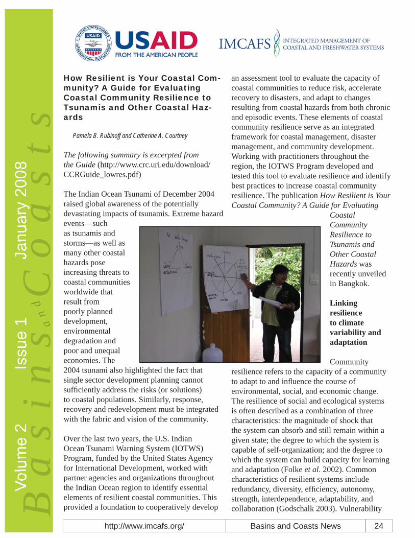
Pamela B. Rubinoff and Catherine A. Courtney
The following summary is excerpted from the Guide (http://www.crc.uri.edu/download/CCRGuide_lowres.pdf)
The Indian Ocean Tsunami of December 2004 raised global awareness of the potentially devastating impacts of tsunamis. Extreme hazard events—such as tsunamis and storms—as well as many other coastal hazards pose increasing threats to coastal communities worldwide that result from poorly planned development, environmental degradation and poor and unequal economies. The 2004 tsunami also highlighted the fact that single sector development planning cannot suffi ciently address the risks (or solutions) to coastal populations. Similarly, response, recovery and redevelopment must be integrated with the fabric and vision of the community.
Over the last two years, the U.S. Indian Ocean Tsunami Warning System (IOTWS) Program, funded by the United States Agency for International Development, worked with partner agencies and organizations throughout the Indian Ocean region to identify essential elements of resilient coastal communities. This provided a foundation to cooperatively develop
an assessment tool to evaluate the capacity of coastal communities to reduce risk, accelerate recovery to disasters, and adapt to changes resulting from coastal hazards from both chronic and episodic events. These elements of coastal community resilience serve as an integrated framework for coastal management, disaster management, and community development. Working with practitioners throughout the region, the IOTWS Program developed and tested this tool to evaluate resilience and identify best practices to increase coastal community resilience. The publication How Resilient is Your Coastal Community? A Guide for Evaluating
Coastal Community Resilience to Tsunamis and Other Coastal Hazards was recently unveiled in Bangkok.
Linking resilience to climate variability and adaptation
Community resilience refers to the capacity of a community to adapt to and infl uence the course of environmental, social, and economic change. The resilience of social and ecological systems is often described as a combination of three characteristics: the magnitude of shock that the system can absorb and still remain within a given state; the degree to which the system is capable of self-organization; and the degree to which the system can build capacity for learning and adaptation (Folke et al. 2002). Common characteristics of resilient systems include redundancy, diversity, effi ciency, autonomy, strength, interdependence, adaptability, and collaboration (Godschalk 2003). Vulnerability
Basins and Coasts Newshttp://www.imcafs.org/ 25
Volu
me
2Is
sue
1Ja
nuar
y 20
08B
as
in
sV
an
dC
oa
st
sis the fl ip side of resilience. When a social or ecological system loses resilience, it becomes vulnerable to change that previously could be absorbed (Kasperson and Kasperson 2001). In a resilient system, change has the potential to create opportunity for development, novelty, and innovation. In a vulnerable system, even small changes may be devastating.
The Coastal Community Resilience (CCR) Guide addresses coastal hazards and the impacts on coastal communities. In this case, climate variability is considered one of the drivers of coastal hazards that impacts coastal residents, economics and ecosystems. By assessing community strengths and weaknesses across eight elements of resilience, a community can identify existing adaptation measures in place and identify critical needs to incorporate new measures into coastal residents’ daily lives, and into government policies and private sector actions. When promoting increased coastal community resilience, it is critical to both consider chronic and episodic hazards. Climate variability can infl uence many types of hazards, which in turn signifi cantly impact coastal environments by causing an increase or decrease in storm activity. That in turn could lead to water supply issues, drought, or increased fl ooding and erosion. (IRG 2007).
Risk assessment is an important element of CCR. Economic development pressures along the coast, population density and distribution, and human-induced vulnerabilities, coupled with increasing frequency and duration of storms, sea level rise, and other chronic coastal hazards all serve to increase risk. Communities must identify their exposure to hazard impacts as a fi rst step toward proactively addressing emergency planning, response, and recovery and implementing hazard mitigation measures. Unfortunately, in many rural coastal communities such basic services as disaster warning systems and response mechanisms
are severely limited as is local capacity to plan for and respond to coastal hazards. This puts already vulnerable coastal populations at additional risk. And, while risk assessment and hazard management are essential in building a community’s resilience, they alone are not enough. “If we focus on needs and vulnerabilities, we remain locked in the logic of repetitive responses that fail to nurture the capacities for resilience contained deep within every community.” (IFRC 2004).
CCR Framework
The CCR Guide was built around lessons learned and experience gained in the Indian Ocean region during the aftermath of the 2004 tsunami—lessons about how to address coastal hazards, reduce future risks, increase the effectiveness of recovery, and adapt to changes within the community and the environment. A key lesson that emerged is that single-sector development planning cannot solve the complexity of problems posed by natural hazards nor build resilience to them. It requires working across sectors and with a wide array of groups and organizations. Resilience requires spreading the risk and developing integrated and holistic prevention and management programs. In this manner, unexpected changes can be absorbed more easily, so that disaster scenarios can be avoided whenever possible. The Guide encourages looking across three key domains—disaster management, coastal management and community development—to assess resilience in a holistic fashion.
The CCR framework was developed through a series of workshops and discussions with community development, coastal management, and disaster management practitioners and specialists from government agencies and NGOs throughout the Indian Ocean region. Through this participatory process, eight elements of resilience were identifi ed as essential for CCR.
Basins and Coasts Newshttp://www.imcafs.org/ 26
Volu
me
2Is
sue
1Ja
nuar
y 20
08B
as
in
sV
an
dC
oa
st
sLong-term planning and implementation issues are incorporated into the elements of society and economy, coastal management, land use and structural design. Hazard event-oriented resilience elements focus on contingency planning and preparedness for warning and evacuation, emergency response, and disaster recovery. The governance element is critical because it provides the enabling framework for all the other elements. However, enhancing resilience in all elements is essential to reduce risks from coastal hazards and accelerate recovery from disaster events.
Resilience Assessment
The assessment uses eight benchmarks to evaluate the capacity of a community to reduce risk, accelerate disaster recovery, and adapt to change from coastal hazards. The benchmarks for each resilience element characterize desired conditions in four core capacities: policy and planning, physical and natural resources, social and cultural, and technical and fi nancial. The CCR assessment process aims to identify both strengths and weaknesses in each resilience element. Highlighting the strengths will help communities better understand those existing assets that already contribute to resilience. Identifying the weaknesses will provide a better idea of the gaps that need to be closed in order to increase resilience. In piloting the assessment in Sri Lanka, Thailand and Indonesia, the CCR assessment tool proved itself a powerful mechanism that community stakeholders, together with government, nongovernmental organizations (NGO), and other stakeholders could use to begin enhancing resilience. One characteristic of resilient communities is that they learn from experience and adapt to change. Through the pilot assessments, practitioners engaged community members by encouraging them to tell stories about their tsunami experience. These stories revealed anecdotes about the resilience of individuals, families
and communities. In Thailand, community members said it was the King’s Self-Suffi ciency Philosophy that most motivated them to care for their community members in recovery.
Keeping the eight elements of resilience in the forefront during the assessment and planning process ensures a balanced approach for program implementation. For example, if a community is primarily concerned with minimizing the impacts of storm surge to which it is vulnerable, assessing the eight CCR elements will ensure that all the factors that can minimize the impact of storm surge are brought into the planning discussion. This may include identifi cation of evacuation routes, increased building standards, or relocation of activities to inland locations. A CCR assessment provides an opportunity to initiate dialogue among key stakeholders in the area. Similarly, the assessment provides opportunities for different groups (including NGO and government) to engage in identifying a suite of solutions. Dialogue is crucial to encourage the stakeholder community to recognize the need for better resilience and to better understand what forces need to be addressed to lessen the community’s vulnerability through planning.
The process described in the guide is intended as a rapid assessment. Ideally, it should be conducted by a multidisciplinary team that includes members experienced in community development, coastal management, and disaster management. In the Sri Lanka Case, the coastal managers of the Coastal Community Development Department asked the Disaster Management Center and a local NGO community leader to collaborate in their assessment of two coastal regions. This way different team members focused on specifi c aspects of the community, and discussed the fi ndings in a more holistic fashion. It also provided an opportunity for the practitioners to learn from their colleagues about the good

Basins and Coasts Newshttp://www.imcafs.org/ 27
Volu
me
2Is
sue
1Ja
nuar
y 20
08B
as
in
sV
an
dC
oa
st
spractices to increase resilience in another domain, mostly unfamiliar to them.
Putting it into Action
Resilient coastal communities plan for and take deliberate action to reduce risks from coastal hazards, accelerate recovery from disaster events, and adapt to changing conditions. The results of a CCR assessment will highlight many opportunities—at the national, sub-national, and local levels—to enhance resilience.
The most immediate use of the assessment results is to develop an action plan with strategies to fi ll gaps, address weaknesses, and sustain or replicate effective practices. In Sri Lanka, for example, the Coastal Community Development Department intends to incorporate their assessments within the action plan for their Special Area Management program. The CCR assessment can also serve as a focal point to engage the community and government and nongovernmental community members and local authorities, all of whom must
work together to plan for disaster prevention, mitigation and recovery. A participatory approach to action planning is essential to success, including ensuring the actions to be implemented are appropriate and realistic for the community.
References
Folke, C., J. Colding, and F. Berkes, editors. 1. 2002. “Synthesis: building resilience and adaptive capacity in social-ecological systems.” Navigating Social-ecological systems: Building resilience of complexity and change. Cambridge University Press.
Godschalk, David R. 2003. “Urban Hazard 2. Mitigation: Creating Resilient Cities.” Natural Hazards Review. Volume 4(3). Pages 136-143.
Holling, C. S. 1973. “Resilience and stability 3. of ecological systems.” Annual Review of Ecological Systems. Volume 4. Pages 1-23.
International Federation of the Red Cross and 4. Red Crescent Societies. 2004. World Disasters Report: A Focus on Community Resilience.
International Resources Group. 2007. 5. “Adapting to Climate Variability and Change.” Prepared through an Environmental Policy and Institutional Strengthening Indefi nite Quantities Contract task order with the U.S.AID, Bureau for Economic Growth, Agriculture and Trade, Contract No. EPP-I-00-03-00013-00.
Some Defi nitions of Resilience
“Resilience determines the persistence of relationships within a system and is a measure of the ability of these systems to absorb change of state….and still persist.” (Holling 1973)
“…Resilience for social-ecological systems is often referred to as related to three different characteristics: (a) the magnitude of shock that the system can absorb and remain within a given state; (b) the degree to whichthe system is capable of self-organization, and (c) the degree to which the system canbuild capacity for learning and adaptation.”(Folke et al. 2002)
“The capacity of a system to absorb disturbance and re-organize while undergoing change so as to still retain essentially the same function, structure, identity and feedback.” (Walker et al. 2004)
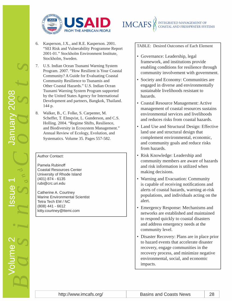
Basins and Coasts Newshttp://www.imcafs.org/ 28
Volu
me
2Is
sue
1Ja
nuar
y 20
08B
as
in
sV
an
dC
oa
st
sKasperson, J.X., and R.E. Kasperson. 2001. 6. “SEI Risk and Vulnerability Programme Report 2001-01.” Stockholm Environment Institute, Stockholm, Sweden.
U.S. Indian Ocean Tsunami Warning System 7. Program. 2007. “How Resilient is Your Coastal Community? A Guide for Evaluating Coastal Community Resilience to Tsunamis and Other Coastal Hazards.” U.S. Indian Ocean Tsunami Warning System Program supported by the United States Agency for International Development and partners, Bangkok, Thailand. 144 p.
Walker, B., C. Folke, S. Carpenter, M. 8. Scheffer, T. Elmqvist, L. Gunderson, and C.S. Holling. 2004. “Regime Shifts, Resilience, and Biodiversity in Ecosystem Management.” Annual Review of Ecology, Evolution, and Systematics. Volume 35. Pages 557-582.
TABLE: Desired Outcomes of Each Element
Governance: Leadership, legal • framework, and institutions provide enabling conditions for resilience through community involvement with government.Society and Economy: Communities are • engaged in diverse and environmentally sustainable livelihoods resistant to hazards.Coastal Resource Management: Active • management of coastal resources sustains environmental services and livelihoods and reduces risks from coastal hazards.Land Use and Structural Design: Effective • land use and structural design that complement environmental, economic, and community goals and reduce risks from hazards.Risk Knowledge: Leadership and • community members are aware of hazards and risk information is utilized when making decisions.Warning and Evacuation: Community • is capable of receiving notifi cations and alerts of coastal hazards, warning at-risk populations, and individuals acting on the alert.Emergency Response: Mechanisms and • networks are established and maintained to respond quickly to coastal disasters and address emergency needs at the community level.Disaster Recovery: Plans are in place prior • to hazard events that accelerate disaster recovery, engage communities in the recovery process, and minimize negative environmental, social, and economic impacts.
Author Contact:
Pamela RubinoffCoastal Resources CenterUniversity of Rhode Island(401) 874 - [email protected]
Catherine A. CourtneyMarine Environmental ScientistTetra Tech EM / NC(808) 441 - [email protected]

Basins and Coasts Newshttp://www.imcafs.org/ 29
Volu
me
2Is
sue
1Ja
nuar
y 20
08B
as
in
sV
an
dC
oa
st
sAdapting to Climate Change: It is Just Better Planning
Lynne Carter and Beth Raps
What is adaptation?
According to Merriam-Webster dictionary, the word ‘adapt’ and versions thereof (e.g., adapting, adaptation, adaptedness) mean ‘to change to better match present or future circumstances’. When used in talking about the humans and the changing environment, it can mean adjusting to environmental conditions to avoid negative impacts or can mean embracing positive consequences of change. Science tells us the climate is changing (e.g. temperatures and sea levels are rising and precipitation patterns are changing), and humans already know what it means to have our natural environment change and how to prepare for it through changes in our built environment. For example, changing seasons bring the need for different types of clothing for each; and different housing conditions are needed to accommodate different/changing weather conditions—e.g., cold winters and warm summers. Change, then, can and does affect us in both our natural environment and in our built or human environment. And knowledge around what is likely coming can help us prepare effectively and become less vulnerable to the impacts of this change. Unfortunately, the past can no longer serve us as a good guide to the future
Adaptations we make to climatic change need to focus on making systems more resilient and healthy not just for today but for the long term. Resilient, healthy systems can better withstand all types of perturbations than can systems that are unbalanced or at the edge of their survival. Making a system more resilient can mean: reducing pressures that are already stressing the system; fi shing for new species that are becoming established in a new region—
thereby reducing pressure on a stressed species; providing greenways and migration routes along which plants and animals can move to seek out their best-matched environment; or restoring natural fl oodways to allow the natural system to better protect the built environment. It can also mean investing in long-term projects that reduce rather than increase vulnerability (of people, infrastructure, or even investments) to climate change. It can mean investments in educating the public to increase their awareness of more environmentally friendly choices and options available to them.
Adaptations are always regional and local
Because climate change impacts are regionally and locally specifi c, adaptations to address those impacts must be similarly scaled. Unfortunately, at present most of the available climate change information and climate model projections are at large geographical scales. Until such appropriately downscaled information is available to all regions and localities, it is diffi cult to know what aspects of the present climate scenario are likely to change or continue in any one particular region. Coastal managers, for example, could wonder if recently experienced fl ooding from sea level rise might become a more regular event. With information on the relative rate of sea level rise in a specifi c area that manager could then better predict likely future scenarios.
Is it unwise to base decisions on how to adapt to future climatic conditions on extremely specifi c projected value(s)—for example, predicted temperature, precipitation, or sea-level rise—or tied to a specifi c future date. A more skillful approach is to look at the trends suggested by existing models along with the trends that are beginning to show themselves in the region in question and to plan accordingly. Trends will continue to change and emerge for generations to come—even should mitigation efforts be

Basins and Coasts Newshttp://www.imcafs.org/ 30
Volu
me
2Is
sue
1Ja
nuar
y 20
08B
as
in
sV
an
dC
oa
st
sextremely successful.
Trends are just one of the important factors in decision making. Another is vulnerability. Mapping both observed and projected trends against already identifi ed vulnerabilities helps identify where to start in terms of thinking through adaptation options. There are many approaches to selecting adaptive activities and each has its appropriate place in a planning repertoire. Such approaches include but are not limited to: scenario building, hazard planning, and what ifs/how much scenario building (would have to happen to see a particular negative impact or reach a threshold).
Who should consider adaptation activities? Decisions about adaptation are made at a range of levels. Cities and towns may look at areas of present vulnerability—for example, area where it always fl oods during heavy rains—and in response make changes to the drainage system in order to reduce such fl ooding. Meanwhile, states or regions may look to change laws or regulations that could, for example, lead to the development of improved long-term plans and systems (e.g. a reservoir, or infrastructural planning that includes likely climate projections in their tolerances, etc.). At the homeowner level, the decision might be to not plant traditional trees, shrubs, and plants but rather those that grow more readily in what is projected to be the environment of the future. Town citizens might work to develop neighborhood resiliency plans, while state and national agencies show their support for climate adaptation by offering grants to develop local models that refl ect the choices of local decision-makers.
Along with diverse levels of decision-makers, there are also a variety of time scales or timelines along which decisions can be made. The farmer who plants annual crops will
make decisions on a yearly basis, while those responsible for planning the development and implementation of a bridge or other long-lived infrastructure, e.g. a port, will need to plan for and across a much longer timeframe. Again, it is important to recognize that the future will be different from the past and include those future differences in any planning and hazard mitigation efforts.
Adaptation considerations
Short-term decisions must be consistent with the longer-term perspective of adaptation demands, and look to reduce societal vulnerability and build the resilience of natural systems. Making adaptations that address immediate problems but fail to translate into long-term solutions, or worse create new long-term problems, wastes time and money.
There are other considerations in any adaptation planning process:
After deciding on the need for an adaptive 1. action, consider the costs (both economic and in terms of who will be impacted).
What are the costs• Who should pay them• How should responsibility be shared, who • can helpAre there groups missing from the • discussion e.g. those likely impacted (vulnerable groups) or those who have expertise to assist in the process (corporations)? Equity issues might need to be included in your calculations as well as the costs of doing nothing.
What might be unintended or unexpected 2. consequences from the adaptive action? Think creatively and expansively and anticipate and address any possible problems.
What is the relationship between adaptations 3. that occur in different sectors? For example, an

Basins and Coasts Newshttp://www.imcafs.org/ 31
Volu
me
2Is
sue
1Ja
nuar
y 20
08B
as
in
sV
an
dC
oa
st
sadaptation that requires a release of water from a reservoir to deal with reduced runoff from lack of rain to support a fi shery could cause a water shortage for agriculture or human use.
Each adaptation action needs to consider the 4. relationship between adaptation and mitigation. Will the adaptation make mitigation harder or easier to attain? An adaptation to address heat stress might be to provide air conditioners to needy residents. While that action could address the health concerns that are generated when there are heat waves, that same action could also lead to problems in the energy sector—a sector already stressed on hot days—and could thereby worsen the overall problem for the longer term worse by increasing greenhouse gases emissions.
These and other considerations support the need for a signifi cant level of planning and feedback prior to and following implementation of any adaptive decision(s). Feedback can include evaluating the present success of the action and continuing such evaluations over time—i.e., as the “new” environment emerges. Adaptation is not new. Rather, it is about better planning and the use of different information (future projections) in recognition that the future will be different than the past. All adaptive actions should try to fall into the win-win-win category—where there is a benefi t now, a benefi t in the future, and potentially provide a benefi t whether or not the projected climate changes become reality.
The Adaptation Network is a non-profi t organization and a project of the Earth Island Institute. Its goal is to promote adaptation in concert with mitigation to build resilience in this changing climate. The Network never reinvents
the wheel. Where good work exists it is shared with others. Where work is still needed, the Network focuses its efforts. Emails are sent every three to four months to alert Network members to what is new in adaptation. To be added to the Network membership list, please email [email protected].
Author Contact:
Lynne M Carter, Ph.D.Beth Raps, Ph.D. Co-Directors, Adaptation Networkwww.adaptationnetwork.org

Basins and Coasts Newshttp://www.imcafs.org/ 32
Volu
me
2Is
sue
1Ja
nuar
y 20
08B
as
in
sV
an
dC
oa
st
sMore Information
USAID Global Climate Change Programhttp://www.usaid.gov/our_work/environment/climate
UN Website Gateway to the UN System’s Work on Climate Changehttp://www.un.org/climatechange/
Linking Climate Adaptation Networkwww.linkingclimateadaptation.org
Climate Action Network (CAN)www.climatenetwork.org
Tiempo Climate Newswatchwww.tiempocyberclimate.org
United Nations Framework Convention on Climate Changehttp://www.unfccc.int/2860.php
Adaptation Networkwww.adaptationnetwork.org
South Pacifi c Regional Environment Program (SPREP)http://www.sprep.org/climate_change/index.asp
Mainstreaming Adaptation to Climate Change (MACC) project, Caribbean Community Secretariat (CARICOM)http://www.caricom.org/jsp/projects/macc%20project/macc.jsp?menu=projects
Assessments of Impacts and Adaptations to Climate Change (AIACC)www.aiaccproject.org
Climate Change ResourcesNew Zealand Climate Change Offi ce (2004), “Coastal Hazards and Climate Change: A Guidance Manual for Local Government in New Zealand,” Ministry of Environment, Wellington, New Zealand, May 2004, 156 pp. (http://www.mfe.govt.nz/publications/climate/coastal-hazards-may04/coastal-hazards-may04.pdf)
Center for Science in the Earth System (2007), “Preparing for Climate Change: A Guidebook for Local, Regional and State Governments,” University of Washington and King County, Washington, 186 pp. (http://www.cses.washington.edu/cig/fpt/guidebook.shtml)
Heinz Center (2007), “A Survey of Climate Change Adaptation Planning,” The H. John Heinz III Center for Science, Economics and the Environment, Washington, D.C., 52 pp. (http://www.hein-zctr.org/NEW_WEB/PDF/Adaptation_Report_October_10_2007.pdf)
Clean Air Partnership (2007), “Cities Preparing for Climate Change: A Study of Six Urban Regions,” Clean Air Partnership (CAP), Toronto, Canada, May 2007, 74 pp. (http://www.cleanairpartnership.org/pdf/cities_climate_change.pdf)
Tyndall (2005), “Surviving Climate Change on Small Islands: A Guidebook,” Tyndall Center for Climate Change Research, Norwich, UK, October 2005, 128 pp. (http://www.tyndall.ac.uk/publica-tions/surviving.pdf)
FAO (2006), “Building Adaptive Capacity to Climate Change: Policies to Sustain Livelihoods and Fisheries,” United Nations Food and Agriculture Organization, New Directions in Fisheries – A Series of Policy Briefs on Development Issues, No. 08, Rome, 12 pp. (www.sfl p.org/briefs/eng/07.pdf)
IIED (2003), “Mainstreaming Adaptation to Climate Change in Least Developed Countries,” Inter-national Institute for Environment and Development, London, April 2003, 42 pp. (www.un.org/special-rep/ohrlls/ldc/LDCsreport.pdf)

Basins and Coasts Newshttp://www.imcafs.org/ 33
Volu
me
2Is
sue
1Ja
nuar
y 20
08B
as
in
sV
an
dC
oa
st
sAdger, N. et al. (2003), “Adaptation to Climate Change in the Developing World,” Progress in De-velopment Studies, Vol. 3, No. 3, pp. 179-195 (www.uea.ac.uk/env/people/adgerwn/ProgDevStud-ies2003.pdf)
Australian Government (2005), “Climate Change Risk and Vulnerability: Promoting an Effi cient Adaptation Response in Australia,” Department of Environment and Heritage, Australian Green-house Offi ce, March 2005, 159 pp. (http://www.greenhouse.gov.au/impacts/publications/pubs/risk-vulnerability.pdf)
Allison, E., W. Adger, et al. (2005), “Effects of Climate Change on the Sustainability of Capture and Enhancement fi sheries Important to the Poor: Analysis of the Vulnerability and Adaptability of Fisherfolk Living in Poverty,” Fisheries Management Science Programme, London, September 2005, 167 pp. (www.fmsp.org.uk)
SPREP (2006), “CV&A: A Guide to Community Vulnerability and Adaptation Assessment and Ac-tion,” South Pacifi c Regional Environment Program, 47 pp. (http://www.sprep.org/climate_change/index.asp)
AIACC, “AIACC Final Reports,” Assessments of Impacts and Adaptations to Climate Change (AIACC), (http://www.aiaccproject.org/Final%20Reports/fi nal_reports.html)
AIACC, “AIACC Working Paper Series” Assessments of Impacts and Adaptations to Climate Change (AIACC), (http://www.aiaccproject.org/working_papers/working_papers.html)
University of Hawaii Sea Grant (2007), “Homeowners’ Handbook to Prepare for Natural Hazards,” June, 2007, 108 pp. (http://www.hawaii.gov/dlnr/occl/)AIACC (2007), “A Stitch in Time: Lessons for Climate Change Adaptation from the AIACC Project,” Assessments of Impacts and Adaptations to Climate Change (AIACC), Working Paper Number 38, May 2007, 23 pp. (http://www.aiaccproject.org/working_papers/working_papers.html)
ConferencesJanuary 24-25, 2008, Fourth Austrian JI/CDM Workshop hosted in Vienna, Austria, addressing Joint Implementation (JI) and the Clean Development Mechanism (CDM) under the Kyoto proto-col. (http://www.ji-cdm-austria.at/en/portal/index.php)
February 7-8, 2008, conference on “Living with climate change: are there limits to adaptation?” at the Royal Geographical Society, London. Organized by the Tyndall Centre for Climate Change Re-search and the University of Oslo, with the support of the Global Environment Change and Human Security project (http://www.tyndall.ac.uk/research/programme3/adaptation2008/index.html)
February 7-9, 2008, Delhi Sustainable Development Summit on “Sustainable Development and Climate Change.” Organized by The Energy and Resources Institute (TERI), this summit will take place in New Delhi, India. (http://www.teriin.org/dsds/2008)
March 4-6, 2008, the “Washington International Renewable Energy Conference 2008” will be held in Washington, D.C., USA. (http://www.wirec2008.org)
March 11-13, 2008, Oceanology International 2008 Conference on “Technology, sustainability and the oceans,” in London, UK. (http://www.imarest.org/events/oceanology/)
April 2-4, 2008, meeting on “Food Security and Environmental Change: Linking Science, Develop-ment and Policy for Adaptation.” Organized by Global Environmental Change and Food Systems, this meeting will be held at the University of Oxford, UK. (http://www.foodsecurity.elsevier.com)
April 9-10, 2008, “28th Session of the Intergovernmental Panel on Climate Change.” This meeting is tentatively scheduled to be held in Budapest, Hungary. (http://www.ipcc.ch)
April 7-11, 2008, conference on “Oceans, coasts and islands: advancing ecosystem management and integrated coastal and ocean management by 2010 in the context of climate change,” in Ha-noi, Vietnam. (http://www.globaloceans.org/globalconferences/2008/index.html)

Basins and Coasts Newshttp://www.imcafs.org/ 34
Volu
me
2Is
sue
1Ja
nuar
y 20
08B
as
in
sV
an
dC
oa
st
sApril 14-17 2008, international science and policy conference on “RESILIENCE 2008 - Resilience, adaptation and transformation in turbulent times,” in Stockholm, Sweden. (http://resilience2008.org/index.htm)
April 21-24, 2008, workshop for young marine scientists on “Climate driving of marine ecosys-tems changes,” in Brest, France. Organized by the European Institute for Marine Studies (IUEM). (http://www.imber.info/CLIMECO_home.html)
May 10-13, 2008, “International workshop on evaluating climate change and development,” in Alexandria, Egypt. Organized by the Evaluation Offi ce of the Global Environment Facility (www.esdevaluation.org)
May 19-23, 2008, conference on “Effects of climate change on the world oceans,” in Gijón, Spain. (http://www.pices.int/meetings/international_symposia/2008_symposia/Climate_change/climate_background_3.aspx)
June 2-13. 2008, the “28th Sessions of the UNFCCC Subsidiary Bodies: The 28th sessions of the Subsidiary Bodies of the UN Framework Convention in Climate Change (UNFCCC) – the Subsidiary Body for Implementation (SBI) and the Subsidiary Body for Scientifi c and Technological Advice (SBSTA) are scheduled to be held in Bonn, Germany. (http://unfccc.int/meetings/unfccc_calendar/items/2655.php?year=2008)
July 8-11, 2008, symposium on “Coping with global change in marine social-ecological systems,” in Rome, Italy. Co-organized by the Food and Agriculture Organization. (http://www.peopleandfi sh.org)
September 1-12, 2008, interactive short course on “Climate Change and Development,” at the Overseas Development Group, University of East Anglia, United Kingdom (http://www1.uea.ac.uk/cm/home/schools/ssf/dev/odg/prodev/ccd)
October 15-19, 2008, conference on “Social challenges of global change,” in New Delhi, India. Or-ganized by the International Human Dimensions Program on Global Environment Change and the Energy and Resources Institute (www.openmeeting2008.org)
November 26-28, 2008, 4th international conference and exhibition on “Consequences of climate change and fl ood protection,” in Hamburg, Germany. (www.acqua-alta.de)
Theme for Volume 2 Issue 2
The theme for the next issue of Basins and Coasts is “Paying for Ecosystem Services” within the context of river basin and coastal management in developing countries. We would like suggestions from readers along with examples of and case studies on the valuation of and payment for ecosystem services. Send your ideas to [email protected].
About Basins and Coasts
Basins and Coasts is the newsletter for the USAID Integrated Management of Coastal and Freshwater Systems Program, which features two separate but collaborative programs. The IMCAFS-SUCCESS program (Sustainable Coastal Communities and Ecosystems) emphasizes coastal resources, aquaculture and fi sheries management (http://www.crc.uri.edu/SUCCESS/). The IMCAFS-GLOWS program (Global Water for Sustainability) focuses on integrated management of freshwater resources (http://globalwaters.net). The newsletter team is: Elizabeth Anderson, Bob Bowen, Don Robadue, and Lesley Squillante. You can reach us at [email protected].