Embed Size (px)
Citation preview
31Project context
4 Project context
The location of the proposed bridge over the river influences the route for the approach roads and their relationship to the existing urban fabric, physical structure and experience of the Grafton area by residents and tourists. This chapter provides an identification and discussion of the key landscape and urban design factors that are likely to be affected by the location of the proposed bridge and approach roads in Grafton and South Grafton. This discussion will be the basis for understanding how the Objectives and Principles were developed for the project that are described in Chapter 5.
The key aspects of the project area that are likely to influence the urban and landscape design of the project and help define the landscape character include:
• river setting• Aboriginal heritage and cultural values• Non-Aboriginal heritage and cultural values• Vegetation and habitat• Urban character and landscape• Recreational values of the Clarence River• Arrival points• Activity generators• Pedestrian and cyclist connectivity• Property and built form.
These are discussed in the following sections.

32 ADDITIONAL CROSSING OF THE CLARENCE RIVER AT GRAFTON | URBAN DESIGN AND LANDSCAPE CONCEPT REPORT (INCLUDING LANDSCAPE CHARACTER AND VISUAL IMPACT ASSESSMENT)
RIVER SETTINGThe strong connection between the main streets and the riverfront is a distinguishing characteristic of both Grafton and South Grafton’s town centres. Both Prince Street and Skinner Street lead directly to the primary riverfront public spaces on either side of the Clarence River. Skinner Street also leads directly to the section of the river between Susan Island and Grafton Bridge, which is the primary recreational and special event space for Grafton.
The visual relationship between Grafton and the Clarence River is fundamental to the urban experience of the town and is illustrated in Figure 4.1. This vital relationship is clearly identified and supported by the Clarence River Way Masterplan (2009), which refers to Grafton as the “River City” and aims to further develop the public recreational values of the riverfront between the existing bridge and Susan Island.
East (downstream) of Grafton Bridge, the relationship between the city and the river has a much less public focus. Residential properties occupy much of the river’s northern frontage and public access is limited to the ends of the streets that lead down to the river. On the southern side of the river, the area east of the bridge is occupied by private agricultural land.
As the dominant visual feature on the Clarence River, Grafton Bridge is a key urban landmark that contributes significantly to the identity of the town. There are two primary types of views to the bridge: proximate views from the riverfront public spaces at Grafton and South Grafton, and long range views from elevated vantage points throughout the district, primarily south of the Clarence River.
The views of the town from the bridge are also an important component of the urban experience of Grafton, providing a strong visual sense of the relationship between the town and the Clarence River. The best views from the bridge of the river and the adjoining foreshores are from the two pedestrian and cyclist paths, located at the rail deck level on either side of the bridge. The views from the train are partially screened by the bridge’s steel trusses, and the motorists’ views from the road deck level are partially obscured by the bridge parapet.
4.1 PROPOSED BRIDGE AND APPROACH ROAD CONTEXT
Figure 4.1: Key view points from Grafton and South Grafton of the existing bridge in the context of the proposed project
12
3
45
6
Gwydir HighwayA
rmid
ale
Stre
etPacific Highway
Bent
Str
eet
Prin
ce S
treetPound Street
Skin
ner
Stre
et
Oliver Street
Dobie Street
Mar
low
Str
eet
North Street
Sum
mer
land
Way
Cen
tena
ry D
rive
Villie
rs S
treet
Grafton Bridge
Grafton Station
SOUTHGRAFTON
GRAFTON
CARRS ISLAND
SUSAN ISLANDNATURE RESERVE
SOUTH GRAFTON
AERODROME
Que
en S
treet
Pacific
High
way
Gwydir Highway SUSANISLAND
ELIZABETHISLAND
0 500 1,000250Metres
Gwydir Highway
Arm
idal
e St
reet
Pacific Highway
Bent
Str
eet
Prin
ce S
treetPound Street
Skin
ner
Stre
et
Oliver Street
Dobie Street
Mar
low
Str
eet
North Street
Sum
mer
land
Way
Cen
tena
ry D
rive
Villie
rs S
treet
Grafton Bridge
Grafton Station
SOUTHGRAFTON
GRAFTON
CARRS ISLAND
SUSAN ISLANDNATURE RESERVE
SOUTH GRAFTON
AERODROME
Que
en S
treet
Pacific
High
way
Gwydir Highway SUSANISLAND
ELIZABETHISLAND
0 500 1,000250MetresDirect view point
Distant view point
Existing RMS Regional Coastline Cycleway Route
High Archaeological PotentialModerate Archaeological Potential
SILEP_LZNZONE_
B1
B2
B3
B4
B5
B6
B7
B8
DM
E1
E2
E3
E4
IN1
IN2
IN3
IN4
MD
R1
R2
R3
R4
R5
RE1
RE2
RU1
RU2
RU3
RU4
RU5
RU6
SP1
SP2
SP3
UL
W1
W2
W3
Town Centre
Established Residential
Industrial
Rural Hinterland
Major RetailCommercial and RetailEducation
Public park
Riverfront Parkland
Street Tree
Main Street
River ConnectionReedland (EEC)Remnant eucalypt (EEC)Melaleuca plantationNative and exotic plantingNative revegetationPlanted figWeeds and exotic
Degraded riparian forest (EEC)Potential drainage soak (EEC)
Hollow-bearing treeRecorded threatened fauna species
Primary River Recreation Area
NSW Maritime Navigable Channel
Navigable Extend (For 8.5m Tall Boats)
Grafton Waterfront Precinct
Impacted property likely to be fully aquiredImpacted property likely to be partially aquired
Proposed RMS Regional Coastline Cycleway Route
Heritage Item Identified During Project Investigations
Low Archaeological PotentialArchaeological Sites
CVLEP 2011 Heritage Conservation AreaCVLEP 2011 Heritage Listed Items CVLEP 2011 Heritage Listed Significant Tree
State Register Heritage Listed Items
National Trust Listed Items
Proposed CVC Recreational/Off-road Route
Major Local Route
National HIghway
State Route
Heavy Vehicle Diversion Route
Local Road
Arrival Point
Project BoundaryConcept DesignConstruction Work Zone
Cla
renc
e R
iver
Alipou Creek

33Project context
View from Grafton levee
View from Girl Guide Park
View from Through Street
View from Fitzroy Street, at sailing club
View from end of Skinner Street
View from Centenary Drive, Clarenza
1
3
5
2
4
6

34 ADDITIONAL CROSSING OF THE CLARENCE RIVER AT GRAFTON | URBAN DESIGN AND LANDSCAPE CONCEPT REPORT (INCLUDING LANDSCAPE CHARACTER AND VISUAL IMPACT ASSESSMENT)
ABORIGINAL HERITAGE AND CULTURAL VALUESThe Clarence River and the mouth of the Alipou Creek have been identified by the local Aboriginal community as having strong Aboriginal cultural values which need to be recognised and protected. Specifically, Alipou Creek and the Golden Eel site hold great significance to the Aboriginal community. Site investigations have identified that the project is located in areas of low archaeological potential in Grafton and South Grafton; these are shown on Figure 4.2.
Ensuring that the South Grafton side of the proposed bridge and approach roads are sensitively integrated into this highly valued cultural landscape will be an important consideration in the urban design of the project.
Existing RMS Regional Coastline Cycleway Route
High Archaeological PotentialModerate Archaeological Potential
SILEP_LZNZONE_
B1
B2
B3
B4
B5
B6
B7
B8
DM
E1
E2
E3
E4
IN1
IN2
IN3
IN4
MD
R1
R2
R3
R4
R5
RE1
RE2
RU1
RU2
RU3
RU4
RU5
RU6
SP1
SP2
SP3
UL
W1
W2
W3
Town Centre
Established Residential
Industrial
Rural Hinterland
Major RetailCommercial and RetailEducation
Public park
Riverfront Parkland
Street Tree
Main Street
River ConnectionReedland (EEC)Remnant eucalypt (EEC)Melaleuca plantationNative and exotic plantingNative revegetationPlanted figWeeds and exotic
Degraded riparian forest (EEC)Potential drainage soak (EEC)
Hollow-bearing treeRecorded threatened fauna species
Primary River Recreation Area
NSW Maritime Navigable Channel
Navigable Extend (For 8.5m Tall Boats)
Grafton Waterfront Precinct
Impacted property likely to be fully aquiredImpacted property likely to be partially aquired
Proposed RMS Regional Coastline Cycleway Route
Heritage Item Identified During Project Investigations
Low Archaeological PotentialArchaeological Sites
CVLEP 2011 Heritage Conservation AreaCVLEP 2011 Heritage Listed Items CVLEP 2011 Heritage Listed Significant Tree
State Register Heritage Listed Items
National Trust Listed Items
Proposed CVC Recreational/Off-road Route
Major Local Route
National HIghway
State Route
Heavy Vehicle Diversion Route
Local Road
Arrival Point
Project BoundaryConcept DesignConstruction Work Zone
Figure 4.2: Aboriginal heritage in the context of the proposed project
Gwydir Highway
Bent
Str
eet
Skin
ner
Stre
et
Villie
rs S
treet
GraftonBridge
SOUTHGRAFTON
GRAFTON
Kent
Stre
et
Breim
ba S
treet
Pacific Highway
Brom
ley S
treet
Clar
ence
Stre
et
Summerland Way
Greaves Street
Pound Street
Bacon Street
Oliver StreetFitzroy StreetVictoria Street
Prin
ce S
treet
Duk
e St
reet
Iola
nthe
Str
eet
Wha
rf St
reet
Through Street
Spring Street
Abb
ott S
tree
t
Cow
an S
tree
t
Vere Street
Metres0 200 400100
Existing RMS Regional Coastline Cycleway Route
High Archaeological PotentialModerate Archaeological Potential
SILEP_LZNZONE_
B1
B2
B3
B4
B5
B6
B7
B8
DM
E1
E2
E3
E4
IN1
IN2
IN3
IN4
MD
R1
R2
R3
R4
R5
RE1
RE2
RU1
RU2
RU3
RU4
RU5
RU6
SP1
SP2
SP3
UL
W1
W2
W3
Town Centre
Established Residential
Industrial
Rural Hinterland
Major RetailCommercial and RetailEducation
Public park
Riverfront Parkland
Street Tree
Main Street
River ConnectionReedland (EEC)Remnant eucalypt (EEC)Melaleuca plantationNative and exotic plantingNative revegetationPlanted figWeeds and exotic
Degraded riparian forest (EEC)Potential drainage soak (EEC)
Hollow-bearing treeRecorded threatened fauna species
Primary River Recreation Area
NSW Maritime Navigable Channel
Navigable Extend (For 8.5m Tall Boats)
Grafton Waterfront Precinct
Impacted property likely to be fully aquiredImpacted property likely to be partially aquired
Proposed RMS Regional Coastline Cycleway Route
Heritage Item Identified During Project Investigations
Low Archaeological PotentialArchaeological Sites
CVLEP 2011 Heritage Conservation AreaCVLEP 2011 Heritage Listed Items CVLEP 2011 Heritage Listed Significant Tree
State Register Heritage Listed Items
National Trust Listed Items
Proposed CVC Recreational/Off-road Route
Major Local Route
National HIghway
State Route
Heavy Vehicle Diversion Route
Local Road
Arrival Point
Project BoundaryConcept DesignConstruction Work Zone
Claren
ce R
iver
Alipou Creek

35Project context
NON ABORIGINAL HERITAGE AND CULTURAL VALUESThere are a range of non-Aboriginal heritage and associated cultural values to be considered as part of the proposed bridge and approach roads. The majority of the developed urban area in Grafton and South Grafton is located within a heritage conservation area, as is illustrated on Figure 4.3. Grafton is also the ‘Jacaranda City’ and hosts the annual Jacaranda Festival which is a major tourism attraction to the Grafton area.
Most of the potential impacts of the project on non-Aboriginal heritage items are located in Grafton. These items are of local heritage significance and include:
• The TAFE and two residential properties on Pound Street would be indirectly and directly impacted by the project
• The rail viaduct where it crosses Pound Street would be directly impacted by the project
• Several residential properties in the Kent/Greaves Street area would be directly impacted by the project
• A number of heritage listed tree species, specifically jacarandas and figs would be directly impacted by the project.
In contrast, there are no areas of listed heritage value in South Grafton that will be directly affected as part of the proposed bridge and approach roads. Site investigations for the project identified the train car turntable, near the Sugar Loading Facility, as having heritage value and it could be partially impacted by the project. Otherwise, the nearest listed heritage item is Grafton Station and the existing Grafton Bridge, which are both State heritage listed items.
Careful consideration of the heritage values in both Grafton and South Grafton will need to be carefully integrated into the project, in particular the visual relationship between the proposed bridge and the existing State heritage listed bridge.
Existing RMS Regional Coastline Cycleway Route
High Archaeological PotentialModerate Archaeological Potential
SILEP_LZNZONE_
B1
B2
B3
B4
B5
B6
B7
B8
DM
E1
E2
E3
E4
IN1
IN2
IN3
IN4
MD
R1
R2
R3
R4
R5
RE1
RE2
RU1
RU2
RU3
RU4
RU5
RU6
SP1
SP2
SP3
UL
W1
W2
W3
Town Centre
Established Residential
Industrial
Rural Hinterland
Major RetailCommercial and RetailEducation
Public park
Riverfront Parkland
Street Tree
Main Street
River ConnectionReedland (EEC)Remnant eucalypt (EEC)Melaleuca plantationNative and exotic plantingNative revegetationPlanted figWeeds and exotic
Degraded riparian forest (EEC)Potential drainage soak (EEC)
Hollow-bearing treeRecorded threatened fauna species
Primary River Recreation Area
NSW Maritime Navigable Channel
Navigable Extend (For 8.5m Tall Boats)
Grafton Waterfront Precinct
Impacted property likely to be fully aquiredImpacted property likely to be partially aquired
Proposed RMS Regional Coastline Cycleway Route
Heritage Item Identified During Project Investigations
Low Archaeological PotentialArchaeological Sites
CVLEP 2011 Heritage Conservation AreaCVLEP 2011 Heritage Listed Items CVLEP 2011 Heritage Listed Significant Tree
State Register Heritage Listed Items
National Trust Listed Items
Proposed CVC Recreational/Off-road Route
Major Local Route
National HIghway
State Route
Heavy Vehicle Diversion Route
Local Road
Arrival Point
Project BoundaryConcept DesignConstruction Work Zone
Figure 4.3: non Aboriginal heritage in the context of the proposed project
Gwydir Highway
Bent
Str
eet
Skin
ner
Stre
et
Villie
rs S
treet
GraftonBridge
SOUTHGRAFTON
GRAFTON
Kent
Stre
et
Breim
ba S
treet
Pacific Highway
Brom
ley S
treet
Clar
ence
Stre
et
Summerland Way
Greaves Street
Pound Street
Bacon Street
Oliver StreetFitzroy StreetVictoria Street
Prin
ce S
treet
Duk
e St
reet
Iola
nthe
Str
eet
Wha
rf St
reet
Through Street
Spring Street
Abb
ott S
tree
t
Cow
an S
tree
t
Vere Street
Metres0 200 400100
Existing RMS Regional Coastline Cycleway Route
High Archaeological PotentialModerate Archaeological Potential
SILEP_LZNZONE_
B1
B2
B3
B4
B5
B6
B7
B8
DM
E1
E2
E3
E4
IN1
IN2
IN3
IN4
MD
R1
R2
R3
R4
R5
RE1
RE2
RU1
RU2
RU3
RU4
RU5
RU6
SP1
SP2
SP3
UL
W1
W2
W3
Town Centre
Established Residential
Industrial
Rural Hinterland
Major RetailCommercial and RetailEducation
Public park
Riverfront Parkland
Street Tree
Main Street
River ConnectionReedland (EEC)Remnant eucalypt (EEC)Melaleuca plantationNative and exotic plantingNative revegetationPlanted figWeeds and exotic
Degraded riparian forest (EEC)Potential drainage soak (EEC)
Hollow-bearing treeRecorded threatened fauna species
Primary River Recreation Area
NSW Maritime Navigable Channel
Navigable Extend (For 8.5m Tall Boats)
Grafton Waterfront Precinct
Impacted property likely to be fully aquiredImpacted property likely to be partially aquired
Proposed RMS Regional Coastline Cycleway Route
Heritage Item Identified During Project Investigations
Low Archaeological PotentialArchaeological Sites
CVLEP 2011 Heritage Conservation AreaCVLEP 2011 Heritage Listed Items CVLEP 2011 Heritage Listed Significant Tree
State Register Heritage Listed Items
National Trust Listed Items
Proposed CVC Recreational/Off-road Route
Major Local Route
National HIghway
State Route
Heavy Vehicle Diversion Route
Local Road
Arrival Point
Project BoundaryConcept DesignConstruction Work Zone
Claren
ce R
iver
Alipou Creek

36 ADDITIONAL CROSSING OF THE CLARENCE RIVER AT GRAFTON | URBAN DESIGN AND LANDSCAPE CONCEPT REPORT (INCLUDING LANDSCAPE CHARACTER AND VISUAL IMPACT ASSESSMENT)
VEGETATION AND HABITATThe developed parts of the Grafton area are relatively urbanised. A variety of different tree species and vegetation communities provide habitat for a broad variety of species, including a number of threatened species that have been recorded in the area.
The foreshore of the Clarence River and Alipou Creek provide a range of different vegetation communities. Whilst most of this foreshore area contains weeds and exotic species, there are locations where recognised culturally important trees, such as jacaranda and flame trees, have established themselves. These contribute to the overall character of the area.
Minimising impacts on the local biodiversity and recognised culturally important trees will need to be carefully considered as part of the project. Opportunities to incorporate culturally important trees into the landscape design should also be considered.
Existing RMS Regional Coastline Cycleway Route
High Archaeological PotentialModerate Archaeological Potential
SILEP_LZNZONE_
B1
B2
B3
B4
B5
B6
B7
B8
DM
E1
E2
E3
E4
IN1
IN2
IN3
IN4
MD
R1
R2
R3
R4
R5
RE1
RE2
RU1
RU2
RU3
RU4
RU5
RU6
SP1
SP2
SP3
UL
W1
W2
W3
Town Centre
Established Residential
Industrial
Rural Hinterland
Major RetailCommercial and RetailEducation
Public park
Riverfront Parkland
Street Tree
Main Street
River ConnectionReedland (EEC)Remnant eucalypt (EEC)Melaleuca plantationNative and exotic plantingNative revegetationPlanted figWeeds and exotic
Degraded riparian forest (EEC)Potential drainage soak (EEC)
Hollow-bearing treeRecorded threatened fauna species
Primary River Recreation Area
NSW Maritime Navigable Channel
Navigable Extend (For 8.5m Tall Boats)
Grafton Waterfront Precinct
Impacted property likely to be fully aquiredImpacted property likely to be partially aquired
Proposed RMS Regional Coastline Cycleway Route
Heritage Item Identified During Project Investigations
Low Archaeological PotentialArchaeological Sites
CVLEP 2011 Heritage Conservation AreaCVLEP 2011 Heritage Listed Items CVLEP 2011 Heritage Listed Significant Tree
State Register Heritage Listed Items
National Trust Listed Items
Proposed CVC Recreational/Off-road Route
Major Local Route
National HIghway
State Route
Heavy Vehicle Diversion Route
Local Road
Arrival Point
Project BoundaryConcept DesignConstruction Work Zone
Figure 4.4: Vegetation and habitat in the context of the proposed project
Gwydir Highway
Bent
Str
eet
Skin
ner
Stre
et
Villie
rs S
treet
GraftonBridge
SOUTHGRAFTON
GRAFTON
Kent
Stre
et
Breim
ba S
treet
Pacific Highway
Brom
ley S
treet
Clar
ence
Stre
et
Summerland Way
Greaves Street
Pound Street
Bacon Street
Oliver StreetFitzroy StreetVictoria Street
Prin
ce S
treet
Duk
e St
reet
Iola
nthe
Str
eet
Wha
rf St
reet
Through Street
Spring Street
Abb
ott S
tree
t
Cow
an S
tree
t
Vere Street
Metres0 200 400100
Existing RMS Regional Coastline Cycleway Route
High Archaeological PotentialModerate Archaeological Potential
SILEP_LZNZONE_
B1
B2
B3
B4
B5
B6
B7
B8
DM
E1
E2
E3
E4
IN1
IN2
IN3
IN4
MD
R1
R2
R3
R4
R5
RE1
RE2
RU1
RU2
RU3
RU4
RU5
RU6
SP1
SP2
SP3
UL
W1
W2
W3
Town Centre
Established Residential
Industrial
Rural Hinterland
Major RetailCommercial and RetailEducation
Public park
Riverfront Parkland
Street Tree
Main Street
River ConnectionReedland (EEC)Remnant eucalypt (EEC)Melaleuca plantationNative and exotic plantingNative revegetationPlanted figWeeds and exotic
Degraded riparian forest (EEC)Potential drainage soak (EEC)
Hollow-bearing treeRecorded threatened fauna species
Primary River Recreation Area
NSW Maritime Navigable Channel
Navigable Extend (For 8.5m Tall Boats)
Grafton Waterfront Precinct
Impacted property likely to be fully aquiredImpacted property likely to be partially aquired
Proposed RMS Regional Coastline Cycleway Route
Heritage Item Identified During Project Investigations
Low Archaeological PotentialArchaeological Sites
CVLEP 2011 Heritage Conservation AreaCVLEP 2011 Heritage Listed Items CVLEP 2011 Heritage Listed Significant Tree
State Register Heritage Listed Items
National Trust Listed Items
Proposed CVC Recreational/Off-road Route
Major Local Route
National HIghway
State Route
Heavy Vehicle Diversion Route
Local Road
Arrival Point
Project BoundaryConcept DesignConstruction Work Zone
Claren
ce R
iver
Alipou Creek

37Project context
URBAN CHARACTER AND LANDSCAPEThere are a number of distinct landscape character types in Grafton, each distinguished by its particular combination of land use, topography and built form. The relationship between these landscape character types is an important aspect of the urban experience of the town. Based on site assessment and desktop review, the primary landscape character types in Grafton that are likely to be affected by the project are:
• the clarence river
• The two town centres of Grafton and South Grafton, which form the civic and commercial urban cores on either side of the river
• The established residential areas immediately connected to the town centres, with housing stock of varying ages
• Industrial areas generally situated along primary regional transport routes and on the outskirts of town
• The rural hinterland, consisting of low-lying river floodplain and rolling hills, with intermittent buildings in the landscape.
Existing RMS Regional Coastline Cycleway Route
High Archaeological PotentialModerate Archaeological Potential
SILEP_LZNZONE_
B1
B2
B3
B4
B5
B6
B7
B8
DM
E1
E2
E3
E4
IN1
IN2
IN3
IN4
MD
R1
R2
R3
R4
R5
RE1
RE2
RU1
RU2
RU3
RU4
RU5
RU6
SP1
SP2
SP3
UL
W1
W2
W3
Town Centre
Established Residential
Industrial
Rural Hinterland
Major RetailCommercial and RetailEducation
Public park
Riverfront Parkland
Street Tree
Main Street
River ConnectionReedland (EEC)Remnant eucalypt (EEC)Melaleuca plantationNative and exotic plantingNative revegetationPlanted figWeeds and exotic
Degraded riparian forest (EEC)Potential drainage soak (EEC)
Hollow-bearing treeRecorded threatened fauna species
Primary River Recreation Area
NSW Maritime Navigable Channel
Navigable Extend (For 8.5m Tall Boats)
Grafton Waterfront Precinct
Impacted property likely to be fully aquiredImpacted property likely to be partially aquired
Proposed RMS Regional Coastline Cycleway Route
Heritage Item Identified During Project Investigations
Low Archaeological PotentialArchaeological Sites
CVLEP 2011 Heritage Conservation AreaCVLEP 2011 Heritage Listed Items CVLEP 2011 Heritage Listed Significant Tree
State Register Heritage Listed Items
National Trust Listed Items
Proposed CVC Recreational/Off-road Route
Major Local Route
National HIghway
State Route
Heavy Vehicle Diversion Route
Local Road
Arrival Point
Project BoundaryConcept DesignConstruction Work Zone
Figure 4.5: Urban character areas in the context of the proposed project
Gwydir Highway
Bent
Str
eet
Skin
ner
Stre
et
Villie
rs S
treet
GraftonBridge
SOUTHGRAFTON
GRAFTON
Kent
Stre
et
Breim
ba S
treet
Pacific Highway
Brom
ley S
treet
Clar
ence
Stre
et
Summerland Way
Greaves Street
Pound Street
Bacon Street
Oliver StreetFitzroy StreetVictoria Street
Prin
ce S
treet
Duk
e St
reet
Iola
nthe
Str
eet
Wha
rf St
reet
Through Street
Spring Street
Abb
ott S
tree
t
Cow
an S
tree
t
Vere Street
Metres0 200 400100
Existing RMS Regional Coastline Cycleway Route
High Archaeological PotentialModerate Archaeological Potential
SILEP_LZNZONE_
B1
B2
B3
B4
B5
B6
B7
B8
DM
E1
E2
E3
E4
IN1
IN2
IN3
IN4
MD
R1
R2
R3
R4
R5
RE1
RE2
RU1
RU2
RU3
RU4
RU5
RU6
SP1
SP2
SP3
UL
W1
W2
W3
Town Centre
Established Residential
Industrial
Rural Hinterland
Major RetailCommercial and RetailEducation
Public park
Riverfront Parkland
Street Tree
Main Street
River ConnectionReedland (EEC)Remnant eucalypt (EEC)Melaleuca plantationNative and exotic plantingNative revegetationPlanted figWeeds and exotic
Degraded riparian forest (EEC)Potential drainage soak (EEC)
Hollow-bearing treeRecorded threatened fauna species
Primary River Recreation Area
NSW Maritime Navigable Channel
Navigable Extend (For 8.5m Tall Boats)
Grafton Waterfront Precinct
Impacted property likely to be fully aquiredImpacted property likely to be partially aquired
Proposed RMS Regional Coastline Cycleway Route
Heritage Item Identified During Project Investigations
Low Archaeological PotentialArchaeological Sites
CVLEP 2011 Heritage Conservation AreaCVLEP 2011 Heritage Listed Items CVLEP 2011 Heritage Listed Significant Tree
State Register Heritage Listed Items
National Trust Listed Items
Proposed CVC Recreational/Off-road Route
Major Local Route
National HIghway
State Route
Heavy Vehicle Diversion Route
Local Road
Arrival Point
Project BoundaryConcept DesignConstruction Work Zone
Claren
ce R
iver
Alipou Creek

38 ADDITIONAL CROSSING OF THE CLARENCE RIVER AT GRAFTON | URBAN DESIGN AND LANDSCAPE CONCEPT REPORT (INCLUDING LANDSCAPE CHARACTER AND VISUAL IMPACT ASSESSMENT)
RECREATIONAL VALUES OF THE CLARENCE RIVERWest of the existing bridge, the stretch of river up to Susan Island is the primary location for river-related town festivals and sporting events. Activities include: water skiing, including the famous Bridge to Bridge Ski Race held annually in October; rowing, including the Clarence Schools Head of the River Regatta; wakeboarding; dragon boat racing; sailing; and fishing.
In addition, Council’s Grafton Waterfront Precinct Masterplan (Mar 2011) aims to further develop the public recreational values of the riverfront between the existing bridge and Susan Island. The concept plan for the Masterplan is included in Appendix A.
The recreational values of the river to the east of the existing bridge has a more private focus, with the residential properties fronting the river having moorings along the northern banks. Due to current navigational clearances, boats with a total height greater than 8.5m, are limited to the stretch of river east (downstream) of the existing bridge. If the current recreational amenity of this stretch of the river is to be maintained, the height of any proposed bridge in this area would need to allow for the passage of boats, which NSW Maritime indicate is 9.1m above Mean High Water Springs upstream of Pound Street.
Foreshore areas with potential for future public open space improvement in Grafton may be affected by the proposed bridge passing overhead and would require specific design consideration to retain suitable recreational amenity for future foreshore users.
Existing RMS Regional Coastline Cycleway Route
High Archaeological PotentialModerate Archaeological Potential
SILEP_LZNZONE_
B1
B2
B3
B4
B5
B6
B7
B8
DM
E1
E2
E3
E4
IN1
IN2
IN3
IN4
MD
R1
R2
R3
R4
R5
RE1
RE2
RU1
RU2
RU3
RU4
RU5
RU6
SP1
SP2
SP3
UL
W1
W2
W3
Town Centre
Established Residential
Industrial
Rural Hinterland
Major RetailCommercial and RetailEducation
Public park
Riverfront Parkland
Street Tree
Main Street
River ConnectionReedland (EEC)Remnant eucalypt (EEC)Melaleuca plantationNative and exotic plantingNative revegetationPlanted figWeeds and exotic
Degraded riparian forest (EEC)Potential drainage soak (EEC)
Hollow-bearing treeRecorded threatened fauna species
Primary River Recreation Area
NSW Maritime Navigable Channel
Navigable Extend (For 8.5m Tall Boats)
Grafton Waterfront Precinct
Impacted property likely to be fully aquiredImpacted property likely to be partially aquired
Proposed RMS Regional Coastline Cycleway Route
Heritage Item Identified During Project Investigations
Low Archaeological PotentialArchaeological Sites
CVLEP 2011 Heritage Conservation AreaCVLEP 2011 Heritage Listed Items CVLEP 2011 Heritage Listed Significant Tree
State Register Heritage Listed Items
National Trust Listed Items
Proposed CVC Recreational/Off-road Route
Major Local Route
National HIghway
State Route
Heavy Vehicle Diversion Route
Local Road
Arrival Point
Project BoundaryConcept DesignConstruction Work Zone
Figure 4.6: recreational areas in the context of the proposed project
Gwydir Highway
Bent
Str
eet
Skin
ner
Stre
et
Villie
rs S
treet
GraftonBridge
SOUTHGRAFTON
GRAFTON
Kent
Stre
et
Breim
ba S
treet
Pacific Highway
Brom
ley S
treet
Clar
ence
Stre
et
Summerland Way
Greaves Street
Pound Street
Bacon Street
Oliver StreetFitzroy StreetVictoria Street
Prin
ce S
treet
Duk
e St
reet
Iola
nthe
Str
eet
Wha
rf St
reet
Through Street
Spring Street
Abb
ott S
tree
t
Cow
an S
tree
t
Vere Street
Metres0 200 400100
Existing RMS Regional Coastline Cycleway Route
High Archaeological PotentialModerate Archaeological Potential
SILEP_LZNZONE_
B1
B2
B3
B4
B5
B6
B7
B8
DM
E1
E2
E3
E4
IN1
IN2
IN3
IN4
MD
R1
R2
R3
R4
R5
RE1
RE2
RU1
RU2
RU3
RU4
RU5
RU6
SP1
SP2
SP3
UL
W1
W2
W3
Town Centre
Established Residential
Industrial
Rural Hinterland
Major RetailCommercial and RetailEducation
Public park
Riverfront Parkland
Street Tree
Main Street
River ConnectionReedland (EEC)Remnant eucalypt (EEC)Melaleuca plantationNative and exotic plantingNative revegetationPlanted figWeeds and exotic
Degraded riparian forest (EEC)Potential drainage soak (EEC)
Hollow-bearing treeRecorded threatened fauna species
Primary River Recreation Area
NSW Maritime Navigable Channel
Navigable Extend (For 8.5m Tall Boats)
Grafton Waterfront Precinct
Impacted property likely to be fully aquiredImpacted property likely to be partially aquired
Proposed RMS Regional Coastline Cycleway Route
Heritage Item Identified During Project Investigations
Low Archaeological PotentialArchaeological Sites
CVLEP 2011 Heritage Conservation AreaCVLEP 2011 Heritage Listed Items CVLEP 2011 Heritage Listed Significant Tree
State Register Heritage Listed Items
National Trust Listed Items
Proposed CVC Recreational/Off-road Route
Major Local Route
National HIghway
State Route
Heavy Vehicle Diversion Route
Local Road
Arrival Point
Project BoundaryConcept DesignConstruction Work Zone
Claren
ce R
iver
Alipou Creek

39Project context
ARRIVAL POINTSThe proposed bridge and approach roads will create new arrival points in both Grafton and South Grafton. Like the existing Grafton arrival point the new entry in Grafton will see the TAFE as a key built element in the setting. Developing a notable entry character to this arrival point will need to be incorporated into the approach road design.
The arrival points in South Grafton will now be split between the two new roundabouts. The northern roundabout will announce the arrival for travellers heading south from Clarenza and the Pacific Highway. Whilst the roundabout at the intersection of the Gwydir Highway and Pacific Highway will be the main arrival point for travellers from the west and south. Ensuring these intersections appropriately identify these arrival points will need to be a key element of the proposed approach road design.
Figure 4.7: New arrival point based on the proposed project
Existing RMS Regional Coastline Cycleway Route
High Archaeological PotentialModerate Archaeological Potential
SILEP_LZNZONE_
B1
B2
B3
B4
B5
B6
B7
B8
DM
E1
E2
E3
E4
IN1
IN2
IN3
IN4
MD
R1
R2
R3
R4
R5
RE1
RE2
RU1
RU2
RU3
RU4
RU5
RU6
SP1
SP2
SP3
UL
W1
W2
W3
Town Centre
Established Residential
Industrial
Rural Hinterland
Major RetailCommercial and RetailEducation
Public park
Riverfront Parkland
Street Tree
Main Street
River ConnectionReedland (EEC)Remnant eucalypt (EEC)Melaleuca plantationNative and exotic plantingNative revegetationPlanted figWeeds and exotic
Degraded riparian forest (EEC)Potential drainage soak (EEC)
Hollow-bearing treeRecorded threatened fauna species
Primary River Recreation Area
NSW Maritime Navigable Channel
Navigable Extend (For 8.5m Tall Boats)
Grafton Waterfront Precinct
Impacted property likely to be fully aquiredImpacted property likely to be partially aquired
Proposed RMS Regional Coastline Cycleway Route
Heritage Item Identified During Project Investigations
Low Archaeological PotentialArchaeological Sites
CVLEP 2011 Heritage Conservation AreaCVLEP 2011 Heritage Listed Items CVLEP 2011 Heritage Listed Significant Tree
State Register Heritage Listed Items
National Trust Listed Items
Proposed CVC Recreational/Off-road Route
Major Local Route
National HIghway
State Route
Heavy Vehicle Diversion Route
Local Road
Arrival Point
Project BoundaryConcept DesignConstruction Work Zone
Gwydir Highway
Bent
Str
eet
Skin
ner
Stre
et
Villie
rs S
treet
GraftonBridge
SOUTHGRAFTON
GRAFTON
Kent
Stre
et
Breim
ba S
treet
Pacific Highway
Brom
ley S
treet
Clar
ence
Stre
et
Summerland Way
Greaves Street
Pound Street
Bacon Street
Oliver StreetFitzroy StreetVictoria Street
Prin
ce S
treet
Duk
e St
reet
Iola
nthe
Str
eet
Wha
rf St
reet
Through Street
Spring Street
Abb
ott S
tree
t
Cow
an S
tree
t
Vere Street
Metres0 200 400100
Existing RMS Regional Coastline Cycleway Route
High Archaeological PotentialModerate Archaeological Potential
SILEP_LZNZONE_
B1
B2
B3
B4
B5
B6
B7
B8
DM
E1
E2
E3
E4
IN1
IN2
IN3
IN4
MD
R1
R2
R3
R4
R5
RE1
RE2
RU1
RU2
RU3
RU4
RU5
RU6
SP1
SP2
SP3
UL
W1
W2
W3
Town Centre
Established Residential
Industrial
Rural Hinterland
Major RetailCommercial and RetailEducation
Public park
Riverfront Parkland
Street Tree
Main Street
River ConnectionReedland (EEC)Remnant eucalypt (EEC)Melaleuca plantationNative and exotic plantingNative revegetationPlanted figWeeds and exotic
Degraded riparian forest (EEC)Potential drainage soak (EEC)
Hollow-bearing treeRecorded threatened fauna species
Primary River Recreation Area
NSW Maritime Navigable Channel
Navigable Extend (For 8.5m Tall Boats)
Grafton Waterfront Precinct
Impacted property likely to be fully aquiredImpacted property likely to be partially aquired
Proposed RMS Regional Coastline Cycleway Route
Heritage Item Identified During Project Investigations
Low Archaeological PotentialArchaeological Sites
CVLEP 2011 Heritage Conservation AreaCVLEP 2011 Heritage Listed Items CVLEP 2011 Heritage Listed Significant Tree
State Register Heritage Listed Items
National Trust Listed Items
Proposed CVC Recreational/Off-road Route
Major Local Route
National HIghway
State Route
Heavy Vehicle Diversion Route
Local Road
Arrival Point
Project BoundaryConcept DesignConstruction Work Zone
Claren
ce R
iver
Alipou Creek

40 ADDITIONAL CROSSING OF THE CLARENCE RIVER AT GRAFTON | URBAN DESIGN AND LANDSCAPE CONCEPT REPORT (INCLUDING LANDSCAPE CHARACTER AND VISUAL IMPACT ASSESSMENT)
ACTIVITY GENERATORSThe location of major commercial activity attractors on both sides of the river, particularly Grafton Shopping World to the north of the river and bulky goods retailers such as Bunnings Warehouse to the south of the river, has resulted in dispersed urban activity. Additionally, the Grafton TAFE along with other school campuses in both Grafton and South Grafton generates substantial vehicular traffic across the bridge on school days.
RMS’s 2011 Heavy Vehicle Study found that 97% of the traffic currently using Grafton Bridge is local traffic, with an origin and/or destination in Grafton or South Grafton. The other 3% of vehicles comprises regional traffic passing through to other destinations.
Developing an appropriate urban design response to meet the needs of these activity generators while accommodating a range of local and regional vehicular traffic, as well as pedestrian and cyclists, will require careful consideration.
Existing RMS Regional Coastline Cycleway Route
High Archaeological PotentialModerate Archaeological Potential
SILEP_LZNZONE_
B1
B2
B3
B4
B5
B6
B7
B8
DM
E1
E2
E3
E4
IN1
IN2
IN3
IN4
MD
R1
R2
R3
R4
R5
RE1
RE2
RU1
RU2
RU3
RU4
RU5
RU6
SP1
SP2
SP3
UL
W1
W2
W3
Town Centre
Established Residential
Industrial
Rural Hinterland
Major RetailCommercial and RetailEducation
Public park
Riverfront Parkland
Street Tree
Main Street
River ConnectionReedland (EEC)Remnant eucalypt (EEC)Melaleuca plantationNative and exotic plantingNative revegetationPlanted figWeeds and exotic
Degraded riparian forest (EEC)Potential drainage soak (EEC)
Hollow-bearing treeRecorded threatened fauna species
Primary River Recreation Area
NSW Maritime Navigable Channel
Navigable Extend (For 8.5m Tall Boats)
Grafton Waterfront Precinct
Impacted property likely to be fully aquiredImpacted property likely to be partially aquired
Proposed RMS Regional Coastline Cycleway Route
Heritage Item Identified During Project Investigations
Low Archaeological PotentialArchaeological Sites
CVLEP 2011 Heritage Conservation AreaCVLEP 2011 Heritage Listed Items CVLEP 2011 Heritage Listed Significant Tree
State Register Heritage Listed Items
National Trust Listed Items
Proposed CVC Recreational/Off-road Route
Major Local Route
National HIghway
State Route
Heavy Vehicle Diversion Route
Local Road
Arrival Point
Project BoundaryConcept DesignConstruction Work Zone
Figure 4.8: Main activity generator locations in the context of the proposed project
Gwydir Highway
Bent
Str
eet
Skin
ner
Stre
et
Villie
rs S
treet
GraftonBridge
SOUTHGRAFTON
GRAFTON
Kent
Stre
et
Breim
ba S
treet
Pacific Highway
Brom
ley S
treet
Clar
ence
Stre
et
Summerland Way
Greaves Street
Pound Street
Bacon Street
Oliver StreetFitzroy StreetVictoria Street
Prin
ce S
treet
Duk
e St
reet
Iola
nthe
Str
eet
Wha
rf St
reet
Through Street
Spring Street
Abb
ott S
tree
t
Cow
an S
tree
t
Vere Street
Metres0 200 400100
Existing RMS Regional Coastline Cycleway Route
High Archaeological PotentialModerate Archaeological Potential
SILEP_LZNZONE_
B1
B2
B3
B4
B5
B6
B7
B8
DM
E1
E2
E3
E4
IN1
IN2
IN3
IN4
MD
R1
R2
R3
R4
R5
RE1
RE2
RU1
RU2
RU3
RU4
RU5
RU6
SP1
SP2
SP3
UL
W1
W2
W3
Town Centre
Established Residential
Industrial
Rural Hinterland
Major RetailCommercial and RetailEducation
Public park
Riverfront Parkland
Street Tree
Main Street
River ConnectionReedland (EEC)Remnant eucalypt (EEC)Melaleuca plantationNative and exotic plantingNative revegetationPlanted figWeeds and exotic
Degraded riparian forest (EEC)Potential drainage soak (EEC)
Hollow-bearing treeRecorded threatened fauna species
Primary River Recreation Area
NSW Maritime Navigable Channel
Navigable Extend (For 8.5m Tall Boats)
Grafton Waterfront Precinct
Impacted property likely to be fully aquiredImpacted property likely to be partially aquired
Proposed RMS Regional Coastline Cycleway Route
Heritage Item Identified During Project Investigations
Low Archaeological PotentialArchaeological Sites
CVLEP 2011 Heritage Conservation AreaCVLEP 2011 Heritage Listed Items CVLEP 2011 Heritage Listed Significant Tree
State Register Heritage Listed Items
National Trust Listed Items
Proposed CVC Recreational/Off-road Route
Major Local Route
National HIghway
State Route
Heavy Vehicle Diversion Route
Local Road
Arrival Point
Project BoundaryConcept DesignConstruction Work Zone
Claren
ce R
iver
Alipou Creek
41Project context
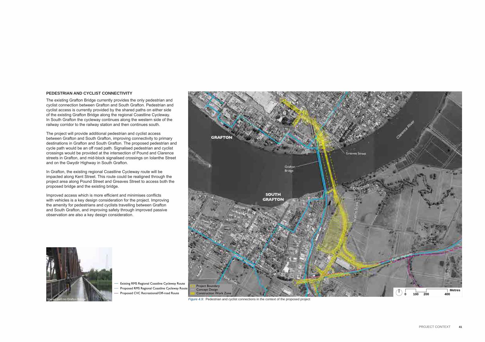
PEDESTRIAN AND CYCLIST CONNECTIVITYThe existing Grafton Bridge currently provides the only pedestrian and cyclist connection between Grafton and South Grafton. Pedestrian and cyclist access is currently provided by the shared paths on either side of the existing Grafton Bridge along the regional Coastline Cycleway. In South Grafton the cycleway continues along the western side of the railway corridor to the railway station and then continues south.
The project will provide additional pedestrian and cyclist access between Grafton and South Grafton, improving connectivity to primary destinations in Grafton and South Grafton. The proposed pedestrian and cycle path would be an off road path. Signalised pedestrian and cyclist crossings would be provided at the intersection of Pound and Clarence streets in Grafton, and mid-block signalised crossings on Iolanthe Street and on the Gwydir Highway in South Grafton.
In Grafton, the existing regional Coastline Cycleway route will be impacted along Kent Street. This route could be realigned through the project area along Pound Street and Greaves Street to access both the proposed bridge and the existing bridge.
Improved access which is more efficient and minimises conflicts with vehicles is a key design consideration for the project. Improving the amenity for pedestrians and cyclists travelling between Grafton and South Grafton, and improving safety through improved passive observation are also a key design consideration.
Shared path on Grafton Bridge
Existing RMS Regional Coastline Cycleway Route
High Archaeological PotentialModerate Archaeological Potential
SILEP_LZNZONE_
B1
B2
B3
B4
B5
B6
B7
B8
DM
E1
E2
E3
E4
IN1
IN2
IN3
IN4
MD
R1
R2
R3
R4
R5
RE1
RE2
RU1
RU2
RU3
RU4
RU5
RU6
SP1
SP2
SP3
UL
W1
W2
W3
Town Centre
Established Residential
Industrial
Rural Hinterland
Major RetailCommercial and RetailEducation
Public park
Riverfront Parkland
Street Tree
Main Street
River ConnectionReedland (EEC)Remnant eucalypt (EEC)Melaleuca plantationNative and exotic plantingNative revegetationPlanted figWeeds and exotic
Degraded riparian forest (EEC)Potential drainage soak (EEC)
Hollow-bearing treeRecorded threatened fauna species
Primary River Recreation Area
NSW Maritime Navigable Channel
Navigable Extend (For 8.5m Tall Boats)
Grafton Waterfront Precinct
Impacted property likely to be fully aquiredImpacted property likely to be partially aquired
Proposed RMS Regional Coastline Cycleway Route
Heritage Item Identified During Project Investigations
Low Archaeological PotentialArchaeological Sites
CVLEP 2011 Heritage Conservation AreaCVLEP 2011 Heritage Listed Items CVLEP 2011 Heritage Listed Significant Tree
State Register Heritage Listed Items
National Trust Listed Items
Proposed CVC Recreational/Off-road Route
Major Local Route
National HIghway
State Route
Heavy Vehicle Diversion Route
Local Road
Arrival Point
Project BoundaryConcept DesignConstruction Work Zone
Figure 4.9: Pedestrian and cyclist connections in the context of the proposed project
Gwydir Highway
Bent
Str
eet
Skin
ner
Stre
et
Villie
rs S
treet
GraftonBridge
SOUTHGRAFTON
GRAFTON
Kent
Stre
et
Breim
ba S
treet
Pacific Highway
Brom
ley S
treet
Clar
ence
Stre
et
Summerland Way
Greaves Street
Pound Street
Bacon Street
Oliver StreetFitzroy StreetVictoria Street
Prin
ce S
treet
Duk
e St
reet
Iola
nthe
Str
eet
Wha
rf St
reet
Through Street
Spring Street
Abb
ott S
tree
t
Cow
an S
tree
t
Vere Street
Metres0 200 400100
Existing RMS Regional Coastline Cycleway Route
High Archaeological PotentialModerate Archaeological Potential
SILEP_LZNZONE_
B1
B2
B3
B4
B5
B6
B7
B8
DM
E1
E2
E3
E4
IN1
IN2
IN3
IN4
MD
R1
R2
R3
R4
R5
RE1
RE2
RU1
RU2
RU3
RU4
RU5
RU6
SP1
SP2
SP3
UL
W1
W2
W3
Town Centre
Established Residential
Industrial
Rural Hinterland
Major RetailCommercial and RetailEducation
Public park
Riverfront Parkland
Street Tree
Main Street
River ConnectionReedland (EEC)Remnant eucalypt (EEC)Melaleuca plantationNative and exotic plantingNative revegetationPlanted figWeeds and exotic
Degraded riparian forest (EEC)Potential drainage soak (EEC)
Hollow-bearing treeRecorded threatened fauna species
Primary River Recreation Area
NSW Maritime Navigable Channel
Navigable Extend (For 8.5m Tall Boats)
Grafton Waterfront Precinct
Impacted property likely to be fully aquiredImpacted property likely to be partially aquired
Proposed RMS Regional Coastline Cycleway Route
Heritage Item Identified During Project Investigations
Low Archaeological PotentialArchaeological Sites
CVLEP 2011 Heritage Conservation AreaCVLEP 2011 Heritage Listed Items CVLEP 2011 Heritage Listed Significant Tree
State Register Heritage Listed Items
National Trust Listed Items
Proposed CVC Recreational/Off-road Route
Major Local Route
National HIghway
State Route
Heavy Vehicle Diversion Route
Local Road
Arrival Point
Project BoundaryConcept DesignConstruction Work Zone
Claren
ce R
iver
Alipou Creek

42 ADDITIONAL CROSSING OF THE CLARENCE RIVER AT GRAFTON | URBAN DESIGN AND LANDSCAPE CONCEPT REPORT (INCLUDING LANDSCAPE CHARACTER AND VISUAL IMPACT ASSESSMENT)
PROPERTY AND BUILT FORMThe proposed bridge and approach roads would have a substantial impact on properties in Grafton, and some impacts on properties in South Grafton. Around 30 properties may require full acquisition and another 20 may require partial acquisition. Of the properties that would be fully acquired, it is anticipated that around 20 dwellings in Grafton would be demolished. Few structures would be impacted in South Grafton; however the proposed changes to the road network would alter access to existing buildings and businesses. The transformation and redefinition of uses for these effected areas will need to carefully consider and reflect the surrounding urban character and form.
Existing RMS Regional Coastline Cycleway Route
High Archaeological PotentialModerate Archaeological Potential
SILEP_LZNZONE_
B1
B2
B3
B4
B5
B6
B7
B8
DM
E1
E2
E3
E4
IN1
IN2
IN3
IN4
MD
R1
R2
R3
R4
R5
RE1
RE2
RU1
RU2
RU3
RU4
RU5
RU6
SP1
SP2
SP3
UL
W1
W2
W3
Town Centre
Established Residential
Industrial
Rural Hinterland
Major RetailCommercial and RetailEducation
Public park
Riverfront Parkland
Street Tree
Main Street
River ConnectionReedland (EEC)Remnant eucalypt (EEC)Melaleuca plantationNative and exotic plantingNative revegetationPlanted figWeeds and exotic
Degraded riparian forest (EEC)Potential drainage soak (EEC)
Hollow-bearing treeRecorded threatened fauna species
Primary River Recreation Area
NSW Maritime Navigable Channel
Navigable Extend (For 8.5m Tall Boats)
Grafton Waterfront Precinct
Impacted property likely to be fully aquiredImpacted property likely to be partially aquired
Proposed RMS Regional Coastline Cycleway Route
Heritage Item Identified During Project Investigations
Low Archaeological PotentialArchaeological Sites
CVLEP 2011 Heritage Conservation AreaCVLEP 2011 Heritage Listed Items CVLEP 2011 Heritage Listed Significant Tree
State Register Heritage Listed Items
National Trust Listed Items
Proposed CVC Recreational/Off-road Route
Major Local Route
National HIghway
State Route
Heavy Vehicle Diversion Route
Local Road
Arrival Point
Project BoundaryConcept DesignConstruction Work Zone
Figure 4.10: Property and built form in the context of the proposed project
Gwydir Highway
Bent
Str
eet
Skin
ner
Stre
et
Villie
rs S
treet
GraftonBridge
SOUTHGRAFTON
GRAFTON
Kent
Stre
et
Breim
ba S
treet
Pacific Highway
Brom
ley S
treet
Clar
ence
Stre
et
Summerland Way
Greaves Street
Pound Street
Bacon Street
Oliver StreetFitzroy StreetVictoria Street
Prin
ce S
treet
Duk
e St
reet
Iola
nthe
Str
eet
Wha
rf St
reet
Through Street
Spring Street
Abb
ott S
tree
t
Cow
an S
tree
t
Vere Street
Metres0 200 400100
Existing RMS Regional Coastline Cycleway Route
High Archaeological PotentialModerate Archaeological Potential
SILEP_LZNZONE_
B1
B2
B3
B4
B5
B6
B7
B8
DM
E1
E2
E3
E4
IN1
IN2
IN3
IN4
MD
R1
R2
R3
R4
R5
RE1
RE2
RU1
RU2
RU3
RU4
RU5
RU6
SP1
SP2
SP3
UL
W1
W2
W3
Town Centre
Established Residential
Industrial
Rural Hinterland
Major RetailCommercial and RetailEducation
Public park
Riverfront Parkland
Street Tree
Main Street
River ConnectionReedland (EEC)Remnant eucalypt (EEC)Melaleuca plantationNative and exotic plantingNative revegetationPlanted figWeeds and exotic
Degraded riparian forest (EEC)Potential drainage soak (EEC)
Hollow-bearing treeRecorded threatened fauna species
Primary River Recreation Area
NSW Maritime Navigable Channel
Navigable Extend (For 8.5m Tall Boats)
Grafton Waterfront Precinct
Impacted property likely to be fully aquiredImpacted property likely to be partially aquired
Proposed RMS Regional Coastline Cycleway Route
Heritage Item Identified During Project Investigations
Low Archaeological PotentialArchaeological Sites
CVLEP 2011 Heritage Conservation AreaCVLEP 2011 Heritage Listed Items CVLEP 2011 Heritage Listed Significant Tree
State Register Heritage Listed Items
National Trust Listed Items
Proposed CVC Recreational/Off-road Route
Major Local Route
National HIghway
State Route
Heavy Vehicle Diversion Route
Local Road
Arrival Point
Project BoundaryConcept DesignConstruction Work Zone
Claren
ce R
iver
Alipou Creek

43Objectives and PrinciPles
5 Objectives and PrinciPles
Urban design and landscape objectives and principles have been prepared for this project to guide the concept design to ensure that the project is physically, visually and operationally integrated with the surrounding environment.
these objectives and principles take into account the desired future landscape and urban design character for the area as set out in the director-General’s environmental assessment requirements and clarence valley council documents, including the clarence river Way Masterplan, Urban tree Management strategy, Grafton city Open space Plan and the Grafton Waterfront Precinct Masterplan. they also reference the key urban design aspects of roads and Maritime beyond the Pavement urban design policy and associated guidelines.
a key consideration in the development of these objectives and principles is to respect the heritage and cultural values of the existing bridge. Furthermore, the objectives and principles are also based on an understanding of the existing landscape and urban values of the area and the landscape and urban design issues that affect, or are affected by the project.
these wider values include the understanding that the project should integrate with the immediate and surrounding context, enhancing Grafton as a attractive town with wide, tree lined streets. the neighbourhood areas should be kept liveable, walkable, cycle-able, well scaled, visually attractive and safe. the natural systems and ecological biodiversity should be protected, as far as possible, and used to contribute to unique character of the place, recreational uses, outdoor lifestyle values of the area and the overall sustainability of the project. additionally, the extent and quality of all public open space should be reinforced, particularly along the clarence river foreshore areas.
as a broad approach to the design and construction of the bridge, its approach roads and the ancillary works, the principles of ecologically sustainable development should underpin all decisions. amongst other factors, this would ensure that the most economical use of resources
is achieved during both the construction and operation of the project. For example, project elements would be designed using robust, low maintenance materials that would also minimise the potential for vandalism.
the following eight urban design objectives are based on the contextual analysis of the site and the proposed project, and are accompanied by a series of principles which provide a high level urban design response to each of the objectives.
the urban design objectives related to the following:
• landscape and scenic Quality,• Urban Form,• Heritage and cultural values• relationship of the Proposed bridge to the existing Historic bridge• design of the approach roads• User connectivity• Urban development• Public domain.

44 ADDITIONAL CROSSING OF THE CLARENCE RIVER AT GRAFTON | URBAN DESIGN AND LANDSCAPE CONCEPT REPORT (INCLUDING LANDSCAPE CHARACTER AND VISUAL IMPACT ASSESSMENT)
LANDSCAPE AND SCENIC QUALITY Objective: To achieve a project that fits sensitively with the existing qualities and characteristics of Grafton, South Grafton and its Clarence River setting.
design principles:
• Protect and integrate the river environment including foreshore areas, into the overall project design.
• Maintain important recognisable views of the river, foreshore areas and townscape, in particularly those views to and from the existing bridge
• Design the project to fit in naturally with the local topography and river setting.
• design major project elements like earthworks, embankments, and mounding to fit into its setting and reduce its visual and physical obtrusiveness.
• integrate natural patterns and ecology into the design of the project, protect creeks, retain physical continuity of natural systems, and use natural characteristics in the project’s landscape design.
• Minimise the intrusion of project related elements on the local landscape, such as lighting, barriers, fencing and flood control elements.
HERITAGE AND CULTURAL VALUESObjective: To protect the integrity of the heritage and cultural values of the Grafton area.
design principles:
• Minimise the impact of the project on state and locally listed aboriginal and non-aboriginal sites, buildings and precincts and their contribution to the setting and character of the area.
• respect and incorporate places and sites of aboriginal value in the overall project design.
• Minimise impacts to heritage listed tree species and cultural plantings.
• retain the cultural qualities and identity of Grafton through sensitive design.
URBAN FORM Objective: To maintain the integrity of the existing urban character, particularly the physical and visual experience of the streetscape and street grid.
design principles:
• Protect the built fabric and streetscape quality of the existing neighbourhoods by integrating the project into the existing character of Grafton and south Grafton.
• retain the existing urban character of the neighbourhood areas, for example by minimising the removal of street trees that provide a sense of place.
• Minimise the effects of fragmentation on neighbourhoods and precinct areas.
• Minimise the effects on the general form of the existing grid and urban settlement patterns.
45Objectives and PrinciPles
USER CONNECTIVITYObjective: To contribute to the accessibility and connectivity into and through Grafton and surrounding areas.
design principles:
• retain permeability of movement through areas by maintaining the continuity of the street grid and laneway systems.
• improve connectivity around and through the project area for all modes of transport and user groups.
• Maximise safe pedestrian and bicycle crossings on streets and at intersections that are attractive, easy to use and minimise crossing distances.
• integrate the pedestrian and cycle path of the proposed bridge as a continuous system with the clarence valley council’s existing and future planned network in Grafton and south Grafton.
• improve connectivity to existing and potential future riverfront public recreation spaces.
• Provide attractive, safe and accessible undercroft areas adjacent to the abutments for potential future foreshore and local pedestrian and cycle access.
DESIGN OF THE APPROACH ROADSObjective: To achieve an integrated road design form and character that blends with the adjoining areas.
design principles:
• design the approach roads to not visually dominate the landscape.• Minimise the potential visual and physical barrier effect of the
approach roads by maintaining cross connections for local traffic, public transport, cyclists and pedestrians.
• Minimising the footprint and scale of the approach roads and intersections.
• Minimise the size of intersections between the approach roads and the existing local roads.
• integrate and coordinate the approach road elements with adjoining road elements and structures.
• Minimise the height and extent of noise walls, retaining walls and embankments along the approach roads.
• Maximise the opportunities to rehabilitate the streetscapes impacted by the proposed approach roads.
RELATIONSHIP OF THE PROPOSED BRIDGE TO THE EXISTING HISTORIC BRIDGEObjective: To protect the integrity of the existing State Heritage-listed Bridge as the pre-eminent structure in its setting.
design principles:
• design the proposed bridge to minimise the loss of views towards to the existing bridge.
• create a new landmark crossing over the river at Grafton through a complementary relationship of the proposed bridge with the old bridge having regard to form, scale and function.
• design the proposed bridge to have a contemporary form and scale that complements the existing bridge and allows it to take visual precedence:
• Design all of the proposed bridge elements as part of unified bridge architecture, minimising the bulk and massing of the bridge elements.
• Design the soffit of the proposed bridge to create a visually attractive form, particularly in areas that will be highly visible to the public.
• design the shared path on the bridge to maximise the visual experience for pedestrians and cyclists, and consider a sequence of events such as stopping points to improve users experience.
• design all lighting and signage on the proposed bridge to be unobtrusive against the existing bridge and in the landscape.
• Minimise over-shadowing and over-looking from the proposed bridge structure and viaducts on adjoining residential areas.
46 ADDITIONAL CROSSING OF THE CLARENCE RIVER AT GRAFTON | URBAN DESIGN AND LANDSCAPE CONCEPT REPORT (INCLUDING LANDSCAPE CHARACTER AND VISUAL IMPACT ASSESSMENT)
PUblic dOMain
Objective: to enhance the quality and value of the public domain along and surrounding the project area.
design principles:
• Minimise negative physical impacts on public, open space, the river and other foreshore areas adjacent to the bridge and on the existing activities.
• design the project to accommodate potential new uses and improvements in existing and new public domain spaces along the river foreshore.
• design the project to ensure that the spaces under and around the bridge and viaducts are appropriately integrated into the public domain.
• design the project to create town entry treatments that are attractive and inviting.
• design the project to ensure good surveillance for pedestrians and cyclists on and around the bridge and its approach roads.
Urban develOPMent
Objective: to create a project that facilitates future urban development and revitalisation along and surrounding the project area.
design principles:
• design the proposed bridge and associated infrastructure so that it can support future development and revitalisation of surrounding retail, commercial, industrial, recreational and educational areas.
• Work with council to facilitate the consolidation of residual land parcels into sufficiently useable areas that can be redeveloped appropriately, consistent with surrounding land uses.
• consider the potential for new uses of residual and underutilised areas impacted by the project.
• Provide suitable streetscape design that will facilitate new public and private related land uses.

47Urban Design, briDge anD LanDscape concept
6 Urban Design, briDge anD LanDscape concept

48 ADDITIONAL CROSSING OF THE CLARENCE RIVER AT GRAFTON | URBAN DESIGN AND LANDSCAPE CONCEPT REPORT (INCLUDING LANDSCAPE CHARACTER AND VISUAL IMPACT ASSESSMENT)
6.1 oVerVieW
Figure 6.1: LanDscape anD Urban Design concept – oVerVieWrefer to Landscape and Urban Design concept plans for more detail.
the urban design, bridge and landscape concept has been developed based on the objectives and principles described in chapter 5, to achieve an integrated concept design for the project. this chapter describes the interrelationship between the proposed bridge and road works and the adjoining areas in the form of an indicative urban design and landscape concept plan. the concept design presented here includes the bridges, retaining walls, noise barriers, cuttings and fill embankments. The structures shown on the drawings in this chapter reflect the current engineering concept design for the structural elements; for a detailed discussion and drawings of the structures, refer to the corresponding sections of the eis. the landscape concept includes planting to integrate the proposed works with the existing character of the local area, as well as feature planting to define the township entries and other cultural areas.
the urban design, bridge and landscape concept identifies a series of recommended works that should occur in conjunction with the construction of the bridge and its associated roadworks, within the defined project area. This concept provides the basis for determination of the environmental assessment process, as well as future detailed design and construction documentation.
Further mitigation measures are identified in Chapter 8 of this report, which describes opportunities to better integrate the project into the grafton area. the detailed design and documentation of these works, both inside and outside the project area would be the subject of comprehensive consultation with a range of stakeholders including state government agencies, clarence Valley council and the grafton community.

49Urban Design, briDge anD LanDscape concept

50 ADDITIONAL CROSSING OF THE CLARENCE RIVER AT GRAFTON | URBAN DESIGN AND LANDSCAPE CONCEPT REPORT (INCLUDING LANDSCAPE CHARACTER AND VISUAL IMPACT ASSESSMENT)
this page has been left intentionally blank.

Plate 6.1: View along existing pound street, looking north west
Plate 6.2: View along existing clarence street, looking south west
Plate 6.3: View along existing pound street, looking south east
51Urban Design, briDge anD LanDscape concept
the following describes the key urban design and landscape components of the concept Design as observed travelling towards the river. the Urban Design and Landscape concept plan and sections for grafton are presented on the following pages.
ROADWORKSPound StreetFrom the north, the proposed works would commence at the intersection with Villiers street. pound street would be widened to accommodate two lanes of traffic in both directions, with wide shoulders replaced with kerb and gutter. sealed angle parking on the northern side and parallel parking on the southern side would be introduced.
Formal garden beds are proposed at the intersections of pound street with Villiers street and clarence street. these would be planted with attractive shrubs and groundcovers to provide a visual entry to this section of pound street. smaller street trees would be planted along the northern side of the street, within the angle parking zone and where space permits, to provide shade and to reduce the visual scale of the street due to the removal of a number of existing mature trees. on the southern side, Fig trees would be planted within the grafton taFe where it has been affected by the works (subject to agreement with the taFe). street trees (Jacaranda) would also be planted on pound street, east of clarence street, signifying the entry to grafton town centre.
it is proposed to use a visually contrasting pavement material such as permeable pavers, in the designated parking areas to visually break up the large expanse of asphalt with a different texture and tone, and to potentially assist in reducing stormwater runoff. this would be subject to acceptance from clarence Valley council.
a 2.5 metre wide pedestrian and cycle path would be provided on the southern side of pound street, improving local connectivity by linking grafton and south grafton via the new bridge. a 1.5 metre wide pedestrian path would be provided between Villiers street and clarence street on the northern side to replace the existing path.
east of clarence street, seven existing houses would be demolished. on the northern side, these would be replaced by an off street car park with about 26 car park spaces. trees would be planted to the carpark boundary to provide shade and to screen the carpark. on the southern side, the land would be turfed and scattered native trees planted to create a park-like character.
Clarence Streetclarence street, south of pound street, would be widened to accommodate two northbound lanes and one southbound lane. the open grassed swales to the existing verges would be replaced with kerb and gutter and paved shoulders for angle and parallel parking, with 90º parking in the centre of the road.
small street trees would be planted on the western side of the street only, due to space constraints. a 1.2 metre wide pedestrian path would be located on the western side, linking pound street with the taFe driveway entrance. the verge on the eastern side would be turfed to be consistent with the existing character. The traffic islands at either end of the 90º parking would be planted with exotic shrub and groundcover planting.
Northern bridge approach roadas pound street approaches the bridge, it becomes a two lane road with a narrow raised median, on an elevated fill embankment. A retaining wall about 1.3 metre high and 51 metre long would be constructed on the eastern side of the approach road. on top of the wall, and extending 310 metres to the river, would be a transparent noise barrier, enabling views of the surrounding landscape and river for motorists.
On the eastern side, the fill embankment would be planted with native shrubs and groundcovers, softening the base of the road infrastructure. trees would be planted in small stands, providing some screening of the road works while still allowing views of the landscape for motorists. Up to 15 houses would be demolished in the area bounded by pound street, greaves street and the proposed approach road. this area would be grassed, with appropriate existing trees retained where possible, and supplemented with new native tree planting to provide a parkland character.
on the western side, a fenced water detention basin would be constructed. it would be planted with native grasses to better integrate it into the landscape. the embankment south of this would be planted with native grasses.
a new 2.5 metre wide pedestrian and cycle path would be provided on the western side, next to the approach road. it is proposed to edge the path with a 1.4 metre high galvanised fence for user safety where it occurs on the raised embankment. the new path would link with the existing pedestrian path that crosses the existing bridge.
6.2 graFton

Plate 6.4: existing railway viaduct over pound street, grafton
Plate 6.5: existing railway bridge over the gwydir Highway, south grafton
Plate 6.6: example of blockwork retaining wall Plate 6.7: example of transparent noise wall
52 ADDITIONAL CROSSING OF THE CLARENCE RIVER AT GRAFTON | URBAN DESIGN AND LANDSCAPE CONCEPT REPORT (INCLUDING LANDSCAPE CHARACTER AND VISUAL IMPACT ASSESSMENT)
Greaves Streetgreaves street would be slightly lowered at bridge abutment b to provide the necessary height clearance to the bridge above. it is proposed to turf the required small cutting and area under the bridge to provide stabilisation and easy access to the underside of the bridge for maintenance.
the area between greaves street and the river foreshore, where construction activities are proposed, would be grassed and planted with native trees to retain the existing character of the river foreshore.
Dobie Street and Villiers Street intersectionMinor kerb modifications are proposed to the intersection of Dobie Street and Villiers street. any planting removed during construction would be replaced by similar species.
RAILWAY BRIDGEthe low clearance on the existing railway bridge over pound street (refer plate 6.4) would prevent trucks travelling across the proposed grafton bridge from entering grafton or continuing along the summerland Way. the creation of adequate clearance under the existing bridge would require the lowering of pound street, which in turn would increase flooding risks in an already flood prone area. In order to provide adequate clearance over and avoid additional flood impacts, it is proposed that a new railway bridge replace the existing pound street bridge.
the proposed new bridge would be a single span steel truss bridge connecting the existing railway viaduct to the existing railway embankment on the northern side of pound street. the use of a steel truss provides the required clearance over pound street without needing to lower the street level. it also references the steel truss railway bridge over the gwydir Highway in south grafton (refer plate 6.5), as well as the iconic steel truss of the existing grafton bridge.
additionally, the widening of pound street would affect the adjacent piers and abutment of the existing railway viaduct. the existing abutment would require strengthening, and the final viaduct pier (on the southern side of pound street) would require either strengthening or replacement (subject to further structural design investigations).
Urban design recommendations• the steel truss should be painted using a micaceous iron oxide paint
in a dark grey colour, in keeping with the steelwork on the railway bridge over the gwydir Highway.
• if a new pier is required on the southern side of pound street, it should be a simple concrete blade pier with detailing to match the piers of the existing railway viaduct.
• The abutment modifications on the northern side of Pound Street should be off form concrete with simple clean detailing, in keeping with the character of the existing abutment and the abutments of the other railway bridges in grafton.
Rationale• to tie in the new railway bridge works with the character of the
existing viaduct at pound street• to create a recognisable ‘family’ of steel truss bridges in the grafton
area. the new pound street railway bridge and the existing railway bridge over the gwydir Highway would form distinctive landmarks at the arrival to grafton and south grafton along the summerland Way.
STORMWATER MANAGEMENT SYSTEMa stormwater management system is required at pound street to provide flood-free access to the proposed bridge in a 20 year average recurrence interval flood event. The stormwater management system would include:
• a detention basin north of greaves street, between the approach road and the railway line.
• culverts beneath the approach road in the vicinity of bridge street to connect the catchment north of pound street to the detention basin.
• A flood pumping station south of Greaves Street to extract water from the detention basin and convey it to the clarence river. the pumping station would be predominantly below ground, except for the switchboard and backup generator, which would be mounted on a concrete slab near the crest of the existing levee. the slab would be at RL 8.25m to avoid the 1:100 year flood event, while the switchboard and generator would be located within enclosures up to 2.4 metres high.
• Culverts between the flood pumping station and the Clarence River
(source: Bridge Aesthetics, roads and Maritime, 2012)

53Urban Design, briDge anD LanDscape concept
Urban design recommendations• Minimise the size of the proposed permanent basin. • plant with native grasses.• investigate opportunities to reduce batter steepness to avoid the need
for fencing around the detention basin.
Rationale• to provide a natural aesthetic.
RETAINING WALLa retaining wall would be required on the eastern side of the approach road, opposite the reconfigured intersection of Pound Street and Bridge street. the retaining wall would be about 51 metres long and up to 1.3 metres high. a 820mm high concrete vehicle barrier would be required at the top of the retaining wall, making the overall height of the wall a maximum of 2.12 metres.
Urban design recommendations • Utilise materials appropriate to the residential context of grafton, for
example, a combination of split-faced and smooth-faced blockwork in a light colour (refer to plate 6.6).
• Applied finishes (such as painting) are to be avoided.
Rationale • A site specific design response allows the wall to individually respond
to the local landscape character. • Light coloured blockwork contrasts with the character of the industrial
grey concrete of the nearby road and rail viaducts.• Applied finishes require additional long term ongoing maintenance.
NOISE BARRIERacoustic assessment of the concept design indicates that a noise barrier would be required to mitigate noise impacts from the elevated bridge and approach road on the surrounding neighbourhood. the noise barrier would be:
• 3.0 metres high, measured from the road surface.• approximately 310 metres long, located between the grafton
waterfront and bridge street.
Urban design recommendations• transparent panels. angle panels away from the carriageway to
enhance natural cleaning (refer to plate 6.7). • align the noise barrier posts with the posts for the twin rail barrier.
Rationale• transparent panels allow views of the existing landscape and river. • transparent panels aid in the visual reduction of the road
infrastructure and bridge. • Aligning barriers posts creates a unified and coordinated appearance
to the roadside elements.

54 ADDITIONAL CROSSING OF THE CLARENCE RIVER AT GRAFTON | URBAN DESIGN AND LANDSCAPE CONCEPT REPORT (INCLUDING LANDSCAPE CHARACTER AND VISUAL IMPACT ASSESSMENT)

55Urban Design, briDge anD LanDscape concept
Figure 6.2: Urban Design anD LanDscape concept pLan – sHeets 1 & 2Scale 1:1000

56 ADDITIONAL CROSSING OF THE CLARENCE RIVER AT GRAFTON | URBAN DESIGN AND LANDSCAPE CONCEPT REPORT (INCLUDING LANDSCAPE CHARACTER AND VISUAL IMPACT ASSESSMENT)
Figure 6.3: section aa at cH 1900Scale 1:250
Figure 6.4: section bb cLarence streetScale 1:250

57Urban Design, briDge anD LanDscape concept
Figure 6.5: section cc at cH 1700Scale 1:250
Figure 6.6: section DD at cH 1620Scale 1:250

58 ADDITIONAL CROSSING OF THE CLARENCE RIVER AT GRAFTON | URBAN DESIGN AND LANDSCAPE CONCEPT REPORT (INCLUDING LANDSCAPE CHARACTER AND VISUAL IMPACT ASSESSMENT)
Figure 6.7: section ee at cH 1540Scale 1:250
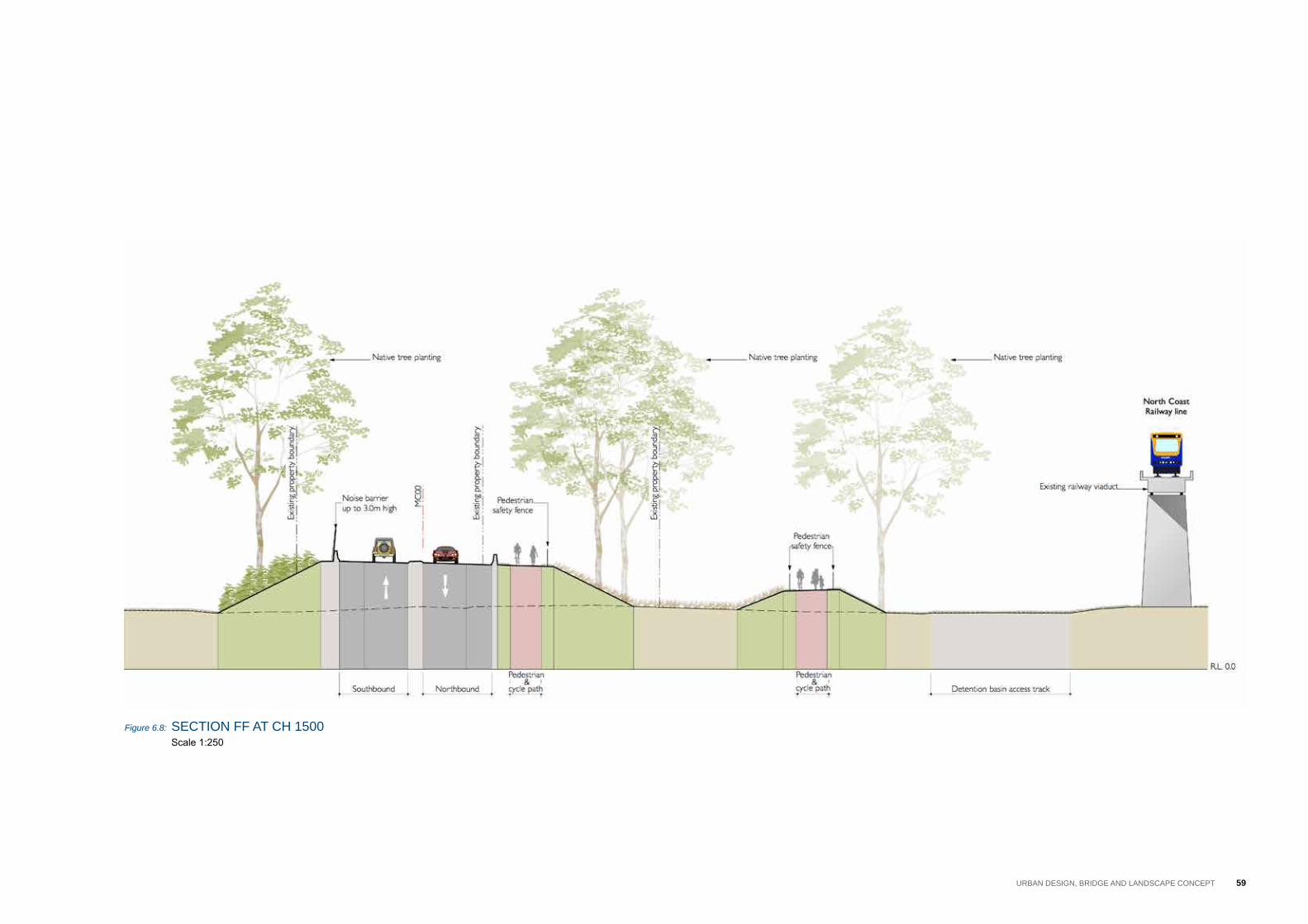
Figure 6.8: section FF at cH 1500Scale 1:250
59Urban Design, briDge anD LanDscape concept

60 ADDITIONAL CROSSING OF THE CLARENCE RIVER AT GRAFTON | URBAN DESIGN AND LANDSCAPE CONCEPT REPORT (INCLUDING LANDSCAPE CHARACTER AND VISUAL IMPACT ASSESSMENT)
Figure 6.9: section gg at cH 1400Scale 1:250

GRAFTON BRIDGE DUPLICATIONBRIDGE OPTIONS – VISUALISATIONS • PREPARED BY SPACKMAN MOSSOP MICHAELS FOR ARUP & RMS •
VIEW FROM RIVER - UPSTREAMOPTION 1B
0.5% longitudinal gradeHaunched box girder
DRAFT9 Jan 2014
Figure 6.10: View of proposed grafton bridge from the clarence river
61Urban Design, briDge anD LanDscape concept
6.3 tHe proposeD graFton briDge
OVERVIEWthe concept design for the proposed grafton bridge has developed through an iterative process where the project team members from all relevant disciplines have worked collaboratively to achieve an integrated outcome for the bridge. the urban design concept for the bridge has been developed in accordance with the roads and Maritime bridge aesthetics guide (2012), and in response to the requirements for bridge and structure design, road design, drainage design and lighting design. the following section describes the design outcomes of this process.
the proposed bridge would be a 553 metre long concrete bridge located approximately 70 metres downstream of the existing grafton bridge. The bridge would accommodate one lane of traffic in each direction. A pedestrian and cycle path would be located on the upstream side of the bridge, facing the existing bridge, to connect with the existing local network.
SITING RELATIONSHIP TO THE EXISTING BRIDGEthe horizontal position of the proposed bridge over the clarence river is governed by the need to tie in with the alignment of pound street in grafton and to minimise impacts on alipou creek and the existing sugar loading facility in south grafton. Within these constraints, the proposed bridge has been designed to be as parallel as possible to the existing bridge.
The proposed bridge has 10 spans, with five piers in the Clarence River and two piers on land at each foreshore. the piers have been positioned
to align as closely as possible with the piers of the existing bridge, especially those in the river itself.
the proposed bridge structure has been kept as low as possible over the clarence river in order to allow the existing bridge to take visual precedence and to minimise the loss of views to the existing bridge. However, the height of the bridge also responds to other key factors, namely:
• the bridge must allow for two 9.1 metre high navigation channels at Mean High Water spring (MHWs).
• the depth of the superstructure is governed by the span lengths between the piers, the positions of which have been determined by the positions of the piers on the existing bridge.
Within these parameters, the road level at the centre of the proposed bridge would be approximately 15.4 metres above the river at MHWs – roughly halfway between the levels of the road deck and the railway deck on the existing grafton bridge.
OVERALL FORMThe proposed bridge has a straight horizontal alignment that simplifies construction while also referencing the straight alignment of the existing bridge. the vertical alignment would be a continuous curve with a crest in the centre of the bridge to facilitate bridge drainage. the longitudinal grades have been kept as ‘flat’ as possible to complement the flat alignment of the existing bridge while also meeting the necessary drainage requirements.
BRIDGE GIRDERSthe proposed bridge superstructure would be concrete, which allows for a simple, clean, contemporary character that allows the steel truss of the existing bridge to take visual precedence. the superstructure would have two types of girders:
• spans 3 to 9 have a single haunched box girder that responds to the long spans over the Clarence River. The girder would be about five metres deep at the piers and about three metres deep at mid-spans.
• spans 1, 2 and 10 have super t girders that are about 1.2 metres deep to minimise the structural depth of the bridge over the existing ground behind the levees in grafton and south grafton.
the bridge spans over the clarence river are about 74 metres long to match the spans on the existing bridge. the length of the spans necessitate an approximately five metre deep girder over the piers, which, combined with the required 1.3 metre high bridge barrier, would result in an overall bridge depth of about 6.3 metres at the piers over the river. in order to reduce the visual ‘bulk’ of the proposed bridge and provide structural efficiency, the girder depth has been minimised at mid-spans to about 3 metres, resulting in a haunched superstructure. the long spans allow for long, smoothly tapering haunches that create a slender and graceful appearance to the proposed bridge when viewed in elevation.
BRIDGE DECKthe concrete bridge deck is approximately 16.9 metres wide and accommodates two vehicle lanes, shoulders, a median, a pedestrian
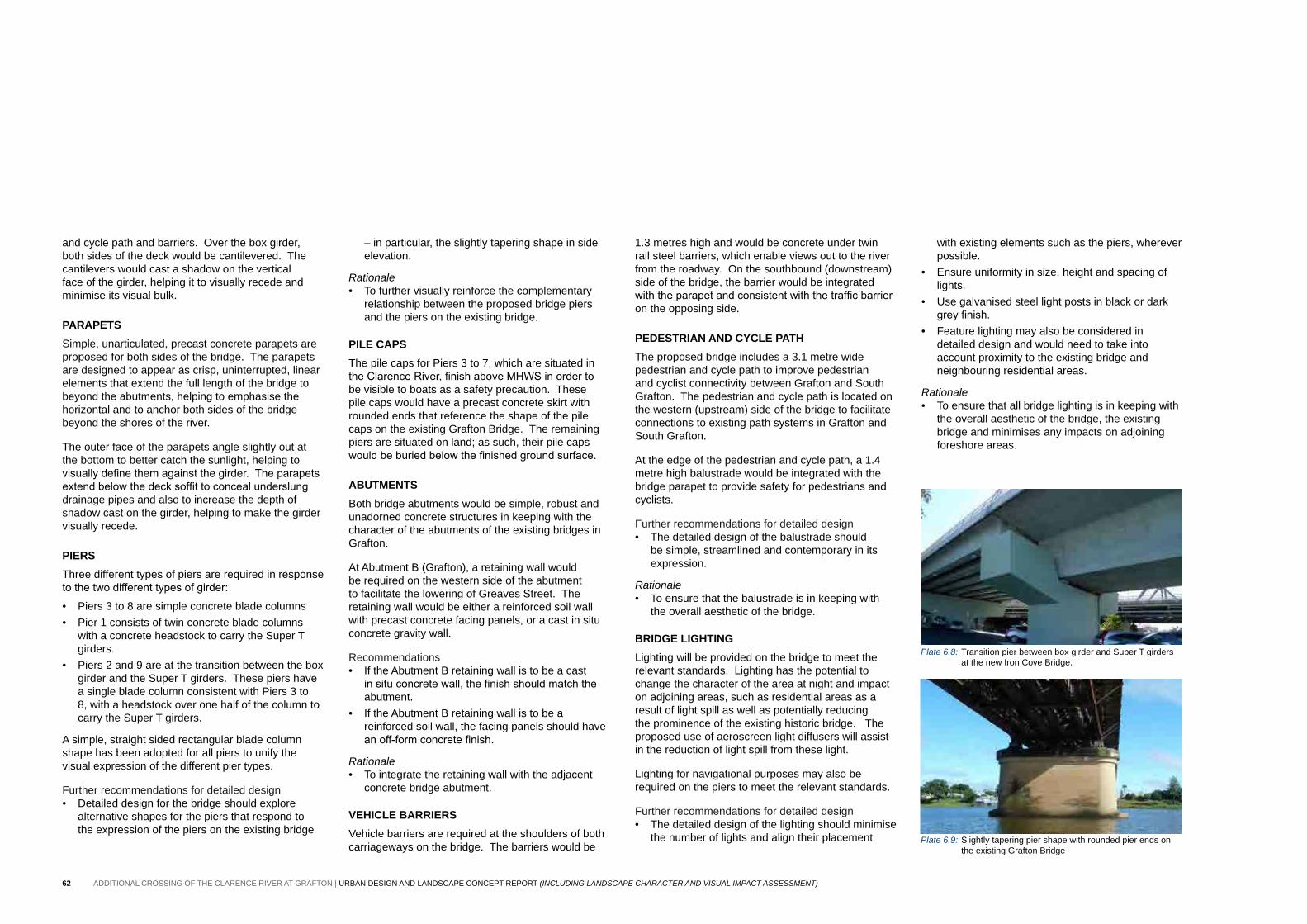
Plate 6.8: transition pier between box girder and super t girders at the new iron cove bridge.
Plate 6.9: slightly tapering pier shape with rounded pier ends on the existing grafton bridge
62 ADDITIONAL CROSSING OF THE CLARENCE RIVER AT GRAFTON | URBAN DESIGN AND LANDSCAPE CONCEPT REPORT (INCLUDING LANDSCAPE CHARACTER AND VISUAL IMPACT ASSESSMENT)
and cycle path and barriers. over the box girder, both sides of the deck would be cantilevered. the cantilevers would cast a shadow on the vertical face of the girder, helping it to visually recede and minimise its visual bulk.
PARAPETS simple, unarticulated, precast concrete parapets are proposed for both sides of the bridge. the parapets are designed to appear as crisp, uninterrupted, linear elements that extend the full length of the bridge to beyond the abutments, helping to emphasise the horizontal and to anchor both sides of the bridge beyond the shores of the river.
the outer face of the parapets angle slightly out at the bottom to better catch the sunlight, helping to visually define them against the girder. The parapets extend below the deck soffit to conceal underslung drainage pipes and also to increase the depth of shadow cast on the girder, helping to make the girder visually recede.
PIERSthree different types of piers are required in response to the two different types of girder:
• piers 3 to 8 are simple concrete blade columns • pier 1 consists of twin concrete blade columns
with a concrete headstock to carry the super t girders.
• piers 2 and 9 are at the transition between the box girder and the super t girders. these piers have a single blade column consistent with piers 3 to 8, with a headstock over one half of the column to carry the super t girders.
a simple, straight sided rectangular blade column shape has been adopted for all piers to unify the visual expression of the different pier types.
Further recommendations for detailed design• Detailed design for the bridge should explore
alternative shapes for the piers that respond to the expression of the piers on the existing bridge
– in particular, the slightly tapering shape in side elevation.
Rationale• to further visually reinforce the complementary
relationship between the proposed bridge piers and the piers on the existing bridge.
PILE CAPSthe pile caps for piers 3 to 7, which are situated in the Clarence River, finish above MHWS in order to be visible to boats as a safety precaution. these pile caps would have a precast concrete skirt with rounded ends that reference the shape of the pile caps on the existing grafton bridge. the remaining piers are situated on land; as such, their pile caps would be buried below the finished ground surface.
ABUTMENTSboth bridge abutments would be simple, robust and unadorned concrete structures in keeping with the character of the abutments of the existing bridges in grafton.
at abutment b (grafton), a retaining wall would be required on the western side of the abutment to facilitate the lowering of greaves street. the retaining wall would be either a reinforced soil wall with precast concrete facing panels, or a cast in situ concrete gravity wall.
recommendations• if the abutment b retaining wall is to be a cast
in situ concrete wall, the finish should match the abutment.
• if the abutment b retaining wall is to be a reinforced soil wall, the facing panels should have an off-form concrete finish.
Rationale• to integrate the retaining wall with the adjacent
concrete bridge abutment.
VEHICLE BARRIERSVehicle barriers are required at the shoulders of both carriageways on the bridge. the barriers would be
1.3 metres high and would be concrete under twin rail steel barriers, which enable views out to the river from the roadway. on the southbound (downstream) side of the bridge, the barrier would be integrated with the parapet and consistent with the traffic barrier on the opposing side.
PEDESTRIAN AND CYCLE PATHthe proposed bridge includes a 3.1 metre wide pedestrian and cycle path to improve pedestrian and cyclist connectivity between grafton and south grafton. the pedestrian and cycle path is located on the western (upstream) side of the bridge to facilitate connections to existing path systems in grafton and south grafton.
at the edge of the pedestrian and cycle path, a 1.4 metre high balustrade would be integrated with the bridge parapet to provide safety for pedestrians and cyclists.
Further recommendations for detailed design• the detailed design of the balustrade should
be simple, streamlined and contemporary in its expression.
Rationale• to ensure that the balustrade is in keeping with
the overall aesthetic of the bridge.
BRIDGE LIGHTINGLighting will be provided on the bridge to meet the relevant standards. Lighting has the potential to change the character of the area at night and impact on adjoining areas, such as residential areas as a result of light spill as well as potentially reducing the prominence of the existing historic bridge. the proposed use of aeroscreen light diffusers will assist in the reduction of light spill from these light.
Lighting for navigational purposes may also be required on the piers to meet the relevant standards.
Further recommendations for detailed design• the detailed design of the lighting should minimise
the number of lights and align their placement
with existing elements such as the piers, wherever possible.
• ensure uniformity in size, height and spacing of lights.
• Use galvanised steel light posts in black or dark grey finish.
• Feature lighting may also be considered in detailed design and would need to take into account proximity to the existing bridge and neighbouring residential areas.
Rationale• to ensure that all bridge lighting is in keeping with
the overall aesthetic of the bridge, the existing bridge and minimises any impacts on adjoining foreshore areas.

63Urban Design, briDge anD LanDscape concept
Figure 6.11: section HH at cH 1160 Scale 1:250

64 ADDITIONAL CROSSING OF THE CLARENCE RIVER AT GRAFTON | URBAN DESIGN AND LANDSCAPE CONCEPT REPORT (INCLUDING LANDSCAPE CHARACTER AND VISUAL IMPACT ASSESSMENT)

65Urban Design, briDge anD LanDscape concept
Figure 6.12: Urban Design anD LanDscape concept pLan – sHeets 3 & 4 Scale 1:1000

66 ADDITIONAL CROSSING OF THE CLARENCE RIVER AT GRAFTON | URBAN DESIGN AND LANDSCAPE CONCEPT REPORT (INCLUDING LANDSCAPE CHARACTER AND VISUAL IMPACT ASSESSMENT)
Figure 6.13: briDge eLeVation Scale 1:1000

67Urban Design, briDge anD LanDscape concept

68 ADDITIONAL CROSSING OF THE CLARENCE RIVER AT GRAFTON | URBAN DESIGN AND LANDSCAPE CONCEPT REPORT (INCLUDING LANDSCAPE CHARACTER AND VISUAL IMPACT ASSESSMENT)
Figure 6.14: briDge cross section b1 Scale 1:100

69Urban Design, briDge anD LanDscape concept
Figure 6.15: briDge cross section b2 Scale 1:100
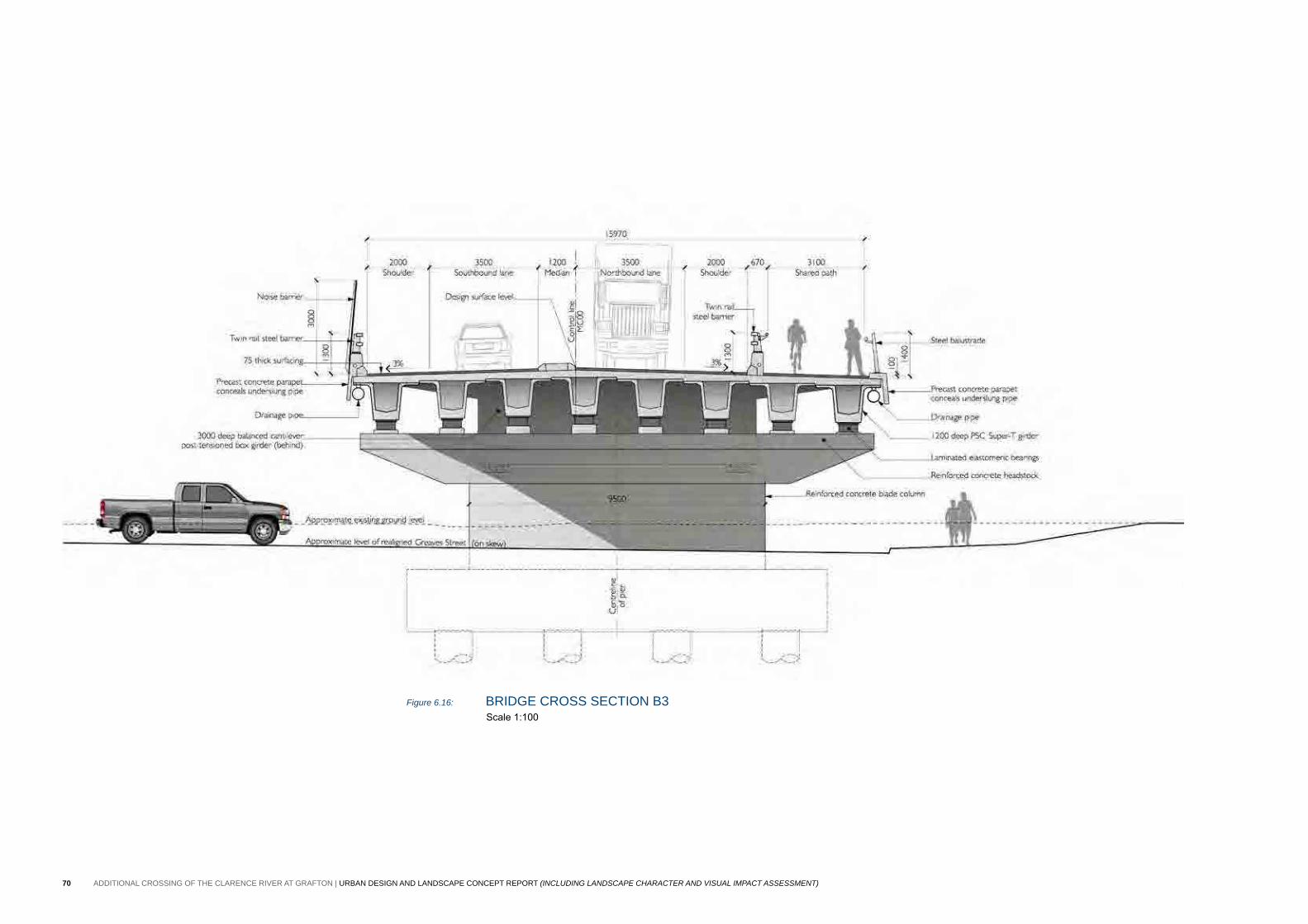
70 ADDITIONAL CROSSING OF THE CLARENCE RIVER AT GRAFTON | URBAN DESIGN AND LANDSCAPE CONCEPT REPORT (INCLUDING LANDSCAPE CHARACTER AND VISUAL IMPACT ASSESSMENT)
Figure 6.16: briDge cross section b3 Scale 1:100
Plate 6.10: View along existing iolanthe street, looking south
Plate 6.11: View along existing gwydir Highway, looking east
71Urban Design, briDge anD LanDscape concept
6.4 soUtH graFton
the following describes the key urban design and landscape components of the concept Design as observed travelling away from the river. the Urban Design and Landscape concept plan and sections for south grafton are presented on the following pages.
ROADWORKSSouthern bridge approach roadtravelling south from the new bridge, the two lane approach road and 2.5 metre wide pedestrian and cycle path would be elevated on a 1 in 2 fill embankment of up to about 7.25 metres high. It is proposed to provide pasture grasses on the embankments to maintain the surrounding rural character. scattered stands of native trees would be planted on the eastern embankment to allow expansive views over the existing grazing land.
on the western embankment, a native tree avenue treatment is proposed, to provide shade for pedestrians and cyclists and a visual identity for the bridge approach road. The flat area between the embankment and the railway line would consist of pasture grasses with occasional stands of native trees to maintain the existing rural character.
the pedestrian and cycle path, on the western side of the road, would be edged by a 1.4 metre high galvanised steel fence. the path would link with the existing coastline cycleway near the foreshore (refer to the Urban Design and Landscape concept plan on page 78).
Pacific Highway connection and former Pacific HighwayThe Pacific Highway (Charles Street) would be realigned north of bunnings Warehouse along iolanthe street, connecting to the new bridge approach road and through street. it would consist of one lane in each direction, with a right turn lane into the realigned butters Lane extension. it is proposed to maintain the existing character of the highway with pasture grasses to the verges and fill embankments. New native trees would supplement existing plantings on the southern side of the highway, with small stands on the northern side allowing views over the grazing land.
the butters Lane connection would consist of a two lane road with avenue tree planting (casuarinas and Melaleucas) to tie in with existing trees. the area between the connection road and the highway connection would be heavily planted with native trees.
The former Pacific Highway, south of Bunnings Warehouse, would consist of two lanes, with a turning area and a left turn only onto the Pacific Highway connection at the eastern end. On the southern side, new native tree planting would supplement existing planting. a 2.5 metre wide pedestrian and cycle path is proposed to link iolanthe street (south), running between the bunnings Warehouse carpark and supercheap auto, crossing the former highway and continuing east on the southern side of the highway (refer to the Urban Design and Landscape concept plan on page 84).
Through Streetthe existing through street would be sealed and consist of a two laned cul-de-sac with single lane access to the gravel track that travels parallel to the railway line. new concrete driveway would be provided from through street to the existing commercial businesses. the verges would be grassed and avenue planted with hardy exotic species. the area between the businesses and through street would be grassed and planted with small stands of native trees.
Iolanthe Streetiolanthe street, between through street and gwydir Highway, would be formalised to contain two lanes in each direction. Traffic signals would be located mid block between through street and spring street. a pedestrian and cycle path would be located on the western side of iolanthe street and would link with the coastline cycleway at Derek palmer place. native street trees would be planted on the eastern side of the street where space permits.
Spring Streetspring street would be upgraded between iolanthe street and the McDonald’s entry, consisting of three lanes, with left and right turn lanes into McDonald’s and the clarence river tourist information centre, and a left turn only onto iolanthe street. a 1.5 metre wide footpath would be provided on the northern side of the street, with hardy exotic street tree planting provided.
Gwydir Highwaygwydir Highway would be realigned and widened and would consist of two lanes in each direction. Traffic signals would be provided at the intersection of the highway and the coastline cycleway. the verges would be grassed and planted with Jacarandas, denoting the major entry
point into South Grafton from the Pacific Highway. New planting would supplement existing plants around the ‘grafton - a tidy town sign.
Roundaboutstwo new roundabouts would be constructed, one at the intersection of through street and iolanthe street/ southern approach road, and one at the intersection of gwydir Highway, iolanthe street (south) and Pacific Highway. They signify the major entries into Grafton via the new bridge, and South Grafton from the Pacific Highway. It is proposed to plant the verges outside the roundabout with feature tree planting (Jacaranda, Flame Tree, Fire Wheel Tree), and three figs and low shrub and groundcover planting to the centre of the roundabout, to highlight their importance and to reduce the scale of the road infrastructure. all tree planting would be located in accordance with sightline guidelines and views to the clarence river tourist information centre would be maintained.

72 ADDITIONAL CROSSING OF THE CLARENCE RIVER AT GRAFTON | URBAN DESIGN AND LANDSCAPE CONCEPT REPORT (INCLUDING LANDSCAPE CHARACTER AND VISUAL IMPACT ASSESSMENT)

73Urban Design, briDge anD LanDscape concept
Figure 6.17: Urban Design anD LanDscape concept pLan – sHeets 5 & 6 Scale 1:1000

74 ADDITIONAL CROSSING OF THE CLARENCE RIVER AT GRAFTON | URBAN DESIGN AND LANDSCAPE CONCEPT REPORT (INCLUDING LANDSCAPE CHARACTER AND VISUAL IMPACT ASSESSMENT)
Figure 6.18: section ii at cH 880 Scale 1:250

75Urban Design, briDge anD LanDscape concept
Figure 6.19: section JJ at cH 800 Scale 1:250

76 ADDITIONAL CROSSING OF THE CLARENCE RIVER AT GRAFTON | URBAN DESIGN AND LANDSCAPE CONCEPT REPORT (INCLUDING LANDSCAPE CHARACTER AND VISUAL IMPACT ASSESSMENT)
Figure 6.20: section KK at cH 460 Scale 1:250

77Urban Design, briDge anD LanDscape concept
Figure 6.21: section LL at cH 340 Scale 1:250

78 ADDITIONAL CROSSING OF THE CLARENCE RIVER AT GRAFTON | URBAN DESIGN AND LANDSCAPE CONCEPT REPORT (INCLUDING LANDSCAPE CHARACTER AND VISUAL IMPACT ASSESSMENT)

79Urban Design, briDge anD LanDscape concept
Figure 6.22: Urban Design anD LanDscape concept pLan – sHeets 7 & 8 Scale 1:1000
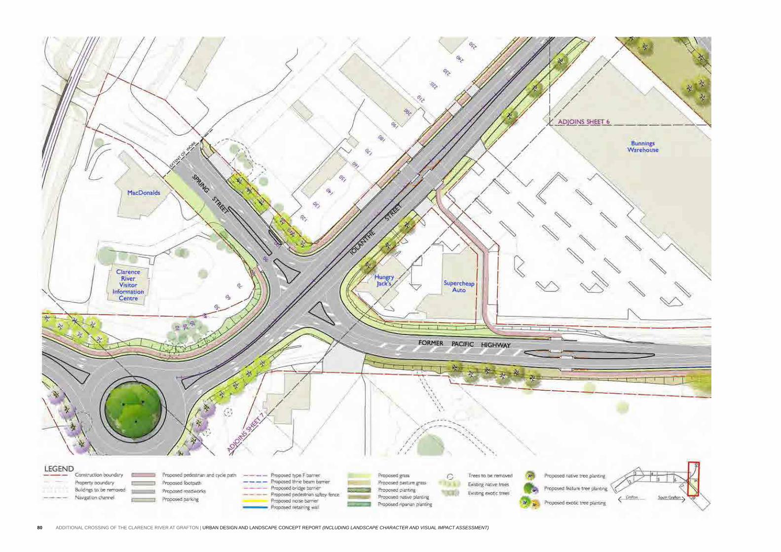
80 ADDITIONAL CROSSING OF THE CLARENCE RIVER AT GRAFTON | URBAN DESIGN AND LANDSCAPE CONCEPT REPORT (INCLUDING LANDSCAPE CHARACTER AND VISUAL IMPACT ASSESSMENT)
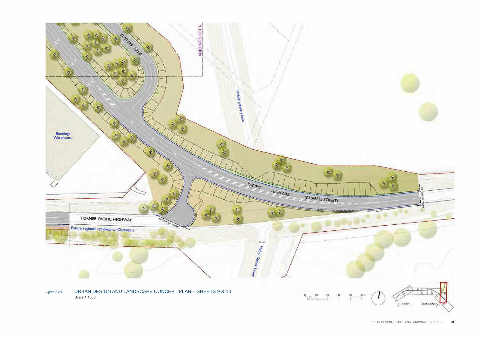
Figure 6.23: Urban Design anD LanDscape concept pLan – sHeets 9 & 10 Scale 1:1000
81Urban Design, briDge anD LanDscape concept
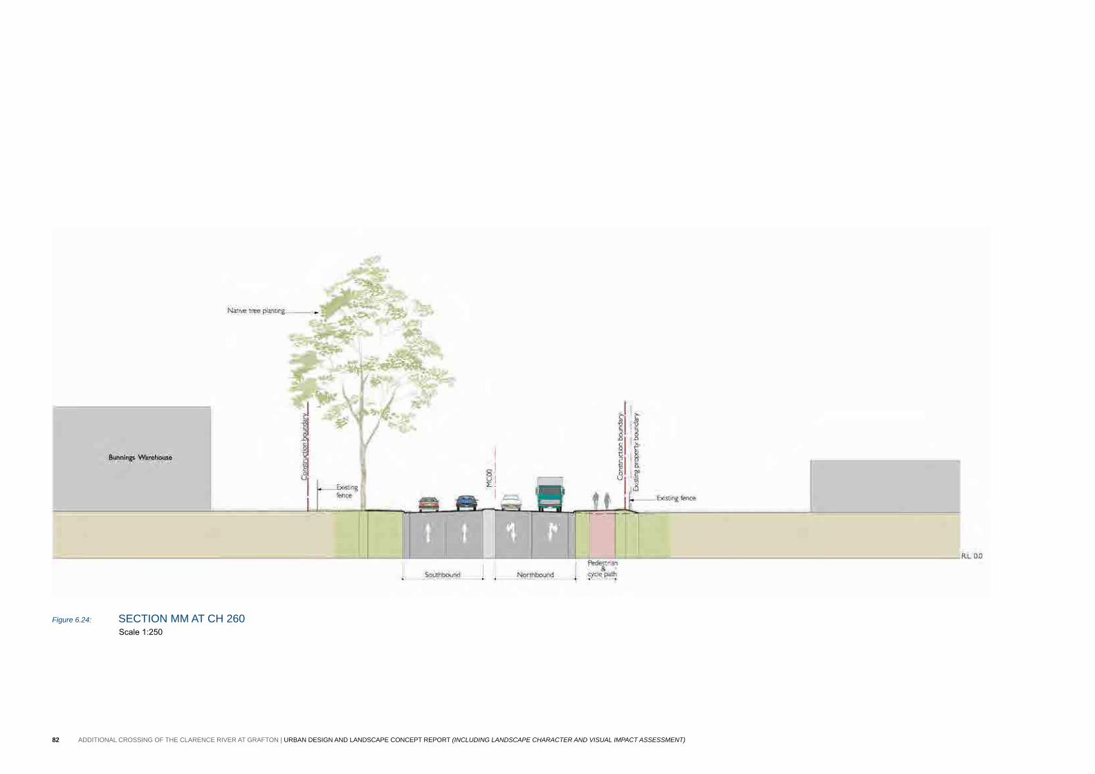
Figure 6.24: section MM at cH 260 Scale 1:250
82 ADDITIONAL CROSSING OF THE CLARENCE RIVER AT GRAFTON | URBAN DESIGN AND LANDSCAPE CONCEPT REPORT (INCLUDING LANDSCAPE CHARACTER AND VISUAL IMPACT ASSESSMENT)
83Urban Design, briDge anD LanDscape concept
6.5 proJect-WiDe recoMMenDations
the following urban design recommendations are provided for the project-wide structures and roadside elements as they can contribute positively to the character of both the roadway and the local landscape. These recommendations would be refined further during detailed design and inform the urban design and landscape plan for the project.
CUTTINGS AND FILL EMBANKMENTS Cuttings and fill embankments are required to reconcile the upgraded bridge approach road levels with existing ground levels. they are required due to the necessary elevated level of the bridge that addresses flooding and navigational requirements and the minimum geometric requirements for the horizontal and vertical road alignment to meet the relevant design standards.
The types of earthworks formations required for this proposal are:
• cuttings - where greaves street, which would be been lowered to achieve clearance heights, would be situated below the existing ground, requiring excavation.
• Fill embankments - where the approach roads on both sides of the river would be situated above the existing ground, requiring the road to be elevated.
Urban design recommendations • turf the cutting at greaves street. • the use of shotcrete is to be avoided unless absolutely necessary.
Where shotcrete is required, its application is to be designed to minimise its visibility. techniques include matching the colour of the concrete to the surrounding rock, and recessing the shotcrete from the cutting face. refer the roads and Maritime shotcrete Design guidelines.
Rationale • Turfing stabilises the cutting and integrates with adjoining
treatments.
Fill embankments do not generally impact on the road user as they are located below the road level. they do however provide, through the elevation of the road, an opportunity to promote views of the broader landscape. Views of the fill embankment from the broader landscape also need to be considered.
• embankments should be vegetated using species that corresponds to the adjoining landscape.
• Two general responses to landform are recommended:• Where the existing landform is relatively flat and space permits,
provide a flatter embankment profile (4H:1V) or flatter) to better fit with the surrounding landform.
¬ Where the existing landform is steep or where space is limited, provide steeper embankments to minimise extent. in all cases a minimum angle of 2H:1V is preferred to facilitate planting.
• in open areas, limit tree planting to clusters to ensure vistas through to the broader landscape.
Rationale • Views from the road improve the driving experience, sense of place
and orientation. • Views of the road can be improved where the embankments
are integrated with the existing landscape through shaping and revegetation.
• Flattening of batters creates a larger surface area of revegetation to occur. Do not flatten batters where additional tree loss would result as existing trees provide better initial screening than new revegetation.
• revegetation of embankments allows for better integration of the embankments with the character of the surrounding landscape. this is further improved where vegetation is matched to the surrounding vegetation.
PEDESTRIAN AND CYCLE PATHSa 2.5 metre wide pedestrian and cycle path is proposed to link grafton and south grafton (and the existing coastline cycleway) via the new bridge. it would be separated from the carriageway, and in some situations, fenced.
Urban design recommendations • Investigate alternative concrete finish options to reduce glare. • provide exposed aggregate thresholds, with adequate tonal variation,
to alert cyclists to upcoming intersections. • provide fencing to the top of embankments only. in higher speed
environments, provide W beam barriers only next to the road.• provide turf next to the path. if planting is to be provided, allow a
300-500 millimetre setback.
Rationale • a separated pedestrian and cycle path provides maximum safety and
amenity to path users.
SAFETY BARRIERSRoad safety barriers are required at the top of fill embankments and in other roadside situations. the preferred type of barrier depends on the location.
Urban design recommendations• in general, full height concrete barriers are to be avoided as they
restrict views to the surrounding landscape.
• either W beam guard rail or wire rope barrier, as appropriate for the situation. either barrier type should preferably be used in conjunction with planting behind.
• Where space is limited or where maximum visual transparency is required, the modified concrete barrier (type F) with twin rail bridge barrier should be used.
Rationale• Facilitate views from the road to the surrounding landscape, and to
provide a sense of connection to the local area.
FENCINGFencing is required next to the pedestrian and cycle path, at the top of fill embankments, for safety requirements.
Urban design recommendations• investigate alternative fencing types and colour to minimise the visual
impact of fencing.
Rationale• reduce the visual dominance of balustrades. • provides transparency to allow for adjoining vegetation to add to the
character of pathways and roadways.
STREET LIGHTINGUrban design recommendations• Lighting to be minimised to meet requirements set out in as1158.• ensure uniformity in size, height and spacing of lights. • Use galvanised steel light posts in black or dark grey finish.
Rationale• reduce visual dominance of the works, and to retain the existing
town character.
SIGNAGEUrban design recommendations• there needs to be a balance of regulatory signage and local
information signage as part of the works, which would be coordinated on a signage plan and subject to urban design review.
• signage would be installed in accordance with relevant roads and Maritime and government guidelines.
Rationale
• the need for signage within the road corridor should be appropriate and suitable within the context of grafton.
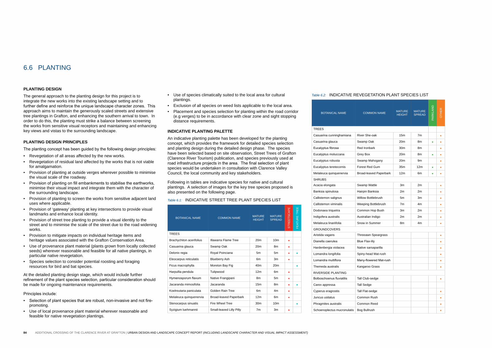
84 ADDITIONAL CROSSING OF THE CLARENCE RIVER AT GRAFTON | URBAN DESIGN AND LANDSCAPE CONCEPT REPORT (INCLUDING LANDSCAPE CHARACTER AND VISUAL IMPACT ASSESSMENT)
PLANTING DESIGNthe general approach to the planting design for this project is to integrate the new works into the existing landscape setting and to further define and reinforce the unique landscape character zones. This approach aims to maintain the generously scaled streets and extensive tree plantings in grafton, and enhancing the southern arrival to town. in order to do this, the planting must strike a balance between screening the works from sensitive visual receptors and maintaining and enhancing key views and vistas to the surrounding landscape.
PLANTING DESIGN PRINCIPLESThe planting concept has been guided by the following design principles: • revegetation of all areas affected by the new works.• revegetation of residual land affected by the works that is not viable
for amalgamation. • provision of planting at outside verges wherever possible to minimise
the visual scale of the roadway. • Provision of planting on fill embankments to stabilise the earthworks,
minimise their visual impact and integrate them with the character of the surrounding landscape.
• provision of planting to screen the works from sensitive adjacent land uses where applicable.
• provision of ‘gateway’ planting at key intersections to provide visual landmarks and enhance local identity.
• provision of street tree planting to provide a visual identity to the street and to minimise the scale of the street due to the road widening works.
• provision to mitigate impacts on individual heritage items and heritage values associated with the grafton conservation area.
• Use of provenance plant material (plants grown from locally collected seeds) wherever reasonable and feasible for all native plantings, in particular native revegetation.
• species selection to consider potential roosting and foraging resources for bird and bat species.
at the detailed planting design stage, which would include further refinement of the plant species selection, particular consideration should be made for ongoing maintenance requirements.
Principles include:• Selection of plant species that are robust, non-invasive and not fire-
promoting.• Use of local provenance plant material wherever reasonable and
feasible for native revegetation plantings.
• Use of species climatically suited to the local area for cultural plantings.
• exclusion of all species on weed lists applicable to the local area. • placement and species selection for planting within the road corridor
(e.g verges) to be in accordance with clear zone and sight stopping distance requirements.
INDICATIVE PLANTING PALETTEan indicative planting palette has been developed for the planting concept, which provides the framework for detailed species selection and planting design during the detailed design phase. the species have been selected based on site observation, street trees of grafton (clarence river tourism) publication, and species previously used at road infrastructure projects in the area. The final selection of plant species would be undertaken in consultation with clarence Valley council, the local community and key stakeholders.
Following in tables are indicative species for native and cultural plantings. a selection of images for the key tree species proposed is also presented on the following page.
Table 6.1: inDicatiVe street tree pLant species List
botanicaL naMe coMMon naMe MatUre HeigHt
MatUre spreaD
str
ee
tsc
ap
e
Feat
Ur
e t
re
e
trees
brachychiton acerifolius illawarra Flame tree 20m 10m •casuarina glauca swamp oak 20m 8m •Delonix regia royal poinciana 5m 5m • •eleocarpus reticulatis blueberry ash 6m 3m •Ficus macrophylla Moreton bay Fig 40m 20m •Harpullia pendula tulipwood 12m 6m •Hymenosporum flavum native Frangipani 8m 5m •Jacaranda mimosifolia Jacaranda 15m 8m • •Koelreutaria paniculata golden rain tree 6m 4m •Melaleuca quinquenervia broad-leaved paperbark 12m 6m •stenocarpus sinuatis Fire Wheel tree 30m 10m •syzigium luehmannii small-leaved Lilly pilly 7m 3m •
6.6 pLanting
Table 6.2: inDicatiVe reVegetation pLant species List
botanicaL naMe coMMon naMe MatUre HeigHt
MatUre spreaD
par
KLa
nD
otH
er
trees
casuarina cunninghamiana river she-oak 15m 7m •casuarina glauca swamp oak 20m 8m • •Eucalyptus fibrosa red ironbark 30m 8m •eucalyptus moluccana grey box 20m 8m • •eucalyptus robusta swamp Mahogany 20m 9m •eucalyptus teretecornis Forest red gum 35m 12m • •Melaleuca quinquenervia broad-leaved paperbark 12m 6m • •sHrUbs
acacia elongata swamp Wattle 3m 2m •banksia spinulosa Hairpin banksia 2m 2m •callistemon salignus Willow bottlebrush 5m 3m •callistemon viminalis Weeping bottlebrush 7m 4m •Dodonaea triquetra common Hop bush 3m 2m •indigofera australis australian indigo 2m 2m •Melaleuca linariifolia snow in summer 8m 4m •groUnDcoVers
aristida vagans threeawn speargrass •Dianella caerulea blue Flax-lily •Hardenbergia violacea native sarsaparilla •Lomandra longifolia spiny-head Mat-rush •Lomandra multiflora Many-flowered Mat-rush •themeda australis Kangaroo grass •riVersiDe pLanting
Bolboschoenus fluviatilis tall club-sedge •carex appressa tall sedge
cyperus eragrostis tall Flat-sedge •Juncus usitatus common rush •phragmites australis common reed •schoenoplectus mucronulatis bog bullrush •

85Urban Design, briDge anD LanDscape concept
Melaleuca quinquenervia (broad-leaved paperbark) casuarina glauca (swamp oak)
Jacaranda mimosifolia (Jacaranda)
stenocarpus sinuatis (Fire Wheel tree)
Delonix regia (royal poinciana)brachychiton acerifolius (ilawarra Flame tree)
Hymenosporum flavum (Native Frangipani)
Koelreutaria paniculata (golden rain tree)Ficus macrophylla (Moreton bay Fig)
eucalyptus tereticornis (Forest red gum)

86 ADDITIONAL CROSSING OF THE CLARENCE RIVER AT GRAFTON | URBAN DESIGN AND LANDSCAPE CONCEPT REPORT (INCLUDING LANDSCAPE CHARACTER AND VISUAL IMPACT ASSESSMENT)
this page has been left intentionally blank.