Embed Size (px)
Citation preview
Proceedings, 6th African Rift Geothermal Conference
Addis Ababa, Ethiopia, 2nd
– 4th November 2016
1
2D INVERSION OF MT DATA TO DELINEATE THE RESISTIVITY
STRUCTURE OF KIBIRO GEOTHERMAL PROSPECT, UGANDA
Eriya Kahwa, Geraldine P. Babirye, Nelson R. Birungi and Joseph Nyago
Ministry of Energy and Mineral Development
P.O.Box 9, Entebbe
UGANDA
Key words: Magnetotelluric, electromagnetic, resistivity
ABSTRACT
The first geophysical surveys in the Kibiro geothermal prospect were carried out in 2004. The aim of
the study was to delineate the areal extent of the geothermal reservoir and come up with a geophysical
conceptual model of the area. The Kibiro geothermal prospect is located in the western arm of the
East African Rift system in Hoima District, Western Uganda. The prospect is traversed by the
Bunyoro-Tooro fault/escarpment with crystalline basement rocks comprising granites, gneisses and
amphibolite intrusives on the eastern side and younger Pleistocene sediments on the western side. The
geothermal surface manifestations are hot springs with a maximum surface temperature of 86.5˚C and
are located on the contact between the crystalline basement rock and the sediments. TEM resistivity
surveys carried out in 2004 revealed low resistivity anomalous areas in the crystalline basement which
were tested with shallow temperature gradient drilling and found not to be related to the geothermal
activity at Kibiro. Recent resistivity investigations aimed at delineating the geothermal resource at
Kibiro acquired 65 MT and 44 TEM soundings. The data was analysed using the WinGLink program
for static shift correction and 2D inversion of MT. The results of the 2D inversion; cross-sections and
iso-resistivity maps suggested very high conductivity anomalies in the crystalline basement rocks east
of the Escarpment. A low-resistivity anomaly was traced within the sedimentary basin between the
escarpment and the Lake Albert and possibly extending under the Lake. In the context of sediment-
hosted geothermal reservoir, the unusually low resistivity clay in Kibiro indicates the extent of
sediments affected by hydrothermal alteration. The low resistivity is more likely associated with
alteration from an outflow rather than from upflow, except closer to the North Toro Bunyoro (TNB)
fault.
1. INTRODUCTION
Kibiro geothermal prospect is located in western Uganda on the South East shore of Lake Albert
within the western branch of the East African rift system (Figure 1). The prospect comprises various
surface manifestations including hot springs, travertine, altered ground and clay alteration.
There are various previous geothermal resource assessments done in Kibiro including; surface
exploration surveys; resistivity (TEM), gravity, magnetics, geological mapping, Water chemistry,
Isotope hydrology and drilling of temperature gradient wells. Earlier geophysical analyses of Kibiro
prospect focused majorly on seeking a magmatic source that was expected based on the reported 2500
geothermometry and sulfur deposition (Ármannsson, 1994).
Earlier surface exploration surveys at Kibiro (Gíslason et al., 2004) including TEM resistivity survey
showed sharp anomalies anomalies of low resistivity in the metamorphic basement rocks, which
generally have very high resistivities. Six temperature gradient wells were drilled in the anomalous
basement rock of the escarpment, south of Kibiro. Downhole temperatures logged in the wells
indicted measured temperature was about 350C measured at the bottom and the measured thermal
gradient was much lower than expected, between 17-35 0C/km, consistent with the global continental
Kahwa et al.
2
average thermal gradient of about 25 to 300C/km. This showed that the low-resistivity anomalies in
the basement rocks were not caused by a heat source (Árnason & Gíslason, 2009).
The Directorate of Geological Survey and Mines (DGSM) with assistance of Geothermal
Development Company (GDC) and technical support of UNEP collected MT, TEM and other
geoscientific data at Kibiro in November 2015 and thereafter additional infill in March, 2016.The
surveys were aimed at; collecting and interpretation of new geoscientific (geological, geochemical,
and geophysical) data and thereafter develop an integrated conceptual model for Kibiro with a view to
target sites for possible exploration wells.
The electromagnetic methods that include magnetotelluric (MT) and transient electromagnetic (TEM)
are techniques of choice when it comes to geothermal exploration. This is because they give indirect
information about the sub-surface, in terms of the resistivity structure of geothermal systems that may
be connected to temperature and other components of interest. A total of 65 MT and 44 TEM
soundings are used in this interpretation.
The MT method suffers from the static shift problem. This is an inherent uncertainty in the MT data,
caused mainly by local near-surface resistivity heterogeneities close to the sounding site (Sternberg et
al., 1988; Árnason, 2008). This phenomenon cannot be resolved using MT data alone. The static shift
is expressed by scaling of the apparent resistivity by an unknown factor (shifted on log scale), so that
apparent resistivity curves plot parallel to their true level. The TEM method does not suffer this
problem, therefore joint inversion of TEM and MT soundings done at the same or close location has
been used to determine and correct for the static shift in the MT data. Given the very strong 2D strike
of the geology and the MT data, Kibiro prospect is unusually well suited to 2D inversion (Alexander
et al. 2016).
Figure 1: Location map of the Kibiro prospect (Chorowicz, 2005)
Kibiro
Kahwa et al.
3
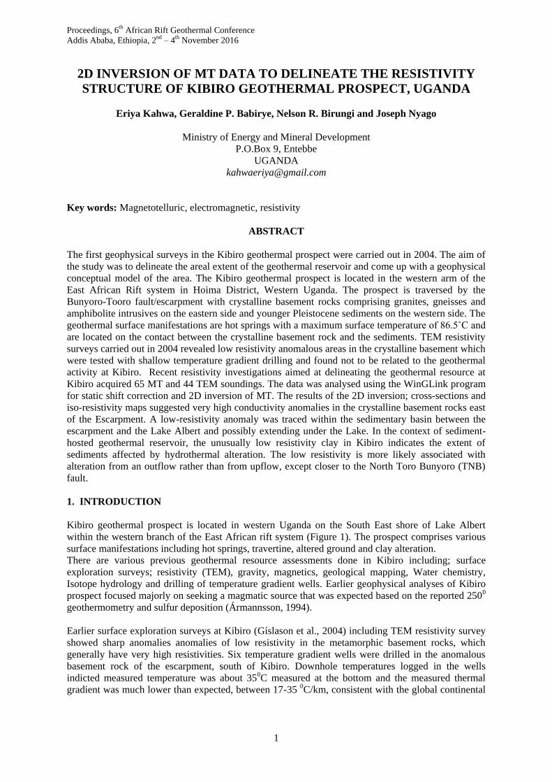
2. GEOLOGIC SETTING
Geologically, Kibiro is divided into two major settings by the escarpment that cuts through the field
from SW to NE. To the east, the geology is dominated by ancient crystalline basement, characterized
by granites and granitic gneisses, whereas within the rift itself are thick sequences of sediments
majorly, composed of sand, silt and gritty sandstone (Figure 2).
The basement rock granite and gneisses varies in appearance from fine grained to coarse grained with
quartz and feldspars being the main minerals, but biotite and amphibolite are also present. Banding is
common (although sometimes absent), and sometimes the rock can be classified as granitic-gneiss.
The banding is more pronounced closer to the escarpment, and usually the bedding is dipping very
steeply (60-900), and the most common direction of the strike is close to N200 E although E-W
direction is also common (Gíslason et al.2004). The sediments are predominantly clastic sediments,
commonly fluvial and lacustrine deposits (Morley et al., 1999).
The Kibiro hot springs discharge from sediments at the foot of the south-eastern escarpment of the
Lake Albert rift (the northernmost rift basin of the western branch). Extension-related normal faulting
has resulted in significant topographic features; the footwall rises more than 350 m above rift basin.
Figure 2: Regional geology of the Western arm of the East African Rift System (Ring, 2008)
Kibiro
Kahwa et al.
4
3. METHODOLOGY
3.1.1. MT & TEM data acquisition and data processing.
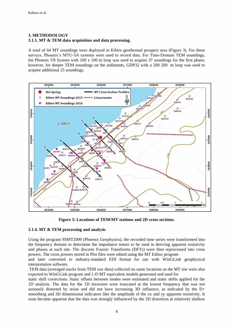
A total of 64 MT soundings were deployed in Kibiro geothermal prospect area (Figure 3). For these
surveys, Phoenix’s MTU-5A systems were used to record data. For Time-Domain TEM soundings,
the Phoenix V8 System with 100 x 100 m loop was used to acquire 37 soundings for the first phase;
however, for deeper TEM soundings on the sediments, GDP32 with a 200 200 m loop was used to
acquire additional 25 soundings.
Figure 3: Locations of TEM/MT stations and 2D cross sections.
3.1.4. MT & TEM processing and analysis
Using the program SSMT2000 (Phoenix Geophysics), the recorded time series were transformed into
the frequency domain to determine the impedance tensor to be used in deriving apparent resistivity
and phases at each site. The discrete Fourier Transforms (DFTs) were then reprocessed into cross
powers. The cross powers stored in Plot files were edited using the MT Editor program
and later converted to industry-standard EDI format for use with WinGLink geophysical
interpretation software.
TEM data (averaged stacks from TEM raw data) collected on same locations as the MT site were also
exported to WinGLink program and 1-D MT equivalent models generated and used for
static shift corrections. Static offsets between modes were estimated and static shifts applied for the
1D analysis. The data for the 1D inversion were truncated at the lowest frequency that was not
seriously distorted by noise and did not have increasing 3D influence, as indicated by the D+
smoothing and 3D dimensional indicators like the amplitude of the xx and yy apparent resistivity. It
soon became apparent that the data was strongly influenced by the 2D distortion at relatively shallow
Kahwa et al.
5
depth. Therefore, the MT was aligned into profiles perpendicular to strike, the data were rotated to
45o azimuth and 2D inversions were completed.
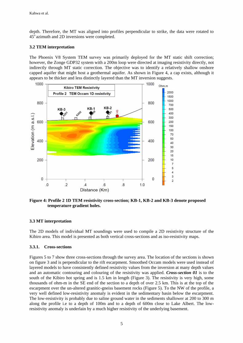
3.2 TEM interpretation
The Phoenix V8 System TEM survey was primarily deployed for the MT static shift correction;
however, the Zonge GDP32 system with a 200m loop were directed at imaging resistivity directly, not
indirectly through MT static correction. The objective was to identify a relatively shallow onshore
capped aquifer that might host a geothermal aquifer. As shown in Figure 4, a cap exists, although it
appears to be thicker and less distinctly layered than the MT inversion suggests.
Figure 4: Profile 2 1D TEM resistivity cross-section; KB-1, KB-2 and KB-3 denote proposed
temperature gradient holes.
3.3 MT interpretation
The 2D models of individual MT soundings were used to compile a 2D resistivity structure of the
Kibiro area. This model is presented as both vertical cross-sections and as iso-resistivity maps.
3.3.1. Cross-sections
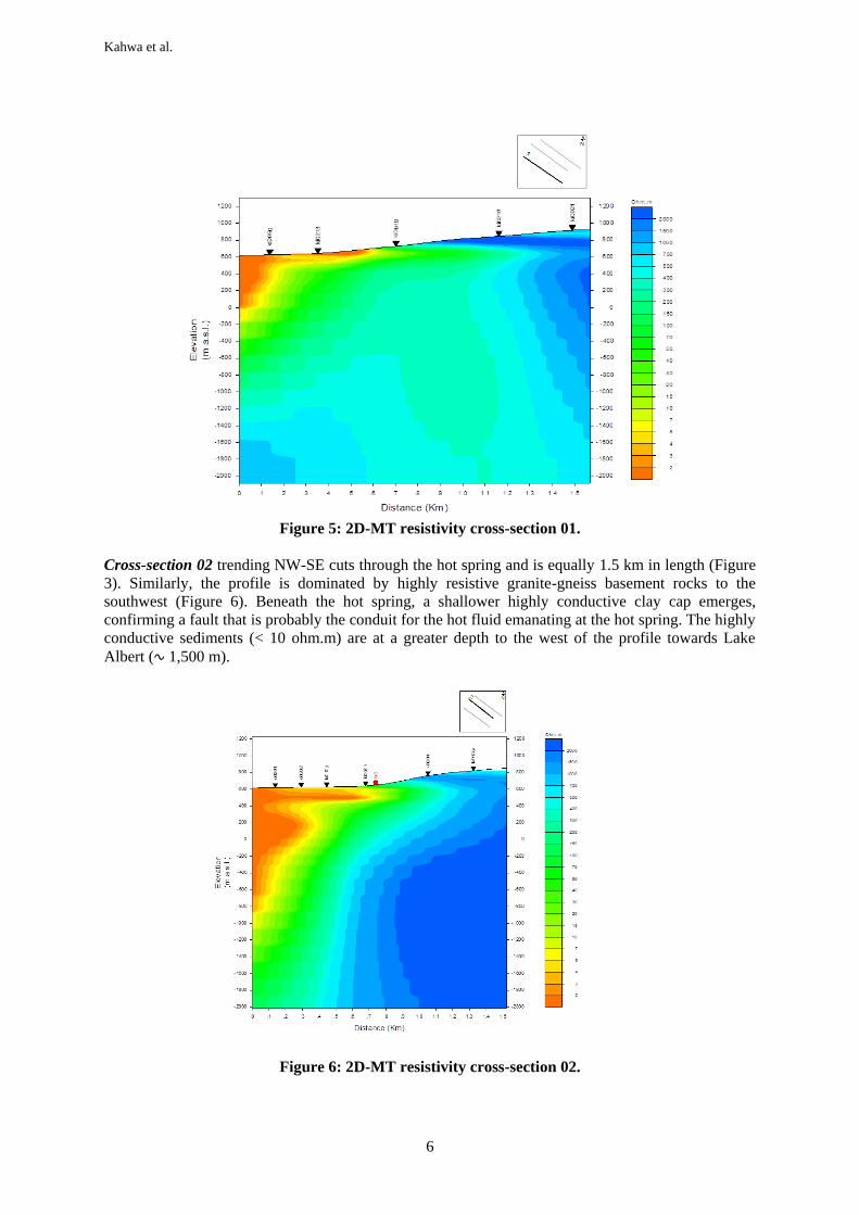
Figures 5 to 7 show three cross-sections through the survey area. The location of the sections is shown
on figure 3 and is perpendicular to the rift escarpment. Smoothed Occam models were used instead of
layered models to have consistently defined resistivity values from the inversion at many depth values
and an automatic contouring and colouring of the resistivity was applied. Cross-section 01 is to the
south of the Kibiro hot spring and is 1.5 km in length (Figure 3). The resistivity is very high, some
thousands of ohm-m in the SE end of the section to a depth of over 2.5 km. This is at the top of the
escarpment over the un-altered granitic-gneiss basement rocks (Figure 5). To the NW of the profile, a
very well defined low-resistivity anomaly is evident in the sedimentary basin below the escarpment.
The low-resistivity is probably due to saline ground water in the sediments shallower at 200 to 300 m
along the profile i.e to a depth of 100m and to a depth of 600m close to Lake Albert. The low-
resistivity anomaly is underlain by a much higher resistivity of the underlying basement.
Kahwa et al.
6
Figure 5: 2D-MT resistivity cross-section 01.
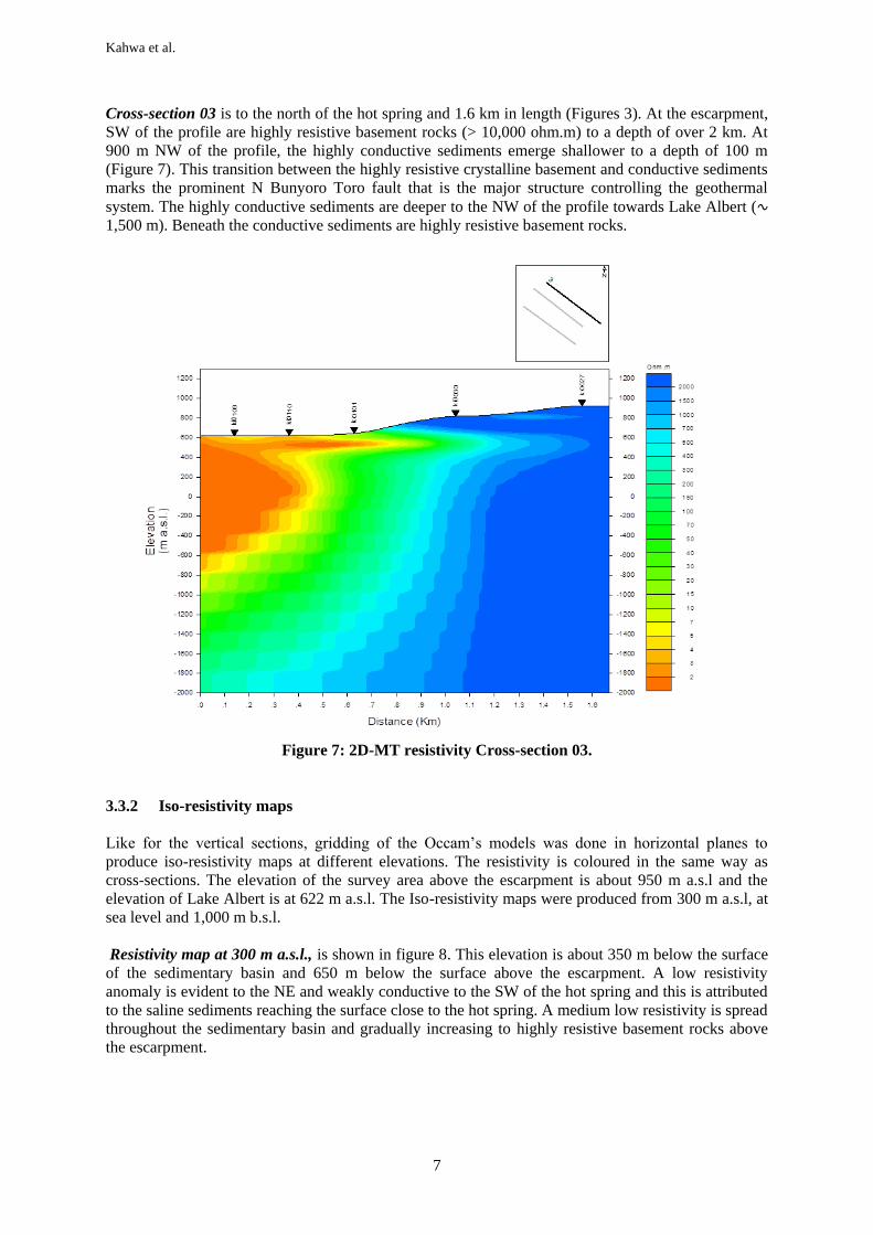
Cross-section 02 trending NW-SE cuts through the hot spring and is equally 1.5 km in length (Figure
3). Similarly, the profile is dominated by highly resistive granite-gneiss basement rocks to the
southwest (Figure 6). Beneath the hot spring, a shallower highly conductive clay cap emerges,
confirming a fault that is probably the conduit for the hot fluid emanating at the hot spring. The highly
conductive sediments (< 10 ohm.m) are at a greater depth to the west of the profile towards Lake
Albert (∿ 1,500 m).
Figure 6: 2D-MT resistivity cross-section 02.
Kahwa et al.
7
Cross-section 03 is to the north of the hot spring and 1.6 km in length (Figures 3). At the escarpment,
SW of the profile are highly resistive basement rocks (> 10,000 ohm.m) to a depth of over 2 km. At
900 m NW of the profile, the highly conductive sediments emerge shallower to a depth of 100 m
(Figure 7). This transition between the highly resistive crystalline basement and conductive sediments
marks the prominent N Bunyoro Toro fault that is the major structure controlling the geothermal
system. The highly conductive sediments are deeper to the NW of the profile towards Lake Albert (∿
1,500 m). Beneath the conductive sediments are highly resistive basement rocks.
Figure 7: 2D-MT resistivity Cross-section 03.
3.3.2 Iso-resistivity maps
Like for the vertical sections, gridding of the Occam’s models was done in horizontal planes to
produce iso-resistivity maps at different elevations. The resistivity is coloured in the same way as
cross-sections. The elevation of the survey area above the escarpment is about 950 m a.s.l and the
elevation of Lake Albert is at 622 m a.s.l. The Iso-resistivity maps were produced from 300 m a.s.l, at
sea level and 1,000 m b.s.l.
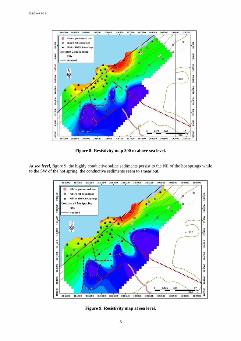
Resistivity map at 300 m a.s.l., is shown in figure 8. This elevation is about 350 m below the surface
of the sedimentary basin and 650 m below the surface above the escarpment. A low resistivity
anomaly is evident to the NE and weakly conductive to the SW of the hot spring and this is attributed
to the saline sediments reaching the surface close to the hot spring. A medium low resistivity is spread
throughout the sedimentary basin and gradually increasing to highly resistive basement rocks above
the escarpment.
Kahwa et al.
8
Figure 8: Resistivity map 300 m above sea level.
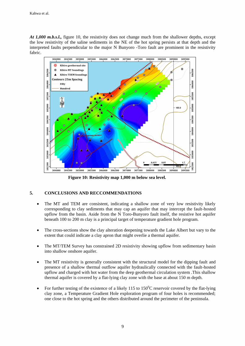
At sea level, figure 9, the highly conductive saline sediments persist to the NE of the hot springs while
to the SW of the hot spring; the conductive sediments seem to smear out.
Figure 9: Resistivity map at sea level.
Kahwa et al.
9
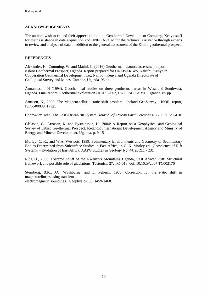
At 1,000 m.b.s.l., figure 10, the resistivity does not change much from the shallower depths, except
the low resistivity of the saline sediments in the NE of the hot spring persists at that depth and the
interpreted faults perpendicular to the major N Bunyoro -Toro fault are prominent in the resistivity
fabric.
Figure 10: Resistivity map 1,000 m below sea level.
5. CONCLUSIONS AND RECCOMMENDATIONS
The MT and TEM are consistent, indicating a shallow zone of very low resistivity likely
corresponding to clay sediments that may cap an aquifer that may intercept the fault-hosted
upflow from the basin. Aside from the N Toro-Bunyoro fault itself, the resistive hot aquifer
beneath 100 to 200 m clay is a principal target of temperature gradient hole program.
The cross-sections show the clay alteration deepening towards the Lake Albert but vary to the
extent that could indicate a clay apron that might overlie a thermal aquifer.
The MT/TEM Survey has constrained 2D resistivity showing upflow from sedimentary basin
into shallow onshore aquifer.
The MT resistivity is generally consistent with the structural model for the dipping fault and
presence of a shallow thermal outflow aquifer hydraulically connected with the fault-hosted
upflow and charged with hot water from the deep geothermal circulation system .This shallow
thermal aquifer is covered by a flat-lying clay zone with the base at about 150 m depth.
For further testing of the existence of a likely 115 to 1500C reservoir covered by the flat-lying
clay zone, a Temperature Gradient Hole exploration program of four holes is recommended;
one close to the hot spring and the others distributed around the perimeter of the peninsula.
Kahwa et al.
10
ACKNOWLEDGEMENTS
The authors wish to extend their appreciation to the Geothermal Development Company, Kenya staff
for their assistance in data acquisition and UNEP/ARGeo for the technical assistance through experts
to review and analysis of data in addition to the general assessment of the Kibiro geothermal prospect.
REFERENCES
Alexander, K., Cumming, W. and Marini, L. (2016) Geothermal resource assessment report –
Kibiro Geothermal Prospect, Uganda. Report prepared for UNEP/ARGeo, Nairobi, Kenya in
Cooperation Geothermal Development Co., Nairobi, Kenya and Uganda Directorate of
Geological Survey and Mines, Entebbe, Uganda, 95 pp.
Ármannsson, H (1994). Geochemical studies on three geothermal areas in West and Southwest,
Uganda. Final report. Geothermal exploration UGA/92/003, UNDESD, GSMD, Uganda, 85 pp.
Árnason, K., 2008: The Magneto-telluric static shift problem. Iceland GeoSurvey - ISOR, report,
ISOR-08088, 17 pp.
Chorowicz Jean: The East African rift System. Journal of African Earth Sciences 43 (2005) 379–410
Gíslason, G., Árnason, K. and Eysteinsson, H., 2004: A Report on a Geophysical and Geological
Survey of Kibiro Geothermal Prospect. Icelandic International Development Agency and Ministry of
Energy and Mineral Development, Uganda. p. 9-15
Morley, C. K., and W.A. Westcott, 1999: Sedimentary Environments and Geometry of Sedimentary
Bodies Determined from Subsurface Studies in East Africa, in C. K. Morley ed., Geoscience of Rift
Systems – Evolution of East Africa: AAPG Studies in Geology No. 44, p. 211 - 231.
Ring U., 2008. Extreme uplift of the Rwenzori Mountains Uganda, East African Rift: Structural
framework and possible role of glaciations. Tectonics, 27, TC4018, doi: 10.1029/2007 TC002176
Sternberg, B.K., J.C. Washburne, and L. Pellerin, 1988: Correction for the static shift in
magnetotellurics using transient
electromagnetic soundings. Geophysics, 53, 1459-1468.