Embed Size (px)
Citation preview

Introduction and Basin GeologyOver the past few years, tying 2D and 3D seismic datasets to a comprehensive well dataset in the Hoop-Fingerdjupet Basin of the Norwegian Barents Sea has allowed the regional stratigraphy and hydrocarbon prospectivity of the West Barents Sea to be clearly delineated.
The key elements of the petroleum system comprise regionally extensive regional source rocks, reservoirs and seals at multiple levels. Reservoir-seal pairs are represented in the Permo-Carboniferous carbonate and evaporite systems, and also in overlying clastic deposits of the Triassic and Jurassic deltaic systems (Henriksen et al. 2012). Traps comprising large folded structures, salt domes and diapirs and extensional tilted fault blocks are well imaged, as are the sequence-stratigraphic relationships in Carboniferous-Jurassic section.
Hydrocarbon charge is provided by Permo-Carboniferous source rocks, which reached oil-generative maturity early as the Triassic. Early migrated oil was initially reservoired in Triassic clastic deltaic structural and stratigraphic traps, many of which have been able to keep their integrity during the later tectonics. However, leakage from such structures, some occurring very recently, has charged overlying and adjacent Jurassic reservoirs. Examples of this are the Caurus, Obesum and Wisting discoveries where light oil has been encountered in very shallow reservoirs, suggesting very recent re-migration.
Risk assessment and Seismic InversionRisk assessment of prospects in the Hoop area highlights primary uncertainty on either trap integrity (seal/breach) or charge (migration). Due to the complexities understanding and predicting the efficacy of the re-migrated oil charge mechanism for prospects in the Hoop area, seismic attribute analysis focused on Direct Hydrocarbon Indicators (such as AVA/AVO analysis) can be a the key tool in exploration
risk reduction. However, the ability to use seismic data to extrapolate laterally from offset wells in combination with fluid substitution modelling can be affected by a number of factors such as the wavelet extraction at the well tie and the source de-signature related to the seismic processing. Only with good input data can the evaluation of Acoustic Impedance and VP/VS (P-wave velocity and Estimated S-wave velocity) background, from which the reservoir anomaly will be defined, be confidently undertaken.
A regional approach has been undertaken to develop products able to model regionally the geological and physical (i.e. elastic) properties of the sequences in the Hoop Basin, in order to obtain a petrophysical background for key reservoir horizons. The elastic properties obtained using AVO inversion are applied in a rock physics inversion which links the petrophysical properties such as shale content, water saturation, porosity and pore pressure to the elastic properties (Rasmussen et al. 2005). This analysis can be integrated with case-histories, to constrain extrapolation into undrilled prospects. In addition, regional AVO inversion can be integrated with other geophysical techniques as CSEM (Controlled Source Electro Magnetic) (Paydayesh et al. 2014) or IP (Induced Polarization).
Seismic Inversion Reduces Exploration RiskHoop-Fingerdjupet Area, Barents Sea
Fig. 1 The map shows the location of the 2D seismic survey available for the regional simultaneous inversion in the Hoop-Fingerdjupet area (yellow and white lines).
P. Esestime1*, M.E. Nielsen2, K. Rodriguez1, N. Hodgson1
1=Spectrum, 2= Qeye Labs ApS
2D Simultaneous AVO InversionNew 2D seismic survey in 2013 in the Hoop Basin has provided an excellent opportunity to develop 2D regional seismic inversion (Fig.1). The survey has been acquired with a long offset cable of 8000 m, to enhance the signal/noise in the stacking process. The very high seismic fold of the survey (162 fold), and the relatively shallow target depth (0.8-3 sec TWT), allow the extraction f angle stacks from 0 to 36 deg. The data are particularly suited to this analysis as the NMO (Normal Move Out velocity) is reliable and the Signal/Noise is high. Both these parameters are normally challenging in the West Barents Sea, due to high shallow velocities and low Acoustic Impedance contrasts (reflectivity) in the Triassic and Jurassic stratigraphy.
A global seismic AVO inversion algorithm has been used to invert the seismic angle stacks directly for acoustic impedance, Vp/Vs or shear impedance, and density. Input to the simultaneous AVO inversion is the seismic data, a wavelet for each seismic angle stack and a low-frequency model for each property to be inverted. An Aki-Richard approximation model is used for the AVO inversion. The inversion allows for parameterization in any meaningful combination of elastic parameters (e.g., Acoustic Impedance, Vp/Vs and density) (Rasmussen et
al. 2004). Estimation of acoustic impedance and Vp/Vs improves the discrimination between different lithology and fluids.
The wavelet estimation is a crucial step in the seismic inversion work flow. Independent wavelets are estimated for each seismic angle stack, which implies that any variations in amplitude, frequency and phase between the angle stacks will be captured by the wavelet (Rasmussen et al. 2004). Using a unique wavelet for each input angle stack enables the inversion to effectively compensate for these offset-dependent phases and amplitudes. Deterministic wavelets can be extracted by de-convolution of the seismic trace with the angle reflections in a well. In the absence of adequate well data, a statistical wavelet can be estimated by making certain assumptions on phase and amplitude.
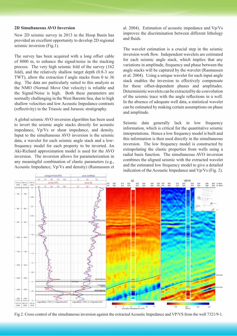
Seismic data generally lack in low frequency information, which is critical for the quantitative seismic interpretations. Hence a low frequency model is built and this information is then used directly in the simultaneous inversion. The low frequency model is constructed by extrapolating the elastic properties from wells using a radial basis function. The simultaneous AVO inversion combines the aligned seismic with the extracted wavelet and the estimated low frequency model to give a detailed indication of the Acoustic Impedance and Vp/Vs (Fig. 2).
Fig 2. Cross-control of the simultaneous inversion against the extracted Acoustic Impedance and VP/VS from the well 7321/9-1.

ResultsHere we demonstrate the results of calibrating the simultaneous inversion technique against the known wells, revealing potential DHI characteristics of a number of plays, in structural and stratigraphic prospects of Jurassic to Permian age in this basin.
ConclusionRegional simultaneous inversion, on good 2D seismic data, allows the modeling of stratigraphic and structural heterogeneities, and it increases the confidence in the reconnaissance of potential hydrocarbon signature, de-risking the delineation of prospects in the Barents Sea.
AcknowledgementsWe thank the Q-eye Lab. for performing the seismic inversion and Spectrum Geo Ltd. for the excellent acquisition and processing delivered.
ReferencesHenriksen, E., Ryseth, A.E., Larssen, G.B., Heide, T., Rønning, K., Sollid, K. and Stoupakova, A. V., 2012 Tectonostratigrahy of the greater Barents Sea: implication for petroleum systems. Geological Society, London, Memoirs, No 35, 163-165.Paydayesh, M., Leathard, M., Ceci, F. and Kumar Sharma, A., 2014 Multi-disciplinary integration of seismic interpretation, AVO inversion and CSEM in the West Loppa exploration. First Break, 32, 87-93.Rasmussen, K.B., Bruun, A. and Pedersen J.M. 2004 Simultaneous Seismic Inversion. Seismic Inversion and Attributes. 66th EAGE Conference & Exhibition.Rasmussen, K.B., Hansen, H.J., Gommensen, L. and Strønen, L.K., 2005 4D Quantitative Estimation of Dynamic Reservoir Properties for the Gullfaks Field., Time Lapse Seismic 3 67th EAGE Conference & Exhibition.Smith, B.A., Guilbot, J., Pirera, F., Sabra, H., Rasmussen, K.B and Davies, D.J. 2003 Detailed Low-Frequency Modeling for Improved Acoustic Impedance inversion at Ekofisk. Case Histories in Field Development. 65th EAGE Conference & Exhibition.
About Spectrum
Spectrum provides innovative Multi-Client seismic surveys and high-quality seismic imaging services to the global oil and gas in-dustry from offices in the UK, Norway, USA, Egypt, Australia, Indonesia and Singapore. Spectrum designs, acquires and processes seismic data to deliver high quality solutions through its dedicated and experienced workforce.
Spectrum holds one of the world’s largest libraries of Multi-Client 2D marine seismic data. The company’s strategy focuses on both the major, established hydrocarbon-producing regions of the world as well as key frontier areas identified by our experienced team of geoscientists. The Spectrum library of Multi-Client data contains projects from many of the foremost oil producing regions of the world. These include new acquisition, reprocessing and interpretation reports.
www.spectrumasa.com