Embed Size (px)
Citation preview
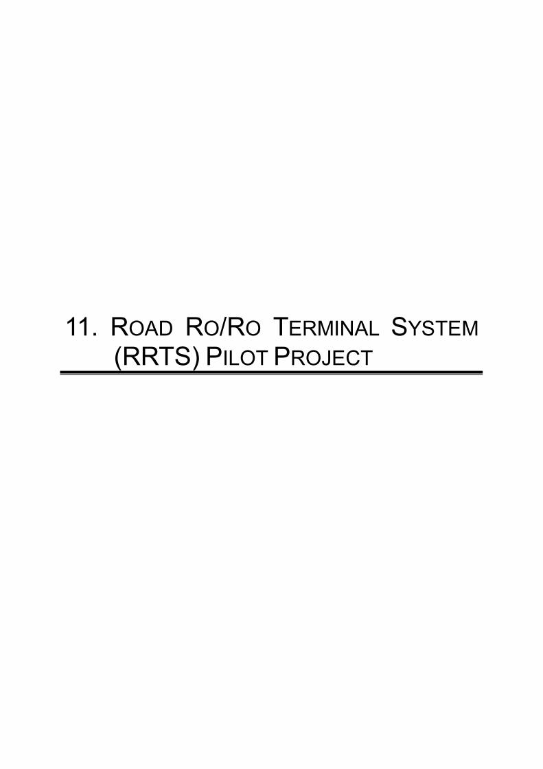
11. ROAD RO/RO TERMINAL SYSTEM (RRTS) PILOT PROJECT
JICA-MARINA The Study on Domestic Shipping Development Plan in the Philippines (DSDP)
Final Report
11-1
11. ROAD RORO TERMINAL SYSTEM (RRTS) PILOT PROJECT
11.1 Introduction
11.1.1 Objectives of the Pilot Project
The main objective of the Pilot Project is to develop a short-haul RoRo (Roll-on/ Roll-off) service for the selected routes from the identified 18 missionary routes. However, it must be clarified at the outset that the Pilot Project is not constrained by the specific ports in the identified missionary routes, but more on the hinterlands of the routes, as the study considers the actual physical characteristics, e.g., bathymetric, road access, etc., of the selected sites. The study also looks at the development of the pilot project as it relates to the total national logistic chain. It is also assumed that DSMP II fund would be available for the pilot project through NMEC is in place a ship leasing service.
The study takes a holistic outlook on the development of the project, looking at the development of the RoRo service with ports and port facilities and the design and shipbuilding of appropriate RoRo vessel for the service based on the demand forecast. However, it must be stressed that the results and recommendations of this study are not prescriptive upon the agencies involved in RRTS development, but rather as inputs for further refinement and prioritization of the RRTS network.
During the course of the study the team conducted field surveys and collaborated with major stakeholders, such as LGUs, long distance bus companies, RoRo vessel operators, RoRo port operators, port users (passengers, shippers, and truck drivers) and various national government agencies in July, 2005.
11.1.2 Context of the Project
(2) ROLL-ON/ROLL-OFF TRANSPORT SYSTEM
Being an archipelagic country, the Philippines would really be dependent on a roll-on, roll-off transport system for the efficient movement of goods and people within the country. Although this is quite self-evident, it took quite a while for the RoRo transport system to take off. The first RoRo connections were the Matnog-Allen, Liloan-Lipata and Batangas-Calapan routes.
The first two routes were developed as part of the Pan Philippine Highway connecting the northern part of Luzon all the way down to Mindanao. The OECF loan for the Pan-Philippine Highway project also included the procurement of two RoRo vessels, Maharlika I and II, which were deployed in the two RoRo links.
Batangas-Calapan developed naturally because of the heavy trading between the island of Mindoro and Metro Manila (Mindoro is the fruit basket and emerging rice granary of Metro Manila) and the close proximity of the two ports.
Over the years, several RoRo routes were developed, so much so that there are already many routes. To further develop the RoRo transport system in the country and harness its inherent advantages in island-to-island movement, the government undertook several studies. It is quite interesting to note that the Government of Japan, through the Japan International Cooperation Agency (JICA) has always been the partner in these undertakings.
JICA-MARINA The Study on Domestic Shipping Development Plan in the Philippines (DSDP) Final Report
11-2
(3) ROAD RORO TERMINAL SYSTEM
Road RoRo Terminal System (RRTS) is a network of terminals all over the country regardless of the distance covered and linked by RoRo vessels. RRTS is one of the components of the Sustainable Logistics Development Program (SLDP) of the DBP that aims to facilitate seamless travel at least cost with one time payment. It is noted that the RRTS here refers to the terminal system rather than the transport system using the roll-on/roll-off mode.
11.1.3 Nautical Highways
The Medium Term Development Program of the Philippines (2004-2010) placed a high priority in the development of the Nautical Highway system in the Philippines. The following routes were identified as high priority routes:
(1) WESTERN NAUTICAL HIGHWAY (ALSO KNOWN AS STRONG REPUBLIC NAUTICAL HIGHWAY)
・ Oroquieta City - Dapitan City – Dipolog City Road ・ Dipolog City– Dumaguete City RoRo ・ Dumaguete City – Samboan, Cebu RoRo ・ Samboan,Cebu – Barili,Cebu – Toledo City Road ・ Toledo City – San Carlos City RoRo ・ San Carlos City – Dumaguete City Road ・ Dumaguete City – Bacolod City Roads ・ Dumaguete City – Bais City – Mabinay, Neg.Or. – Kabankalan, Neg.Occ. –
Bacolod City Route ・ Dumaguete City North Road – San Carlos City Coastal – Bacolod City North
Road ・ Bacolod City - Iloilo City RoRo ・ Iloilo City – Caticlan,Aklan (Aklan Roads) ・ Iloilo City – Passi, Iloilo – Calinog, Iloilo – Ivisan, Capiz – Kalibo, Aklan – Nabas,
Aklan – Caticlan, Aklan Road ・ Iloilo East Coast – Capiz Road ・ Caticlan, Aklan – Roxas, Oriental Mindoro RoRo ・ Roxas, Oriental Mindoro – Calapan City Road ・ Calapan City – Batangas City RoRo
(2) CENTRAL NAUTICAL HIGHWAY
・ Calinan, Davao City – Buda, Bukidnon – Misamis Oriental Road ・ Butuan City – Agusan Del Norte – Misamis Oriental Road ・ Balingoan, Misamis Oriental – Guinsiliban, Camiguin RoRo ・ Guinsiliban, Camiguin – Mambajao, Camiguin Road ・ Mambajao, Camiguin – Jagna, Bohol RoRo ・ Jagna, Bohol – Tubigon, Bohol Road ・ Bohol Circumferential Road ・ [Bohol Interior Road] Jagna – Sierra Bullones – Clarin – Tubigon Road ・ Tubigon, Bohol – Cebu City RoRo ・ Cebu City – Toledo City Road ・ Toledo City – San Carlos City RoRo ・ San Carlos City – Dumaguete City Road ・ Dumaguete City – Samboan, Cebu RoRo ・ Samboan, Cebu – Cebu City Road ・ Cebu City – San Remigio, Cebu Road ・ San Remigio, Cebu – Placer, Masbate RoRo ・ Placer, Masbate – Aroroy, Masbate Road ・ Arroyo, Masbate – Boca Engano, Masbate RoRo ・ Boca Engano, Masbate – Claveria, Masbate Road
JICA-MARINA The Study on Domestic Shipping Development Plan in the Philippines (DSDP)
Final Report
11-3
・ Claveria, Masbate – Pantao, Albay RoRo ・ Claveria, Masbate – San Pascual, Masbate Road ・ San Pascual, Masbate – Pasacao, Camarines Sur RoRo
(3) EASTERN NAUTICAL HIGHWAY
・ Davao – Compostela Valley (Alegria – Santiago, Bayugan – San Francisco – Trento – Monkayo) – Agusan – Surigao Road
・ Surigao City – Liloan, Southern Leyte RoRo ・ Liloan, Southern Leyte – Naval, Biliran Highway ・ Naval, Biliran – Cataingan, Masbate RoRo ・ Cataingan, Masbate– Aroroy, Masbate Highway
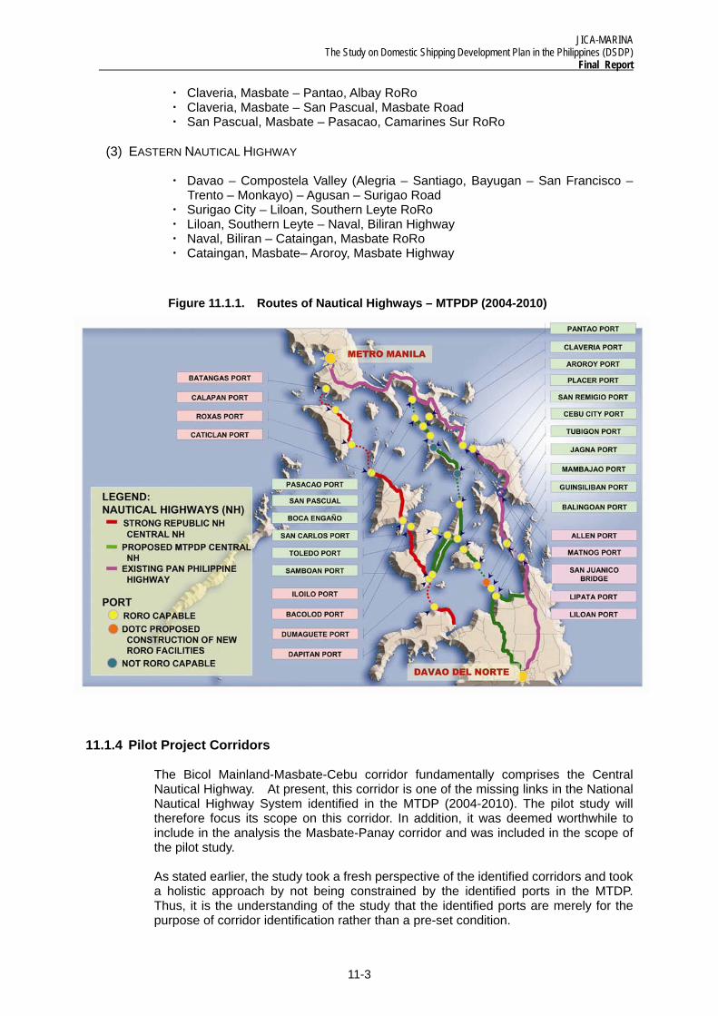
Figure 11.1.1. Routes of Nautical Highways – MTPDP (2004-2010)
11.1.4 Pilot Project Corridors
The Bicol Mainland-Masbate-Cebu corridor fundamentally comprises the Central Nautical Highway. At present, this corridor is one of the missing links in the National Nautical Highway System identified in the MTDP (2004-2010). The pilot study will therefore focus its scope on this corridor. In addition, it was deemed worthwhile to include in the analysis the Masbate-Panay corridor and was included in the scope of the pilot study.
As stated earlier, the study took a fresh perspective of the identified corridors and took a holistic approach by not being constrained by the identified ports in the MTDP. Thus, it is the understanding of the study that the identified ports are merely for the purpose of corridor identification rather than a pre-set condition.
JICA-MARINA The Study on Domestic Shipping Development Plan in the Philippines (DSDP) Final Report
11-4
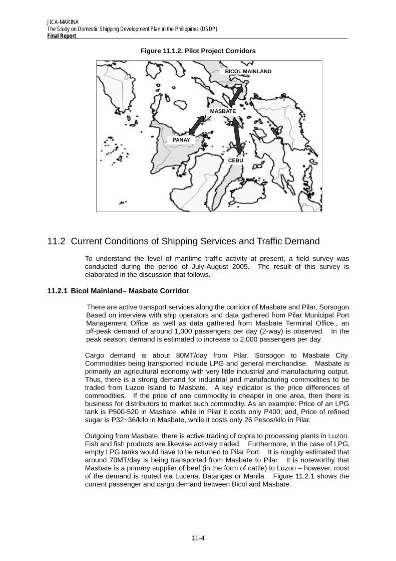
Figure 11.1.2. Pilot Project Corridors
11.2 Current Conditions of Shipping Services and Traffic Demand
To understand the level of maritime traffic activity at present, a field survey was conducted during the period of July-August 2005. The result of this survey is elaborated in the discussion that follows.
11.2.1 Bicol Mainland– Masbate Corridor
There are active transport services along the corridor of Masbate and Pilar, Sorsogon. Based on interview with ship operators and data gathered from Pilar Municipal Port Management Office as well as data gathered from Masbate Terminal Office., an off-peak demand of around 1,000 passengers per day (2-way) is observed. In the peak season, demand is estimated to increase to 2,000 passengers per day.
Cargo demand is about 80MT/day from Pilar, Sorsogon to Masbate City. Commodities being transported include LPG and general merchandise. Masbate is primarily an agricultural economy with very little industrial and manufacturing output. Thus, there is a strong demand for industrial and manufacturing commodities to be traded from Luzon Island to Masbate. A key indicator is the price differences of commodities. If the price of one commodity is cheaper in one area, then there is business for distributors to market such commodity. As an example: Price of an LPG tank is P500-520 in Masbate, while in Pilar it costs only P400; and, Price of refined sugar is P32~36/kilo in Masbate, while it costs only 26 Pesos/kilo in Pilar.
Outgoing from Masbate, there is active trading of copra to processing plants in Luzon. Fish and fish products are likewise actively traded. Furthermore, in the case of LPG, empty LPG tanks would have to be returned to Pilar Port. It is roughly estimated that around 70MT/day is being transported from Masbate to Pilar. It is noteworthy that Masbate is a primary supplier of beef (in the form of cattle) to Luzon – however, most of the demand is routed via Lucena, Batangas or Manila. Figure 11.2.1 shows the current passenger and cargo demand between Bicol and Masbate.
BICOL MAINLAND
MASBATE
PANAY
CEBU
JICA-MARINA The Study on Domestic Shipping Development Plan in the Philippines (DSDP)
Final Report
11-5
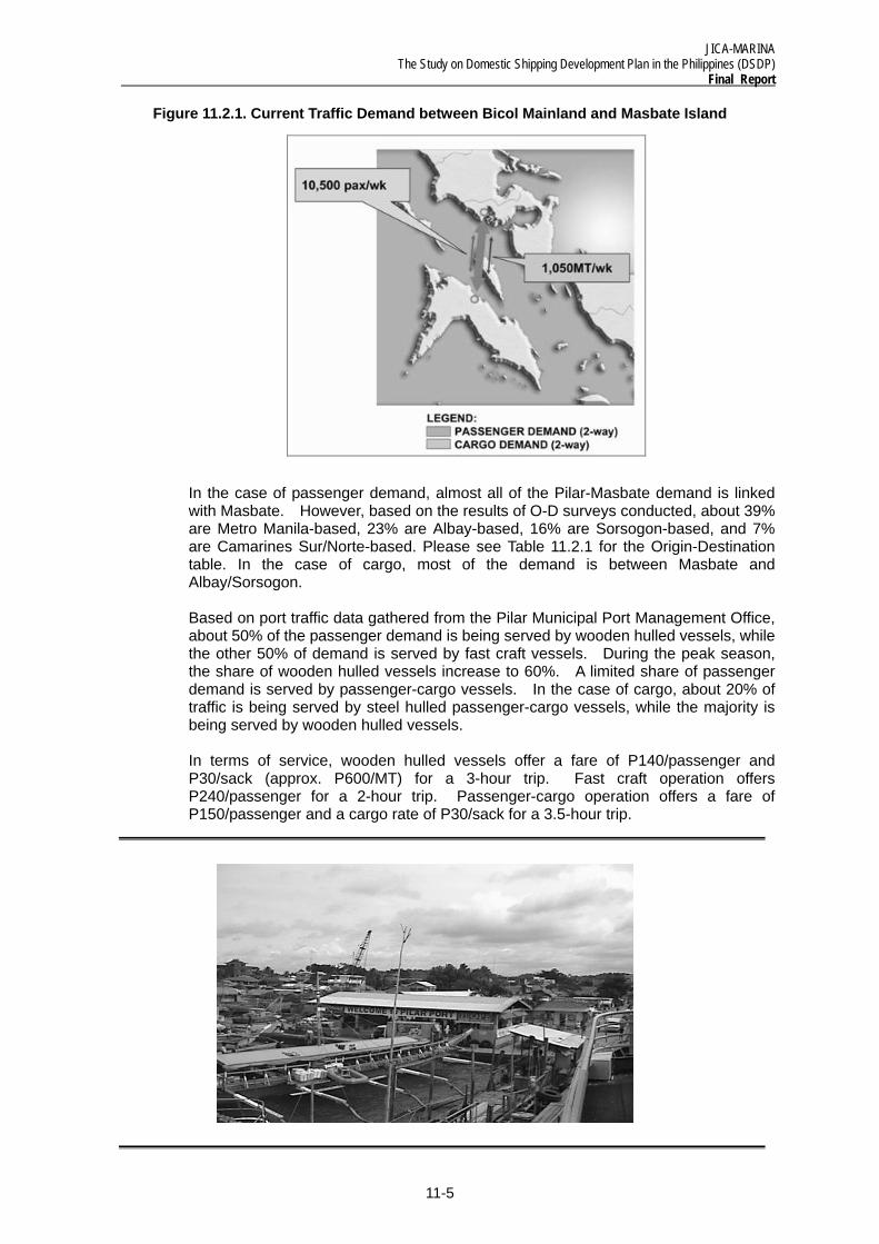
Figure 11.2.1. Current Traffic Demand between Bicol Mainland and Masbate Island
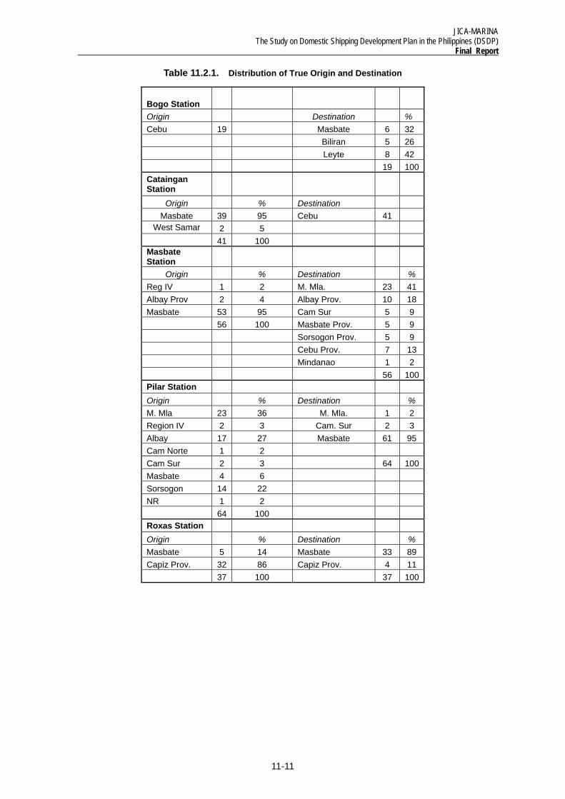
In the case of passenger demand, almost all of the Pilar-Masbate demand is linked with Masbate. However, based on the results of O-D surveys conducted, about 39% are Metro Manila-based, 23% are Albay-based, 16% are Sorsogon-based, and 7% are Camarines Sur/Norte-based. Please see Table 11.2.1 for the Origin-Destination table. In the case of cargo, most of the demand is between Masbate and Albay/Sorsogon.
Based on port traffic data gathered from the Pilar Municipal Port Management Office, about 50% of the passenger demand is being served by wooden hulled vessels, while the other 50% of demand is served by fast craft vessels. During the peak season, the share of wooden hulled vessels increase to 60%. A limited share of passenger demand is served by passenger-cargo vessels. In the case of cargo, about 20% of traffic is being served by steel hulled passenger-cargo vessels, while the majority is being served by wooden hulled vessels.
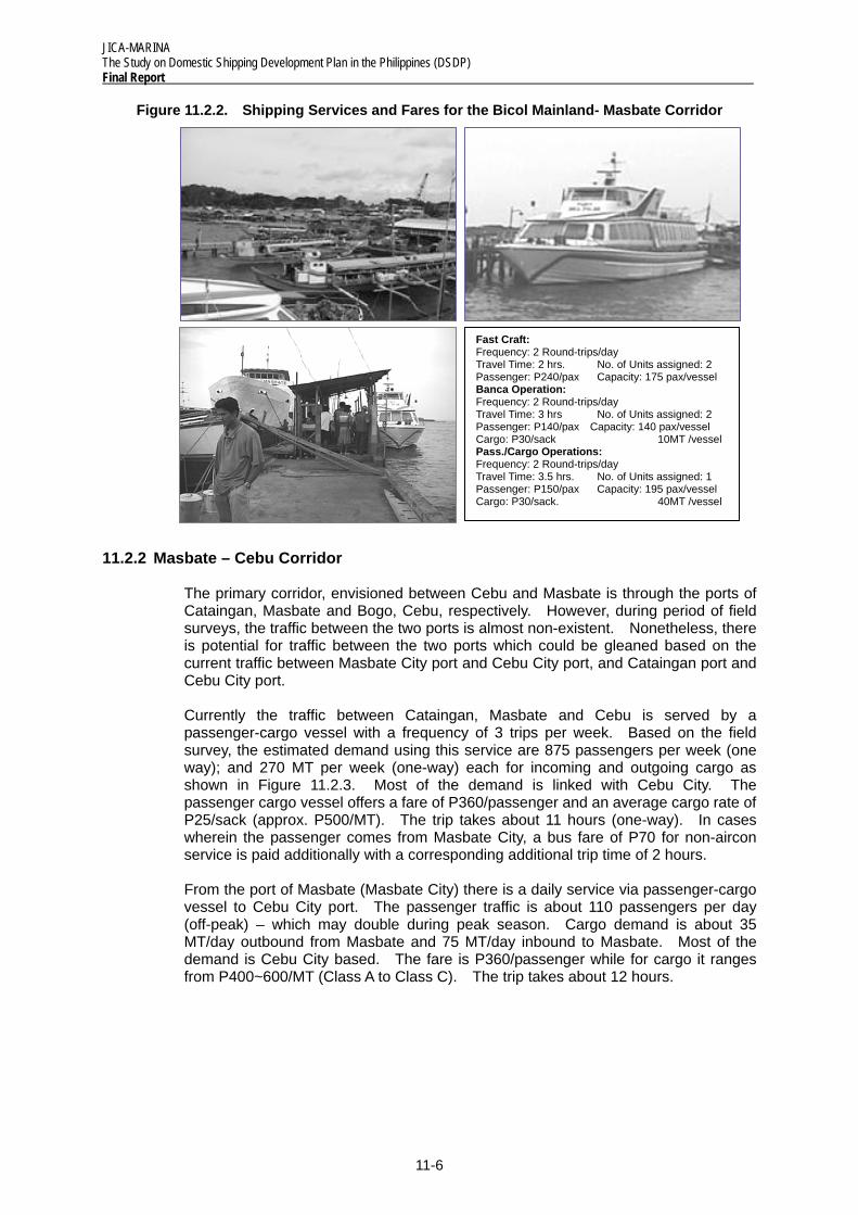
In terms of service, wooden hulled vessels offer a fare of P140/passenger and P30/sack (approx. P600/MT) for a 3-hour trip. Fast craft operation offers P240/passenger for a 2-hour trip. Passenger-cargo operation offers a fare of P150/passenger and a cargo rate of P30/sack for a 3.5-hour trip.
JICA-MARINA The Study on Domestic Shipping Development Plan in the Philippines (DSDP) Final Report
11-6
Figure 11.2.2. Shipping Services and Fares for the Bicol Mainland- Masbate Corridor
11.2.2 Masbate – Cebu Corridor
The primary corridor, envisioned between Cebu and Masbate is through the ports of Cataingan, Masbate and Bogo, Cebu, respectively. However, during period of field surveys, the traffic between the two ports is almost non-existent. Nonetheless, there is potential for traffic between the two ports which could be gleaned based on the current traffic between Masbate City port and Cebu City port, and Cataingan port and Cebu City port.
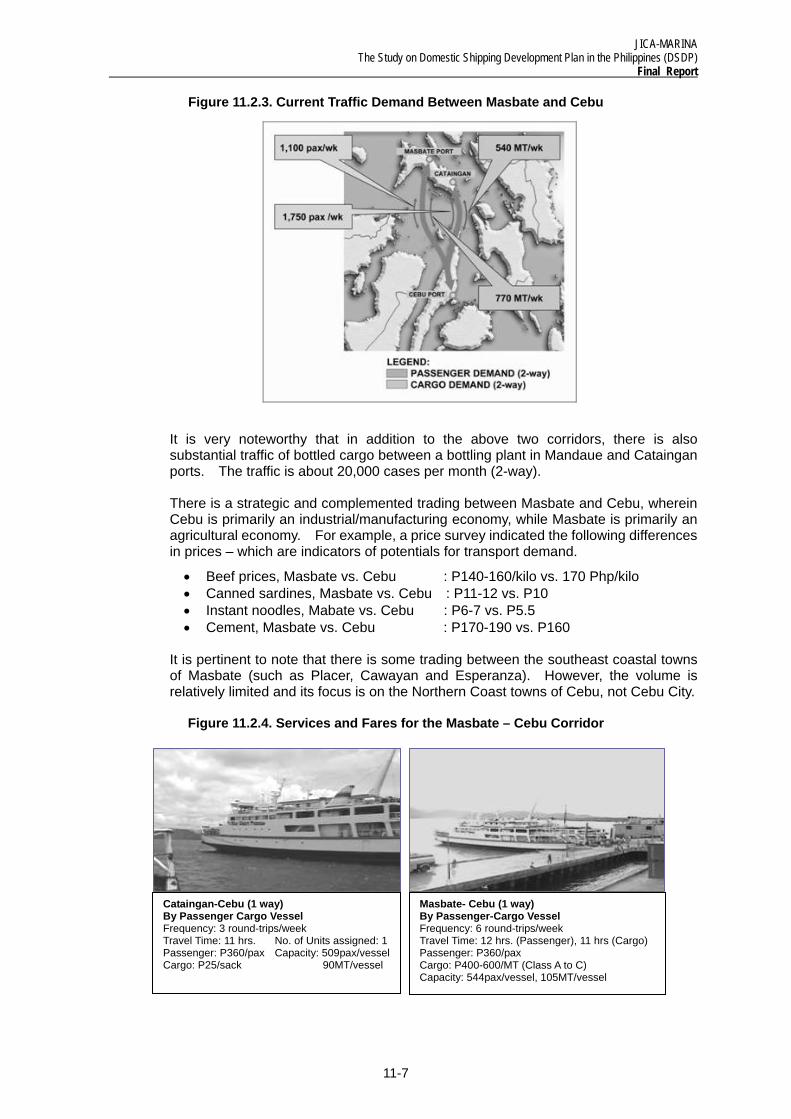
Currently the traffic between Cataingan, Masbate and Cebu is served by a passenger-cargo vessel with a frequency of 3 trips per week. Based on the field survey, the estimated demand using this service are 875 passengers per week (one way); and 270 MT per week (one-way) each for incoming and outgoing cargo as shown in Figure 11.2.3. Most of the demand is linked with Cebu City. The passenger cargo vessel offers a fare of P360/passenger and an average cargo rate of P25/sack (approx. P500/MT). The trip takes about 11 hours (one-way). In cases wherein the passenger comes from Masbate City, a bus fare of P70 for non-aircon service is paid additionally with a corresponding additional trip time of 2 hours.
From the port of Masbate (Masbate City) there is a daily service via passenger-cargo vessel to Cebu City port. The passenger traffic is about 110 passengers per day (off-peak) – which may double during peak season. Cargo demand is about 35 MT/day outbound from Masbate and 75 MT/day inbound to Masbate. Most of the demand is Cebu City based. The fare is P360/passenger while for cargo it ranges from P400~600/MT (Class A to Class C). The trip takes about 12 hours.
Fast Craft:Frequency: 2 Round-trips/day Travel Time: 2 hrs. No. of Units assigned: 2 Passenger: P240/pax Capacity: 175 pax/vessel Banca Operation: Frequency: 2 Round-trips/day Travel Time: 3 hrs No. of Units assigned: 2 Passenger: P140/pax Capacity: 140 pax/vessel Cargo: P30/sack 10MT /vessel Pass./Cargo Operations: Frequency: 2 Round-trips/day Travel Time: 3.5 hrs. No. of Units assigned: 1 Passenger: P150/pax Capacity: 195 pax/vessel Cargo: P30/sack. 40MT /vessel
JICA-MARINA The Study on Domestic Shipping Development Plan in the Philippines (DSDP)
Final Report
11-7
Cataingan-Cebu (1 way) By Passenger Cargo Vessel Frequency: 3 round-trips/week Travel Time: 11 hrs. No. of Units assigned: 1 Passenger: P360/pax Capacity: 509pax/vesselCargo: P25/sack 90MT/vessel
Masbate- Cebu (1 way) By Passenger-Cargo Vessel Frequency: 6 round-trips/week Travel Time: 12 hrs. (Passenger), 11 hrs (Cargo) Passenger: P360/pax Cargo: P400-600/MT (Class A to C) Capacity: 544pax/vessel, 105MT/vessel
Figure 11.2.3. Current Traffic Demand Between Masbate and Cebu
It is very noteworthy that in addition to the above two corridors, there is also substantial traffic of bottled cargo between a bottling plant in Mandaue and Cataingan ports. The traffic is about 20,000 cases per month (2-way).
There is a strategic and complemented trading between Masbate and Cebu, wherein Cebu is primarily an industrial/manufacturing economy, while Masbate is primarily an agricultural economy. For example, a price survey indicated the following differences in prices – which are indicators of potentials for transport demand.
• Beef prices, Masbate vs. Cebu : P140-160/kilo vs. 170 Php/kilo • Canned sardines, Masbate vs. Cebu : P11-12 vs. P10 • Instant noodles, Mabate vs. Cebu : P6-7 vs. P5.5 • Cement, Masbate vs. Cebu : P170-190 vs. P160
It is pertinent to note that there is some trading between the southeast coastal towns of Masbate (such as Placer, Cawayan and Esperanza). However, the volume is relatively limited and its focus is on the Northern Coast towns of Cebu, not Cebu City.
Figure 11.2.4. Services and Fares for the Masbate – Cebu Corridor
JICA-MARINA The Study on Domestic Shipping Development Plan in the Philippines (DSDP) Final Report
11-8
11.2.3 Masbate – Panay Corridor
There are basically three corridors between Masbate and Panay: Balud, Masbate - Roxas City and Balud, Masbate-Estancia, Iloilo and Mandaon, Masbate-Estancia, Iloilo. The Balud take-off point is at the Calumpang port in Barangay Calumpang, Masbate and not at Poblacion port.
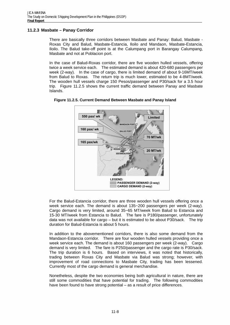
In the case of Balud-Roxas corridor, there are five wooden hulled vessels, offering twice a week service each. The estimated demand is about 420-680 passengers per week (2-way). In the case of cargo, there is limited demand of about 9-16MT/week from Balud to Roxas. The return trip is much lower, estimated to be 4-8MT/week. The wooden hull vessels charge 150 Pesos/passenger and P30/sack for a 3.5 hour trip. Figure 11.2.5 shows the current traffic demand between Panay and Masbate Islands.
Figure 11.2.5. Current Demand Between Masbate and Panay Island
For the Balud-Estancia corridor, there are three wooden hull vessels offering once a week service each. The demand is about 135~200 passengers per week (2-way). Cargo demand is very limited, around 35~65 MT/week from Balud to Estancia and 15-30 MT/week from Estancia to Balud. The fare is P180/passenger, unfortunately data was not available for cargo – but it is estimated to be about P30/sack. The trip duration for Balud-Estancia is about 5 hours.
In addition to the abovementioned corridors, there is also some demand from the Mandaon-Estancia corridor. There are four wooden hulled vessels providing once a week service each. The demand is about 160 passengers per week (2-way). Cargo demand is very limited. The fare is P250/passenger and the cargo rate is P30/sack. The trip duration is 6 hours. Based on interviews, it was noted that historically, trading between Roxas City and Masbate via Balud was strong; however, with improvement of road connections to Masbate City, trading has been lessened. Currently most of the cargo demand is general merchandise.
Nonetheless, despite the two economies being both agricultural in nature, there are still some commodities that have potential for trading. The following commodities have been found to have strong potential – as a result of price differences.
JICA-MARINA The Study on Domestic Shipping Development Plan in the Philippines (DSDP)
Final Report
11-9
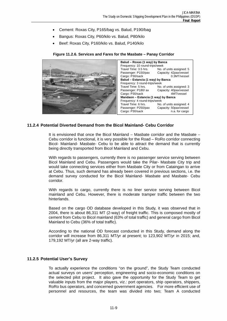
Balud – Roxas (1 way) by Banca Frequency: 10 round-trips/week Travel Time: 3.5 hrs. No. of units assigned: 5 Passenger: P150/pax Capacity: 42pax/vessel Cargo: P30/sack 0.3MT/vessel Balud – Estancia (1 way) by Banca Frequency: 3 round-trips/week Travel Time: 5 hrs. No. of units assigned: 3 Passenger: P180/ ax Capacity: 40pax/vessel Cargo: P30/sack 4MT/vessel Mandaon – Estancia (1 way) by Banca Frequency: 4 round-trips/week Travel Time: 6 hrs. No. of units assigned: 4 Passenger: P250/pax Capacity: 50pax/vessel Cargo: P30/sack n.a. for cargo
• Cement: Roxas City, P165/bag vs. Balud, P190/bag
• Bangus: Roxas City, P60/kilo vs. Balud, P80/kilo
• Beef: Roxas City, P160/kilo vs. Balud, P140/kilo
Figure 11.2.6. Services and Fares for the Masbate – Panay Corridor
11.2.4 Potential Diverted Demand from the Bicol Mainland- Cebu Corridor
It is envisioned that once the Bicol Mainland – Masbate corridor and the Masbate – Cebu corridor is functional, it is very possible for the Road – RoRo corridor connecting Bicol- Mainland- Masbate- Cebu to be able to attract the demand that is currently being directly transported from Bicol Mainland and Cebu.
With regards to passengers, currently there is no passenger service serving between Bicol Mainland and Cebu. Passengers would take the Pilar- Masbate City trip and would take connecting services either from Masbate City or from Cataingan to arrive at Cebu. Thus, such demand has already been covered in previous sections, i.e. the demand survey conducted for the Bicol Mainland- Masbate and Masbate- Cebu corridor.
With regards to cargo, currently there is no liner service serving between Bicol mainland and Cebu. However, there is moderate tramper traffic between the two hinterlands.
Based on the cargo OD database developed in this Study, it was observed that in 2004, there is about 86,311 MT (2-way) of freight traffic. This is composed mostly of cement from Cebu to Bicol mainland (63% of total traffic) and general cargo from Bicol Mainland to Cebu (36% of total traffic).
According to the national OD forecast conducted in this Study, demand along the corridor will increase from 86,311 MT/yr at present; to 123,902 MT/yr in 2015; and, 179,192 MT/yr (all are 2-way traffic).
11.2.5 Potential User’s Survey
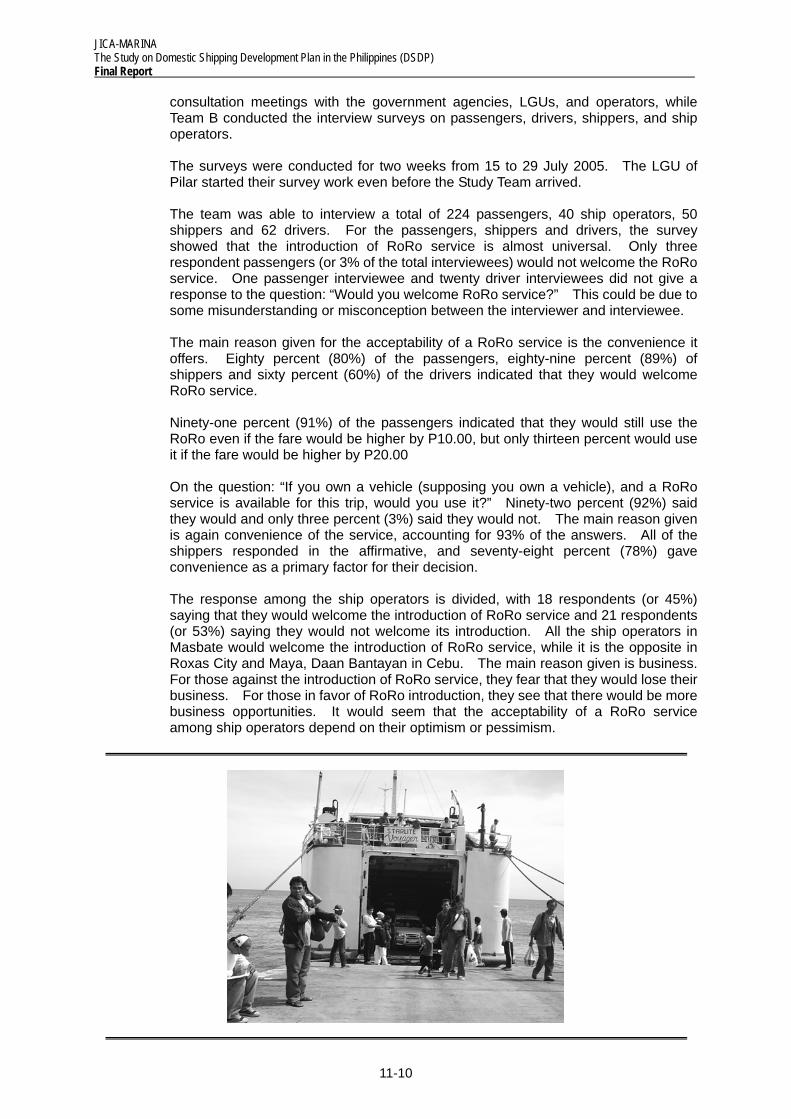
To actually experience the conditions “on the ground”, the Study Team conducted actual surveys on users’ perception, engineering and socio-economic conditions on the selected pilot project. It also gave the opportunity for the Study Team to get valuable inputs from the major players, viz.: port operators, ship operators, shippers, RoRo bus operators, and concerned government agencies. For more efficient use of personnel and resources, the team was divided into two; Team A conducted
JICA-MARINA The Study on Domestic Shipping Development Plan in the Philippines (DSDP) Final Report
11-10
consultation meetings with the government agencies, LGUs, and operators, while Team B conducted the interview surveys on passengers, drivers, shippers, and ship operators.
The surveys were conducted for two weeks from 15 to 29 July 2005. The LGU of Pilar started their survey work even before the Study Team arrived.
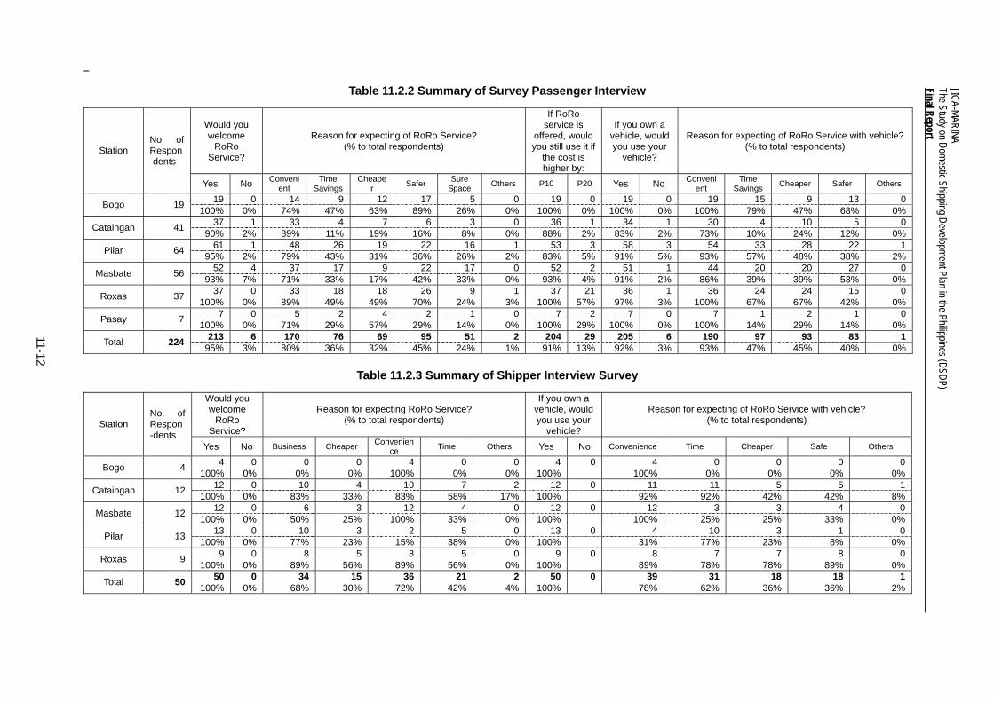
The team was able to interview a total of 224 passengers, 40 ship operators, 50 shippers and 62 drivers. For the passengers, shippers and drivers, the survey showed that the introduction of RoRo service is almost universal. Only three respondent passengers (or 3% of the total interviewees) would not welcome the RoRo service. One passenger interviewee and twenty driver interviewees did not give a response to the question: “Would you welcome RoRo service?” This could be due to some misunderstanding or misconception between the interviewer and interviewee.
The main reason given for the acceptability of a RoRo service is the convenience it offers. Eighty percent (80%) of the passengers, eighty-nine percent (89%) of shippers and sixty percent (60%) of the drivers indicated that they would welcome RoRo service.
Ninety-one percent (91%) of the passengers indicated that they would still use the RoRo even if the fare would be higher by P10.00, but only thirteen percent would use it if the fare would be higher by P20.00
On the question: “If you own a vehicle (supposing you own a vehicle), and a RoRo service is available for this trip, would you use it?” Ninety-two percent (92%) said they would and only three percent (3%) said they would not. The main reason given is again convenience of the service, accounting for 93% of the answers. All of the shippers responded in the affirmative, and seventy-eight percent (78%) gave convenience as a primary factor for their decision.
The response among the ship operators is divided, with 18 respondents (or 45%) saying that they would welcome the introduction of RoRo service and 21 respondents (or 53%) saying they would not welcome its introduction. All the ship operators in Masbate would welcome the introduction of RoRo service, while it is the opposite in Roxas City and Maya, Daan Bantayan in Cebu. The main reason given is business. For those against the introduction of RoRo service, they fear that they would lose their business. For those in favor of RoRo introduction, they see that there would be more business opportunities. It would seem that the acceptability of a RoRo service among ship operators depend on their optimism or pessimism.
JICA-MARINA The Study on Domestic Shipping Development Plan in the Philippines (DSDP)
Final Report
11-11
Table 11.2.1. Distribution of True Origin and Destination
Bogo Station Origin Destination % Cebu 19 Masbate 6 32 Biliran 5 26 Leyte 8 42 19 100 Cataingan Station
Origin % Destination Masbate 39 95 Cebu 41
West Samar 2 5 41 100
Masbate Station
Origin % Destination % Reg IV 1 2 M. Mla. 23 41 Albay Prov 2 4 Albay Prov. 10 18 Masbate 53 95 Cam Sur 5 9 56 100 Masbate Prov. 5 9 Sorsogon Prov. 5 9 Cebu Prov. 7 13 Mindanao 1 2 56 100 Pilar Station Origin % Destination % M. Mla 23 36 M. Mla. 1 2 Region IV 2 3 Cam. Sur 2 3 Albay 17 27 Masbate 61 95 Cam Norte 1 2 Cam Sur 2 3 64 100 Masbate 4 6 Sorsogon 14 22 NR 1 2 64 100 Roxas Station Origin % Destination % Masbate 5 14 Masbate 33 89 Capiz Prov. 32 86 Capiz Prov. 4 11 37 100 37 100
11-12
JICA-MARINA The Study on Domestic Shipping Development Plan in the Philippines (DSDP) Final Report
Table 11.2.2 Summary of Survey Passenger Interview
Would you welcome
RoRo Service?
Reason for expecting of RoRo Service? (% to total respondents)
If RoRo service is
offered, would you still use it if
the cost is higher by:
If you own a vehicle, would you use your
vehicle?
Reason for expecting of RoRo Service with vehicle? (% to total respondents) Station
No. of Respon-dents
Yes No Convenient
Time Savings
Cheaper Safer Sure
Space Others P10 P20 Yes No Convenient
Time Savings Cheaper Safer Others
19 0 14 9 12 17 5 0 19 0 19 0 19 15 9 13 0 Bogo 19 100% 0% 74% 47% 63% 89% 26% 0% 100% 0% 100% 0% 100% 79% 47% 68% 0% 37 1 33 4 7 6 3 0 36 1 34 1 30 4 10 5 0 Cataingan 41 90% 2% 89% 11% 19% 16% 8% 0% 88% 2% 83% 2% 73% 10% 24% 12% 0% 61 1 48 26 19 22 16 1 53 3 58 3 54 33 28 22 1 Pilar 64 95% 2% 79% 43% 31% 36% 26% 2% 83% 5% 91% 5% 93% 57% 48% 38% 2% 52 4 37 17 9 22 17 0 52 2 51 1 44 20 20 27 0 Masbate 56 93% 7% 71% 33% 17% 42% 33% 0% 93% 4% 91% 2% 86% 39% 39% 53% 0% 37 0 33 18 18 26 9 1 37 21 36 1 36 24 24 15 0 Roxas 37 100% 0% 89% 49% 49% 70% 24% 3% 100% 57% 97% 3% 100% 67% 67% 42% 0%
7 0 5 2 4 2 1 0 7 2 7 0 7 1 2 1 0 Pasay 7 100% 0% 71% 29% 57% 29% 14% 0% 100% 29% 100% 0% 100% 14% 29% 14% 0% 213 6 170 76 69 95 51 2 204 29 205 6 190 97 93 83 1 Total 224 95% 3% 80% 36% 32% 45% 24% 1% 91% 13% 92% 3% 93% 47% 45% 40% 0%
Table 11.2.3 Summary of Shipper Interview Survey
Would you welcome
RoRo Service?
Reason for expecting RoRo Service? (% to total respondents)
If you own a vehicle, would you use your
vehicle?
Reason for expecting of RoRo Service with vehicle? (% to total respondents) Station
No. of Respon-dents
Yes No Business Cheaper Convenience Time Others Yes No Convenience Time Cheaper Safe Others
4 0 0 0 4 0 0 4 0 4 0 0 0 0 Bogo 4 100% 0% 0% 0% 100% 0% 0% 100% 100% 0% 0% 0% 0% 12 0 10 4 10 7 2 12 0 11 11 5 5 1 Cataingan 12 100% 0% 83% 33% 83% 58% 17% 100% 92% 92% 42% 42% 8% 12 0 6 3 12 4 0 12 0 12 3 3 4 0 Masbate 12 100% 0% 50% 25% 100% 33% 0% 100% 100% 25% 25% 33% 0% 13 0 10 3 2 5 0 13 0 4 10 3 1 0 Pilar 13 100% 0% 77% 23% 15% 38% 0% 100% 31% 77% 23% 8% 0%
9 0 8 5 8 5 0 9 0 8 7 7 8 0 Roxas 9 100% 0% 89% 56% 89% 56% 0% 100% 89% 78% 78% 89% 0% 50 0 34 15 36 21 2 50 0 39 31 18 18 1 Total 50 100% 0% 68% 30% 72% 42% 4% 100% 78% 62% 36% 36% 2%
JICA-MARINA The Study on Domestic Shipping Development Plan in the Philippines (DSDP)
Final Report
11-13
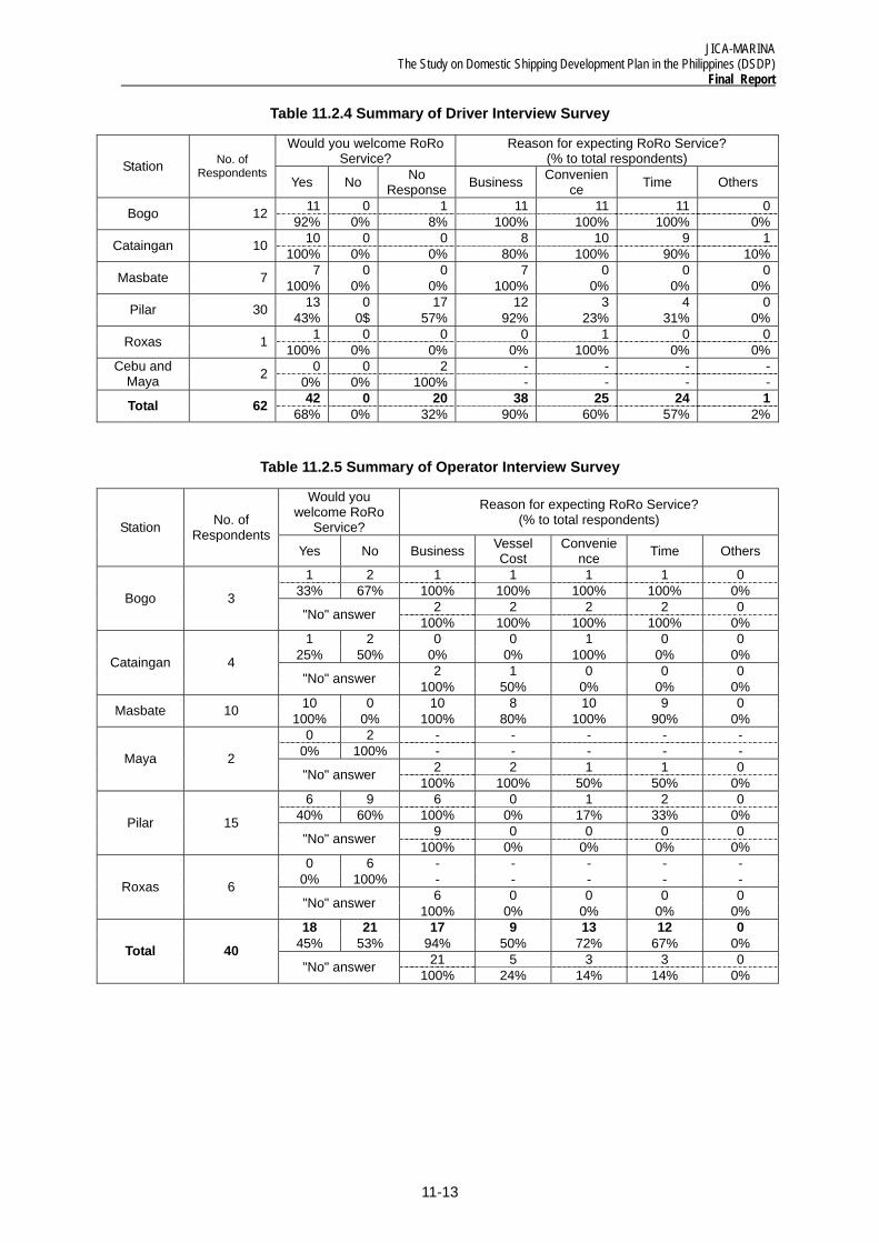
Table 11.2.4 Summary of Driver Interview Survey
Would you welcome RoRo Service?
Reason for expecting RoRo Service? (% to total respondents) Station No. of
RespondentsYes No No
Response Business Convenience Time Others
11 0 1 11 11 11 0Bogo 12 92% 0% 8% 100% 100% 100% 0%10 0 0 8 10 9 1Cataingan 10 100% 0% 0% 80% 100% 90% 10%7 0 0 7 0 0 0Masbate 7 100% 0% 0% 100% 0% 0% 0%
13 0 17 12 3 4 0Pilar 30 43% 0$ 57% 92% 23% 31% 0%1 0 0 0 1 0 0Roxas 1 100% 0% 0% 0% 100% 0% 0%0 0 2 - - - -Cebu and
Maya 2 0% 0% 100% - - - -42 0 20 38 25 24 1Total 62 68% 0% 32% 90% 60% 57% 2%
Table 11.2.5 Summary of Operator Interview Survey
Would you welcome RoRo
Service?
Reason for expecting RoRo Service? (% to total respondents) Station No. of
RespondentsYes No Business Vessel
Cost Convenie
nce Time Others
1 2 1 1 1 1 0 33% 67% 100% 100% 100% 100% 0%
2 2 2 2 0 Bogo 3 "No" answer 100% 100% 100% 100% 0% 1 2 0 0 1 0 0
25% 50% 0% 0% 100% 0% 0% 2 1 0 0 0 Cataingan 4
"No" answer 100% 50% 0% 0% 0% 10 0 10 8 10 9 0 Masbate 10 100% 0% 100% 80% 100% 90% 0% 0 2 - - - - -
0% 100% - - - - - 2 2 1 1 0 Maya 2
"No" answer 100% 100% 50% 50% 0% 6 9 6 0 1 2 0
40% 60% 100% 0% 17% 33% 0% 9 0 0 0 0 Pilar 15
"No" answer 100% 0% 0% 0% 0% 0 6 - - - - -
0% 100% - - - - - 6 0 0 0 0 Roxas 6
"No" answer 100% 0% 0% 0% 0% 18 21 17 9 13 12 0
45% 53% 94% 50% 72% 67% 0% 21 5 3 3 0 Total 40
"No" answer 100% 24% 14% 14% 0%
JICA-MARINA The Study on Domestic Shipping Development Plan in the Philippines (DSDP) Final Report
11-14
11.3 Port Selection
The selection methodology involved two (2) approaches. The first the selection based on comparison of pros and cons of candidate terminals. The second is based on a multi-criteria methodology. Later, it will be shown that both approaches converge on the same conclusion.
11.3.1 Selection Based on Comparison of Pros and Cons
(1) MASBATE-BICOL CORRIDOR
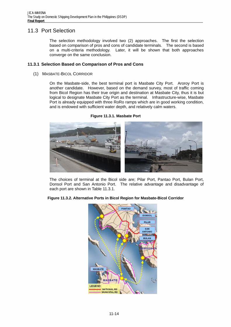
On the Masbate-side, the best terminal port is Masbate City Port. Aroroy Port is another candidate. However, based on the demand survey, most of traffic coming from Bicol Region has their true origin and destination at Masbate City, thus it is but logical to designate Masbate City Port as the terminal. Infrastructure-wise, Masbate Port is already equipped with three RoRo ramps which are in good working condition, and is endowed with sufficient water depth, and relatively calm waters.
Figure 11.3.1. Masbate Port
The choices of terminal at the Bicol side are; Pilar Port, Pantao Port, Bulan Port, Donsol Port and San Antonio Port. The relative advantage and disadvantage of each port are shown in Table 11.3.1.
Figure 11.3.2. Alternative Ports in Bicol Region for Masbate-Bicol Corridor
JICA-MARINA The Study on Domestic Shipping Development Plan in the Philippines (DSDP)
Final Report
11-15
Table 11.3.1. Major Considerations in Port Selection for Masbate Bicol Corridor
MAJOR CONSIDERATION PORT ADVANTAGE DISADVANTAGE REMARKS Pilar • Existing Port well located
with respect to current demand
• Demand has very good access to the Port
• Port depth a bit shallow but workable, sufficient depth 50m from existing port
• Workable- if port is improved
Pantao • Suitable Port Facilities • Not well located with respect to current demand.
• Poor access road condition
• Would not be able to attract demand immediately- risky
Bulan • Suitable Port Facilities • Not well located with respect to current demand
• Would not be able to attract demand immediately- risky
Donsol • Proposed site is a potential tourist destination
• Located in a marine protected area – Habitat of Butanding (whale shark)
• Clear objection from NEDA
San Antonio
• Deeper harbor • No existing port facilities. • Development of approx. 7
km access road from port to national highway is needed.
• Coastline adjacent to proposed Donsol port – similar environmental problem.
• Potentially faces same objection as Donsol
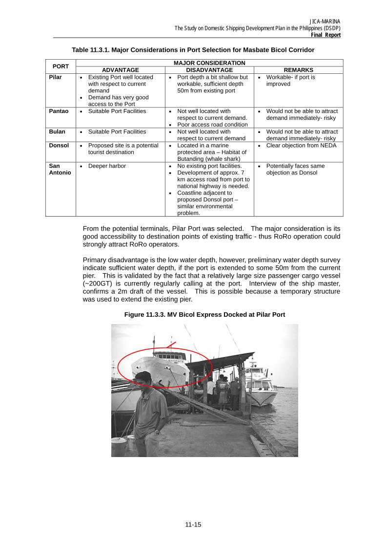
From the potential terminals, Pilar Port was selected. The major consideration is its good accessibility to destination points of existing traffic - thus RoRo operation could strongly attract RoRo operators.
Primary disadvantage is the low water depth, however, preliminary water depth survey indicate sufficient water depth, if the port is extended to some 50m from the current pier. This is validated by the fact that a relatively large size passenger cargo vessel (~200GT) is currently regularly calling at the port. Interview of the ship master, confirms a 2m draft of the vessel. This is possible because a temporary structure was used to extend the existing pier.
Figure 11.3.3. MV Bicol Express Docked at Pilar Port
JICA-MARINA The Study on Domestic Shipping Development Plan in the Philippines (DSDP) Final Report
11-16
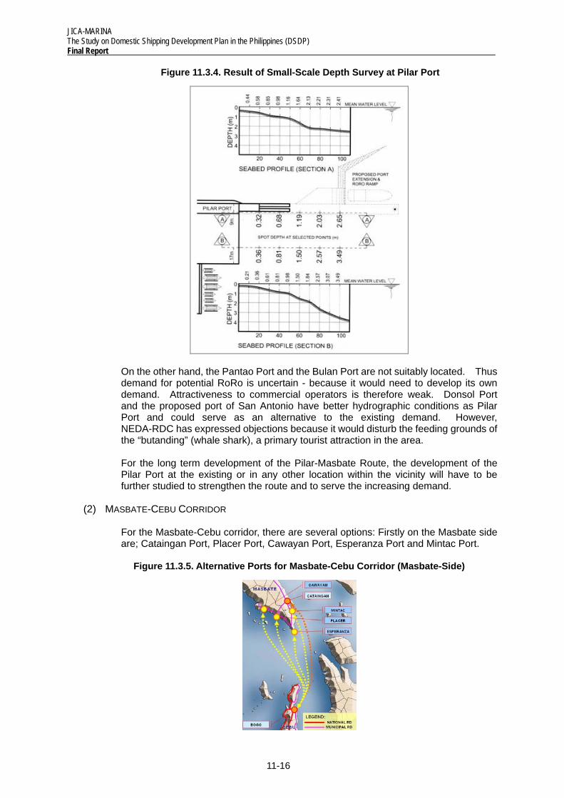
Figure 11.3.4. Result of Small-Scale Depth Survey at Pilar Port
On the other hand, the Pantao Port and the Bulan Port are not suitably located. Thus demand for potential RoRo is uncertain - because it would need to develop its own demand. Attractiveness to commercial operators is therefore weak. Donsol Port and the proposed port of San Antonio have better hydrographic conditions as Pilar Port and could serve as an alternative to the existing demand. However, NEDA-RDC has expressed objections because it would disturb the feeding grounds of the “butanding” (whale shark), a primary tourist attraction in the area.
For the long term development of the Pilar-Masbate Route, the development of the Pilar Port at the existing or in any other location within the vicinity will have to be further studied to strengthen the route and to serve the increasing demand.
(2) MASBATE-CEBU CORRIDOR
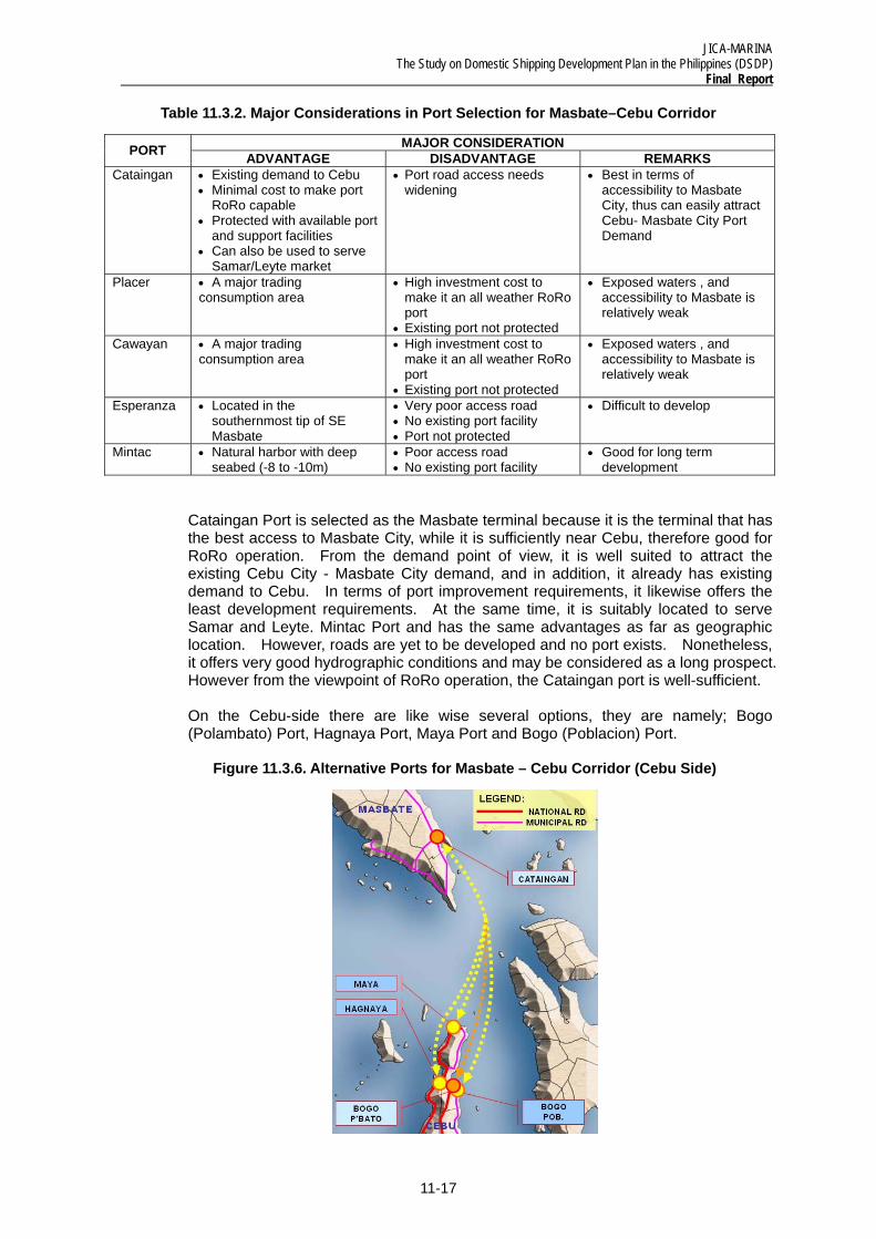
For the Masbate-Cebu corridor, there are several options: Firstly on the Masbate side are; Cataingan Port, Placer Port, Cawayan Port, Esperanza Port and Mintac Port.
Figure 11.3.5. Alternative Ports for Masbate-Cebu Corridor (Masbate-Side)
JICA-MARINA The Study on Domestic Shipping Development Plan in the Philippines (DSDP)
Final Report
11-17
Table 11.3.2. Major Considerations in Port Selection for Masbate–Cebu Corridor
MAJOR CONSIDERATION PORT ADVANTAGE DISADVANTAGE REMARKS Cataingan • Existing demand to Cebu
• Minimal cost to make port RoRo capable
• Protected with available port and support facilities
• Can also be used to serve Samar/Leyte market
• Port road access needs widening
• Best in terms of accessibility to Masbate City, thus can easily attract Cebu- Masbate City Port Demand
Placer • A major trading consumption area
• High investment cost to make it an all weather RoRo port
• Existing port not protected
• Exposed waters , and accessibility to Masbate is relatively weak
Cawayan • A major trading consumption area
• High investment cost to make it an all weather RoRo port
• Existing port not protected
• Exposed waters , and accessibility to Masbate is relatively weak
Esperanza • Located in the southernmost tip of SE Masbate
• Very poor access road • No existing port facility • Port not protected
• Difficult to develop
Mintac • Natural harbor with deep seabed (-8 to -10m)
• Poor access road • No existing port facility
• Good for long term development
Cataingan Port is selected as the Masbate terminal because it is the terminal that has the best access to Masbate City, while it is sufficiently near Cebu, therefore good for RoRo operation. From the demand point of view, it is well suited to attract the existing Cebu City - Masbate City demand, and in addition, it already has existing demand to Cebu. In terms of port improvement requirements, it likewise offers the least development requirements. At the same time, it is suitably located to serve Samar and Leyte. Mintac Port and has the same advantages as far as geographic location. However, roads are yet to be developed and no port exists. Nonetheless, it offers very good hydrographic conditions and may be considered as a long prospect. However from the viewpoint of RoRo operation, the Cataingan port is well-sufficient.
On the Cebu-side there are like wise several options, they are namely; Bogo (Polambato) Port, Hagnaya Port, Maya Port and Bogo (Poblacion) Port.
Figure 11.3.6. Alternative Ports for Masbate – Cebu Corridor (Cebu Side)
JICA-MARINA The Study on Domestic Shipping Development Plan in the Philippines (DSDP) Final Report
11-18
The relative advantage and disadvantage of each are summarized below.
Table 11.3.3. Major Considerations in Port Selection for Cebu-Masbate Corridor
MAJOR CONSIDERATION PORT ADVANTAGE DISADVANTAGE Bogo (Polambato)
• Deep natural harbor • Minimal cost needed • Has sufficient area for future expansion • Good access road • Identified as a major growth center • Also used to serve Leyte Market
• Short macadam access road connecting the port to the National Highway needs to be paved
Hagnaya • Protected and RoRo capable • With available support facilities
• Port busy servicing 3 RoRo vessels to/from Bantayan Island
• Inadequate back-up area/space for future expansion
Maya • Located at the northernmost part of Cebu mainland
• Port site partially protected • Poor access road to Bogo • Not RoRo capable
Bogo (Poblacion)
• Protected and located at the town proper • Good access road to Cebu
• Shallow and very gentle seabed configuration • High investment cost to make port RoRo capable
Demand-wise, all potential ports are along the same corridor thus there is really no distinct advantage of one port over another. However, it should be noted that Maya Port still requires road access improvements. The critical element is therefore investment requirement - which means either Bogo (Polambato) or Hagnaya Port. Bogo (Polambato) requires some improvements, but quite minimal. Hagnaya is operational. However it currently caters to three RoRo vessels going to Bantayan Island and there is not enough space for future expansion. Moreover, Hagnaya has actually a narrow channel which requires dredging. Thus Bogo (Polambato) Port is selected.
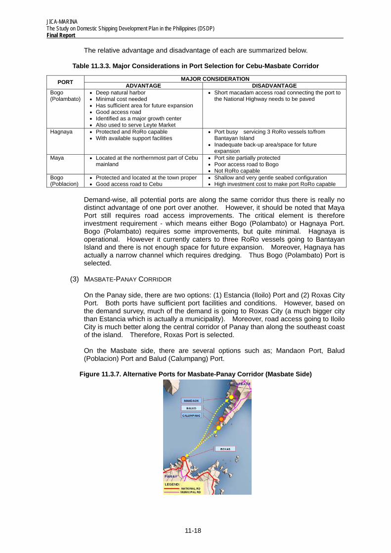
(3) MASBATE-PANAY CORRIDOR
On the Panay side, there are two options: (1) Estancia (Iloilo) Port and (2) Roxas City Port. Both ports have sufficient port facilities and conditions. However, based on the demand survey, much of the demand is going to Roxas City (a much bigger city than Estancia which is actually a municipality). Moreover, road access going to Iloilo City is much better along the central corridor of Panay than along the southeast coast of the island. Therefore, Roxas Port is selected.
On the Masbate side, there are several options such as; Mandaon Port, Balud (Poblacion) Port and Balud (Calumpang) Port.
Figure 11.3.7. Alternative Ports for Masbate-Panay Corridor (Masbate Side)
JICA-MARINA The Study on Domestic Shipping Development Plan in the Philippines (DSDP)
Final Report
11-19
The relative advantages and disadvantages of each candidate port are as follows:
Table 11.3.4. Major Considerations in Port Selection for Masbate-Panay Corridor
MAJOR CONSIDERATION PORT ADVANTAGE DISADVANTAGE Calumpang • Existing demand going to Panay
• Protected by Gintolo and Sapatos Islands• Minimal Cost needed • Present depth is -2.5m but seabed
configuration is sloping; needs minimal dredging to reach design depth of -35.5m
• Poor access road (21 km unpaved road from Balud Poblacion to Calumpang Port and about 20 km unpaved portion between Milagros and Balud, Poblacion going to Masbate City
Balud • Existing demand going to Panay • With existing rock causeway
• Port not protected and shallow • Poor access road (about 20 km unpaved
road between Balud Poblacion and Milagros going to Masbate City)
Mandaon • Relatively better road access • Port with very shallow and gentle seabed configuration extending seawards
• Very limited demand going to Panay exist
All ports are well located to access Masbate City relative to each other, though road conditions are very varied. Balud (Poblacion) port is very shallow and gentle sea bed requires extensive investment for development. Road condition going to Masbate City is very poor with 20 kms of unpaved roads.
Balud (Calumpang) is located further south of Balud (Poblacion) and road conditions are even worse with additional 20 kms of badly maintained dirt roads. However, ports infrastructure are in place with RoRo Ramps under suitable hydrographic conditions.
Mandaon port’s access going to Masbate is along a different road to Balud. Road conditions are relatively better, though roughly 7 kms of road requires paving. There is existing port but would require investment to extend to a suitable depth, which could be considerable because the seabed is gently sloped. Wave condition is quite good because the port is protected.
Under a short-term perspective, the best option is Mandaon Port. This is because of the very bad road conditions going to Balud. However, based on the demand survey, the existing demand is still very weak. Thereby, it is not necessary to adopt a short-term perspective. Road construction is on-going and in the future, the road going to Balud would be improved. Under such conditions, situating the terminal at Balud would be more advantageous, to shorten the sea leg distance.
Comparing the Balud (Poblacion) Port and the Balud (Calumpang) Port, it is deemed better to locate the terminal at the Calumpang Port. This is because it is very difficult to improve the Poblacion Port (shallow, unprotected and gentle seabed) and the Calumpang Port is much nearer to Roxas Port and Estancia Port.
11.3.2 Selection Based on Multi-Criteria Methodology
Table 11.3.5 shows the summary of the multi-criteria method as applied to selection of ports. The point system criteria for the selection of pilot project are shown in the Appendix. Table 11.3.6 shows the result of the application of the abovementioned point system criteria. Table 11.3.7 and Figure 11.3.8 shows the road condition of the proposed RoRo ports to the hinterland. The evaluation of results recommends the prioritization of the following pilot RRTS links for the central (north to south) nautical highway.
JICA-MARINA The Study on Domestic Shipping Development Plan in the Philippines (DSDP) Final Report
11-20
Table 11.3.5. Port Selection Based on Multi-Criteria Method
Multi-Criteria Application of Criteria for the Selection of Pilot Ports 1. Port Hinterland The effect of the port on its hinterland is dependent on how far they are
situated from its other. It is suggested that the principles of the gravity model is applied here. The economic centers would have their equivalent “mass” and the points allocated to the port would be equal to the “mass” divided by the square of the distance, expressed in hours. Another factor considered is the availability of good road connections to the hinterland
2. Development potentials and Relevance to National and Regional Development Plans
The main purpose of the study is to spur regional development and promote national integration. Highest priority is given to the development of national trunk links. Other inter-provincial links are also considered to be important links. Although a proposed RoRo link that connects a detached island with a main island plays a significant role in improving the living conditions of residents in small islands, the magnitude of effects influencing national and regional economy is smaller than those of the national trunk lines.
3. Vehicle Population Vehicle population in the hinterland region of the proposed port site is one factor to assess the potential of the RRTS pilot link. The success of the RoRo Transport System depends on the number of rolling vehicles to move cargoes and passengers between the hinterlands of the route. The same principle of the gravity model is applied. The LTO offices are given an equivalent “mass” depending on the volume of MV registration, and the points given would be the “mass” of MV registration divided by the square of the distance, expressed in time. Please refer to the Appendix for the data on Motor Vehicle Registration in the country and by region.
4. Technical Considerations The topographic and hydrographic conditions in the area should be adequate for the development of the port. There should be adequate depth to accommodate the maximum size vessel otherwise costly underwater excavation or dredging of the harbor basin, anchorage area and access channel would be necessary. The port site must be, as much as possible, not exposed to big waves, strong and swift current as well as big tidal variances.
5. Infrastructure Support Requirements
The existence of port facilities at the proposed RoRo port site would mean lesser development cost and is preferable. The availability of back-up area/space to allow for future expansion, potable water supply, electricity, telecommunication systems and fuel/oil stations will make it more viable for development.
6. LGU Support The support of LGUs are needed in the improvement of access roads leading to the port that are classified as barangay, municipal and provincial roads which are outside the jurisdiction of the Department of Public Works and Highways (DPWH) for development. The support of the LGUs is also necessary in the establishment of a good business environment to make the routes sustainable. Moreover, the LGU could participate actively in the development, management, operation and maintenance of the port.
11-21
JICA-MARINA The Study on Domestic Shipping Development Plan in the Philippines (DSDP)
Final Report
Table 11.3.6. Application of the Criteria for the Selection of Pilot Ports
Port Hinterland (25 pts max.)
Development Potential &Relevance to Natl & Regl.
Devt.
Vehicle Population
Technical Considerations (20 pts max.)
Infrastructure Support Requirements (20 pts max)
Proximity to Maj. Eco. Centers
Road Condi-tions
Formation of RoRo Trunk
line
Future Traffic
Potential
Car Owner-ship in Hinterland
Technical Conditions
Prelim. Cost
Estimate
Existence of Port Facilities
Availability of Utility Sup.
Req'ts
LGU Support (5 pts max.)
Total Points
100 pts max
Rank Name of Port
15 pts max. 10 pts max.
8 pts max.
12 pts max.
10 pts max.
12 pts max.
8 pts max.
12 pts max.
8 pts max
5 pts max
100 pts max
1. Donsol, Sorsogon 6 8 8 12 3 4 2 4 4 5 56 4th
2. Pilar, Sorsogon 12 10 8 12 6 8 4 8 8 5 81 1st
3. Pantao, Albay 3 2 8 12 7 12 8 12 4 5 73 3rd
4. Bulan, Sorsogon 4 10 8 12 5 12 4 10 6 5 76 2nd
5. Cataingan, Masbate 2 10 8 12 0.5 12 8 10 8 5 76 1st
6. Placer, Masbate 1 10 8 12 0.3 4 2 4 6 5 52 2nd
7. Cawayan, Masbate 2 4 8 12 0.8 4 2 4 6 5 48 3rd
8. Bogo, Cebu 5 10 8 12 3 8 8 12 8 5 79 1st
9. Daanbantayan, Cebu 2 4 8 12 1 8 2 4 4 5 50 3rd
10. Hagnaya, S.R., Cebu 4 10 8 12 2 8 8 12 8 5 77 2nd
11. Balud Poblacion, Masbate 2 4 8 12 0.3 4 2 4 6 5 47 2nd
12. Calumpang, Balud,Masbate 2 2 8 12 0.2 8 8 10 6 5 61 1st
13. Roxas, Capiz 3 10 8 12 10 8 8 12 8 5 84 1st
14. Estancia, Iloilo 2 8 8 12 4 2 4 4 8 5 57 2nd
JICA-MARINA The Study on Domestic Shipping Development Plan in the Philippines (DSDP) Final Report
11-22
Table 11.3.7. Road Conditions to Hinterland of the Proposed RoRo Ports
Roadway Type & Condition Area/Route Dist.
km. Travel Time (hr)
Carriage way - Type Condition
Road Classification
BICOL MAINLAND Manila - Naga 415 8.0 two-way Concrete Good National Road Naga- Iriga Proper 38 1.0 two-way Concrete Good National Road Iriga - Legaspi Proper 60 1.5 two-way Concrete Good National Road Legaspi - Sorsogon Proper 56 1.5 two-way Concrete Good National Road Manila-Pilar ( Port), Sorsogon 560 11.0 two way Concrete Good National Road Legaspi City-Pilar Port 47 1.0 two way Concrete Good National Road Pantao Port-Iriga City 52 2.0 two way Concrete (some portions caved-in; bridge w/
loose deteriorated foundation; some road gradient w/ 30% slope)
Fair National Road
Bulan - Sorsogon 59 1.5 two way Concrete Good National Road Donsol - Pilar 15 0.5 two way Concrete Good National Road MASBATE ISLAND Masbate City-Cataingan Port 76.5 2.0 two way Asphalt/Concrete Fair National Road Cataingan-Placer 19 0.50 two way Asphalt Good National Road Placer-Cawayan 18 0.60 two way Asphalt/Gravel Fair National Road Masbate - Uson 30 0.75 two way Asphalt Fair National Road Uson - Cawayan 25 0.83 two way 60% Concrete; 40% Gravel Fair National Road Masbate City-Baleno 15.5 0.50 two way Gravel Bad National Road Baleno- Aroroy 35.1 1.5 two way Gravel:Baleno-Malinta; Paved: Malinta-Aroroy Fair National Road Aroroy-Milagros 42 2.0 two way Gravel Bad National Road Masbate City -Milagros 22 1.0 two way Asphalt/Concrete Good National Road Milagros-Balud(Poblacion) 45.5 1.5 two way Asphalt/Concrete/Gravel(20km) Fair National Road Balud Pob.-Calumpang Port 21 1.0 two way Earth/Gravel Bad National Road Milagros- Mandaon 35 1.5 two way Concrete/Gravel Bad National Road Mandaon-Balud Poblacion 33 1.5 two way Gravel/Concrete Fair National Road PANAY ISLAND Roxas City - Kalibo 75 1.75 two way Concrete Good National Road Roxas City-Iloilo City 136 2.5 two way Concrete Good National Road Roxas City-Estancia Port 61 1.5 two way Concrete Good National Road Estancia Port-Iloilo City 115 2.5 two way 95% Concrete; 5% Gravel Good National Road CEBU ISLAND Cebu-Bogo(Poblacion) 97 2.0 two way Asphalt/Concrete Good National Road Bogo Pob.-Polambato Port 7 10min. two way Gravel Fair National Road Bogo Pob.-San Remigio(Port) 11.5 15min. two way Concrete Good National Road Bogo Pob.-Daanbantayan Pob. 27 40min. two way Concrete/Gravel Fair National Road Daanbantayan Pob.-Maya Port 8.4 20min. two way Gravel (7km); Concrete(1.4km.) Bad National Road Daanbantayan Pob.-Tapilon Port 6 10min. two way Concrete Good National Road
Figure 11.3.8. Linkages on the Pilot RRTS
JICA-MARINA The Study on Domestic Shipping Development Plan in the Philippines (DSDP)
Final Report
11-23
11.3.3 Summary of Selected Ports
As a result, based on the pros and cons analysis and the multi-criteria scoring – the two methodology converge on the same conclusion. This therefore supports a robust selection of optimal terminal for the proposed Central Nautical Highway.
The summary of the selected ports for the following corridors are as follows:
・ Masbate – Bicol Mainland Corridor : Masbate City Port - Pilar Port ・ Masbate – Cebu Corridor : Cataingan Port – Bogo (Polambato) Port ・ Masbate – Panay Corridor : Balud (Polambato) – Roxas Port
11.4 RoRo Port Development Plans and Cost Estimates
11.4.1 Roxas City Port
Roxas City Port is equipped with a RoRo ramp and port condition is suitable for RoRo operation. No further improvement is required.
Figure 11.4.1. Photos of Roxas Port Showing Its Current State
Figure 11.4.2. Development Plan of Roxas Port
JICA-MARINA The Study on Domestic Shipping Development Plan in the Philippines (DSDP) Final Report
11-24
11.4.2 Masbate City Port
Masbate City Port has suitable port conditions and facilities for RoRo operation. No further improvement is required.
Figure 11.4.3. Photos of Masbate City Port
Figure 11.4.4. Development Plan of Masbate City Port
11.4.3 Pilar, Sorsogon Port
Pilar Port – was constructed by DPWH in late 1970s. It was established and expanded by PFDA in 1990. LGU-Pilar provided funds for the reclamation of bus terminal, construction of LGU port office and ticketing office while LGU-Province provided funds for the rehabilitation of the passenger terminal building. The port is being operated and managed by LGU-Pilar.
At present, the existing port conditions and requirements are shown in Table 11.4.1, Figure 11.4.5 and 11.4.6. Based on the identified problems and issues of Pilar Port, the following Development Plan for Pilar is proposed as illustrated in Figure 11.4.7.
JICA-MARINA The Study on Domestic Shipping Development Plan in the Philippines (DSDP)
Final Report
11-25
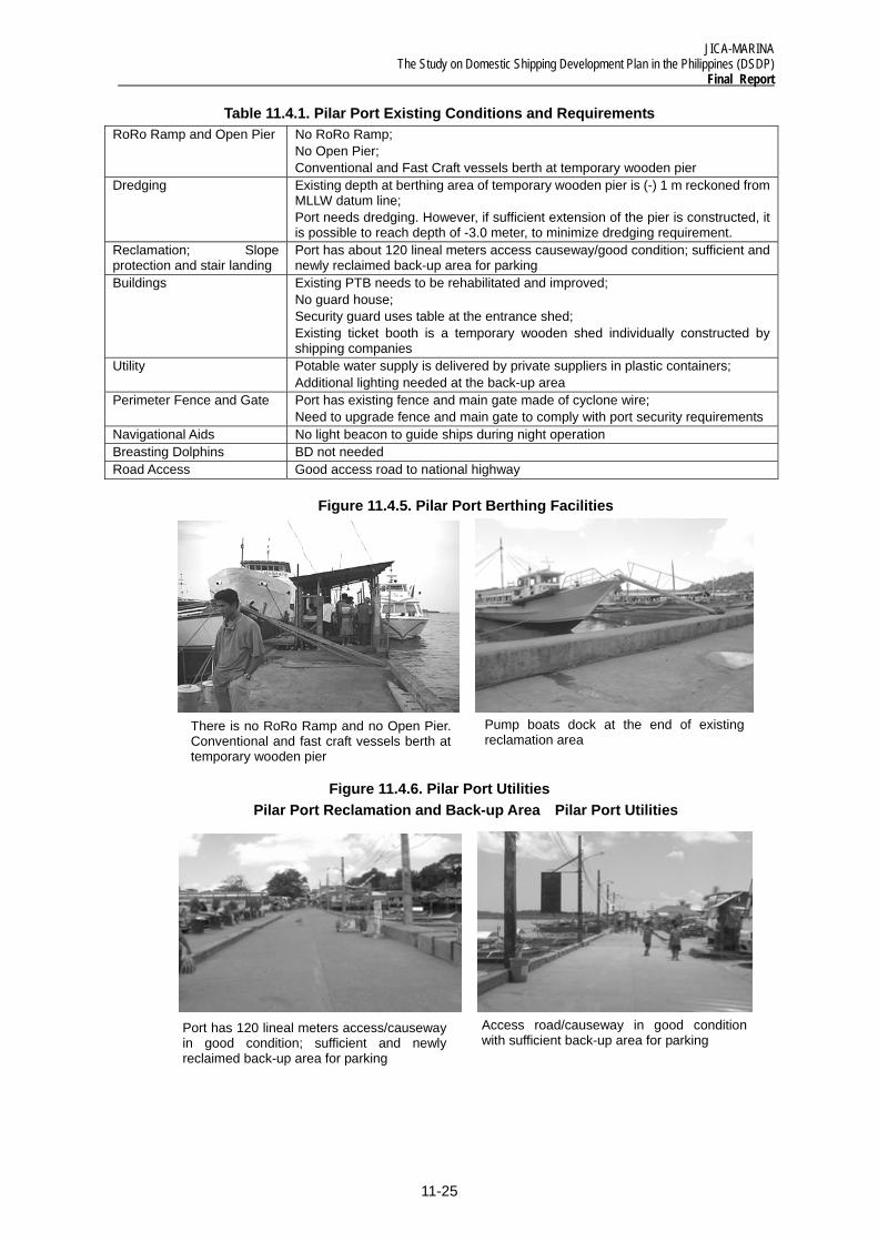
Table 11.4.1. Pilar Port Existing Conditions and Requirements RoRo Ramp and Open Pier No RoRo Ramp;
No Open Pier; Conventional and Fast Craft vessels berth at temporary wooden pier
Dredging Existing depth at berthing area of temporary wooden pier is (-) 1 m reckoned from MLLW datum line; Port needs dredging. However, if sufficient extension of the pier is constructed, it is possible to reach depth of -3.0 meter, to minimize dredging requirement.
Reclamation; Slope protection and stair landing
Port has about 120 lineal meters access causeway/good condition; sufficient and newly reclaimed back-up area for parking
Buildings Existing PTB needs to be rehabilitated and improved; No guard house; Security guard uses table at the entrance shed; Existing ticket booth is a temporary wooden shed individually constructed by shipping companies
Utility Potable water supply is delivered by private suppliers in plastic containers; Additional lighting needed at the back-up area
Perimeter Fence and Gate Port has existing fence and main gate made of cyclone wire; Need to upgrade fence and main gate to comply with port security requirements
Navigational Aids No light beacon to guide ships during night operation Breasting Dolphins BD not needed Road Access Good access road to national highway
Figure 11.4.5. Pilar Port Berthing Facilities
Figure 11.4.6. Pilar Port Utilities
Pilar Port Reclamation and Back-up Area Pilar Port Utilities
There is no RoRo Ramp and no Open Pier. Conventional and fast craft vessels berth at temporary wooden pier
Pump boats dock at the end of existing reclamation area
Port has 120 lineal meters access/causeway in good condition; sufficient and newly reclaimed back-up area for parking
Access road/causeway in good condition with sufficient back-up area for parking
JICA-MARINA The Study on Domestic Shipping Development Plan in the Philippines (DSDP) Final Report
11-26
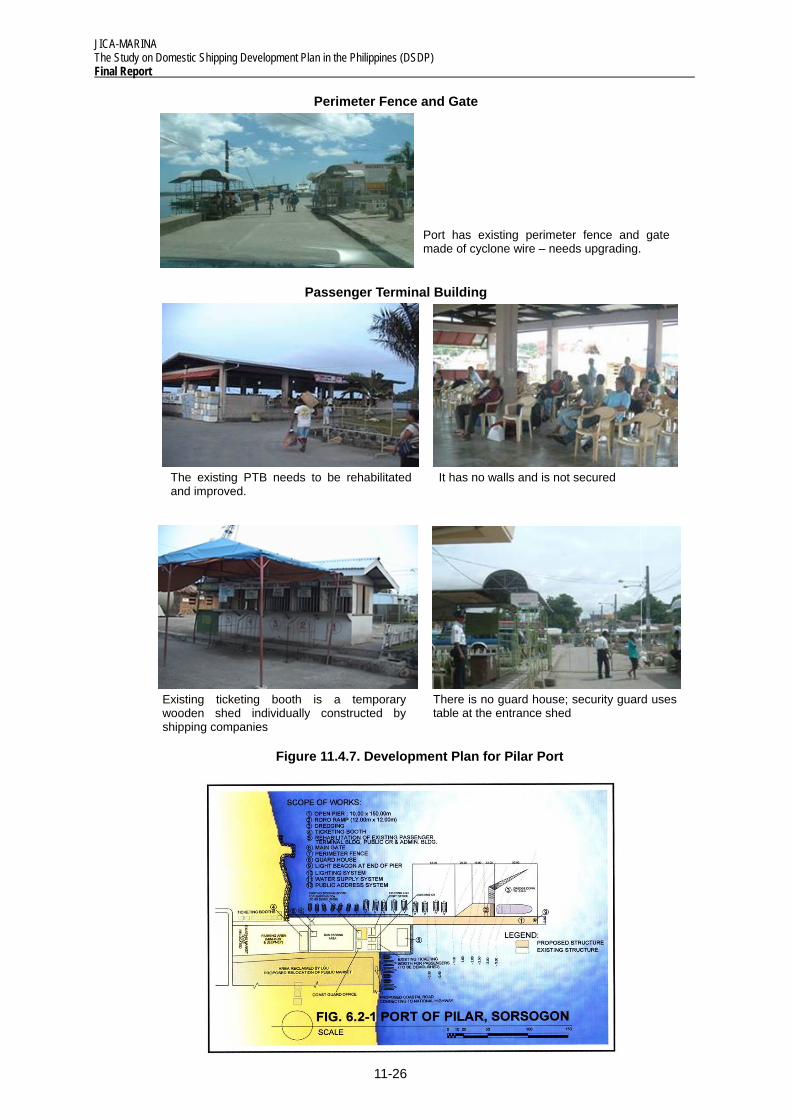
Perimeter Fence and Gate
Passenger Terminal Building
Figure 11.4.7. Development Plan for Pilar Port
There is no guard house; security guard uses table at the entrance shed
The existing PTB needs to be rehabilitated and improved.
It has no walls and is not secured
Port has existing perimeter fence and gate made of cyclone wire – needs upgrading.
Existing ticketing booth is a temporary wooden shed individually constructed by shipping companies
JICA-MARINA The Study on Domestic Shipping Development Plan in the Philippines (DSDP)
Final Report
11-27
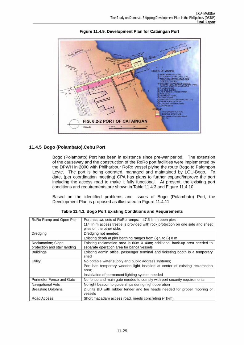
11.4.4 Cataingan, Masbate Port
Cataingan Port – was constructed by the DPWH in the 1980s. It was rehabilitated and expanded by the DOTC in 2002. After the completion of the port in 2003, the facilities were turned over to LGU directly by DOTC for operation, management and maintenance. To date, (per coordination meeting) the LGU has plans to further expand the port utilizing DBP funds in order to be able to accommodate RoRo vessels and bigger conventional vessels. At present, the existing port conditions and requirements are shown in Table 11.4.2 and Figure 11.4.8.
Based on the identified problems and issues of the Port, the Development Plan is proposed as illustrated in Figure 11.4.9.
Table 11.4.2. Cataingan Port Existing Conditions and Requirements
RoRo Ramp and Open Pier
No RoRo Ramp; Existing open pier is 11m X 50m long and needs extension of 20m to accommodate conventional or RoRo vessels
Dredging Dredging not needed; Existing depth at pier berthing ranges from (-) 3 to (-)3.5m from MLLW
Reclamation; Slope protection and stair landing
Existing reclamation area is 53m X 40m or 2,120 sqm used by pax/cargoes from both banca vessels and conventional vessels; Port needs additional back-up area for staging area and for parking and banca users
Buildings Port has existing multi-purpose shed which serves as admin office and passenger terminal, 5m X 20m; No guard house
Utility No potable water supply and public address systems; Port has existing lighting facilities but additional lighting needed at back-up areas, pier extension and RoRo Facilities
Perimeter Fence and Gate
No fence and main gate needed to comply with port security requirements
Navigational Aids Port has existing light beacon at the end of the reclamation area
Breasting Dolphins BD not needed Road Access Good access road to Masbate City
JICA-MARINA The Study on Domestic Shipping Development Plan in the Philippines (DSDP) Final Report
11-28
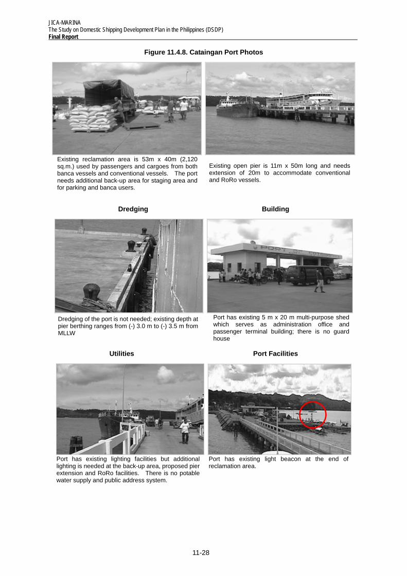
Figure 11.4.8. Cataingan Port Photos
Dredging Building
Utilities Port Facilities
Existing reclamation area is 53m x 40m (2,120 sq.m.) used by passengers and cargoes from both banca vessels and conventional vessels. The port needs additional back-up area for staging area and for parking and banca users.
Existing open pier is 11m x 50m long and needs extension of 20m to accommodate conventional and RoRo vessels.
Dredging of the port is not needed; existing depth at pier berthing ranges from (-) 3.0 m to (-) 3.5 m from MLLW
Port has existing 5 m x 20 m multi-purpose shed which serves as administration office and passenger terminal building; there is no guard house
Port has existing light beacon at the end of reclamation area.
Port has existing lighting facilities but additional lighting is needed at the back-up area, proposed pier extension and RoRo facilities. There is no potable water supply and public address system.
JICA-MARINA The Study on Domestic Shipping Development Plan in the Philippines (DSDP)
Final Report
11-29
Figure 11.4.9. Development Plan for Cataingan Port
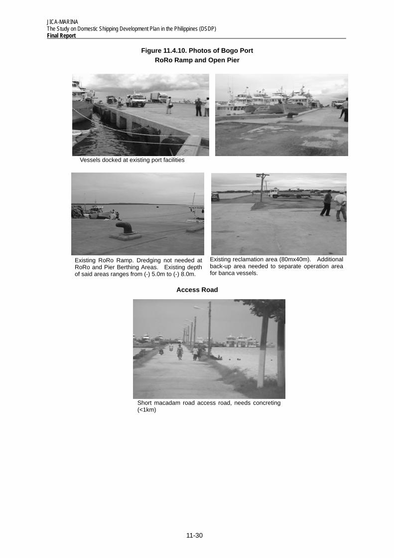
11.4.5 Bogo (Polambato),Cebu Port
Bogo (Polambato) Port has been in existence since pre-war period. The extension of the causeway and the construction of the RoRo port facilities were implemented by the DPWH in 2000 with Philharbour RoRo vessel plying the route Bogo to Palompon Leyte. The port is being operated, managed and maintained by LGU-Bogo. To date, (per coordination meeting) CPA has plans to further expand/improve the port including the access road to make it fully functional. At present, the existing port conditions and requirements are shown in Table 11.4.3 and Figure 11.4.10.
Based on the identified problems and issues of Bogo (Polambato) Port, the Development Plan is proposed as illustrated in Figure 11.4.11.
Table 11.4.3. Bogo Port Existing Conditions and Requirements
RoRo Ramp and Open Pier Port has two sets of RoRo ramps; 47.5 lin m open pier; 114 lin m access trestle is provided with rock protection on one side and sheet piles on the other side.
Dredging Dredging not needed; Existing depth at pier berthing ranges from (-) 5 to (-) 8 m
Reclamation; Slope protection and stair landing
Existing reclamation area is 80m X 40m; additional back-up area needed to separate operation area for banca vessels
Buildings Existing admin office, passenger terminal and ticketing booth is a temporary shed
Utility No potable water supply and public address systems; Port has temporary wooden light installed at center of existing reclamation area; Installation of permanent lighting system needed
Perimeter Fence and Gate No fence and main gate needed to comply with port security requirements Navigational Aids No light beacon to guide ships during night operation Breasting Dolphins 2 units BD with rubber fender and tee heads needed for proper mooring of
vessels Road Access Short macadam access road, needs concreting (<1km)
JICA-MARINA The Study on Domestic Shipping Development Plan in the Philippines (DSDP) Final Report
11-30
Figure 11.4.10. Photos of Bogo Port RoRo Ramp and Open Pier
Access Road
Existing reclamation area (80mx40m). Additional back-up area needed to separate operation area for banca vessels.
Vessels docked at existing port facilities
Existing RoRo Ramp. Dredging not needed at RoRo and Pier Berthing Areas. Existing depth of said areas ranges from (-) 5.0m to (-) 8.0m.
Short macadam road access road, needs concreting (<1km)


![Deltamarin Roro References[1]](https://img.pdfslide.us/doc/110x75/577cda651a28ab9e78a58f5c/deltamarin-roro-references1.jpg)