Embed Size (px)
Citation preview

Putting the Pacific Islands
on the National Map
Overview of Coastal Change Analysis Program (C-CAP)
Christine FeinholzNOAA Pacific Services Center

The Coastal Change Analysis Program
• National coastal land cover and change mapping program
• Inventory of intertidal areas, wetlands, and adjacent upland, produced/updated every 5 years
• Consistent, accurate products through standard data and methods
• Coastal Expression of the National Land Cover Database (NLCD)
“Designed to help improve understanding of linkages
between land change and the environment”

1996, 2001 BaselineMapping Complete
We’ve got the CONUS Covered
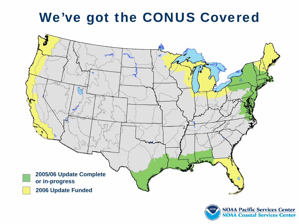
2006 Update Funded
2005/06 Update Completeor in-progress
We’ve got the CONUS Covered

…and Hawai`i Land Cover
Land Cover
20012005 In
Progress1992 In Progress

…and Hawai`i and Guam Impervious Surfaces
Impervious Surfaces
2001 2005In Progress
Impervious Surfaces – 75% Coverage
2005In Progress

WaterOpen Water Palustrine Aquatic BedEstuarine Aquatic Bed
Wetlands Woody Wetlands
Palustrine Forested WetlandPalustrine Scrub/Shrub WetlandEstuarine Forested WetlandEstuarine Scrub/Shrub Wetland
Herbaceous WetlandsPalustrine Emergent Wetland Estuarine Emergent Wetland
DevelopedDeveloped, High Intensity Developed, Medium IntensityDeveloped, Low Intensity Developed, Open Space
AgriculturalCultivated Crops Pasture/Hay
RangelandGrassland/Herbaceous Scrub / Shrub
Forest LandDeciduous Forest Evergreen Forest Mixed Forest
Barren LandBarren Land Unconsolidated Shore
C-CAP Classification Scheme
NLCD
NLCD
C-CAP Hawai`i only
C-CAP Hawai`i only
Not Hawai`i
Not Hawai`i

• Hawaiian islands will be part of the 2001 National Land Cover Database (NLCD) effort
– NOAA and USGS cooperative effort
• Derived from 30 meter Landsat multispectral imagery
• A “re-release” of existing land cover information for the islands
– C-CAP and HI GAP (2001)– We are not remapping the islands– This is not an updated land cover
• 2005 products being produced based on high res production
Moderate Resolution Land Cover
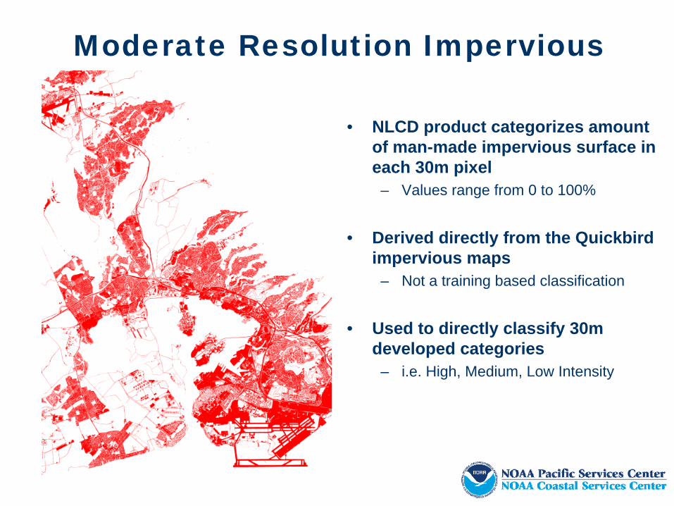
Moderate Resolution Impervious
• NLCD product categorizes amount of man-made impervious surface in each 30m pixel
– Values range from 0 to 100%
• Derived directly from the Quickbird impervious maps
– Not a training based classification
• Used to directly classify 30m developed categories
– i.e. High, Medium, Low Intensity

High Resolution Impervious
• Derived from 2.4 meter Quickbird multispectral imagery (2005)
• Provide detailed information on location and extent of man-made impervious surfaces
• Developed in partnership with State of Hawaii Office of Planning
• Available now for 7 of the main 8 islands of Hawaii and Guam
– Island of Hawaii available shortly– Hawaii is 75% complete due to clouds

High Resolution Land Cover
• Derived from 2.4 meter Quickbird multispectral imagery (2005)
• More detailed and up-to-date than previously available land cover information
• Island of Oahu Available now– AA to be complete Summer 2008
• Islands of Maui, Molokai, Lanai, and Kahoolawe in-progress
– Will be released as completed– Anticipated to be complete by
December of 2008

Land Cover Tools N-SPECT
- Non-point Source Pollution and Erosion Comparison Tool
- Downloadable GIS extension
- Inputs: Land Cover, Elevation, Precipitation, Soil Characteristics,
- Predicts surface water runoff, nonpoint source pollution, and erosion.
- Land Cover Change Scenarioshttp://www.csc.noaa.gov/crs/cwq/nspect.html

Land Cover Tools HPP
- Habitat Priority Planner
- Downloadable GIS extension
- Inputs: Land Cover, project specific points, lines, or polygons
- Inventory habitat conditions
- Identify, rank, and prioritize conservation sites
- Analyze proposed changes in land use or land cover
http://www.csc.noaa.gov/hpp/

Land Cover Tools Digital Coast Land Cover Atlas
- Online Land Cover Summary and Analysis Website
- Summarizes Land Cover for user defined areas
- Will not require GIS software
- Publicly Available

Data Availability
Island Land Cover Impervious Land Cover Impervious Land Cover Impervious Land Cover Impervious
Kaua`i and Ni`ihau Summer 2008 Summer 2008 Fall 2008 Fall 2008
O`ahu Summer 2008 Summer 2008 Fall 2008 Fall 2008
Maui December 2008 December 2008 Summer 2008 Summer 2008
Moloka`i February 2009 February 2009 Summer 2008 Summer 2008
Lana`i February 2009 February 2009 Summer 2008 Summer 2008
Kaho`olawe February 2009 February 2009 Summer 2008 Summer 2008
Hawai`i Island Summer 2008 Summer 2008 Summer 2008
Guam Summer 2008
2005 High Resolution 2005 Moderate Resolution 2001 Moderate Resolution 1992 Moderate Resolution

www.csc.noaa.gov/landcover
For More Information
Land Cover
www.csc.noaa.gov/nspectN-SPECT
HPP www.csc.noaa.gov/hpp
Email:[email protected]

www.csc.noaa.gov/landcover
For More Information:
Land Cover
www.csc.noaa.gov/nspectN-SPECT
HPP www.csc.noaa.gov/hpp
NOAA Coastal Services Center2234 South Hobson Avenue
Charleston, South Carolina 29405(843) 740-1200
www.csc.noaa.gov
NOAA Pacific Services Center737 Bishop St., Suite 1550
Honolulu, Hawaii 96813 (808) 532-3200
www.csc.noaa.gov/psc/