Embed Size (px)
Citation preview

GEO Laboratory
Overview of Free and Open Source Software for Geoinformation (FOSS4G)
Politecnico di Milano, DICA – GEO Laboratory
Maria Antonia Brovelli

2
Short intro: GEO Lab @ PoliMI
http://geolab.como.polimi.it/
Research fields● GIS● Global Gravity Models● GNSS● SAR
GIS Magic Team: collaborative work

3
Topics
● WebMapping (virtual globes, multiframe,etc)● Global Land Coverage ● Open Data Quality● Migration from proprietary to OS Solutions● Citizen Science and Geocrowdsourcing
Geo for All
UN OPENGIS

4
UN OpenGIS
The Geospatial Information Section (UNGIS) and Information and Communications Technology Division (ICTD) of the United Nations Department of Field Support (DFS) gave birth to the UN OpenGIS Experiment
Capacity Buildingwith G4A

5
Geoinformatics Engineering MSc at PoliMI
The Master of Science in Geoinformatics Engineering is a two years international master course taught in English for Italian and foreign students.Students with academic background in environmental science will find an introductory course in computer science, while those with a computer oriented first level degree will follow a basic course on geomatics and environmental issues.The mandatory courses cover topics such as Geospatial Data Analysis, Geographical Information Systems (GIS), Positioning and location based services, Pollution measurement and management on the Geomatics / Environmental side as well as Databases, Software engineering, Computer Infrastructures, Formal languages in the Computer Science area.Eligible courses will allow students to deepen their expertise either in computer programming and computer systems design or in geomatics and environmental issues .
http://www.geoinformatics.polimi.it/

6
Overview
● The context: Future Earth and Digital Earth
● FOSS4G/OSGeo/GeoForAll
● Applications

7
The Future Earth
✔ Future Earth (FE) is a 10-year international research initiative that emerged in 2011 to create a global environmental change research platform to provide more useful and accessible knowledge for decision-makers, and to support the acceleration of the transformation to a sustainable world (Future Earth Norway Secretariat 2015; Future Earth Secretariat 2013).
✔ FE focuses on three main research themes: – Dynamic Planet; – Global Sustainable Development; – Transformations Towards Sustainability (Future Earth
Secretariat 2014).

8
The Future Earth
✔ It is designed to provide a fundamental, holistic understanding of the interconnections between natural and human drivers of change, the resulting environmental changes, and their implications for human well-being (Future Earth Secretariat 2013).
✔ While FE is conceived as a global research platform for co-creating and co-developing knowledge, Digital Earth is the technological framework and infrastructure to realize the FE vision and goals.

9
✔ The Digital Earth (DE) was introduced in 1998 by Al Gore, as a tri-dimensional and multi-resolution model of the planet which make it possible to visually put in place the huge amount of geo-referenced information about the physical and social environment.
✔ This system allows the user to navigate not only in space but also in time, by having access to historical data sets and to future prevision based on social and environmental models.
✔ Gore, A., 1998 The Digital Earth: underdstanding our planet in the 21st century,
✔ http://portal.opengeospatial.org/files/?artifact_id=6210.
The Digital Earth

10
✔ There isn't a single Digital Earth.
✔ The Digital Earth is a mix of shared, multi-thematic,
multi-resolution and multi-perspective archives of geo-referenced knowledge, which meet the requirements of different parties, like scientist, decision makers, cummunity and citizens.
✔ All these archives, which are updated in real-time thanks to sensor observations and information, are interconnected.
✔ The Digital Earth is based on open access and on the users participation through multiple technological platforms.
The Digital Earth

11
✔ Every day we create 2.5 trillion (1018) bytes of data. 80 % of these are already georeferenced or can be.
✔ It's a huge dataset, equal to a DVD tower that goes from the Earth to the Moon every day.
Citizens as Passive or activesensors
Geo Big Data

12
✔ By 2020 there will be 26 billions of connected devices.
✔ The Internet of things is a possible evolution of the use of the Internet.
✔ The objects become recognisable thanks to the ability to communicate data about themselves and to access information provided by others.
Internet of Things (IoT)

13
Users
Catalogues
Data/Objects
Processing
Geospatial Web
Internet

14
Web Service“... a software system designed to support the
interoperability between network machines ”
NETWORK
NETWORK
Web Geospatial Service“...specific web services for geospatial data and
information”
Web Geospatial Services

15
CataloguesData
RASTER DATA
●
GRID DATA
VECTOR DATA
Other geospatial data(e.g. sensors)
Processing
INPUT data
● PROCESSED DATA
Geo Services Types

16
Data
INTERNET
● COVERAGE DATA
● VECTOR DATA
● RASTER DATA
Geodata Services

17
Server Client
INTERNET
DIGITAL TERRAIN MODEL
BASIC MAP
THEMATIC MAP
Cartographic Mashup

18
INTERNET
CATALOGUE A
CATALOGUE B
CATALOGUE C(Metadata)
CATALOGUE A CATALOGUE B CATALOGUE C
Geo-Catalogue Service

19
INTERNET
TINTriangulated Irregular
Network
Scattered points height measures
Scattered points height
measures
TIN
Processing:Delaunay Triangulation
Processing Service

20 Desktop GIS and Browser Facing GIS
✔ General GIS viewing, editing, and analysis on the desktop
✔ General GIS viewing, editing and analysis in the browser
Internet

21FOSS4G
✔ FOSS4G (Free and Open Source Software for Geospatial Applications) are software that provides the user the freedom to run the program for any purpose, access the source code to study how it works and change it, redistribute copies, and redistribute copies of modified versions of the software (GNU Project 1996).
✔ The software must comply with the 10 criteria listed in the Open Source Initiative:
http://opensource.org/docs/osd
1. Free Redistribution
2. Source Code
3. Derived Works
4. Integrity of The Author's Source Code
5. No Discrimination Against Persons or Groups
6. No Discrimination Against Fields of Endeavor
7. Distribution of License
8. License Must Not Be Specific to a Product
9. License Must Not Restrict Other Software
10. License Must Be Technology-Neutral

22FOSS4G
✔ There is at least one mature sophisticated FOSS4G for every geo-technology area and geospatial information need and application.
✔ Emerging technologies such as Unmanned Aerial Vehicles (UAV) and Structure from Motion are exceptions where the FOSS4G options do not have yet the maturity or robustness for routine deployment
✔ However, several efforts exist such as ● OpenDroneMap http://opendronemap.github.io/odm ● MicMac http://www.micmac.ign.fr
✔ Currently there are over 350 FOSS4G projects listed in FreeGIS http://freegis.org and Open Source GIS http://opensourcegis.org.
✔ Some of these projects have a history that dates back to the early 1980s (e.g. GRASS GIS) while others are more recent and yet have a wide and solid user base (e.g. Geoserver) .

23General Software Evaluation Criteria
Characteristics
technical features
reliability
ease of use
documentation
technical support
customizability and extensibility
costs of training
total cost of ownership
support and maintenance and management requirements (e.g. budget, in-house development team expertise, long-term maintainability)

24OSGeo
✔ In 2006 the Open Source Geospatial Foundation (OSGEO), was started. (www.osgeo.org)
✔ OSGeo is a not-for-profit organization whose mission is to support and promote the collaborative development of open geospatial technologies and data.
✔ The foundation was formed to provide financial, organizational and legal support to the broader open source geospatial community.
✔ It serves as an independent legal entity to which community members can contribute code, funding and other resources, secure in the knowledge that their contributions will be maintained for public benefit.

25OSGeo Evaluation Criteria
Characteristics
Open source software is already reasonably mature (working quality code)
Project already has a substantial user community
Project already has a substantial and diverse developer community
Project members are aware of, and implement support for, relevant standards (e.g. Open Geospatial Consortium, World Wide Web Consortium, International Organization for Standardization)
Project has linkages with existing OSGeo projects
Project fills a gap related to software that OSGeo supports
Project is prepared to develop in an open and collaborative fashion
Project has contributions and interest from more than just one company/organization (see e.g. OSGeo software metrics)
Project is willing to migrate some or all of its infrastructure (code repository, web site, wiki, mailing list, etc.) to OSGeo support infrastructure, and to adopt a website style consistent with the foundation
http://www.osgeo.org/incubator

26OSGeo Metrics
http://live.osgeo.org/en/metrics.html

27Details (WebWorldWind example)
https://www.openhub.net/p/WebWorldWind

28Details (WebWorldWind example)
https://www.openhub.net/p/WebWorldWind

29GeoForAll
http://www.geoforall.org/
110 labs worldwide as of 30th July, 2016
✔ Webinars (monthly)✔ Newsletter (monthly)
● the lab of the month
● the geoambassador of the month
● Events● Conferences● Webinars● Courses● ...

30OSGeo Live
✔ OSGeo-Live is a self-contained bootable DVD, USB thumb drive or Virtual Machine based on Lubuntu, that allows users to try a wide variety of open source geospatial software without installing anything. It is composed entirely of free software, allowing it to be freely distributed, duplicated and passed around.
✔ Many applications are also provided with installers for Apple OSX and Microsoft Windows.
✔ It contains more than 50 geospatial applications.
✔ It contains sample datasets
Contents
Desktop GIS Spatial Tools
Browser Facing GIS Domain Specific GIS
Web Services Data
Data Stores Geospatial Libraries
Navigation and Maps

31OSGeo Live
CC BY
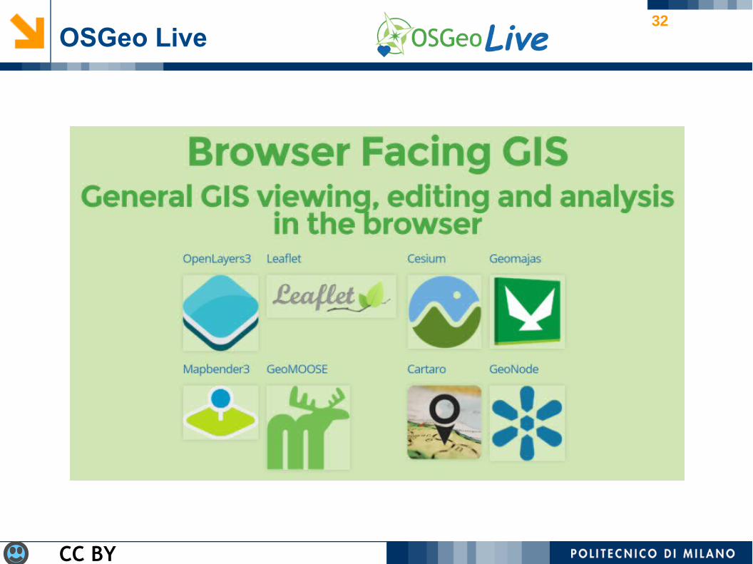
32OSGeo Live
CC BY

33OSGeo Live
CC BY

34OSGeo Live
CC BY

35OSGeo Live
CC BY
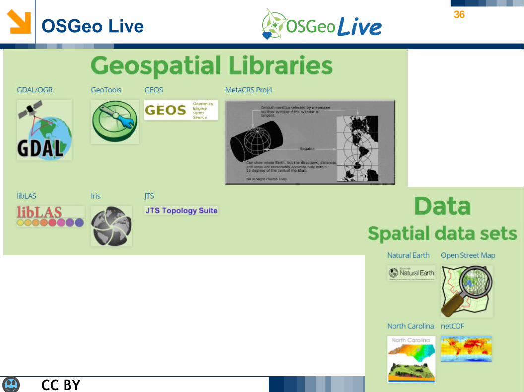
36OSGeo Live
CC BY

37Pillars of FE vision and its seven key focal outputs
(*) INNOVATION IN SUPPORTING TECHNOLOGY

38
Software function FOSS4G category FOSS4G examples
Geo-referenced data collection from specialized sensors
Integration, processing and distribution of sensor data (e.g OGC Sensor Observation Services SOS)
istSOS, 52°North SOS
Geo-referenced data collection from mobile devices and sensors (including citizen sensors)
Mobile and geo-crowdsourcing tools
Geopaparazzi, Open Data Kit (ODK)
Geosensing the World

39Organizing Geographic Information
Software function FOSS4G category FOSS4G examples
Desktop visualization and basic analysis
Desktop GIS QGIS, gvSIG, uDig, OpenJUMP, SAGA
Geodata storage Spatial Database Management Systems (DBMS)
PostgreSQL/PostGIS, SQLite/SpatiaLite, MySQL Spatial, MongoDB, CouchDB, Rasdaman
Geodata analysis and processing
Desktop geoprocessing and analysis tools
GRASS GIS, R, CyberGIS Toolkit
Serving geodata over the Web
Web-based GIS (e.g. OGC Web Services OWS)
GeoServer, MapServer, QGIS Server, deegree
Cataloguing geodata Web-based catalogue services (e.g. OGC Catalog Services for the Web CSW)
GeoNetwork, pyCSW

40
Software function FOSS4G category FOSS4G examples2D Web visualization 2D Web clients OpenLayers, Leaflet
3D Web visualization Virtual Globes NASA World Wind, Cesium, WebGL Earth, OpenWebGlobe
Web-based geoprocessing Web-based geoprocessing (e.g. OGC Web Processing Services WPS)
pyWPS, ZOO, 52°North WPS, GeoServer, deegree
Geography as a way to organize information

41
Software function FOSS4G category FOSS4G examples2D Web visualization 2D Web clients OpenLayers, Leaflet
3D Web visualization Virtual Globes NASA World Wind, Cesium, WebGL Earth, OpenWebGlobe
Web-based geoprocessing Web-based geoprocessing (e.g. OGC Web Processing Services WPS)
pyWPS, ZOO, 52°North WPS, GeoServer, deegree
Geography as a way to organize information
Brovelli M.A., Minghini M., Moreno R. and Oliveira R., 2016,Free and Open Source Software for Geospatial Applications (FOSS4G) to support Future Earth, International Journal of Digital Earth – in print

42
Contacts
Thanks for your attention!
Politecnico di Milano
Laboratorio di Geomatica – Polo Territoriale di ComoVia Valleggio 11, 22100 Como (Italy)
Thanks to all people of my team contributing on these topics, especially Marco Minghini and Giorgio Zamboni