Embed Size (px)
Citation preview
1
1
‘Water Security for Sustainable Development in a Changing Climate’
Discussion about water issues under changing climate
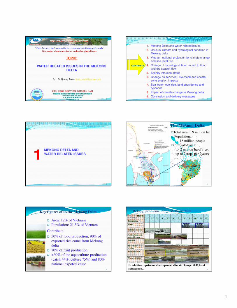
TOPIC:
WATER RELATED ISSUES IN THE MEKONG DELTA
By: To Quang Toan, [email protected]
VIỆN KHOA HỌC THỦY LỢI MIỀN NAM
Southern Institute of Water Resources Research658 Vo Van Kiet street, Dist 5, HCM city
Tel: 08 39238320 Fax: 0839235028
Webs: www.siwrr.org.vn 2
1. Mekong Delta and water related issues
2. Unusual climate and hydrological condition in Mekong delta
3. Vietnam national projection for climate change and sea level rise
4. Change of hydrological flow: impact to flood and dry season flow
5. Salinity intrusion status
6. Change on sediment, riverbank and coastal zone erosion impacts
7. Sea water level rise, land subsidence and typhoons
8. Impact of climate change to Mekong delta
9. Conclusion and delivery messages
CONTENTS
3
MEKONG DELTA AND WATER RELATED ISSUES1
4
Ú
Ú
Ú
Ú
Ú
Ú
Ú
ÚÚ
Ú
ÚÚ
ÚÚ
Ú
â
â
â
â
Pakse
Kratie
Ch©u §èc
Jinghong
Chiang SaenLuang Prabang
T©n Ch©u
H� Néi
Bangkok
Vientiane
Phnom Penh
Trung Quèc
Myanma
Th¸i Lan
Campuchia
ViÖt Nam
L�o
QuÇn ®¶o Ho�ng Sa
QuÇn ®¶o Tr−êng Sa
BIÓN §¤NG
BIÓN T¢Y
PhÇn th −î ng l−u t õ biª n giíi Tru ng Q
uèc vÒ ®Õn Kra tie
Ph Çn t h
−î ng l− u t h ué c Tru ng Qu èc v � M
ya nma
PhÇn th−îng l−u thuéc Campuchia ë d−íi Kratie
Vïng ®å ng b»n g C
h ©u thæ s«ng Mª C
« ng
§ång B»ng S«ng Cöu Long, ViÖt Nam
BiÓn hå Tonle Sap
C¸c ®Æc tr−ng chÝnh
DiÖn tÝch l−u vùc: 795.000 km (21)
ChiÒu d�i dßng chÝnh: 4.800 km (12)
L−u l−îng b×nh qu©n h�ng n¨m: 15.000 m /s
16%
2%
18%
35%
18% 11%
2
3
70 0 70 140 210 280 350 Kilometers
L−u vùc s«ng Mª C«ng h¹ thuéc L�o, Th i Lan, Campuchia v� VNTh−îng l−u tõ Trung Quèc ®Õn KratieTh−îng l−u §BSCL thuéc Campuchia sau Kratie§ång B»ng S«ng Cöu Long v� Phô cËnBiÓn Hå Tonle Sap
Th−îng l−u vùc s«ng Mª C«ng thuéc Trung Quèc v� MyanmaVïng Ch©u thæ Mª C«ngC¸c nh¸nh chÝnh trªn l−u vùc
Ú VÞ trÝ c¸c tr¹m quan tr¾c trªn dßng chÝnh Mª C«ngâ Th�nh phè, thñ ®«
Ranh giíi c c qu«c gia trong khu vùcDßng chÝnh s«ng Mª C«ng
S
N
EW
B¶N §å L¦U VùC S¤NG M£ C¤NG
GHI CHó
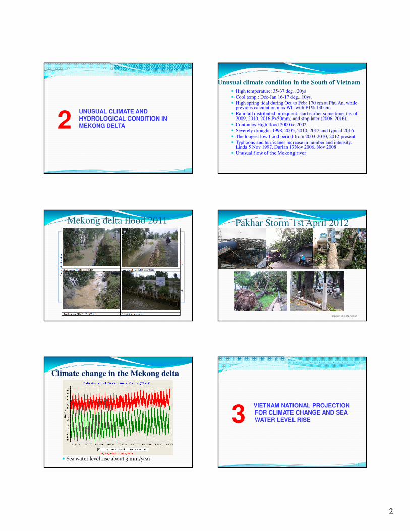
�Total area: 3.9 million ha
� Population:
18 million people
�Cultivated area:
> 2 million ha of rice,
up to 7crops per 2years
The Mekong Delta
Key figures of in the Mekong Delta
5
� Area: 12% of Vietnam
� Population: 21.5% of Vietnam
Contribute
� 50% of food production, 90% of
exported rice come from Mekong
delta
� 70% of fruit production
� >60% of the aquaculture production
(catch 44%, culture 75%) and 80%
national expoted value
Month
Problems1 2 3 4 5 6 7 8 9 10 11 12
Flood
Salinity Intrusion
Acid sulphate soil
and acid water
Drought
River bank
erosion
Sedimentation
Water pollution
Related problems in the Mekong delta
In addition: upstream development, climate change-SLR, land
subsidence… 6
2
7
UNUSUAL CLIMATE AND HYDROLOGICAL CONDITION IN MEKONG DELTA 2
Unusual climate condition in the South of Vietnam
� High temperature: 35-37 deg., 20ys
� Cool temp.: Dec-Jan 16-17 deg., 10ys.
� High spring tidal during Oct to Feb: 170 cm at Phu An, while previous calculation max WL with P1% 130 cm
� Rain fall distributed infrequent: start earlier some time, (as of 2009, 2010, 2016 P>50mm) and stop later (2006, 2016),
� Continuos High flood 2000 to 2002
� Severely drought: 1998, 2005, 2010, 2012 and typical 2016
� The longest low flood period from 2003-2010, 2012-present
� Typhoons and hurricanes increase in number and intensity: Linda 5 Nov 1997, Durian 17Nov 2006, Nov 2008
� Unusual flow of the Mekong river
Mekong delta flood 2011 Pakhar Storm 1st April 2012
Sources: www.nld.com.vn
Climate change in the Mekong delta
� Sea water level rise about 3 mm/year12
VIETNAM NATIONAL PROJECTION FOR CLIMATE CHANGE AND SEA WATER LEVEL RISE3

3
Biến đổi khí hậu - NBD
13
(MONRE 2016)
o RCP4.5:To increase 1,7oc*1,9oc, Rainfall increase 5*15%, SLR 32* 78 cmo RCP8.5:To increase 3,0oc*3,5oc, Rainfall increase >20%, SLR 48*106 cm
14
CHANGE OF HYDROLOGICAL FLOW FROM MEKONG RIVER: IMPACT TO FLOOD AND DRY SEASON FLOW
4
abnormal operation of hydropower dams
� Abnormal water storage may change a normal hydrological year to a droughty year and opposite way - may resulted from close dam at completed construction, trial operation, other purposes
15
3 operated perious of China dams in 2016 .
2: Hydrological change Dry season flow in 2015-2016
China dams operation
2nd times (from 23-28/2/2016)
3th (from
9/3/3016)
1st times (from 19-27/1/2016)
Operation scenario:
early/late water retention
� Early water retention operation may reduce the discharge at early stage of
rainy season, salinity water may happen a longer period
17
�Late water retention operation may reduce the discharge at early of dry season, salinity intrusion happen earlier dry season
Late storage water
Early storage water
Natural flow condition
With flow regulation
18
SALINITY INTRUSION STATUS5
4
Salinity intrusion in dry season 2015-2016
• Potential salinity intrusion (without salinity intrusion control systems) in 2015-2016
• Salinity concentration was too high ����aquaculture cultivation plan is inactively
Source: SIWRR
Salinity concentration was too high, over suitable thresholds for
shrimp cultivation
Orchard areas were affected by saline intrusion to reduce yield product
ProvinceNumber of
family(household)
Number of family lack of drink water
in 2016(household)
Percentage of family lack of
water (%)
Ben Tre 300.000 86.200 28.7
Soc Trang 311.000 43.000 13.8
Kien Giang 415.000 25.000 6
Tra Vinh 244.000 21.400 8.8
Long An 351.000 15.500 4.4
Ca Mau 289.000 14.500 5
Tien Giang 408.000 7.000 1.7
Bac Lieu 209.000 3.200 1.5
Vinh Long 247.000 2.500 1
Hau Giang 182.000 2.500 1.4
Total 220.800 7.5
B�n Tre, Sóc Trăng, Kiên Giang, Trà Vinh… Number of schools,
clinics hotels, factories were also lack of water supply
3: Salinity intrusion In recently period
Affected to drinking water supply in 2016
21
CHANGE ON SEDIMENT, RIVERBANK AND COASTAL ZONE EROSION IMPACTS6
TT Scenario Description
Sediment load at Kratie
(Mil ton)Reduction
vs 1998
condition
(%)
Reductio
n vs
present
conditio
n (%)
Max MinAverag
e
1 KB0 Baseline – China dams (CND) 97,0 34,0 59,6 63%
2 KB1 CND+Xayabury 89,3 31,5 54,5 66% 9%
3 KB3CND+ (Pakbeng, Luang
Prabang, Xayabury)81,7 28,4 48,3 70% 19%
4 KB10CND+ 10 mainstream
hydropower dams in Lao PDR58,3 21,3 34,9 78% 42%
5 KB12CND+ 12 mainstream
hydropower dams49,1 17,7 29,4 82% 51%
6 KB12+
CND+ 12 mainstream
hydropower dams+tributaries
dams
29,4 11,1 17,9 89% 58%
Other study (MDS) 13,88 mil tons
4: Change on sediment Impact of upstream development
Sediment change based on some simulation scenario (KC08.13/11-14, SIWRR)
4: Change on sediment Existing of mangrove forest belt
23
Lost 500 ha/year
24
SEA WATER LEVEL RISE, LAND SUBSIDENCE AND TYPHOONS7

5
25
5: Sea level rice, land subsidence and typhoon
Land subsidence
To what extent? 1.6 – 2.5 cm/year
Delta now faces the twin threats of subsidence and rising sea
levels.
Sinking at rates many times faster than global sea level is rising”.
Sea water level rise (1,6-2cm/year??)
Station PeriodRate of Sea WLR
(mm/year)
Vũng
Tàu1980-2015 4.85
Gành
Hào
1996-2015 16.6
2000-2015 19.6 (2cm/year)
Sông
�c
1996-2015 13.3
2000-2015 11
R�ch
Giá
1996-2015 2.9
2000-2015 5.3
(Na Uy: 1,9 – 2,8 cm/năm) (ICEM: 1,9 –
2,8 cm/năm)
Natinal projection for sea level rise:2100: 100 cm
2030: 17 cm
Max high of wave in KB1 (level 13): 3.5 m
WAVE LEVEL IN TYPHOON
5: Sea level rice, land subsidence and typhoon
Typhoon
e.g: Typhoon wind speed level 13
Distribution of water level rise in high typhoon
KB1 (level 13)
5: Sea level rice, land subsidence and typhoon
Typhoon
e.g: Typhoon wind speed level 13
28
IMPACT OF CLIMATE CHANGE TO MEKONG DELTA8
Agriculture and aquaculture development in Mekong delta
29
Change of salinity intrusion by
concentration in simulated scenarios
6
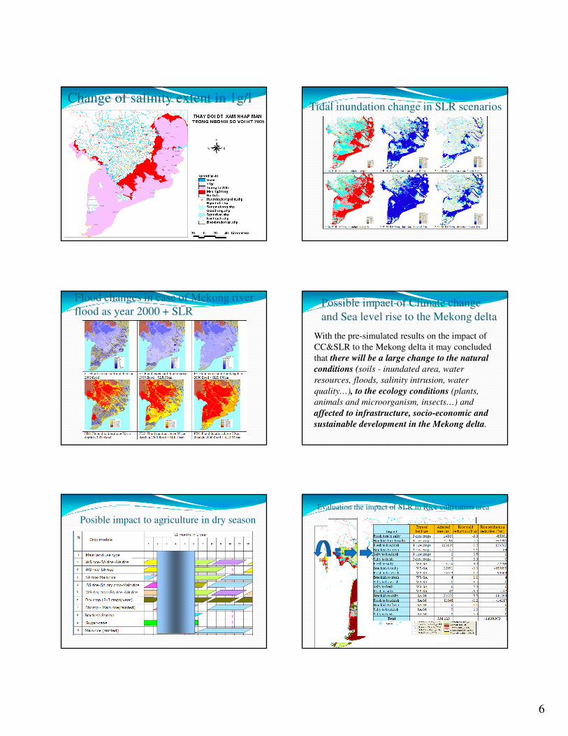
Change of salinity extent in 1g/lTidal inundation change in SLR scenarios
Flood changes in case of Mekong river
flood as year 2000 + SLRPossible impact of Climate change
and Sea level rise to the Mekong delta
With the pre-simulated results on the impact of
CC&SLR to the Mekong delta it may concluded
that there will be a large change to the natural
conditions (soils - inundated area, water
resources, floods, salinity intrusion, water
quality…), to the ecology conditions (plants,
animals and microorganism, insects…) and
affected to infrastructure, socio-economic and
sustainable development in the Mekong delta.
Posible impact to agriculture in dry season
Evaluation the impact of SLR to Rice cultivation area
7
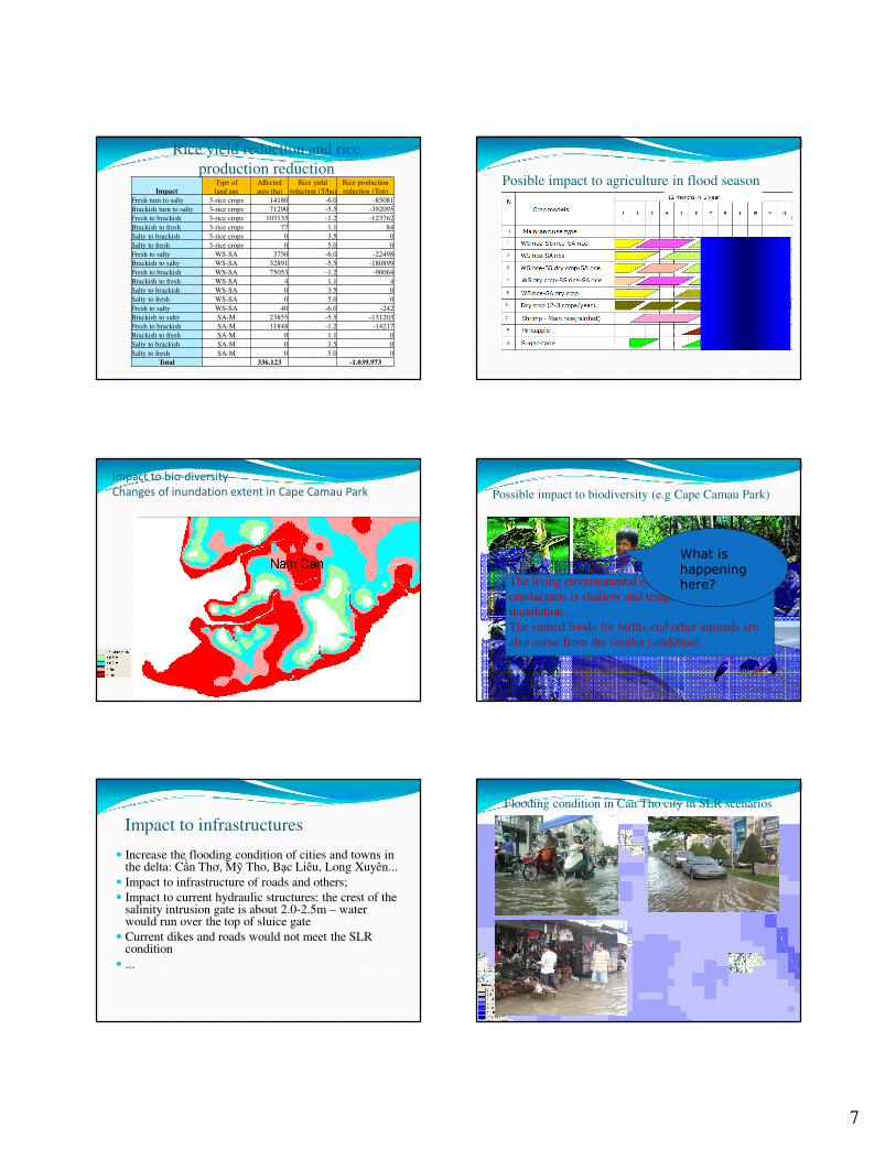
Rice yield reduction and rice
production reduction
Impact
Type of
land use
Affected
area (ha)
Rice yield
reduction (T/ha)
Rice production
reduction (Ton)
Fresh turn to salty 3-rice crops 14180 -6.0 -85081
Brackish turn to salty 3-rice crops 71290 -5.5 -392095
Fresh to brackish 3-rice crops 103135 -1.2 -123762
Brackish to fresh 3-rice crops 77 1.1 84
Salty to brackish 3-rice crops 0 3.5 0
Salty to fresh 3-rice crops 0 5.0 0
Fresh to salty WS-SA 3750 -6.0 -22498
Brackish to salty WS-SA 32891 -5.5 -180899
Fresh to brackish WS-SA 75053 -1.2 -90064
Brackish to fresh WS-SA 4 1.1 4
Salty to brackish WS-SA 0 3.5 0
Salty to fresh WS-SA 0 5.0 0
Fresh to salty WS-SA 40 -6.0 -242
Brackish to salty SA-M 23855 -5.5 -131203
Fresh to brackish SA-M 11848 -1.2 -14217
Brackish to fresh SA-M 0 1.1 0
Salty to brackish SA-M 0 3.5 0
Salty to fresh SA-M 0 5.0 0
Total 336.123 -1.039.973
Posible impact to agriculture in flood season
Impact to bio-diversity
Changes of inundation extent in Cape Camau Park Possible impact to biodiversity (e.g Cape Camau Park)
The living environmental condition for reptiles and
crustaceans is shallow and temporary daily
inundation.
The earned foods for births and other animals are
also come from the similar conditions.
What is happening here?
Impact to infrastructures
� Increase the flooding condition of cities and towns in the delta: Cần Thơ, Mỹ Tho, Bạc Liêu, Long Xuyên...
� Impact to infrastructure of roads and others;
� Impact to current hydraulic structures: the crest of the salinity intrusion gate is about 2.0-2.5m – water would run over the top of sluice gate
� Current dikes and roads would not meet the SLR condition
� ...
Flooding condition in Can Tho city in SLR scenarios

8
Flood warning mark
44
CONCLUSION AND DELIVERY MESSAGES9
45
Inside Mekong delta: Land subsidence/ tidal
inundation/ salinity intrusion/ drought/water
quality…
6: Challenges: Conclusion
Delivery messages
The
Main stream
Mekong hydro�power
cascadesCut
‘Mekong Mekong Mekong Mekong
DragonDragonDragonDragon’
INTO
PIECES
- loss the God’s Gift to Mekong’ people: water with natural flow, protit and fertilizers
- loss the ability to forecast and do early warning for floods and drought. – With reservoir water levels can not predict the real discharge.
Mekong hydropower Cascades cause a considerable losses of sediments, fisheries, agriculture causing drought, salinity intrusion, erosion, environmental problems.
Water resources development in the Mekong basin needs an integrated approach.
Give a hand to save the Mekong River!46