Embed Size (px)
Citation preview
Nguyen Van Lap1*, Ta Thi Kim Oanh, Yoshiki Saito21Institute of Resources Geography, Vietnam Academy of Science and Technology- VAST
2MRE Geological Survey of Japan, AIST, Tsukuba, Japan* e-mail: [email protected]
Sedimentation processes in the Mekong River Delta, Vietnam

• Morpho- sedimentology of the Mekong River Delta
• Sedimentation process in the coastal areas of active delta plain, Ben Tre and Tra Vinh provinces
• Sedimentation process in the coastal areas of delta margin, Ca Mau area

• Morpho- sedimentology of the Mekong River Delta
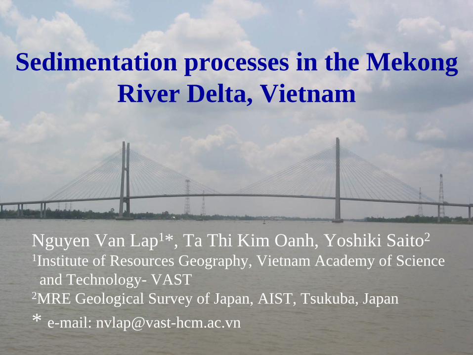
Catchment area: 795,000 km2
Main stream length: 4,800 kmMean flow: 14,500 m3/sRun off: 575 mm
Delta area: 62,520 km2 Mean tidal range: 2.5 mMean wave height: 0.9 mWater discharge: 470 km3/ySediment discharge: 160 million ton/y

Semi- diurnal tiderange 2.8-3.8m
- Northeast monsoon(Nov – Mar)
- Southwest monsoon(May – Oct)
Diurnal tide, range 0.6-0.8m

Annual to decadal environmental change and current sedimentary process
1) morphological change analysis of the coastal zone 2) sedimentological analysis of the coastal zone 3) satellite imagery analyses for land use & coastal zone
changes.
Natural changes
Human impacts
MillennialCentennial
Decadal Future
Millennial Centennial Decadal Future
CHANGES
Environmental changes and geological assessment in the coastal zone of Mekong River Delta

Tide-wave dominated
tide dominated

Coastal environmentsa/ Tide – wave dominated coast
(Ben Tre, Tra Vinh areas)- sand dune and beach ridge- coastal plain- mangrove swamp- tidal flat
b/ Tide dominated coast (Ca Mau area)- mangrove swamp- tidal flat
• Sedimentation process in the coastal areas of active delta plain, Ben Tre and Tra Vinh provinces

Period Erosionarea
Deposition area
Total area
Average
1972 - 1987 -524 +2,913 +2,389 159
1987- 1996 -670 +1,281 +611 68
1996 - 2004 -367 +1,203 +836 104
1972 - 2004 -1,561 +5,397 +3,336 105
Deposition and erosion areaat BenTre coast (ha)
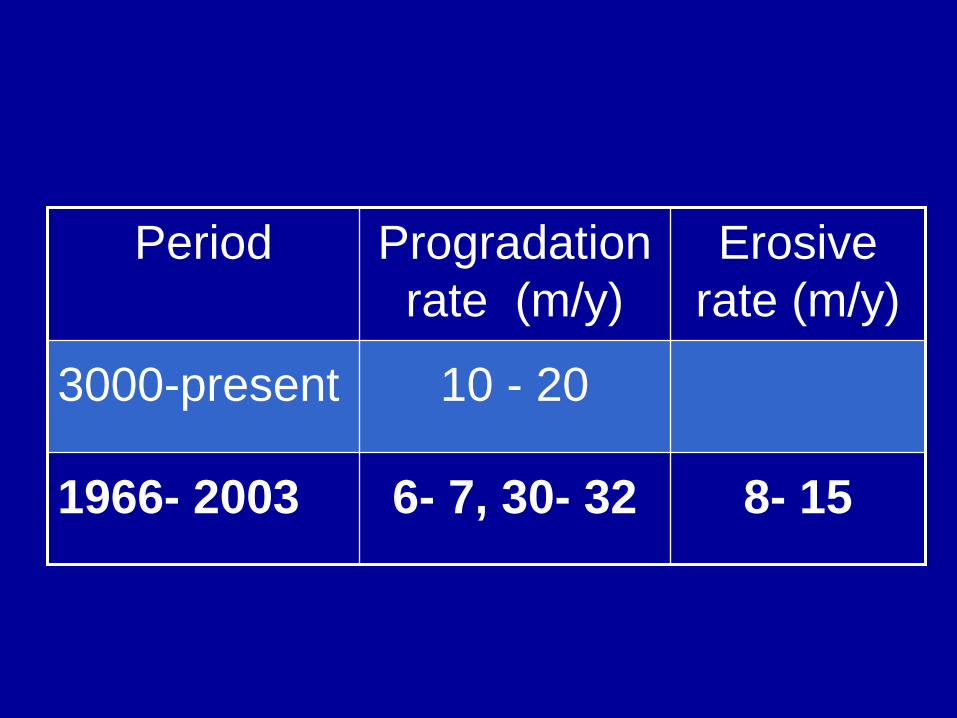
Period Progradation rate (m/y)
Erosive rate (m/y)
3000-present 10 - 20
1966- 2003 6- 7, 30- 32 8- 15

Depositional coast
erosive coast
• Sedimentation process in the Ca Mau coastal areas, delta plain margin

Land use map in Ca Mau cap in 2003
Mangroveforest
Forest - shrimp farm
Shrimp farm
Shrimp farm - forest
Mangroveforest
0 10 km

Deposition and erosion area at Ca Mau coast (ha)
PeriodErosion
area(eastern)
Deposition area
(western)Total area
Aver-age
1885 - 1940 -6,494 +5,875 -619 -11.2
1940 - 1965 -2,344 +3,181 +837 +33.5
1965 - 1985 -2,427 +3,189 +762 +38.0
1985 - 1998 -1,625 +1,401 -223 -17.0
1885 - 1998 -12,890 +13,646 +756 +6.70

erosive coast
Depositional coast
1) Beach profile is a good indicator showing erosional/depositional status of the coast.Beach profile change from depositional to erosional coasts will occur before serious shoreline erosion. It will be very important to mitigate coastal erosion and take its measures. To survey all beach profiles for understanding the present status and monitoring of key areas are recommended.
Conclusion
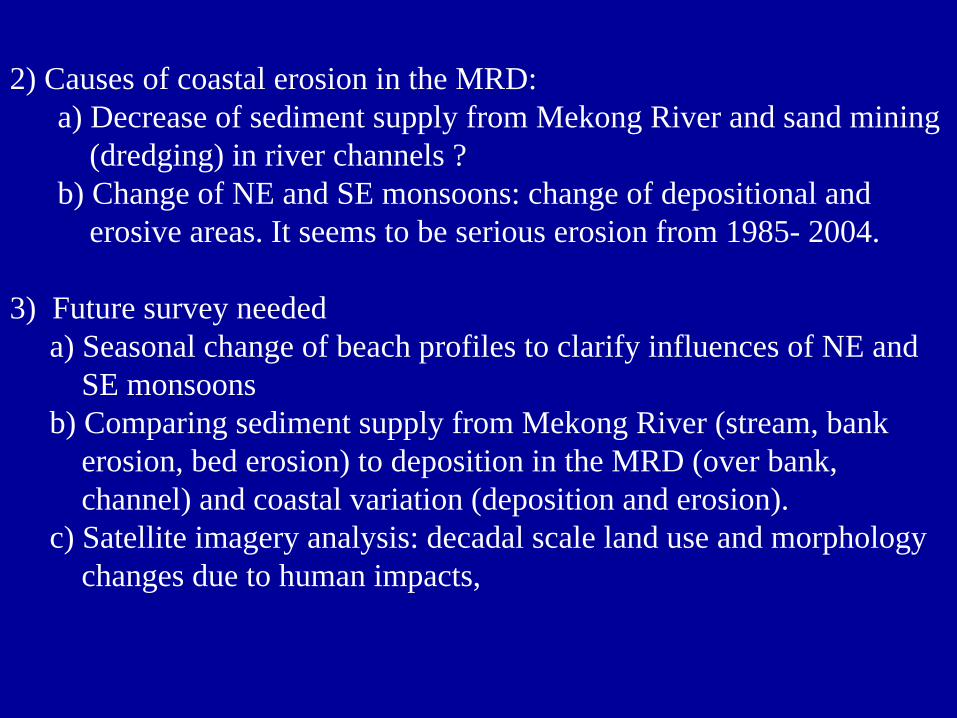
2) Causes of coastal erosion in the MRD: a) Decrease of sediment supply from Mekong River and sand mining
(dredging) in river channels ?b) Change of NE and SE monsoons: change of depositional and
erosive areas. It seems to be serious erosion from 1985- 2004.
3) Future survey neededa) Seasonal change of beach profiles to clarify influences of NE and
SE monsoonsb) Comparing sediment supply from Mekong River (stream, bank
erosion, bed erosion) to deposition in the MRD (over bank, channel) and coastal variation (deposition and erosion).
c) Satellite imagery analysis: decadal scale land use and morphology changes due to human impacts,