The geochemistry of Arus & Bogoria geothermal prospects
1st EAST AFRICAN RIFT GEOTHERMAL CONFERENCE –ARGeo-C1
GEOLOGICAL SURVEY OF ETHIOPIA,24TH NOV– 2ND DECEMBER, 2006
C. Karingithi
2ARGeo-C1
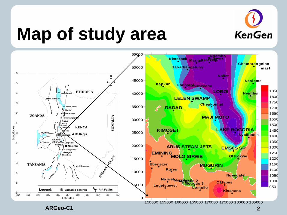
Map of study area
150000 155000 160000 165000 170000 175000 180000 1850000
5000
10000
15000
20000
25000
30000
35000
40000
45000
50000
55000
LOBOI
MAJI MOTO
LAKE BOGORIA
EMS0S SP
MUGURIN
ARUS STEAM JETS
MOLO SIRWEEMINING
KIMOSET
RADAD
LELEN SWAMP
Kapkun
Kimorock
Chepkoimet
Kailer
Kures
Marigat
Chebaral
Ebenezer
Tabarbangetuny
Noiwet
LegetetewetOldebes
Ngendalel
Nyalilpush
Ol Kokwe
Mogotio 1Mogotio 2Mogotio 3
LomolloKisanana
Tabarweche
Chemorongnion
Sosionte
Nyimbei
IlngaruaNgambo
Perekera
950
10001050
11001150
12001250
13001350
14001450
15001550
16501700
17501800
1850
masl
32 33 34 35 36 37 38 39 40 41 42Latitudes
-6
-5
-4
-3
-2
-1
0
1
2
3
4
5
6
Long
itude
s KENYA
Mt. Kenya
L. Magadi
SuswaLongonotOlkaria
Eburu
Menengai
Paka
Barrier
Silali
L. Victoria
Mt. Kilimanjaro
Emuruangogolak
Namarunu
KorosiL. Baringo
Bogoria
UGANDA
ETHIOPIA
SOM
AL
IA
TANZANIA
Shombole
Olorgesaille
South Island
Central Island
North Island
Nyanza
Nairobi
Legend: Rift FaultsVolcanic centres

3ARGeo-C1
Aerial Photo of BogoriaProspect
4ARGeo-C1
OBJECTIVE
Locate and map all geothermal surface manifestations.Establish the whether a geothermal resource exists in Arus and Bogoria prospects. Site exploration wells.

5ARGeo-C1
Locate, sample and analyse the springs, fumaroles, boreholes and gas holesSoil gas survey.Ground temperature.
Surface exploration Methodology

6ARGeo-C1
Arus steam jets

7ARGeo-C1
Bogoria geysers

8ARGeo-C1
Bogoria fumaroles

9ARGeo-C1
Work done to date
Located and Sampled EIGHTEEN (18) springsLocated and Sampled 31 boreholes338 radom radon and soil gas measurements Located and sampled ten fumaroles

10ARGeo-C1
Location of all sampling points
150000 155000 160000 165000 170000 175000 180000 1850000
5000
10000
15000
20000
25000
30000
35000
40000
45000
50000
55000
LOBOI
MAJI MOTO
LAKE BOGORIA
EMS0S SP
MUGURIN
ARUS STEAM JETS
MOLO SIRWEEMINING
KIMOSET
RADAD
LELEN SWAMP
Kapkun
Kimorock
Chepkoimet
Kailer
Kures
Marigat
Chebaral
Ebenezer
Tabarbangetuny
Noiwet
LegetetewetOldebes
Ngendalel
Nyalilpush
Ol Kokwe
Mogotio 1Mogotio 2Mogotio 3Lomollo
Kisanana
Tabarweche
Chemorongnion
Sosionte
Nyimbei
IlngaruaNgamboPerekera
950
10001050
1100
1150
12001250
1300
1350
1400
14501500
1550
1650
17001750
1800
1850
masl

11ARGeo-C1
Boreholes and springs temperature distribution plot
150000 155000 160000 165000 170000 175000 180000 1850000
5000
10000
15000
20000
25000
30000
35000
40000
45000
50000
55000
LOBOI
MAJI MOTO
LAKE BOGORIA
EMS0S SP
MUGURIN
ARUS STEAM JETS
MOLO SIRWEEMINING
KIMOSET
RADAD
LELEN SWAMP
25
2627
2829
3031
3233
3435
3637
4045
5075
100
Deg C
12ARGeo-C1
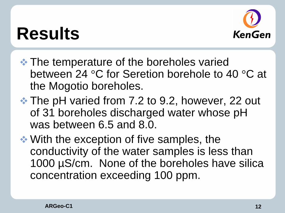
ResultsThe temperature of the boreholes varied between 24 °C for Seretion borehole to 40 °C at the Mogotio boreholes.The pH varied from 7.2 to 9.2, however, 22 out of 31 boreholes discharged water whose pH was between 6.5 and 8.0.With the exception of five samples, the conductivity of the water samples is less than 1000 µS/cm. None of the boreholes have silica concentration exceeding 100 ppm.

13ARGeo-C1
Chloride-Sulphate-Bicarbonate ternary diagram
0 25 50 75 100HCO3
100
75
50
25
0
Cl
100
75
50
25
0
SO4
14ARGeo-C1
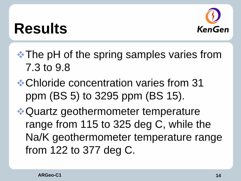
ResultsThe pH of the spring samples varies from 7.3 to 9.8 Chloride concentration varies from 31 ppm (BS 5) to 3295 ppm (BS 15).Quartz geothermometer temperature range from 115 to 325 deg C, while the Na/K geothermometer temperature range from 122 to 377 deg C.

15ARGeo-C1
Arus & Bogoria Soil gas Radon 220 distribution plot
150000 155000 160000 165000 170000 175000 180000 1850000
5000
10000
15000
20000
25000
30000
35000
40000
45000
50000
55000
Kapkun
Kimorock
Chepkoimet
Kailer
Kures
Marigat
Chebaral
Ebenezer
Tabarbangetuny
Noiwet
LegetetewetOldebes
Ngendalel
Nyalilpush
Ol Kokwe
Mogotio 1Mogotio 2Mogotio 3Lomollo
Kisanana
Tabarweche
Chemorongnion
Sosionte
Nyimbei
IlngaruaNgambo
Perekera
LOBOI
MAJI MOTO
LAKE BOGORIA
EMS0S SP
MUGURIN
ARUS STEAM JETS
MOLO SIRWEEMINING
KIMOSET
RADAD
LELEN SWAMP
0
200400
600800
12001500
18002000
25003000
35004000
45005000
60007500
10000
CPM
16ARGeo-C1
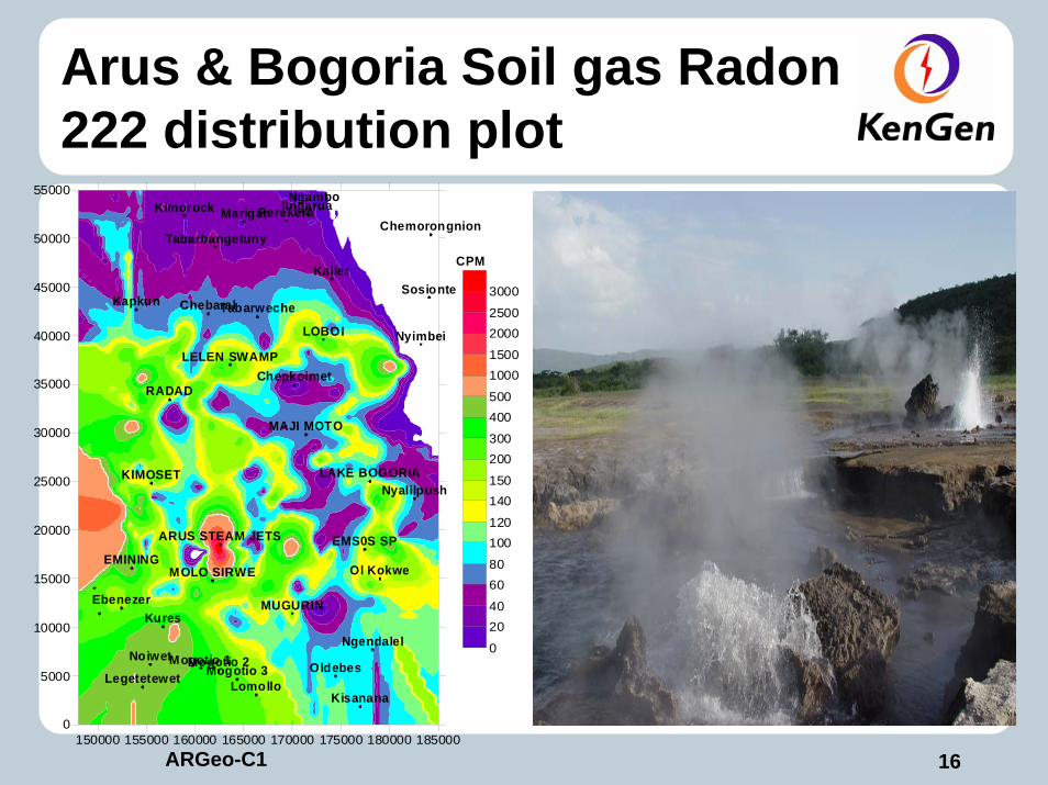
Arus & Bogoria Soil gas Radon 222 distribution plot
150000 155000 160000 165000 170000 175000 180000 1850000
5000
10000
15000
20000
25000
30000
35000
40000
45000
50000
55000
Kapkun
Kimorock
Chepkoimet
Kailer
Kures
Marigat
Chebaral
Ebenezer
Tabarbangetuny
Noiwet
LegetetewetOldebes
Ngendalel
Nyalilpush
Ol Kokwe
Mogotio 1Mogotio 2Mogotio 3Lomollo
Kisanana
Tabarweche
Chemorongnion
Sosionte
Nyimbei
IlngaruaNgambo
Perekera
LOBOI
MAJI MOTO
LAKE BOGORIA
EMS0S SP
MUGURIN
ARUS STEAM JETS
MOLO SIRWEEMINING
KIMOSET
RADAD
LELEN SWAMP
0
2040
6080
100120
140150
200300
400500
10001500
20002500
3000
CPM
17ARGeo-C1
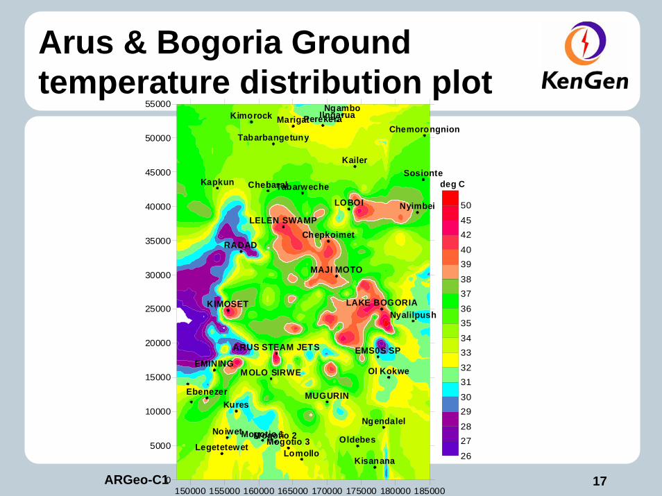
Arus & Bogoria Ground temperature distribution plot
150000 155000 160000 165000 170000 175000 180000 1850000
5000
10000
15000
20000
25000
30000
35000
40000
45000
50000
55000
Kapkun
Kimorock
Chepkoimet
Kailer
Kures
Marigat
Chebaral
Ebenezer
Tabarbangetuny
Noiwet
LegetetewetOldebes
Ngendalel
Nyalilpush
Ol Kokwe
Mogotio 1Mogotio 2Mogotio 3
LomolloKisanana
Tabarweche
Chemorongnion
Sosionte
Nyimbei
IlngaruaNgambo
Perekera
LOBOI
MAJI MOTO
LAKE BOGORIA
EMS0S SP
MUGURIN
ARUS STEAM JETS
MOLO SIRWEEMINING
KIMOSET
RADAD
LELEN SWAMP
26
2728
2930
3132
3334
3536
3738
3940
4245
50
deg C
18ARGeo-C1
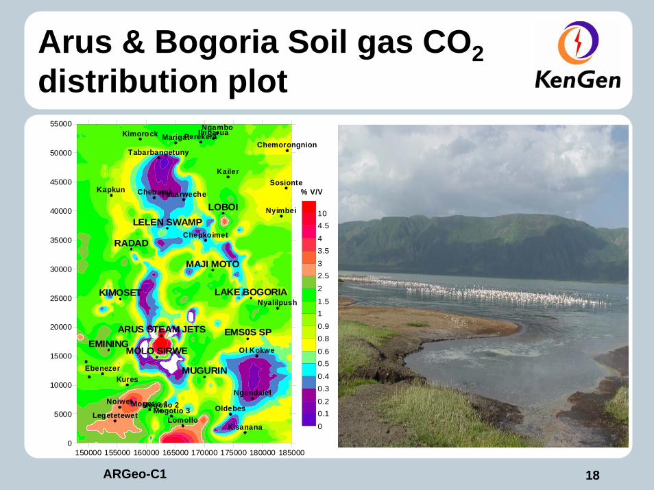
Arus & Bogoria Soil gas CO2distribution plot
150000 155000 160000 165000 170000 175000 180000 1850000
5000
10000
15000
20000
25000
30000
35000
40000
45000
50000
55000
Kapkun
Kimorock
Chepkoimet
Kailer
Kures
Marigat
Chebaral
Ebenezer
Tabarbangetuny
Noiwet
LegetetewetOldebes
Ngendalel
Nyalilpush
Ol Kokwe
Mogotio 1Mogotio 2Mogotio 3
LomolloKisanana
Tabarweche
Chemorongnion
Sosionte
Nyimbei
IlngaruaNgamboPerekera
LOBOI
MAJI MOTO
LAKE BOGORIA
EMS0S SP
MUGURIN
ARUS STEAM JETS
MOLO SIRWEEMINING
KIMOSET
RADAD
LELEN SWAMP
0
0.10.2
0.30.4
0.50.6
0.80.9
11.5
2
2.53
3.54
4.510
% V/V
19ARGeo-C1
CONCLUSIONSA GEOTHERMAL RESOURCE EXISTS IN ARUS AND BOGORIA,145–325 deg CTHE UPFLOW MAY BE LOCATED IN THE AREA CLOSE TO THE ARUS STEAM JETS AND THE AREA NORTH OF MUGURIN. High radon and ground temperature.

20ARGeo-C1
AcknowledgementsSpecial thanks to the Management of Kengen for allowing us to publish this paper
Thank you very much
Have a wonderful WEEK
Recommended