56
56
56
869
869
869
160
56
56
403
403
56
403
403756
271
271
1700
1600
1800
1500
1800
1400
1200
2500
2000
2100
2200
2300
2400
2000
2500
2400
2400
2100
0032
2700
2700
2700
2600
2400
2500
2600
2600
2500
2400
2100
2000
1900
2700
2200
1600
1900
1600
1700
1800
1800
1500
16001700
2100200019
00
1800 2000
2100
2200
1900
2400
27002600
250024
00230022
00
21002200
220021
00
20001900
2500
2500
2200
2300
2400
2600
2600
2400
24002500
2600
2700
2500
2600
2700
210022
0023
00250027
00
2000
1900
1800
1700
2700
2700
2700
2600
2600
2500
2800
19002000
2700
2600 25
00
2800
2800
2600
2500
2700
2800
0032
2400
2500
2600
2700
2400
1900
2100
2100
1800
1900
2000
2100
2200
2100
2000
1800
2100
1900
2000
2000
1800
1700
17001800
2700
2600
2500
2400
21002200
2300
2600 2400
2500
2600
27002600
2500
2200
2600
27002500
2600
25002500
2000
2100
2200
2200
2300
2400
1900
2200
2200
2100
2100
1800
2000
1900
1800
1700
2100 2200 2300
24002500
2500
1900 20001800
2300
2200
CAMBRIA COUNTYSOMERSET COUNTY
SOM
ERSE
T C
OU
NTY
BED
FORD
CO
UN
TY
John MurthaJohnstown
Cambria CountyAirport
Rummel
Blough
Benson
MapleRidge
Tire Hill
Daisytown
Foustwell
Hagevo
St. Michael
Krings
Belmont
Lorain
Oakland
Elton
Parkstown
Krayn
Llanfair
Salix
Allendale
Lloydell
Onnalinda
HollsoppleSeanor
NewAshtola
Dunlo
Beaverdale
Eureka
Ogletown
Dale
Paint
ScalpLevel
Geistown
Ferndale
Riverside
Windber
Johnstown
STATE GAME LANDS 26
CLEAR SHADEWILD AREA
BABCOCK DIVISION
Luzerne St.
State Hwy 756
Scalp Ave
17thSt
18thSt
rade
CSt.
Hu� St.
Dr.
Hillsboro Rd
Ridge Rd
Blough Rd
Camp Dr
Pipeline
Road
Pine Blu� Rd
State
Hwy 4
03
1st St
Eisenhower Blvd
Eisenhower Blvd
Frankstown Rd
Bedford St
Singer
Hill
Rd
HickorySt.
Krings S
t
Bedford St.
State Hwy 756
Main St.
Barnett St
Summit Ave Clay St
Krayn Road
Willi
am
Gilber
t St
.
Millcreek Rd.
Washington St.
Llan
fair
Roa
d
Peaceful Valley Road
Rhodes Cross Rd.
Seesetown Road
Sees
etow
n
Road
Sugar
Maple Drive
Babcock Park Dr.
Centennial Drive
RailroadSt.
Centennial Drive
Graham Ave.
Stat
ler
R
oad Spruce
St.
Louella DriveLouella Drive
Verla Drive Verla Drive
Berk
ey
Road
Morning Land Drive
Ash
tola Drive
Mount Carm
el Drive
Hol
low
R
oad
Crescent
Ryot Road
Arrow Rd.
Hill
sbor
o Road
Cameron
Ave.
Krayn Road
Mine 42 Road
Mine 42 Road
Old Bedford Pike
Old Bedford Pike
Skyline Drive
Bual
o R
oad
Handicap Hunter Road
Strip
Min
e R
oad
Strip Mine Road
Babc
ock
Creek Rd.
Old Bedford Pike
Saddle Club Road
Petia
Roa
d
Hayes St.
Basin Drive
Crumb Road
Shade Road
Shad
e
Roa
d
Stout Rd.
Cub Run Road
Sum
mit
Driv
e
Mount Carm
el
Driv
e
Hollow
Rd.
HatcheryFish
Rd.
Bu alo Road
Bual
o
Road
Skyline
D
r.
Mou
ntai
n
Road
Pleasant Hol. Rd.
Calvary Hollow Road
Spru
ce H
ollow Road
Osman Road
Oldham Road
Dunkard Hollow
Road
Mou
ntain
Spr
ings
Road
Short Cut Road
Barefo ot Road
Calvary Hollow
Road
GeorgeCreekRoad
enaL yrtnuoC
Huff St.
Dunlo
B
ypas
s
Dun
lo
B
ypass
Krayn Connection Road
Babcock C
reek Rd.
StoutExtension
ROUNDTOP
P O T R I D G E
BRIERKNOB
Laurel Run
South Fork
SandyRun
Spruce
Run
Kaufman Run
Paint
Creek
Sams
Run
Falls Run
Solomon Run
Little Paint
Cr.
River
unknown
Stoney Creek
Stoney Creek
unknown
Clapboard Run
unkn
own
Paint Creek
Sams Run
Spru
ce Run
unknown
unknown
unknown
Little
Pain
t Cre
ek
unknown
unknown unknown
unknown
unknown
unknown
unkn
own
Sandy Run
Solomons Run
Sand
y Run
Solomons Run
unknown
Elk Run
Stony Cr.
ConemaughLittle
R.
Beaverdam Run
S. Fork Little Conemaugh River
Otto
R
un
Sulphur Creek
Sulphur Run
Dunlo Dip
Road
Otto Run
Beav
erda
m R
un
Rachel
Run
Bottle
Ru
n
South Fork L ittle Conemaugh River
Paint Creek
Paint Creek
Paint Creek
Babcock Creek
Seese Run
Little Paint Creek
Seese Run
RoaringFork
Weaver Run
Roar
ing
For
k
Roarin
g Fork
Clea
r Sh
ade
Creek
Cub Run
Clear Shade
Cr.
Gordon Creek
Shade Cr.
South Fork Little Conemaugh River
BeaverdamReservoir
BeaverdaleReservoir
PineLake
Inclined Plane
Bog
Path
Tr.
Bog
Path
Trai
l
County Line Tr.
County Line TrailCounty
L
ine
Trai
l
County
Line
T
rail
Lost
Turk
ey T
rail
Lost
Turk
ey T
rail
Lost Turkey Trail
Lost Turkey Trail
John P. Saylor Trail
John P. Saylor
Trail
John
P. Saylor Trail
John P. Say lor Tr.
Babcock Picnic Area
WolfRocks
To Blue Knob State Park,Pavia
To Blue Knob State ParkTo PA Turnpike I-70/76 Exit 146, Bedford
To PA
56, Win
dber, U
S 219
To W
indber
, PA 160, U
S 219
To PA
160
To PA
160
To PA
160
To Beaverdale, US 219
To J
ohn Murth
a Johnsto
wn-Cam
bria
County A
irport,
US 2
19, Win
dber
To Central City, US 3078°50' 78°48' 78°46' 78°44' 78°42' 78°40'
78°56'
78°44'
78°46'
78°48'
78°50'
78°52'
40°14'
40°12'
40°16'
40°18'
78°42' 78°40'
40°20'
40°18'
40°16'
40°14'
40°12'
40°18'
1
1
0
0 1 2 MILES
1 2 3 KILOMETERS
SCALE: 1" = APPROX. 2/3 MILE
Both maps (and district o�ce map) are shown at the same scale.
Map Datum: World Geodetic System 1984 (WGS 84)
At this scale, the boundary details are limited and some small private parcels within state agency lands are not shown on
this map. There are many areas of private lands withinthe boundaries of public owned areas. Please respect the
rights of private property owners.
N
56
403
56
403
869
869
56
56
403
403
56
403
403756
271
271
271271
271
403
711
2222
22
19001400
15001600
1700
1600
1700
1800
1900
2000
2100
2200
2300
2400
16001700
1700
1700
18001900
1900
1900
1900
1800
1700
1900
24002300
22002100
2000
1900
1800
2200
1700 1800
1900
20001900
1800
2000
2000
1900
1300
1400
1500
1600
1700
2000
1300
1400
1500
1600
1700
1200 13
0014
00
14001500
16001700
1800
1500
1600 17
00
1300
1700
2200
21002000
190018
00170016
00
1300
1400
16001500
23002200
2200 2200
23002400
2400
2500
2400
2000
1900
1800
1700
1600
1500
1400
1300
21002200
2300
12001300
2200
2100
2200
1900
1900
2400
2500
2500
1500
1600
1700
1800
1900
2000
2100
2200
2300
2400
1800
180015001600
1700
1900
1400
1500
1600
170018
00
1800
1600
1600
1900
1400
1700
1700
16001500
2600
2600 2400
25002200
12001300
14001500
16001700
18001900
2000
2100
14001600
20002000200020002000
2500
1800
18001700
1600
1700
1600
15001400
1300
1200
1600
1200
13001400
1800
1500
1500
1800
190018001700
1600
1500
1400
1200
2000
2100
2200
2300
2200
2600
2500
2000
2100
2200
2200
2300
2400
1900
2100
1800
2000
1900
1800
1700
1900 20001800
2300
WES
TMO
RELA
ND
CO
UN
TY
CAM
BRIA
CO
UN
TY
IND
IAN
A C
OU
NTY
CAM
BRIA
CO
UN
TY
WESTM
ORELAN
D CO
.
John MurthaJohnstown
Cambria CountyAirport
Daisytown
Brownstown
Morrellville
Eastmont
St. Michael
Belmont
Lorain
Oakland
Parkstown
Franklin Wissingertown
Parkhill
Llanfair
Salix
Allendale
Rockville
Dunlo
Cramer
GoodsCorner
Echo
WestPoint
WesleyChapel
Vinco
Fairview
Chickory
Mineral Point
Mundys Corner
Wilmore
New Germany
Ehrenfeld
Soukesburg
Summerhill
Hinck
ston
Run
Dale
South Fork
Geistown
EastConemaugh
Ferndale
Westmont
Johnstown
S.G.L. 42
S.G.L. 79
S.G.L.79
S.G.L. 79
LAURELRIDGESTATEPARK
CHARLES F. LEWISNATURAL AREA
RAGER MOUNTAIN DIVISION
Luzerne St.
D St.
State Hwy 756
Scalp Ave
Pike Road
Hu� St.
Dishong M
ountain R
oad
Pipeline
Road
Was
hing
ton
Ave
Pine Blu� Rd
State
Hwy 4
03
Frankstown Rd
Bedford St
Singer
Hill
Rd
HickorySt.
4thAve
.
Beech Hill Rd
Mineral Point Rd Mineral Point Rd
Locust St.
Bedford St.
State Hwy 756
LaurelAve.
Virginia Ave.
Main St.
Barnett St
Summit Ave Clay St
Grange Hall
Road
Mile H
ill Road
Swigle M
ountain Road
Chickoree Hill Road
Stutzman
Road
Deyarm
in R
d.
Griffith Road
Weh
rum
R
oad
Dishong M
ount
ain
Roa
d
Coop
er A
ve.
Cooper Ave
.
Tollgate Road
Sharkey RoadBenshoff Hill
Road
Bens
hoff
Hill
Ro
ad
Benshoff H
ill R
oad
Willi
am
Penn
A
ve.
Willi
am
P
enn Ave.
Decker Ave.
Fairf
ield
Ave. Ga
rfiel
d
St.
Saint Clair Rd.
Saint Clair
Rd.
Goucher
S
t.
Iron St.
Gilber
t St
.
Millcreek Rd.
Orchard
St.
Roa
d
Peaceful Valley Road
Rhodes Cross Rd.
Seesetown Road
Sees
etow
n
Road
Chestnut St.
Gas C
ompany Rd.
Cernic Rd.
Wildcat Rd.
La
urel
Run R
oad
Laurel Run Road
Whitetail Road Pike Road
Cardi St.
Waterfall Dr.
Hunt Rd.
Kepple Road
Hin
cksto
n
Run
R
oad
Mack Ave.
Sadie St.
Blackburn Rd.
Adams Ave.
Leidy Lane
Bracken S
t.
Waterfall Dr.
Decker Ave.
Mountain Road
Mountain Rd.
tia R
oad
Laurel Run Rd.
Laurel Run Stripmine Rd.
Rager Mtn. Road Gas
Com
pany Rd.
Stevenson Farm Road
Huff St.
Byp
ass
LA
UR
EL
RI
DG
E
LA
UR
EL
H
I L L
CO
NE M
AU
GH
GO
RG
E
RAGERMOUNTAIN
N. Branch L
ittle C
onemaugh River
Saltlick
Run
Laurel Run
South Fork
South Fork
SandyRun
Roaring R
un
Laurel Run
Sams
Run
Howells Run
SaltlickReservoir
Falls Run
Solomon Run
River
Rive
r
Rummel Run
SaltlickRun
Conemaugh RiverConemaugh River
LittleConemaughRiver
unkn
own
Clapboard Run
unknown
unknown
unkn
own
unknown
unknown
Sams Run
unknown
Laurel Run
Dalton Run
Roaring Run
unknown
unknown unknown
unknown
unknown
unkn
own
Sandy Run
Solomons RunSa
ndy R
un
Solomons Run
unknown
unknown
Saltlick Run
Litt
le S
altli
ck R
un
unknown
Howells Run
N Fork Conemaugh River
Findley Run Trout Run
Findley Run
Laur
el R
un
Stewart Run
Risinger Run
Clark RunBig Spring Run
Laurel R un
Laur
el R
un
La
urel Run
Hinckston
Run
Hinckston Run
Red Run
St. Clair R
un
Elk
Run
Elk Run
Conemaugh R.
Conemaugh R.
Stony Cr.
ConemaughLittle
R.
Mill Creek
Mill Creek
Little Mill Cr.
Gray Run
Strayer Run
S. Fork
Otto
R
un
Su
Sulphur Run
Dunlo Dip
Road
Otto Run
Wildcat Run
Wildcat Run
Hinc
ksto
n R
un
Rese
rvoi
r
ConemaughViaduct
Inclined Plane
Clark Run Tr.
Rager Mountain Trail
Rager Mountain TrailLaurel Highlands Trail
To PA
160
To PA
160
To Nanty Glo, US 422To VintondaleTo
Arm
agh
To U
S 22
Arm
agh
To P
A 71
1,N
ew F
lore
nce
To O
hiop
yle
Stat
e Pa
rkTo
Lig
onie
r, U
S 30
To J
ohn Murth
a Johnsto
wn-Cam
bria
County A
irport,
US 2
19, Win
dber
To U
S 219, E
bensb
urg
78°56' 78°54'78°58'
78°58'
78°56'
78°54'
78°44'
78°46'
78°52'
78°50'
78°52' 78°50'
40°26'
40°24'
40°22'
40°20'
40°18'
40°20'
40°18'
40°22'
40°24'
40°26'
40°18'
56
53
53
36
36
36
56
56
403
56
403
271
403
160
160
869
160
869
869
271
271
711
711
403
220
219
219
219422119
2222 22
30
30
99
7076
Armagh
NewFlorence
Nanty Glo
Central City
Ebensburg
Hollidaysburg
SouthFork
Windber
Ligonier
Johnstown
Altoona
Johnstown Flood Natl. Mem.
AlleghenyPortage RailroadNatl. Historic Site
Pennsylvania Turnpike4 0 4 8 MILES
BLAIRCOUNTY
BEDFORDCOUNTY
CAMBRIA COUNTYINDIANA COUNTY
WESTMORELAND COUNTY
SOMERSET COUNTY
BLUE KNOBSTATE PARK
FORBESSTATE FOREST
LA
UR
EL
RI D
GE
S
TA
TE
PA
RK
GALLITZIN STATE FOREST
Exit31
Exit 28
Exit23
Exit15
Exit 10
Exit 7
Exit 3
160
422
22
219
2100
2100
2000
2000
2000
2000
W. Highland Ave.
Hillc rest Dr.
W.
High
St.
Benjamin Franklin Hwy.
.tS retneC .S
tseW .
N.tS E. High St.
New
Ger
man
yRd
.
Admiral Peary Hwy.
N.
Cent
er
S
t.
Schoolhouse R
d.
EbensburgDISTRICT
OFFICE
To Carrolltown
To In
dian
a
To I-99, Hollidaysburg, Altoona
40°29'
78°45' 78°44'
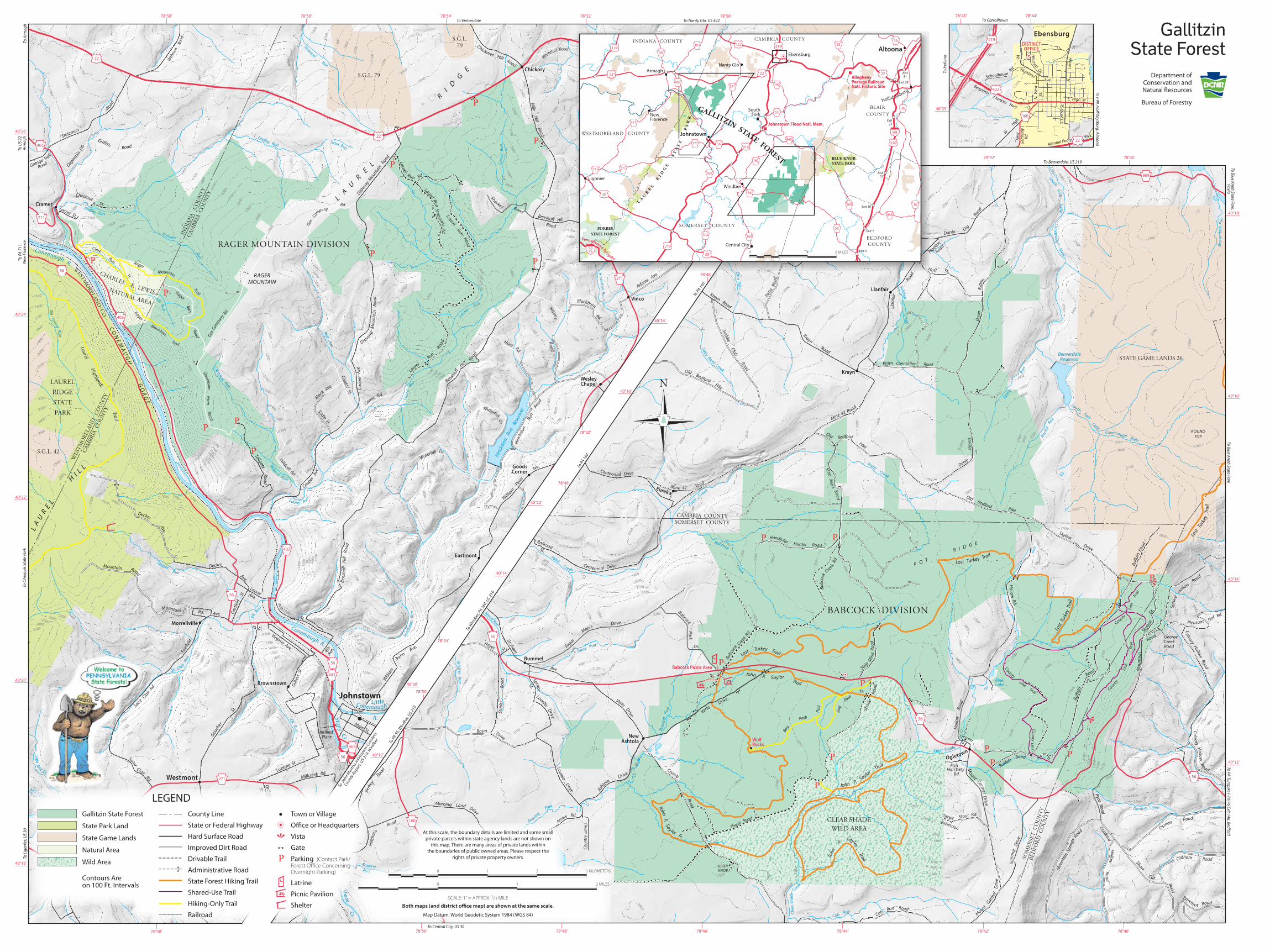
Gallitzin State Forest
State Park Land
State Game Lands
Natural Area
Wild Area
Contours Areon 100 Ft. Intervals
LEGENDCounty Line
State or Federal Highway
Hard Surface Road
Improved Dirt Road
Drivable Trail
Administrative Road
State Forest Hiking Trail
Shared-Use Trail
Hiking-Only Trail
Railroad
Town or Village
Office or Headquarters
Vista
Gate
Parking (Contact Park/Forest O�ce ConcerningOvernight Parking)
Latrine
Picnic Pavilion
Shelter
GallitzinState Forest
Department ofConservation andNatural Resources
Bureau of Forestry
Recommended