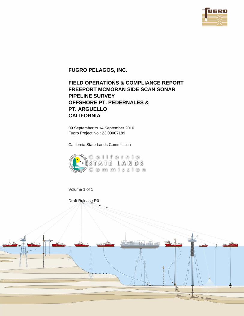
FUGRO PELAGOS, INC.
FIELD OPERATIONS & COMPLIANCE REPORT
FREEPORT MCMORAN SIDE SCAN SONAR
PIPELINE SURVEY
OFFSHORE PT. PEDERNALES &
PT. ARGUELLO
CALIFORNIA
09 September to 14 September 2016
Fugro Project No.: 23.00007189
California State Lands Commission
Volume 1 of 1
Draft Release R0
FUGRO PELAGOS, INC.
Prepared for: California State Lands Commission
100 Howe Ave. Suite 100-South
Sacramento, CA 95825-8202
R0 Draft BV CP CP 10/07/2016
Issue Report Status Prepared Checked Approved Date
FIELD OPERATIONS & COMPLIANCE REPORT
FREEPORT MCMORAN SIDE SCAN SONAR
PIPELINE SURVEY
OFFSHORE PT. PEDERNALES &
PT. ARGUELLO
CALIFORNIA
09 September to 14 September 2016
Fugro Project No.: 23.00007189
Volume 1 of 1
CALIFORNIA STATE LANDS COMMISSION
FIELD OPERATIONS AND COMPLIANCE REPORT
Fugro Document No. 23.00007189_CSLC_Report R0 Page i of i
CONTENTS
1. SURVEY INFORMATION 1
1.1 DESCRIPTION OF THE WORK PERFORMED 1
1.2 DATA COLLECTION DATES, TIMES, WEATHER AND SEA STATE DURING OPERATIONS 1
1.3 CHART OF SURVEY AREA 1
1.4 SPATIAL INFORMATION RELATED TO SURVEY TRACKLINES 1
1.5 NATURE AND LOCATION OF ENVORNMENTAL HAZARDS ENCOUNTERED 1
1.6 ACCIDENT, INJURY, DAMAGE TO OR LOSS OF PROPERTY 2
1.7 OTHER INFORMATION RELATIVE TO THE PERMITTED ACTIVITIES 2
2. BIOLOGICAL INFORMATION 3
APPENDICES
A. MARINE FIELD MONITORING REPORT AND SURVEY TRACKPLOT
B. CSLC MITIGATION MONITORING PROGRAM EXHIBIT H
CALIFORNIA STATE LANDS COMMISSION
FIELD OPERATIONS AND COMPLIANCE REPORT
Fugro Document No. 23.00007189_CSLC_Report R0 Page 1 of 9
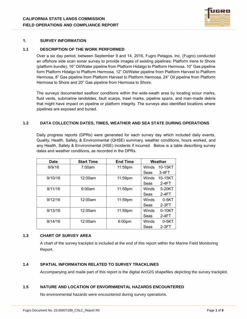
1. SURVEY INFORMATION
1.1 DESCRIPTION OF THE WORK PERFORMED
Over a six day period, between September 9 and 14, 2016, Fugro Pelagos, Inc. (Fugro) conducted
an offshore side scan sonar survey to provide images of existing pipelines: Platform Irene to Shore
(platform bundle), 16” Oil/Water pipeline from Platform Hidalgo to Platform Hermosa, 10” Gas pipeline
form Platform Hidalgo to Platform Hermosa, 12” Oil/Water pipeline from Platform Harvest to Platform
Hermosa, 8” Gas pipeline from Platform Harvest to Platform Hermosa, 24” Oil pipeline from Platform
Hermosa to Shore and 20” Gas pipeline from Hermosa to Shore.
The surveys documented seafloor conditions within the wide-swath area by locating scour marks,
fluid vents, submarine landslides, fault scarps, trawl marks, pipeline spans, and man-made debris
that might have impact on pipeline or platform integrity. The surveys also identified locations where
pipelines are exposed and buried.
1.2 DATA COLLECTION DATES, TIMES, WEATHER AND SEA STATE DURING OPERATIONS
Daily progress reports (DPRs) were generated for each survey day which included daily events,
Quality, Health, Safety, & Environmental (QHSE) summary, weather conditions, hours worked, and
any Health, Safety & Environmental (HSE) incidents if incurred. Below is a table describing survey
dates and weather conditions, as recorded in the DPRs.
Date Start Time End Time Weather
9/9/16 7:00am 11:59pm Winds 10-15KT
Seas 3-4FT
9/10/16 12:00am 11:59pm Winds 10-15KT
Seas 2-4FT
9/11/16 6:00am 11:59pm Winds 5-20KT
Seas 2-4FT
9/12/16 12:00am 11:59pm Winds 0-5KT
Seas 2-3FT
9/13/16 12:00am 11:59pm Winds 0-10KT
Seas 2-4FT
9/14/16 12:00am 6:00pm Winds 0-5KT
Seas 2-3FT
1.3 CHART OF SURVEY AREA
A chart of the survey trackplot is included at the end of this report within the Marine Field Monitoring
Report.
1.4 SPATIAL INFORMATION RELATED TO SURVEY TRACKLINES
Accompanying and made part of this report is the digital ArcGIS shapefiles depicting the survey trackplot.
1.5 NATURE AND LOCATION OF ENVORNMENTAL HAZARDS ENCOUNTERED
No environmental hazards were encountered during survey operations.
CALIFORNIA STATE LANDS COMMISSION
FIELD OPERATIONS AND COMPLIANCE REPORT
Fugro Document No. 23.00007189_CSLC_Report R0 Page 2 of 9
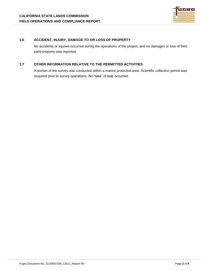
1.6 ACCIDENT, INJURY, DAMAGE TO OR LOSS OF PROPERTY
No accidents or injuries occurred during the operations of the project, and no damages or loss of third
party property was reported.
1.7 OTHER INFORMATION RELATIVE TO THE PERMITTED ACTIVITIES
A portion of the survey was conducted within a marine protected area. Scientific collection permit was
acquired prior to survey operations. No “take” of kelp occurred.
CALIFORNIA STATE LANDS COMMISSION
FIELD OPERATIONS AND COMPLIANCE REPORT
Fugro Document No. 23.00007189_CSLC_Report R0 Page 3 of 9
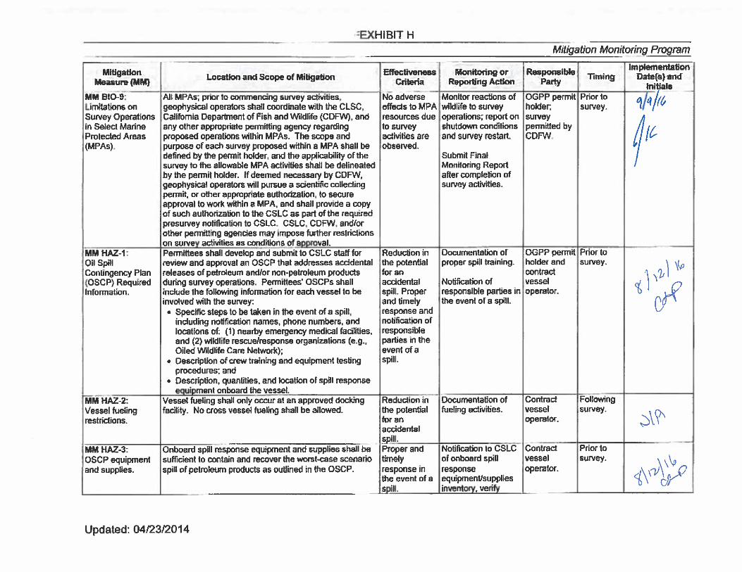
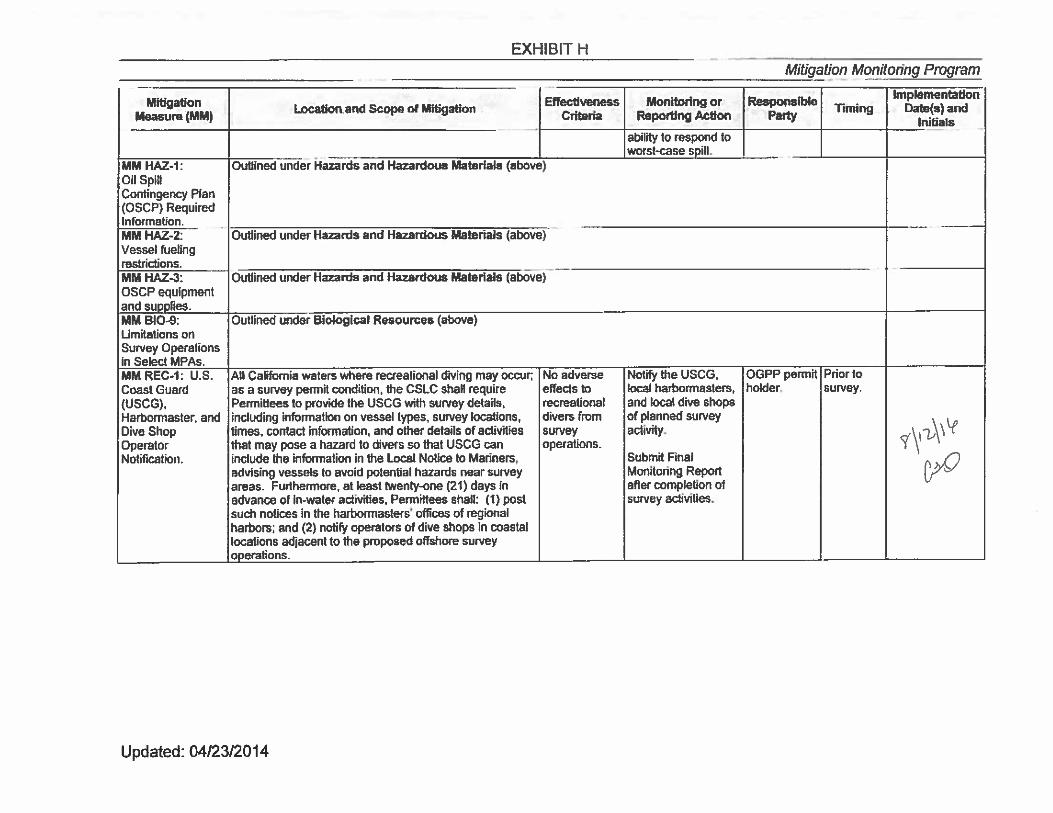
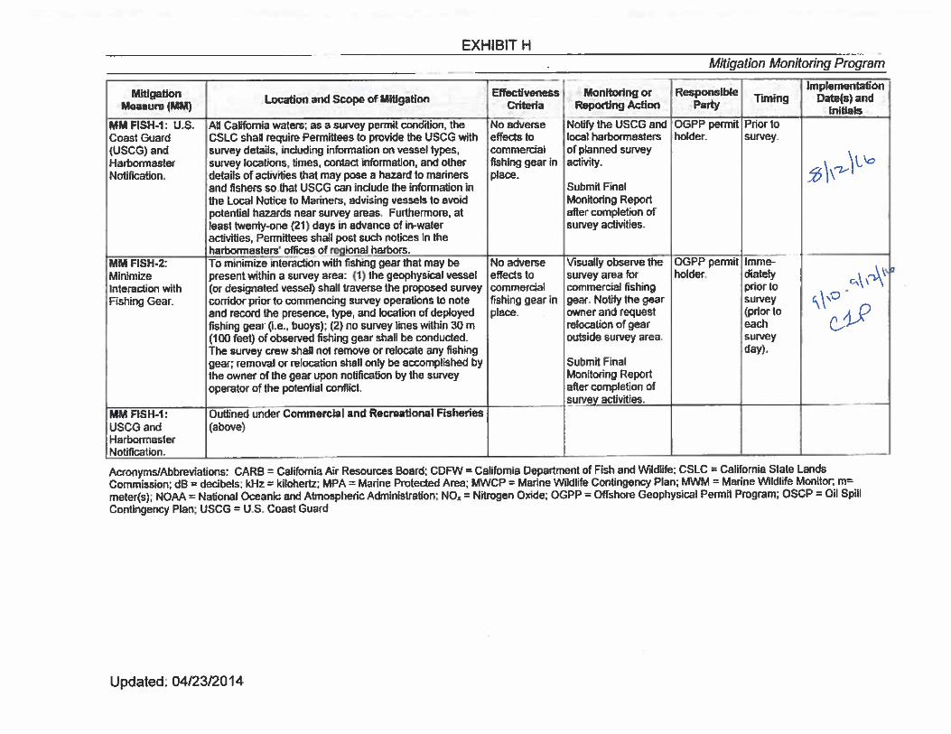
2. BIOLOGICAL INFORMATION
Because the project included surveys within California State Lands Commission (CSLC) jurisdiction,
using geophysical equipment operated at a frequency above 200 kHz, these surveys were conducted
during daylight hours only and two marine mammal observers were onboard. A copy of the final
Marine Wildlife Monitoring Report can be found in Appendix A. In accordance with CSLC regulations,
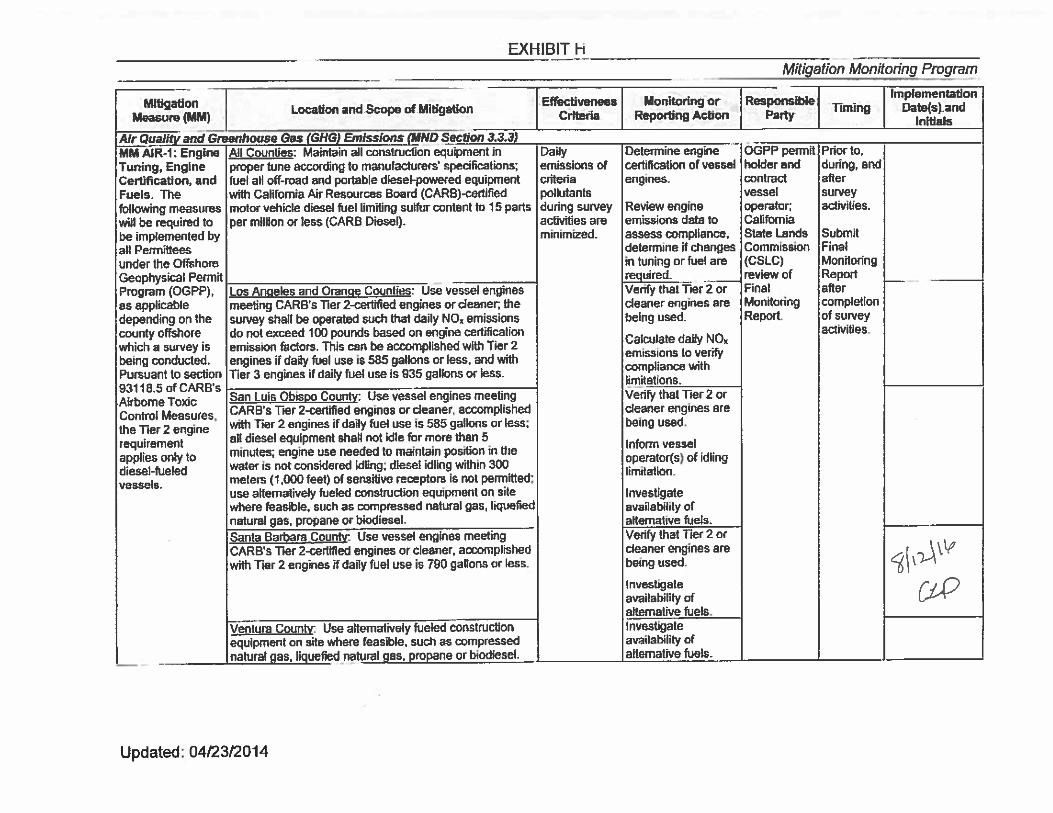
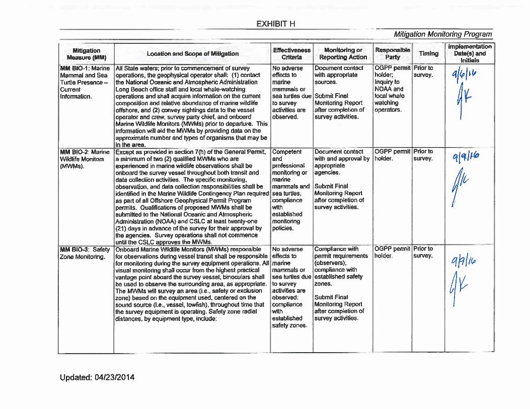
a completed copy of Exhibit H taken from Fugro Geophysical Permit PRC 8391.9 has been completed
with acknowledgements and included in Appendix B.
.
CALIFORNIA STATE LANDS COMMISSION
FIELD OPERATIONS AND COMPLIANCE REPORT
Fugro Document No. 23.00007189_CSLC_Report R0 Appendices
APPENDICES
A. MARINE FIELD MONITORING REPORT AND SURVEY TRACKPLOT
B. CSLC MITIGATION MONITORING PROGRAM EXHIBIT H
CALIFORNIA STATE LANDS COMMISSION
FIELD OPERATIONS AND COMPLIANCE REPORT
Fugro Document No. 23.00007189_CSLC_Report R0 Appendix A
A. MARINE FIELD MONITORING REPORT AND SURVEY TRACKPLOT
MARINE WILDLIFE MONITORING
REPORT
FREEPORT MCMORAN OIL & GAS PIPELINES SIDE
SCAN SONAR SURVEY
SANTA MARIA BASIN, CALIFORNIA
Project No. 1602-2511
Prepared for:
Fugro Pelagos, Inc.
4820 McGrath St., Suite 100
Ventura, California 93003
Prepared by:
Padre Associates, Inc.
369 Pacific Street
San Luis Obispo, California 93401
OCTOBER 2016
Fugro Pelagos, Inc. Marine Wildlife Monitoring Report Project No. 1602-2511
- i -
TABLE OF CONTENTS
1.0 INTRODUCTION ................................................................................................................ 1-1
1.1 PROJECT ACTIVITIES .................................................................................................. 1-1
2.0 REGULATORY SETTING .................................................................................................. 2-1
3.0 METHODS .......................................................................................................................... 3-1
3.1 PERSONNEL ................................................................................................................. 3-1
3.2 FISHING GEAR CLEARANCE ...................................................................................... 3-1
3.3 MONITORING METHODS ............................................................................................. 3-1
3.3.1 Vessel Transit ......................................................................................................... 3-1
3.3.2 Survey Monitoring ................................................................................................... 3-1
3.4 PINNIPED HAUL-OUTS ................................................................................................ 3-2
3.5 MARINE PROTECTED AREAS ..................................................................................... 3-2
4.0 RESULTS ........................................................................................................................... 4-1
4.1 SPECIES OBSERVED ................................................................................................... 4-1
4.2 AVOIDANCE ACTIONS ................................................................................................. 4-1
4.3 MARINE PROTECTED AREAS ..................................................................................... 4-1
4.4 FISHING GEAR ............................................................................................................. 4-2
5.0 CONCLUSION .................................................................................................................... 5-1
LIST OF FIGURES
Figure 1-1. Platform Irene to Shore Survey Area ........................................................... 1-2
Figure 1-2. Platform Hermosa to Platforms Hidalgo and Harvest and to Shore ............ 1-3
Figure 3-1. Marine Protected Area ................................................................................. 3-3
LIST OF TABLES
Table 2-1. OGPP Marine Wildlife Mitigation Measures ................................................. 2-2
Table 4-1. Observed Marine Wildlife Species ............................................................... 4-1
APPENDICES
Appendix A – Daily Marine Wildlife Observation Table
Fugro Pelagos, Inc. Marine Wildlife Monitoring Report Project No. 1602-2511
- 1-1 -
1.0 INTRODUCTION
This Marine Wildlife Monitoring Report (Report) has been prepared for Fugro Pelagos,
Inc. (Fugro) to document the permit compliance and associated observations of marine mammals
and turtles (marine wildlife) during a side scan sonar survey (Project) within the Santa Maria
Basin, California. The monitoring methods and avoidance measures detailed in this Report were
implemented in accordance with the requirements in the existing Low-Energy Offshore
Geophysical Permit PRC 8391.9 issued by the California State Lands Commission (CSLC).
Monitoring and avoidance measures were implemented during the Project to minimize
adverse impacts to marine wildlife within the Project area. This Report summarizes the results of
the monitoring and measures implemented during the Project to reduce or eliminate potential
impacts to marine wildlife.
1.1 PROJECT ACTIVITIES
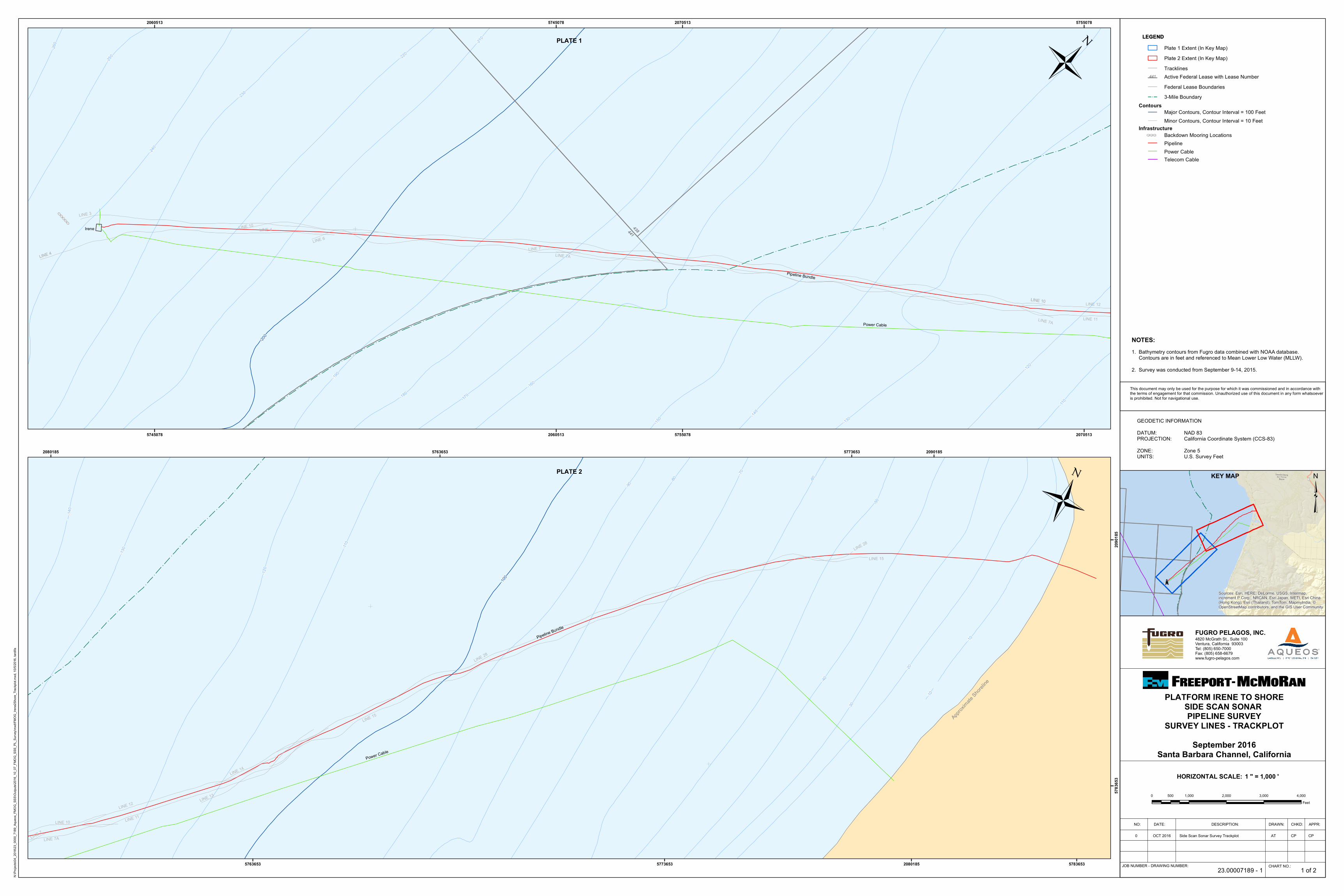
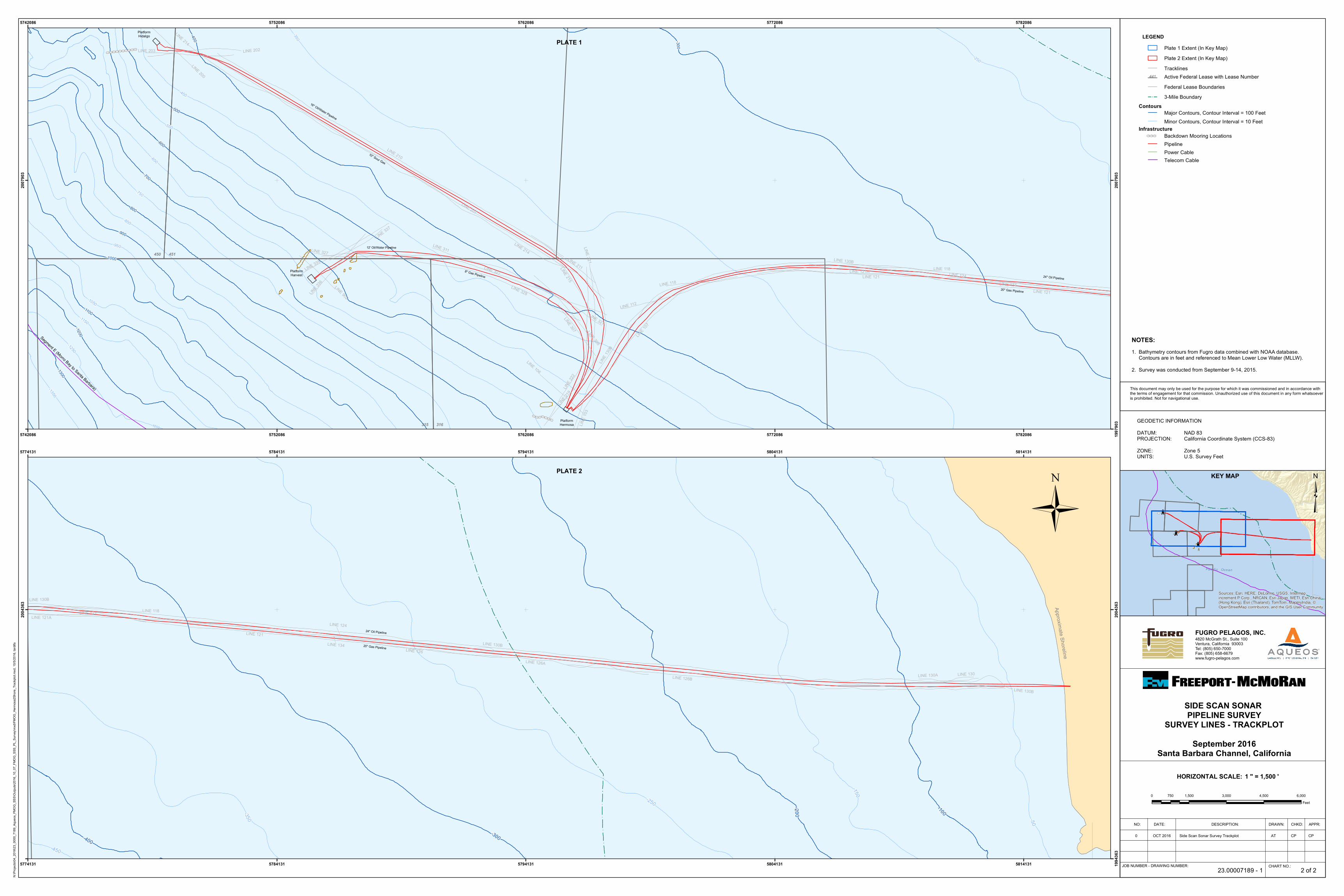
The survey was conducted along Freeport McMoran Oil & Gas (FMOG) Pipelines located
in the Santa Maria Basin (red lines) shown in Figures 1-1 and 1-2, which include:
Platform Irene to Shore
Platform Hermosa to Platforms Hidalgo and Harvest and to Shore
The survey utilized side scan sonar to inspect existing pipelines within the two survey
regions (Figures 1-1, and 1-2). The survey was conducted from the survey vessel DSV Clean Ocean, owned and operated by Aqueos Corporation. Portions of the survey area were located
within State waters out to the three nautical mile line. The survey was conducted from September
9 through September 14, 2016. The acoustic equipment used during the survey was an Edgetech
4200 which was operated within a frequency range of 300 to 600 kilohertz (kHz).
Approxim
ate Shor
eline
-110
LINE 28
LINE 15
-80 -60
-50
-90
-20
-30
-60
-70
-50
-40
-80
-120
-10
-130
-140
-10
-100
LINE 15
LINE 28
LINE 12
LINE 11
LINE 14
LINE 13
LINE 7A
LINE 10
LINE 7
Pipeline Bundle
Power Cable
5763653
5763653
5773653
5773653 5783653
5783
653
2080185
2080185
2090185
2090
185
Õ̀#!
Sources: Esri, HERE, DeLorme, USGS, Intermap,increment P Corp., NRCAN, Esri Japan, METI, Esri China(Hong Kong), Esri (Thailand), TomTom, MapmyIndia, ©OpenStreetMap contributors, and the GIS User Community
³KEY MAP
This document may only be used for the purpose for which it was commissioned and in accordance with the terms of engagement for that commission. Unauthorized use of this document in any form whatsoeveris prohibited. Not for navigational use.
CHART NO.:JOB NUMBER - DRAWING NUMBER:
NO: DATE: DESCRIPTION: DRAWN: CHKD: APPR:
23.00007189 - 1
Side Scan Sonar Survey Trackplot AT CPOCT 20160
NOTES:
CP
HORIZONTAL SCALE:
Õ̀Õ̀Õ̀Õ̀Õ̀
-240
-200
-100
LINE 10
LINE 12
-250
-110
-120
-150
-180-17
0-160
-190
-140
-220
-130
-210
-240
-120
-230
-110
-250
-90
-110
-120
LINE 10
LINE 7A
LINE 11
LINE 7
LINE 3
LINE 4
LINE 6
LINE 12
LINE 13
LINE 10
LINE 4
LINE 12
LINE 13
441438
-260
Power Cable
Pipeline Bundle
Irene LINE 4
LINE 7A
5745078
5745078
5755078
5755078
2060513
2060513
2070513
2070513
0 1,000 2,000 3,000 4,000500Feet
Ü
4820 McGrath St., Suite 100Ventura, California 93003 Tel: (805) 650-7000Fax: (805) 658-6679www.fugro-pelagos.com
FUGRO PELAGOS, INC.
GEODETIC INFORMATIONDATUM:PROJECTION:ZONE:UNITS:
NAD 83California Coordinate System (CCS-83)Zone 5U.S. Survey Feet
1 " = 1,000 '
LEGEND
PLATFORM IRENE TO SHORESIDE SCAN SONAR PIPELINE SURVEY
SURVEY LINES - TRACKPLOTSeptember 2016
Santa Barbara Channel, California
Minor Contours, Contour Interval = 10 FeetMajor Contours, Contour Interval = 100 Feet
Backdown Mooring LocationsÕ̀Õ̀Õ̀
Infrastructure
Contours
Telecom CablePower CablePipeline
1. Bathymetry contours from Fugro data combined with NOAA database. Contours are in feet and referenced to Mean Lower Low Water (MLLW).2. Survey was conducted from September 9-14, 2015.
Ü
1 of 2
LEGEND
Plate 2 Extent (In Key Map)
3-Mile Boundary
Active Federal Lease with Lease Number441
Federal Lease Boundaries
Plate 1 Extent (In Key Map)
Tracklines
PLATE 2
PLATE 1
N:\Pr
ojects
\04_2
016\2
3_00
00_7
189_
Aque
os_F
MOG_
SSS\O
utputs
\2016
_10_
07_F
MOG_
SSS_
PL_S
urvey
\mxd
\FMOG
_Iren
e2Sh
ore_T
rackp
lot.m
xd, 1
0/5/20
16, ta
rdifa
Õ̀
Õ̀
#!
#!
#!
Sources: Esri, HERE, DeLorme, USGS, Intermap,increment P Corp., NRCAN, Esri Japan, METI, Esri China(Hong Kong), Esri (Thailand), TomTom, MapmyIndia, ©OpenStreetMap contributors, and the GIS User Community
³KEY MAP
This document may only be used for the purpose for which it was commissioned and in accordance with the terms of engagement for that commission. Unauthorized use of this document in any form whatsoeveris prohibited. Not for navigational use.
CHART NO.:JOB NUMBER - DRAWING NUMBER:
NO: DATE: DESCRIPTION: DRAWN: CHKD: APPR:
23.00007189 - 1
Side Scan Sonar Survey Trackplot AT CPOCT 20160
NOTES:
CP
HORIZONTAL SCALE:
Approximate Shoreline
LINE 121 LINE 118
LINE 134
LINE 130B
LINE 126B
24" Oil Pipeline
24" Oil Pipeline
20" Gas Pipeline
-150
-100
-50
-200
-250
-300
-350
-400-450
LINE 130B
LINE 121
LINE 124
LINE 130B
LINE 126
LINE 130
LINE 121A
LINE 126A
LINE 130A
5774131
5774131
5784131
5784131
5794131
5794131
5804131
5804131
5814131
5814131 1994
363
2004
363
2004
363
0 1,500 3,000 4,500 6,000750Feet
Ü
4820 McGrath St., Suite 100Ventura, California 93003 Tel: (805) 650-7000Fax: (805) 658-6679www.fugro-pelagos.com
FUGRO PELAGOS, INC.
GEODETIC INFORMATIONDATUM:PROJECTION:ZONE:UNITS:
NAD 83California Coordinate System (CCS-83)Zone 5U.S. Survey Feet
1 " = 1,500 '
LEGEND
SIDE SCAN SONAR PIPELINE SURVEY
SURVEY LINES - TRACKPLOTSeptember 2016
Santa Barbara Channel, California
Minor Contours, Contour Interval = 10 FeetMajor Contours, Contour Interval = 100 Feet
Backdown Mooring LocationsÕ̀Õ̀Õ̀
Infrastructure
Contours
Plate 2 Extent (In Key Map)
Telecom Cable
3-Mile Boundary
Active Federal Lease with Lease Number
Power CablePipeline
441
Federal Lease Boundaries
1. Bathymetry contours from Fugro data combined with NOAA database. Contours are in feet and referenced to Mean Lower Low Water (MLLW).2. Survey was conducted from September 9-14, 2015.
Ü
2 of 2
Plate 1 Extent (In Key Map)
Tracklines
Õ̀Õ̀Õ̀Õ̀Õ̀Õ̀Õ̀
Õ̀Õ̀Õ̀Õ̀Õ̀Õ̀Õ̀Õ̀Õ̀Õ̀
451450
316315
LINE 214
LINE 1
30B
LINE 121LINE 118LINE 327
LINE 327
PlatformHarvest
PlatformHidalgo
PlatformHermosa-1250
10" Sour Gas
24" Oil Pipeline
20" Gas Pipeline
16" Oil/Water Pipeline
8" Gas Pipeline
12' Oil/Water Pipeline
Segment E (Morro Bay to Santa Barbara)
-1100
-1350-1300
-1250-1200
-250
-1000
-1050
-350
-400
-450
-600
-650
-700
-750
-550
-500
-1150
-800-850
-900
-950
-300
LINE 214LINE 130B
LINE 207
LINE 210
LINE 121
LINE 327
LINE 124LINE 118 LINE 134LINE 328
LINE 311
LINE 21
9
LINE 1
03
LINE 2
22
LINE 112
LINE 121A
LINE 221
LINE 335
LINE 202
LINE 10
7
LINE 203
LINE 215
LINE 308
LINE 33
6
LINE 211
LINE 307
LINE 337
LINE 106
LINE 200
LINE 902
5742086
5742086
5752086
5752086
5762086
5762086
5772086
5772086
5782086
5782086 1997
903
2007
903
2007
903
PLATE 1
N:\Pr
ojects
\04_2
016\2
3_00
00_7
189_
Aque
os_F
MOG_
SSS\O
utputs
\2016
_10_
07_F
MOG_
SSS_
PL_S
urvey
\mxd
\FMOG
_Herm
osa2
Shore
_Trac
kplot
.mxd
, 10/5
/2016
, tardi
fa
PLATE 2
Fugro Pelagos, Inc. Marine Wildlife Monitoring Report Project No. 1602-2511
- 2-1 -
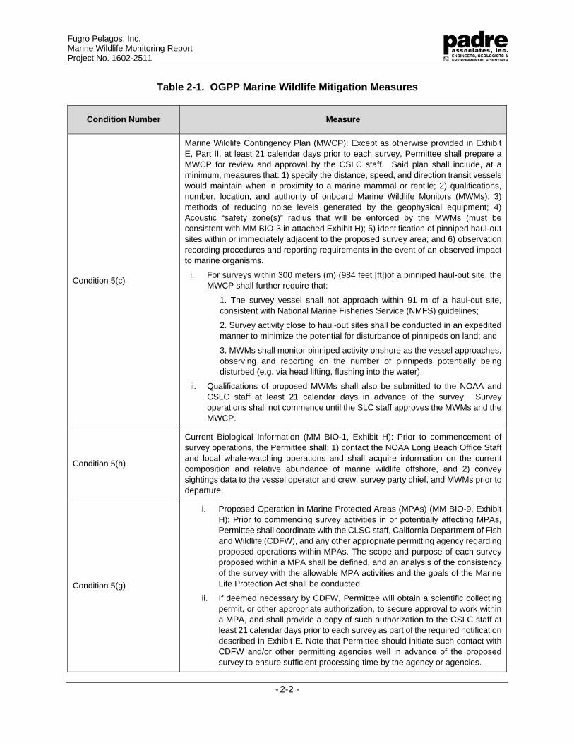
2.0 REGULATORY SETTING
The CSLC Offshore Geophysical Permit Program (OGPP) requires individual surveying
entities to obtain an OGPP non-exclusive permit to perform low-energy geophysical surveys of
the ocean bottom and marine environment. Under the OGPP, operators are permitted to conduct
surveys using specific types of geophysical equipment subject to permit terms and conditions
developed to minimize impacts to marine wildlife and the coastal environment. In August 2013,
the CSLC identified potential impacts to marine wildlife from acoustical survey equipment within
a Mitigated Negative Declaration (MND), and identified mitigation measures that would reduce or
avoid those impacts to a point where no significant impacts would occur. This Report details the
compliance with the applicable OGPP permit mitigation measures as outlined in Table 2-1.
In addition, The United States Marine Mammal Protection Act (MMPA) of 1972, amended
1994, protects all marine mammals, including cetaceans (whales, dolphins, and porpoises),
pinnipeds (seals and sea lions), sirenians (manatees and dugongs), sea otters, and polar bears
within the waters of the United States. Specifically, the MMPA prohibits the intentional killing or
harassment of these marine mammals; however, incidental harassment, with authorization from
the appropriate Federal agency, may be permitted. National Oceanic and Atmospheric
Administration (NOAA) Fisheries is responsible for enforcing the MMPA.
Special status species are protected by the Federal Endangered Species Act (ESA) of
1973 (Section 9 and implementing regulations 50 CFR Part 17). The Federal ESA makes it
unlawful to harass, harm, pursue, hunt, shoot, wound, kill, trap, capture, or collect an endangered
species, or to attempt to engage in any such conduct. Anyone violating the provisions of the
Federal ESA and regulations is subject to a fine and imprisonment. An “endangered species” is
any species which the Secretaries of the Department of the Interior and/or the Department of
Commerce determine is in danger of extinction throughout all or a portion of its range. A
“threatened species” is any species which the Secretaries determine is likely to become an
endangered species within the foreseeable future throughout all or a significant portion of its
range. The United States Fish and Wildlife Service (USFWS) and NOAA Fisheries are
responsible for implementation of the Federal ESA.
Fugro Pelagos, Inc. Marine Wildlife Monitoring Report Project No. 1602-2511
- 2-2 -
Table 2-1. OGPP Marine Wildlife Mitigation Measures
Condition Number Measure
Condition 5(c)
Marine Wildlife Contingency Plan (MWCP): Except as otherwise provided in Exhibit
E, Part II, at least 21 calendar days prior to each survey, Permittee shall prepare a
MWCP for review and approval by the CSLC staff. Said plan shall include, at a
minimum, measures that: 1) specify the distance, speed, and direction transit vessels
would maintain when in proximity to a marine mammal or reptile; 2) qualifications,
number, location, and authority of onboard Marine Wildlife Monitors (MWMs); 3)
methods of reducing noise levels generated by the geophysical equipment; 4)
Acoustic “safety zone(s)” radius that will be enforced by the MWMs (must be
consistent with MM BIO-3 in attached Exhibit H); 5) identification of pinniped haul-out
sites within or immediately adjacent to the proposed survey area; and 6) observation
recording procedures and reporting requirements in the event of an observed impact
to marine organisms.
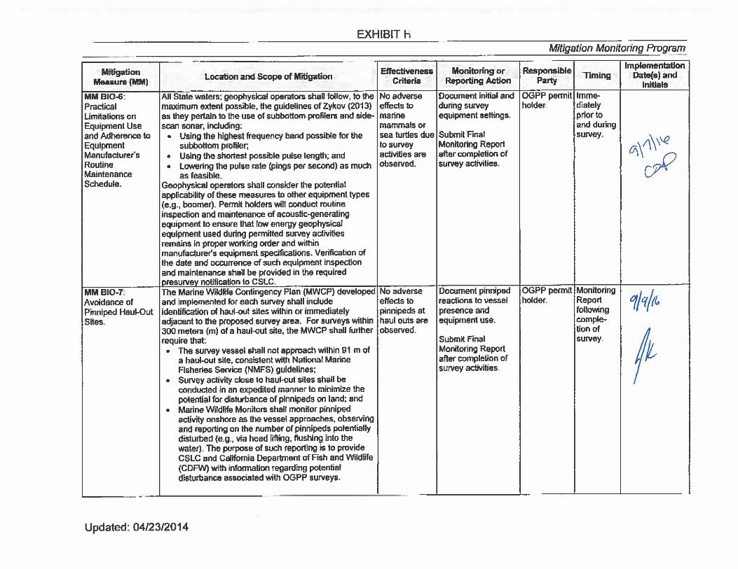
i. For surveys within 300 meters (m) (984 feet [ft])of a pinniped haul-out site, the
MWCP shall further require that:
1. The survey vessel shall not approach within 91 m of a haul-out site,
consistent with National Marine Fisheries Service (NMFS) guidelines;
2. Survey activity close to haul-out sites shall be conducted in an expedited
manner to minimize the potential for disturbance of pinnipeds on land; and
3. MWMs shall monitor pinniped activity onshore as the vessel approaches,
observing and reporting on the number of pinnipeds potentially being
disturbed (e.g. via head lifting, flushing into the water).
ii. Qualifications of proposed MWMs shall also be submitted to the NOAA and
CSLC staff at least 21 calendar days in advance of the survey. Survey
operations shall not commence until the SLC staff approves the MWMs and the
MWCP.
Condition 5(h)
Current Biological Information (MM BIO-1, Exhibit H): Prior to commencement of
survey operations, the Permittee shall; 1) contact the NOAA Long Beach Office Staff
and local whale-watching operations and shall acquire information on the current
composition and relative abundance of marine wildlife offshore, and 2) convey
sightings data to the vessel operator and crew, survey party chief, and MWMs prior to
departure.
Condition 5(g)
i. Proposed Operation in Marine Protected Areas (MPAs) (MM BIO-9, Exhibit
H): Prior to commencing survey activities in or potentially affecting MPAs,
Permittee shall coordinate with the CLSC staff, California Department of Fish
and Wildlife (CDFW), and any other appropriate permitting agency regarding
proposed operations within MPAs. The scope and purpose of each survey
proposed within a MPA shall be defined, and an analysis of the consistency
of the survey with the allowable MPA activities and the goals of the Marine
Life Protection Act shall be conducted.
ii. If deemed necessary by CDFW, Permittee will obtain a scientific collecting
permit, or other appropriate authorization, to secure approval to work within
a MPA, and shall provide a copy of such authorization to the CSLC staff at
least 21 calendar days prior to each survey as part of the required notification
described in Exhibit E. Note that Permittee should initiate such contact with
CDFW and/or other permitting agencies well in advance of the proposed
survey to ensure sufficient processing time by the agency or agencies.
Fugro Pelagos, Inc. Marine Wildlife Monitoring Report Project No. 1602-2511
- 2-3 -
Condition Number Measure
iii. CSLC staff, CDFW, and/or other permitting agencies may impose further
restrictions on survey activities within MPAs generally or any specific MPA
as conditions of approval
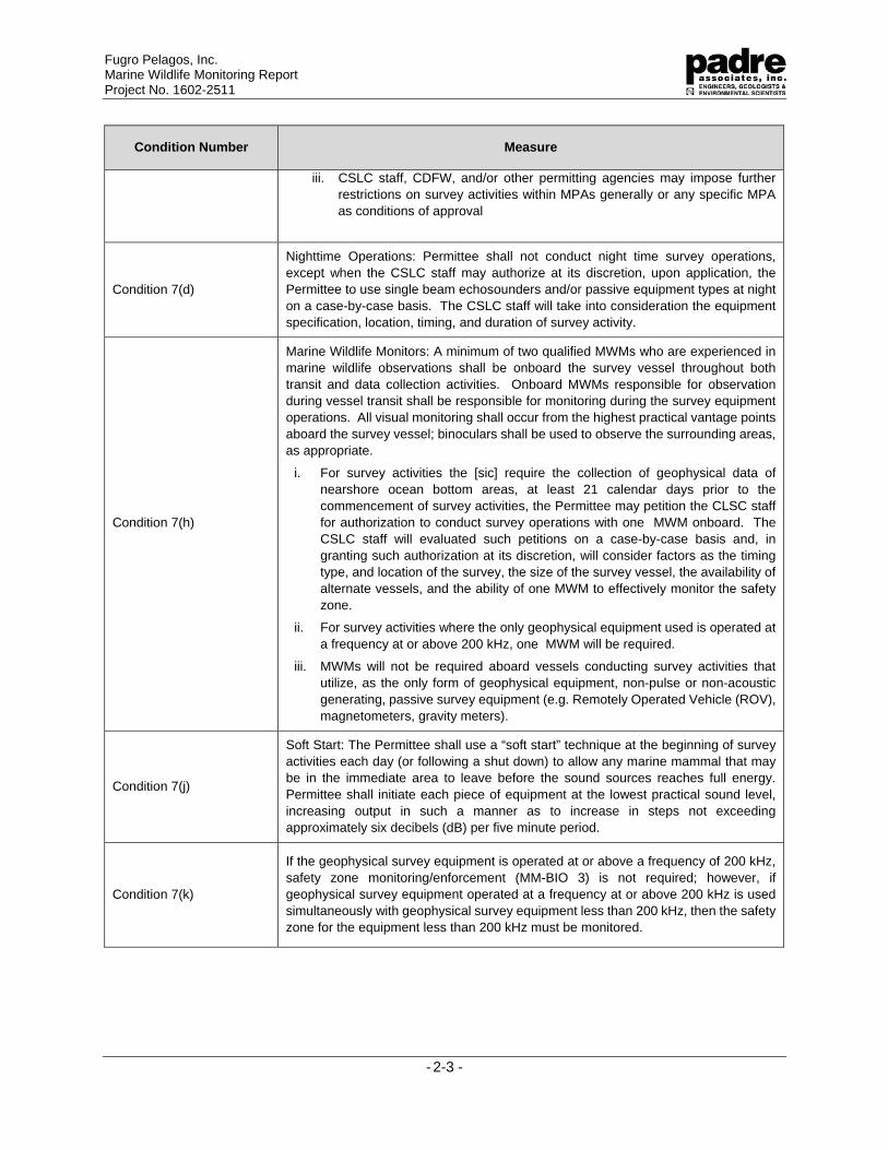
Condition 7(d)
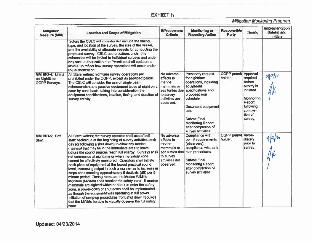
Nighttime Operations: Permittee shall not conduct night time survey operations,
except when the CSLC staff may authorize at its discretion, upon application, the
Permittee to use single beam echosounders and/or passive equipment types at night
on a case-by-case basis. The CSLC staff will take into consideration the equipment
specification, location, timing, and duration of survey activity.
Condition 7(h)
Marine Wildlife Monitors: A minimum of two qualified MWMs who are experienced in
marine wildlife observations shall be onboard the survey vessel throughout both
transit and data collection activities. Onboard MWMs responsible for observation
during vessel transit shall be responsible for monitoring during the survey equipment
operations. All visual monitoring shall occur from the highest practical vantage points
aboard the survey vessel; binoculars shall be used to observe the surrounding areas,
as appropriate.
i. For survey activities the [sic] require the collection of geophysical data of
nearshore ocean bottom areas, at least 21 calendar days prior to the
commencement of survey activities, the Permittee may petition the CLSC staff
for authorization to conduct survey operations with one MWM onboard. The
CSLC staff will evaluated such petitions on a case-by-case basis and, in
granting such authorization at its discretion, will consider factors as the timing
type, and location of the survey, the size of the survey vessel, the availability of
alternate vessels, and the ability of one MWM to effectively monitor the safety
zone.
ii. For survey activities where the only geophysical equipment used is operated at
a frequency at or above 200 kHz, one MWM will be required.
iii. MWMs will not be required aboard vessels conducting survey activities that
utilize, as the only form of geophysical equipment, non-pulse or non-acoustic
generating, passive survey equipment (e.g. Remotely Operated Vehicle (ROV),
magnetometers, gravity meters).
Condition 7(j)
Soft Start: The Permittee shall use a “soft start” technique at the beginning of survey
activities each day (or following a shut down) to allow any marine mammal that may
be in the immediate area to leave before the sound sources reaches full energy.
Permittee shall initiate each piece of equipment at the lowest practical sound level,
increasing output in such a manner as to increase in steps not exceeding
approximately six decibels (dB) per five minute period.
Condition 7(k)
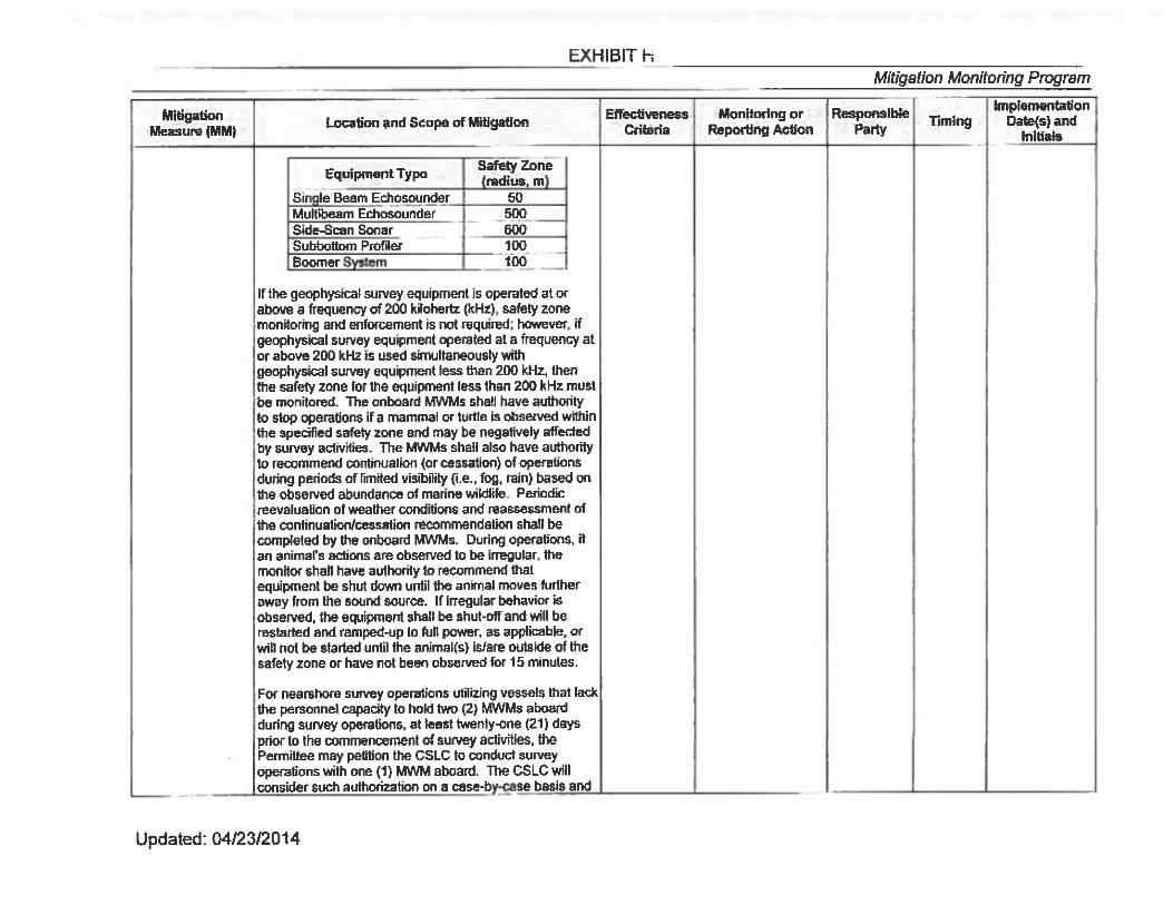
If the geophysical survey equipment is operated at or above a frequency of 200 kHz,
safety zone monitoring/enforcement (MM-BIO 3) is not required; however, if
geophysical survey equipment operated at a frequency at or above 200 kHz is used
simultaneously with geophysical survey equipment less than 200 kHz, then the safety
zone for the equipment less than 200 kHz must be monitored.
Fugro Pelagos, Inc. Marine Wildlife Monitoring Report Project No. 1602-2511
- 2-4 -
Condition Number Measure
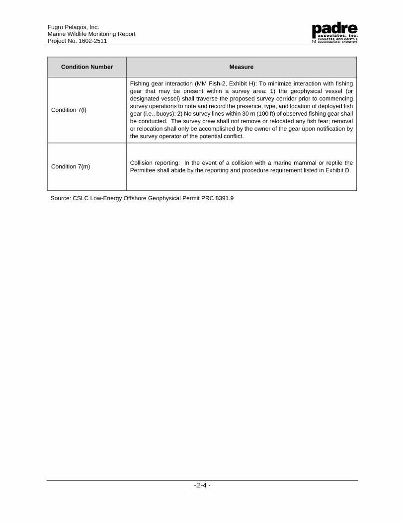
Condition 7(l)
Fishing gear interaction (MM Fish-2, Exhibit H): To minimize interaction with fishing
gear that may be present within a survey area: 1) the geophysical vessel (or
designated vessel) shall traverse the proposed survey corridor prior to commencing
survey operations to note and record the presence, type, and location of deployed fish
gear (i.e., buoys); 2) No survey lines within 30 m (100 ft) of observed fishing gear shall
be conducted. The survey crew shall not remove or relocated any fish fear; removal
or relocation shall only be accomplished by the owner of the gear upon notification by
the survey operator of the potential conflict.
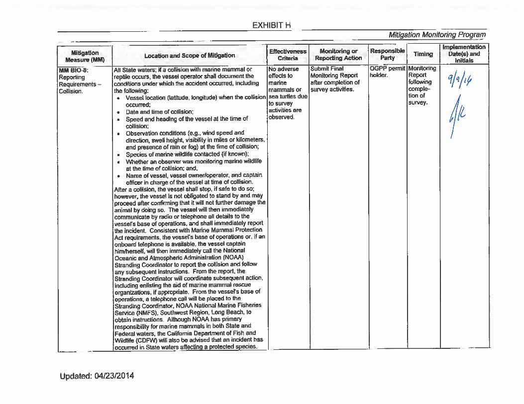
Condition 7(m) Collision reporting: In the event of a collision with a marine mammal or reptile the
Permittee shall abide by the reporting and procedure requirement listed in Exhibit D.
Source: CSLC Low-Energy Offshore Geophysical Permit PRC 8391.9
Fugro Pelagos, Inc. Marine Wildlife Monitoring Report Project No. 1602-2511
- 3-1 -
3.0 METHODS
Three days prior to the initiation of the survey, Padre marine biologists contacted NOAA
Fisheries Long Beach office staff and local whale-watching groups to inquire about the species
and numbers of recently observed marine wildlife near the survey area. During survey operations,
MWMs onboard the survey vessel were responsible for observing wildlife and their behaviors
during transit and data collection operations. Monitoring conditions and avoidance measures
designed to decrease the potential impacts to marine wildlife were implemented as detailed in the
following sections.
3.1 PERSONNEL
The side scan sonar equipment was operated at frequencies greater than 200 kHz;
therefore, only one NOAA-approved MWM was required during survey operations. MWMs
onboard the survey vessel were Jennifer Klaib and Patrick Crooks, with Padre Associates, Inc.
Monitoring was conducted during all side scan sonar operations in State Waters, with monitors
alternating shifts.
3.2 FISHING GEAR CLEARANCE
In accordance with geophysical permit conditions, vessel personnel noted the presence
of commercial fishing gear within the survey area. Survey lines were not completed within 30 (m)
(100 ft) of any observed fishing gear. The onboard MWM aided in the identification and avoidance
of fishing gear during survey operations.
3.3 MONITORING METHODS
Monitoring occurred during Project activities that were within State waters. Fugro notified
the MWM when the survey was entering and exiting State waters.
3.3.1 Vessel Transit
The survey vessel initially transited from Port Hueneme, California, to the survey area.
During Project operations, the survey vessel regularly transited between State and Federal
waters. At the completion of the Project, the vessel transited from the survey area to Port
Hueneme, California.
During vessel transit, there was the potential for encountering marine wildlife, therefore a
MWM was positioned at the highest safe vantage point for a clear view of the ocean within the
vessel’s path. To minimize the chance of collision with, or disturbance of, marine wildlife, the
MWM recommended that the vessel maintain a minimum distance of 91 m (300 ft) from marine
wildlife. If marine wildlife was observed within the path of the transiting vessel, the monitor
reported that observation to the vessel operator, who slowed the vessel and/or changed course
in order to avoid contact.
3.3.2 Survey Monitoring
Prior to the start of data collection, survey operators utilized a “soft start” technique to
allow any marine wildlife that may be in the survey area to leave before the sound source reached
full energy level. MWMs were prepared with the appropriate safety and monitoring equipment to
Fugro Pelagos, Inc. Marine Wildlife Monitoring Report Project No. 1602-2511
- 3-2 -
conduct observations, including Nikon 7 x 50 low light reticulated binoculars for daytime and low
light observations. Survey activities within State waters were conducted during daylight hours
only.
MWM visually scanned the general survey area near the survey vessel for wildlife
whenever survey equipment was operating. Per the OGPP requirements, no safety zone was
required during the side scan sonar sonar survey. When marine wildlife were observed, the MWM
identified the species, counted the number of individual animals present, observed the animals’
behavior, and the animals’ direction/speed of movement. The MWM recorded any distress
behaviors and implemented avoidance actions as discussed above, if necessary.
3.4 PINNIPED HAUL-OUTS
Survey activities did not occur with 300 m (984 ft) of any known pinniped haul-out and/or
rookeries.
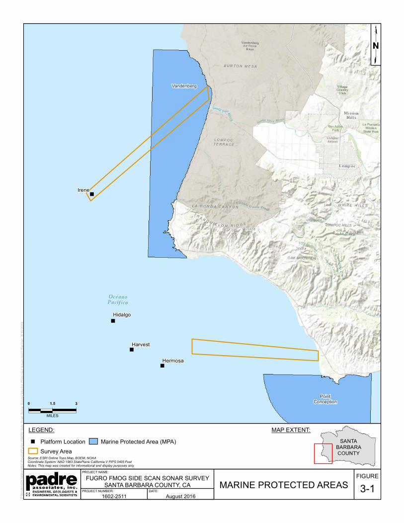
3.5 MARINE PROTECTED AREAS
The survey from Platform Irene to shore occurred within the Vandenberg State Marine
Reserve, a designated MPA (Figure 3-1). Prior to commencing survey activities within the MPA,
Fugro coordinated with CSLC staff and CDFW regarding proposed operations within the
MPA. On August 31, 2016, Fugro received an entity Scientific Collecting Permit (SCP) from
CDFW to conduct survey activities with the MPA. Ms. Klaib was the SCP Principal
Investigator onboard during Project activities. Per the requirements of the SCP, Ms. Klaib noted
any species that may have been impacted by Project activities within the MPA.
")
")
")
")
Harvest
Hermosa
Irene
Hidalgo
Vandenberg
PointConception
MARINE PROTECTED AREAS
Source: ESRI Online Topo Map, BOEM, NOAACoordinate System: NAD 1983 StatePlane California V FIPS 0405 FeetNotes: This map was created for informational and display purposes only.
Z:\Kr
istin\
GIS M
aps\M
ap P
rojec
t\Fug
ro FM
OG Si
de Sc
an So
nar S
urvey
\Mari
ne Pr
otecte
d Area
s.mxd
LBan
nan
8/10/2
016
LEGEND:") Platform Location
Survey AreaMarine Protected Area (MPA)
FIGURE3-1
FUGRO FMOG SIDE SCAN SONAR SURVEYSANTA BARBARA COUNTY, CA
PROJECT NUMBER: DATE:
PROJECT NAME:
0 1.5 3
MILES
SANTABARBARACOUNTY
MAP EXTENT:
1602-2511 August 2016
Fugro Pelagos, Inc. Marine Wildlife Monitoring Report Project No. 1602-2511
- 4-1 -
4.0 RESULTS
All marine wildlife observations are detailed in Appendix A – Daily Marine Wildlife
Observations. The following sections summarize the observations made by MWMs and results
of any avoidance actions requested during the Project.
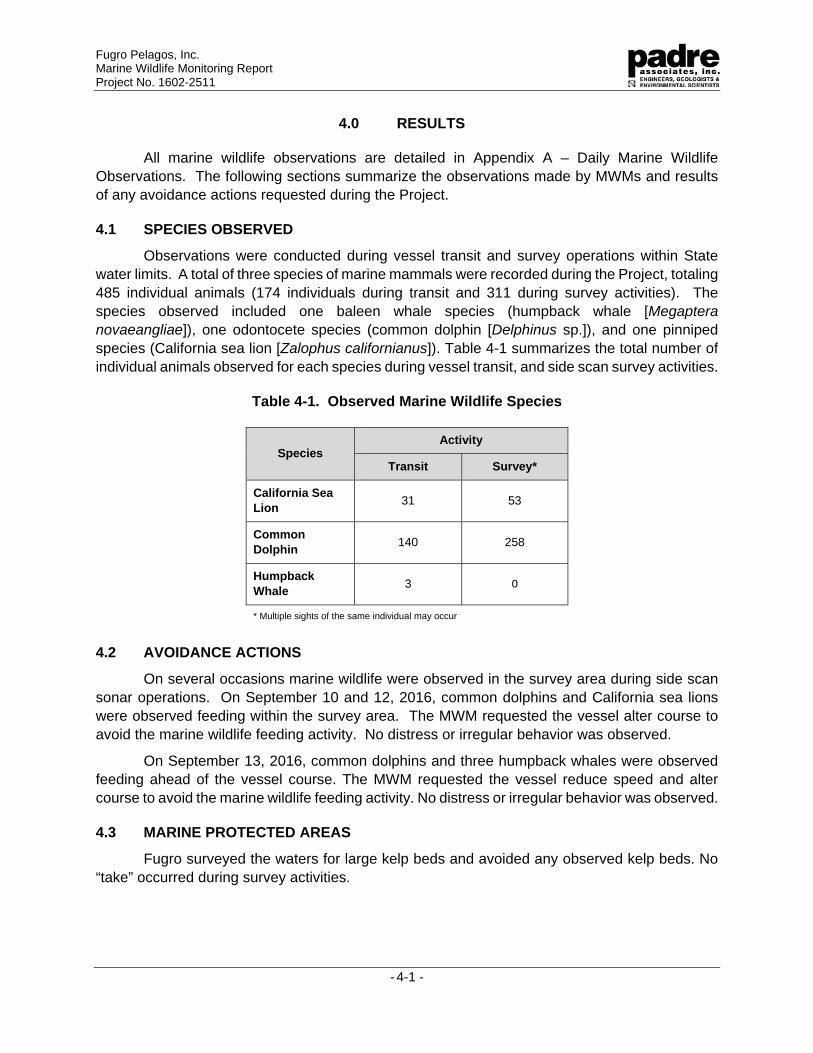
4.1 SPECIES OBSERVED
Observations were conducted during vessel transit and survey operations within State
water limits. A total of three species of marine mammals were recorded during the Project, totaling
485 individual animals (174 individuals during transit and 311 during survey activities). The
species observed included one baleen whale species (humpback whale [Megaptera novaeangliae]), one odontocete species (common dolphin [Delphinus sp.]), and one pinniped
species (California sea lion [Zalophus californianus]). Table 4-1 summarizes the total number of
individual animals observed for each species during vessel transit, and side scan survey activities.
Table 4-1. Observed Marine Wildlife Species
Species Activity
Transit Survey*
California Sea
Lion 31 53
Common
Dolphin 140 258
Humpback
Whale 3 0
* Multiple sights of the same individual may occur
4.2 AVOIDANCE ACTIONS
On several occasions marine wildlife were observed in the survey area during side scan
sonar operations. On September 10 and 12, 2016, common dolphins and California sea lions
were observed feeding within the survey area. The MWM requested the vessel alter course to
avoid the marine wildlife feeding activity. No distress or irregular behavior was observed.
On September 13, 2016, common dolphins and three humpback whales were observed
feeding ahead of the vessel course. The MWM requested the vessel reduce speed and alter
course to avoid the marine wildlife feeding activity. No distress or irregular behavior was observed.
4.3 MARINE PROTECTED AREAS
Fugro surveyed the waters for large kelp beds and avoided any observed kelp beds. No
“take” occurred during survey activities.
Fugro Pelagos, Inc. Marine Wildlife Monitoring Report Project No. 1602-2511
- 4-2 -
4.4 FISHING GEAR
Prior to initiating data collection, a fishing gear clearance was completed within each
survey corridor. No fishing gear was observed with the survey areas.
.
Fugro Pelagos, Inc. Marine Wildlife Monitoring Report Project No. 1602-2511
- 5-1 -
5.0 CONCLUSION
The MWM observed three marine mammal species that were anticipated to occur within
the survey area, and implementation of preemptive avoidance actions helped to minimize the
potential adverse impacts to those marine species. There were three mitigation vessel redirection
and speed reductions that were implemented throughout the Project. No collisions occurred with
marine wildlife and no distress was observed during the course of the survey period. Based on
the observations of the MWM, and the cooperative efforts of the Fugro team and vessel crew, no
negative Project-related effects to the marine wildlife were observed during the survey period.
APPENDIX A
DAILY MARINE WILDLIFE OBSERVATION TABLE
Fugro Pelagos, Inc. - Marine Wildlife Monitoring Report
Appendix A – Daily Marine Wildlife Observation Table
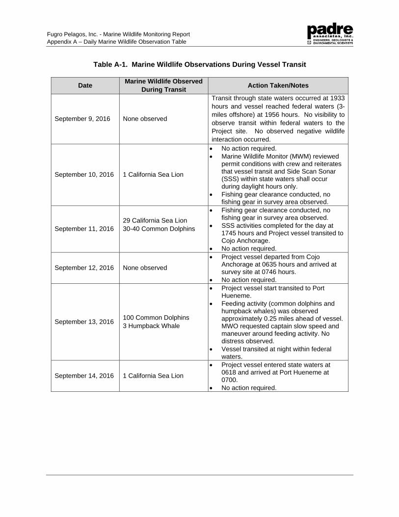
Table A-1. Marine Wildlife Observations During Vessel Transit
Date Marine Wildlife Observed
During Transit Action Taken/Notes
September 9, 2016 None observed
Transit through state waters occurred at 1933
hours and vessel reached federal waters (3-
miles offshore) at 1956 hours. No visibility to
observe transit within federal waters to the
Project site. No observed negative wildlife
interaction occurred.
September 10, 2016 1 California Sea Lion
No action required.
Marine Wildlife Monitor (MWM) reviewed permit conditions with crew and reiterates that vessel transit and Side Scan Sonar (SSS) within state waters shall occur during daylight hours only.
Fishing gear clearance conducted, no fishing gear in survey area observed.
September 11, 2016
29 California Sea Lion
30-40 Common Dolphins
Fishing gear clearance conducted, no fishing gear in survey area observed.
SSS activities completed for the day at 1745 hours and Project vessel transited to Cojo Anchorage.
No action required.
September 12, 2016 None observed
Project vessel departed from Cojo Anchorage at 0635 hours and arrived at survey site at 0746 hours.
No action required.
September 13, 2016 100 Common Dolphins
3 Humpback Whale
Project vessel start transited to Port Hueneme.
Feeding activity (common dolphins and humpback whales) was observed approximately 0.25 miles ahead of vessel. MWO requested captain slow speed and maneuver around feeding activity. No distress observed.
Vessel transited at night within federal waters.
September 14, 2016 1 California Sea Lion
Project vessel entered state waters at 0618 and arrived at Port Hueneme at 0700.
No action required.
Fugro Pelagos, Inc. - Marine Wildlife Monitoring Report
Appendix A – Daily Marine Wildlife Observation Table
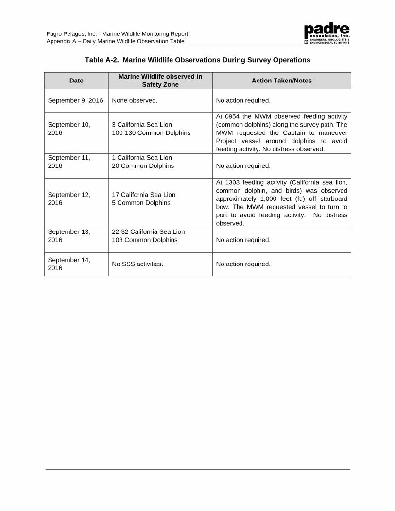
Table A-2. Marine Wildlife Observations During Survey Operations
Date Marine Wildlife observed in
Safety Zone Action Taken/Notes
September 9, 2016 None observed. No action required.
September 10,
2016
3 California Sea Lion
100-130 Common Dolphins
At 0954 the MWM observed feeding activity
(common dolphins) along the survey path. The
MWM requested the Captain to maneuver
Project vessel around dolphins to avoid
feeding activity. No distress observed.
September 11,
2016
1 California Sea Lion
20 Common Dolphins
No action required.
September 12,
2016
17 California Sea Lion
5 Common Dolphins
At 1303 feeding activity (California sea lion,
common dolphin, and birds) was observed
approximately 1,000 feet (ft.) off starboard
bow. The MWM requested vessel to turn to
port to avoid feeding activity. No distress
observed.
September 13,
2016
22-32 California Sea Lion
103 Common Dolphins
No action required.
September 14,
2016 No SSS activities. No action required.
CALIFORNIA STATE LANDS COMMISSION
FIELD OPERATIONS AND COMPLIANCE REPORT
Fugro Document No. 23.00007189_CSLC_Report R0 Appendix B
B. CSLC MITIGATION MONITORING PROGRAM EXHIBIT H
Recommended