Embed Size (px)
Citation preview
FUGRO PELAGOS, INC.
FIELD OPERATIONS & COMPLIANCE REPORT
DCOR, LLC SIDE SCAN SONAR PIPELINE
INSPECTION SURVEY
OFFSHORE LONG BEACH, OXNARD,
CARPINTERIA
CALIFORNIA
15 November to 25 November 2016
Fugro Project No.: 23.00007195
California State Lands Commission
Volume 1 of 1
Draft Release R0
FUGRO PELAGOS, INC.
Prepared for: California State Lands Commission
100 Howe Ave. Suite 100-South
Sacramento, CA 95825-8202
R0 Draft BV CP CP 12/21/2016
Issue Report Status Prepared Checked Approved Date
FIELD OPERATIONS & COMPLIANCE REPORT
DCOR, LLC SIDE SCAN SONAR PIPELINE
INSPECTION SURVEY
OFFSHORE LONG BEACH, OXNARD,
CARPINTERIA
CALIFORNIA
15 November to 25 November 2016
Fugro Project No.: 23.00007195
Volume 1 of 1
CALIFORNIA STATE LANDS COMMISSION
FIELD OPERATIONS AND COMPLIANCE REPORT
Fugro Document No. 23.00007195_CSLC_Report R0 Page i of i
CONTENTS
1. SURVEY INFORMATION 1
1.1 DESCRIPTION OF THE WORK PERFORMED 1
1.2 DATA COLLECTION DATES, TIMES, WEATHER AND SEA STATE DURING OPERATIONS 1
1.3 CHART OF SURVEY AREA 2
1.4 SPATIAL INFORMATION RELATED TO SURVEY TRACKLINES 2
1.5 NATURE AND LOCATION OF ENVORNMENTAL HAZARDS ENCOUNTERED 2
1.6 ACCIDENT, INJURY, DAMAGE TO OR LOSS OF PROPERTY 2
2. BIOLOGICAL INFORMATION 3
APPENDICES
A. MARINE FIELD MONITORING REPORT AND SURVEY TRACKPLOT
B. EXHIBIT H
CALIFORNIA STATE LANDS COMMISSION
FIELD OPERATIONS AND COMPLIANCE REPORT
Fugro Document No. 23.00007195_CSLC_Report R0 Page 1 of 9
1. SURVEY INFORMATION
1.1 DESCRIPTION OF THE WORK PERFORMED
Over a seven-day period, between November 15 and 25, 2016, Fugro Pelagos, Inc. (Fugro) provided
side scan sonar pipeline inspection services for all the pipelines DCOR operates in Southern
California. The purpose of the side scan sonar survey was to acquire seafloor imaging of existing
pipelines and document the seafloor conditions within the wide-swath area by locating scour marks,
fluid vents, submarine landslides, fault scarps, trawl marks, pipeline spans, and man-made debris
that might have an impact on pipeline or platform integrity. The surveys also identified where pipelines
were exposed and buried. Pipelines included in the surveys:
Platform C to Platform B – Pipeline Bundle
Platform B to Platform A – 8” Gas Pipeline, 8” Oil Pipeline and Pipeline Bundle(Abandoned)
Platform B to Rincon – 12” Oil Pipeline(Abandoned), 12” Gas(Abandoned) and 6”
Water(Abandoned)
Platform A to Lower Rincon – 12” Gas Pipeline and 12” Oil Pipeline
Platform Hillhouse to Platform A – 6” Gas Pipeline, 6” Gas(Idle)
Platform Henry to Platform Hillhouse – 6” Water Pipeline, 6” Gas Pipeline and 8” Oil Pipeline
Platform Habitat to Shore – 12” Gas Pipeline
Platform Gilda to Mandalay – Pipeline Bundle
Platform Gina to Mandalay – Pipeline Bundle
Platform Edith to Platform Elly (Beta) – 6” Oil
Platform Edith to Platform Eva – 6” Gas
1.2 DATA COLLECTION DATES, TIMES, WEATHER AND SEA STATE DURING OPERATIONS
Daily progress reports (DPRs) were generated for each survey day which included daily events,
Quality, Health, Safety, & Environmental (QHSE) summary, weather conditions, hours worked, and
any Health, Safety & Environmental (HSE) incidents if incurred. Below is a table describing survey
dates and weather conditions, as recorded in the DPRs.
Date Start Time End Time Weather
11/15/16 8:30am 4:00pm Winds 5-20KT
Seas 2-4FT
11/16/16 7:00am 8:30am Winds 5-40KT
Seas 3-5FT
11/17/16 7:55am 2:10pm Winds 5-20KT
Seas 4-6FT
11/18/16 8:40am 4:00pm Winds 5-15KT
Seas 1-3FT
11/22/16 7:50am 4:05pm Winds 10KT
Seas 2-4FT
11/23/16 7:15am 3:30pm Winds 10-15KT
Seas 1-3FT
11/25/16 8:20am 4:10pm Winds 5-10KT
Seas 1-2FT
CALIFORNIA STATE LANDS COMMISSION
FIELD OPERATIONS AND COMPLIANCE REPORT
Fugro Document No. 23.00007195_CSLC_Report R0 Page 2 of 9
1.3 CHART OF SURVEY AREA
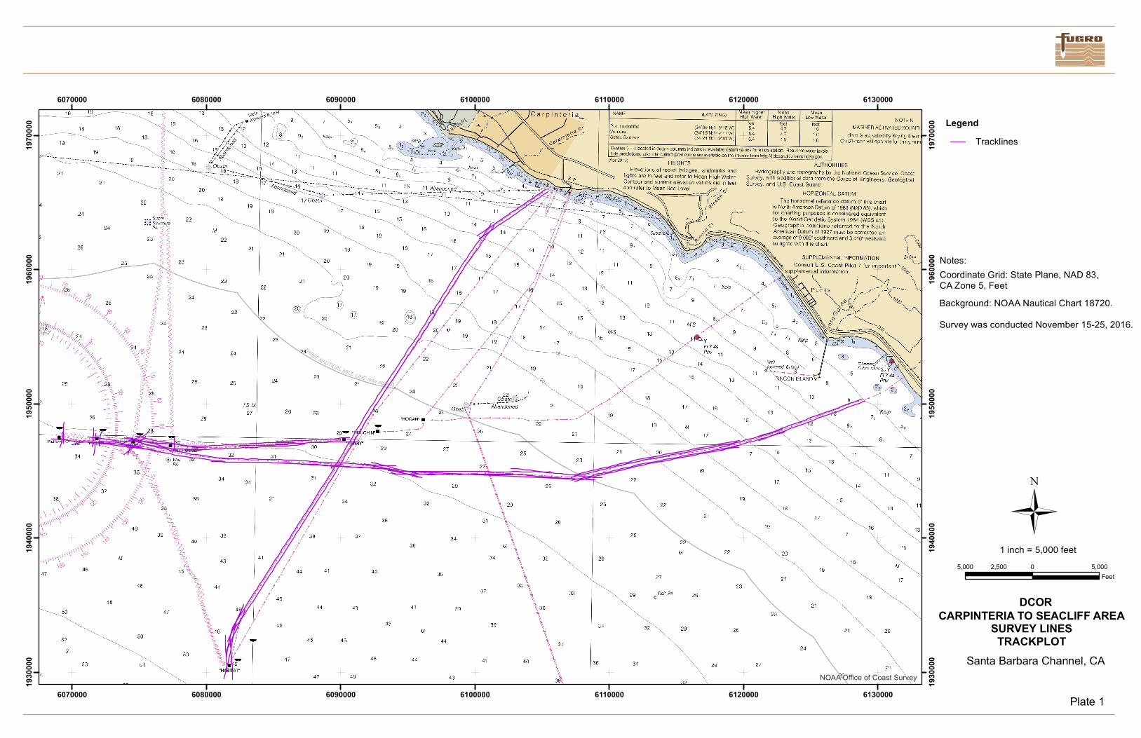
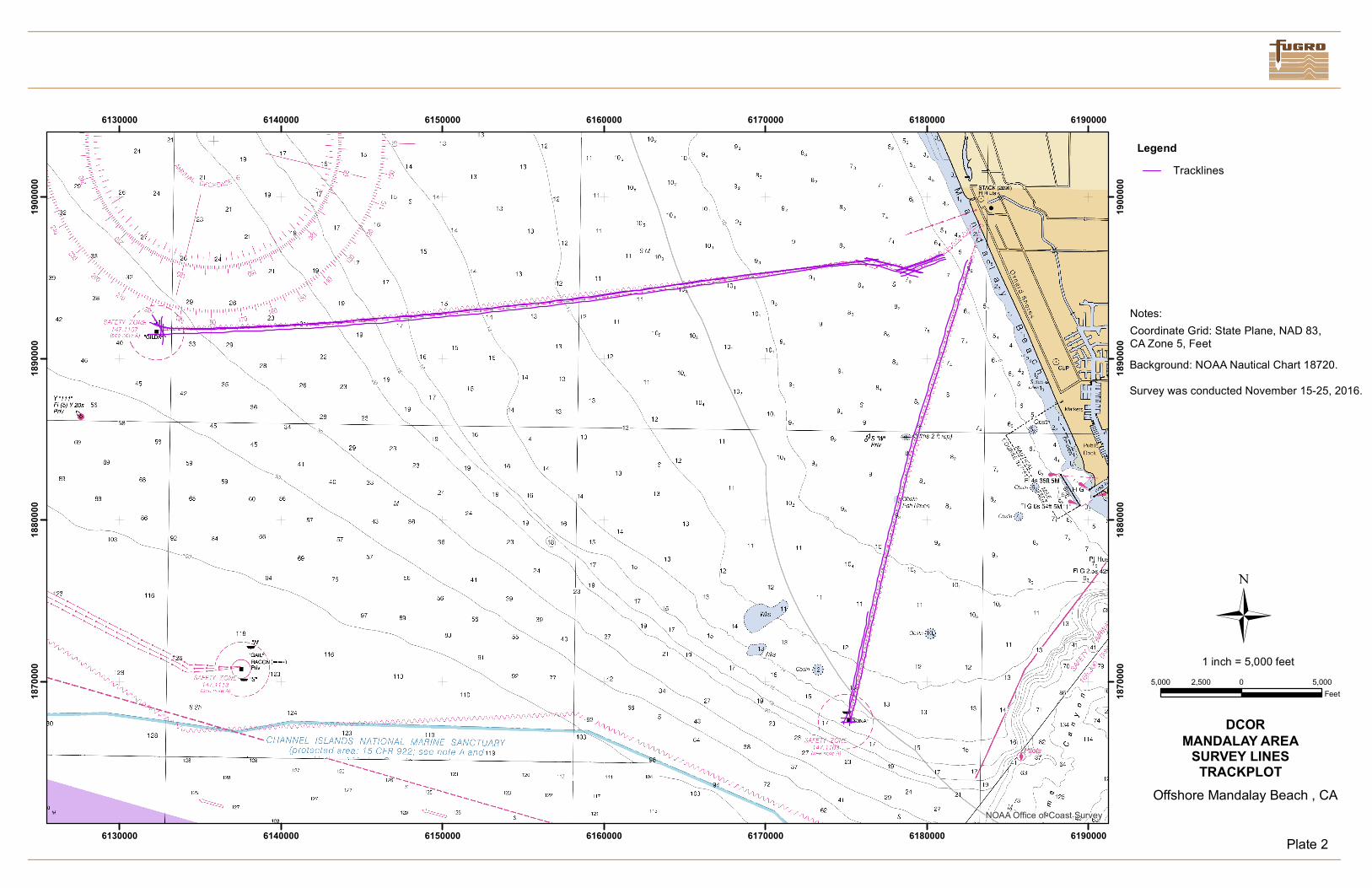
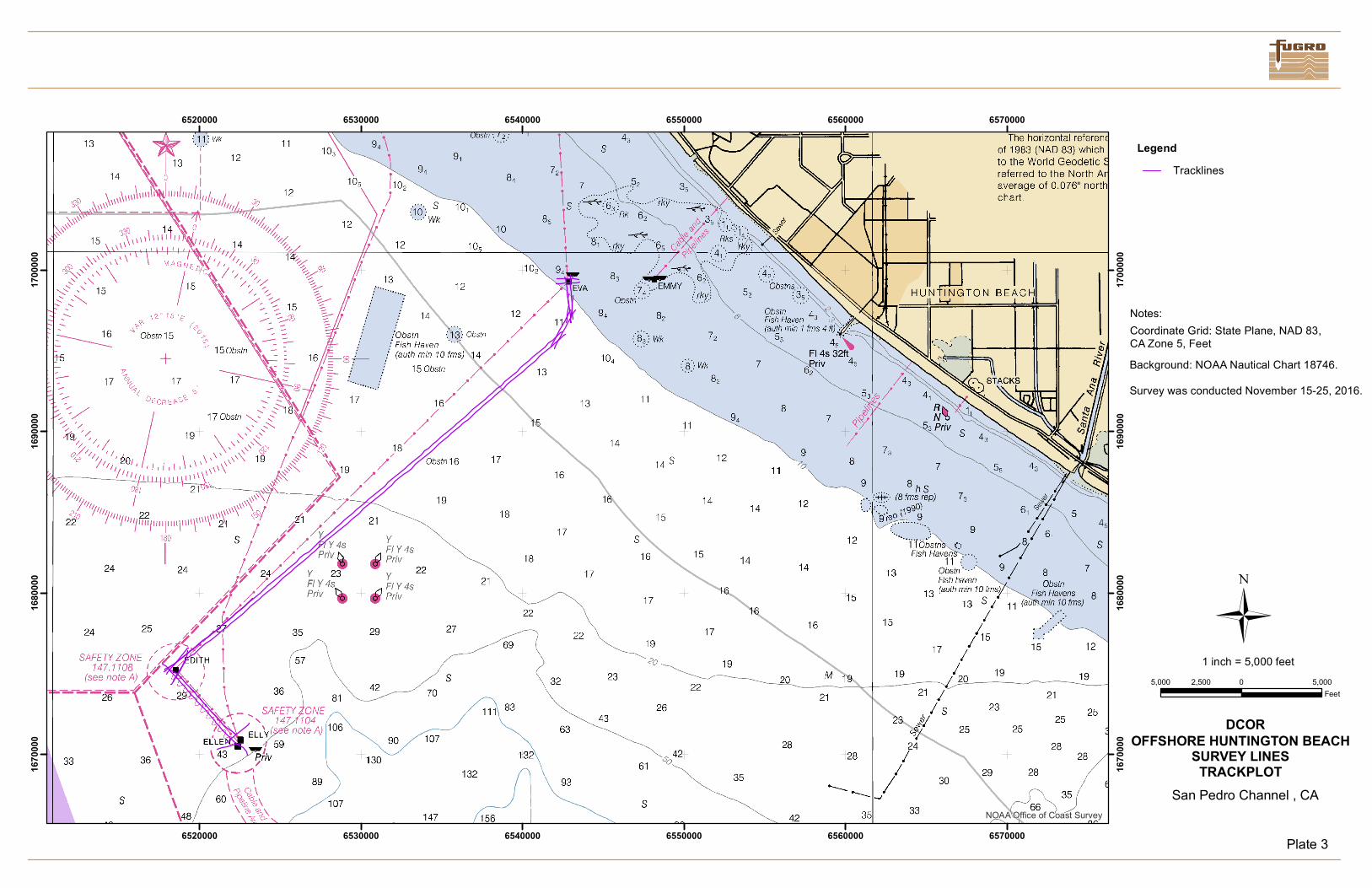
A chart of the survey trackplot is included at the end of this report.
1.4 SPATIAL INFORMATION RELATED TO SURVEY TRACKLINES
Accompanying and made part of this report is the digital ArcGIS shapefiles depicting the survey trackplot.
1.5 NATURE AND LOCATION OF ENVORNMENTAL HAZARDS ENCOUNTERED
No environmental hazards were encountered during survey operations.
1.6 ACCIDENT, INJURY, DAMAGE TO OR LOSS OF PROPERTY
No accidents or injuries occurred during the operations of the project, and no damages or loss of property
was reported.
CALIFORNIA STATE LANDS COMMISSION
FIELD OPERATIONS AND COMPLIANCE REPORT
Fugro Document No. 23.00007195_CSLC_Report R0 Page 3 of 9
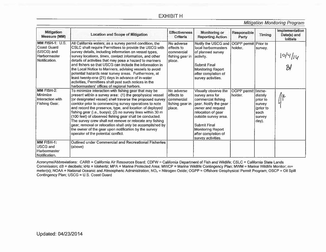
2. BIOLOGICAL INFORMATION
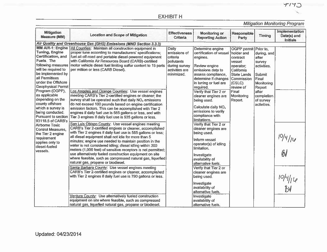
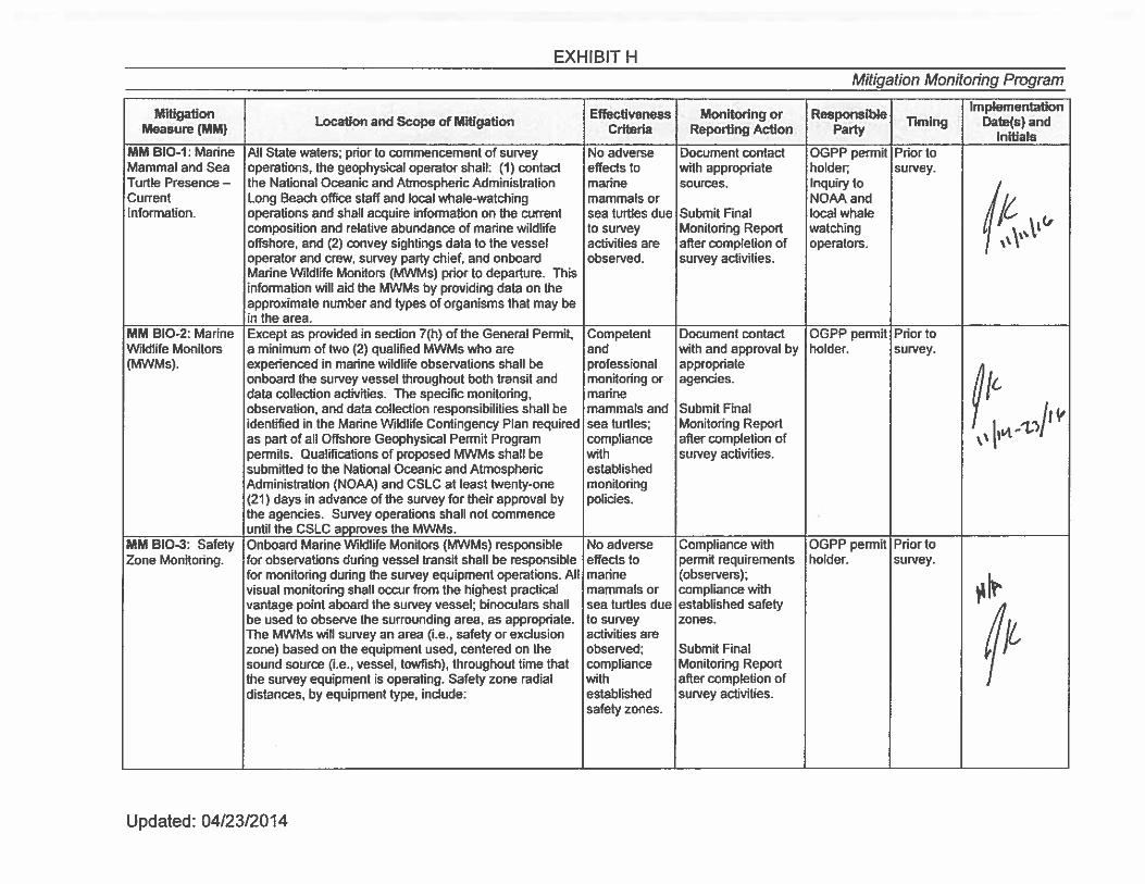
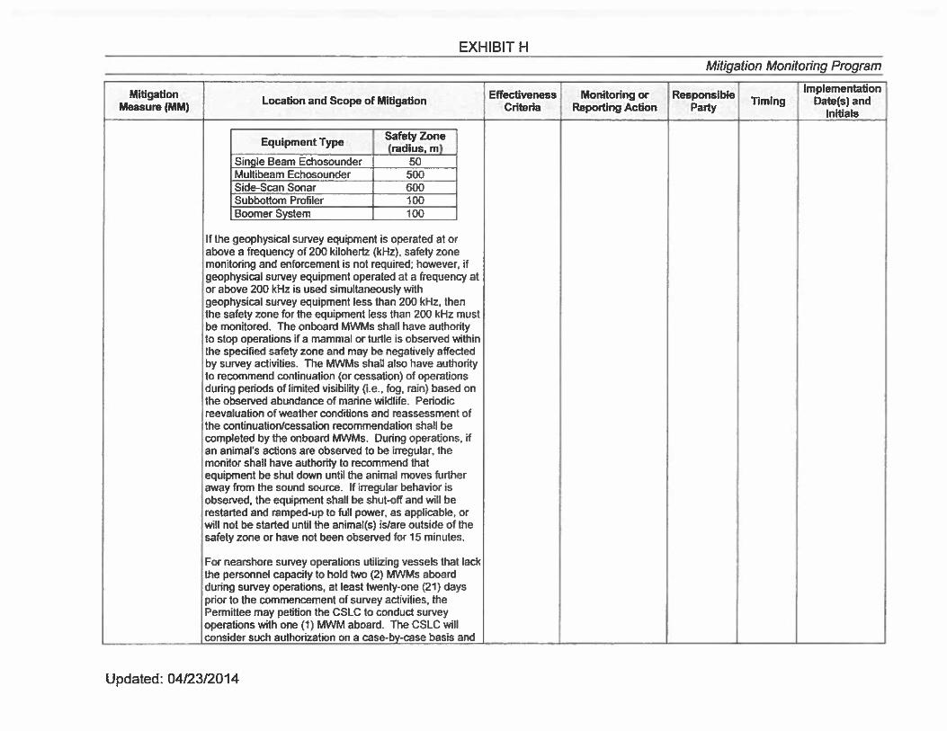
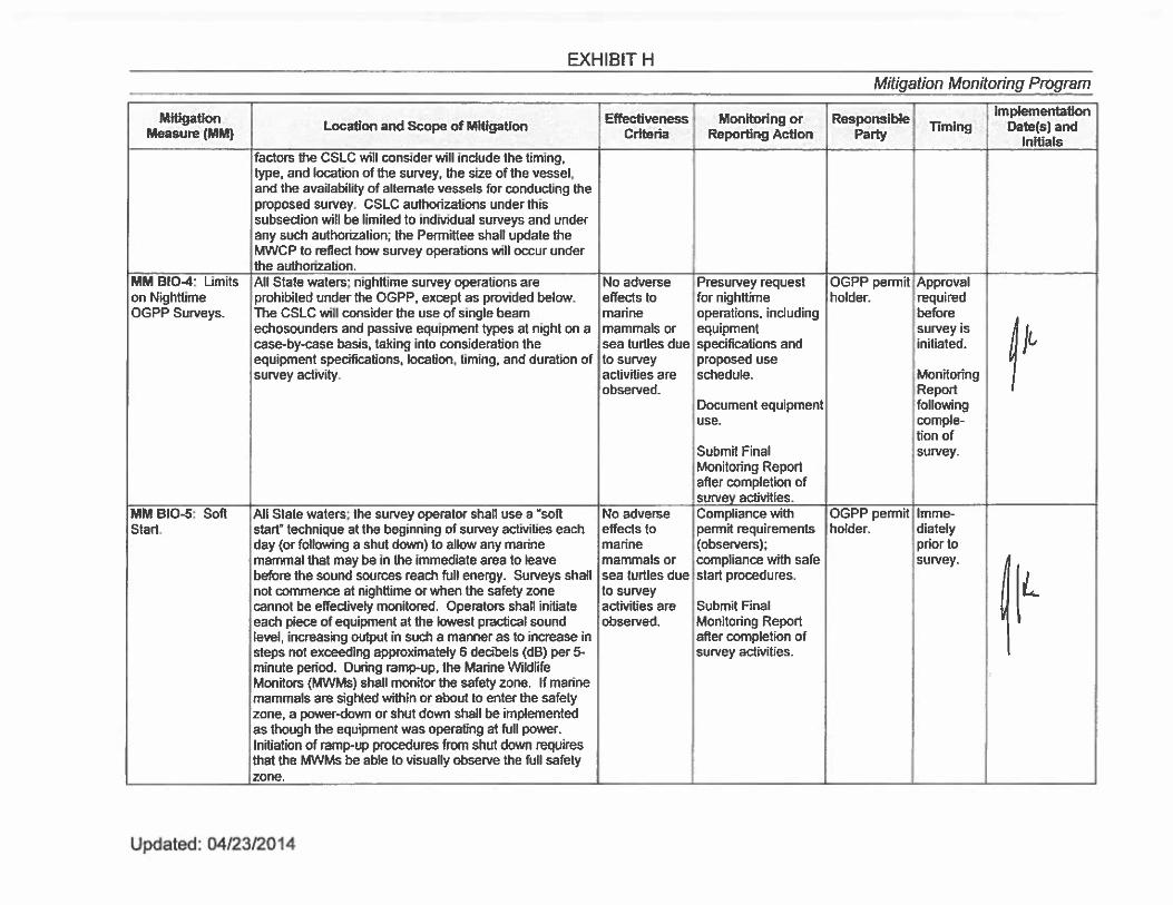
Because the project included surveys within California State Lands Commission (CSLC) jurisdiction,
using geophysical equipment operated at a frequency above 200 kHz, these surveys were conducted
during daylight hours only and a marine mammal observer was onboard. A copy of the final Marine
Wildlife Monitoring Report can be found in Appendix A. In accordance with CSLC regulations, a
completed copy of Exhibit H taken from Fugro Geophysical Permit PRC 8391.9 has been completed
with acknowledgements and included in Appendix B.
.
CALIFORNIA STATE LANDS COMMISSION
FIELD OPERATIONS AND COMPLIANCE REPORT
Fugro Document No. 23.00007195_CSLC_Report R0 Appendices
APPENDICES
A. MARINE FIELD MONITORING REPORT AND SURVEY TRACKPLOT
B. EXHIBIT H
CALIFORNIA STATE LANDS COMMISSION
FIELD OPERATIONS AND COMPLIANCE REPORT
Fugro Document No. 23.00007195_CSLC_Report R0 Appendix A
A. MARINE FIELD MONITORING REPORT AND SURVEY TRACKPLOT
MARINE WILDLIFE MONITORING REPORT
DCOR LLC. SIDE SCAN SONAR SURVEY OFFSHORE SOUTHERN CALIFORNIA
Project No. 1602-2781
Prepared for:
Fugro Pelagos, Inc. 4820 McGrath St., Suite 100
Ventura, California 93003
Prepared by:
Padre Associates, Inc. 369 Pacific Street
San Luis Obispo, California 93401
DECEMBER 2016
Fugro Pelagos, Inc. Marine Wildlife Monitoring Report Project No. 1602-2781
- i -
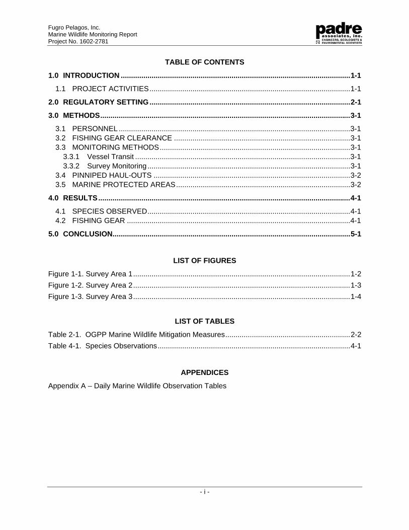
TABLE OF CONTENTS
1.0 INTRODUCTION ................................................................................................................ 1-1
1.1 PROJECT ACTIVITIES .................................................................................................. 1-1
2.0 REGULATORY SETTING .................................................................................................. 2-1
3.0 METHODS .......................................................................................................................... 3-1
3.1 PERSONNEL ................................................................................................................. 3-1 3.2 FISHING GEAR CLEARANCE ...................................................................................... 3-1 3.3 MONITORING METHODS ............................................................................................. 3-1
3.3.1 Vessel Transit ......................................................................................................... 3-1 3.3.2 Survey Monitoring ................................................................................................... 3-1
3.4 PINNIPED HAUL-OUTS ................................................................................................ 3-2 3.5 MARINE PROTECTED AREAS ..................................................................................... 3-2
4.0 RESULTS ........................................................................................................................... 4-1
4.1 SPECIES OBSERVED ................................................................................................... 4-1 4.2 FISHING GEAR ............................................................................................................. 4-1
5.0 CONCLUSION .................................................................................................................... 5-1
LIST OF FIGURES
Figure 1-1. Survey Area 1 .......................................................................................................... 1-2
Figure 1-2. Survey Area 2 .......................................................................................................... 1-3
Figure 1-3. Survey Area 3 .......................................................................................................... 1-4
LIST OF TABLES
Table 2-1. OGPP Marine Wildlife Mitigation Measures ............................................................. 2-2
Table 4-1. Species Observations .............................................................................................. 4-1
APPENDICES
Appendix A – Daily Marine Wildlife Observation Tables
Fugro Pelagos, Inc. Marine Wildlife Monitoring Report Project No. 1602-2781
- 1-1 -
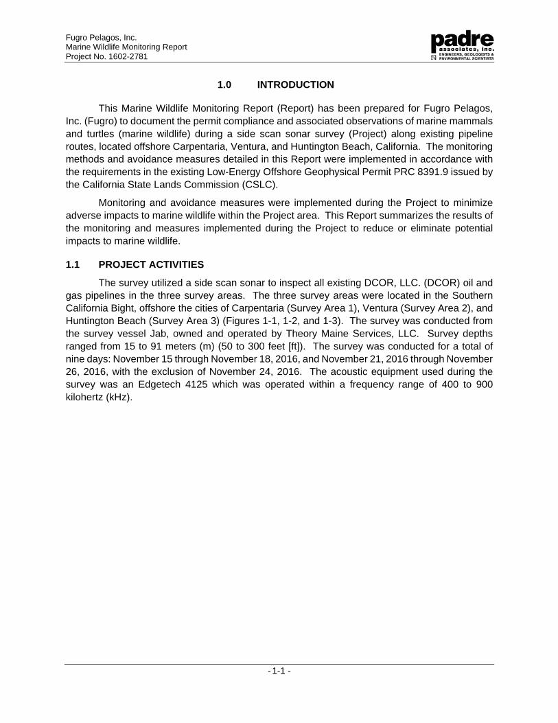
1.0 INTRODUCTION
This Marine Wildlife Monitoring Report (Report) has been prepared for Fugro Pelagos, Inc. (Fugro) to document the permit compliance and associated observations of marine mammals and turtles (marine wildlife) during a side scan sonar survey (Project) along existing pipeline routes, located offshore Carpentaria, Ventura, and Huntington Beach, California. The monitoring methods and avoidance measures detailed in this Report were implemented in accordance with the requirements in the existing Low-Energy Offshore Geophysical Permit PRC 8391.9 issued by the California State Lands Commission (CSLC).
Monitoring and avoidance measures were implemented during the Project to minimize adverse impacts to marine wildlife within the Project area. This Report summarizes the results of the monitoring and measures implemented during the Project to reduce or eliminate potential impacts to marine wildlife.
1.1 PROJECT ACTIVITIES
The survey utilized a side scan sonar to inspect all existing DCOR, LLC. (DCOR) oil and gas pipelines in the three survey areas. The three survey areas were located in the Southern California Bight, offshore the cities of Carpentaria (Survey Area 1), Ventura (Survey Area 2), and Huntington Beach (Survey Area 3) (Figures 1-1, 1-2, and 1-3). The survey was conducted from the survey vessel Jab, owned and operated by Theory Maine Services, LLC. Survey depths ranged from 15 to 91 meters (m) (50 to 300 feet [ft]). The survey was conducted for a total of nine days: November 15 through November 18, 2016, and November 21, 2016 through November 26, 2016, with the exclusion of November 24, 2016. The acoustic equipment used during the survey was an Edgetech 4125 which was operated within a frequency range of 400 to 900 kilohertz (kHz).
Hogan to
Sh ore Pi peli
ne Bundl
e
Power Cabl e ( Ab andoned)
Punt a G or da
Hil da
Hazel
Rinco n I sland
Pi peli ne (A bandoned )
Power Cabl e ( Ab andoned)
NOAA Office of Coast Survey
6070000
6070000
6080000
6080000
6090000
6090000
6100000
6100000
6110000
6110000
6120000
6120000
6130000
6130000
1930
000
1930
000
1940
000
1940
000
1950
000
1950
000
1960
000
1960
000
1970
000
1970
000
Plate 1
Ü1 inch = 5,000 feet
5,000 0 5,0002,500Feet
DCOR
Santa Barbara Channel, CA
CARPINTERIA TO SEACLIFF AREASURVEY LINES
TRACKPLOT
Coordinate Grid: State Plane, NAD 83, CA Zone 5, FeetBackground: NOAA Nautical Chart 18720.Survey was conducted November 15-25, 2016.
Notes:
TracklinesLegend
8" Ga s ( M- 29)
8" Sour Gas ( M- 30)
Gai l
GI NA
NOAA Office of Coast Survey
6130000
6130000
6140000
6140000
6150000
6150000
6160000
6160000
6170000
6170000
6180000
6180000
6190000
6190000
1870
000
1870
000
1880
000
1880
000
1890
000
1890
000
1900
000
1900
000
Plate 2
Ü1 inch = 5,000 feet
5,000 0 5,0002,500Feet
DCOR
Offshore Mandalay Beach , CA
MANDALAY AREASURVEY LINES
TRACKPLOT
Coordinate Grid: State Plane, NAD 83, CA Zone 5, FeetBackground: NOAA Nautical Chart 18720.Survey was conducted November 15-25, 2016.
Notes:
TracklinesLegend
16" O il
Pi peli n
e
NOAA Office of Coast Survey
6520000
6520000
6530000
6530000
6540000
6540000
6550000
6550000
6560000
6560000
6570000
6570000
1670
000
1670
000
1680
000
1680
000
1690
000
1690
000
1700
000
1700
000
Plate 3
Ü1 inch = 5,000 feet
5,000 0 5,0002,500Feet
DCOR
San Pedro Channel , CA
OFFSHORE HUNTINGTON BEACHSURVEY LINES
TRACKPLOT
Coordinate Grid: State Plane, NAD 83, CA Zone 5, FeetBackground: NOAA Nautical Chart 18746.Survey was conducted November 15-25, 2016.
Notes:
TracklinesLegend
Fugro Pelagos, Inc. Marine Wildlife Monitoring Report Project No. 1602-2781
- 2-1 -
2.0 REGULATORY SETTING
The CSLC Offshore Geophysical Permit Program (OGPP) requires individual surveying entities to obtain an OGPP non-exclusive permit to perform low-energy geophysical surveys of the ocean bottom and marine environment. Under the OGPP, operators are permitted to conduct surveys using specific types of geophysical equipment subject to permit terms and conditions developed to minimize impacts to marine wildlife and the coastal environment. In August 2013, the CSLC identified potential impacts to marine wildlife from acoustical survey equipment within a Mitigated Negative Declaration (MND), and identified mitigation measures that would reduce or avoid those impacts to a point where no significant impacts would occur. This Report details the compliance with the applicable OGPP permit mitigation measures as outlined in Table 2-1.
In addition, The United States Marine Mammal Protection Act (MMPA) of 1972, amended 1994, protects all marine mammals, including cetaceans (whales, dolphins, and porpoises), pinnipeds (seals and sea lions), sirenians (manatees and dugongs), sea otters, and polar bears within the waters of the United States. Specifically, the MMPA prohibits the intentional killing or harassment of these marine mammals; however, incidental harassment, with authorization from the appropriate Federal agency, may be permitted. National Oceanic and Atmospheric Administration (NOAA) Fisheries is responsible for enforcing the MMPA.
Special status species are protected by the Federal Endangered Species Act (ESA) of 1973 (Section 9 and implementing regulations 50 CFR Part 17). The Federal ESA makes it unlawful to harass, harm, pursue, hunt, shoot, wound, kill, trap, capture, or collect an endangered species, or to attempt to engage in any such conduct. Anyone violating the provisions of the Federal ESA and regulations is subject to a fine and imprisonment. An “endangered species” is any species which the Secretaries of the Department of the Interior and/or the Department of Commerce determine is in danger of extinction throughout all or a portion of its range. A “threatened species” is any species which the Secretaries determine is likely to become an endangered species within the foreseeable future throughout all or a significant portion of its range. The United States Fish and Wildlife Service (USFWS) and NOAA Fisheries are responsible for implementation of the Federal ESA.
Fugro Pelagos, Inc. Marine Wildlife Monitoring Report Project No. 1602-2781
- 2-2 -
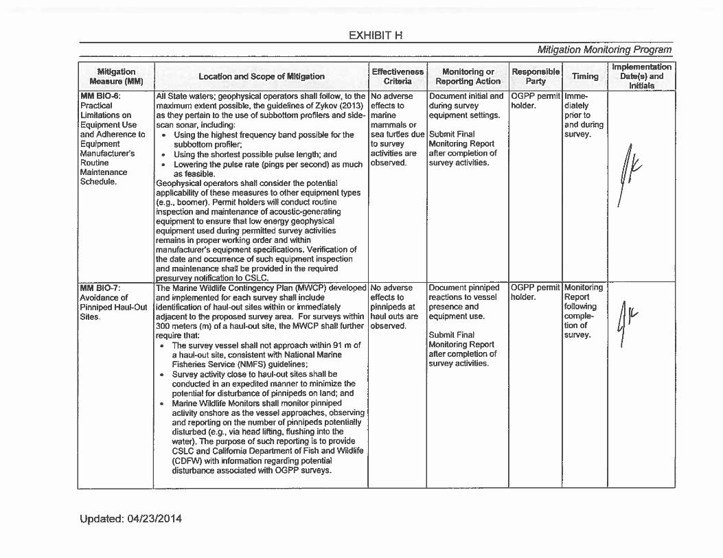
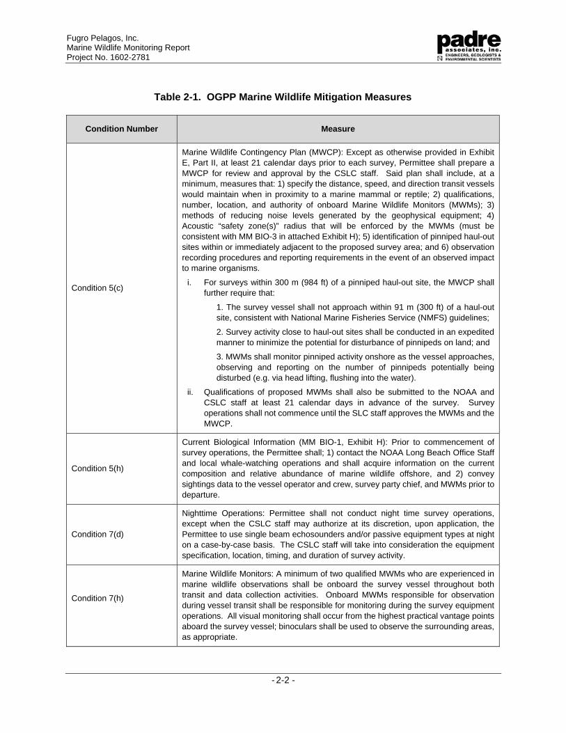
Table 2-1. OGPP Marine Wildlife Mitigation Measures
Condition Number Measure
Condition 5(c)
Marine Wildlife Contingency Plan (MWCP): Except as otherwise provided in Exhibit E, Part II, at least 21 calendar days prior to each survey, Permittee shall prepare a MWCP for review and approval by the CSLC staff. Said plan shall include, at a minimum, measures that: 1) specify the distance, speed, and direction transit vessels would maintain when in proximity to a marine mammal or reptile; 2) qualifications, number, location, and authority of onboard Marine Wildlife Monitors (MWMs); 3) methods of reducing noise levels generated by the geophysical equipment; 4) Acoustic “safety zone(s)” radius that will be enforced by the MWMs (must be consistent with MM BIO-3 in attached Exhibit H); 5) identification of pinniped haul-out sites within or immediately adjacent to the proposed survey area; and 6) observation recording procedures and reporting requirements in the event of an observed impact to marine organisms.
i. For surveys within 300 m (984 ft) of a pinniped haul-out site, the MWCP shall further require that:
1. The survey vessel shall not approach within 91 m (300 ft) of a haul-out site, consistent with National Marine Fisheries Service (NMFS) guidelines;
2. Survey activity close to haul-out sites shall be conducted in an expedited manner to minimize the potential for disturbance of pinnipeds on land; and
3. MWMs shall monitor pinniped activity onshore as the vessel approaches, observing and reporting on the number of pinnipeds potentially being disturbed (e.g. via head lifting, flushing into the water).
ii. Qualifications of proposed MWMs shall also be submitted to the NOAA and CSLC staff at least 21 calendar days in advance of the survey. Survey operations shall not commence until the SLC staff approves the MWMs and the MWCP.
Condition 5(h)
Current Biological Information (MM BIO-1, Exhibit H): Prior to commencement of survey operations, the Permittee shall; 1) contact the NOAA Long Beach Office Staff and local whale-watching operations and shall acquire information on the current composition and relative abundance of marine wildlife offshore, and 2) convey sightings data to the vessel operator and crew, survey party chief, and MWMs prior to departure.
Condition 7(d)
Nighttime Operations: Permittee shall not conduct night time survey operations, except when the CSLC staff may authorize at its discretion, upon application, the Permittee to use single beam echosounders and/or passive equipment types at night on a case-by-case basis. The CSLC staff will take into consideration the equipment specification, location, timing, and duration of survey activity.
Condition 7(h)
Marine Wildlife Monitors: A minimum of two qualified MWMs who are experienced in marine wildlife observations shall be onboard the survey vessel throughout both transit and data collection activities. Onboard MWMs responsible for observation during vessel transit shall be responsible for monitoring during the survey equipment operations. All visual monitoring shall occur from the highest practical vantage points aboard the survey vessel; binoculars shall be used to observe the surrounding areas, as appropriate.
Fugro Pelagos, Inc. Marine Wildlife Monitoring Report Project No. 1602-2781
- 2-3 -
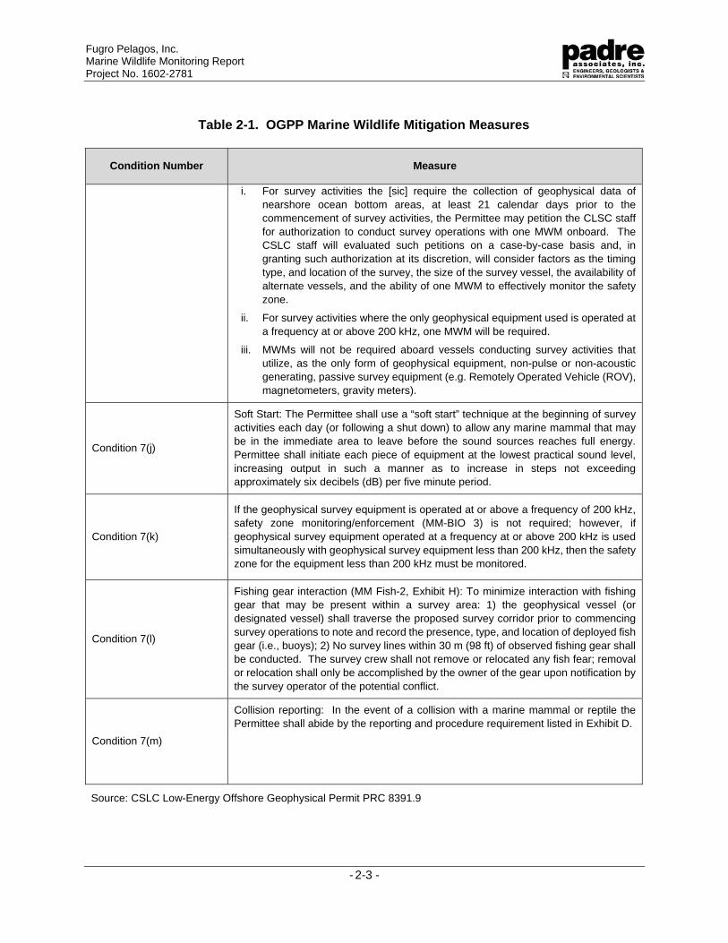
Table 2-1. OGPP Marine Wildlife Mitigation Measures
Condition Number Measure
i. For survey activities the [sic] require the collection of geophysical data of nearshore ocean bottom areas, at least 21 calendar days prior to the commencement of survey activities, the Permittee may petition the CLSC staff for authorization to conduct survey operations with one MWM onboard. The CSLC staff will evaluated such petitions on a case-by-case basis and, in granting such authorization at its discretion, will consider factors as the timing type, and location of the survey, the size of the survey vessel, the availability of alternate vessels, and the ability of one MWM to effectively monitor the safety zone.
ii. For survey activities where the only geophysical equipment used is operated at a frequency at or above 200 kHz, one MWM will be required.
iii. MWMs will not be required aboard vessels conducting survey activities that utilize, as the only form of geophysical equipment, non-pulse or non-acoustic generating, passive survey equipment (e.g. Remotely Operated Vehicle (ROV), magnetometers, gravity meters).
Condition 7(j)
Soft Start: The Permittee shall use a “soft start” technique at the beginning of survey activities each day (or following a shut down) to allow any marine mammal that may be in the immediate area to leave before the sound sources reaches full energy. Permittee shall initiate each piece of equipment at the lowest practical sound level, increasing output in such a manner as to increase in steps not exceeding approximately six decibels (dB) per five minute period.
Condition 7(k)
If the geophysical survey equipment is operated at or above a frequency of 200 kHz, safety zone monitoring/enforcement (MM-BIO 3) is not required; however, if geophysical survey equipment operated at a frequency at or above 200 kHz is used simultaneously with geophysical survey equipment less than 200 kHz, then the safety zone for the equipment less than 200 kHz must be monitored.
Condition 7(l)
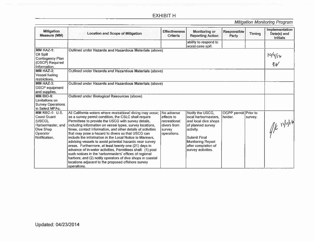
Fishing gear interaction (MM Fish-2, Exhibit H): To minimize interaction with fishing gear that may be present within a survey area: 1) the geophysical vessel (or designated vessel) shall traverse the proposed survey corridor prior to commencing survey operations to note and record the presence, type, and location of deployed fish gear (i.e., buoys); 2) No survey lines within 30 m (98 ft) of observed fishing gear shall be conducted. The survey crew shall not remove or relocated any fish fear; removal or relocation shall only be accomplished by the owner of the gear upon notification by the survey operator of the potential conflict.
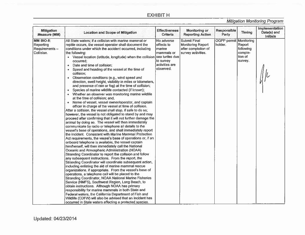
Condition 7(m)
Collision reporting: In the event of a collision with a marine mammal or reptile the Permittee shall abide by the reporting and procedure requirement listed in Exhibit D.
Source: CSLC Low-Energy Offshore Geophysical Permit PRC 8391.9
Fugro Pelagos, Inc. Marine Wildlife Monitoring Report Project No. 1602-2781
- 3-1 -
3.0 METHODS
Three days prior to the initiation of the survey, Padre marine biologists contacted NOAA Fisheries Long Beach office staff and local whale-watching groups to inquire about the species and numbers of recently observed marine wildlife near the survey area. During survey operations, the Marine Wildlife Monitor (MWM) onboard the survey vessel was responsible for observing wildlife and their behaviors during transit and data collection operations. Monitoring conditions and avoidance measures designed to decrease the potential impacts to marine wildlife were implemented as detailed in the following sections.
3.1 PERSONNEL
The side scan sonar equipment was operated at frequencies greater than 200 kHz; therefore, only one NOAA-approved Padre MWM was required during survey operations. Jennifer Klaib was the MWM onboard the survey vessel on November 15 and 16, 2016, while Patrick Crooks was the MWM onboard from November 17 through November 26, 2016. Monitoring was conducted during all transit and side scan sonar operations.
3.2 FISHING GEAR CLEARANCE
In accordance with geophysical permit conditions, a fishing gear clearance was conducted prior to the start of survey operations. The survey vessel traveled along the survey corridor to confirm the presence and/or absence of fishing gear within the survey area. In addition, the onboard MWM aided in the identification and avoidance of fishing gear during survey operations.
3.3 MONITORING METHODS
Monitoring occurred during all Project activities within State waters.
3.3.1 Vessel Transit
The survey vessel transited to and from Marina del Rey, California, to Survey Area 3, and from Ventura Harbor, California to Survey Areas 1 and 2. During vessel transit, there was the potential for encountering marine wildlife; therefore, a MWM was positioned at the highest safe vantage point for a clear view of the ocean within the vessel’s path. To minimize the chance of collision with, or disturbance of, marine wildlife, the MWM recommended that the vessel maintain a minimum distance of 91 m (300 ft) from marine wildlife. If marine wildlife was observed within the path of the transiting vessel, the monitor reported that observation to the vessel operator, who slowed the vessel and/or changed course in order to avoid contact.
3.3.2 Survey Monitoring
Prior to the start of data collection, survey operators utilized a “soft start” technique to allow any marine wildlife that may be in the survey area to leave before the sound source reached full energy level. MWM was prepared with the appropriate safety and monitoring equipment to conduct observations, including Nikon 7 x 50 low light reticulated binoculars for daytime and low light observations. Survey activities were conducted during daylight hours only.
MWM visually scanned the general survey area near the survey vessel for wildlife whenever survey equipment was operating. Per the OGPP requirements, no safety zone was
Fugro Pelagos, Inc. Marine Wildlife Monitoring Report Project No. 1602-2781
- 3-2 -
required during the side scan sonar sonar survey. When marine wildlife were observed, the MWM identified the species, counted the number of individual animals present, observed the animals’ behavior, and the animals’ direction/speed of movement. The MWM recorded any distress behaviors and implemented avoidance actions as discussed above, if necessary.
3.4 PINNIPED HAUL-OUTS
Survey Area 1 routes were adjacent to a known pinniped haul-out and/or rookery, the Carpentaria harbor seal rookery. The survey was conducted in November 2016, which is outside of pinniped mating and pupping season. As per Fugro’s OGPP permit, anytime the survey came within 300 m (984 ft) of a pinniped haul-out, the following measures were implemented:
The survey vessel did not approach within 91 m (300 ft) of the haul-out site;
Survey activity adjacent to haul-out sites were conducted in an expedited manner to minimize the potential for disturbance of pinniped on land; and
The MWM monitored pinniped activity onshore as the vessel approaches, observing and reporting on the number of pinnipeds disturbed (i.e., head lifting, flushing into the water, and/or vocalizing in defense).
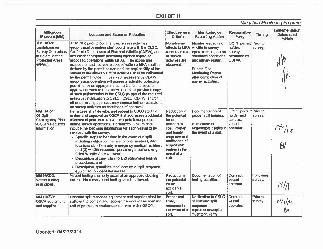
3.5 MARINE PROTECTED AREAS
Survey activities did not occur within any Marine Protected Areas (MPA). Survey Area 1 was located approximately 18.8 km (11.7 mi) north of the Scorpion MPA near Santa Cruz Island, Survey Area 2 was located approximately 7.7 km (4.8 mi) northeast of the Anacapa MPA, and Survey Area 3 was located approximately 2.6 km (1.6 mi) southwest of the Bolsa Chica Basin MPA.
Fugro Pelagos, Inc. Marine Wildlife Monitoring Report Project No. 1602-2781
- 4-1 -
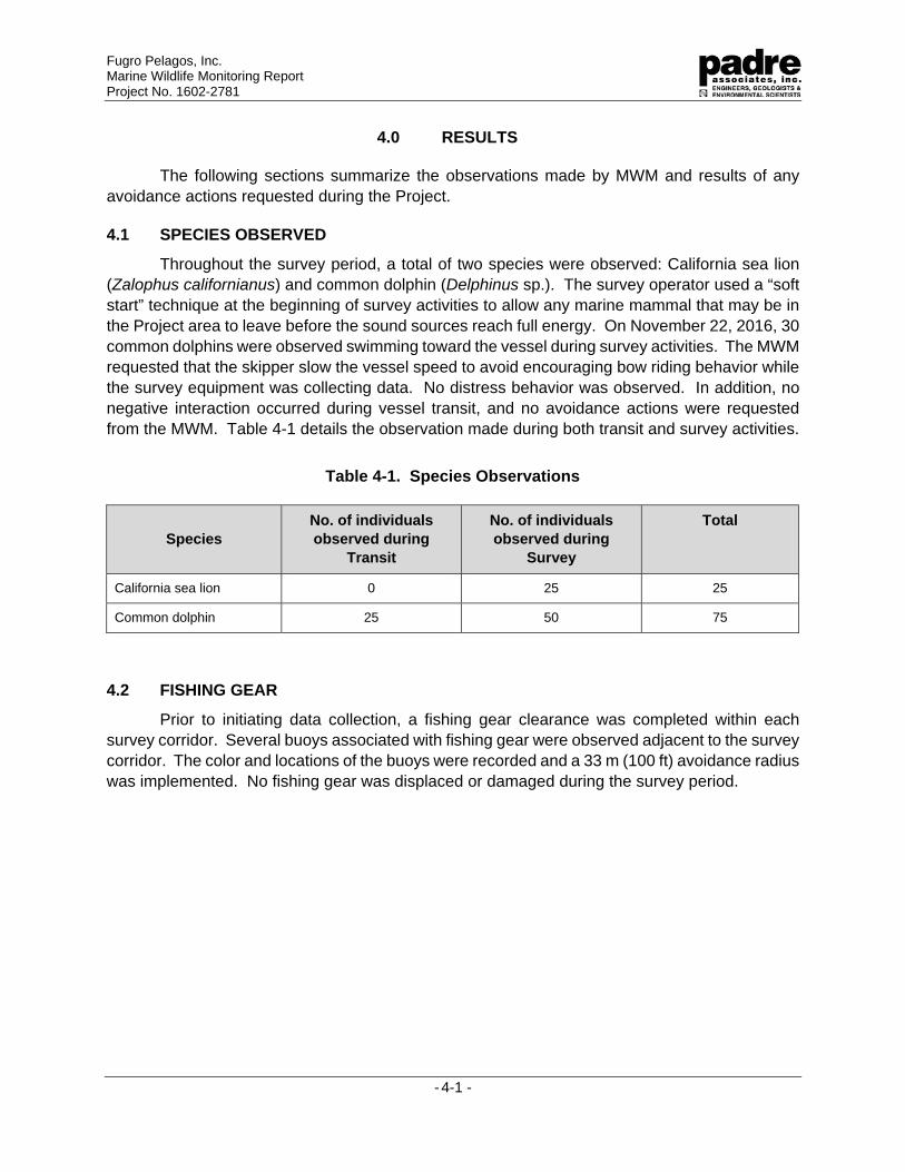
4.0 RESULTS
The following sections summarize the observations made by MWM and results of any avoidance actions requested during the Project.
4.1 SPECIES OBSERVED
Throughout the survey period, a total of two species were observed: California sea lion (Zalophus californianus) and common dolphin (Delphinus sp.). The survey operator used a “soft start” technique at the beginning of survey activities to allow any marine mammal that may be in the Project area to leave before the sound sources reach full energy. On November 22, 2016, 30 common dolphins were observed swimming toward the vessel during survey activities. The MWM requested that the skipper slow the vessel speed to avoid encouraging bow riding behavior while the survey equipment was collecting data. No distress behavior was observed. In addition, no negative interaction occurred during vessel transit, and no avoidance actions were requested from the MWM. Table 4-1 details the observation made during both transit and survey activities.
Table 4-1. Species Observations
Species No. of individuals observed during
Transit
No. of individuals observed during
Survey
Total
California sea lion 0 25 25
Common dolphin 25 50 75
4.2 FISHING GEAR
Prior to initiating data collection, a fishing gear clearance was completed within each survey corridor. Several buoys associated with fishing gear were observed adjacent to the survey corridor. The color and locations of the buoys were recorded and a 33 m (100 ft) avoidance radius was implemented. No fishing gear was displaced or damaged during the survey period.
Fugro Pelagos, Inc. Marine Wildlife Monitoring Report Project No. 1602-2781
- 5-1 -
5.0 CONCLUSION
Two species of marine wildlife were observed during the DCOR side scan sonar survey period. On one occasion, the MWM requested to implement an avoidance measure to discourage marine wildlife from swimming adjacent to the operating equipment. Project activities were never delayed or altered due to encroachment by marine wildlife, and no abnormal behaviors or negative effects were observed. Based on the observations of the MWM, and the cooperative efforts of the Fugro team and vessel crew, no negative Project-related effects to the marine wildlife were observed during the survey period.
CALIFORNIA STATE LANDS COMMISSION
FIELD OPERATIONS AND COMPLIANCE REPORT
Fugro Document No. 23.00007195_CSLC_Report R0 Appendix B
B. EXHIBIT H