W a t e r f r o n t O f f i c e , 1 E a s t v i l l e A v e n u e , T o r o n t o , O n t a r i o M 1 M 2 N 5
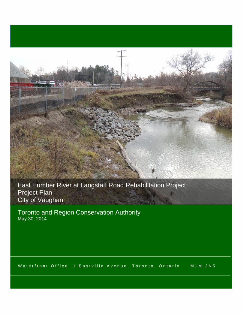
East Humber River at Langstaff Road Rehabilitation Project Project Plan City of Vaughan
Toronto and Region Conservation Authority May 30, 2014
i
Acknowledgements
Toronto and Region Conservation Authority gratefully acknowledge the following people for their contributions to the East Humber River at Langstaff Road Rehabilitation Project. Michael McNamara City of Vaughan Melanie Morris City of Vaughan Robert O’Hara City of Vaughan Imran Khan GHD Jeff Doucette GHD Mark Heaton Ministry of Natural Resources Emily Funnell Ministry of Natural Resources Ashour Rehana Toronto and Region Conservation Authority Maria Parish Toronto and Region Conservation Authority Mark Preston Toronto and Region Conservation Authority Marnie Krokos Toronto and Region Conservation Authority Matt Kenel Toronto and Region Conservation Authority Matthew Johnston Toronto and Region Conservation Authority Mike Puusa Toronto and Region Conservation Authority Moranne McDonnell Toronto and Region Conservation Authority Nick Saccone Toronto and Region Conservation Authority Patricia Newland Toronto and Region Conservation Authority Ralph Toninger Toronto and Region Conservation Authority Rudra Bissoon Toronto and Region Conservation Authority Susan Robertson Toronto and Region Conservation Authority
ii
EXECUTIVE SUMMARY
Toronto and Region Conservation Authority (TRCA) continues to work towards ensuring healthy rivers and shorelines, greenspace and biodiversity, and sustainable communities. One key step in this process is the design and implementation of erosion control works for projects. The East Humber River at Langstaff Road Rehabilitation Project is being completed in accordance with the Class Environmental Assessment for Remedial Flood and Erosion Control Projects (2013) or Class EA, with the objective of reducing risk to life and property, as per the mandate of Conversation Authorities, under the Conservation Authorities Act (R.S.O. 1990). The erosion problem along this section of the East Humber River was first identified to TRCA in 2004 when City of Vaughan staff expressed concern over the close proximity of the erosion scar to their public Works Yard (herein referred to as the “Works Yard”). Following a visual inspection by TRCA staff, it was recommended that remedial works be undertaken to repair the scar; however, no funding was secured and the erosion continued unabated. With the progression of erosion impacting the Works Yard property, TRCA retained Geomorphic Solutions Ltd. to conduct a geomorphic assessment and erosion risk analysis of the East Humber River near the Works Yard in late 2010. Geomorphic Solutions reported that the erosion was likely triggered by straightening of the channel upstream of the site between 1960 and 1966. As a result, this shifted the channel thalweg significantly which changed the meander form of the river and increased lateral migration throughout the project area. As a result of this migration, the erosive forces of the river have been directed towards the Works Yard. The July 8, 2013 storm event further accelerated site erosion and undermined the fence and a portion of the parking lot at the Works Yard. Slight changes in river morphology have concentrated erosive actions to the downstream portion of the scar and the bowstring bridge. This change on site was significant enough to warrant additional surveying works and additional design details for the preferred alternative. A Notice of Intent formally initiating the project under the Class EA, was published in Vaughan Weekly on May 30, 2012. Furthermore, letters were sent to possible interested persons from the City of Vaughan Council members, Aboriginal groups, community groups, and government regulatory agencies. There was no interest in the Project following the notices. As such, a Technical Steering Committee (TSC) comprised of TRCA, City of Vaughan and Ministry of Natural Resources (MNR) representatives was created to review conceptual options and provide guidance on the overall design. The preferred solution, determined through the Class EA process for this project, includes stabilizing the east bank with a vegetated stone buttress and rootwads. This bank protection will extend downstream from approximately mid-scour to the concrete abutment of a bowstring bridge that is currently closed to the public due to safety issues. The west bank will have a similar treatment protecting the area upstream of the bridge abutment to ensure the river planform does not change and place Langstaff Road at risk. Following the thirty (30) day public review period of this Project Plan and the successful resolution of any concerns received during the review period, TRCA intends to finalize the detailed design of the preferred solution and obtain the necessary approvals required to proceed to the implementation phase of this project.
iii
Table of Contents
1.0 INTRODUCTION .................................................................................................................... 1
1.1 Relationship of the Undertaking to the Environmental Assessment Act ......................... 1 1.2 Purpose of the Undertaking .................................................................................................. 4 1.3 Site Description ...................................................................................................................... 4 1.4 General Description of the Undertaking .............................................................................. 7 1.5 Rationale for Undertaking ..................................................................................................... 8
2.0 BACKGROUND ...................................................................................................................... 8
2.1 History of the Problem ........................................................................................................... 8 2.2 Identification of Previous Studies ...................................................................................... 10
2.2.1 Geomorphic Assessments ................................................................................................ 10 2.2.2 Planning Documents ......................................................................................................... 10 2.2.3 Aquatic and Terrestrial Habitat Reports ........................................................................... 11 2.2.4 Socioeconomic and Cultural Heritage Studies ................................................................. 12
2.3 Stage 1 and 2 Archaeological Assessment ........................................................................... 17 2.4 Justification of Conservation Authority Involvement .............................................................. 17
3.0 BASELINE ENVIRONMENTAL INVENTORY ...................................................................... 19
3.1 Existing Site Conditions ...................................................................................................... 20 3.1.1 Physical Environment ....................................................................................................... 20 3.1.2 Biological Environment ..................................................................................................... 23 3.1.3 Cultural Environment ........................................................................................................ 30 3.1.4 Socioeconomic Environment ............................................................................................ 31 3.1.5 Engineering/Technical Environment ................................................................................. 32
4.0 EVALUATION OF REMEDIAL ALTERNATIVE OPTIONS .................................................. 33
4.1 Description of Preliminary Concepts ...................................................................................... 33 4.1.1 Preliminary Option 1 - “Do Nothing” Alternative ............................................................... 33 4.1.2 Preliminary Option 2 – Local Armouring without Channel Infilling .................................... 35 4.1.3 Preliminary Option 3 – Local Armouring and Downstream Protection without Channel Infilling 37 4.1.4 Preliminary Option 4 – Minor Realignment Works ............................................................ 39
4.2 Evaluation of Preliminary Concepts .................................................................................. 41 4.3 Selection of the Preferred Alternative ................................................................................ 43 4.4 Refinement of the Preferred Alternative ............................................................................ 43
5.0 ENVIRONMENTAL SCREENING ......................................................................................... 43
5.1 Detailed Environmental Analysis of the Preferred Alternatives ...................................... 43 5.1.1 Physical Environment ....................................................................................................... 47 5.1.2 Biological Environment ..................................................................................................... 47 5.1.3 Cultural Environment ........................................................................................................ 48 5.1.4 Socioeconomic Environment ............................................................................................ 49 5.1.5 Engineering/Technical Environment ................................................................................. 49
6.0 SUMMARY ........................................................................................................................... 49
iv
6.1 Role of the Community Liaison Committee ...................................................................... 49 6.2 Public Notifications and Consultation ............................................................................... 50
6.2.1 Project Initiation ................................................................................................................ 51 6.2.2 Notice of Intent (NOI) ........................................................................................................ 51 6.2.3 Technical Steering Committee .......................................................................................... 51 6.2.4 Technical Steering Committee Meeting #1 ....................................................................... 52 6.2.5 Technical Steering Committee Meeting #2 ....................................................................... 52 6.2.6 Notice of Project Approval ............................................................................................... 52
6.3 First Nation and Aboriginal Group Consultation .............................................................. 52 6.3.1 Monitoring Program .......................................................................................................... 53
7.0 REFERENCES ..................................................................................................................... 53
v
Figures
Figure 1. General location of Project Area. Source: Bing Maps, 2012. ..................................................... 1 Figure 2. Class Environmental Assessment Planning and Design Process. Source: CO, 2013. ............ 3 Figure 3. Topographic map of project area. Source: TRCA, 2011. ........................................................... 4 Figure 4: Eroded bank by Works Yard in 2006. Source: TRCA, 2006. ..................................................... 5 Figure 5: Emergency stone works in 2006. Source: TRCA, 2011. ............................................................ 5 Figure 6. Eroded bank adjacent to Works Yard fence in 2012. Source: TRCA, 2012 .............................. 6 Figure 7. East bank facing upstream after July 8, 2013 storm event. Source: TRCA, 2013............. 6 Figure 8: Historical air photos from 1946 (left) and 1983 (right). Source: TRCA. ................................... 12 Figure 9: Detail of 1860 Tremaine Map – York Country. Source: TRCA, 2012. ..................................... 16 Figure 10: Detail of 1878 Miles & Co. Map - York County. Source: TRCA, 2012. .................................. 17 Figure 11: Projected channel migration rates. Source: Geomorphic Solutions, 2011. ........................... 19 Figure 12. General location of the “L” rating flora species within the vicinity of project area. Source: TRCA, 2013. ............................................................................................................................................ 24 Figure 13. Biological ESAs near the Project area. Source: TRCA, 2013. ............................................... 27 Figure 14. General location of the “L” rating fauna species within the vicinity of project area. Source: TRCA, 2013. ............................................................................................................................................ 28 Figure 15: Boyd Conservation Area ANSI. Source: TRCA, 2013. .......................................................... 30 Figure 16: Option 1: Do Nothing. Source: GHD, 2013. ........................................................................... 34 Figure 17. Proposed Preliminary Option 2. Source: GHD, 2013. ............................................................ 36 Figure 18. Proposed Preliminary Option 3. Source: GHD, 2013. ............................................................ 38 Figure 19. Proposed Preliminary Option 4. Source: GHD, 2013. ............................................................ 40
Tables
Table 1: Air Quality Readings for Toronto West. ..................................................................................... 21 Table 3: Typical L - Rank Description. .................................................................................................... 23 Table 4: Flora Species and Level of Concern near Study Area. ............................................................. 25 Table 5: Fauna Species and Level of Concern near Study Area. ........................................................... 28 Table 6. Evaluation of preliminary alternatives matrix. ............................................................................ 42 Table 7. Detailed Environmental Analysis of the Preferred Alternative. .................................................. 45
vi
List of Appendices
Appendix A Criteria and Implementation Procedures for Valley & Stream Corridor Regeneration and Remedial Works Projects – TRCA, 1994
Appendix B Redside Dace Recovery Plan – MNR, February, 2010 TRCA Fisheries Data Granger Greenway Terrestrial Biological Assessment – TRCA, November, 2012 TRCA Flow Data
Appendix C Archaeology Clearance Letter (TRCA), August 31, 2011 Memo from Gavin Miller (TRCA), June 18, 2009 Memo from Paul Prior (TRCA) September 18, 2012 Memo from Gavin Miller (TRCA), October 12, 2012
Appendix D Drawing No. F924, Existing Conditions Drawing, - TRCA, 2011 East Humber River at Langstaff Road – Geomorphic Assessment and Erosion Risk Analysis – Geomorphic Solutions, March, 2011 Conceptual sketches – GHD, January, 2013 Preliminary Preferred Alternative Drawing - (GHD), May, 2013
Appendix E Notice of Intent Record of Aboriginal Engagement Technical Steering Committee Meeting #1 – Presentation, Minutes, Agenda, Comment Forms Technical Steering Committee Meeting #2 – Presentation, Minutes, Agenda, Comment Forms Notice of Filing
1 Project Plan Toronto and Region Conservation Authority East Humber River at Langstaff Road Rehabilitation Project May 30, 2014
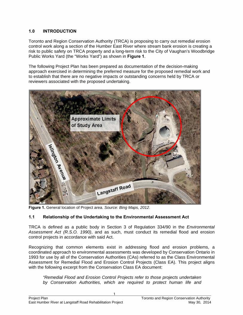
1.0 INTRODUCTION Toronto and Region Conservation Authority (TRCA) is proposing to carry out remedial erosion control work along a section of the Humber East River where stream bank erosion is creating a risk to public safety on TRCA property and a long-term risk to the City of Vaughan’s Woodbridge Public Works Yard (the “Works Yard”) as shown in Figure 1. The following Project Plan has been prepared as documentation of the decision-making approach exercised in determining the preferred measure for the proposed remedial work and to establish that there are no negative impacts or outstanding concerns held by TRCA or reviewers associated with the proposed undertaking.
Figure 1. General location of Project area. Source: Bing Maps, 2012. 1.1 Relationship of the Undertaking to the Environmental Assessment Act TRCA is defined as a public body in Section 3 of Regulation 334/90 in the Environmental Assessment Act (R.S.O. 1990), and as such, must conduct its remedial flood and erosion control projects in accordance with said Act. Recognizing that common elements exist in addressing flood and erosion problems, a coordinated approach to environmental assessments was developed by Conservation Ontario in 1993 for use by all of the Conservation Authorities (CAs) referred to as the Class Environmental Assessment for Remedial Flood and Erosion Control Projects (Class EA). This project aligns with the following excerpt from the Conservation Class EA document:
“Remedial Flood and Erosion Control Projects refer to those projects undertaken by Conservation Authorities, which are required to protect human life and
2 Project Plan Toronto and Region Conservation Authority East Humber River at Langstaff Road Rehabilitation Project May 30, 2014
property, in previously developed areas, from an impending flood or erosion problem. Such projects do not include works which facilitate or anticipate development. Major flood and erosion control undertakings which do not suit this definition, such as multipurpose projects, lie outside the limits of this Class require an Individual Environmental Assessment” (CO 2013).
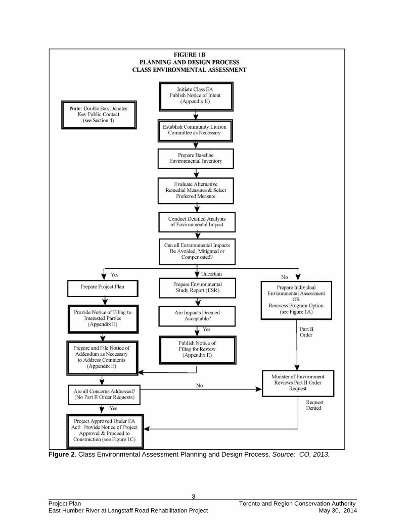
Almost twenty years of experience have demonstrated that using the Class EA approach is an effective way of complying with the EA Act’s requirements. Approval of the Class EA allows CAs to carry out these types of projects without applying for formal approval under the Act on the condition that all other necessary federal and provincial approvals are obtained (CO 2013). A chart illustrating the key steps of the Class EA planning and design process is shown below in Figure 2.
3 Project Plan Toronto and Region Conservation Authority East Humber River at Langstaff Road Rehabilitation Project May 30, 2014
Figure 2. Class Environmental Assessment Planning and Design Process. Source: CO, 2013.
4 Project Plan Toronto and Region Conservation Authority East Humber River at Langstaff Road Rehabilitation Project May 30, 2014
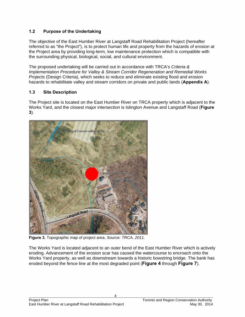
1.2 Purpose of the Undertaking The objective of the East Humber River at Langstaff Road Rehabilitation Project (hereafter referred to as “the Project”), is to protect human life and property from the hazards of erosion at the Project area by providing long-term, low maintenance protection which is compatible with the surrounding physical, biological, social, and cultural environment. The proposed undertaking will be carried out in accordance with TRCA’s Criteria & Implementation Procedure for Valley & Stream Corridor Regeneration and Remedial Works Projects (Design Criteria), which seeks to reduce and eliminate existing flood and erosion hazards to rehabilitate valley and stream corridors on private and public lands (Appendix A). 1.3 Site Description The Project site is located on the East Humber River on TRCA property which is adjacent to the Works Yard, and the closest major intersection is Islington Avenue and Langstaff Road (Figure 3).
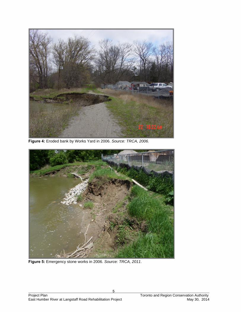
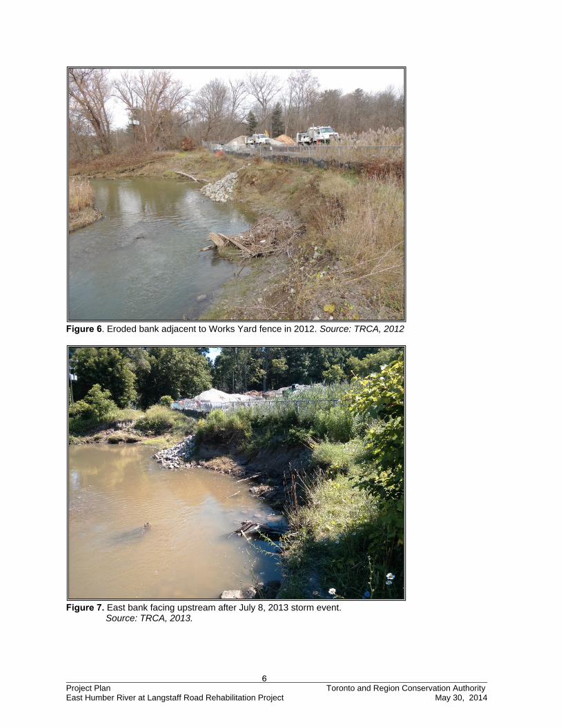
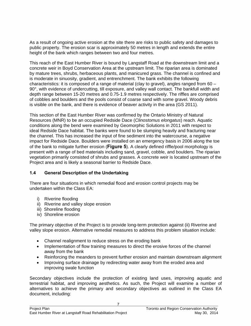
Figure 3. Topographic map of project area. Source: TRCA, 2011. The Works Yard is located adjacent to an outer bend of the East Humber River which is actively eroding. Advancement of the erosion scar has caused the watercourse to encroach onto the Works Yard property, as well as downstream towards a historic bowstring bridge. The bank has eroded beyond the fence line at the most degraded point (Figure 4 through Figure 7).
5 Project Plan Toronto and Region Conservation Authority East Humber River at Langstaff Road Rehabilitation Project May 30, 2014
Figure 4: Eroded bank by Works Yard in 2006. Source: TRCA, 2006.
Figure 5: Emergency stone works in 2006. Source: TRCA, 2011.
6 Project Plan Toronto and Region Conservation Authority East Humber River at Langstaff Road Rehabilitation Project May 30, 2014
Figure 6. Eroded bank adjacent to Works Yard fence in 2012. Source: TRCA, 2012
Figure 7. East bank facing upstream after July 8, 2013 storm event.
Source: TRCA, 2013.
7 Project Plan Toronto and Region Conservation Authority East Humber River at Langstaff Road Rehabilitation Project May 30, 2014
As a result of ongoing active erosion at the site there are risks to public safety and damages to public property. The erosion scar is approximately 50 metres in length and extends the entire height of the bank which ranges between two and four metres.
This reach of the East Humber River is bound by Langstaff Road at the downstream limit and a concrete weir in Boyd Conservation Area at the upstream limit. The riparian area is dominated by mature trees, shrubs, herbaceous plants, and manicured grass. The channel is confined and is moderate in sinuosity, gradient, and entrenchment. The bank exhibits the following characteristics: it is composed of a range of material (clay to gravel), angles ranged from 60 – 90°, with evidence of undercutting, till exposure, and valley wall contact. The bankfull width and depth range between 15-20 metres and 0.75-1.9 metres respectively. The riffles are comprised of cobbles and boulders and the pools consist of coarse sand with some gravel. Woody debris is visible on the bank, and there is evidence of beaver activity in the area (GS 2011). This section of the East Humber River was confirmed by the Ontario Ministry of Natural Resources (MNR) to be an occupied Redside Dace (Clinostomus elongatus) reach. Aquatic conditions along the bend were examined by Geomorphic Solutions in 2011 with respect to ideal Redside Dace habitat. The banks were found to be slumping heavily and fracturing near the channel. This has increased the input of fine sediment into the watercourse, a negative impact for Redside Dace. Boulders were installed on an emergency basis in 2006 along the toe of the bank to mitigate further erosion (Figure 5). A clearly defined riffle/pool morphology is present with a range of bed materials including sand, gravel, cobble, and boulders. The riparian vegetation primarily consisted of shrubs and grasses. A concrete weir is located upstream of the Project area and is likely a seasonal barrier to Redside Dace. 1.4 General Description of the Undertaking There are four situations in which remedial flood and erosion control projects may be undertaken within the Class EA:
i) Riverine flooding ii) Riverine and valley slope erosion iii) Shoreline flooding iv) Shoreline erosion
The primary objective of the Project is to provide long-term protection against (ii) Riverine and valley slope erosion. Alternative remedial measures to address this problem situation include:
Channel realignment to reduce stress on the eroding bank Implementation of flow training measures to direct the erosive forces of the channel
away from the bank Reinforcing the meanders to prevent further erosion and maintain downstream alignment Improving surface drainage by redirecting water away from the eroded area and
improving swale function Secondary objectives include the protection of existing land uses, improving aquatic and terrestrial habitat, and improving aesthetics. As such, the Project will examine a number of alternatives to achieve the primary and secondary objectives as outlined in the Class EA document, including:
8 Project Plan Toronto and Region Conservation Authority East Humber River at Langstaff Road Rehabilitation Project May 30, 2014
Local armouring without channel infilling Local armouring and downstream protection without channel infilling Minor realignment
In accordance with the Class EA planning process, a full range of alternatives must be developed, including both traditional and innovative approaches. The type and range of alternatives developed, such as the ones listed above, will vary by project as they are based on the nature, cause and extent of the problem. The options developed must be tailored to the individual characteristics of each site. The decision-making process used in the selection of the preferred remedial solution is documented in detail in Section 4.0. In determining the preferred method of remediation for the erosion and slope instability problem, two major factors were considered: risk to structure(s); and the cause(s) of the hazard. According to TRCA’s Design Criteria, potential risk to existing structures is deemed to be the most important factor and accordingly is given more weight than the physical and geological condition associated with the cause of erosion and/or instability. In all cases, the design of erosion control and slope stabilization works must provide protection compatible with TRCA’s Design Criteria, which includes improvements to or enhancements of the existing terrestrial and aquatic habitat conditions through natural designs. The proposed undertaking meets all TRCA planning and policy objectives, and satisfies the needs and concerns of the affected property owners and general public. 1.5 Rationale for Undertaking In 2010, TRCA retained Geomorphic Solutions (A Member of The Sernas Group Inc.) to complete a geomorphic assessment of the Project area. As part of this investigation, TRCA requested recommendations and preliminary design concepts to address erosion concerns at the Project area. The assessment identified that there was a risk to the Works Yard and that remedial works would be required to stabilize and provide long-term stability to the area. As part of the initial planning for the Class EA for this site, TRCA evaluated the “Do Nothing” option which assesses what would happen on site if left in its existing state. The results of the assessment indicated a high likelihood for a substantial loss of valuable table land, ongoing risk to life and property, and ongoing degradation of aquatic habitat due to sediment and other deleterious inputs from the active bank erosion encroaching into the paved parking area at the top of bank. This analysis illustrates an overall net benefit to undertake remedial works on site. It is for this reason that TRCA made the determination to proceed with the Class EA. 2.0 BACKGROUND This section provides factual information as to the causes, effects, extent and associated hazards relating to erosion and instability at the Project area. The findings and recommendations of previous studies are presented herein as justification for TRCA’s involvement. 2.1 History of the Problem
9 Project Plan Toronto and Region Conservation Authority East Humber River at Langstaff Road Rehabilitation Project May 30, 2014
The erosion problem along this section of the East Humber River was first identified to TRCA in 2004 when the City of Vaughan staff expressed concern over the close proximity of the erosion scar to their property. Following a visual inspection by TRCA staff, it was recommended that remedial works be undertaken to repair the scar; however, no funding was secured and the erosion continued unabated. In January 2006, staff at the City of Vaughan again contacted the TRCA. They stated that the erosion had rapidly accelerated since the August 19th, 2005 storm event. As a result of the increasing erosion, TRCA carried out emergency works to prevent the erosion from encroaching onto the parking lot of the Works Yard. As part of the permit granted to TRCA by MNR, TRCA had to complete a geomorphic study and EA to permanently address the issue. However, due to funding issues, the work was postponed until 2010. TRCA retained Geomorphic Solutions to conduct a geomorphic assessment and erosion risk analysis of the Project area in late 2010. Geomorphic Solutions reported that the erosion was likely triggered by the straightening of the channel between 1960 and 1966. This shifted the channel thalweg significantly changing the meander form of the river resulting in increased lateral migration through the Project area. As a result of this migration, the erosive forces of the river have been directed towards the Works Yard and the historic bridge downstream. On Friday, July 29, 2011 at Toronto and Region Conservation Authority meeting #7/11, Resolution #A155/11 was ratified to commence the Class EA process for this project. The Class EA officially commenced on May 30, 2012 with the distribution of the Notice of Intent (NOI) to the identified stakeholder list and publication of the NOI in Vaughan Weekly.
10 Project Plan Toronto and Region Conservation Authority East Humber River at Langstaff Road Rehabilitation Project May 30, 2014
2.2 Identification of Previous Studies 2.2.1 Geomorphic Assessments Geomorphic Solutions (2011) – East Humber River at Langstaff Road Geomorphic Assessment and Erosion Risk Analysis The primary purpose of this study was to assess and determine the systematic adjustments of the channel within the Project area, quantify erosion rates, evaluate existing aquatic habitat with particular attention given to Redside Dace, and to develop conceptual design alternatives. The erosion appears to be due to the straightening of the channel upstream of the Works Yard. This altered the location of the channel thalweg which subsequently shifted the meander form of the river. The lateral channel migration rate was determined to be 0.16 m/yr from 1946 to 2009, and between 2005 and 2009 the rate accelerated to 0.70 m/yr. It is projected that the channel will continue to migrate towards the Works Yard thereby putting it at risk. Aquatic habitat was found to be negatively impacted by the increased input of fines into the watercourse. 2.2.2 Planning Documents The Project area has received extensive scrutiny at all levels of government as part of the planning process. In developing the range of alternatives for evaluation under the Class EA guidelines, TRCA incorporated many of the planning recommendations from the municipal, provincial and federal governments into the study. Greenspace Strategy (1989) TRCA completed the Greenspace Strategy (the strategy) for the Greater Toronto Region, a strategic planning exercise to establish long-term goals for the management of greenspace within the Authority’s jurisdiction. The strategy provided direction for the conservation of the Lake Ontario waterfront, the river valleys, and the Oak Ridges Moraine and identified the need for greater cooperation to achieve more integrated natural resource planning and management. It proposed that the TRCA establish a planning task force for each major watershed and for the Lake Ontario waterfront within the TRCA’s jurisdiction. As per the strategy, a watershed is defined as the total area of land drained by a watercourse and its tributaries. The objective of the strategy is to provide direction on natural systems protection, restoration, public education, recreation, and cultural and heritage planning activities within a watershed. To date, TRCA has established planning task forces and completed watershed management strategies for three of the nine watersheds within its jurisdiction. In 1990, TRCA adopted the Comprehensive Basin Management Strategy for the Rouge River Watershed, the first watershed management strategy. Forty Steps to a New Don was published by the Don Watershed Task Force in 1994, and in 1997 Legacy: A Strategy for a Healthy Humber and A Call To Action were published as an integrated watershed management strategy for the Humber River (TRCA 1999). Valley and Stream Corridor Management Program (1994) The Valley and Stream Corridor Management Program (the Program) is a guideline document developed by TRCA to direct land use activities and development within valley and stream corridors. The Program acknowledges the need for risk management related to flooding, erosion, slope instability, while ensuring that future environmental degradation is prevented, and natural areas are restored. This Program includes policies and criteria that govern any change to existing resource-based uses of valley and stream corridors. The Program also offers recommendations for the rehabilitation of valley and stream corridors that help to direct short and long-term resource planning activities.
11 Project Plan Toronto and Region Conservation Authority East Humber River at Langstaff Road Rehabilitation Project May 30, 2014
Toronto and Region Remedial Action Plan (1994) The Toronto and Region Remedial Action Plan (RAP) was developed by all levels of government and other stakeholders. RAP encompasses 2,000 km2 within TRCA’s jurisdiction in the City of Toronto for areas of concern. These areas include the Lake Ontario Waterfront and all the watersheds between Etobicoke Creek in the west and Rouge River in the east. The RAP Team consists of Environment Canada, Ontario Ministry of Natural Resources and TRCA. RAP works towards the following goals:
Clean waters Healthy Habitats Science and Monitoring Sustainability Education and Involvement
Terrestrial Natural Heritage System Strategy (2006) TRCA’s Terrestrial Natural Heritage System Strategy (TNHSS) was designed to enhance biodiversity and the quality of life for residents by increasing the amount of forest and wetland habitats. It uses a science-based analytical tool based on ecological criteria to identify an expanded and targeted land base for inclusion in a terrestrial natural heritage system. TNHSS was designed for the entire TRCA jurisdiction as terrestrial systems and their interactions span watershed boundaries. The target system relates to the terrestrial component of the natural heritage system. Although increases in natural cover may benefit many other system components, the target terrestrial natural heritage system was designed using terrestrial ecological criteria. TNHSS contains a number of strategic directions including proposed land use planning policies, land management, stewardship and education opportunities, and long-term monitoring. 2.2.3 Aquatic and Terrestrial Habitat Reports In the past twenty years, management plans have been developed to preserve and improve the aquatic and terrestrial conditions along the Humber River watershed. The Humber River watershed is the largest in TRCA’s jurisdiction encompassing 903 km2 and home to 732,000 people. This Class EA incorporates a number of studies completed over the last thirty years in order to provide a broad understanding of the environmental conditions within the Humber River watershed. The following sources of information are only several of the resources that were used to define the aquatic and terrestrial conditions for the Project area:
CFN# 46261: East Humber River at Langstaff Road Erosion Control Project, TRCA Corporate Records.
Environment Canada, Ministry of the Environment, Ministry of Natural Resources, Toronto and Region Conservation Authority.1989. Metro Toronto and Region Remedial Action Plan. Stage 1. Environmental Conditions and Problem Definition.
Toronto and Region Conservation Authority (TRCA). 1982. Environmentally Significant Areas Study.
Government of Canada. Committee on the Status of Endangered Wildlife in Canada (COSEWIC). 2009. Retrieved December 1 2009. (www.cosewic.gc.ca).
12 Project Plan Toronto and Region Conservation Authority East Humber River at Langstaff Road Rehabilitation Project May 30, 2014
Terrestrial and aquatic data were obtained by TRCA. Data from these inventories were referenced in this report where applicable. 2.2.4 Socioeconomic and Cultural Heritage Studies The following sources of information were used to define the socioeconomic conditions and cultural heritage resources for the Project area:
Toronto and Region Conservation Authority. 2012. Archaeology Department. Roots, B., Chant, D.A. and Heidenreich, C.1999. Special Places: The Changing
Ecosystems of the Toronto Region. York Region Transit / Viva (YRT) website. 2012. Bus Routes, 10 York-U Woodbridge.
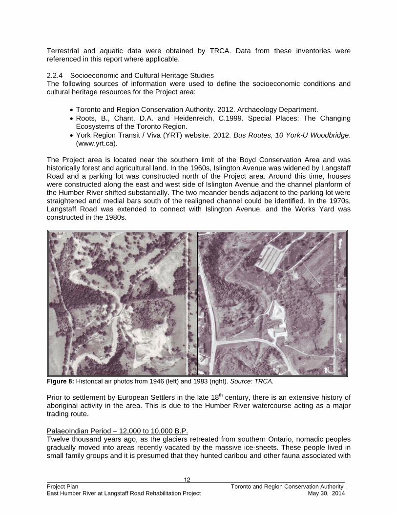
(www.yrt.ca). The Project area is located near the southern limit of the Boyd Conservation Area and was historically forest and agricultural land. In the 1960s, Islington Avenue was widened by Langstaff Road and a parking lot was constructed north of the Project area. Around this time, houses were constructed along the east and west side of Islington Avenue and the channel planform of the Humber River shifted substantially. The two meander bends adjacent to the parking lot were straightened and medial bars south of the realigned channel could be identified. In the 1970s, Langstaff Road was extended to connect with Islington Avenue, and the Works Yard was constructed in the 1980s.
Figure 8: Historical air photos from 1946 (left) and 1983 (right). Source: TRCA. Prior to settlement by European Settlers in the late 18th century, there is an extensive history of aboriginal activity in the area. This is due to the Humber River watercourse acting as a major trading route. PalaeoIndian Period – 12,000 to 10,000 B.P. Twelve thousand years ago, as the glaciers retreated from southern Ontario, nomadic peoples gradually moved into areas recently vacated by the massive ice-sheets. These people lived in small family groups and it is presumed that they hunted caribou and other fauna associated with
13 Project Plan Toronto and Region Conservation Authority East Humber River at Langstaff Road Rehabilitation Project May 30, 2014
the cooler environment of this time period. It should be remembered that as the glaciers melted at the end of the last ice age, the landscape of southern Ontario was very much like the tundra of the present day eastern sub-arctic. Traditionally, the PalaeoIndian occupation of southern Ontario has been associated with glacial lake shorelines, however recent investigations in the Toronto vicinity indicate that these peoples also exploited interior locations situated inland from the glacial lakes. Archaic Period – 10,000 to 2800 B.P. As the climate in southern Ontario warmed, Aboriginal populations adapted to these new environments and associated fauna. Thus, many new technologies and subsistence strategies were introduced and developed by the Archaic peoples of this time period. Woodworking implements such as groundstone axes, adzes and gouges began to appear, as did net-sinkers (for fishing), numerous types of spear points and items made from native copper, which was mined from the Lake Superior region. The presence of native copper on archaeological sites in southern Ontario and adjacent areas suggests that Archaic groups were involved in long range exchange and interaction. The trade networks established at this time were to persist between Aboriginal groups until European contact. To harvest the new riches of the warming climate, the Archaic bands of southern Ontario followed an annual cycle, which exploited seasonally available resources in differing geographic locales within watersheds. As the seasons changed, these bands split into smaller groups and moved inland to exploit other resources that were available during the fall and winter such as deer, rabbit, squirrel and bear, which thrived in the forested margins of these areas. Initial Woodland Period – approximately 1000 B.C. (3000/2800 B.P.) to A.D. 700 Early in the Initial Woodland period, band size and subsistence activities were generally consistent with the groups of the preceding Archaic Period. Associated with the earliest components of this cultural period is the introduction of clay pots. Additionally, around two thousand years ago a revolutionary new technology, the bow and arrow, was brought into southern Ontario and radically changed the approach to hunting and warfare. These two technological innovations allowed for major changes in subsistence and settlement patterns. As populations became larger, camps and villages with more permanent structures were occupied longer and more consistently. Generally, these larger sites are associated with the gathering of macrobands. Often these larger groups would reside in favourable locations to cooperatively take advantage of readily exploitable resources. It was also during this period that elaborate burial rituals and the interment of numerous exotic grave goods with the deceased began to take place. Increased trade and interaction between southern Ontario populations and groups as far away as the Atlantic coast and the Ohio Valley was also taking place. Late Woodland Period – A.D. 700 to 1650 Around A.D. 700, maize was introduced into southern Ontario from the south. With the development of horticulture as the predominant subsistence base, the Late Woodland Period gave rise to a tremendous population increase and the establishment of permanent villages. These villages consisted of longhouses measuring six metres wide and high and extending anywhere from three to 15 metres in length. Quite often these villages, some of which are one to four hectares in size, were surrounded by multiple rows of palisades suggesting that defence was a community concern. Aside from villages, Late Woodland peoples also inhabited hamlets and special purpose cabins and campsites that are thought to have been associated with larger settlements. Social changes were also taking place, as reflected in the fluorescence of smoking pipes; certain burial rituals, including community burials in ossuaries; increased settlement size; and distinct clustering of both longhouses within villages (clan development) and villages within a region (tribal development). One interesting socio-cultural phenomenon that occurred during
14 Project Plan Toronto and Region Conservation Authority East Humber River at Langstaff Road Rehabilitation Project May 30, 2014
this period as a result of the shift in emphasis from hunting to horticulture was a movement away from the traditional patrilineal and patrilocal societies of the preceding band-oriented groups to a matrilineal orientation. According to oral traditions, Anishinaabe peoples migrated from the Eastern coast into the Great Lakes region around 1400. Living on the Canadian Shield, these groups remained largely nomadic well into the Historic or EuroCanadian Period. The Late Woodland groups that inhabited the Toronto area eventually moved their villages northward toward Georgian Bay. It was these and other groups in southwest Ontario that eventually evolved into the Aboriginal nations who interacted with and were described by French missionaries and explorers during the early seventeenth century. Post Contact Period – 1650 to 1805 Also called the Early Historic Period, these years are characterized by the arrival of a small number of Europeans interested in exploration, trade, and establishing missions, coupled with a gradual adoption of European materials by First Nations peoples. In terms of material culture, it is often difficult to distinguish between Haudenosaunee, Anishinaabe, Métis and colonial settler campsites during these early years. This is due to the interaction and adoption of each of the others’ material goods and subsistence strategies which blur cultural boundaries. Such interaction was essential to early explorers and missionaries who relied on local people for survival strategies and knowledge of the local landscape. These permeable boundaries continued until the Crown established segregated reserves in the eighteenth and early nineteenth centuries for the Haudenosaunee and Anishinaabe communities who remained here while granting properties to European settlers. EuroCanadian Period –1787 to Present (York County) York County The land known as York County was initially purchased by the British in 1783 from the Mississauga people and became the Province of Upper Canada in 1791 (Reaman, 1971). One year later, the first lieutenant-governor, Colonel John Graves Simcoe formed 19 counties, including York County (Reaman, 1971) which originally comprised modern day York Region, Peel Region, Halton Region, Toronto, parts of Durham Region and the City of Hamilton. Eleven townships formed York County and these included, East Gwillimbury, East York, Etobicoke, Georgina, King, Markham, North Gwillimbury, North York, Scarborough, Vaughan, Whitchurch and York (Reaman, 1971). “Simcoe made every effort to give English names to countries, towns, townships and rivers, in order to impress on the Loyalists that there was a continuing British presence north of the lost American Colonies” (Rayburn, 1996). Townships that were further inland were not a desirable settlement location for the Loyalists and were therefore of secondary importance to the settlement policies of Simcoe. As a result, the prime waterfront townships were quickly occupied by the Loyalists, while other townships were left for the children of Loyalists, “late-Loyalists” and settlers from Europe and the United States to clear. Vaughan Township The West Riding of York County included Vaughan Township. After the Districts were abolished in May 1849, the area remained as part of the County of York. When the County of York was dissolved in 1971 and replaced by the Regional Municipality of York the northern boundary of Vaughan Township was moved north one lot into King Township. Vaughan Township together with the Village of Woodbridge became the Town of Vaughan and then in 1971 the City of Vaughan. The first survey of Vaughan Township was begun in 1795 by Surveyor Tredell. It was not until 1851 that the survey was finally completed by others. The township was laid out in eleven
15 Project Plan Toronto and Region Conservation Authority East Humber River at Langstaff Road Rehabilitation Project May 30, 2014
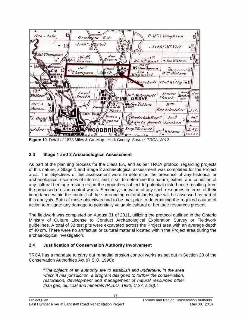
concessions one and one quarter miles apart, running north and south from Yonge Street to the western boundary of York Region and was divided by six sideroads also one and one quarter miles apart running east and west. Each concession was divided into 200 acre lots with five lots between every sideroad. Thus, a lot and concession referred to a 200 acre parcel of land defined by the concession road on its western boundary. In 1799, the first European settlers were granted lands along Yonge Street. The community was originally named Windham, after William Windham the Secretary at War, who was a supporter and organizer of the colonization of the new British territory. The area was also known as Puisaye town after the colourful leader, the Comte de Puisaye who led the first wave of French Royalists into the area in 1798. Joseph-Genevieve, Comte de Puisaye and his followers were mostly from French noble families, who had fled during the French revolution and were living in exile in England at the time. The township was eventually named by Simcoe in honour of the British diplomat Benjamin Vaughan. Vaughan was a co-negotiator of the Peace of Paris, which was the treaty that ended the American Revolutionary War. There were many concerns expressed at the time that these French Loyalists would not be able to handle the harsh pioneering conditions, as they were mostly aristocrats who would struggle in such harsh and rustic conditions. It was not long after they arrived before these concerns were justified as the task of clearing lands, building log cabins and planting crops soon became a cruel reality. French and British settlers initially lived in barrack style housing while the land was cleared and the village established. Within the first year, many of the colonists deserted to places like York, New York and Montreal. Those who stayed behind would have to wait seven years before they would legally own their land. When they finally did receive ownership, they often sold it and returned to Europe. Lot 12 Concession VII Tremaine’s 1860 map (Figure 9) divides Lot 12 Concession VII, east from west, into two equal-sized parcels of land. The western parcel is registered to an N. Shaver, with no structures listed on the property. The eastern parcel of land is registered to an S. Smith. The East Humber River runs, north to south, through the eastern parcel of Lot 12 Concession VII. To the east of the river is the proposed Humber River Canal project. There is also an unmarked road running through the western end of the property belonging to S. Smith. The only structure that appears on Smith’s parcel is a saw mill situated on the eastern side of the East Humber River along a small tributary. Miles and Company’s 1878 Atlas (Figure 10) divides Lot 12 Concession VII into two equal-sized parcels of land. The western parcel is registered to a James Thompson, with a single structure and associated orchard near the western edge of the property. The eastern parcel of land remains registered to the Samuel Smith that appears on the 1860 map. The unmarked road running through the eastern parcel on Tremaine’s 1860 map is listed on the 1878 atlas; however, there is another road running southwest to northeast through the eastern half of Smith’s property. The saw mill remains on Smith’s property, at the southern end of a mill pond built along the East Humber River. No structures are listed on either map within the Project area. It is possible that previously undocumented structures may be encountered within the current project area relating to nineteenth century residential, industrial and agricultural activity areas. It should be stressed
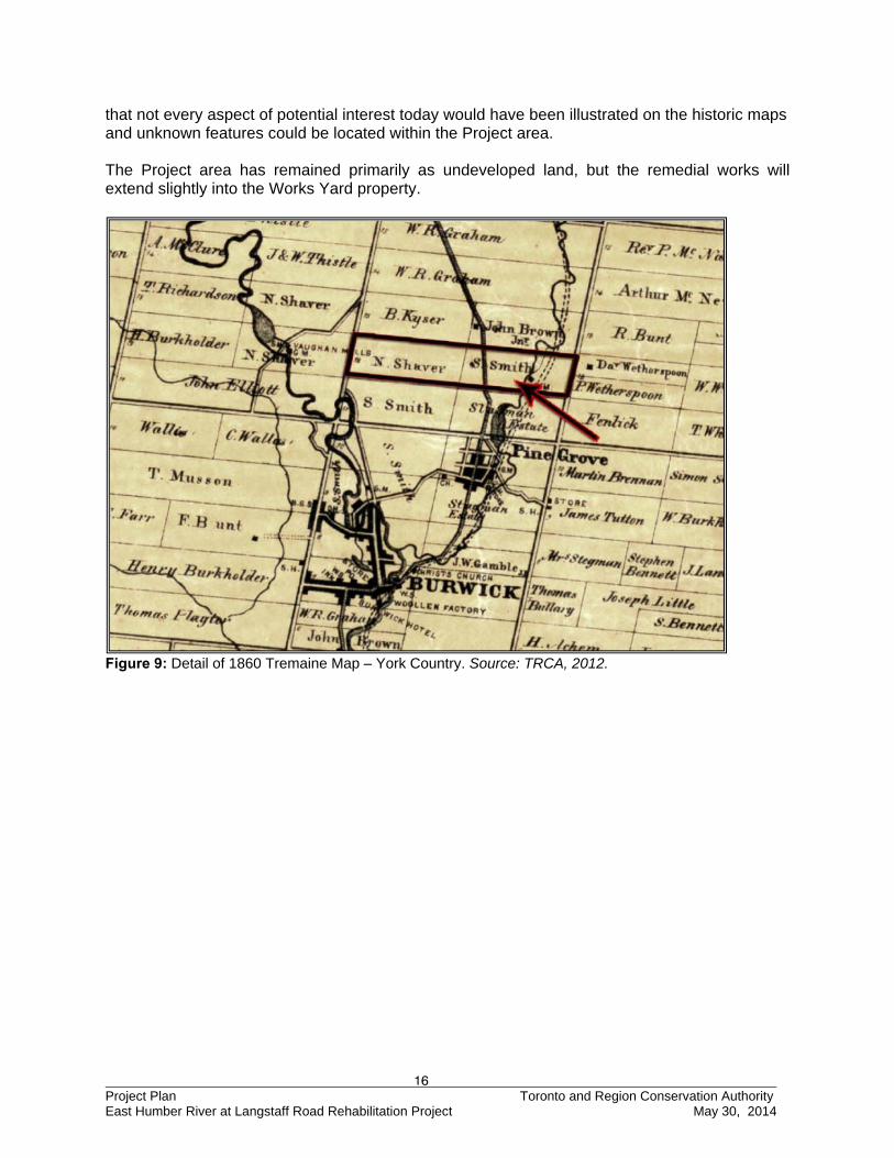
16 Project Plan Toronto and Region Conservation Authority East Humber River at Langstaff Road Rehabilitation Project May 30, 2014
that not every aspect of potential interest today would have been illustrated on the historic maps and unknown features could be located within the Project area. The Project area has remained primarily as undeveloped land, but the remedial works will extend slightly into the Works Yard property.
Figure 9: Detail of 1860 Tremaine Map – York Country. Source: TRCA, 2012.
17 Project Plan Toronto and Region Conservation Authority East Humber River at Langstaff Road Rehabilitation Project May 30, 2014
Figure 10: Detail of 1878 Miles & Co. Map - York County. Source: TRCA, 2012.
2.3 Stage 1 and 2 Archaeological Assessment
As part of the planning process for the Class EA, and as per TRCA protocol regarding projects of this nature, a Stage 1 and Stage 2 archaeological assessment was completed for the Project area. The objectives of this assessment were to determine the presence of any historical or archaeological resources of interest, and, if so, to determine the nature, extent, and condition of any cultural heritage resources on the properties subject to potential disturbance resulting from the proposed erosion control works. Secondly, the value of any such resources in terms of their importance within the context of the surrounding cultural landscape will be assessed as part of this analysis. Both of these objectives had to be met prior to determining the required course of action to mitigate any damage to potentially valuable cultural or heritage resources present. The fieldwork was completed on August 31 of 2011, utilizing the protocol outlined in the Ontario Ministry of Culture License to Conduct Archaeological Exploration Survey or Fieldwork guidelines. A total of 32 test pits were excavated across the Project area with an average depth of 40 cm. There were no artifactual or cultural material located within the Project area during the archaeological investigation.
2.4 Justification of Conservation Authority Involvement
TRCA has a mandate to carry out remedial erosion control works as set out in Section 20 of the Conservation Authorities Act (R.S.O. 1990):
“The objects of an authority are to establish and undertake, in the area which it has jurisdiction, a program designed to further the conservation, restoration, development and management of natural resources other than gas, oil, coal and minerals (R.S.O. 1990, C.27, s.20).”
18 Project Plan Toronto and Region Conservation Authority East Humber River at Langstaff Road Rehabilitation Project May 30, 2014
As part of this broad mandate, CAs are considered to have prime responsibility over water management in terms of water quantity and related hazards through administrative and regulatory powers. In the 1980 Watershed Plan, TRCA developed and implemented its Erosion and Sediment Control Program (ESCP) with two major directions: “To minimize the aggravation or creation of erosion or sediment
problems as a result of new development, and to rectify existing problems through protective works” (TRCA, 1980).
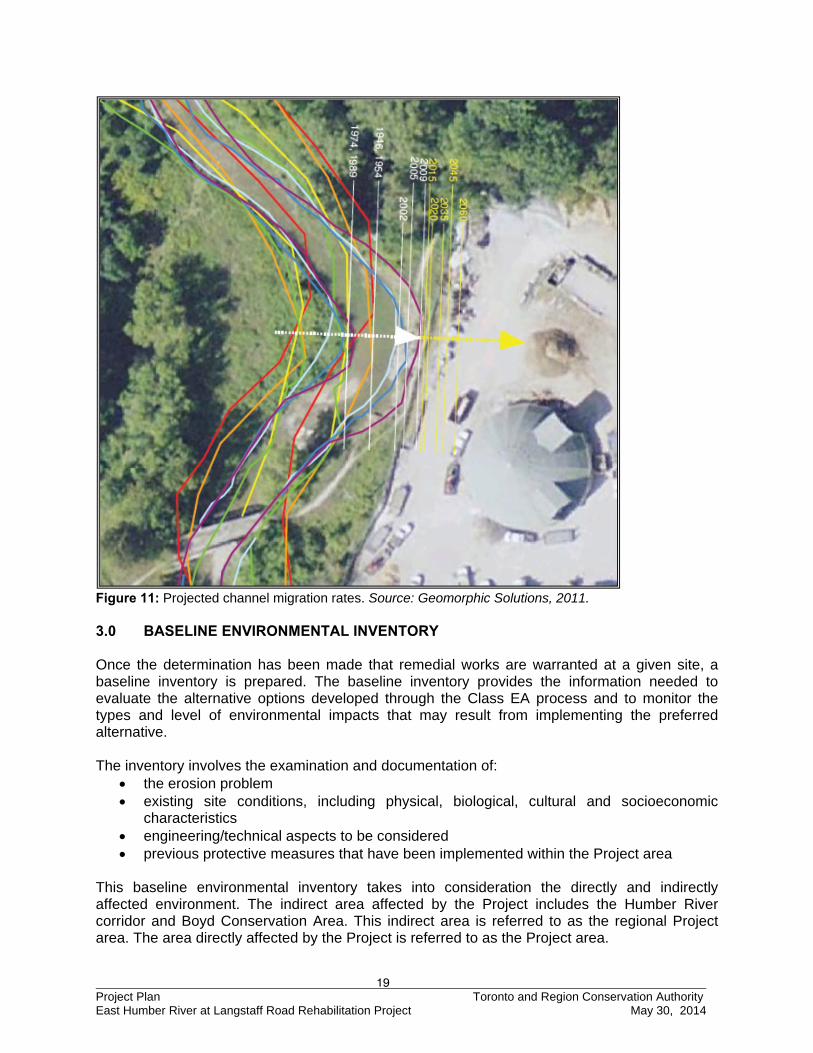
These directions are categorized as either preventative, or protective, respectively. The Project falls under the protection component of the ESCP, which is designed to protect lives and minimize loss of property through the construction of suitable remedial works. Through annual capital funding from the Region of York, TRCA is able to implement a program of major remedial works for slope stabilization throughout the watersheds of York Region. TRCA strives to prevent, eliminate or reduce the risk of hazard to life and property, and to protect and enhance the natural attributes along the Metropolitan, Lake Ontario shoreline and the primary river valleys within Metropolitan Toronto. The results of the geomorphic assessment carried out by Geomorphic Solutions (2011) as described in Section 2.2 indicate that the meander will continue to migrate towards the Works Yard if remedial action is not taken. The extent to which the channel is expected to migrate is identified by the projected meander width assessment for up to 2060 and can be seen in Figure 11 below. If left unabated, the Works Yard will continue to lose property and the bank will erode further depositing fines into the Humber River justifying the need for remedial works.
19 Project Plan Toronto and Region Conservation Authority East Humber River at Langstaff Road Rehabilitation Project May 30, 2014
Figure 11: Projected channel migration rates. Source: Geomorphic Solutions, 2011. 3.0 BASELINE ENVIRONMENTAL INVENTORY Once the determination has been made that remedial works are warranted at a given site, a baseline inventory is prepared. The baseline inventory provides the information needed to evaluate the alternative options developed through the Class EA process and to monitor the types and level of environmental impacts that may result from implementing the preferred alternative. The inventory involves the examination and documentation of:
the erosion problem existing site conditions, including physical, biological, cultural and socioeconomic
characteristics engineering/technical aspects to be considered previous protective measures that have been implemented within the Project area
This baseline environmental inventory takes into consideration the directly and indirectly affected environment. The indirect area affected by the Project includes the Humber River corridor and Boyd Conservation Area. This indirect area is referred to as the regional Project area. The area directly affected by the Project is referred to as the Project area.
20 Project Plan Toronto and Region Conservation Authority East Humber River at Langstaff Road Rehabilitation Project May 30, 2014
Baseline environmental data were collected from the following organizations due to their specific expertise relevant to the regional and local Project area:
Environment Canada Ontario Ministry of Natural Resources Ontario Ministry of the Environment Toronto and Region Conservation Authority
To assist with the review and expansion of the baseline inventory as well as the design of the preferred alternative, TRCA retained the services of the fluvial geomorphology firm Geomorphic Solutions in 2011 which is now referred to as GHD. 3.1 Existing Site Conditions In accordance with the Class EA process, the broad definition of ‘environment’ as provided in the Environmental Assessment Act is applied to this section. The prepared environmental description is “an inventory of elements for which a given project is likely to have an impact” (CO 2013). The inventory includes an evaluation of the presence and extent of physical, biological, cultural, social, economic, and technical engineering elements applicable to the Project area. A drawing of the existing site conditions for the Project area is in Appendix D. 3.1.1 Physical Environment Unique Landforms There are no unique landforms within the Project area. Existing Mineral/Aggregated Resource Extraction Industries There are no existing mineral/aggregate resource extraction industries within the Project area. Earth Science – Areas of Natural and Scientific Interest (ANSI) There are no Earth Science Areas of Natural Scientific Interest (ANSI-ES) within the Project area. Specialty Crop Area /Agricultural Lands or Production There are no specialty crop areas or agricultural lands within the Project area. Niagara Escarpment/Oak Ridges Moraine The Project area is not located in the Niagara Escarpment or the Oak Ridges Moraine. Environmentally Significant Areas (ESA) – Physical There are no physical Environmentally Significant Areas (ESAs) within the Project area. Air Quality The Project area is located to the North of Toronto, but the closest air quality station is Toronto West. The Project area experiences similar air quality conditions found throughout the Toronto region as a result of urbanization and industrial development in Southern Ontario. Atmospheric pollutants that are sampled on an hourly basis in the Toronto area include carbon monoxide
21 Project Plan Toronto and Region Conservation Authority East Humber River at Langstaff Road Rehabilitation Project May 30, 2014
(CO), nitrogen dioxide (NO2), ground level ozone (O3), sulphur dioxide (SO2), suspended particulates, and total reduced sulphur compounds (AQO 2013).
The Air Quality Index (AQI) is an indicator of air quality based on hourly pollutant measurements of some or all of the six most common air pollutants listed above. The AQI is used to inform Toronto residents of the existing air quality and to provide health advisories when the combined levels of the pollutants exceed certain levels of the index. If the air quality value is below 32, the air quality is considered relatively good. If the AQI value is in the range of 32 to 49 (moderate category), there may be some adverse effects on very sensitive people. An index value in the 50 to 99 range (poor category) may have some short-term adverse effects on human or animal populations or may cause significant damage to vegetation and property. An AQI value of 100 or more (very poor category) may cause adverse effects on a large proportion of those exposed (AQO 2013).
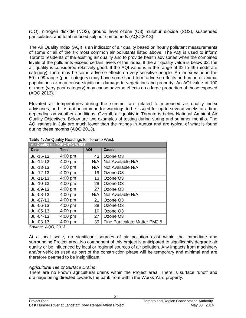
Elevated air temperatures during the summer are related to increased air quality index advisories, and it is not uncommon for warnings to be issued for up to several weeks at a time depending on weather conditions. Overall, air quality in Toronto is below National Ambient Air Quality Objectives. Below are two examples of testing during spring and summer months. The AQI ratings in July are much lower than the ratings in August and are typical of what is found during these months (AQO 2013).
Table 1: Air Quality Readings for Toronto West. Air Quality for TORONTO WEST Date Time AQI Cause
Jul-15-13 4:00 pm 43 Ozone O3 Jul-14-13 4:00 pm N/A Not Available N/A Jul-13-13 4:00 pm N/A Not Available N/A Jul-12-13 4:00 pm 19 Ozone O3 Jul-11-13 4:00 pm 13 Ozone O3 Jul-10-13 4:00 pm 29 Ozone O3 Jul-09-13 4:00 pm 27 Ozone O3 Jul-08-13 4:00 pm N/A Not Available N/A Jul-07-13 4:00 pm 21 Ozone O3 Jul-06-13 4:00 pm 38 Ozone O3 Jul-05-13 4:00 pm 10 Ozone O3 Jul-04-13 4:00 pm 27 Ozone O3 Jul-03-13 4:00 pm 39 Fine Particulate Matter PM2.5
Source: AQO, 2013. At a local scale, no significant sources of air pollution exist within the immediate and surrounding Project area. No component of this project is anticipated to significantly degrade air quality or be influenced by local or regional sources of air pollution. Any impacts from machinery and/or vehicles used as part of the construction phase will be temporary and minimal and are therefore deemed to be insignificant. Agricultural Tile or Surface Drains There are no known agricultural drains within the Project area. There is surface runoff and drainage being directed towards the bank from within the Works Yard property.
22 Project Plan Toronto and Region Conservation Authority East Humber River at Langstaff Road Rehabilitation Project May 30, 2014
Noise Levels and Vibration The Project area is located within parkland/forest and adjacent to a public Works Yard. As such, most noise within the Project area is typically associated with equipment and large vehicle operation and vehicular traffic on Langstaff Road. Water Flow Regime (High / Base and Low / Base) As with most southern Ontario watercourses, flows in the Humber River typically peak in March and April in response to the spring freshet. Please reference Appendix B for a table that summarizes the water surface elevations, flows, and channel velocity for cross-sections located around the Project area. Existing Surface Drainage / Groundwater Seepage /Groundwater Recharge and Discharge Zones There is evidence of surface runoff from the Works Yard contributing to erosion of the bank adjacent to the Works Yard. Groundwater conditions at the site were not observed to be a contributing erosive factor as per the Geomorphic Solutions (2011) investigation, and the work will not impact groundwater discharge or recharge zones. Littoral Drift/Other Coastal Processes As the project site is located within a riverine setting, littoral drift or other coastal processes are not applicable. Water Quality The Humber River has similar water quality to the other watersheds in the Toronto region as a result of urbanization. Pesticides, polychlorinated biphenyls (PCBs), polynuclear aromatic hydrocarbons (PAHs), phosphorous, nitrogen compounds, and suspended sediment are among some of the common pollutants found within this urban waterbody. The eroding banks at the Project area act as a consistent source of fine sediment input into the Humber River increasing the overall turbidity. Soil/Fill Quality The bedrock of the Humber River Watershed consists of interbedded limestone and shale from the Georgian Bay Formation. Quaternary glacial sediments within the Project area consist of glacial and interglacial deposits formed within the last 135,000 years. The upper surficial geologic unit of the Humber River at Langstaff Avenue is dominated by compact clay and silt till with sand diamicton from the Halton Till Formation. The upper-most geologic unit overlying the Halton Till is comprised of clays, silts and sands deposited by Glacial Lake Iroquois. The channel flows through fluvial deposits consisting of sand, gravel and cobbles (TRCA, 2008). Contaminated Soils/Sediment/Seeps There are no known contaminated soils, sediments, or seeps within the Project area; however, no sampling has been conducted to date. Existing Transportation Routes The main transportation routes surrounding the Project area are Langstaff Road to the south and Islington Avenue to the west. The closest main transportation route is Langstaff Road which is approximately 160 m south of the Project area.
23 Project Plan Toronto and Region Conservation Authority East Humber River at Langstaff Road Rehabilitation Project May 30, 2014
Major arterial roads that service the Project area include Highway 400 and Highway 407. York Region Transit \ VIVA (YRT) has two bus routes that run along Langstaff Road past the Works Yard. The two bus routes are 10-York University to Woodbridge, and 12-Pine Valley (YRT, 2013). Constructed Crossings There is a bowstring arch bridge near the downstream limit of the Project area which was constructed between 1909 and 1920. The bridge is in a serious state of disrepair and has been blocked off for pedestrian traffic. Rebar has been exposed in multiple locations, and there is a hole on the deck. The bridge has been registered as a heritage bridge with cultural value. Geomorphology One of the primary goals of this rehabilitation project is to address on-going geomorphic issues to mitigate erosion stemming from the channel’s meandering. According to the fluvial geomorphology assessment report prepared by Geomorphic Solutions (2011), the channel is confined and moderate in sinuosity, gradient, and entrenchment. Bank materials ranged from clay to gravel, and there is a suspended armour layer present. Bank angles range between 60 – 90o. There is evidence of undercutting, till exposure and valley wall contacts. Bankfull widths range between 15 – 20 m and bankfull depths range between 0.75 – 1.9 m. Riffle substrate is comprised of cobbles and boulders and the pool substrate consists of coarse sand with some gravel. Woody debris can be seen in the cutbank and there is evidence of beaver activity. Isolated piles of concrete slabs are found within the channel. Channel hardening includes an open concrete weir, armourstone at the valley wall contacts, and concrete abutments at an abandoned bridge. The open concrete weir is most likely a seasonal barrier to all fish but jumping species. There have also been significant shifts in the channel planform since the 1970s. Upstream of the site, the channel has been straightened.
3.1.2 Biological Environment Wildlife Habitat The forested areas and grasslands within the Boyd Conservation Area are home to a diverse range of wildlife. The Project area is located adjacent to the Works Yard next to the East Humber River. As this area is already occupied for public works purposes, the impact to wildlife habitat should be low. There is a forested area just to the north of the Works Yard, but this area is outside of the construction zone. Significant Vegetation Communities A local significance “L-Rank” has been created by the TRCA and it is applied to species, or communities to provide a measure of their biological significance, or abundance in a Greater Toronto Regional context. Local ranks “L-Ranks” are assigned according a variety of biological criteria including provincial and national significance. L-Ranks represent a scale of significance that ranges from L1 to L5. L1 or a low L-score represents a high significance, and high L-score represents low significance. Also included is L+, which indicates a non-native species or community which is not ranked in the range. Table 2: Typical L - Rank Description.
Status Description
L1 Extremely significant in TRCA Region due to rarity, stringent habitat needs, and/or threat to habitat
24 Project Plan Toronto and Region Conservation Authority East Humber River at Langstaff Road Rehabilitation Project May 30, 2014
L2 Highly significant: occurs in high-quality natural areas and is probably declining in the Toronto area, often already rare
L3 Locally significant: generally occurs in natural rather than cultural areas; may be vulnerable to decline
L4 Generally secure; may be a conservation concern in a few specific situations
L5 Dependent on degraded, often urban habitats; not a conservation concern
L+ Non-native species or community which generally requires management unless special conservation concern exists
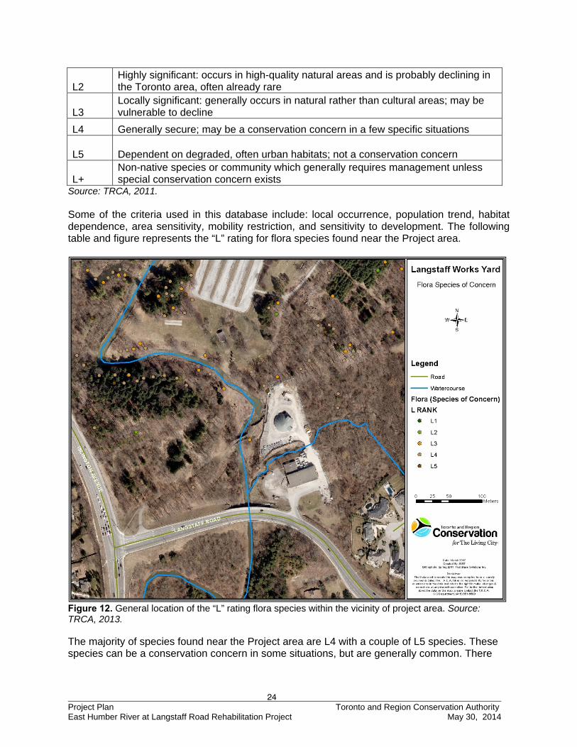
Source: TRCA, 2011. Some of the criteria used in this database include: local occurrence, population trend, habitat dependence, area sensitivity, mobility restriction, and sensitivity to development. The following table and figure represents the “L” rating for flora species found near the Project area.
Figure 12. General location of the “L” rating flora species within the vicinity of project area. Source: TRCA, 2013. The majority of species found near the Project area are L4 with a couple of L5 species. These species can be a conservation concern in some situations, but are generally common. There
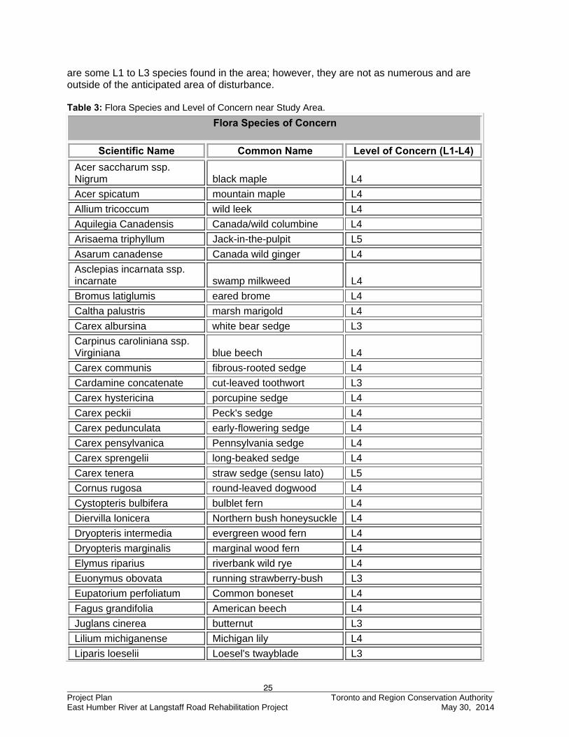
25 Project Plan Toronto and Region Conservation Authority East Humber River at Langstaff Road Rehabilitation Project May 30, 2014
are some L1 to L3 species found in the area; however, they are not as numerous and are outside of the anticipated area of disturbance. Table 3: Flora Species and Level of Concern near Study Area.
Flora Species of Concern
Scientific Name Common Name Level of Concern (L1-L4)
Acer saccharum ssp. Nigrum black maple L4
Acer spicatum mountain maple L4
Allium tricoccum wild leek L4
Aquilegia Canadensis Canada/wild columbine L4
Arisaema triphyllum Jack-in-the-pulpit L5
Asarum canadense Canada wild ginger L4
Asclepias incarnata ssp. incarnate swamp milkweed L4
Bromus latiglumis eared brome L4
Caltha palustris marsh marigold L4
Carex albursina white bear sedge L3
Carpinus caroliniana ssp. Virginiana blue beech L4
Carex communis fibrous-rooted sedge L4
Cardamine concatenate cut-leaved toothwort L3
Carex hystericina porcupine sedge L4
Carex peckii Peck's sedge L4
Carex pedunculata early-flowering sedge L4
Carex pensylvanica Pennsylvania sedge L4
Carex sprengelii long-beaked sedge L4
Carex tenera straw sedge (sensu lato) L5
Cornus rugosa round-leaved dogwood L4
Cystopteris bulbifera bulblet fern L4
Diervilla lonicera Northern bush honeysuckle L4
Dryopteris intermedia evergreen wood fern L4
Dryopteris marginalis marginal wood fern L4
Elymus riparius riverbank wild rye L4
Euonymus obovata running strawberry-bush L3
Eupatorium perfoliatum Common boneset L4
Fagus grandifolia American beech L4
Juglans cinerea butternut L3
Lilium michiganense Michigan lily L4
Liparis loeselii Loesel's twayblade L3
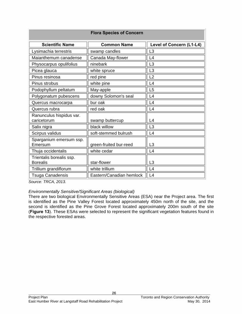
26 Project Plan Toronto and Region Conservation Authority East Humber River at Langstaff Road Rehabilitation Project May 30, 2014
Flora Species of Concern
Scientific Name Common Name Level of Concern (L1-L4)
Lysimachia terrestris swamp candles L3
Maianthemum canadense Canada May-flower L4
Physocarpus opulifolius ninebark L3
Picea glauca white spruce L3
Pinus resinosa red pine L2
Pinus strobus white pine L4
Podophyllum peltatum May-apple L5
Polygonatum pubescens downy Solomon's seal L4
Quercus macrocarpa bur oak L4
Quercus rubra red oak L4
Ranunculus hispidus var. caricetorum swamp buttercup L4
Salix nigra black willow L3
Scirpus validus soft-stemmed bulrush L4
Sparganium emersum ssp. Emersum green-fruited bur-reed L3
Thuja occidentalis white cedar L4
Trientalis borealis ssp. Borealis star-flower L3
Trillium grandiflorum white trillium L4
Tsuga Canadensis Eastern/Canadian hemlock L4
Source: TRCA, 2013. Environmentally Sensitive/Significant Areas (biological) There are two biological Environmentally Sensitive Areas (ESA) near the Project area. The first is identified as the Pine Valley Forest located approximately 450m north of the site, and the second is identified as the Pine Grove Forest located approximately 200m south of the site (Figure 13). These ESAs were selected to represent the significant vegetation features found in the respective forested areas.
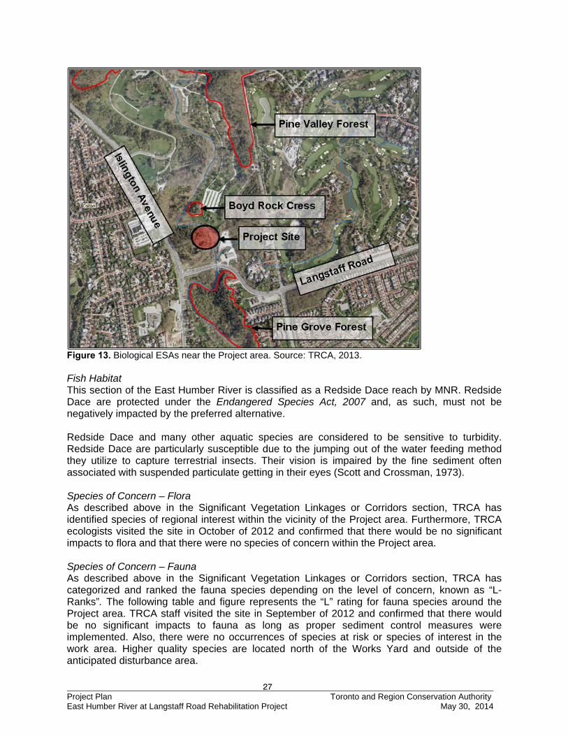
27 Project Plan Toronto and Region Conservation Authority East Humber River at Langstaff Road Rehabilitation Project May 30, 2014
Figure 13. Biological ESAs near the Project area. Source: TRCA, 2013. Fish Habitat This section of the East Humber River is classified as a Redside Dace reach by MNR. Redside Dace are protected under the Endangered Species Act, 2007 and, as such, must not be negatively impacted by the preferred alternative. Redside Dace and many other aquatic species are considered to be sensitive to turbidity. Redside Dace are particularly susceptible due to the jumping out of the water feeding method they utilize to capture terrestrial insects. Their vision is impaired by the fine sediment often associated with suspended particulate getting in their eyes (Scott and Crossman, 1973). Species of Concern – Flora As described above in the Significant Vegetation Linkages or Corridors section, TRCA has identified species of regional interest within the vicinity of the Project area. Furthermore, TRCA ecologists visited the site in October of 2012 and confirmed that there would be no significant impacts to flora and that there were no species of concern within the Project area. Species of Concern – Fauna As described above in the Significant Vegetation Linkages or Corridors section, TRCA has categorized and ranked the fauna species depending on the level of concern, known as “L-Ranks”. The following table and figure represents the “L” rating for fauna species around the Project area. TRCA staff visited the site in September of 2012 and confirmed that there would be no significant impacts to fauna as long as proper sediment control measures were implemented. Also, there were no occurrences of species at risk or species of interest in the work area. Higher quality species are located north of the Works Yard and outside of the anticipated disturbance area.
28 Project Plan Toronto and Region Conservation Authority East Humber River at Langstaff Road Rehabilitation Project May 30, 2014
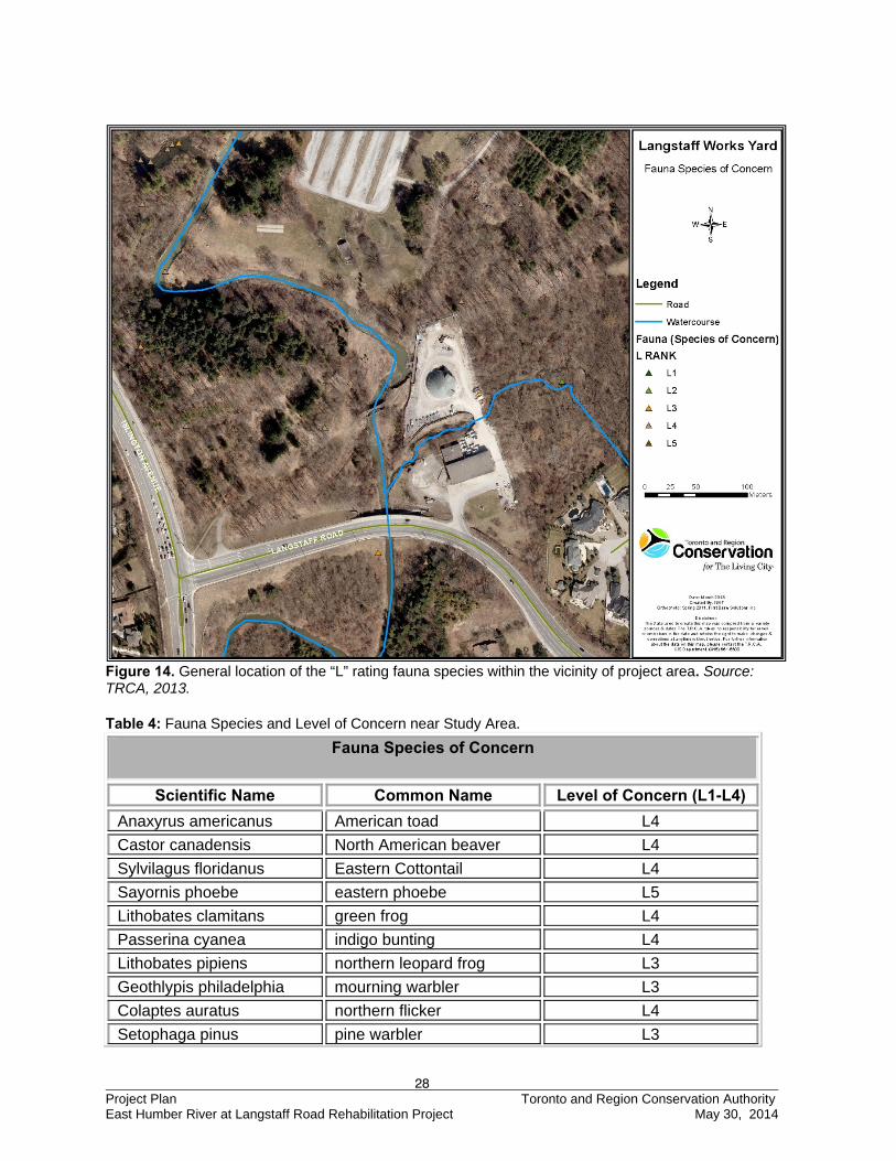
Figure 14. General location of the “L” rating fauna species within the vicinity of project area. Source: TRCA, 2013. Table 4: Fauna Species and Level of Concern near Study Area.
Fauna Species of Concern
Scientific Name Common Name Level of Concern (L1-L4)
Anaxyrus americanus American toad L4
Castor canadensis North American beaver L4
Sylvilagus floridanus Eastern Cottontail L4
Sayornis phoebe eastern phoebe L5
Lithobates clamitans green frog L4
Passerina cyanea indigo bunting L4
Lithobates pipiens northern leopard frog L3
Geothlypis philadelphia mourning warbler L3
Colaptes auratus northern flicker L4
Setophaga pinus pine warbler L3
29 Project Plan Toronto and Region Conservation Authority East Humber River at Langstaff Road Rehabilitation Project May 30, 2014
Fauna Species of Concern
Scientific Name Common Name Level of Concern (L1-L4)
Pheucticus ludovicianus rose-breasted grosbeak L4
Vireo olivaceus red-eyed vireo L4
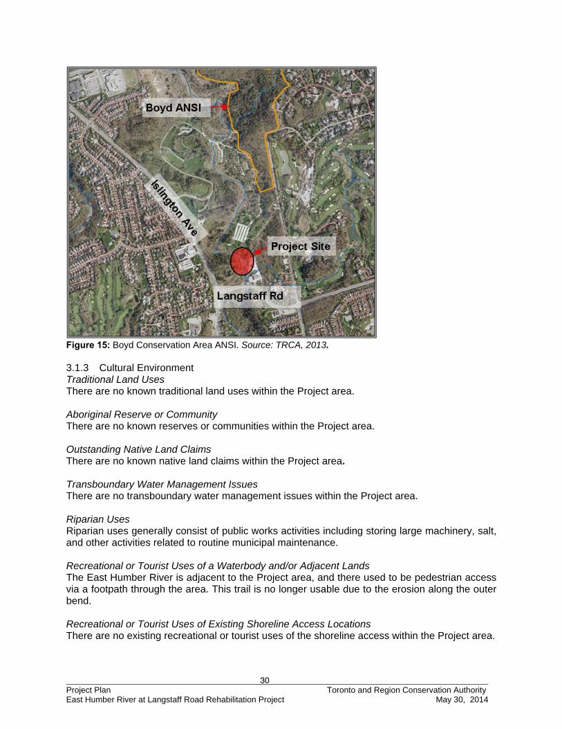
Hyla versicolor grey treefrog L2 Source: TRCA, 2013. Exotic/Alien and Invasive Species There are several terrestrial exotic/alien and invasive species found within the Project area, which can cause problems with the local environment. The most abundant invasive species are Common reed (Phragmites australis) and Manitoba maple (Acer negundo). Both of these species reproduce prolifically and tend to out-compete many desirable plant species. Wildlife/Bird Migration Patterns Boyd Conservation Area surrounding the Project area is an important migratory zone for birds and an important corridor for other terrestrial species. However, the Project area is not a significant migratory zone as it is adjacent to the Works Yard which generates a lot of noise.. Wildlife Population At the time of survey by TRCA in 2012, it was noted that no wildlife other than the aforementioned species of concern were identified. Some of the common animals sighted within the parklands include the eastern gray squirrel, raccoon, deer, and fox. Wetlands TRCA fauna biologists observed a vernal pool within the forested area northeast of the Works Yard. While significant, it is outside of the Project area and won’t be impacted by remedial works. Microclimate There are no unique microclimate areas within the Project area. Unique Habitats There are no unique habitats present within the Project area. Areas of Natural Scientific Interest - Life Science (ANSI-LS) Within the Project area, there is a life science ANSI referred to as the Boyd Conservation Area and adjacent lands. This ANSI includes the northeast corner of Boyd Conservation Area and the uplands adjacent to its east side (Figure 15). The site is characterized by dense, semi-mature to mature hemlock forests that dominate the steepened slope areas. The uplands are home to beech-sugar, maple-hemlock, hemlock-sugar, maple-white birch, red oak-black, and maple-sugar maple forests. The 57 ha ANSI provides the best representation of mature bottomland terrace and valley slope and tableland forests on the Peel Plain. It is also noted for its oxbow wetlands (MNR 2013). As the Project area is located to the south of the ANSI, construction activities will not likely impact its function in anyway.
30 Project Plan Toronto and Region Conservation Authority East Humber River at Langstaff Road Rehabilitation Project May 30, 2014
Figure 15: Boyd Conservation Area ANSI. Source: TRCA, 2013. 3.1.3 Cultural Environment Traditional Land Uses There are no known traditional land uses within the Project area. Aboriginal Reserve or Community There are no known reserves or communities within the Project area. Outstanding Native Land Claims There are no known native land claims within the Project area. Transboundary Water Management Issues There are no transboundary water management issues within the Project area. Riparian Uses Riparian uses generally consist of public works activities including storing large machinery, salt, and other activities related to routine municipal maintenance. Recreational or Tourist Uses of a Waterbody and/or Adjacent Lands The East Humber River is adjacent to the Project area, and there used to be pedestrian access via a footpath through the area. This trail is no longer usable due to the erosion along the outer bend. Recreational or Tourist Uses of Existing Shoreline Access Locations There are no existing recreational or tourist uses of the shoreline access within the Project area.
31 Project Plan Toronto and Region Conservation Authority East Humber River at Langstaff Road Rehabilitation Project May 30, 2014
Aesthetic or Scenic Landscapes or Views The Project area is located within the Boyd Conservation Area which is perceived as having a high aesthetic value due to the open green space and expansive forest. The project area is adjacent to the Works Yard and is likely viewed as having less aesthetic value than the surrounding green space. However, the heritage listed bowstring bridge downstream of the eroding meander is a desirable feature that enhances the scenic landscape. Archaeological Resources, Built Heritage Resources and Cultural Heritage Landscapes The Ontario Archaeological Sites Database (OASD) maintained by the Ministry of Tourism and Culture (MTC) indicates that no archaeological sites have been previously registered within the Project area. However, there were 3 sites located within one kilometre of the Project area. The following three archeological sites were identified:
1) Boyd Village, Middle Iroquoian, Late Woodland, Sweetman 1958, Konrad 1971 (AkGv-3) 2) Latree Village, Woodland, Burgar 1995 (AkGv-139) 3) Findspot, Pre-contact, Jolly 2010 (AkGv-305)
Historical Canals There are no historic canals within the Project area. Federal Property The Project is located on TRCA and City of Vaughan lands, with the exception of the bed of the Humber River which is owned by the Crown and therefore subject to review under the Public Lands Act. Heritage River System The Humber River flows through the Project area. The Humber River was officially designated as a Heritage River is 1999. Therefore, it is critical to retain the natural characteristics and features of the river. Some of the most notable features are the Oak Ridges Moraine, Niagara Escarpment, Humber Marshes, and High Park (CHRS 2014). 3.1.4 Socioeconomic Environment Surrounding Neighbourhood or Community The Project area is located within the City of Vaughan, which has a total land area of 273.52 km2 and is located within York Region (Vaughan, 2011). The Vaughan community is home to approximately 288,301 people and consists of about 88,282 households. The community is composed of 20.3 % children (0 – 14), 13.7 % youth (15 – 24 yrs), 54.8 % working age individuals (25 – 64 yrs), and 11.2 % seniors (65 years or greater) (StatCan, 2011). Surrounding Land Uses and Growth Pressure The Project area spans a conservation area and Works Yard. There is little growth pressure through the area as the land is in public ownership. Existing Infrastructure, Support Services, Facilities There is infrastructure servicing the Works Yard. Also, there is an abandoned watermain that runs through the eroded bank.
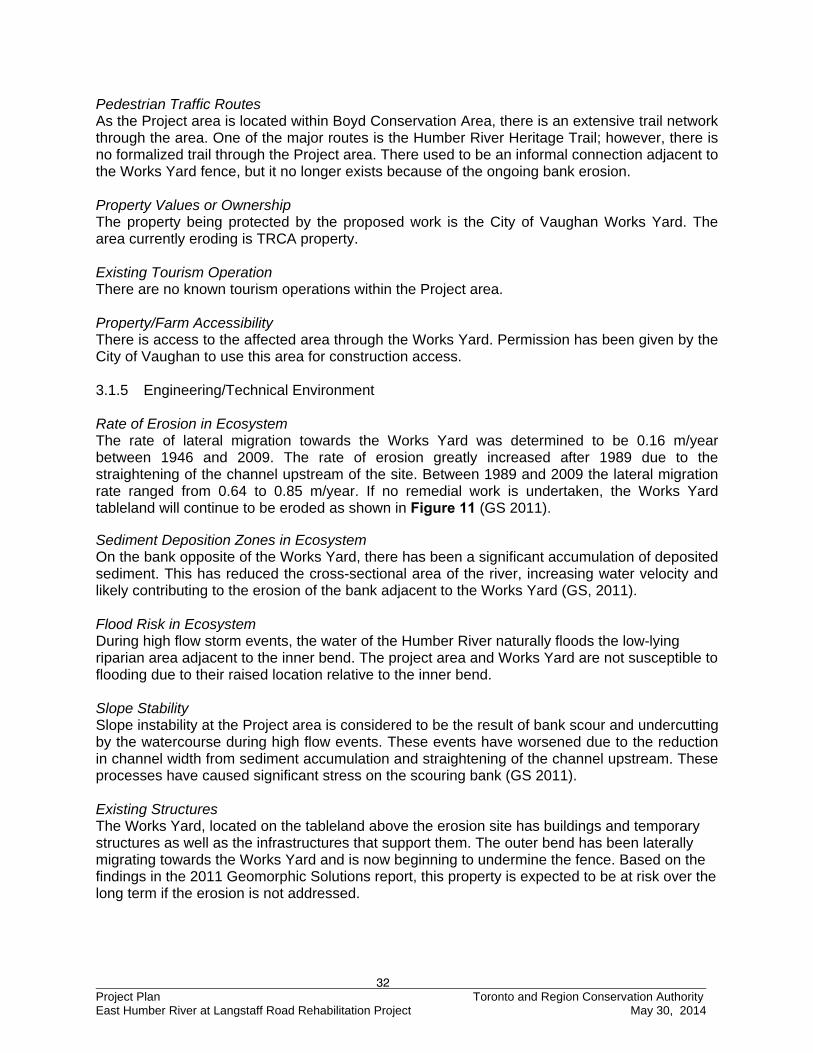
32 Project Plan Toronto and Region Conservation Authority East Humber River at Langstaff Road Rehabilitation Project May 30, 2014
Pedestrian Traffic Routes As the Project area is located within Boyd Conservation Area, there is an extensive trail network through the area. One of the major routes is the Humber River Heritage Trail; however, there is no formalized trail through the Project area. There used to be an informal connection adjacent to the Works Yard fence, but it no longer exists because of the ongoing bank erosion. Property Values or Ownership The property being protected by the proposed work is the City of Vaughan Works Yard. The area currently eroding is TRCA property. Existing Tourism Operation There are no known tourism operations within the Project area. Property/Farm Accessibility There is access to the affected area through the Works Yard. Permission has been given by the City of Vaughan to use this area for construction access. 3.1.5 Engineering/Technical Environment Rate of Erosion in Ecosystem The rate of lateral migration towards the Works Yard was determined to be 0.16 m/year between 1946 and 2009. The rate of erosion greatly increased after 1989 due to the straightening of the channel upstream of the site. Between 1989 and 2009 the lateral migration rate ranged from 0.64 to 0.85 m/year. If no remedial work is undertaken, the Works Yard tableland will continue to be eroded as shown in Figure 11 (GS 2011). Sediment Deposition Zones in Ecosystem On the bank opposite of the Works Yard, there has been a significant accumulation of deposited sediment. This has reduced the cross-sectional area of the river, increasing water velocity and likely contributing to the erosion of the bank adjacent to the Works Yard (GS, 2011). Flood Risk in Ecosystem During high flow storm events, the water of the Humber River naturally floods the low-lying riparian area adjacent to the inner bend. The project area and Works Yard are not susceptible to flooding due to their raised location relative to the inner bend. Slope Stability Slope instability at the Project area is considered to be the result of bank scour and undercutting by the watercourse during high flow events. These events have worsened due to the reduction in channel width from sediment accumulation and straightening of the channel upstream. These processes have caused significant stress on the scouring bank (GS 2011). Existing Structures The Works Yard, located on the tableland above the erosion site has buildings and temporary structures as well as the infrastructures that support them. The outer bend has been laterally migrating towards the Works Yard and is now beginning to undermine the fence. Based on the findings in the 2011 Geomorphic Solutions report, this property is expected to be at risk over the long term if the erosion is not addressed.
33 Project Plan Toronto and Region Conservation Authority East Humber River at Langstaff Road Rehabilitation Project May 30, 2014
Hazardous Lands/Sites There are no known hazardous lands or sites within the Project area; however, the bank erosion classifies the Project area as potentially hazardous land in terms of risk to property and public safety. 4.0 EVALUATION OF REMEDIAL ALTERNATIVE OPTIONS The information obtained in completing the baseline inventory is used in the evaluation of alternative options, giving specific consideration to the advantages and disadvantages of each method.
4.1 Description of Preliminary Concepts
In July 2012, TRCA retained the services of GHD Inc. (the new parent company of Geomorphic Solutions) for the purpose of developing site-appropriate remedial alternative options to address the ongoing erosion through the Class EA process. GHD was selected based on previous experience and a strong understanding of the processes occurring at this site. GHD designed four conceptual alternatives to remediate the active erosion scar. These options were presented to the Technical Steering Committee (TSC) at Meeting #1, held in the afternoon of January 9th, 2013 at TRCA’s Boyd Office located at 9755 Canada Company Avenue. A description and evaluation of the preliminary alternatives follows. The evaluation includes an examination of the types and extents of impacts, both positive and negative, of each alternative. 4.1.1 Preliminary Option 1 - “Do Nothing” Alternative
The “Do Nothing” option is a mandatory alternative that must be considered in the Class EA process, as it is used to justify the need to undertake a remedial flood or erosion control project. Should the “Do Nothing” option, or other Conservation Authority programs such as land acquisition be deemed to be a more acceptable solution, then there is no further consideration for remedial action and the Class EA process terminates. The “Do Nothing” approach will allow bank erosion to continue with the possibility that erosion may accelerate. The projected positions of the channel bend in 2015, 2020, 2030, and 2045 are provided in Figure 16, assuming the lateral migration continues at the average rate between 1999 and 2011. The projected channel bend shown as 2015 and 2016 on Figure 16 is limited as subsurface conditions were not known for the parking lot and Works Yard area. This information was not available at the time of the investigation; therefore, the meander bend projection does not contain a migration adjustment to account for the soil conditions in this area. Active erosion is expected to continue adversely impacting aquatic habitat by the continued input of fines and sedimentation of the East Humber River. This increase in turbidity negatively affects the ability of many fish species to complete biological needs such as spawning, feeding, and limits the use of refugia in pools that have been filled with fine materials. Terrestrial habitat will be lost at the upstream and downstream bends due to continued bank erosion. The pedestrian trail would either have to be relocated from the bank or removed completely. Given the current migration rate, the Works Yard could be compromised in the short-term with a continued loss of land, and the river may shift out of alignment with Langstaff Road placing the overpass footings at risk.
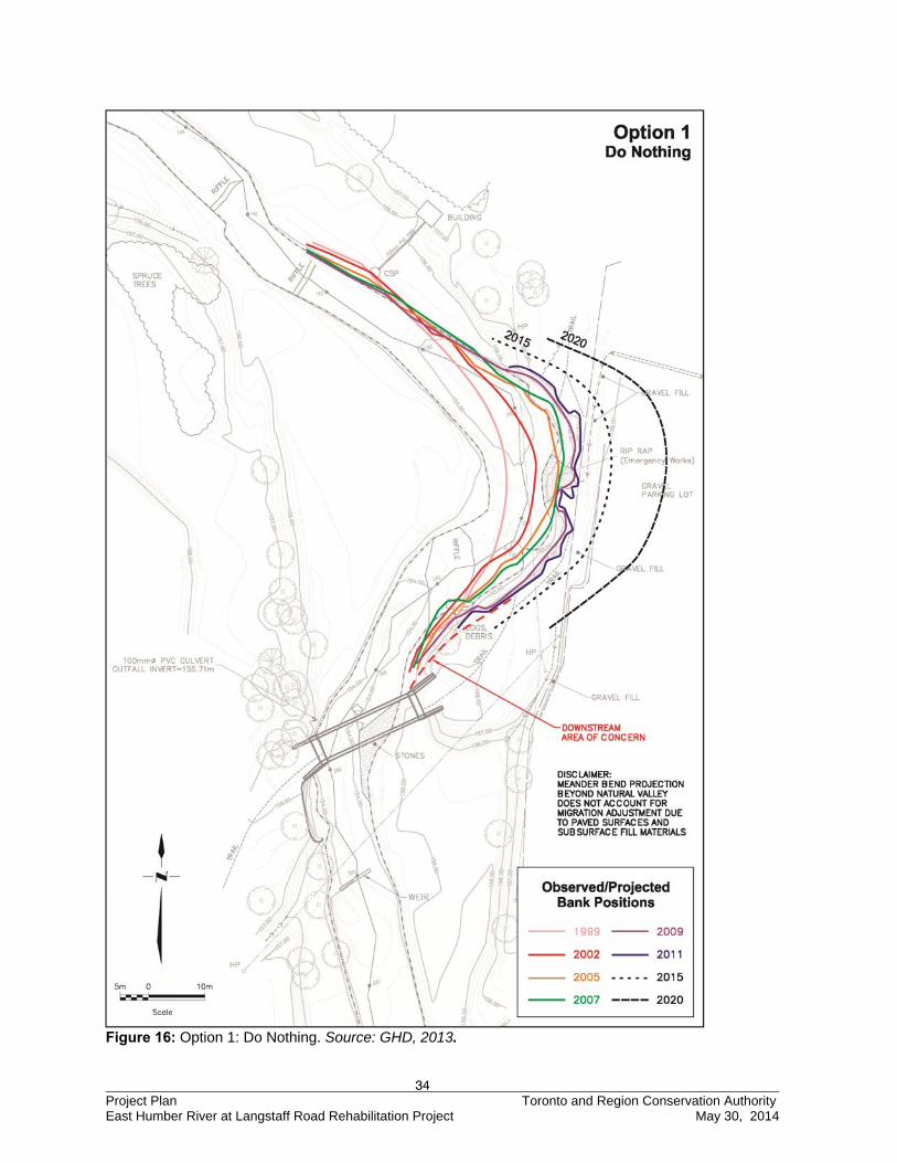
34 Project Plan Toronto and Region Conservation Authority East Humber River at Langstaff Road Rehabilitation Project May 30, 2014
Figure 16: Option 1: Do Nothing. Source: GHD, 2013.
35 Project Plan Toronto and Region Conservation Authority East Humber River at Langstaff Road Rehabilitation Project May 30, 2014
4.1.2 Preliminary Option 2 – Local Armouring without Channel Infilling
The second alternative involves local bank protection within the existing footprint of the erosion scar, using either a vegetated rock buttress or a live crib wall treatment. Applying bank treatments is the simplest and cheapest approach to address the erosion hazard as shown in Figure 17. This option will have a minor impact on the existing channel morphology. While the bank treatment provides local stabilization, it does not address the issue of flow direction and downstream erosion impacts. At present, the flow is directed towards the outer bank at the downstream meander bend. Without proper flow training or protection, the erosive forces may be exacerbated on the downstream bank. Furthermore, aquatic habitat will be enhanced through the mitigation of erosion that will reduce sediment input into the river. The vegetation in the treatment will also enhance the riparian area. The impact to the channel is expected to be short-term and predominantly during the placement of the toe stone. However, a relatively large grading and construction footprint required for the bank treatment will temporarily impact the existing terrestrial habitat, but it can be re-established through an aggressive planting plan within and beyond the bioengineered bank treatment. Under this option, the grading extent and trail network would result in a significant loss of land at the Works Yard.
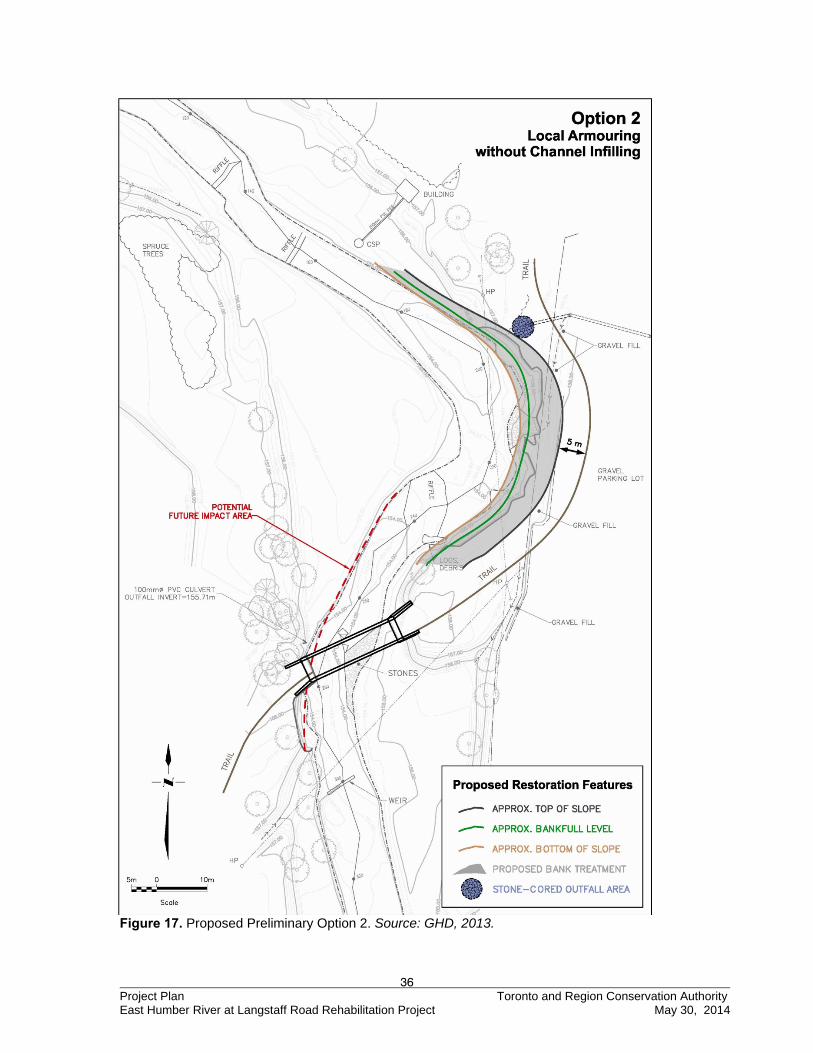
36 Project Plan Toronto and Region Conservation Authority East Humber River at Langstaff Road Rehabilitation Project May 30, 2014
Figure 17. Proposed Preliminary Option 2. Source: GHD, 2013.
37 Project Plan Toronto and Region Conservation Authority East Humber River at Langstaff Road Rehabilitation Project May 30, 2014
4.1.3 Preliminary Option 3 – Local Armouring and Downstream Protection without Channel Infilling
The third alternative involves local bank protection within the existing footprint of the erosion scar and downstream bank protection at the existing bridge location (Figure 18). Applying the upstream bank treatment would be a similar approach to address the erosion hazard under Option 2. However, downstream bank treatments can be installed to provide stabilization and reduce the impact of erosive forces along the outside meander and the existing bridge abutment. This option will have a similar impact to the geomorphic conditions and aquatic habitat compared to Option 2. However, aquatic habitat will be further enhanced through the mitigation of erosion and elimination of the input of fines from the downstream meander bend. The grading extent and trail network would result in a similar reduction in the loss of land at the Vaughan Public Works as Option 2. However, additional short-term construction impacts are anticipated for the downstream bank treatment, particularly on aquatic and terrestrial habitat. The terrestrial habitat can be re-established through an aggressive planting plan.
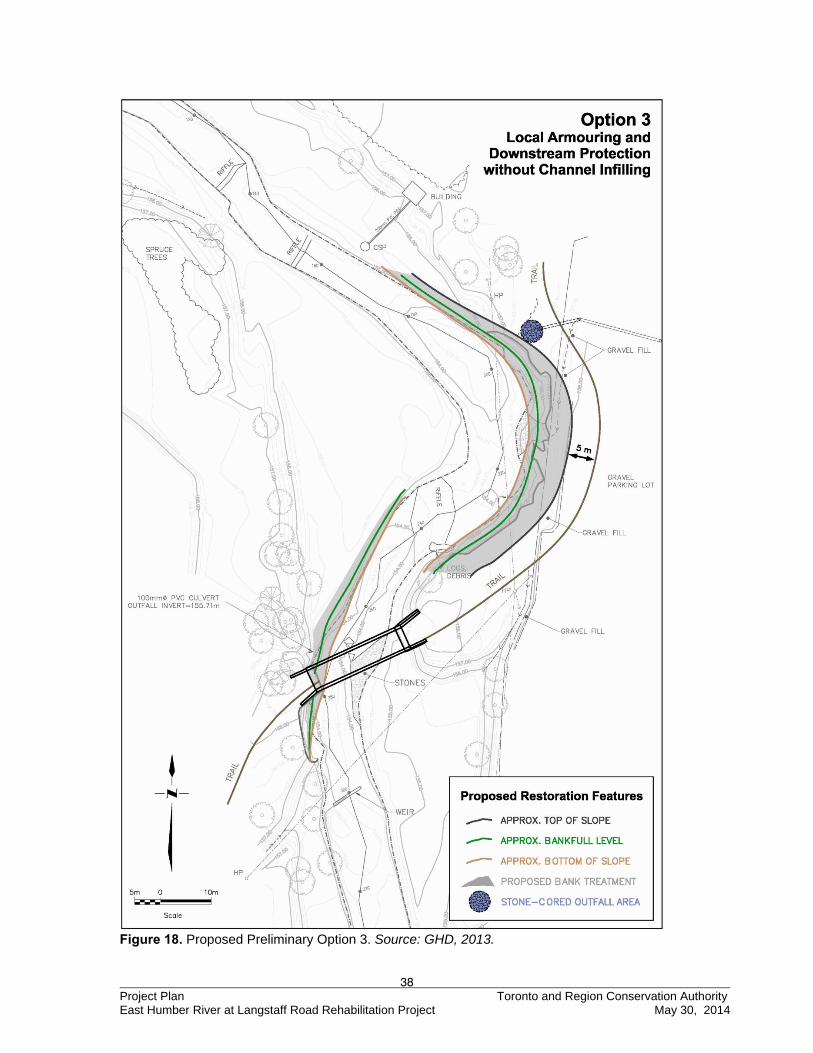
38 Project Plan Toronto and Region Conservation Authority East Humber River at Langstaff Road Rehabilitation Project May 30, 2014
Figure 18. Proposed Preliminary Option 3. Source: GHD, 2013.
39 Project Plan Toronto and Region Conservation Authority East Humber River at Langstaff Road Rehabilitation Project May 30, 2014
4.1.4 Preliminary Option 4 – Minor Realignment Works
The fourth alternative involves local bank protection with minor channel realignment (i.e. infilling) in the vicinity of the erosion scar and downstream bank protection at the existing bridge location (Figure 19). Applying bank treatments is similar to the approach to address the erosion hazard under Options 2 and 3. However, the extent of the downstream bank treatment is reduced due to the new flow direction of the upstream channel. Local re-grading of point bars reduces the erosive forces along the outside bends and increases the cross-sectional area of the channel. This option will have a moderate impact on the existing geomorphic and aquatic habitat morphology in the vicinity of the upstream meander bend. However, it is anticipated that the natural readjustment of the bed morphology will occur over time. Aquatic habitat will also be enhanced through the mitigation of erosion, elimination of the input of fines, and riparian vegetation. A relatively larger grading and construction footprint is required for this option and will have a greater negative impact on existing aquatic and terrestrial habitat relative to Option 3. However, due to the proposed flow alignment from the upstream bend, the extent of the downstream bank treatment would be reduced compared to Option 3. In addition to the local regrading of the point bars, the new alignment will reduce the hydraulic sizing requirements of any proposed bank treatment. The grading extent and trail network would result in a smaller loss of land at the Vaughan Public Works than Options 2 and 3.
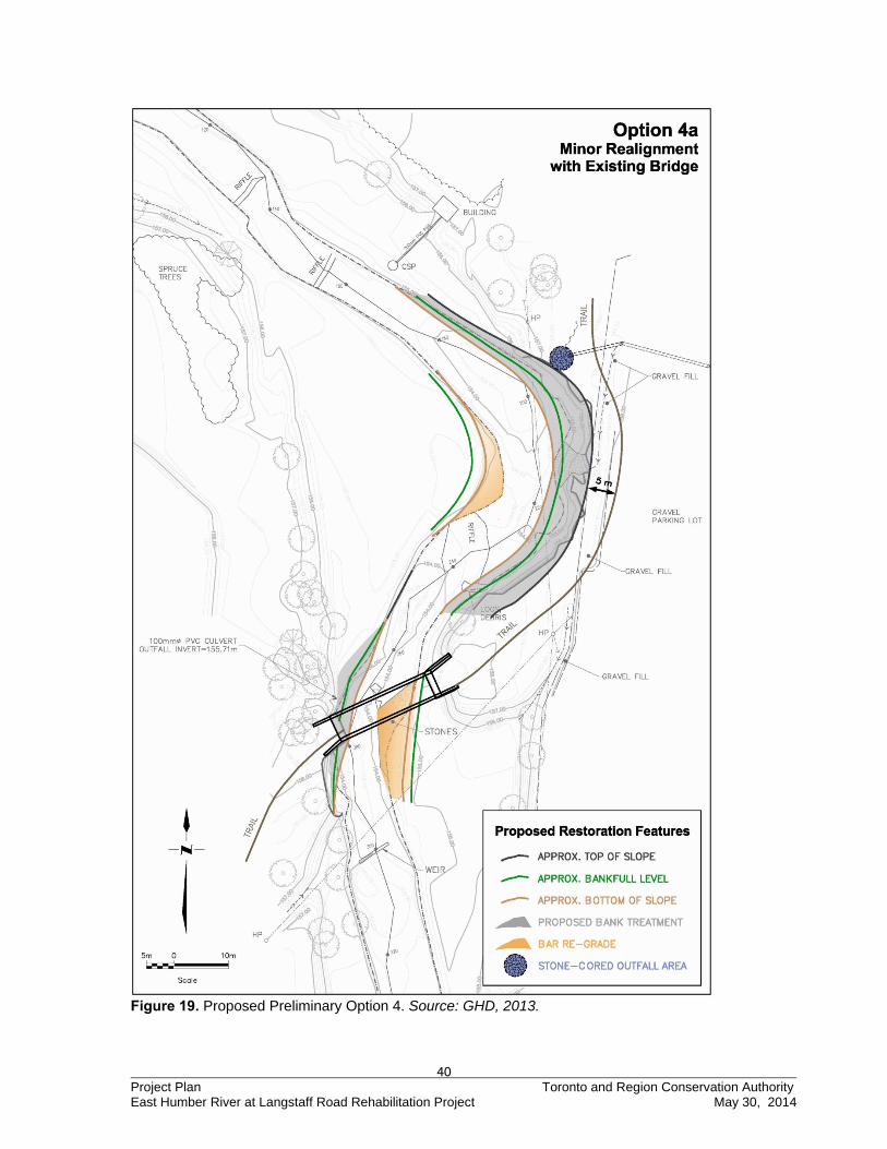
40 Project Plan Toronto and Region Conservation Authority East Humber River at Langstaff Road Rehabilitation Project May 30, 2014
Figure 19. Proposed Preliminary Option 4. Source: GHD, 2013.
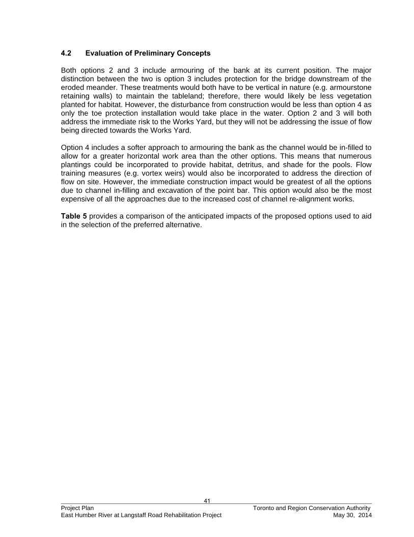
41 Project Plan Toronto and Region Conservation Authority East Humber River at Langstaff Road Rehabilitation Project May 30, 2014
4.2 Evaluation of Preliminary Concepts Both options 2 and 3 include armouring of the bank at its current position. The major distinction between the two is option 3 includes protection for the bridge downstream of the eroded meander. These treatments would both have to be vertical in nature (e.g. armourstone retaining walls) to maintain the tableland; therefore, there would likely be less vegetation planted for habitat. However, the disturbance from construction would be less than option 4 as only the toe protection installation would take place in the water. Option 2 and 3 will both address the immediate risk to the Works Yard, but they will not be addressing the issue of flow being directed towards the Works Yard. Option 4 includes a softer approach to armouring the bank as the channel would be in-filled to allow for a greater horizontal work area than the other options. This means that numerous plantings could be incorporated to provide habitat, detritus, and shade for the pools. Flow training measures (e.g. vortex weirs) would also be incorporated to address the direction of flow on site. However, the immediate construction impact would be greatest of all the options due to channel in-filling and excavation of the point bar. This option would also be the most expensive of all the approaches due to the increased cost of channel re-alignment works. Table 5 provides a comparison of the anticipated impacts of the proposed options used to aid in the selection of the preferred alternative.
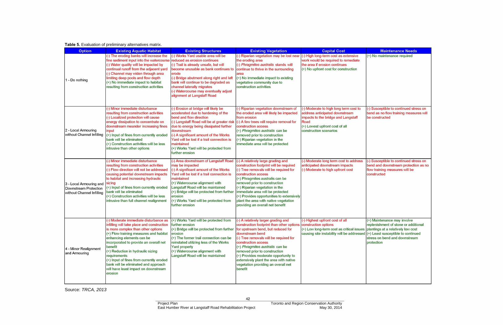
42 Project Plan Toronto and Region Conservation Authority East Humber River at Langstaff Road Rehabilitation Project May 30, 2014
Table 5. Evaluation of preliminary alternatives matrix.
Source: TRCA, 2013
43 Project Plan Toronto and Region Conservation Authority East Humber River at Langstaff Road Rehabilitation Project May 30, 2014
4.3 Selection of the Preferred Alternative The preferred alternative was selected following discussion between TRCA and GHD staff based on the review of feedback forms and comments provided by the TSC members after the first meeting. Option 3 was selected as the preferred alternative to address erosion concerns at the Project area. This option provides immediate long-term stability to the Works Yard by protecting the bank and will have a low impact to aquatic habitat as in-water work will be minimal. Primary considerations for these selections included:
Providing adequate long-term stability of the river bank and protection of public safety; Compatibility with, and minimizing impacts on, the surrounding physical and biological
environment; Providing terrestrial and aquatic enhancements to the greatest extent possible; Cost effectiveness; and Public opinion
Design drawings of the preferred alternative are found in Appendix D. The evaluation forms completed by TSC members regarding the alternative options which lead to development of the preferred alternatives are discussed further in Section 6.0 of this report; detailed minutes of the TSC meetings can be found in Appendix E. 4.4 Refinement of the Preferred Alternative As of July 8, 2013, there have been significant changes on site following the selection of Option 3 as the preferred alternative on May 21, 2013. The erosion has shifted further downstream displacing a tree and eroding a 4 meter high bank composed predominantly of fill and is now placing the bowstring bridge at risk of being outflanked. Maintaining a stable channel planform underneath the bowstring bridge and Langstaff Road is critical for site security, so addressing this new bank erosion may require some modifications at the detailed design level. The overall approach will remain aligned with the principles of the preferred alternative. 5.0 ENVIRONMENTAL SCREENING 5.1 Detailed Environmental Analysis of the Preferred Alternatives To complete the detailed environmental analysis of the preferred alternatives, the information collected for the baseline inventory is examined in greater detail to confirm potential impacts, refine methods of mitigation, and to identify any unforeseen impacts. The evaluation of impacts includes both temporary impacts during construction of the undertaking, and permanent impacts due to function and maintenance of the works after construction. Table 6 screens the potential negative and positive effects of the proposed undertaking on the environment during construction and maintenance phases. It includes the consideration of the magnitude, geographic extent, duration, frequency, permanence or reversibility and ecological context of the effects, as well as proposed mitigation measures and any residual effects.
44 Project Plan Toronto and Region Conservation Authority East Humber River at Langstaff Road Rehabilitation Project May 30, 2014
Environmental components that have been identified as potentially having an effect on the environment, both positive and negative, are discussed herein. Those that have been determined as not applicable (n/a) as identified in Table 6, have been omitted from further discussion.
45 Project Plan Toronto and Region Conservation Authority East Humber River at Langstaff Road Rehabilitation Project May 30, 2014
Table 6. Detailed Environmental Analysis of the Preferred Alternative. Rating of Potential Effects Screening Criteria -H -M -L NIL +L +M +H NA Comments Physical
Unique Landforms ●
Existing Mineral/Aggregate Resources Extraction Industries ●
Earth Science - Areas of Natural and Scientific Interest ● Construction is downstream of the ANSI and is not expected to impact the area in any way.
Specialty Crop Areas ●
Agricultural Lands or Production ●
Niagara Escarpment ●
Oak Ridges Moraine ●
Environmentally Sensitive/Significant Areas (physical) ● Construction will not occur within or near the ESA areas.
Air Quality ● Mitigative measures will be taken to minimize impacts of equipment use during construction.
Agricultural Tile or Surface Drains ●
Noise Levels and Vibration ● Mitigative measures will be taken to minimize impacts of equipment use during construction.
High/Storm Water Flow Regime ●
Low/Base Water Flow Regime ●
Existing Surface Drainage and Groundwater Seepage ● Proposed remedial work will improve drainage system along the valley wall.
Groundwater Recharge/Discharge Zones ●
Littoral Drift ●
Other Coastal Processes (Wave Climate) ●
Water Quality ● Sediment release will be prevented by implementing sediment control BMPs during implementation.
Soil/Fill Quality ● Only clean soil or aggregate will be used in construction.
Contaminated Soils/Sediment/Seeps (Sediment Quality) ● Soils destined for off-site storage or disposal will be tested accordingly.
Existing Transportation Routes ● Existing residential road and Works Yard will be used to gain access the site and implement the remedial works.
Constructed Crossings (e.g. bridges, culverts) ● Proposed works are intended to protect the existing bridge abutments.
Geomorphology ● Negligible changes to river flow characteristics.
Other ● Biological
Wildlife Habitat ● Proposed remedial work will improve terrestrial habitat along the top of bank
Habitat Linkages or Corridors ● Project will result in a minor improvement to habitat linkages and corridors.
Significant Vegetation Communities ● All highly significant species are located outside the Project area
Environmentally Sensitive/ Significant Areas (biological) ●
Construction will not occur within ESA areas. Water quality improvements will benefit the downstream Pine Grove Forest ecosystem.
Fish Habitat ●
Fish will benefit from improvement to water quality through reduction of fines and from improved local cover provided by brush layers in the buttress. Woody debris will also be embedded into the buttress adjacent to the deep pools to provide cover.
Species of Concern ●
No threat to flora; Fauna of concern is to be protected through sediment fencing. Mitigation works will improve habitat in long term.
Exotic/Alien and Invasive Species ● Restoration plan will include only native vegetation and invasive species on site will be removed prior to construction.
Wildlife/Bird Migration Patterns ● Temporary disruption only, taking place between bird migratory periods.
Wildlife Population ● Short-term disruption only.
46 Project Plan Toronto and Region Conservation Authority East Humber River at Langstaff Road Rehabilitation Project May 30, 2014
Rating of Potential Effects Screening Criteria -H -M -L NIL +L +M +H NA Comments
Wetlands ● Sediment control practices will protect the vernal pool located north east of the work area.
Microclimate ● Unique Habitats ● Life Science - Areas of Natural and Scientific Interest ● The proposed site is located downstream and south of the Boyd ANSI.
Other ● Cultural
Traditional Land Uses ●
Aboriginal Reserve or Community ●
Outstanding Native Land Claim ●
Transboundary Water Management Issues ●
Riparian Uses ●
Recreational/Tourist Uses of Water Body and/or Adjacent Land ●
Recreational/Tourist Uses of Existing Shoreline Access ●
Aesthetic or Scenic Landscapes or Views ● Perceived significant improvement in aesthetics through restoration of vegetation.
Culturally Significant Resources ● Proposed design will protect existing heritage listed bridge abutments from further erosion.
Historic Canals ●
Federal Property ● Humber riverbed is owned by the Crown.
Heritage River System ● Remedial works will protect and enhance the Humber River without changing major features.
Other ● Socioeconomic
Surrounding Neighbourhood or Community ● There is no public access to the site therefore community disturbance is not likely.
Surrounding Land Uses or Growth Pressure ●
Existing Infrastructure, Support Services, Facilities ● Protects existing infrastructure and services.
Pedestrian Traffic Routes ●
Property Values or Ownership ● Proposed works will reduce or eliminate further loss of property and protect property value for the Vaughan Public Works Yard.
Existing Tourism Operations ●
Property/Farm Accessibility ●
Other ● Engineering/Technical
Rate of Erosion in Ecosystem ● Proposed works will stop lateral erosion on site and should not significantly impact erosion downstream.
Sediment Deposition Zones in Ecosystem ●
Flood Risk in Ecosystem ●
Slope Stability ● Proposed works will effectively stabilize the slope.
Existing Structures ● Long term protection of existing structures is achieved.
Hazardous Lands/Hazardous Sites ●
Other Engineering Projects at this Location ● Note. Screening of potential effects as negative (-), neutral (NIL) or positive (+) and rating them as relatively high (H), medium (M), low (L) or not applicable (NA). From Conservation Ontario, Class Environmental Assessment for Remedial Flood and Erosion Control Projects, 2013, p23, Table 3.
47 Project Plan Toronto and Region Conservation Authority East Humber River at Langstaff Road Rehabilitation Project May 30, 2014
5.1.1 Physical Environment
Water Flow Regime (High / Base and Low / Base) Water flows within this area of the East Humber will be minimally impacted during construction activities. Temporarily narrowing of the channel will cause some disturbance and minor concentration of flow to the inner meander and adjacent flood plain. In the event of heavy rainfall or flood warnings, work near the water will stop and any damaged sediment control structures will be replaced. Water Quality Continuous monitoring equipment will collect turbidity data every 15 minutes at stations located both upstream and downstream of the site. Data will be monitored by project management staff who will ensure timely adjustments if data is less than optimal. Best management practices for sediment control are enforced on all TRCA construction sites, and engineered designs will ensure sufficient sediment barriers so that fish or fish habitat are not harmed during construction activities. Sediment fencing will quarantine the activities while they take place near the toe, and work near the toe will be limited to stone placement. All heavy equipment will access this area from the top of the bank along the yard works property. At no time will heavy equipment enter the watercourse. Soil/Fill Quality The fertility of native soils will be enhanced with added top soil fill in order to encourage healthy plant growth. No detrimental impacts on the quality of the soil/fill material are expected. Constructed Crossings The heritage bowstring bridge is a desirable, culturally significant structure. As such, TRCA intends to preserve it for future recreational use. Even if the bridge cannot be restored, the concrete abutments will be left in place as removing them would have more severe impacts to watercourse ecology and morphology than simply leaving them in place. Geomorphology It is recognized that hardening a section of bank may result in changes upstream and downstream of the site with respect to sediment yield and transport. The proposed erosion control works will cut back into the Works Yard to stabilize the bank and maintain the existing cross-sectional area of the channel. A bio-engineered buttress will be utilized which will absorb rather than deflect stream energy responsible for erosion. 5.1.2 Biological Environment
Wildlife Habitat Temporary disruption of wildlife habitat will occur during construction due to the minor clearing required for the access route and construction stockpile and staging areas. Since the Project is located adjacent to the Works Yard, existing habitat resources on site are limited. The proposed design will also provide improvements to riparian habitat through intensive plantings along the buttress and by embedding woody debris adjacent to deep pools to provide cover. Habitat Linkages or Corridors The proposed project will have minor positive impacts as the corridor along the east bank will be re-established.
48 Project Plan Toronto and Region Conservation Authority East Humber River at Langstaff Road Rehabilitation Project May 30, 2014
Significant Vegetation Communities Species of interest identified at this site include Level 3 (L3) to Level 5 (L5) ranked species, which are identified as species able to withstand minor to moderate disturbance, furthermore there were only five such species found within the general area of disturbance. There were no species identified within the Project area that were not able to withstand minor disturbances. All practical measures will be taken to ensure that site disruption is minimized; therefore, no significant adverse impacts are expected. Fish Habitat This section of the East Humber River is an identified Redside Dace reach. As such, construction is scheduled to take place during the construction timing window of July 1st, 2014 and will be completed by September 15th, 2014. Appropriate erosion and sediment control measures will be installed prior to construction to minimize sediment input into the river. As this option does not include any channel in-filling, the in-water disturbance should be minimal. Completion of the work will benefit Redside Dace through reducing the input of sediment into the river by stabilizing the erosion. Redside Dace habitat improving elements have been incorporated into the design and include woody debris adjacent to pools and live staking within the buttress. Exotic/Alien and Invasive Species The impacts to the existing vegetation will be minimized, and only native materials will be used in the restoration of the site. No new exotic or invasive species will be introduced to the Project area as the result of the site restoration plan. During construction, any invasive species (such as Dog-strangling Vine, Phragmites and Manitoba Maple) located within the limits of construction activities will be removed and replaced with native species. Wildlife/Bird Migration Patterns Construction activities will have to take place between July 1st and September 15th, and this time should avoid the primary migration period for most of the bird species in the area. Construction activities are only expected to temporarily disturb resident wildlife. As the majority of construction will be taking place from the Works Yard property, this area will be used for construction access and stockpiling, further minimizing the impact to other species as this area is not considered suitable habitat. Any displacement of wildlife populations is anticipated to be short-term and is deemed acceptable when weighed against the overall increased vegetative cover and habitat improvements to the Project area. Wetlands TRCA ecology staff stated that this project will not impact the nearby vernal pool as long as proper erosion and sediment control measures are installed on site. 5.1.3 Cultural Environment
Riparian Uses The predominant riparian use is the Works Yard activities, and any construction would be coordinated with the yard. Therefore, any construction activities at the Project area would likely have a minimal impact on the riparian uses. Aesthetic or Scenic Landscapes or Views The increase of riparian vegetative cover along the west eroded bank will generally improve the aesthetic landscape by providing more natural scenery.
49 Project Plan Toronto and Region Conservation Authority East Humber River at Langstaff Road Rehabilitation Project May 30, 2014
Heritage River System The Humber River is considered a Heritage River therefore the preferred alternative design will retain or enhance representative characteristics as appropriate. 5.1.4 Socioeconomic Environment
Property Values or Ownership The proposed undertaking is not likely to have an adverse effect on the Works Yard property value. Conversely, the long-term protection of the affected bank is expected to protect the property value of this site. 5.1.5 Engineering/Technical Environment
Rate of Erosion in Ecosystem The final design is expected to effectively stabilize the bank against further lateral erosion and will maintain the existing alignment of the river to ensure the Langstaff Road crossing will be maintained. Slope Stability The unstable slope on-site will be stabilized as a result of the remedial works preventing the further input of fines and other fill material into the river. Existing Structures The proposed works will provide long-term protection for the existing Works Yard property and safeguard the downstream historic bridge from future erosion. 6.0 SUMMARY This section of the Project Plan provides a summary of comments received during the planning and design phases of the Project, a discussion of how these concerns have been addressed, and an outline of the monitoring program which will be implemented both during construction and once the Project is completed. 6.1 Role of the Community Liaison Committee The following information is provided from Conservation Ontario’s Class Environmental Assessment for Remedial Flood and Erosion Control Projects (January 2002).
“In an effort to facilitate more on-going public involvement at the project level, the Conservation Authority shall, based on its contact group mailing lists and expressions of interest from the local landowners, members of the general public, interest groups, or agencies, establish a Community Liaison Committee (CLC) to assist the Authority by obtaining additional public input concerning the planning and design process of an individual flood and/or erosion control project, and to review information and provide input to the Conservation Authority throughout the process. The Conservation Authority shall strive to ensure that the membership of the CLC is
50 Project Plan Toronto and Region Conservation Authority East Humber River at Langstaff Road Rehabilitation Project May 30, 2014
representative of all views respecting a proposed remedial and erosion control project.
“As the name implies, the function of the CLC, in the Class EA process, will be to assist the Conservation Authority to reach out and maintain contact with community residents, groups, associations and organizations. The CLC will provide direct input into the process. At the end of the process, the entire committee will have been exposed to the entire process, will have understood how decisions have been reached and will have had their questions answered during the process.
To fulfill its function, the CLC will: • Identify items of public concern with regard to the impact and design
of proposed erosion control alternatives;
• Provide direct input on these concerns to the Conservation Authority to be utilized throughout the planning and design process;
• Co-host, with Authority Staff, meetings organized by the Authority to
facilitate the resolution of concerns relating to a proposed remedial work;
• Review any Part II Order Requests made by members of the public
and attempt to resolve the issues of concern between the Part II Order requesters and the Conservation Authority before the request gets referred to the Minister of the Environment for a decision; and
• Where appropriate, submit an assessment to the Conservation Authority, upon project completion, commenting on the effectiveness of the Class EA process for meeting public concerns for the specific project, and where relevant, identify possible improvements.”
More information regarding the CLC is described in the following section.
6.2 Public Notifications and Consultation The following is a summary of comments received during the consultation process for the East Humber River at Langstaff Road Rehabilitation Project. Documents related to public outreach component of this project; including all published notices, meeting materials and minutes, and comment forms are included in Appendix E. Comment forms were distributed by TRCA following each meeting to ensure that an understanding of the Project objectives and direction was maintained throughout the planning process. The forms also provided a means of soliciting input into the planning and design phases of the Project, and were utilized in the development of the alternative options considered and in the selection and refinement of the preferred alternative. Written comments ensured that ideas and concerns were investigated and addressed at meetings.
51 Project Plan Toronto and Region Conservation Authority East Humber River at Langstaff Road Rehabilitation Project May 30, 2014
6.2.1 Project Initiation
Since the early 2000s, TRCA has been in contact with City of Vaughan staff regarding the erosion concerns adjacent to the Works Yard. In 2006, TRCA installed an emergency rip rap revetment to reinforce the eroding meander. As a condition to commence this work, TRCA was required to complete an environmental assessment to determine an appropriate long term solution. On Friday, July 29, 2011, TRCA received permission from TRCA’s Board of Directors to proceed with the East Humber River at Langstaff Road Rehabilitation Project – Class EA. 6.2.2 Notice of Intent (NOI)
In accordance with the Class EA process, the first point of public contact occurred when the Notice of Intent was published in the Vaughan Weekly on Wednesday, May 30, 2012. The Notice of Intent was also delivered to the following:
City of Vaughan staff with an interest in the Project TRCA staff with an interest in the Project Councillor Tony Carella, Ward 2 – Scarborough East Honourable Greg Sorbara, M.P.P., Vaughan Honourable Julian Fantino, M.P., Vaughan Ministry of the Environment Conservation Ontario Multiple Aboriginal groups Humber Valley Heritage Trail Association Humber Watershed Alliance
The NOI asked individuals to contact the Project Manager if they wanted to participate further in the EA process or be kept informed about the Project’s status. There were no individuals or groups that expressed interest in the Project after distribution of the NOI. 6.2.3 Technical Steering Committee
As no individuals or local community groups expressed interest in the Project following distribution of the NOI, the formation of the CLC as described in Section 6.1 was completed but renamed to Technical Steering Committee (TSC) to more accurately reflect the composition of the committee members, whichconsisted of invited members from TRCA, City of Vaughan, Ontario Ministry of Natural Resources, and GHD Canada Inc. These members were selected based on their expertise and interest in the Project area. The purpose of the TSC was to refine the design through incorporation of expert viewpoints from the various parties with an interest in the Project, and to carry out the other duties of the CLC as previously described.
52 Project Plan Toronto and Region Conservation Authority East Humber River at Langstaff Road Rehabilitation Project May 30, 2014
6.2.4 Technical Steering Committee Meeting #1
The first TSC meeting was held on January 9, 2013 at TRCA’s Boyd Office. As this was the first meeting, a chronology of the Project area was presented. The conceptual designs to address the Project area were then presented along with the “Do Nothing” option. At the conclusion of the meeting, a feedback form was distributed to the participants asking for their design preference for the Project. Based on comments during the meeting and feedback on the form, there was a strong preference to proceed with Option 3 – Local Armouring and Downstream Protection without Channel Infilling. The following reasons were cited for preference towards this option:
Immediate stabilization reduces further degradation to aquatic habitat and loss of Works Yard property.
Minimal impact to watercourse reducing overall footprint. City of Vaughan Public Works Department amenable to the option despite the loss of
property. Reduced MNR permitting as project will benefit Redside Dace.
The documentation of this meeting is contained in Appendix E. 6.2.5 Technical Steering Committee Meeting #2
The second TSC meeting was held on July 16, 2013 at TRCA’s Boyd Office. This meeting focused on the preferred alternative – Option 3 Local Armouring and Downstream Protection without Channel Infilling. Prior to this meeting, GHD added details to the preliminary drawing for discussion at the meeting. The design can be seen in Appendix D. As there was a substantial rainfall event on July 8th 2013, the impact of this storm was also discussed at the meeting. There was significant erosion at the downstream end of the eroding meander that undermined a tree causing it to fall into the channel. Interim measures were proposed to remove the tree and protect the bank as continued erosion could outflank the bridge abutment. TSC members were given another feedback form to comment on the preferred alternative. The documentation of this meeting is contained in Appendix E. 6.2.6 Notice of Project Approval
In the interest of good project management, a Notice of Project Approval and a Notice of Project Completion shall be sent to all parties who expressed an interest in the Project and to Conservation Ontario.
6.3 First Nation and Aboriginal Group Consultation
As discussed in Section 3.1.3 TRCA contacted the Ontario Ministry of Aboriginal Affairs to inquire about the status of any land claims within the Project area. As confirmed by the Ministry, there are no active claims in the Project area.
53 Project Plan Toronto and Region Conservation Authority East Humber River at Langstaff Road Rehabilitation Project May 30, 2014
The following Aboriginal Groups were sent the NOI regarding the project and provided with the opportunity to provide feedback and to participate in public consultation for this project.
Conseil de la Nation Huronne – Wendat Kawartha Nishnawbe First Nation Métis Consultation Unit Mississaugas of Scugog Island First Nation Six Nations of the Grand River Confederacy Council
Staff did not receive any responses from the aforementioned groups following the NOI. A project update was then sent on March 6, 2014 discussing the preferred alternative and TRCA’s intention to proceed forward with finalizing the EA. Comments were solicited for at this time, but there were no concerns brought forth. A record of aboriginal consultation including copies of all correspondence can be found in Appendix E. 6.3.1 Monitoring Program
A program to monitor the performance of the bank stabilization works will consist of frequent visual inspections and formal surveys, with comparisons being made to expected performance. Immediately following construction, the visual inspection will be completed after each major storm event for a period of 1 year. Site inspections will be conducted annually until a period of 5 years has passed, after which time inspections will be adjusted to an appropriate frequency depending on structure condition. If a significant deviation from expected performance is noted during a visual inspection, additional surveys will be undertaken immediately. If a survey detects a significant deviation from expected performance, then maintenance will be planned and implemented immediately such that the stabilized bank meets design performance criteria at all times. 7.0 REFERENCES Air Quality Ontario (AQO). 2013. Ontario Ministry of the Environment.
(www.airqualityontario.com). Canadian Council of Ministers of the Environment (CCME) website. 1999. Canadian
Environmental Quality Guidelines. (www.ec.gc.ca). Canadian Heritage Rivers System. Humber River. Date accessed: April 2014.
(http://www.chrs.ca/Rivers/Humber/Humber-F_e.php) City of Vaughan. 2011. Vaughan Community Profile – 2011.
(https://www.vaughan.ca/business/General%20Documents/Vaughan_Community_Profile_2011_English_FINAL.pdf)
Conservation Ontario. 2002, 2009 & 2013 (CO). Class Environmental Assessment for
Remedial Flood and Erosion Control Projects.
54 Project Plan Toronto and Region Conservation Authority East Humber River at Langstaff Road Rehabilitation Project May 30, 2014
Environment Canada, Ministry of the Environment, Ministry of Natural Resources, Toronto and Region Conservation Authority.1989. Metro Toronto and Region Remedial Action Plan. Stage 1. Environmental Conditions and Problem Definition.
Environment Canada, Ontario Ministry of Environment, Ontario Ministry of Natural Resources,
and Toronto and Region Conservation Authority. 1994. Toronto and Region Remedial Action Plan. Retrieved November 18th, 2009. (torontorap.ca).
Geomorphic Solutions (GS). 2011. East Humber River at Langstaff Road Geomorphic
Assessment and Erosion Risk Analysis. Ministry of Natural Resources (MNR). 2010. Recovery Strategy for Redside Dace
(Clinostomus elongatus) in Ontario. Ontario Recovery Strategy Series. Prepared for the Ontario Ministry of Natural Resources, Peterborough, Ontario. vi + 29 pp.
Ministry of Natural Resources (MNR). Biodiversity Explorer. Date accessed: September 2012-
June 2013. (https://www.biodiversityexplorer.mnr.gov.on.ca/nhicWEB/mainSubmit.do). Reaman, G. Elmore. 1971. A History of Vaughan Township, University of Toronto Press. Roots, B., Chant, D.A. and Heidenreich, C.1999. Special Places: The Changing Ecosystems
of the Toronto Region. Scott, W.B. and Crossman, E.J. 1973. Freshwater Fishes of Canada. Fisheries Research
Board of Canada Bulletin, Ottawa No. 184. Statistics Canada. 2011. Census Profile Vaughan, Ontario. Date accessed: March 2013.
(http://www12.statcan.ca/mobile/2011/cp-pr/table-eng.cfm?SGC=3519028). Toronto and Region Conservation Authority (TRCA). 1989. Green Space Strategy. Toronto and Region Conservation Authority (TRCA). 1994. Valley and Stream Corridor
Management Program. Retrieved November 20, 2009. (trca.on.ca/dotAsset/40105.pdf).
Toronto and Region Conservation Authority (TRCA). 2006. Regulation of Development,
Interference with Wetlands and Alterations to Shorelines and Watercourses, Ontario Regulation 166/06 Under Conservation Authorities Act.
Toronto and Region Conservation Authority (TRCA). 2008. Humber River State of the
Watershed Report – Geology and Groundwater Resources. Toronto and Region Conservation Authority (TRCA). 2009. TRCA Archeological Sites
Database. Toronto and Region Conservation Authority (TRCA). 2012. Archaeological Assessment
(Stage 1 – 2) in the City of Vaughan, York Region. Langstaff Works Yard (P303-112-2011). Manuscript on file with the Toronto and Region Conservation Authority.
York Region Transit / Viva (YRT) website. 2012. Bus Routes, 10 York-U Woodbridge. Date accessed: March 2013. (www.yrt.ca).
Recommended