Defining a Marine Cadastre – Legal and Institutional Aspects
Andrew BinnsResearch Fellow
Cooperative Research Centre for Spatial InformationCentre for Spatial Data Infrastructures & Land Administration
Department of Geomatics
Background
• Australia lays claim to one of the world’s largest maritime jurisdictions.
• There is an economic, social and environmental need to effectively manage Australia’s ocean resources.
• Current policy and institutional frameworks for the governing of this ocean territory are complex.
• Multifaceted relationship and interaction between overlapping and sometimes competing rights of various players in the marine environment.
• Deficiency in the availability of reliable and accurate spatial data.
Progress of a Research sponsored by Spatial Information Infrastructure Group Marland House - Monday 1st November 2004
ARC Project
• Collaborative ARC research project which aims to define and develop a marine cadastre for Australia.
• Objective:– To provide a comprehensive spatial data
infrastructure whereby rights, restrictions and responsibilities in the marine environment can be assessed, administered and managed.
Progress of a Research sponsored by Spatial Information Infrastructure Group Marland House - Monday 1st November 2004
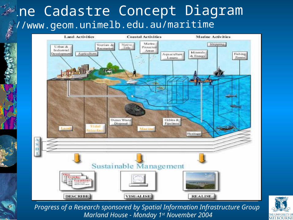
Marine Cadastre Concept Diagramhttp://www.geom.unimelb.edu.au/maritime
Progress of a Research sponsored by Spatial Information Infrastructure Group Marland House - Monday 1st November 2004
Cadastral PrinciplesTenure Principles• Diverse forms of tenure exist in marine
environment• Freehold title does not exist offshore:
Ability to hold lease rights
• Focus is more on resource management akin to the management of state land
• Overlapping tenure and interests are common within the marine environment as distinct from the terrestrial environment How can overlapping tenure be spatially managed
Progress of a Research sponsored by Spatial Information Infrastructure Group Marland House - Monday 1st November 2004
Cadastral Principles
Legal Principles• Overlapping interests managed through legally
defined boundaries• Boundaries are described within statutory
legislation, along with associated rights, restrictions and responsibilities
• Marine stakeholders must attain knowledge of boundaries in which they operate
• Stakeholders need clear legal and spatial knowledge of rights
Progress of a Research sponsored by Spatial Information Infrastructure Group Marland House - Monday 1st November 2004

Cadastral Principles
Legal Principles• Legislative framework that governs land
administration processes upholds standards relating to the resolution of land ownership including boundaries
• Marine legal framework describes the actual location of boundaries
• Maritime boundaries need to be geo-referenced• Need for standards in relation to the description of
boundaries within legislation
Progress of a Research sponsored by Spatial Information Infrastructure Group Marland House - Monday 1st November 2004
Cadastral Principles
Institutional Principles• Boundaries described within legislation need to be
visualised – linked to spatial data• Sectoral management arrangements have evolved
due to lack of overarching marine management framework
• No standards for the compilation, collation, up-dating and access of spatial data
• Spatial data exists within ‘data silos’• Data needs to become interoperable and available
to all agencies within the marine environment
Progress of a Research sponsored by Spatial Information Infrastructure Group Marland House - Monday 1st November 2004
Cadastral Principles
Institutional Principles• Centralised governing body
National Oceans Office (Commonwealth) No central body within each state
• Public and private partnerships Cadastre is part of the basic infrastructure of a country
and should be the responsibility of the government Lack of partnerships between the private sector and
government
Progress of a Research sponsored by Spatial Information Infrastructure Group Marland House - Monday 1st November 2004
Spatial Data Infrastructure
• Development of ASDI well underway in the terrestrial environment
• Impediments to ASDI in the marine environment: Immature institutional arrangements Lack of overarching government department to
coordinate spatial data
• Advantages: Aid in the creation of partnerships Provide standards and interoperability of technology
and data Ensure the compatibility of the marine cadastre to the
terrestrial cadastre
Progress of a Research sponsored by Spatial Information Infrastructure Group Marland House - Monday 1st November 2004
Conclusion
Cadastral Principles: Policy and institutional aspects are the most
applicable to the marine environment due to the physical difference in environment not being a primary impediment
Ability to apply tenure and legal principles not as easy, due to the limitation in the need for private transactions in the marine environment
Progress of a Research sponsored by Spatial Information Infrastructure Group Marland House - Monday 1st November 2004
Conclusion
• Marine Cadastre is a spatial boundary management tool, which describes, visualises and realises spatial boundaries and associated rights, restrictions and responsibilities in the marine environment.
• Will create a national marine initiative through the implementation of the ASDI.
• Task now is to develop the tools which will facilitate the implementation of such a marine cadastre.
Progress of a Research sponsored by Spatial Information Infrastructure Group Marland House - Monday 1st November 2004
Project 3.1Concepts and Principles of Virtual Australia
• Project based within Program 3 – Spatial Information System Design and Spatial Data Infrastructures
• Project being undertaken in conjunction with 8 project partners including DSE
The development of Virtual Australia aims to provide an enabling environment in which spatial based applications and user
communities can flourish.
• This project will include not only technology, but also organisational incentives, procedures and people – creating strategic value in developing a framework for VA. This will enhance the capability of government, the private sector and the general community to engage in systems based, integrated and holistic decision making about Australia.
Importance to Australia
Thankyou
http://www.geom.unimelb.edu.au/maritime/http://www.crcsi.com.au
Recommended