Embed Size (px)
Citation preview

Commissioned by:
Marine
Cadastre
in Europe a preliminary study
Brief edition
January 2017

Disclaimer
The study has been commissioned by the 5 Common Vision Partners1 (PCC, EULIS, ELRA, CLGE,
Eurogeographics) and authored by the members of a project team with experts engaged from the
Common Vision Partners or volunteered to participate during the course of the project.
The study is a property of the 5 Common Vision Partners and may not be reproduced, distributed or
used by any means, or in any form, without the 5 Common Vision Partners prior permission.
1 Hereinafter are referring as “Common Vision Partners” due to the Common Vision Agreement, signed in 2012 in
Cyprus and renewed in Lithuania in 2014, to support all European countries to achieve full coverage and high – quality,
transparent and accessible data on land.
About the sponsors
CLGE is the leading organization representing the Surveying Profession in
Europe.
ELRA is an International Association without lucrative purposes representing
Land Registrars in Europe.
EULIS is a European Economic Interest Group (EEIG), responsible for the
EULIS-portal and governed by members, providers of authoritative land and
property information in its own country or region.
EuroGeographics is a European non – profit Association of the European
cadastre, land registry and national mapping authorities.
PCC is an organization that joins together the Cadastral institutions of the EU
countries.

Table of contents
Foreword 5
Study objective 6
Introduction 7
1. The international context 10
2. EU’s policy and regulatory framework 16
3. The State of Play 23
4. Main conclusions and way forward 27
Epilogue: Rationale and contours of Marine Cadastre 31
Annex 35
Appendices 36

“The objective of this
preliminary study is to raise
awareness about the topic of
the Marine Cadastre and to
trigger the discussion about its
potential benefits in Europe’s
Blue Economy.”

Foreword
Dear Reader,
Throughout human history considerable efforts and resources have been directed at effectively managing
land whereas the marine environment has been given a lower priority. However over 70 percent of the
planet's surface is covered by water, the majority of which is in the world's seas and oceans. It’s also known
that oceans, seas and marine resources support human well-being by contributing to poverty eradication,
food security, the creation of sustainable livelihoods and jobs, human health and protection from natural
disasters. Half of the world's population lives within 60 km of the sea and over 3 billion people depend on
marine and coastal resources for their livelihoods while three-quarters of all large cities are located on the
coast. At least 90% of the volume of global trade is seaborne and approximately 50% of all international
tourists travel to coastal areas. The ocean is valued at more than US$24 trillion while the annual “gross
marine product” totals at least US$2.5 trillion, which when ranked among national GDPs makes the ocean the world’s seventh largest economy (WWF, 2015).
On the other hand, oceans and seas are also a valuable asset for the European Union (EU). Europe is a
peninsula with 70 000 km of coastline, surrounded by many islands, by four2 seas and two oceans3. This
geographical feature means that over two thirds of the EU’s borders are coastal4 (EC,2006) while the EU
Member States exercise collectively jurisdiction over the largest exclusive economic zone in the world
comprising of more than 20 million km2. The impact of the maritime sector on the EU’s economy is vital as
well: the EU’s maritime economy alone employs more than 3.6 million people, creates a gross added value
of just under €500 billion per year, with a high potential for further growth. Europe is and will be increasingly
dependent on oceans for the provision of fish protein, minerals and renewable energy. The EU’s single
market is the largest market for fisheries products in the world. 90% of the EU’s external trade and 40% of internal trade is carried on sea routes.
The five leading European organizations dealing with Cadastre, Land Registry, Mapping and Surveying issues
(CLGE, ELRA, EULIS, Eurogeographics, PCC) acknowledge the great potential of the Blue Economy in Europe
as well as the impact of efficient planning and a better allocation of human activities in the sea and their
interrelation to a sound registry system as a basis for legal certainty. These organizations decided in June
2014 in Athens, Greece to join forces to collectively better understand the Marine Cadastre concept and its
role. In this regard, a project team consisting of experts either affiliated with the 5 Common Vision Partners
or with universities and institutes in EU Member States, was founded to carry out a preliminary study, with
an orientating character, aiming at reviewing the status of the Marine Cadastre across the European Union.
We hope you will find this report, within the context of its orienting character, informative and useful for the initiation of the discussion in the European continent about the potential benefits of the Marine Cadastre in
boosting the EU’s Blue Economy and we look forward to your feedback.
On behalf of the expert team5
Rik Wouters Evangelia Balla
Project Team Coordinator Lead Author-Editor of the Brief Edition
2 the Mediterranean, the Baltic, the North Sea, and the Black Sea
3 Atlantic and Artic
4 23 out of 28 EU countries have a coastline whereas the EU's coastline is 7 times as long as the US' and 4 times as long
as Russia's 5 See Annex for all the experts in the team

Study objective and approach
Marine Cadastre in Europe
5
Objective
The objective of this preliminary study is to raise awareness about the topic of the Marine Cadastre and to
trigger the discussion about its potential benefits for Europe’s Blue Economy.
Approach
In order to meet the objective of raising awareness and stressing the need for action on investigating further
the potential benefits of the Marine Cadastre in the Blue Economy, the project was based on primary and
secondary research criteria and encompassed three major tasks. The first task included the design and
dissemination of a questionnaire through communication channels of the 5 Common Vision partners to
national experts. The second task included the documentation of the current legislative and policy
framework of the European Union as well as of related EU’s initiatives and tools to support maritime
policies. The third task encompassed the analysis and synthesis of relevant research, data and information
on the topic of the Marine Cadastre worldwide.
Desk-based research
In order to analyze the international and European context as well as to understand the conceptual
boundaries and content of the Marine Cadastre, we performed a desk-based research. A complete reference
list of sources is included at the end of this report. We reviewed various literature sources such as related
academic articles, the FIG publication No 36 for Administering Marine Spaces, the UNCLOS Convention and
multiple European Policy papers, Regulations, Recommendations and Directives related to the maritime
domain.
Limitations
As with Land Cadastre, the development of a Marine Cadastre is inevitably a complex and challenging endeavor, which requires solid investigations and thorough planning. However, it was out of the scope of
this study to provide definite recommendations and conclusions on the design and development of a Marine
Cadastre or provide evidence on direct links between Marine Cadastre and the Blue Economy and solid
documentation on its’ economic effects. This kind of research requires inevitably a different methodological
approach as well as organization and implementation of such a project. Instead the current study focused on
the identification of the field area in Europe, reaching high level conclusions from the analysis of the current
state and proposing initiatives that could provide further insights at a European and national level.

Introduction
Marine Cadastre: Definition and Scope
Marine Cadastre in Europe
6
The concept of a “Marine Cadastre” and the need to “build a marine regulatory system and a cadastre that
underpins offshore rights and responsibilities and sensibly matches its onshore counterpart” (Robertson et al.,
1999) became apparent in in late nineties’ when awareness of the importance of marine natural resources
and the recognition of the actual and potential value of a marine environment as an economic resource, led
to increased competition for its’ management. Important drivers are considered the enforcement of the
United Nations Convention on the Law of the Sea (UNCLOS) in 1994, the rise of the environmental
movement after the Rio Summit in 1992 and the continuous development of Spatial Data Infrastructures (Balla, 2015).
In the above context, the concept of a Marine Cadastre has attracted interest from several researchers from
the geomatics community, as a means to improving the administration of marine and coastal spaces through
decision support systems, and lead to increased research efforts towards the development of marine
cadastre in various jurisdictions (Sutherland M., 2011).
Following the rise of several research initiatives and pilot projects on the topic of Marine Cadastre, several
definitions have been given in the attempt to conceptualize its notion and its content. In this regard, and
according to one of several definitions that have been given to the topic. The Marine Cadastre is “a system
to enable the boundaries of maritime rights and interests to be recorded, spatially managed and physically
defined in relationship to the boundaries of other neighboring or underlying rights and interests.” (Robertson, 1999).
A second important term, along with the notion that a Marine Cadastre as with Land Cadastre, is the idea of
the marine or sea cadastre parcel which is defined as (De Latte, 2016):
• The volumetric reality of every distinct marine zone (sea surface & water column & seabed or soil &
subsoil) with: a) the rights and charges under UNCLOS b) the patrimonial rights which include rights in
rem and
• A fourth dimension, meaning the temporary nature of many particular rights (fixed terms licenses,
concessions and leases for mining, production of energy, aquaculture, fishing, etc.).
Figure 1: the concept of the Marine Cadastre
Source: http://coinatlantic.ca/index.php/indicators-
and-icom/marine-spatial-planning

Introduction
Marine Cadastre and Land Cadastre: Is there an analogy?
Marine Cadastre in Europe
7
A considerable portion of the conducted research on Marine Cadastre considered the similarities and
differences between the Marine Cadastre and its counterpart on land. Most of them converge on the fact
that the marine environment has unique features that does not apply in the case of the terrestrial
environment and therefore to the Land Registry and Cadastre (Binns et.al, 2004, Collier et. al 2003, Widodo
M., 2003) though many of the cadastral components such as adjudication, survey, owner rights have a
parallel condition in the ocean (Neely, 1998).
Specifically, as regards the similarities, related research (Tamtomo, 2004), argues that as in the land cadastre, the marine cadastre has also been built based on three pillars or benchmarks, as follows:
a) the legal pillar (3R: rights, restrictions, and responsibilities); As a part of the legal system (legal
cadastre), the marine cadastre provides legal certainty to sea-space development planning, sea parcel
rights and leases, and public access to and from the seas.
b) the technical pillar (surveying, mapping, and spatial infrastructure). As regards the technical pillar, a
marine cadastre is designed as a tool and mechanism for providing data and information as a resource
for planning and the decision making process, and as legal evidence of a certain sea and marine rights
and lease.
c) the institutional pillar (formal and informal institutions and human resources). The marine cadastre, as
part of a public administration system, acts as a public service provider and sea-conflicts resolution.
The following differences between the Marine and the Land Cadastre are the most popular ones according
to related academic papers (Collier et.al, 2001, Binns et.al. 2004, FIG, 2006):
� There are virtually no rights of full ownership or exclusive use in marine space
� Ordinary land demarcation techniques cannot apply in the marine environment: Marine boundaries are
delimited, not demarcated, and generally there is no physical evidence of “offshore” boundary.
� In the marine environment is common the existence of multiple (overlapping) rights in a single area
� The marine environment is three dimensional – classical 2D simplifications will not suffice.
� Rights can vary with time, adding a fourth dimension to the spatial data.
� The baseline to which many maritime boundaries are related is ambulatory.
The above issues are influencing inevitably the design and development of a Marine Cadastre and are
creating new challenges for the involved professionals and related stakeholders. Furthermore, it has been
stressed that as with land administration systems which are strongly related to national laws and specific
socioeconomic environments and institutional arrangements, it is impossible to adopt a marine cadastre
model from one jurisdiction and apply it to another jurisdiction since the concept of a Marine Cadastre is
unique for a specific jurisdiction regarding to its characteristics, stakeholders and legal institutional aspects
(Collier et.al, 2001).

Introduction
Marine Spatial Data Infrastructure (MSDI)
Marine Cadastre in Europe
8
Closely related to the concept of the Marine Cadastre, is the notion of the Marine Spatial Data
Infrastructure (MSDI). According to the International Hydrographic Organization (IHO, 2011), “Marine
Spatial Data Infrastructure (MSDI) is the component of an SDI that encompasses marine geographic and
business information in its widest sense. This would typically include seabed topography, geology, marine
infrastructure, resources utilisation, administrative and legal boundaries, areas of conservation, marine
habitats and oceanography” (IHO, 2011). MSDI places emphasis on the unlocking of hydrographic and all the
other marine geospatial information”.
In fact, the Marine Cadastre is considered as a base layer of a MSDI with fundamental information relating
to maritime boundaries and associated rights and responsibilities, regularly updated and maintained (FIG,
2006). The role of the Marine Cadastre as a data layer in a marine SDI has been addressed in the
international workshop on Administering the Marine Environment held in Malaysia in 2004. The workshop
recommended, in an analogy to a “Land Administration System”, to adopt the term “Marine Administration
System” for the “administration of rights, restrictions and responsibilities in the marine environment with the
spatial dimension facilitated by the Marine SDI. The workshop further recommended that “a Marine
Cadastre is defined as a management tool which spatially describes, visualizes and realizes formally and
informally defined boundaries and associated rights, restrictions and responsibilities in the marine
environment as a data layer in a marine SDI, allowing them to be more effectively identified, administered
and accessed (PCGIAP-WG3 2004)”. In order to avoid management gaps in the coastal zone, the workshop
promoted the idea of a seamless SDI that includes data from land, coast and marine environments to enable
the access and sharing of data between those environments to be improved.
As with Spatial Data Infrastructures, the field of the MSDI is very wide with a lot of related technological
developments and applications. However compared to SDIs, the Marine SDI has not yet taken a stance nor
the terrestrial SDI, because the subject of MSDI is still new (Tares M., 2013). Nevertheless, it has been argued
further that even though the number of MSDI themes is currently relatively small in number, it’s likely to
increase as understanding and new activities evolve in the marine environment (Tares, M. 2013).
Figure 2: The spatial dimension in the
marine environment (FIG, 2006)
Figure 3: Marine Spatial Data infrastructure
themes (Fowler et al., 2011)

1
The
International
Context

1.The international context
The United Nations Convention on the Law of the Sea
Marine Cadastre in Europe
10
As being said, the enforcement of the UNCLOS has inevitably influenced the evolution of the concept of the
Marine Cadastre. It has been argued (Schlagintweit G.) that 25 among the 330 articles of the Convention are
related to geomatics, whereas the provisions of the Convention for the subdivision of the oceans on
Territorial Seas, Exclusive Economic Zones and Continental Shelves, each with its corresponding rights and
responsibilities, has created a complex multidimensional mosaic of potential private and public interests
(Ng’ang’a et al., 2002).
The UNCLOS convention which was signed at Montego Bay (Jamaica) in1982 and came into effect on 1994
defines the rights and responsibilities of nations with respect to their use of the world's oceans and seas,
establishing guidelines for businesses, the environment, and the management of marine natural resources.
The Convention introduced a number of provisions, among them the setting of marine areas and their
respective limits, navigation, archipelagic status and transit regimes, exclusive economic zones (EEZs),
continental shelf jurisdiction, deep seabed mining, the exploitation regime, protection of the marine
environment, scientific research, and settlement of disputes.
Figure 4. Maritime zones and rights under the 1982 United Nations Convention on the Law of the Sea
(UNCLOS). (Source, Geoscience, Australia)
According to UNCLOS, the following distinct marine areas or zones, each with its own legal status and rights (assigned to the coastal state, other states and other stakeholders involved) and restrictions, are being
measured from a carefully defined baseline:
� territorial sea : is the marine area, up to a limit not exceeding 12 nautical miles, measured from baselines
determined in accordance with the Convention which encompasses air space & sea surface & water
column superjacent to the seabed & soil or seabed & subsoil
� contiguous zone – encompasses the sea surface & water column & soil & subsoil – breadth of 12 nautical
miles measured from the outer limit of the territorial sea
� exclusive economic zone (EEZ) – encompasses the sea surface & water column & soil & subsoil – breadth
of 200 nautical miles measured from the outer limit of the territorial sea

1. The international context
The United Nations Convention on the Law of the Sea
Marine Cadastre in Europe
11
� continental shelf – encompasses only the seabed and its subsoil – breadth of 200 nautical miles
(maximum of 350 miles) measured from the outer limit of the territorial seabed
� High Seas – consists only of the sea surface and the water column subjacent to the surface – beyond the
EEZ – beyond any national jurisdiction
� the Area encompassing only the seabed and its subsoil under the High Seas – beyond the outer limit of
the continental shelf – beyond any national jurisdiction.
Considering that a Marine Cadastre is referring to areas under national jurisdiction, only the Territorial Sea
and EEZ are relevant.

1.The international context
Marine Cadastre initiatives in the world
Marine Cadastre in Europe
12
Australia is one of the countries where the surveying and geomatics community has demonstrated an
increased interest for the issue of Marine Cadastre quite early. Early in 2000 a project regarding the
delimitation of maritime zones (AMBIS6) was implemented while a few years later an information system
known as Australian Marine Spatial Information System (AMSIS)7 was developed. The latter is a web based
interactive mapping and decision support system that improves access to integrated government and non-
government information in the Australian Marine Jurisdiction and provides multipurpose cadastral
information, among them about legal interests. AMSIS contains 80 layers of information displayed in themes
on Maritime Boundaries, Petroleum, Fisheries, Regulatory, Environment, Native Title and Offshore Minerals.
The data has been sourced from Geoscience Australia, other Australian government agencies and some
industry sources.
The Marine Cadastre in the United States was created to comply with the Energy Policy Act of 2005 which
provided for the development of an Outer Continental Shelf mapping initiative to assist in decision making
related to the sitting of renewable energy facilities in the continental shelf. The Marine Boundary Working
Group of the US Federal Geographic Data Committee (FGDC) developed an implementation plan called the
“multipurpose marine cadastre”. That was a project which started in 2001 with 10 agencies involved and the
first version released in 2010 (FGDC, 2010). Even though the Marine Cadastre initiative was designed initially
to support renewable energy siting on the U.S. Outer Continental Shelf, is also being used for other ocean-
related efforts. The MarineCadastre.gov portal is now an integrated marine information system with 270
datasets and provides data, tools, and support not only to the offshore renewable energy but to marine
planning communities as well. Another portal i.e. Data.gov/ocean is the national marine planning
information system called for in the National Ocean Policy which is complementary to the Marine Cadastre.
The latter is providing direct access to data for renewable energy and marine planning whereas the first
provides access to metadata for ocean, coastal, and Great Lakes data from many federal agencies.
Figures 5,6: Samples of the Marine Information portals in Australia and U.S.A
6 Australian Maritime Boundaries Information System
7 Australia’s Marine Spatial Information System

1. The international context
Marine Cadastre initiatives in the world
Marine Cadastre in Europe
13
The Marine Cadastre in Israel is a natural continuation of the Land Cadastre and it follows the same
principles and methods of implementation. Initially they applied it to the territorial waters and at a second
phase they plan to expand it to the Exclusive Economic Zone. The Survey of Israel and the Land Registry have
already finished the process of settling 16 marine cadastral blocks and an additional 13 blocks awaited final
approval. The process of implementation was smooth, fast, and at a low cost (Srebro, 2015).
Figures 7, 8: The maritime zones of Israel and the suggested marine cadastre blocks of Israel (Srebro, 2015)
Canada has developed a Marine Spatial Data Infrastructure (MSDI) which comprises one important
component of the Canadian Geospatial Infrastructure known as “Geoconnections”. Another initiative inside
CGDI is the Coastal and Ocean Information Network for Atlantic Canada (COINAtlantic), which has
implemented a coastal and ocean information network for the western North Atlantic. The initiative aims at
the provision of open access to spatial data to support integrated coastal and ocean management (ICOM) by
adopting all standards of and complying with the architecture of the CGDI (Rüh C., Bill R., 2012a). In 2008
the COINAtlantic, developed a search utility that locates marine and coastal datasets and offers the user the
option to add and display found datasets in a graphic map interface. A sub-component of the COINAtlantic
initiative was a prototype marine cadastre, using St. Margaret’s Bay, Nova Scotia, as the case study area
(Sutherland M., 2011). However Canada is still in progress with a Marine and Coastal Rights Registry (MC) as
a component of an Integrated Marine and Coastal Information System despite that between 2001 and 2008
there has been a major research interest in the marine cadastre. In addition the extension of the CGDI to the
Artic with the Canadian Arctic SDI initiative is including the development of a marine cadastre in the Artic
area.

1. The international context
Marine Cadastre initiatives in the world
Marine Cadastre in Europe
14
Related initiatives have been taken in Indonesia (Abdulharis et.al, 2008, Tamtomo, 2004, Widodo, 2002) and
in Malaysia (Abdullah, 2014). In particular these initiatives are following a key resolution that has been
adopted in the framework of the international workshop in Malaysia in 2004 from the Committee of
Cadastre in Asia and Pacific region. According to this resolution, all countries in the Asia and Pacific region
with an extensive marine jurisdiction and administrative responsibility are encouraged to include a marine
dimension in their NSDI as part of their obligation to meeting their responsibilities under the United Nations
Convention on the Law of the Sea (UNCLOS) (FIG, 2006).
Resume
From the macroscopic examination of the above case studies we could deduce the conclusion that in most of
them we observe a descriptive system focusing on physical, biological and economical aspects of the marine
environment. Only in Israel and Canada we see an (first) attempt to register facts that could be seen as
elements of a marine cadaster.

2
EU’s policy and
regulatory
framework

2. EU’s policy and regulatory framework
The EU reaffirms its maritime identity: the path from Integrated
Maritime Policy to Blue Growth
Marine Cadastre in Europe
16
On April 1st 1998 the European Union acceded to the UNCLOS, a fact which has inevitably amplified its
interest in maritime governance as well as in the administration of marine spaces under its jurisdiction. In
2005 the European Commission included in its strategic objectives for the next five years (2005-2009), the
need for an all-embracing maritime policy (EC, 2005). The concept of an Integrated Maritime Policy (IMP) of
the European Union became officially apparent in the European policy in 2006 with the Green Paper
“Towards a future Maritime Policy for the Union: A European Vision for the oceans and seas” (EC, 2006). It
was the first time that the land based mentality of EU Policies was reversed symbolizing that Europe is and
has always been above all a maritime nation (EESC, 2007). The Green Paper examined factors influencing
EU’s competitiveness: the state of the marine environment, scientific knowledge in all areas relating to the
oceans, innovation and the expertise of the workforce and inaugurated a consultation process which lasted
one year. Building on this valuable input and the conclusions of the consultation (EC, 2007a), the European
Commission presented on 10 October 2007, its vision for an Integrated Maritime Policy for the European
Union, also known as the Blue Book (EC, 2007b).
The Integrated Maritime Policy aspires to bring a holistic approach for the coordination of the EU sea-related
policies which have been developed separately without taking into account the broader links among them.
The Blue Book (or Blue Paper) laid the foundation for the governance framework and cross-sector tools
necessary for an EU Integrated Maritime Policy. As regards the tools for integrated policy-making, the Blue
Book distinguished three horizontal planning tools of major importance that cut across sea-related sector
policies and support joined up policy making:
� maritime surveillance which is critical for the safe and secure use of marine space;
� maritime spatial planning which is a key planning tool for sustainable decision-making;
� and a comprehensive and accessible source of data and information.
The Blue Book highlighted the inefficiency of existing planning frameworks that address the emerging
challenges from the growing competing uses of the sea8. The Commission proposed to set up a maritime
spatial planning, as a fundamental tool for the sustainable development of marine areas and coastal regions,
and for stronger use of Integrated Coastal Zone Management (ICZM), following the 2002 EU’s
Recommendation9.
Moreover, the Commission recognized that the establishment of an appropriate marine data and
information infrastructure, as a basis for strategic decision making on maritime policy, is of utmost
importance, given the vast majority of data collected and stored all over Europe for a wide variety of
purposes. This data should be compiled in a comprehensive and compatible system, and made accessible as
8 i.e. maritime transport, fishing, aquaculture, leisure activities, off-shore energy production and other forms of sea bed exploitation
9 2002/413/EC

2. EU’s policy and regulatory framework
The EU reaffirms its maritime identity: the path from Integrated
Maritime Policy to Blue Growth
Marine Cadastre in Europe
17
a tool for better governance, expansion of value-added services and sustainable maritime development.
Having awareness of such a significant undertaking that would need to be developed over a period of years,
according to a clear and coherent plan, the Commission committed to proceed, in 2008, towards a European
Marine Observation and Data Network (EMODNet) and further to promote the multi-dimensional mapping
of Member States’ waters, in order to improve access to high quality data.
The notion of the Blue Growth appeared in 2012 and is considered as the extension or the 2nd phase of the
IMP so as to contribute to the achievement of Europe’s 2020 strategy goals for smart, sustainable and
inclusive growth (EC, 2012b). The EU’s blue economy represents roughly 5, 4 million jobs and generates a
gross added value of almost a €500billion per year whereas further growth is possible in a number of areas.
The sectors of the EU’s Blue Economy identified with high potential for growth are the following: 1) Blue
energy, 2) Aquaculture, 3) Maritime, coastal and cruise tourism 4) Marine mineral resources and 5) Blue
biotechnology
Blue Growth is the long term strategy to support sustainable growth in the marine and maritime sectors as a
whole having regard that seas and oceans are drivers for the European economy and have great potential for
innovation and growth. It is the maritime contribution to achieving the goals of the Europe 2020 strategy for
smart, sustainable and inclusive growth.
Among the initiatives designed to reinforce the efforts of Member States for a successful blue economy, the
Blue Growth policy indicated the maritime spatial planning, the “Marine Knowledge” initiative, and the
Common Information Sharing Environment for the surveillance of the EU maritime domain.
These initiatives, which have been developed under the EU’s Integrated Maritime Policy and constitute
hereinafter the essential components of the Blue Growth strategy, will provide knowledge, legal certainty
and security in the blue economy and underpin and reinforce other existing instruments at a sea-basin and
EU scale.

2. EU’s policy and regulatory framework
EU’s initiatives to support Blue Growth
Marine Cadastre in Europe
18
Maritime Spatial Planning10
and Integrated Coastal Zone Management
Coastal areas11 play a vital role in the European economy while they concentrate on a significant part of the
EU’s population, the majority of the main urban centers, a large variety of human activities (e.g. tourism,
recreation, holiday housing, fisheries and aquaculture) and most transport and communication infrastructure
facilities. The intensive pressures resulting from the concentration of the abovementioned activities and
infrastructures often create threats for coastal ecosystems and natural resources while they also generate
conflicts of incompatible uses in the same or adjacent coastal areas.
In this regard, the EU has promoted variously the concept of Integrated Coastal Zone Management (ICZM)
to be implemented by Member States as a tool for the integrated management of all policy processes
affecting the coastal zone, and to further address land-sea interactions of coastal activities in a coordinated
way with a view to ensuring the sustainable development of coastal and marine areas. In 2002 the European
Commission issued a Recommendation (2002/413/EC) which laid down specific principles that the Member
States should follow to ensure sound coastal zone management. In 2010 the European Union (Decision
2010/631/EU) ratified the Protocol on Integrated Coastal Zone Management in the Mediterranean to the
Barcelona Convention (the ICZM Protocol). The Protocol, which entered into force in 2011 as a mixed
agreement, covers issues that fall within both EU competence and the national competence of the Member
States. The ICZM is predicted also diversely in other Regional Sea Conventions such as the Helsinki
Convention for the Baltic Sea Region (HELCOM) or the Bucharest Convention for the Black Sea.
The Maritime Spatial Planning (MSP) aims to address the increasing competition between sectoral maritime
interests (e.g. shipping and maritime transport, offshore energy, ports development, fisheries and
aquaculture) and environmental concerns, providing a framework for arbitrating between competing human
activities and managing their impact on the marine environment and thus enhancing decision making.
Therefore, the use of MSP would enhance the competitiveness of the EU’s maritime economy, promoting
growth and jobs in line with the Lisbon agenda and would provide a basis for simplified permit systems and
reduce costs of regulatory and administrative procedures. It would also provide a transparent and reliable
planning framework (EC, 2008).
Maritime Spatial Planning is about planning when and where human activities take place at sea – to ensure
these are as efficient and sustainable as possible.
A proposal for a Directive13 to establish a framework for MSP and ICZM was circulated on March 2013 (EC,
2013). However the text of the Directive (2014/89/EU) adopted by the European Parliament in April 2014
contained only the MSP component, along with a general stipulation which states that maritime spatial
10
In this section only the most related, i.e. Marine Knowledge and Maritime Spatial Planning, with the concept of the
Marine Cadastre, EU’s initiatives are being presented. 11
The estimated length of the EU’s coastline is almost 70,000 km including the four French overseas departments
(French Guiana, Guadeloupe, Martinique, Réunion) which are an integral part of the European Union, but excluding the
French overseas collectivities and territories, which are not part of the European Union.

2. EU’s policy and regulatory framework
EU’s initiatives to support Blue Growth
Marine Cadastre in Europe
19
planning “should take into account land-sea interactions.” The inclusion of the Integrated Coastal Zone
Management in the relevant Directive 2014/89/EC even though initially perceived, along with Maritime
Spatial Planning as a cornerstone of Blue Growth and Integrated Maritime Policy has been hindered due to
competency issues among EU and Member States.
According to the relevant Directive (Article 3) ‘maritime spatial planning’ means a process by which the
relevant Member State’s authorities analyse and organise human activities in marine areas to achieve
ecological, economic and social objectives. The maritime spatial plans shall identify the spatial and temporal
distribution of relevant existing and future activities and uses in the Member States marine waters such as
aquaculture and fishing areas, installations and infrastructures for the exploration, exploitation and
extraction of oil, gas and other energy resources, minerals and aggregates, maritime transport routes and
traffic flows, military training areas, submarine cable and pipeline routes, underwater cultural heritage etc.
(Article 8).
With a view to ensuring that maritime spatial plans are based on reliable data and to avoid additional
administrative burdens, the Member States are recommended to make use of the best available data and
information by encouraging the relevant stakeholders to share information and by making use of existing
instruments and tools for data collection, such as those developed in the context of the Marine Knowledge
2020 initiative and the Inspire Directive (2007/2/EC) (Preamble, point (24), Directive 2014/89/EU ).
According to the provisions of the new Directive, the Member States must transpose the new rules into their
national laws by 18 September 2016, and draw up national maritime spatial plans by 31 March 2021.
Marine Knowledge 2020
Central to the Marine Knowledge strategy stands the European Marine Observation and Data Network
(EMODnet), which is a single entry point for accessing and retrieving marine data maintained by agencies,
public authorities, research institutions and universities throughout the EU and embraces the full cycle, from
initial observation through interpretation, processing and dissemination. The development of the EMODnet
aims to cover the huge gaps in marine data collection and management across Europe and provide a
functional tool for marine spatial planning and better maritime surveillance.
The design of the development of EMODnet data infrastructure follows a stepwise approach in three major
phases. Currently EMODnet is in the 2nd phase of development (2013-2016) with 8 sub-portals in operation
that provide access to marine data from the following themes: bathymetry, geology, physics, chemistry,
biology, seabed habitats, human activities and last coastal Mapping as a new thematic area still in its early
Marine Knowledge enshrines basic principles such as “collect data once and use them for many purposes”
and “data should be interoperable, accessible and free of restrictions on use”

2. EU’s policy and regulatory framework
EU’s initiatives to support Blue Growth
Marine Cadastre in Europe
20
development phase. In the last phase of EMODNET is envisioned to deliver sustainable digital mapping of
European sea-beds by 2020.
The most relevant data related to a Marine Cadastre are recorded under the theme of “Human Activities” in
the EMODnet portal. The main objective of EMODnet Human Activities is to make information available on
the geographical position, spatial extent and attributes of a wide array of marine and maritime human
activities12 throughout Europe. The portal allows users to view, query and download data and metadata from
public and private sources – from throughout Europe - via a single entry portal.
The Copernicus Marine Environment Monitoring Service (CMEMS) which provides regular and systematic
reference information on the physical state, variability and dynamics of the ocean and marine ecosystems
for the global ocean and the European regional seas can be regarded as complementary to the EMODnet for
the attainment of the Marine Knowledge objectives.
INSPIRE
The INSPIRE Directive (2007/2/EC) which entered into force on May 2007 establishes an infrastructure for
spatial information in Europe to support Community environmental policies, and policies or activities which
may have an impact on the environment. The INSPIRE is based on the infrastructures for spatial information
established and operated by the Member States. The Directive includes three annexes that list 34 data
themes that define the scope of INSPIRE. Examples of data themes of relevance to the marine community
include - but are not limited to - Coordinate reference systems, geographical grid system, Hydrography,
Protected sites, Area Management/Restriction/Regulation Zones and Reporting Units, Bio-geographical
Regions, Elevation (which includes bathymetry and shorelines), Environmental monitoring facilities,
Habitats and Biotopes, Sea regions, and Oceanographic geographical features (JRC, 2015). Even though that
differences have been tracked between INSPIRE and EMODnet in terms of scope, policy frameworks and
technologies, it seems that the “Human Activities” portal of the EMODNet is relevant to the INSPIRE themes
(INSPIRE cluster) “Topographic and Cadastral Reference” and “Facilities, utilities and public services”
according to a draft conceptual mapping between INSPIRE themes and EMODNet topics made by the
Working Group Data Information and Knowledge Exchange (DIKE) (JRC, 2015). The closer alignment and
interoperability between EMODnet and INSPIRE is currently an issue of discussion among the experts
working on these two initiatives at European level.
12
Covers geographical information on aggregate extraction, dredging, fish catches, hydrocarbon extraction, major
ports, mariculture, ocean energy facilities, telecommunication cables, protected areas, waste disposal (solids, including
dredge material, dumped munitions, marine constructions), wind farms, and other forms of area
management/designation. Additional information that is anticipated to be added soon includes the status of bathing
waters, offshore installations, and hydrocarbon licenses and bidding blocks
2. EU’s policy and regulatory framework
EU’s initiatives to support Blue Growth
Marine Cadastre in Europe
21
European Atlas of the Seas
Another portal related to marine data is the European Atlas of the Seas13 which disseminates cartographic
information related to EU's coasts and seas both as maps and open data. The portal is maintained and
enriched by JRC with the support of DG MARE. It offers an up-to-date and diverse range of information
about Europe's seas, such as sea depth, underwater features, coastal regions geography and statistics, blue
energies, maritime resources, tide amplitude, coastal erosion, fishing stocks, quotas and catches, European
fishing fleet, aquaculture, maritime transport and traffic, ports' statistics, maritime protected areas, tourism,
maritime policies and initiatives, outermost regions, etc. However the information is of a general nature, not
necessarily comprehensive, complete, accurate or up to date, nor appropriate for legal advice as it is
referred specifically to its disclaimer.
Resume
Whether we consider the design of EMODnet, the outline of INSPIRE, or the set-up of the European Atlas of
the seas, striking is that no (clear) reference is made to the Marine Cadastre and the registration of rights,
titles, restrictions in a structured way.
13
http://ec.europa.eu/maritimeaffairs/atlas/maritime_atlas

3
The State of
Play
Where do the EU and the Member
States stand against the Marine
Cadastre?

3. The State of Play of Marine Cadastre in EU’s Member States
Where do the EU and the Member States stand against the Marine Cadastre?
Marine Cadastre in Europe
23
In 2015 a questionnaire intended to gather information on the state of play of Marine Cadastre in Europe
was disseminated through the communication channels of the 5 Common Vision partners to all Member
States. Answers were provided by representatives of 18 European countries: Austria, Belgium, Croatia,
Denmark, Estonia, Finland, France, Germany, Greece, Italy, Latvia, Netherlands, Portugal, Romania, Slovenia,
Spain, Sweden, and the United Kingdom.
The analysis showed that approximately one third of the responded countries have no initiatives concerning
marine cadastre, marine spatial planning or other related marine spatial data infrastructure. The other
countries have some sort of information portals concerning sea and coast or are establishing a registry only
on the coastal part. According to the answers in the questionnaire none of the countries have a full-fledged
established marine cadastre.
As regards specifically the existing Marine Data information portals in EU Member States, these are either
operative or are pilot projects. The websites providing these data are often unknown to the public and the
range of the available data is quite limited. The available marine data often concerns Seabed maps
(Bathymetry), Navigation information, Fishing rights and Coastline cartography.
One of the countries which seem to have a quite developed Marine Spatial Data Infrastructure is Germany. It
was developed as a supranational network for the integration of marine data from all relevant data sources
(Federal or State Institutions, Research organizations). The project was funded by the German Ministry of
Education and Research and a cooperation agreement between the partners for permanent operation was
made (Melles J., 2015). The portal (https://www.mdi-de.org ) provides access, visualization and search
capabilities to marine data on several themes like Human Activities, Wind Parks, Reserves, Federal
Waterways, Bathymetry, Geology etc. and is INSPIRE compliant. In Germany there is another website(
https://www.geoseaportal.de/gdi-bsh-portal/ui) which provides marine data on complementary themes
such as Spatial Planning, Shipping, Water Pollution, Marine Environment, Navigation etc. and is operating
from the Federal Hydrographic Agency of Germany (Rüh C., Bill R., 2012b).
Figures 9,10: View of the Start page of the Marine Data Infrastructure of Germany and the GeoSeaPortal

3. The State of Play of Marine Cadastre in EU’s Member States
Where do the EU and the Member States stand against the Marine Cadastre?
Marine Cadastre in Europe
24
The French National Hydrographic Service web site www.shom.fr provides bathymetry, tides and currents
data. Interesting aspects of this website are that It fulfils INSPIRE directive requirements and that it can also
display data from other portals due to standardized flows.
Figure 11: Example of display from the portal developed by the French National Hydrographic Service showing the
Morbihan Gulf with map of the coastal area, the currents and the Bathymetry
Additionally the questionnaire revealed that the existing Marine Data information portals have been
developed in most of the cases without active involvement of the national Land Registry and Cadastre
Organizations. Exceptions to this are the cases of Denmark and Estonia. In particular the MSDI of Denmark is
being developed from the Danish Geodata Agency. In fact Denmark is demonstrating a rapid pace towards
the development of a MSDI and “expansion” of the land cadastre to the sea territory. Specifically with regard
to the MSDI, in 2015, together with 10 other agencies, the Danish Geodata Agency initiated the
implementation of a Danish MSDI. The aim of establishing a Danish MSDI is to make marine spatial data
easily accessible and available for comparison and exchange across the maritime authorities for various
purposes. In addition, the idea is that the MSDI will be able to provide information on the data in question
(metadata), e.g. when the data was collected and updated, how the data can be accessed, the quality hereof
and so on. The MSDI will be implemented and authoritative data and associated services will be made
available during the period 2015-2016 (http://eng.gst.dk/danish-hydrographic-office/msdi/). The Danish
Geodata Agency is also responsible for collecting, managing and publishing hydrographic data, including
nautical charts and nautical publications and as of 2016, will also have responsibility for registering buildings
on the sea territory in the Danish cadastre. These will be registered as simple polygons, at sea mostly in
relation to offshore wind turbines and similar structures.
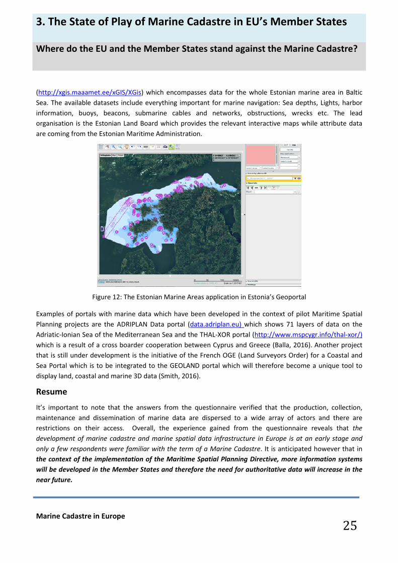
In Estonia the “Geoportal” of the Estonian Land Board hosts a specific “Marine Areas Application”
3. The State of Play of Marine Cadastre in EU’s Member States
Where do the EU and the Member States stand against the Marine Cadastre?
Marine Cadastre in Europe
25
(http://xgis.maaamet.ee/xGIS/XGis) which encompasses data for the whole Estonian marine area in Baltic
Sea. The available datasets include everything important for marine navigation: Sea depths, Lights, harbor
information, buoys, beacons, submarine cables and networks, obstructions, wrecks etc. The lead
organisation is the Estonian Land Board which provides the relevant interactive maps while attribute data
are coming from the Estonian Maritime Administration.
Figure 12: The Estonian Marine Areas application in Estonia’s Geoportal
Examples of portals with marine data which have been developed in the context of pilot Maritime Spatial
Planning projects are the ADRIPLAN Data portal (data.adriplan.eu) which shows 71 layers of data on the
Adriatic-Ionian Sea of the Mediterranean Sea and the THAL-XOR portal (http://www.mspcygr.info/thal-xor/)
which is a result of a cross boarder cooperation between Cyprus and Greece (Balla, 2016). Another project
that is still under development is the initiative of the French OGE (Land Surveyors Order) for a Coastal and
Sea Portal which is to be integrated to the GEOLAND portal which will therefore become a unique tool to
display land, coastal and marine 3D data (Smith, 2016).
Resume
It’s important to note that the answers from the questionnaire verified that the production, collection,
maintenance and dissemination of marine data are dispersed to a wide array of actors and there are
restrictions on their access. Overall, the experience gained from the questionnaire reveals that the
development of marine cadastre and marine spatial data infrastructure in Europe is at an early stage and
only a few respondents were familiar with the term of a Marine Cadastre. It is anticipated however that in
the context of the implementation of the Maritime Spatial Planning Directive, more information systems
will be developed in the Member States and therefore the need for authoritative data will increase in the
near future.

4
Main
conclusions
and way
forward

4. Main conclusions and way forward
Main conclusions
Marine Cadastre in Europe
27
1 Several jurisdictions outside of the European continent, with strong ocean and
sea interests, have shown a rapid pace towards the development of the Marine
Cadastre since 1994, when the UNCLOS came into effect. Our review of the existing literature and implemented projects revealed that the geomatics
community (state agencies, professionals and academia) have demonstrated an intense interest
to apply land administration techniques to the marine environment in several regions (i.e.
Australia, USA, Canada etc.) quite earlier than Europe. Following this interest, several
sophisticated web mapping services have been developed based on open and re-use data policies and the concept of the Multipurpose Cadastre. However the majority of the existing
projects present a lack of a real marine cadastral registration component appropriate for secure
process for transfer of titles, establishment of mortgages etc.
2
Land cadastre is partially a good analogy to the Marine Cadastre. Tough principles of the land cadastre might be similar to that of the marine cadastre however
we do see differences. We have surely seen and we can use the analogy with the land cadastre,
if it comes to the system for registration. On the other hand the legal framework differs and the
dynamics are entirely different: limited amount of sea parcels and limited amount of
transactions. This affects the solution and appearance of the marine cadastre.
3 The Marine Cadastre is a base layer of the Marine Spatial Data Infrastructure
offering fundamental information relating to maritime boundaries and
associated rights and responsibilities, regularly updated and maintained. However the study identified that the MSDI is at an early phase in Europe. It is anticipated
though that as the need for boosting the 5 sectors of the Blue Economy gains increased focus at
the EU level, more information systems will be developed in the Member States. Subsequently,
the need for authoritative data relating to boundaries and spatial extents of rights associated
with human activities in the sea will increase in the near future.
4
Marine Cadastre is not Maritime Spatial Planning but it’s the most important
underpinning data sources to enable its implementation. The growing emerging concept of Maritime Spatial Planning since mid-2000 both in academic research as in implemented projects has created misconceptions with Marine Cadastre. As we
have seen from our survey, many people refer to Marine Cadastre when they have MSP in their
minds. Therefore conceptual clarifications are needed: Marine Cadastre is not Maritime Spatial
Planning. MSP is a process determining where and when human activities happen in the sea. The
Marine Registry and Cadastre is a system providing all the necessary information (who, how,
where) about the 3R’s (rights, restrictions, responsibilities) associated with human activities on
the marine environment. In fact the Marine Cadastre provides the most important underpinning
data sources to enable MSP implementation since the process of planning requires the
knowledge of boundaries and related cadastre information. Therefore Marine Cadastre can
facilitate decisively the process of MSP.

4. Main conclusions and way forward
Main conclusions
Marine Cadastre in Europe
28
5
The EU relevant policy framework recognizes the necessity to attain “legal
certainty” in the marine environment. However it is the cross cutting tool of the Maritime Spatial Planning which has been identified as
the most appropriate to achieve legal certainty for all stakeholders in the maritime arena, to
enhance the investment climate in Blue Economy Sector and to reduce transaction costs. The study identified further that there is no kind of reference to the notion of “Marine Cadastre” in
the EU’s legal framework. Instead, the “spatial dimension” on the administration of the marine
environment is being reflected in the 2014/89 EC Directive (MSP), though without any explicit
link to the rights which are associated with the human activities in marine areas. The same
applies to national legal frameworks where only a few cases were identified with specific
reference to registrations in the sea environment.
6
The most relevant data to a Marine Cadastre are recorded under the theme of
“Human Activities” in the EMODNET portal. However the study identified that the information provided through EMODNET portal is of a
static nature, more suitable for other purposes (e.g. statistics, planning, research), whereas the
“legal” component (validated and authoritative information about associated rights) does not
seem to be fully nor properly developed to support the “offshore property” market. The same
also applies to the “spatial” component where authoritative and updated data are needed to
secure interests, restrictions and responsibilities of Member States, industry and citizens.
7 A wide array of actors and stakeholders are involved in the management of the
marine environment and production of marine data, though the competent
national Land Registry and Cadastre organizations have been scarcely so far
engaged. The study revealed that responsibilities and jurisdictions in the marine environment
(demarcation of coastline, delimitation of marine areas, granting of rights and permits,
concessions, planning, protection) are scattered and shared over a diverse and multiple range
of actors (national authorities, institutes, organizations). The same complicated pattern exists in the production, collection, maintenance and dissemination of marine data while restrictions on
access have been detected.
8 Existing Marine Information Systems (either operative or on pilot basis) are
developed either on the concept of EMODNET or to serve other needs (ICZM
strategy, MSP, marine areas’ delimitation) but not a Marine Cadastre. The currently developed (IT) systems and information portals have a rather statistical and
descriptive nature. Apart from the fact that typical cadastral information on (ownership) rights
and restrictions is lacking, the process of actively maintaining data is not present. The
registration is a dynamic process that induces a constant updating (adding, changing, deletion)
of the registered data. The quick and easy retrieval of data is an important aspect of the IT-
system, and that is not a strong point either in EMODnet and various national portals studies.

4. Main conclusions and way forward
Way forward: Indicative areas for further action
Marine Cadastre in Europe
29
The current study is considered as preliminary and is aiming among others at detecting the extent of interest
in the topic of Marine Cadastre by the national Land Registry and Cadastre organisations, other competent
national authorities and/or European institutional bodies and administrative organs. Therefore any follow up
initiative on behalf of the 5 Common Vision Partners should be inter-related with feedback and interest that
may be expressed by national or European authorities.
Thus, a number of follow up studies that could be undertaken in a next phase is presented here:
Develop a blue print for the marine cadastre
For the preparation of a blue print, the main technical, legal, institutional and operational aspects of a
Marine Registry and Cadastre would be identified including business processes and information supply. The
issues to be investigated further include the optimal spatial boundaries (landward/seaward) of a Marine
Cadastre, the best wise approach for the design and development of a Marine Cadastre, the type of data
that should be registered, the issue of 4D rights in marine space as well as other legal aspects dealing with
multiple interests for the same space at the same time etc. and lastly the institutional aspects for the best
organisation of a Marine Cadastre within the administrative system of a country.
Carry out market study and perform user need assessment
If we have a look at the conclusions we must admit that to some extent we made assumptions on what users
really need in terms of a marine cadastre. Starting from the ideal-typical set of arguments, we need to check
what outspoken needs for a marine cadastre really exist. We need to check whether the blue economy is
indeed supported by better registration of rights and that the propose solution will work.
Prepare proposals for improvement of the EU-framework
The EU legal framework should be more directive regarding the provision of registration of rights, licenses,
concessions and all kind of restrictions. Basis for the framework should be the UNCLOS and relevant EU
Directives. In this study elements for the framework are proposed.
Prepare positioning paper for national authorities
Based on the results of this study and with additional findings from further studies we will draft a white
paper to unfold our recommendations. Whether that can be a paper that has a more general character or
that we will be able to draft a country-specific one is to be seen, and is depending on available information,
resources and time.

Epilogue: Rationale and contours of Marine Cadastre
I. Why a Marine Cadastre in Europe?
Marine Cadastre in Europe
30
The relevance of a Marine Cadastre originates from:
� The need to implement the UNCLOS thus guaranteeing and securing sovereign state rights in the sea
area: A Marine Cadastre that records obligations and restrictions deriving from the delimitation of
marine areas according to the Convention will inform all persons concerned and contribute without any
doubt to their enforcement, guaranteeing decisively the sovereign state rights. The information
contained in a Marine Cadastre relating to the patrimonial rights that exist in the territorial sea and the
EEZ waters and the soil and subsoil of these areas, will also prove very useful in that it will inform the
authorities and all other stakeholders about the legal holders (owners, lessors, users, license holders,
etc.) and exact content and location of these rights.
� The need of publicity and legal certainty in the marine environment to reduce conflicts on the
overlapping rights, interests and responsibilities: Registration is the recording of deeds relating to the
creation or transfer of rights in rem in immovable goods (or ships) or relating to charges or restrictions
encumbering immovable goods (or ships) on specific registers kept at public land or ship registries.
Registration is a legally acknowledged proof that the rights of the registered owner, beneficiary,
transferee, mortgagee etc., are protected against third parties (deed system) or that the registered
person is really legally entitled to the right (title system). Publicity and legal certainty resulting from
registration are of paramount importance for a sound real estate market and a performing credit sector,
and ultimately for a thriving economy as such. This means that the establishment of a marine cadastre
that identifies and describes the physical parcel and its boundaries, should have to be flanked by
registration in the registers of the deed creating or transferring the rights, charges or restrictions with
respect to the marine cadastral parcel.
� The need to enhance public revenues deriving from the taxation of marine patrimonial rights and
exploitation of marine resources: As with the land-based cadastre which was primarily established for
taxation purposes, likewise, a marine cadastre would lay the foundation for a fair taxation system
allowing to tax both sea-related property and sea-generated incomes. In the Exclusive Economic Zone
(EEZ), taxation on property and incomes would obviously only be possible following prior registration of
the offshore units under a national flag, ideally pursuant to international conventions concluded at the
initiative of the International Maritime Organisation (IMO) and/or of the Comité Maritime International
(CMI).
� The need to implement binding legal provisions for maritime spatial planning: The European
Commission attaches much importance to the establishment and implementation of maritime spatial
plans by Member States, with the aim of promoting sustainable growth of maritime economies,
sustainable development of marine areas and sustainable use of marine resources. A marine cadastre
that records general marine spatial planning restrictions, such as shipping routes, fishing and
aquaculture zones, disposal sites, energy atolls, corridors for cables and pipelines, nature reserves, etc.

Epilogue: Rationale and contours of Marine Cadastre
I. Why a Marine Cadastre in Europe?
Marine Cadastre in Europe
31
will inform all persons concerned and will certainly contribute to their enforcement.
� Ultimately it is anticipated that a Marine Cadastre will benefit the development and growth of a
sustainable Blue Economy.
From the study is becomes more and more clear that a Marine Cadastre can support the Blue Economy.
As we have seen with security of land tenure and/or land rights, they foster in general economic
development, especially in those sectors where large investments in constructions are required to do
business. For the priority sectors as defined in the Blue Growth programme, this will focus on
aquaculture and energy production, where large investments are needed and financial risks are
manifest.

Epilogue: Rationale and contours of Marine Cadastre
II. What inside a Marine Cadastre?
Marine Cadastre in Europe
32
As being said, it was out of the scope of this study to outline the features of an ideal Marine Cadastre or to
develop a blue print. However, as a hint to the debate about the contents of a Marine Cadastre, this section
aims to describe briefly the short of rights and restrictions to be encompassed in a Marine Cadastre. A public
registration needs to be based upon a cadastre14 that locates, delimits and describes the cadastral object and
records and indicates its use as well as all relevant public and private rights, restrictions (including inter alia
the planning restrictions) and charges on that cadastral object. Likewise, an effective registration system
regarding marine patrimonial rights, charges and restrictions can only be effective if an accurate Marine
Cadastre is established and updated according to the latest state of the art technology. To this end, actual
spatial data regarding the location and description of the maritime boundaries (the basic cadastral
information) is to be completed by the following information regarding UNCLOS rights, charges and
restrictions and the national patrimonial rights that a Marine Cadastre would take into account (De Latte,
2016b):
1. the sovereignty exercised by the coastal state
2. the public rights, responsibilities and restrictions that define the sovereignty of the coastal state according to the UNCLOS i.e.:
� the paramount right of innocent passage;
� the fishing rights in favour of other states ;
� the general marine spatial planning restrictions (e.g. shipping routes, protected sandbanks, special fishing and aquaculture
zones, areas for sand and gravel exploitation, energy atolls, areas for wind farms, corridors for cables and pipelines, disposal sites
for dredged material, extension zones for ports, sites for coastal protection, zones for military exercises, protected wrecks and
underground cultural heritage);
� protection and preservation of the marine environment ;
� conservation of living and non-living resources;
� marine scientific research;
� protection of archaeological and historical objects found at sea;
� private rights in personam based on licenses, concessions or leases granted by the coastal state to companies for exploration
and exploitation of the territorial sea (e.g. sand and gravel extraction, crude oil and natural gas extraction, mining, fishing,
aquaculture, energy production, dumping of dredging material etc.) – these rights are temporary in that they only last for the
duration of the licenses, concessions or leases;
3. public and private rights in rem (patrimonial rights)
� the overall public property of the soil and subsoil and its resources (‘public domain’ of the coastal state);
� the private property rights and other rights in rem owned by the holders of licenses and concessions with regard to:
− immovable goods (offshore units fixed to the seabed & pipelines and cables if fixed to the seabed or embedded in the
subsoil) – the property rights to these goods are temporary in that they only last for the duration of the licenses,
concessions or leases;
− movable goods (mobile offshore units & pipelines and cables lying on the seabed without being fixed to it & living and non-
living resources appropriated pursuant to the licences, concessions or leases but only for the
− duration of these licenses, concessions or leases).
14
In this context a ‘cadastral object’ means: a cadastral parcel on the seabed of the territorial sea or a delimited and geographically
described part of the seabed of the EEZ where the foundations of fixed offshore units (such as wind farm turbines, platforms for
drilling, elevating and other activities, aquaculture installations, energy production and stockage facilities, scientific research
installations) are imbedded; this ‘cadastral object’ would also include an accurate description of the fixed offshore units concerned.
Table 1: Rights and restrictions in the Territorial Sea to be registered in a Marine Cadastre

Epilogue: Rationale and contours of Marine Cadastre
II. What inside a Marine Cadastre?
Marine Cadastre in Europe
33
1. the sovereign economic rights granted under UNCLOS to the coastal state;
2. the rights, responsibilities and restrictions that define the sovereign rights of the coastal state i.e.:
� the paramount right of free navigation and overflight ;
� the right of other states to lay and maintain cables and pipelines;
� the fishing rights in favor of other states (pursuant to European or international law or bilateral agreements);
� general marine spatial planning restrictions (shipping routes & protected sandbanks & special fishing and aquaculture
zones & areas for sand and gravel exploitation & energy atolls & areas for wind farms & corridors for cables and pipelines &
disposal sites for dredged material & extension zones for ports & sites for coastal protection & zones for military exercises &
protected wrecks and underground cultural heritage);
� protection and preservation of the marine environment;
� conservation of living and non-living resources;
� marine scientific research;
� protection of archaeological and historical objects found at sea;
� private rights in personam based on licences, concessions or leases granted by the coastal state to companies for
exploration and exploitation of the EEZ (e.g. sand and gravel extraction, crude oil and natural gas extraction mining, fishing,
aquaculture, energy production, dumping of dredging material etc.) - these rights are temporary in that they only last for
the duration of the licenses, concessions or leases;
3. private rights in rem (i.e. the private property rights and other rights in rem owned by the holders of licenses, concessions or
leases. Those property rights and rights in rem or patrimonial rights exist with regard to following goods which are to be
considered as ‘movables’ ):
� fixed and mobile offshore units (artificial islands, installations and structures) – the rights to fixed offshore units are
temporary in that they only last for the duration of the licenses, concessions or leases involved. The licenses, concessions or
leases having allowed for their construction;
� pipelines and cables lying on the seabed or embedded into the seabed;
� living and non-living resources appropriated pursuant to the licences, concessions or leases but only for the duration of
the licences, concessions or leases involved.
It is obvious that Marine Cadastre is a topic of high interest to many countries in the world, in terms of
guaranteeing and securing their national interests from an economic, environmental and social point of
view. The experience gained through this study and the fact that the land cadastre in many countries is
extending to include the coastline while much of the technology that is used in land surveying is applicable
to the marine environment as well, showed us that the effective management of the marine environment
requires a multidisciplinary approach while further we understand that land and sea should be treated in a
holistic and integrated manner. To this end, we have the perception that the experience and expertise of
the 5 Common Vision partners in the fields of Cadastre, Registry, Surveying, Mapping and Spatial Data
Infrastructures should be taken into account to the new topic on the exploitation and sustainable
management of the oceans and seas of the European Union. This is a challenge for both land surveyors and
for marine industries as well, to embrace the role of surveyors as not just ‘land’ related, but having the
expertise to help spatially define and administer the marine environment l (Williamson et.al., 2005).
Table 2: Rights and restrictions in the Exclusive Economic Zone to be registered in a Marine Cadastre

Annex: The project team
Marine Cadastre in Europe
34
The following experts participated in and contributed variously to the elaboration of this
preliminary study for on the Marine Cadastre in Europe (listed in alphabetical order):
• Magdalena Andersson, Sweden, Business developer, Lantmäteriet
• Evangelia Balla, Greece, Member of the Scientific Council, NCMA S.A., PCC
• Maurice Barbieri, Switzerland, President CLGE
• Guido De Latte, Belgium, Ship Registrar, ELRA
• Gordon Johnston, UK, RICS surveyor expert
• Gerard Leenders, Netherlands, Expert EULIS / Kadaster
• Ivana Racetin, Croatia, Associate Prof, University of Split/Chamber of Chartered Surveyors
• Enrico Rispoli, Italy, Board member Consiglio Nazionale Geometri e Geometri Laureat
• Maria Scorza, Italy, staff member Consiglio Nazionale Geometri e Geometri Laureat
• Per Sörbom, Sweden, Head of section, property information management, Lantmäteriet
• Karen Schweigler, Netherlands, Management Assistant Kadaster
• Nicolas Smith, France, Vice-President CLGE
• Haico van der Vegt, Netherlands, NSDI-expert Kadaster
• Rik Wouters, Netherlands, Managing Director EULIS
• Marjana Zelic, Croatia, Expert EuroGeographics

Appendices

Appendix 1 : Status by country1)
1) The Appendix includes not all EU Member States, but only those for which information has been gathered through
the Questionnaire. For more country information you may refer to the contact persons listed in appendix 2.
Marine Cadastre in Europe
36
Austria
Not a Marine Cadastre or a Marine Data information system.
Belgium
No Marine Cadastre exists. However there is: a) a maritime spatial plan for the Belgian part of the
North Sea and b) a Belgian coastal atlas covering the EEZ of Belgium and the coastal municipalities.
The Maritime Spatial Plan was officially approved in 2014 (Royal Decree of 20th
March 2014) from the
coordinating authority which is the Ministry for health, food chain safety and environment. Another
important organization is the Ministry of Finance (General Patrimonial Documentation Administration
AGDP/AAPD) which is responsible for cadastre and land registration in Belgium). (The MSP is freely
available here http://www.health.belgium.be/en/marine-spatial-planning).
The Belgian coastal atlas was published as a response to the European Recommendation in ICZM, to
Provide an overview of the key topics for the Belgian Coast. The atlas provides interactive and
downloadable maps and data, GIS. As of 2010 has included 33 datasets of general categories (such as
geography and spatial structure, the physical environment, integrated coastal zone management, use
of sea areas, nature and environment, tourism and recreation, industry and companies, fisheries and
agriculture, architectural patrimony and culture, living at the coast, coastal defense)
Planned improvements to the Atlas include:
Updating the atlas, Providing more interactive maps, besides the static (and easy to use) maps,
Integrating sustainability indicators into the atlas, Including more marine information.
Croatia
At the moment there is no Marine Cadastre project active in Croatia, but in the past there were two
such projects (pilot project in partnership with Norway and National Real Property Registration and
Cadastre Program, known as « Organised Land »). There is an existing system for determination of the
Marine Cadastre, especially its land border (legislative and technical protocols). Its lead organization is
Ministry of Maritime Affairs which is responsible for the marine protection in the country. There is no
public web site. For the moment is not INSPIRE compliant. It concerns the marine area of the whole
Adriatic east coast of the Republic of Croatia.
Cyprus
No Marine Cadastre exists. However preparations for the implementation of the MSP Directive are
already in place. In particular, a Committee for Maritime Spatial Planning and Integrated Coastal Zone
Management has been established by the Ministerial Council since 25/07/2012. Its role is to give its
proposals about Maritime Spatial Planning (zoning all maritime activities) to decision makers. The
Cyprus Lands and Survey Department is a member of this committee and its role is to give the spatial
infrastructure for maritime planning.
In order to gain experience in Maritime Spatial Planning in 2013 a program was awarded to a
partnership from Cyprus and Greece. The program’s (THAL-CHOR) objective is to develop Maritime
Spatial Plans for a pilot area. The program ended in September 2015. It is under the auspices of the
INTERREG GRECE – CYPRUS. In Cyprus the lead organization for Maritime Spatial Planning is the
Department of Merchant Shipping and for Integrated Coastal Zone Management the leader
organization is the Department of Environment. All marine data are freely available except from
classified which are referring mainly to the marine archaeological sites. The marine data are being
collected by the Department of Lands and Surveys while the Oceanographic Centre of the University of
Cyprus is another stakeholder. There are multiple actors exercising responsibilities on marine
protection such as the Department of Environment, the Department of Merchant Shipping and the
Department of Fisheries and Marine Research.

Appendix 1 : Status by country1)
Marine Cadastre in Europe
37
Denmark
Denmark is demonstrating a rapid pace towards the development of a MSDI and “expansion” of the
land cadastre to the sea territory. Specifically with regard to the MSDI, in 2015, together with 10 other
agencies, the Danish Geodata Agency initiated the implementation of a Danish MSDI. The aim of
establishing a Danish MSDI is to make marine spatial data easily accessible and available for
comparison and exchange across the maritime authorities for various purposes. In addition, the idea is
that the MSDI will be able to provide information on the data in question (metadata), e.g. when the
data was collected and updated, how the data can be accessed, the quality hereof and so on. The
MSDI will be implemented and authoritative data and associated services will be made available
during the period 2015-2016 (see here http://eng.gst.dk/danish-hydrographic-office/msdi/ ).
The Danish Geodata Agency is responsible for collecting, managing and publishing hydrographic data,
including nautical charts and nautical publications. As of 2016, will also have responsibility for
registering buildings on the sea territory in the Danish cadastre, in conjunction with new responsibility
for registering buildings on rented property. These will be registered as simple polygons, at sea mostly
in relation to offshore wind turbines and similar structures.
The Danish Nature Agency under the Ministry of the Environment has lead responsibility, but a range
of other public bodies hold responsibilities as well for elements of marine protection (ie. coastal
planning, dredging and depth maintenance, monitoring maritime air emissions, etc.)
As regards the Open Data strategy in Denmark, the “Basic Data Programme” is an initiative under
Denmark’s Government Strategy which makes a range of public sector data freely available for public
use. The programme came into effect in January 2013 and encompasses a range of Geodata but it
doesn’t include hydrographic data. Denmark’s Ministry of Finance is responsible for the programme
and the related strategy.
Estonia
In Estonia there is not such a Marine Cadastre but there is a specific “Marine Areas Application” which
operates within the context of the “Geoportal” of the Estonian Land Board (see here
http://geoportaal.maaamet.ee/eng/ and here
http://xgis.maaamet.ee/xGIS/XGis?app_id=PRIM01&user_id=at&bbox=270365,6326119.04648526,74
1174,6705114.95351474&LANG=2). The lead organization is the Estonian Land Board which provides
the relevant interactive maps while attribute data are coming from the Estonian Maritime
Administration. It is INSPIRE compliant and it encompasses data for the whole Estonian marine area in
Baltic Sea. The available datasets are including everything important for marine navigation: Sea
depths, Lights, harbor information, buoys, beacons, submarine cables and networks, obstructions,
wrecks etc. The competent national authority for marine protection is the Estonian Maritime
Administration.
Finland
Paikkatietoikkuna (www.paikkatietoikkuna.fi) is the finnish SDI. Unfortunately, an MSDI is not available
probably due major organizational changes of breaking down the Finnish Maritime Administration in
to private companies in 2010 and the Finnish Maritime Research Center between the Finnish
Environment Institute and Meteorologial Instutute a few year earlier. The governmental Traffic
Agency has however promised that marine products will be opened ”little by little” (Traffic Agency
web page, 2013). The SDI has in any case been a success, with over 40,000,000 service requests
monthly in 2012 . The Finnish Transport Agency’s Hydrographic Office is responsible for the
hydrographic operations in Finland. The Hydrographic Office publishes electronic and printed charts of
the Finnish coastal areas and inland waterways, and maintains a chart updating service. It also
maintains a hydrographic data service and publishes information related to nautical charts.
The following web-sites provide relevant information:
http://www.liikennevirasto.fi/web/en/merchant-shipping/paper-charts#.V5es6_mLTIU
http://www.bshc.pro/services/
http://inspire.ec.europa.eu/reports/stateofplay2011/rcr11FIv12%200.pdf
http://www.paikkatietoikkuna.fi/web/en/sdi-in-finland
http://www.syke.fi/en-
us/Research__Development/Sustainable_management_of_the_Baltic_Sea_and_freshwater_resources
/Information_and_data_systems
http://www.ymparisto.fi/en-US/Sea http://www.helcom.fi.

Appendix 1 : Status by country1)
Marine Cadastre in Europe
38
France
With over 11 million km2 of marine waters, including its overseas territories, France has the second
largest exclusive economic zone in the world. France has declared an EEZ off its coasts in the North
Sea, the English Channel, and the Atlantic Ocean—but not the Mediterranean.
In France exists a Sea and Coastline portal (Portail du littoral et de la mer) which has been developed
by the “Ordre des Geometres-experts” (Smith, 2016). The portal addresses all the marine and coastal
data as well as the conflicts of “use” rights (overlapping uses, granted rights) and is INSPIRE compliant.
It’s a tool to collect all the cartographic and regulatory (zoning and associated texts) data concerning
the coastal area and the maritime public area; the sea boundaries are the territorial waters and at the
current stage of development the portal targets 2 pilot areas: one near Marseille and one near Sete (at
the Mediterranean Sea). In France it has been reported the existence of restrictions on access to
marine data and a diversity of actors which collect, manage and publish marine data or hold
responsibilities on the marine environment such as the State, Water Agencies, Nature Reserves,
IFREMER. The French National Hydrographic Service web site www.shom.fr provides bathymetry,
tides and currents data.
Germany
Marine Spatial Data Infrastructure (MDI-DE) exists already in Germany (https://www.mdi-de.org ) It
has been developed as a supranational network of for the integration of marine data from all relevant
data sources (Federal or State Institutions, Research organizations). The project was funded by the
German Ministry of Education and Research and a cooperation agreement between the partners for
permanent operation was made (Melles J., 2015). The portal (https://www.mdi-de.org) provides
access, visualization and search capabilities to marine data on several themes like Human Activities,
Wind Parks, Reserves, Federal Waterways, Bathymetry, Geology etc. and is INSPIRE compliant.
There is another website (https://www.geoseaportal.de/gdi-bsh-portal/ui) which provides marine
data on complementary themes such as Spatial Planning, Shipping, Water Pollution, Marine
Environment, Navigation etc. and is operating from the Federal Hydrographic Agency of Germany.
Greece
Greece has not developed yet a Marine Cadastre, though there is a growing awareness about the
benefits of an integrated Marine Information System which could support decisively the objectives of
the EU’s Integrated Maritime Policy in the sea basins around Greece and boost further Greece’s Blue
Economy the latter which contributes to a great part on the overall GDP of the country. In particular
there are a few research initiatives that have been taken lately towards this direction which aimed at
the development of a pilot Marine Cadastre project in the Ionian Sea (Arvanitis, Parri, 2014) and the
drafting of principles and technical specifications of a Marine Cadastral System according to the “fit-
for-purpose” theory and the specifications of the Hellenic Land Cadastre (Dimitrouli M., 2015). On
the other hand, Greece has been involved in the implementation of two Maritime Spatial Planning
transboundary Projects (ADRIPLAN and THALHOR) aimed at the preparation of the country to the
implementation of the EU Directive 2014/89 on Maritime Spatial Planning.
Responsibilities over the protection and management of the marine environment and coastal areas
and therefore to the collection, production and management of relevant marine datasets are
spreading into the scope of several ministries and governmental agencies, among them the Ministry of
Environment and Energy (YPEN), the Ministry of Shipping and Insular Policy, the Ministry of Finance,
the Hellenic Navy Hydrographic Service etc. (Balla, 2016a).
Italy
Italy has a detailed marine cadastre in telematic connection with the international infrastructure of
interchange of geographic, spatial and census data. This information concerns the Marine Areas in
Italy that extend for 7500 linear km and occupy a coastal area of over 550,000 square kilometres. The
coasts and the territorial sea are "public goods for navigation". The Coastal Territory constitutes a
particular category of public goods within the larger variety of "state property", that is, state-owned
assets. The coastal area is composed of the Maritime Domain and the Territorial Sea. In Italy, the
cartographic representation of the national territory is entrusted to the Istituto Geografico Militare of
Firenze while the cartographic representation of the sea (maritime cartography) is entrusted to the
Istituto Idrografico della Marina Militare of Genova. The update of cadastral data and the specific use
of the maritime domain are represented in the portal SID (Information System of the coastal area)
managed by the Ministry of Infrastructure and Transport. The Italian Territory, including the Maritime
one, is represented geographically by the Military Geographical Institute (IGM) which has the task of
providing a topographic support to Italian Units and Army Commands.
All information is available through the link:
http://www.agenziaentrate.gov.it/wps/content/nsilib/nsi/home/servizi+online/sid

Marine Cadastre in Europe
39
Latvia
According to the information obtained from the Questionnaire there isn’t any Marine Cadastre or
Marine Data information system in Latvia. It has been reported that Marine Data are currently scarcely
available. On state level, the competent organization is the State Environmental Service
(www.vvd.gov.lv).
Portugal
No information regarding the existence of a MC or an MSDI provided through the Questionnaire.
However additional desk research revealed that a partnership (National Land Survey from Iceland, the
Norwegian Mapping Authority, and the Portuguese Sea and Atmosphere Institute) has undertaken a
project to develop a Marine Spatial Data Infrastructure (MSDI) database to collate and harmonize
marine data spread over institutions and connect the data to geographical information, ensuring
better coordination and information sharing. MSDI will integrate technology, methodology and
scientific standards with policy and serve as a basis for decision-making.
Romania
It has been reported the absence of a Marine Cadastre or a Marine Data information system. The
competent national organization for collecting, managing and publishing hydrographic data and
nautical charts or conducting hydrographic surveys is the Maritime Hydrographic Directorate (MHD)
which is member of the IHO (International Hydrographic Organization). The MHD in addition to
supporting the safe navigation at the Black sea, underpins almost every other activity associated with
the sea, including the resource exploitation, fishing, minerals, maritime boundaries delimitation,
national marine spatial data infrastructure, coastal zone management, marine science etc.
Slovenia
In Slovenia Marine Cadastre has been established with the Water Act and covers Territorial sea waters
of Slovenia. Data (land parcel and cadastral community) are registered within land cadastre data base
at Surveying and Mapping Authority of the Republic of Slovenia (www.gu.gov.si). With the Decree on
designation of the sea fishing area of the Republic of Slovenia fishing zones were established. The
Maritime Code of the Republic of Slovenia defines internal and territorial waters and Slovenian
ecological protection zone and High Seas in Adriatic Sea. The competent national authorities for
marine protection are the Ministry of Infrastructure (Slovenian Maritime Administration,
www.up.gov.si/en ) and the National Institute of Biology (Marine Biology station Piran,
www.mbss.org). Ministry of Infrastructure is also responsible for hydrographic activities and safety of
navigation. Geodetic institute of Slovenia is responsible for collecting, processing and publishing of
hydrographic data and information, including nautical charts and publications. Ministry of the
Environment and Spatial Planning is responsible for maritime planning in the coastal area and sea
under Slovenian jurisdiction.
Spain
As regards the coastal zone, any real estate in this area is being surveyed by the Coastal Demarcation
office from Ministry of Environment, registered in the land register and being depicted on the
cadastral map. The coastal boundaries of the public maritime areas are available online on the
Environment Ministry’s website, and also from there link with the Virtual office of cadastre. An SDI
with geographic information about the marine areas exists. The available Information is related to
bathymetry, nature of the seabed, administrative, legal and marine limits, fishing areas (shoals),
artificial reefs, proposed Protected Marine Areas, marine bioregions and other environmental
parameters. The Spanish SDI initiative about land data has reached a very high level of development
and outreach, but it is necessary to make an effort to extend SDI paradigm to marine
and coastal information. The Spanish NSDI (www.idee.es)
http://www.iho.int/mtg_docs/com_wg/IRCC/EC_IHO/EC-IHO-
04/Documents/7%204th%20IHM_MSDI.pdf has a data layer about Hydrography however it seems
that the available data are related to inland waters. The Spanish Hydrographic Institute as of 2013 was
planning to provide Web Mapping Services on electronic Navigational Charts, the Spanish coastline
(scale 1:50,000), Baselines (from which maritime boundaries are defined) and maritime boundaries.
As regards the maritime spatial planning, a number of initiatives related to MSP (i.e. MPAs,
Natura2000, renewable energy) are underway, but so far, no multi-sector MSP initiatives have been
developed (source http://www.unesco-ioc-marinesp.be/msp_around_the_world/spain )

Appendix 1 : Status by country1)
Marine Cadastre in Europe
40
Sweden
The rights as to the Sea are based on international law; Law of the Sea, as well as on national law and
agreements between nations. The concept of rights may differ between countries.
In Sweden the Law (1950:595) on Boundary to Public Water defines the context of public water. “A
water area in the sea is public (public water) if not included in a real property (private water)”.
Sweden has public water along the coastline, the islands of Öland and Gotland and the following four
lakes; Vänern, Vättern, Hjälmaren and Storsjön.
A real property in Sweden consists of land and can also include water (e.g. in the sea, lakes, rivers and
wetlands). The Law on Boundary to Public Water also defines the area in the sea that are included in
the real properties. The Land Code (1970:994) refers to the regulations on boundaries to public water.
Public water in the territorial sea is managed by the state within the context of national and
international legislation. The government could be seen as having a right to provide a “disposition
right” in its territorial water. This right is a non-exclusive right but is a requisite for e.g. environmental
impact assessment in Sweden.
The fact that it is more of an “entitlement” and not an “exclusive right” puts the issue of different
tenure systems in the spotlight and how to manage different types of tenure systems.
The Netherlands
Over the years an information infrastructure is in place in the Netherland’s EEZ which is basically
operated on a cooperation base among several agencies. The Dutch Kadaster itself extends to the
national boundaries. This information infrastructure is covering the territorial waters and EEZ of the
Netherlands and is partly compliant with INSPIRE. Responsibilities over the marine protection are
falling under the Ministry of Infrastructure and the Environment (along with its competent agencies)
and the Ministry of Economic Affairs which is responsible for most of the marine resources. It has
been reported as well that the “built-up’ area at sea expands most notably related to wind parks and
cables and pipelines.
Indeed, the Dutch part of the North Sea, covering an area of about 58,000 km2 (one and a half the
land mass of the Netherlands), is one of the most intensely used marine areas in the world. This fact
has created the need for integrated spatial planning which became particularly urgent because of new
uses requiring ocean space (primarily offshore wind farms and marine protected areas). While some
ocean uses will remain at their current level, considerable growth is forecast for mineral extraction,
water sport recreation, offshore wind farms, nature protection and possibly also mariculture.
Therefore a North Sea Policy Document 2016 – 2021 that summarizes the Netherlands long term
vision (2050) and incorporates a maritime spatial plan which complies with the new EU Directive on
Maritime Spatial Planning (Directive 2014/89/EU of July 2014) has been incorporated in the National
Water Plan which was updated in 2015 and approved on 12th December 2015 by the Cabinet. It can
be found here https://www.noordzeeloket.nl/en/projects/north-sea-policy-in-the-national-water-
plan/ . (source http://www.unesco-ioc-marinesp.be/spatial_management_practice/the_netherlands )
United Kingdom
The concept of marine spatial planning has been developed in the UK with the aim to respond to the
need for better access to information to manage the complex and conflicting rights and interests. The
concept was tested through a pilot project in the Irish Sea involving England, Ireland, Northern Ireland,
Scotland, Wales and the Isle of Man. There are Marine SDI initiatives underway in Ireland and the UK,
but these are currently still at a relatively early stage but see below. In 2003 the United Kingdom
Hydrographic Office (UKHO) launched the Marine Geospatial Data Infrastructure (MGDI). Yet, the
current situation does not fully meet the needs of government, data users or data providers. In order
to implement the MGDI, the UKHO was to evaluate the then currently available and existing data and
then develop mechanisms for exchange of marine and coastal spatial data. The development of the
MGDI was designed to support marine spatial planning (Strain, 2006).
The Marine Management Organisation (MMO) was established to develop planning processes and to
manage the marine areas for the UK government. This is now developed and includes a Marine
Information System which is an interactive GIS spatial planning tool that provides guidance on the
planning process. See: http://mis.marinemanagement.org.uk/. Nevertheless it appears to be quite
separate from the EMODnet initiative with no mention of this important resource. Rather the MMO
site is focused on the process of submitting a plan and the legislation around this.
In 2009 the UK Parliament passed the Marine and Coastal Access Act, which created a marine planning
system for UK waters and a new body, the Marine Management Organisation (MMO), to administer
the system. Scotland is served by the Marine (Scotland) Act 2010, with marine planning for Scotland
run via ‘Marine Scotland’. The United Kingdom Hydrographic Office (UKHO) makes relevant data sets
available in compliance with the (INSPIRE) initiative

Appendix 2: Acknowledgements
Marine Cadastre in Europe
41
Respondents to the Questionnaire
Country Name Organization
Austria Julius Ernst BEV- Federal Office for Metrology and
Surveying
Belgium Guido de Latte Ship Registrar, ELRA
Croatia Ivana Racetin University of Split, Faculty of Civil
Engineering, Architecture and
Geodesy, Split, Croatia
Cyprus Georgios Kokkosis Department of Land and Surveys
Denmark Suzanne Dael Danish Geodata Agency
Estonia Mairolt Kakko Association of Estonian Surveyor
Finland Pekka Halme National Land Survey (NLS)
France Mazuyer François Ordre des géomètres-experts
Germany Clemens Kiepke BDVI
Greece Evangelia Balla National Cadastre and Mapping
Agency S.A.
Italy Enrico Rispoli Consiglio Nazionale Geometri e
Geometri Laureat
Latvia Jānis Dreimanis Court administration
Portugal Madalena Grade Instituto dos Registos e do
Notariado,IP (IRN,IP)
Romania Lucian Dumitrache Direcția Hidrografică Maritimă
Scotland Alastair Reid Registers of Scotland
Slovenia Igor Karnicnik
Tomaž Petek
Geodetic institute of Slovenia
Surveying and Mapping Authority of
the Republic of Slovenia
Spain Amalia Velasco Spanish Directorate General for
Cadastre
Sweden Per Sörbom Lantmäteriet
The
Netherlands
Martin Salzmann Cadastre, Land Registry and Mapping
Agency of the Netherlands (Kadaster)
United
Kingdom
Gordon Johnston RICS (UK), Venture Geomatics Ltd (UK)

Appendix 3: Glossary of Terms
Marine Cadastre in Europe
42
The following list contains the terms and description/definitions in the report. The most frequently used
abbreviations are also listed in a separate table.
List of Terms and descriptions
Term Generic description
Blue Economy The sum of all economic activity that takes place on, in or associated with the
oceans, seas, ports, harbours and coastal zones.
Blue Growth the long term strategy to support sustainable growth in the marine and
maritime sectors as a whole having regard that seas and oceans are drivers
for the European economy and have great potential for innovation and
growth. It is the maritime contribution to achieving the goals of the Europe
2020 strategy for smart, sustainable and inclusive growth.
Copernicus Marine
Environment Monitoring
Service (CMEMS)
Providing Products and Services for all marine applications
Coastal Mapping Goal is to survey and thus to provide an accurate, consistent, up-to-date
national shoreline. The national shoreline provides the baseline data for
making nautical charts and defining the marine territorial limits, as well as the
geographic reference needed to manage coastal resources, and for many other uses.
Concession A (temporary) contractual right to carry on a certain kind of business or
activity in an area, such as to explore or develop its natural resources or to
operate a “concession stand” within a venue.
Contiguous zone An area of at most 12 nautical miles next to the territorial zone. The coastal
state can monitor it in order to suppress violations of its customs, fiscal,
health or immigration regulations. In some countries it does not exist.
Continental shelf An area of 188 nautical miles next to the territorial zone (to max. 350 nautical
miles to the Territorial Sea Baseline or 100 nm beyond the 2,500 isobath,
whichever is greatest) having inherent sovereign rights for exploring,
exploiting non-living resources of seabed and subsoil plus sedentary species
up to 200 nm; beyond the 200 nm submission is required to the Commission
on the limits of the continental shelf to confirm rights.
Exclusive Economic Zone
(EEZ)
An area of 188 nautical miles next to the territorial zone with sovereign rights
for exploring, exploiting conserving and managing living and non-living
resources of the water column and underlying continental shelf

Appendix 3: Glossary of Terms
Marine Cadastre in Europe
43
European Marine
Observation and Data
network (EMODnet)
More than 100 organisations assembling marine data, products and metadata
to make these fragmented resources more available to public and private
users relying on quality-assured, standardised and harmonised marine data
which are interoperable and free of restrictions on use.
Integrated Coastal Zone
Management/Integrated
coastal management
A process for the management of the coast using an integrated approach,
regarding all aspects of the coastal zone, including geographical and political
boundaries, in an attempt to achieve sustainability.
Integrated Maritime Policy
(IMP)
Policy for the EU, based on the clear recognition that all matters relating to
Europe’s oceans and seas are interlinked, and that sea-related policies must
develop in a joined-up way if we are to reap the desired results.
Marine Area One or more marine cadastral parcels dorming an area with the same owner,
and or rights.
Marine cadastre parcel unit or parcel that reflects: 1. The volumetric reality of every distinct marine
zone (sea surface & water column & seabed or soil & subsoil) with: a) the
rights and charges under UNCLOS b) the patrimonial rights which include
rights in rem
and 2. A fourth dimension, meaning the temporary nature of many particular
rights because of the time aspect of most sea-linked activities (fixed terms licences, concessions and leases for mining, production of energy,
aquaculture, fishing, etc… ).
Marine Cadastre A marine cadastre is a system to enable the boundaries of maritime rights and
interests to be recorded, spatially managed and physically defined in
relationship to the boundaries of other neighbouring or underlying rights and
interests. (Robertson et al., 1999).
Marine environment The oceans, seas, bays, estuaries, and other major water bodies, including
their surface interface and interaction, with the atmosphere and with the
land seaward of the mean high water mark.
Marine Protection Protection of all living and non-living resources in the marine environment.
Marine zones All zones related to maritime rights e.g. coastal zone, EEZ, contiguous zone,
territorial coastal waters, continental shelf.
Maritime interests Interests related to the maritime cadastre e.g. fishing rights, shipping routes,
renewable energy
Maritime rights Rights related to the maritime cadastre e.g. fishing rights, shipping routes,
renewable energy
Maritime spatial planning A maritime spatial plan is intended to regulate the use of the marine
area/areas it covers. Process which has the aim of establishing a binding plan
which organizes all economic and ecological activities in a given geographical
sea area.
Territorial sea / Territorial
waters / Territorial Zone
An area of 12 nautical miles starting from the baseline (the mean low water
mark) at the coast

Appendix 4: Abbreviations
Marine Cadastre in Europe
44
List of abbreviations
CMEMS Copernicus Marine Environment Monitoring Service
EC European Commission
EESC European Economic and Social Committee
EEZ Exclusive Economic Zone
EMODnet European Marine Observation and Data network
JRC Joint Research Centre
LADM Land Administration Domain Model
ICM Integrated coastal management
ICZM Integrated Coastal Zone Management
IMP Integrated Maritime Policy
MSP Marine spatial planning
UNCLOS United Nations Convention for Law on Seas

Appendix 5: References
Marine Cadastre in Europe
45
Abdullah A., Omar A., Chan K.L., Mat Arof Z., Jamil H., Teng C.H., (2014), The Development of Marine
Conceptual Model in Malaysia, FIG Congress 2014, Kuala Lumpur, Malaysia, 16-21 June 2014, available at
http://www.fig.net/resources/proceedings/fig_proceedings/fig2014/papers/ts11j/TS11J_abdullah_omar_et_al
_6866.pdf
Abdulharis R., Djunarsjah E. and Hernandi A., (2008), Stakeholder Analysis on Implementation of Marine
Cadastre in Indonesia, FIG Working Week 2008, Stockholm, Sweden 14-19 June 2008, available at https://www.fig.net/resources/proceedings/fig_proceedings/fig2008/papers/ts03f/ts03f_05_abdulharis_etal_
2898.pdf
Anderson M., (2016), “Marine Cadastre: The Swedish Case”, Common Vision Conference, Amsterdam, The
Netherlands, 5-7 June 2016, available at http://www.cvc2016.nl/presentations
Anderson M., (2016), Marine Cadastre: Sweden country’s report (written for the needs of the current study)
Arvanitis A. Parri T. (2014), “Design and Implementation of the Marine Cadastre in Greece”, Plenary Meeting
and Conference of the Permanent Committee on Cadastre, 23 June 2014, Athens, Available at
http://www.ktimatologio.gr/pcc/greece2014/Pages/Files-and-Presentations.aspx
Balla E., (2015), “Marine Cadastre: A support for the EU’s Blue Growth?”, Workshop of Experts on Marine
Cadastre, 19 October 2015, Amsterdam, Netherlands
Balla E. (2016a), Marine Cadastre: Greece country report (written for the needs of the current study)
Balla E., (2016b), “State of Play of Marine Cadastre in Europe: Current Challenges and future Steps, Common
Vision Conference, Amsterdam, The Netherlands, 5-7 June 2016, available at
http://www.cvc2016.nl/presentations f
Binns A., Rajabifard A., Collier P. and Williamson I., (2004), Developing the Concept of a Marine Cadastre: An
Australian Case Study, available at
http://www.csdila.unimelb.edu.au/publication/journals/Developing%20the%20Concept%20of%20a%20Marin
e%20Cadastre%20An%20Australian%20Case%20Study.pdf
Binns A., Rajabifard A., Collier P. and Williamson I., (2003), Issues in Defining the Concept of a Marine Cadastre
in Australia, Paper presented at the FIG and University of New Brunswick Meeting on Marine Cadastre Issues, September 15-16 2003, University of New Brunswick, Canada
Cockburn S., Nichols S., Monahan D., UNCLOS' POTENTIAL INFLUENCE ON A MARINE CADASTRE: DEPTH,
BREADTH, AND SOVEREIGN RIGHTS., available at
https://www.researchgate.net/publication/267831926_UNCLOS'_POTENTIAL_INFLUENCE_ON_A_MARINE_CA
DASTRE_DEPTH_BREADTH_AND_SOVEREIGN_RIGHTS
Collier P.A., Leahy F.J., Williamson I.P., (2001), Defining a Marine Cadastre for Australia, Paper presented at
2001-A Spatial Odyssey: 42nd Australian Surveyors Congress, Brisbane, Australia
De Latte G., (2016a), Marine Cadastre: Belgium country report (written for the needs of the current study)
De Latte G., (2016b), “Legal aspects of the Marine Cadastre”, Common Vision Conference, Amsterdam, The
Netherlands, 5-7 June 2016, Available at http://www.cvc2016.nl/presentations
Dimitrouli M., (2015), Principles and Specifications of Marine Cadastre in Greece, MSc. Thesis at School of Rural

Appendix 5: References
Marine Cadastre in Europe
46
and Surveying Engineering, Aristotle University of Thessaloniki
European Commission (2002), RECOMMENDATION OF THE EUROPEAN PARLIAMENT AND OF THE COUNCIL
concerning the implementation of Integrated Coastal Zone Management in Europe, Brussels 6.6.2002,
2002/413/EC, Available at http://eur-
lex.europa.eu/LexUriServ/LexUriServ.do?uri=OJ:L:2002:148:0024:0027:EN:PDF
European Commission (2005), STRATEGIC OBJECTIVES 2005 – 2009, Europe 2010: A Partnership for European
Renewal Prosperity, Solidarity and Security, Brussels, 26.1.2005, COM(2005) 12 final
European Commission (2006), Green Paper on A Future Maritime Policy for the Union: a European Vision of the
Oceans and Seas, COM (2006) 275. Available at
http://europa.eu/documents/comm/green_papers/pdf/com_2006_0275_en_part2.pdf
European Commission (2007a), Conclusions from the Consultation on a European Maritime Policy, Brussels,
10.10.2007, COM (2007) 574 FINAL
European Economic and Social Committee, (2007), Opinion of the European Economic and Social Committee
on the Communication from the Commission “Towards a future Maritime Policy for the Union: A European
Vision for the oceans and seas”, 2007/C168/11, Official Journal of the European Union, 20.7.2007
Federal Geographic Data Committee (US) Coordination Group (2010), Multipurpose Marine Cadastre, October 26, 2010
FIG, (2006), Administering Marine Spaces: International Issues, FIG Publication No 36, Copenhagen, Denmark,
available at https://www.fig.net/resources/publications/figpub/pub36/pub36.pdf
Fowler, C., Smith, B. and Stein, D. 2011. Building a marine spatial data infrastructure to support marine spatial
planning in U.S. waters, National Oceanic and Atmospheric Administration (NOAA), Coastal Services Center
International Hydrographic Organization (IHO), (2011), Spatial Data Infrastructures: “The Marine Dimension”.
Guidance for Hydrographic Offices, Edition 1.1.-February 2011, published by International Hydrographic
Bureau, Monaco, available at https://www.iho.int/iho_pubs/CB/C-17_e1.1.0_2011_EN.pdf
Joint Research Centre, (2015), Institute for Environment and Sustainability (Ispra), Digital Earth and Reference
Data Unit, “D4.2 EMODnet and INSPIRE: benefits of closer collaboration and a framework for action”
Melles J., (2015), The German Marine Data Infrastructures and EU Directives, INSPIRE Conference 2015, Lisbon,
Portugal, 28 May 2015
Neely R.,Treml E., LaVoi T., Fowler C., (1998), Facilitating Integrated Regional Ocean Management Using a Web-
based Geographic Information System, Coastal Services Centre, NOAA, 25 March 2002
Ng’ang’a S., Sutherland M., Nichols S., (2002), CIG-ISPRS Joint Symposium on Geospatial Theory, Processing and
Application, Ottawa, July 2002. Available at http://www.isprs.org/proceedings/XXXIV/part4/pdfpapers/506.pdf
Rispoli E., Scorza M., (2016), Marine Cadastre: Italy country’s report (written for the needs of the current study)
Robertson B., Benwell G., Hoogsteden C., (1999), The Marine Resource: Administration Infrastructure
Requirements, UN-FIG Conference on Land Tenure and Cadastral Infrastructures for Sustainable Development,
Melbourne, Australia 24-27 October 1999, available at: http://citeseerx.ist.psu.edu/viewdoc/download?doi=10.1.1.40.3066&rep=rep1&type=pdf
Rüh C., Bill R., (2012a), A framework for the evaluation of marine spatial data infrastructures - Accompanied by

Appendix 5: References
Marine Cadastre in Europe
47
an international case-study - Multidisciplinary Research on Geographical Information in Europe and Beyond
Proceedings of the AGILE'2012 International Conference on Geographic Information Science, Avignon, April,
24-27, 2012
Rüh C., Bill R., (2012b), CONCEPTS, MODELS AND IMPLEMENTATION OF THE MARINE SPATIAL DATA
INFRASTRUCTURE IN GERMANY (MDI-DE), ISPRS Annals of the Photogrammetry, Remote Sensing and Spatial
Information Sciences, Volume I-4, 2012, XXII ISPRS Congress, 25 August – 1 September 2012, Melbourne, Australia
Schlagintweit G., (2003), The Road to a Marine Cadastre
Smith Nicolas, (2016), Marine Cadastre: The French case, Amsterdam, The Netherlands, 5-7 June 2016,
available at
http://www.cvc2016.nl/file/a3efe5409f3019a2f95c9dd89686b14e/S2d%20Nicolas%20Smith%20PPT%20FINAL
(1).pdf
Srebro H., (2015), Implementation of Marine Cadastre in Israel, FIG Working Week 2015, Sofia, Bulgaria, 17-21
May 2015
Sutherland M., (2011), Improving the administration of marine and coastal spaces, available at
https://www.fig.net/resources/articles_about_fig/coordinates/2011_10_Coordinates_article.pdf
Sutherland, M. (2003) Report on the Outcomes of the UNB-FIG Meeting on Marine Cadastre Issues, Wu Centre,
University of New Brunswick, Fredericton, Canada, 15-16 September 2003,
Tares T., (2013), Marine Spatial Data Infrastructures, MSc. Thesis, UCL Department of Civil, Environmental and
Geomatic Engineering, available at https://www.academia.edu/5487738/Marine_Spatial_Data_Infrastructures
Tamtomo J., (2004), The Needs for Building Concept and Authorizing Implementation of Marine Cadastre in
Indonesia, 3rd FIG Regional Conference, Jakarta, Indonesia, October 3-7, 2004, available at
https://www.fig.net/resources/proceedings/fig_proceedings/jakarta/papers/ts_09/ts_09_1_tamtomo.pdf
Rajabifard, A., Collier, P. and Williamson, I. (2003) Report on Australian Marine Cadastre Research and
Activities, University of New Brunswick - FIG Meeting, Fredericton, Canada, 27 October 2003.
Widodo M.S., (2003), The Needs for Marine Cadastre and Supports of Spatial Data Infrastructures in Marine
Environment-A Case Study, FIG Working Week 2003, Paris, France, April 13-17, 2003, available at
https://www.fig.net/resources/proceedings/fig_proceedings/fig_2003/TS_20/TS20_3_Widodo.pdf
Williamson I., Rajabifard A., Strain L., (2005), Marine Cadastres: Challenges and Opportunities for Land
Surveyors, available at http://www.csdila.unimelb.edu.au/publication/conferences/Marine%20Cadastres%20-
%20Challenges%20and%20Opportunities%20for%20Land%20Surveyors.pdf
WWF, (2015), REVIVING THE OCEAN ECONOMY: The case for action-2015, Available at
http://www.worldwildlife.org/publications/reviving-the-oceans-economy-the-case-for-action-2015 (last
accessed: 02/09/16

“μέγα γὰρ τὸ τῆς θαλάσσης κράτος”, Περικλής
(“Great is the might of the Sea”, Pericles)