Database Transformation, Cadastre Automatic Data Processing in QGIS
and Implementation in Web GIS
H. OSTADABBAS, H. WEIPPERT, F.-J. BEHR, Germanny
Keywords: Smart surveying, Land management, Cadastre land register, Semi-automatic
Mapping, Python
ABSTRACT:
On the judicial basis of § 196 Baugesetzbuch (BauGB, 2018) every municipality in the
Federal Republic of Germany must publish standard land values in €/m² for its whole district
area in a biennial cycle. The standard land values have to be derived comprehensively for
different land use categories within this district. With the help of Geographic Information
Systems (GIS) all the necessary data for the derivation of the standard land values can be
analyzed. This data consists of cadastral information (ALKIS) (AdV, 2008) for each
municipality district like streets, buildings, land parcels, areas of application for special
building law as well as geocoded data about purchasing prices within the district’s real estate
transactions. The following work contributes to both requirements, the statutory determination
of the standard land values answering the legal necessity and the setting up of the generated
geo data in the Web according to the transparency demanded by the European INSPIRE
(Infrastructure for Spatial Information in Europe) directive. This report describes the
implementation of the automated process of the setup of the relevant data layers based on
ALKIS data in an Open Source GIS (QGIS) using SQL and Python scripts. The standard land
values are visualized and presented in a Web GIS. After the evaluation of different
alternatives, QGIS Server and Lizmap, an Open Source QGIS Web Client, were used for the
web based presentation and accordingly configured.
Database Tranformation, Cadastre Data Processing in QGIS and Implementation in Web GIS (10324)
Hamidreza Ostadabbas, Heike Weippert and Behr Franz-Josef (Germany)
FIG Working Week 2020
Smart surveyors for land and water management
Amsterdam, the Netherlands, 10–14 May 2020
Database Transformation, Cadastre Automatic Data Processing in QGIS
and Implementation in Web GIS
H. OSTADABBAS, H. WEIPPERT, F.-J. BEHR, Germanny
1. INTRODUTION
1.1 Legal background
The German law “Baugesetzbuch” (officially abbreviated BauGB) with its predecessor, the
Federal Building Law (BBauG), is the significant law and toolset regarding planning and
building in Germany. Its definitions have a great influence on the shape, structure and
development of municipalities.
It is coming into force in the year 1960 gave birth to the institutions “Real Estate Value
Advisory Committees” (Gutachterausschüsse) in the Federal State of Germany. The aim of
these institutions is to bring transparency to the real estate market (Höhn & Schaar, 2011).
One of the central tasks of these institutions is to derive standard land values according to §
10 of the ImmoWertV (Real estate value inquiry act, ImmoWertV 2010). The standard land
values will be derived mainly out of the purchasing prices. This means, that the institutions
are authorized to receive the contracts of purchase from the notaries. As in the state of Baden-
Württemberg there are more than 900 Real Estate Value Advisory Committees, some of them
are not able to fulfil the target to derive the standard land values because of lack of knowledge
or human capacity. The other states of Germany chose bigger administrative levels for
assigning their real estate advisory committees.
Dr. Koch Immobilienbewertung GmbH has been working on the derivation of the standard
land values since 2012. The competence of the company lies in the field of real estate
valuation. Its clients are public administrations, municipal and state owned companies,
investors, private companies or private individuals. For geo-data analysis and map creation
the company used a proprietary GIS.
All the necessary working steps to obtain standard land values were performed iteratively in
this GIS, starting with the conversion of object classes from the ALKIS data, encoded in the
GML-based NAS format (Normbasierte Austausch Schnittstelle) (Seifert, 2005, AdV, 2008),
saving them into a geodatabase, selecting, aggregating and assigning defined symbology to
certain object classes and preparing the map output. For the derivation of the standard land
values different additional geospatial and attribute data had to be inserted and analysed, such
as urban land use plans and the collection of all purchasing prices.
The results are spatial zones with unique standard land values given in €/m²
(Bundesministerium für Verkehr, Bau und Stadtentwicklung, 2011) as depicted in Figure 1.
Database Tranformation, Cadastre Data Processing in QGIS and Implementation in Web GIS (10324)
Hamidreza Ostadabbas, Heike Weippert and Behr Franz-Josef (Germany)
FIG Working Week 2020
Smart surveyors for land and water management
Amsterdam, the Netherlands, 10–14 May 2020
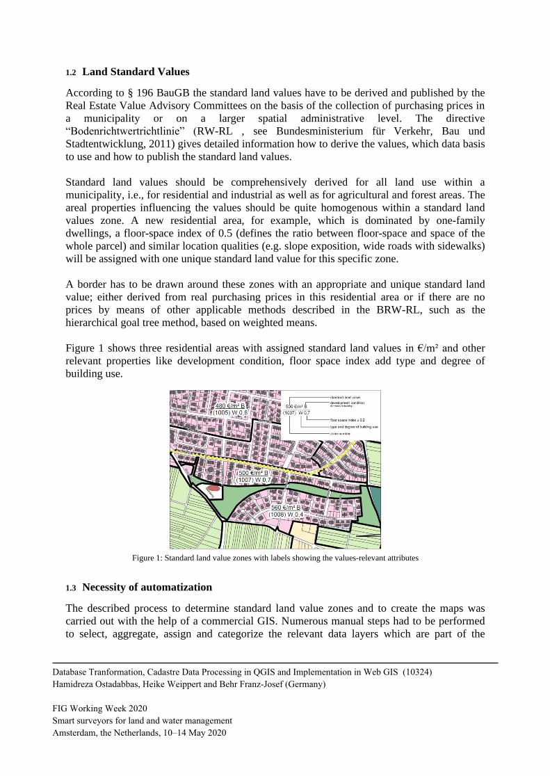
1.2 Land Standard Values
According to § 196 BauGB the standard land values have to be derived and published by the
Real Estate Value Advisory Committees on the basis of the collection of purchasing prices in
a municipality or on a larger spatial administrative level. The directive
“Bodenrichtwertrichtlinie” (RW-RL , see Bundesministerium für Verkehr, Bau und
Stadtentwicklung, 2011) gives detailed information how to derive the values, which data basis
to use and how to publish the standard land values.
Standard land values should be comprehensively derived for all land use within a
municipality, i.e., for residential and industrial as well as for agricultural and forest areas. The
areal properties influencing the values should be quite homogenous within a standard land
values zone. A new residential area, for example, which is dominated by one-family
dwellings, a floor-space index of 0.5 (defines the ratio between floor-space and space of the
whole parcel) and similar location qualities (e.g. slope exposition, wide roads with sidewalks)
will be assigned with one unique standard land value for this specific zone.
A border has to be drawn around these zones with an appropriate and unique standard land
value; either derived from real purchasing prices in this residential area or if there are no
prices by means of other applicable methods described in the BRW-RL, such as the
hierarchical goal tree method, based on weighted means.
Figure 1 shows three residential areas with assigned standard land values in €/m² and other
relevant properties like development condition, floor space index add type and degree of
building use.
Figure 1: Standard land value zones with labels showing the values-relevant attributes
1.3 Necessity of automatization
The described process to determine standard land value zones and to create the maps was
carried out with the help of a commercial GIS. Numerous manual steps had to be performed
to select, aggregate, assign and categorize the relevant data layers which are part of the
Database Tranformation, Cadastre Data Processing in QGIS and Implementation in Web GIS (10324)
Hamidreza Ostadabbas, Heike Weippert and Behr Franz-Josef (Germany)
FIG Working Week 2020
Smart surveyors for land and water management
Amsterdam, the Netherlands, 10–14 May 2020
cadastre land register (ALKIS). As this procedure is vulnerable, time and cost intensive
(licence fees) the need to automize the main functionalities arise. The concept was developed
to migrate the process completely from the proprietary GIS to an Open Source GIS (QGIS),
database (PostgreSQL) and Web GIS (QGIS server and Lizmap as Web client) to be
financially independent and to adapt possibly the tools to specific requirements by
programming individual plugins. The overall goal is a continuous supply geospatial chain (see
Schmitz 2007) encompassing all the steps and integrating all data sources to derive the
desired output according to the law.
2. METHODOLOGY
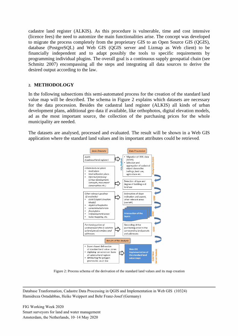
In the following subsections this semi-automated process for the creation of the standard land
value map will be described. The schema in Figure 2 explains which datasets are necessary
for the data procession. Besides the cadastral land register (ALKIS) all kinds of urban
development plans, additional geo data if available, like orthophotos, digital elevation models,
ad as the most important source, the collection of the purchasing prices for the whole
municipality are needed.
The datasets are analysed, processed and evaluated. The result will be shown in a Web GIS
application where the standard land values and its important attributes could be retrieved.
Figure 2: Process schema of the derivation of the standard land values and its map creation
Database Tranformation, Cadastre Data Processing in QGIS and Implementation in Web GIS (10324)
Hamidreza Ostadabbas, Heike Weippert and Behr Franz-Josef (Germany)
FIG Working Week 2020
Smart surveyors for land and water management
Amsterdam, the Netherlands, 10–14 May 2020
2.1 Importing layers into the PostgreSQL database
A first aim is to import the ALKIS data in NAS format to the PostgreSQL database without
using a GIS. NAS, as a complex GML profile, is not easy to import with general GML
drivers. Therefore ALKIS- Import 2.1-24 from norBIT (norBit n.d.) has to be installed using
OSGeo4W, a “binary distribution of a broad set of Open-Source Geospatial software for
Windows environments” (OSGeo4W, 2018). The correct projection and coordinate system
have to be specified.
The ALKIS data consists of more than 200 layers with different geometry types. Hence data
loading even for smaller municipalities up to 10,000 inhabitants takes approximately 9
minutes. However for the determination of standard land values only 25 layers provide
important information and are extracted.
2.2 Layers preparation in the database by means of SQL-coding
Before starting the layer preparation in the PostgreSQL via SQL coding the data layers on
which procession should be taken out have to be defined. One of the important layers is the
land parcel layer containing the polygon geometry and, as attributes, the counter and the
denominator numbers, which combined form the unique identifier of each registered land
parcel within a municipality. The land parcels represent the smallest geometry level. Another
important layer is the address layer including street names and house numbers as well as the
defined angle for labelling.
Additionally a blank layer representing the standard land value zones has to be compiled. The
geometry type is defined as polygon using the PostGIS extension and the attributes have
specified abbreviations and type formats given by the
BRW-RL. The digitization has to be carried out later manually on screen according to the
delineated zones defined by experts in the company.
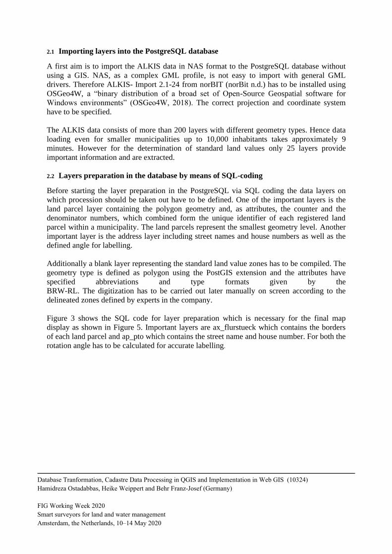
Figure 3 shows the SQL code for layer preparation which is necessary for the final map
display as shown in Figure 5. Important layers are ax_flurstueck which contains the borders
of each land parcel and ap_pto which contains the street name and house number. For both the
rotation angle has to be calculated for accurate labelling.
Database Tranformation, Cadastre Data Processing in QGIS and Implementation in Web GIS (10324)
Hamidreza Ostadabbas, Heike Weippert and Behr Franz-Josef (Germany)
FIG Working Week 2020
Smart surveyors for land and water management
Amsterdam, the Netherlands, 10–14 May 2020
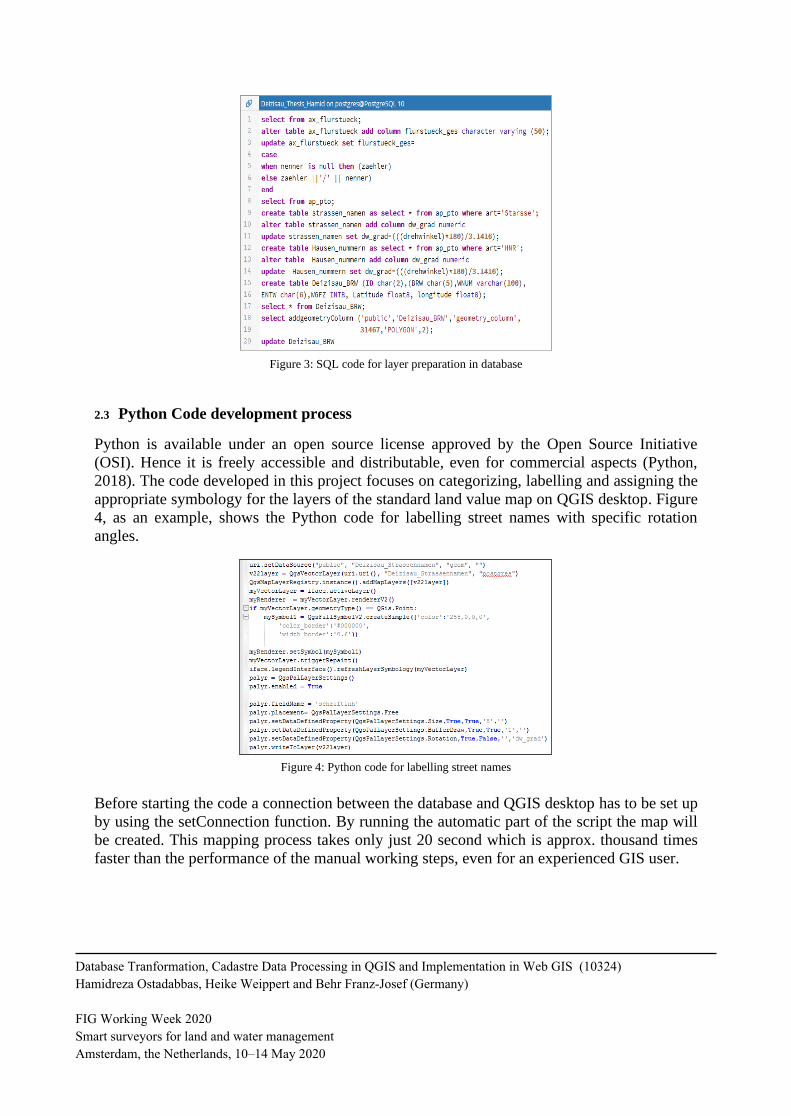
Figure 3: SQL code for layer preparation in database
2.3 Python Code development process
Python is available under an open source license approved by the Open Source Initiative
(OSI). Hence it is freely accessible and distributable, even for commercial aspects (Python,
2018). The code developed in this project focuses on categorizing, labelling and assigning the
appropriate symbology for the layers of the standard land value map on QGIS desktop. Figure
4, as an example, shows the Python code for labelling street names with specific rotation
angles.
Figure 4: Python code for labelling street names
Before starting the code a connection between the database and QGIS desktop has to be set up
by using the setConnection function. By running the automatic part of the script the map will
be created. This mapping process takes only just 20 second which is approx. thousand times
faster than the performance of the manual working steps, even for an experienced GIS user.
Database Tranformation, Cadastre Data Processing in QGIS and Implementation in Web GIS (10324)
Hamidreza Ostadabbas, Heike Weippert and Behr Franz-Josef (Germany)
FIG Working Week 2020
Smart surveyors for land and water management
Amsterdam, the Netherlands, 10–14 May 2020
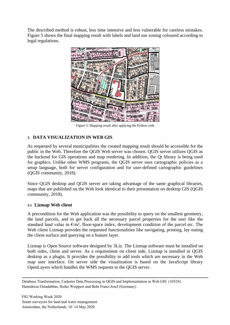
The described method is robust, less time intensive and less vulnerable for careless mistakes.
Figure 5 shows the final mapping result with labels and land use zoning coloured according to
legal regulations.
Figure 5: Mapping result after applying the Python code
3. DATA VISUALIZATION IN WEB GIS
As requested by several municipalities the created mapping result should be accessible for the
public in the Web. Therefore the QGIS Web server was chosen. QGIS server utilizes QGIS as
the backend for GIS operations and map rendering. In addition, the Qt library is being used
for graphics. Unlike other WMS programs, the QGIS server uses cartographic policies as a
setup language, both for server configuration and for user-defined cartographic guidelines
(QGIS community, 2018).
Since QGIS desktop and QGIS server are taking advantage of the same graphical libraries,
maps that are published on the Web look identical to their presentation on desktop GIS (QGIS
community, 2018).
3.1 Lizmap Web client
A precondition for the Web application was the possibility to query on the smallest geometry,
the land parcels, and to get back all the necessary parcel properties for the user like the
standard land value in €/m², floor-space index, development condition of the parcel etc. The
Web client Lizmap provides the requested functionalities like navigating, printing, lay outing
the client surface and querying on a feature layer.
Lizmap is Open Source software designed by 3Liz. The Lizmap software must be installed on
both sides, client and server. As a requirement on client side, Lizmap is installed in QGIS
desktop as a plugin. It provides the possibility to add tools which are necessary in the Web
map user interface. On server side the visualization is based on the JavaScript library
OpenLayers which handles the WMS requests to the QGIS server.
Database Tranformation, Cadastre Data Processing in QGIS and Implementation in Web GIS (10324)
Hamidreza Ostadabbas, Heike Weippert and Behr Franz-Josef (Germany)
FIG Working Week 2020
Smart surveyors for land and water management
Amsterdam, the Netherlands, 10–14 May 2020
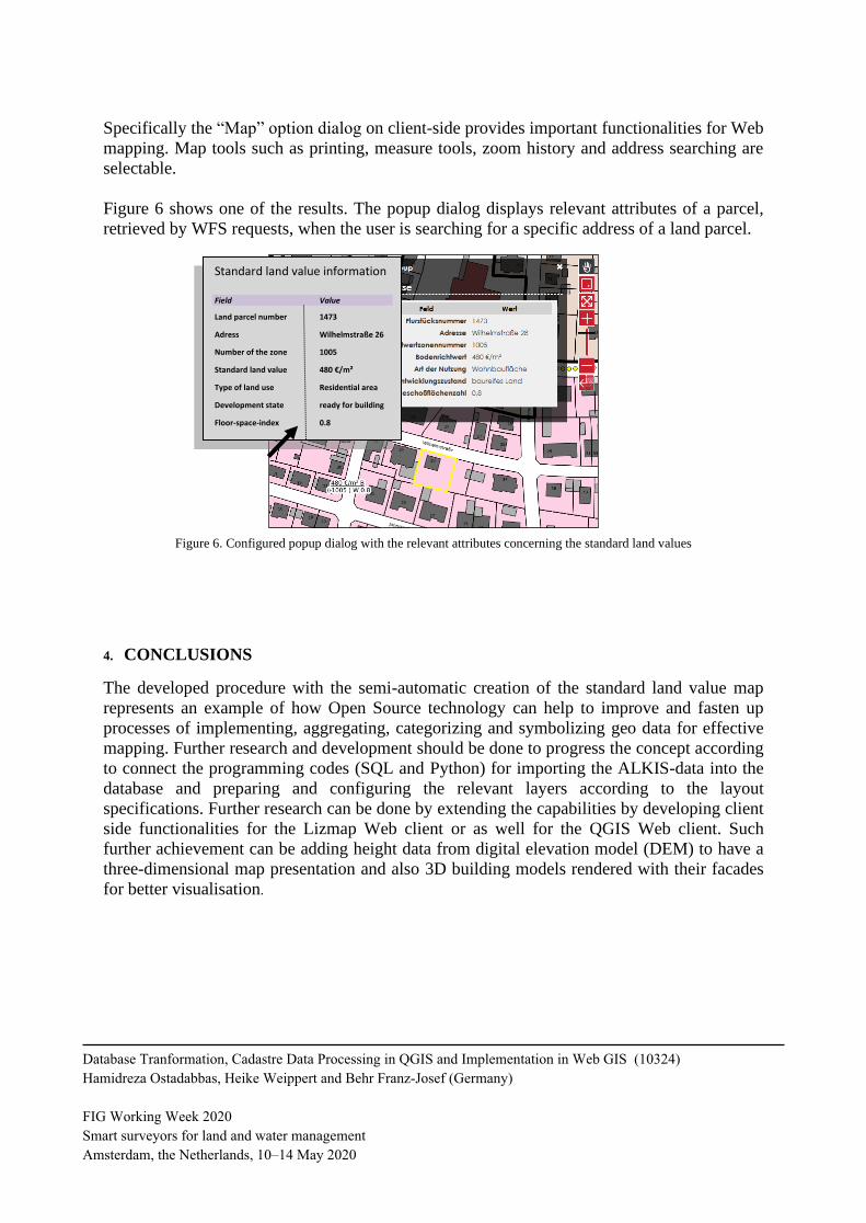
Specifically the “Map” option dialog on client-side provides important functionalities for Web
mapping. Map tools such as printing, measure tools, zoom history and address searching are
selectable.
Figure 6 shows one of the results. The popup dialog displays relevant attributes of a parcel,
retrieved by WFS requests, when the user is searching for a specific address of a land parcel.
Figure 6. Configured popup dialog with the relevant attributes concerning the standard land values
4. CONCLUSIONS
The developed procedure with the semi-automatic creation of the standard land value map
represents an example of how Open Source technology can help to improve and fasten up
processes of implementing, aggregating, categorizing and symbolizing geo data for effective
mapping. Further research and development should be done to progress the concept according
to connect the programming codes (SQL and Python) for importing the ALKIS-data into the
database and preparing and configuring the relevant layers according to the layout
specifications. Further research can be done by extending the capabilities by developing client
side functionalities for the Lizmap Web client or as well for the QGIS Web client. Such
further achievement can be adding height data from digital elevation model (DEM) to have a
three-dimensional map presentation and also 3D building models rendered with their facades
for better visualisation.
Standard land value information Field Value
Land parcel number 1473
Adress Wilhelmstraße 26
Number of the zone 1005
Standard land value 480 €/m²
Type of land use Residential area
Development state ready for building
Floor-space-index 0.8
Database Tranformation, Cadastre Data Processing in QGIS and Implementation in Web GIS (10324)
Hamidreza Ostadabbas, Heike Weippert and Behr Franz-Josef (Germany)
FIG Working Week 2020
Smart surveyors for land and water management
Amsterdam, the Netherlands, 10–14 May 2020
REFERENCES
AdV, 2008. Modellierung der Geoinformationen des amtlichen Vermessungswesens –
GeoInfoDok, Version 6.0. http://www.adv-online.de/AAA-Modell/Dokumente-der-
GeoInfoDok/broker.jsp?uMen=4ad505ea-127b-b941-2df2-65a572e13d63 (01 June 2019).
BauGB, 2017. Baugesetzbuch in der Fassung der Bekanntmachung vom 3. November 2017
(BGBl. I S. 3634). https://www.gesetze-im-internet.de/bbaug/ (01 June 2019).
Bundesministerium für Verkehr, Bau und Stadtentwicklung, 2011. Richtlinie zur Ermittlung
von Bodenrichtwerten (Bodenrichtwertrichtlinie, (Bodenrichtwertrichtlinie – BRW-RL).
https://www.bundesanzeiger-verlag.de/fileadmin/BIV-Portal/Bildervorschlaege/PDF/-
Bodenrichtwertrichtlinie.pdf (01 June 2019).
Gutachterausschuss für Grundstückswerte in der Stadt Hagen (Eds.): 50 Jahre 1961-2011.
http://www.gutachterausschuss.hagen.de/web/media/files/Broschuere_50_-
Jahre_Gutachter.pdf (04 June 2019)
Höhn, R., Schaar, W., 2011. 50 Gutachterausschuss für Grundstückswerte in Deutschland uns
speziell in Nordrhein-Westfalen. In: Gutachterausschuss für Grundstückswerte in der Stadt
Hagen (Eds.): 50 Jahre 1961-2011:7-34.
ImmoWertV, 2010. Verordnung über die Grundsätze für die Ermittlung der Verkehrswerte
von Grundstücken. https://www.gesetze-im-internet.de/immowertv/ (01 June 2019)
norBit, n.d.: norGIS-ALKIS-Import. http://www.norbit.de/68/ (03 June 2019)
OSGeo4W, 2018. FOSSGIS for Windows. https://¬trac.osgeo.org/¬osgeo4w/ (14 October
2018).
Python, 2018. About Python. https://www.python.org/about/ (16 November 2018).
QGIS community, 2018. QGIS as OGC Data Server.
https://docs.qgis.org/2.14/en/docs/user_manual/working_with_ogc/ogc_server_support.html
(28 November 2018).
Schmitz, PMU. 2007: The use of supply chains and supply chain management to improve the
efficiency and effectiveness of GIS units’. Unpublished PhD thesis, University of
Johannesburg, Johannesburg, South Africa.
Seifert, M., 2005. Das AFIS-ALKIS-ATKIS-Anwendungsschema als Komponente einer
Geodateninfrastruktur. Zeitschrift für Geodäsie, Geoinformation und Landmanagement (zfv)
130:77–81.
Database Tranformation, Cadastre Data Processing in QGIS and Implementation in Web GIS (10324)
Hamidreza Ostadabbas, Heike Weippert and Behr Franz-Josef (Germany)
FIG Working Week 2020
Smart surveyors for land and water management
Amsterdam, the Netherlands, 10–14 May 2020
CONTACT
Contact person: Hamidreza Ostadabbas
Institution: Dr. Koch GmbH
Address: Dr. Koch Immobilienbewertung GmbH, 73730 Esslingen am Neckar, Germany
E-Mail: [email protected]
Website address: https://www.dr-koch-immo.de/unternehmen/team/hamidreza-ostadabbas/
Database Tranformation, Cadastre Data Processing in QGIS and Implementation in Web GIS (10324)
Hamidreza Ostadabbas, Heike Weippert and Behr Franz-Josef (Germany)
FIG Working Week 2020
Smart surveyors for land and water management
Amsterdam, the Netherlands, 10–14 May 2020
Recommended