Canadian Hazards Information Service (CHIS) and
Seismic Networks in Canada
Tim Côté
Canadian Hazards Information Service Natural Resources Canada (NRCan)
Antelope Users Group meeting Reno, Nevada
October 23-25, 2012

2
What We Are Part Of § Natural Resources Canada (NRCan) – federal government
§ Earth Sciences Sector § Geological Survey of Canada (GSC-AWCB)
§ Canadian Hazards Information Service (CHIS) § Earthquakes Canada
§ What is CHIS involved in? – Natural Hazards § Earthquake Monitoring – Earthquakes Canada § Geomagnetic Monitoring § Space Weather Forecasting § Nuclear Emergency Response
§ Providing real-time mapping of radiation release
§ Tsunamis and Landslides § Nuclear Explosion Monitoring
§ Other groups in NRCan but outside CHIS that do more research § CHIS focus: operating the seismic network, locating eq’s, eq catalog

3
Earthquakes in or near Canada
4
Mandate
§ Canadian Hazards Information Service Mandate § “the provision of information on the actual or probable
occurrence and intensity of earthquakes”.
§ From the Emergency Management Act § Clients:
§ Federal, provincial, and territorial Emergency Management Organizations (EMOs)
§ Critical Infrastructure (CI) operators § Media § Canadian public

5
CHIS Seismology Staff and Budgets
§ 4 offices (Ottawa, East Ottawa, Sidney, Yellowknife) § 3 seismologists + 1 contractor
§ Recently lost 1 seismologist and 1 contractor
§ 5 Scientists (plus other researchers for on-call work) § 6 IT specialists plus Acting IT manager § 11 Field technicians plus Acting Field Operations manager
§ ~$500k per year plus one time “capital” requests § Lost $750k per year plus 2 IT staff to Shared Services
Canada (consolidate IT data centres & communications) § Salary costs not included

6
CHIS Earthquake Responsibilities
§ Seismic Monitoring § Collaboration with other agencies – data exchange § Rapid Response for Earthquake Info § Public Information § Earthquake Hazard Assessment
§ Seismic hazard zoning maps § National Building Code
§ Advice for Critical Infrastructure § Hydro dams, Nuclear power plants § Pipelines, power transmission lines, etc.

7
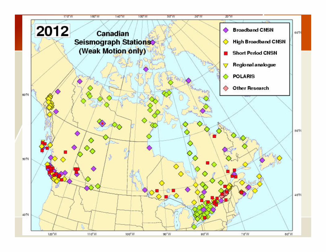
Seismic Monitoring - Inputs
§ Continuous, real-time, weak-motion data from: § Canadian National Seismograph Network (CNSN)
§ ~160 Observatory-grade, permanent stations § Refresh network in coming years
§ Other special deployments within NRCan § ~60 temporary stations, e.g. ETS, PISA, SL
§ University stations from POLARIS Network § ~55 Portable, temporary stations for research
§ Strong motion monitoring § ~120+ stations in Canada
8

9
10
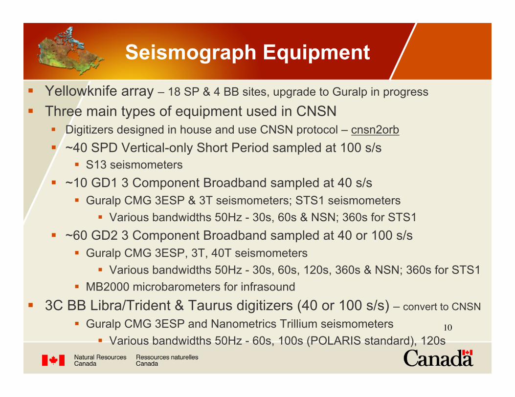
Seismograph Equipment
§ Yellowknife array – 18 SP & 4 BB sites, upgrade to Guralp in progress
§ Three main types of equipment used in CNSN § Digitizers designed in house and use CNSN protocol – cnsn2orb § ~40 SPD Vertical-only Short Period sampled at 100 s/s
§ S13 seismometers § ~10 GD1 3 Component Broadband sampled at 40 s/s
§ Guralp CMG 3ESP & 3T seismometers; STS1 seismometers § Various bandwidths 50Hz - 30s, 60s & NSN; 360s for STS1
§ ~60 GD2 3 Component Broadband sampled at 40 or 100 s/s § Guralp CMG 3ESP, 3T, 40T seismometers
§ Various bandwidths 50Hz - 30s, 60s, 120s, 360s & NSN; 360s for STS1 § MB2000 microbarometers for infrasound
§ 3C BB Libra/Trident & Taurus digitizers (40 or 100 s/s) – convert to CNSN
§ Guralp CMG 3ESP and Nanometrics Trillium seismometers § Various bandwidths 50Hz - 60s, 100s (POLARIS standard), 120s

11
NCRB & WOSB in British Columbia

12
ULM Seismic Station in Manitoba

13
Polaris KSVO Station

14
Other Deployments
June 23, 2010 Val-des-Bois Aftershock deployment
Feb 2010 Haiti Deployment
Val-des-Bois real-time station, installed July
24, 2010

15
Strong Motion Monitoring
• ~100 Internet Accelerometers
• ia2orb for data access • Some Nanometrics Titan
• At Libra or Taurus weak-motion sites
• ~20 Kinemetrics Altus Etna • Non-realtime
• Future – increase in strong motion stations • collocated with weak
motion stations

16
Seismic Monitoring - Telecommunications Network
§ Acquisition of continuous, real-time CNSN data requires operation of a national telecommunications network (SeisWAN) involving 30+ VSAT satellite links, UHF/VHF radio, spread-spectrum radio, dedicated telephone/modem links, cell modems, T1 links, Frame Relay links, and the Internet.
§ Heterogeneous on purpose!
§ ~60 Nanometrics Libra stations in CNSN and POLARIS use Carina Hub for master earth station and NAQS software which is then converted to CNSN protocol. Will replace NAQS with ApolloServer & SeedLink feed.

17
Seismic Monitoring - CHIS Data Centres
Two data centres: Ottawa, Sidney § Parallel Operation § Redundant Systems & Communications § Change control procedures
§ 2 man rule, in-house ticket tracking system § Operate on a 24x7 basis with on-call IT systems staff
§ Legacy systems – Sparc/Solaris with in-house software § New systems – Intel/Linux CentOS with Antelope & Nanometrics software
§ Acquire, process and archive over 4 GB/day of waveform data
§ Waveform Archive (~20 TB and growing) – sync’d between data centres § Channel or station day files, internal or mini-seed format
§ National Earthquake DataBase (catalogue), Ingres RDBMS moving to Postgres § Automatic and analyst reviewed processes to locate earthquakes

18
Collaboration with Other Agencies – Data Exchange
§ Forward real-time data from 10 IMS stations to CTBTO in Vienna (under contract with SLA’s)
§ Disseminate Wave Form and Earthquake data to other agencies and researchers including: § Tsunami Warning Centres § USGS § IRIS § US Regional Networks
§ Import and export via various formats § CD1.x, orb2orb, earthworm, seedlink, NMXP/
NP, etc
§ Earthquake Catalogue § Sent to ISC when complete § Bulletins from US networks
imported via Antelope § Working towards better
real-time integration with USGS

19
Rapid Response for Earthquake Info and Public Information
§ 24x7 on-call seismologists provide rapid information on earthquake location, magnitude, aftershocks
§ Earthquake reports, maps & lists @ www.earthquakescanda.ca, DYFI § Tweet automatic and reviewed earthquake notifications on Twitter
§ English: @CANADAquakes, Français: @CANADAseisme § AENEAS (Automated Event Notification and Eq Alert Service)
§ Alerts Customized for client’s facilities and thresholds § sent via email, scp, SMS, ftp, fax
§ e.g. “STOP/SLOW TRAIN” alerts sent to railways within minutes § Earthquake alerts to Multi-Agency Situational Awareness System
(MASAS) using open standards, e.g. Common Alerting Protocol (CAP) § sharing of location-based situational awareness information and alerts
between issuers, first responders & emergency management agencies

20
Processing System
§ Legacy Data Processing System – developed in-house
§ New Antelope 5.2 System – partially implemented
acquisition autoloc alert detection
archive review database publish
import
export
hub Automatic processing
review Antelopewf archive
acquisition
Permanent archive DMZ
§ Orb for waveform § Separate Orb for other
data (e.g. parametric) § Dbmaster on select zones
National Earthquake
database
alert
§ Current Sidney Antelope 4.x System – all on one computer
publish

21
Challenges & Future Issues
§ Validating station response that is created with dbbuild. § Currently create dbmaster from Ingres reference database
§ Configure dbloc2, dbpick and location programs to work for Ottawa office.
§ Configure all desired magnitudes (e.g. Mn) with dbevproc § save amplitude and period info. § view and manipulate automatic amplitude and period “picks” for magnitude.
§ Handle felt flag, blast flag and event comments. § Transfer of events (or entire catalogue) to and from existing Ingres
reference database § Configure orbassoc for automatic locations of events in Canada § Move non-Antelope tasks (e.g. alerting) into Antelope § Add shakemap product § Handle future seismograph network upgrades
Recommended


![Radio frequency hazards - Amazon S3...IATG 05.60:2015[E] 2nd Edition (2015-02-01) 1 Radio frequency hazards 1 Scope This IATG introduces potential radio frequency (RF) hazards. It](https://img.pdfslide.us/doc/110x75/5f09621c7e708231d4269327/radio-frequency-hazards-amazon-s3-iatg-05602015e-2nd-edition-2015-02-01.jpg)