ERM 09/11
Project No.Date:Drawn By:GIS File: 012045009/06/11T. Cota
6200
6150
6100
6250
6000
6050
5900
5850
5950
6350
6300
6400
6450
6500
6160
6120
5800
6550
62406280
5750
5650
5700
6080
6040
5600
6290
6600
5960
6190
6180
5940
5550
6170
5920
6320
5880
6270
6230
6650
5760
6110
6540
6310
6340
6360
6052
5720
5970
6010
5840
6060
6290
5950
6050
6050
5950
6120
6160
6300
6350
6250
6400
6240
6250
6300
6250
5900
6300
5750
6300
6300
6250
6280
6350
6250
6160
6280
6000
6300
6200
6150
6300
6300
6300
5650
6270
6450
6100
6280
5800
5950
6300
5700
6200
5800
6250
6500
6000
6300
6290
6200
6250
6250
6150
6250
5750
6550
61006000
6400
6450
6350
6200
5700
6300
5600
6000
6200
5800
6500
6000
6450
6270
5850
6300
5950
6300
6280
6250
6300
6350
5950
6200
6240
6150
6320
6350
6160
61206100 6350
6200
6230
605061
80
6180
6300
5800
6250
6300 6300
6300
6100
6250
6350
5750
6050
5900
6400
6350
6250
0 800 1,600400
Feet
p
LEGENDAmerican Eagle/Deep Portland PitRoadsStreamsJuno_Foley_POPMining Permit Boundary
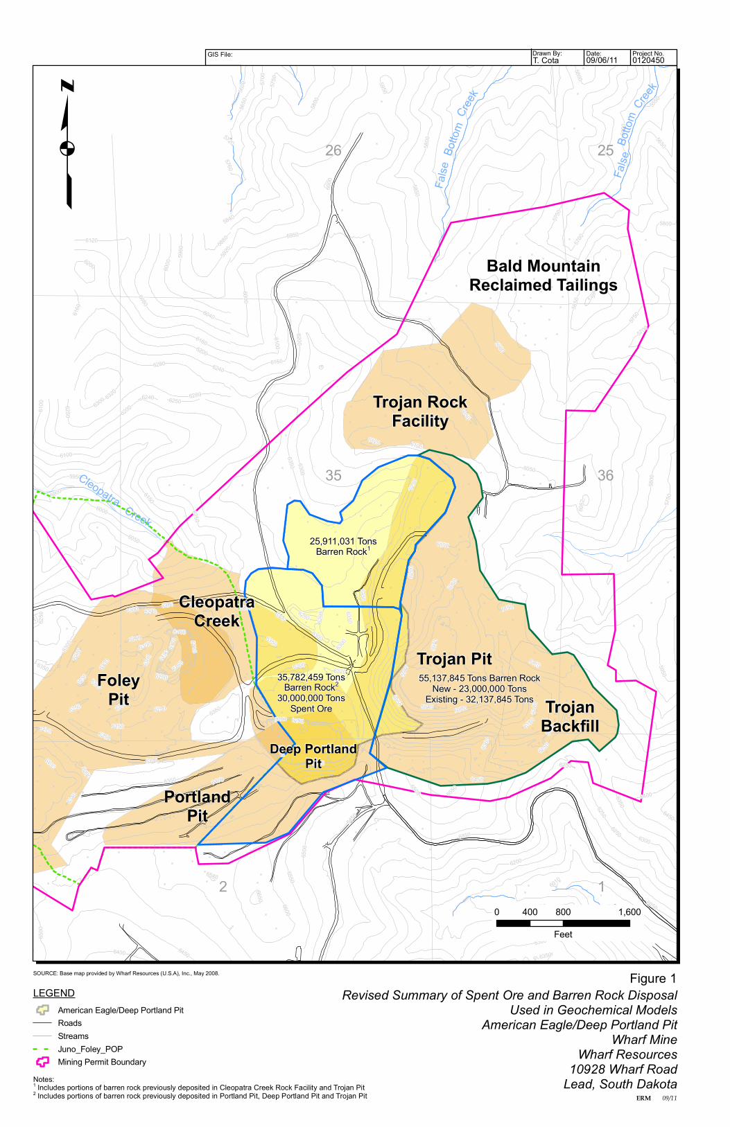
Revised Summary of Spent Ore and Barren Rock DisposalUsed in Geochemical Models
American Eagle/Deep Portland PitWharf Mine
Wharf Resources10928 Wharf Road
Lead, South Dakota
Figure 1SOURCE: Base map provided by Wharf Resources (U.S.A), Inc., May 2008.
36
25
35
26
False
Botto
mCree
k
False
Botto
mCre
ek
Trojan RockFacility
Bald MountainReclaimed Tailings
Trojan Pit
CleopatraCreek
FoleyPit
Cleopatra
PortlandPit
Notes:1 Includes portions of barren rock previously deposited in Cleopatra Creek Rock Facility and Trojan Pit2 Includes portions of barren rock previously deposited in Portland Pit, Deep Portland Pit and Trojan Pit
TrojanBackfill
2 1
Deep PortlandPit
Creek25,911,031 Tons
Barren Rock1
35,782,459 TonsBarren Rock2
30,000,000 TonsSpent Ore
55,137,845 Tons Barren RockNew - 23,000,000 Tons
Existing - 32,137,845 Tons
ERM 09/11
Project No.Date:Drawn By:GIS File: 012045009/06/11T. Cota
!>!>
!>
!>
!>!>
@A
@A
@A
@A@A
@A
@A
@A@A
@A@A
@A
@A
@A
MW-64MW-63MW-62MW-61
MW-60
MW-59
MW-43MW-42
MW-41
MW-40MW-37
Joseph Well
Horse Shoe MW
2
4
6
810
1214
1618
18
6
12
812
144
2
84
14
10
10
4
1416
FB-2FB-1
War Eagle
False Bottom Spring
Compliance Point 007
Compliance Point 004
5950
6200
6250
61506100
6050
6000
5850
5900
6300
6350 6400
6450
5800
5750
5700
56505600
5550
6160
6120
62406280
6500
5500
6080
6550
6040
5450
6290
6600
5960
6190
6180
59406170
5920
63205640
5880
6270
6230
6650
57605560
6110
6540
6340
6360
6052
6380
5720
5520
5970
6010
6060
5450
5750
5800
5900
6250
6300
6500
6300
6250
6350
6250
6300
6320
6240
6230
6250
6300
6150
6250
6300
6250
6450
6270
6300
6000
5550
6320
6300
5850
6250
5850
6300
5750
6000
6450
6200
6050
6550
6350
5750
5900
6050
6200
6000
5850
6300
6350
6350
6350
6280
5950
6100
6300
6050
5650
6450
6300
6000
6500
6240
5800
6250
6120
5800
6200
62406280
5950
5950
6160
6280
6240
6160
6200
5700
6250
6350
6180
6300
6200
58006550
5700
5800
6290
6250
6180
6300
5900
6050
5550
6300
6300
6400
5850
6400
5600
5650
6600
6200
5750
5700
6500
6000
6550
6150
6290
6100
6300
5700
6250
6250
6300
6300
5500
0 900 1,800450
Feet
p
LEGENDNitrate Concentration (mg/L) - Year 2040Spent Ore Disposal AreaAmerican Eagle/Deep Portland Pit
@A Monitoring Well!> Surface Water Monitoring Station
RoadsStreamsWharf Land OwnershipMining Permit Boundary
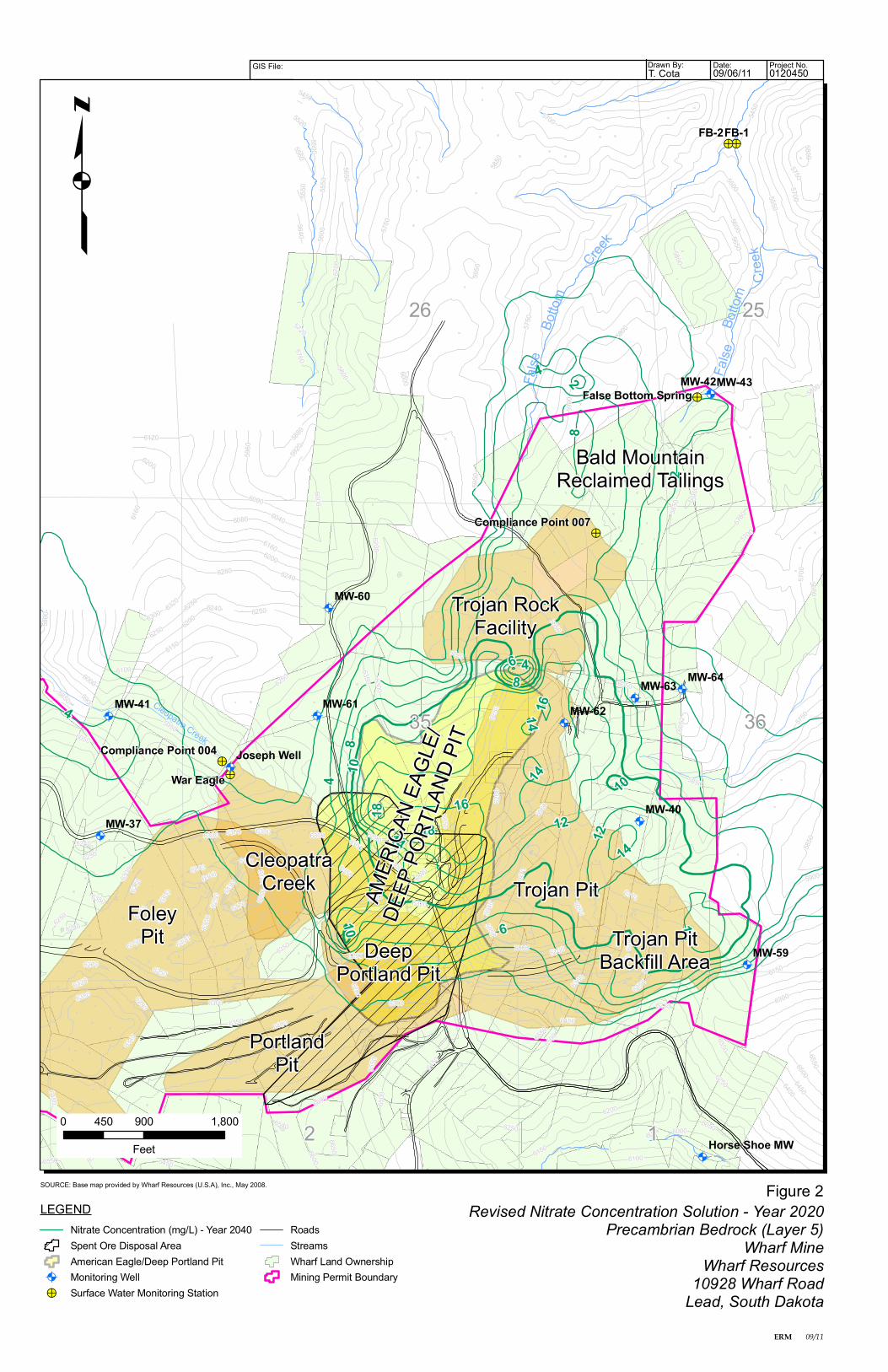
Revised Nitrate Concentration Solution - Year 2020Precambrian Bedrock (Layer 5)
Wharf MineWharf Resources
10928 Wharf RoadLead, South Dakota
Figure 2SOURCE: Base map provided by Wharf Resources (U.S.A), Inc., May 2008.
35
26 25
False
Botto
mCr
eek
False
Botto
mCree
kTrojan Rock
Facility
Bald MountainReclaimed Tailings
DeepPortland Pit
CleopatraCreek
FoleyPit
Cleopatra Creek
PortlandPit
Trojan PitBackfill Area
Trojan Pit
36
12
AMER
ICAN E
AGLE
/DE
EP PO
RTLA
ND PI
T
ERM 09/11
Project No.Date:Drawn By:GIS File: 012045009/06/11T. Cota
!>!>
!>
!>
!>!>
@A
@A
@A
@A@A
@A
@A
@A@A
@A@A
@A
@A
@A
MW-64MW-63MW-62MW-61
MW-60
MW-59
MW-43MW-42
MW-41
MW-40MW-37
Joseph Well
Horse Shoe MW
2 4
6
8
10
12
1416
18
18
4
4 2
4
412
16
8
8
8
4
12
4
6
10
88
12
FB-2FB-1
War Eagle
False Bottom Spring
Compliance Point 007
Compliance Point 004
5950
6200
6250
61506100
6050
6000
5850
5900
6300
6350 6400
6450
5800
5750
5700
56505600
5550
6160
6120
62406280
6500
5500
6080
6550
6040
5450
6290
6600
5960
6190
6180
59406170
5920
63205640
5880
6270
6230
6650
57605560
6110
6540
6310
6340
6360
6052
6380
5720
5520
5970
6010
6060
6300
6350
5750
6100
6300
6150
5550
6250
6050
6050
6250
6280
6000
6300
6230
6150
6000
5800
6100
5800
6250
6400
6200
6250
6350
6550
6300
5800
6300
6550
6450
6500
5550
6350
6300
6300
62806300
6500
6050
6300
6240
6000
6250
6250
6250
6200
6300
6500
6200
5900
6300
6250
6350
5600
6280
6300
5850
6290
5700
6160
5800
6450
6250
6100
5850
6350
6120
5500
6300
6160
5850
6250
6250
5950
6280
6300
6240
5750
5950
5700
6180
59006000
5800
6320
5450
6550
6200
5750
6250
6450
6600
6400
6320
6300
5850
6300
6300
6300
6350
6000
5650
5950
5650
6180
6200
5750
5700
6050
6250
6290
6150
5900
5700
6200
0 900 1,800450
Feet
p
LEGENDNitrate Concentration (mg/L) - Year 2040Spent Ore Disposal AreaAmerican Eagle/Deep Portland Pit
@A Monitoring Well!> Surface Water Monitoring Station
RoadsStreamsWharf Land OwnershipMining Permit Boundary
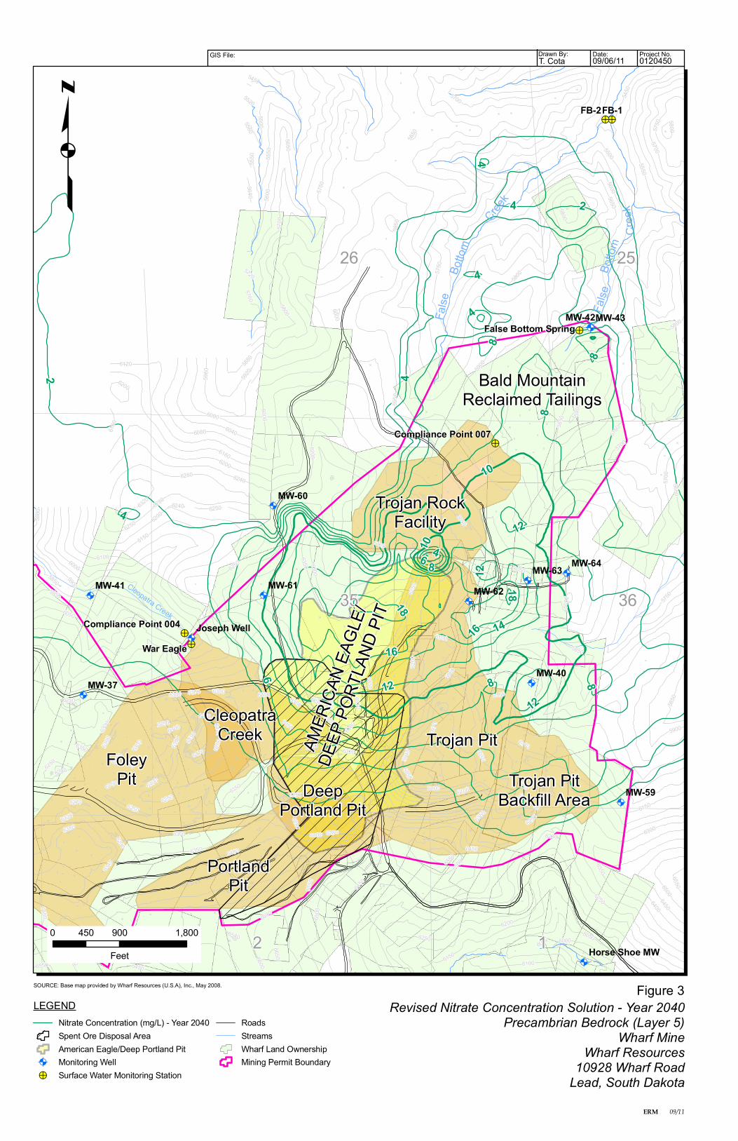
Revised Nitrate Concentration Solution - Year 2040Precambrian Bedrock (Layer 5)
Wharf MineWharf Resources
10928 Wharf RoadLead, South Dakota
Figure 3SOURCE: Base map provided by Wharf Resources (U.S.A), Inc., May 2008.
35
26 25
False
Botto
mCr
eek
False
Botto
mCree
kTrojan Rock
Facility
Bald MountainReclaimed Tailings
DeepPortland Pit
CleopatraCreek
FoleyPit
Cleopatra Creek
PortlandPit
Trojan PitBackfill Area
Trojan Pit
36
12
AMER
ICAN E
AGLE
/DE
EP PO
RTLA
ND PI
T

ERM 09/11
Project No.Date:Drawn By:GIS File: 012045009/06/11T. Cota
!>!>
!>
!>
!>!>
@A
@A
@A
@A@A
@A
@A
@A@A
@A@A
@A
@A
@A
MW-64MW-63MW-62MW-61
MW-60
MW-59
MW-43MW-42
MW-41
MW-40MW-37
Joseph Well
Horse Shoe MW
2
4
6
8
10
12
8
2
2
8
2
4
4
4
2
4
10
6
8
2
6
6
8
8
84
8
4
6
6
2
68
2
4
6
4
6
82
8
8
FB-2FB-1
War Eagle
False Bottom Spring
Compliance Point 007
Compliance Point 004
5950
6200
6250
61506100
6050
6000
5850
5900
6300
6350 6400
6450
5800
5750
5700
56505600
5550
6160
6120
62406280
6500
5500
6080
6550
6040
5450
6290
6600
5960
6190
6180
59406170
5920
63205640
5880
6270
6230
6650
57605560
6110
6540
6310
6340
6360
6052
6380
5720
5520
5970
6010
6060
5450
6300
6300
6250
6320
5700
5750
6230
6050
6280
5850
6250
6250
6050
5750
6350
6250
5700
6250
6050
6300
6250
6100
6240
6160
6300
6300
6300
6200
6300
5600
6300
6550
6290
6600
6200
6350
6450
5950
6290
6150
6400
6300
6200
6250
5950
6200
6300
6250
6500
6280
5800
6320
6300
6350
6000
6200
6450
6250
6120
6200
6240
5700
6150
6300
6250
6000
5900
6100
5850
6000
6350
6250
5950
6300
6000
5750
6350
6250
5600
6160
61006450
6300
5800
5900
5550
5650
5800
5800
6150
5750
6280
6550
6500
6400
6180
6300
5500
6550
5800
6350
6180
5900
6050
6300
5850
5850
5650
6300
6000
6300
6500
5700
6250
6300
0 900 1,800450
Feet
p
LEGENDNitrate Concentration (mg/L) - Year 2040Spent Ore Disposal AreaAmerican Eagle/Deep Portland Pit
@A Monitoring Well!> Surface Water Monitoring Station
RoadsStreamsWharf Land OwnershipMining Permit Boundary
Revised Nitrate Concentration Solution - Year 2060Precambrian Bedrock (Layer 5)
Wharf MineWharf Resources
10928 Wharf RoadLead, South Dakota
Figure 4SOURCE: Base map provided by Wharf Resources (U.S.A), Inc., May 2008.
35
26 25
False
Botto
mCr
eek
False
Botto
mCree
kTrojan Rock
Facility
Bald MountainReclaimed Tailings
DeepPortland Pit
CleopatraCreek
FoleyPit
Cleopatra Creek
PortlandPit
Trojan PitBackfill Area
Trojan Pit
36
12
AMER
ICAN E
AGLE
/DE
EP PO
RTLA
ND PI
T
Recommended