Embed Size (px)
Citation preview
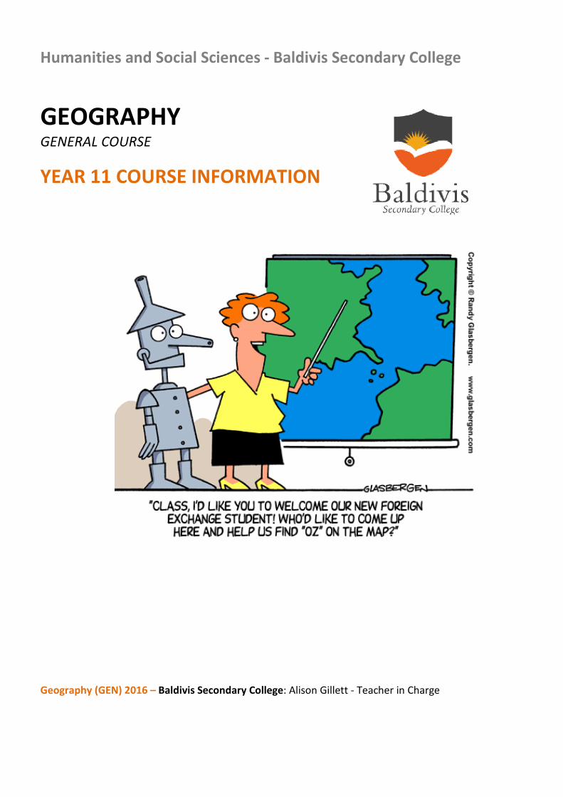
Humanities and Social Sciences - Baldivis Secondary College
GEOGRAPHY GENERAL COURSE
YEAR 11 COURSE INFORMATION
Geography (GEN) 2016 – Baldivis Secondary College: Alison Gillett - Teacher in Charge
CONTENT Structure of Syllabus Page 3 Unit 1 – Geography of Environments at Risk Page 4 - 8 Unit 2 – Geography of People and Places Page 9 - 13 School Based Assessment Page 14 Grade Descriptions Page 15 - 16 Assessment Outline – UNIT 1 and UNIT 2 Page 17 Assessment Outline – UNIT 1 Semester 1 Page 18 Assessment Outline – UNIT 2 Semester 2 Page 19 Course Outline Page 20 - 23
ADDITIONAL INFORMATION: For full course information including:
• Rationale • Aims • Organisation:
o Structure of syllabus o Organisation of content o Progression from the Year 7 – 10 Curriculum o Representation of the general capabilities o Representation of the cross-curriculum priorities
Please refer to: http://wace1516.scsa.wa.edu.au/syllabus-and-support-materials/humanities-and-social-sciences/geography
STRUCTURE OF SYLLABUS
This course is organised into a Year 11 syllabus and a Year 12 syllabus. The cognitive complexity of the syllabus content increases from Year 11 to Year 12.
Structure of the syllabus The Year 11 syllabus is divided into two units, each of one semester duration, which are typically delivered as a pair. The notional time for each unit is 55 class contact hours.
Unit 1 – Geography of environments at risk This unit explores the spatial patterns and processes related to environments at risk, and to the protection of such environments through management at local, regional and global levels.
Unit 2 – Geography of people and places This unit explores the natural and cultural characteristics of a region and the processes that have enabled it to change over time and the challenges it may face in the future.
Each unit includes:
• A unit description – a short description of the focus of the unit
• Unit content – the content to be taught and learned.
The content in each unit is divided into an overview and one or more depth studies.
The content descriptions associated with the overview are designed to be taught at a broad level and in a short timeframe.
The content descriptions associated with the depth study are designed to be taught in a more focused and detailed way, and therefore to take more time to teach.
UNIT 1 – Geography of Environments at Risk
Unit description This unit explores the spatial patterns and processes related to environments at risk, and to the protection of such environments through management at local, regional and global levels. In the local area, in specific regions and globally, people pose threats to the environment as they attempt to meet their needs. Individuals and/or groups can have conflicting viewpoints about particular environments. This can place environments at risk. Sustainable solutions need to be developed for these environments.
Students develop the knowledge, understandings and skills in this unit that are relevant to the world in which they live and which are also appropriate to careers in the environmental protection/rehabilitation, urban and regional development, and tourism industries.
Unit Content This unit includes the knowledge, understandings and skills described below.
Geographical Knowledge and Understanding Overview of environments at risk
• The concepts of environment, biome and ecosystem
• Biotic and abiotic elements of environments, biomes and ecosystems
• The following ecosystem concepts: Biodiversity Food chains and webs Biomass Trophic levels Pyramid of numbers Pyramid of energy Flows of matter and energy
• The differences between natural and cultural features of environments
• The concept of sustainability
Students complete a depth study which is taught with the required geographical inquiry skills and additional geographical skills described in this unit.
Depth Study One
Students investigate at least one of the following environments at risk (this list is not exhaustive).
• Catchments, such as, Swan River, Nile River
• Coasts, such as, Penguin Island and Point Peron, Californian coast
• Coral reefs, such as, Ningaloo, Great Barrier
• World biomes, such as, rainforest, temperate forests, sclerophyllous forest
• Wetlands, for example, Lake Monger
• Glacial environments, for example, Fox Glacier, Antarctica
• National Parks, for example, Purnululu
Students explore the following aspects of the selected environment, biome or ecosystem:
• Biotic and abiotic elements of the selected environment, biome or ecosystem
• Location and distribution of the environment, biome or ecosystem
• Characteristics of the following elements of the environment, biome or ecosystem: Climate, including temperature and rainfall Soils and landforms, including soil structure and topography Flora and fauna, including dominant species and community structures
• The interactions between the flora and fauna of the environment, biome or ecosystem, including the following ecosystem concepts: Biodiversity Food chains and webs Biomass Trophic levels Pyramid of numbers Pyramid of energy Flows of matter and energy
• Interrelationships between biotic elements and abiotic elements of the environment, biome or ecosystem, such as xerophytic adaptations of plants to drought conditions
• Human activity and land use impacts upon patterns and processes within the environment, biome or ecosystem
• Cultural landscapes associated with the environment, biome or ecosystem
• Economic, political and social factors that impact upon decisions about sustainability of the environment, biome or ecosystem
• The different values and viewpoints (environmental, economic and social) that shape the human use of the environment, biome or ecosystem
• Benefits of implementing sustainable practices within the environment, biome or ecosystem
• The extent to which current land use practices are sustainable within the environment, biome or ecosystem
• Measures by which humans are caring for the environment, biome or ecosystem; and the extent to which these measures have been successful.
At Baldivis Secondary College students will study the coastline of Cape Peron as an environment at risk.
Geographical Inquiry and Skills
All the following skills should be taught during this unit. Relevant skills will be emphasised for each depth study.
Geographical inquiry skills
Observing, questioning and planning
• Formulate geographical inquiry questions
• Plan a geographical inquiry with clearly defined aims and appropriate methodology
Collecting, recording, evaluating and representing
• Collect geographical information, incorporating ethical protocols, from a range of primary sources (interviews, questionnaires, student’s own experiences, and field observations) and secondary sources (online maps, websites, spatial software applications, print resources and visual media)
• Record observations in a range of graphic representations using spatial technologies and information and communication technologies
• Evaluate the reliability, validity and usefulness of geographical sources and information
• Acknowledge sources of information and use an approved referencing technique
Interpreting, analysing and concluding
• Analyse geographical information and data from a range of primary and secondary sources, and a variety of perspectives, to draw reasoned conclusions and make generalisations
• Identify and analyse relationships, spatial patterns and trends, and make predictions and inferences
Communicating
• Communicate geographical information, ideas, issues and arguments using appropriate written and/or oral, cartographic, multimodal and graphic forms
• Use geographical language in appropriate contexts to demonstrate geographical knowledge and understanding
Reflecting and responding
• Apply generalisations to evaluate alternative responses to geographical issues at a variety of scales
• Propose individual and collective action, taking into account environmental, social and economic factors, and predict the outcomes of the proposed action
Geographical skills The following geographical skills should be taught within the specified content of each unit.
Mapping skills (use of maps and atlases)
• Identify and interpret a variety of topographic maps, thematic maps (physical, political, and social maps, overlay maps, synoptic charts and climate maps) and statistical maps (proportional circle and dot distribution maps) at different scales (local, national and global)
• Understand and interpret marginal information represented on maps (title, conventional signs contained in the legend, north point, numerical and linear scales)
• Establish position on a map using alphanumeric grid coordinates, eastings and northings, four figure area references, six figure grid references, and latitude and longitude expressed in degrees and minutes
• Establish direction on a map using general compass directions (8 points) and bearings
• Interpret and express scale in written, linear and ratio (representative fraction) formats, and convert scale from one format to another
• Apply the map scale to basic calculations to determine distance and area
• Interpret relief on a map using contours and spot heights to describe the steepness and shape of a slope (concave, convex and uniform)
• Identify different relief features (landforms, including hills, valleys, plains, spurs, ridges, escarpments, saddles, cliffs) and different types of natural vegetation cover and hydrological features
• Construct simple annotated sketch maps using map conventions (border, title, legend, north point and approximate scale)
• Identify and interpret natural features and cultural features on a map
• Describe the site and situation of places
• Identify and describe spatial patterns, including land use, settlement and transport
• Identify and describe spatial relationships between natural and cultural features
Remote sensing skills (use of remote sensing products, such as ground level photographs, aerial photographs, radar imagery and satellite imagery)
• Identify and describe natural and cultural features and their patterns on the Earth’s surface using ground level photographs, aerial photographs (vertical and oblique), radar imagery and satellite imagery (Landsat, weather satellites and Google Earth)
• Compare the different types of information available from remote sensing products with the information depicted on a topographic map
• Use remote sensing products as an aid to interpreting natural and cultural features shown on topographic maps
• Determine direction on remote sensing products
• Apply scale to the calculation of distance on remote sensing products
• Interpret the difference in scale between a photograph and a topographic map of the same place
Geographical and statistical data skills (use of geographical and statistical data in formats such as tables, graphs, maps and diagrams)
• Calculate and interpret descriptive statistics, including central tendency (arithmetic mean, median, mode) and variation (maximum, minimum and range)
• Interpret and apply data from different types of statistical maps (isopleth/isoline, choropleth, proportional circle and dot distribution maps)
• Interpret and construct tables and graphs, including: picture graphs; line and bar graphs; scattergrams; climatic graphs; pie graphs; flowcharts and population pyramids
• Use simple systems and flow diagrams to organise thinking about relationships
• Extrapolate trends over time to forecast future conditions
Skills in the use of information and communications technology and geographical information systems (in a geographic context)
• Use the internet as a tool for geographical research
• Use simple applications, software and online resources (including Google Earth and Google Maps) to access atlases and remote sensing products (photographs, radar imagery and satellite imagery) for the purpose of identifying and describing spatial patterns and relationships
• Access databases, such as the Bureau of Meteorology, for spatial and statistical information
• Use geospatial technologies, including global positioning systems (GPS), to collect and map spatial data
• Use simple geographical information systems (GIS) products in description and analysis
Fieldwork skills (use of field observations and measurements)
• Collect primary data using field techniques, including: surveys and interviews, observing and recording, listening, questioning, sketching and annotating, measuring and counting, photographing and note-taking
• Collate field data using techniques, including: listing, tabulating, report writing, graphing, constructing diagrams and mapping
• Analyse and interpret primary data
UNIT 2 – Geography of People and Places
Unit description This unit explores the natural and cultural characteristics of a region, the processes that have enabled it to change over time and the challenges it may face in the future. Students develop the knowledge, understanding and skills that will enable them to understand and apply the concept of a region to other regions in different scales.
Unit content This unit includes the knowledge, understandings and skills described below.
Geographical Knowledge and Understanding
Overview of people and places
• The concept of a region
• The natural and cultural features of regions
• The four natural spheres of regions: Lithosphere Atmosphere Hydrosphere Biosphere
• The three types of cultural features of regions (land use, settlement, transport)
• How regions can change over time
• The concept of sustainability
• Factors that impact upon the implementation of sustainable practices
Students complete a depth study which is taught with the required geographical inquiry skills and additional geographical skills described in this unit.
Depth Study One
Students investigate at least one of the following regions (this list is not exhaustive):
• A local shire/region (Peel)
• A city
• A country town
• A regional area, such as South East Asia
• A mining town
• An agricultural region, such as the wheat belt
• A tourist destination or attraction, such as Ningaloo Reef, Bali.
Students explore the following aspects of the region:
• The location of, and spatial variation within, the region
• Characteristics of the natural environment of the region, including: Topography and variations in the topography Weather and climatic characteristics and factors that characterise the regional weather and climate Vegetation and factors affecting the vegetation patterns Soil characteristics and patterns of soil distribution
• The associations between the natural attributes of the environment of the region, such as climate, soil type, vegetation, topography
• Changing patterns of the natural environments of the region over time, such as changes in soil fertility, climatic variations, changes in topography as a result of fluvial action
• Characteristics of the cultural environment of the region, including the: Spatial characteristics and patterns of settlement Demographic characteristics Land use characteristics, including form, function and land use distribution
• Characteristics and associations of the cultural environment of the region, including the: Variations in the land use Variations in settlement patterns and population distribution Variations in transport systems and networks and flows of people and services Demographic characteristics of the population
• The association between the cultural attributes of the environment of the region, such as topography and settlement, climate and agriculture, soils and agriculture, topography and transport
• Changing patterns of the cultural environment of the region over time, such as changes in settlement patterns, changes in agricultural patterns as a result of climate change
• The potential of the region to attract increased numbers of people for tourism and/or employment
• A geographic issue pertinent to the sustainable development of cultural and/or physical resources within the region
• The stakeholders within the region who would be potentially affected by the development issue
• The views and attitudes of these stakeholders towards the development issue
• The extent to which the various responses to the development issue in the region are likely to lead to sustainable management practices
• The impact that increased flows of people for tourism and/or employment may have on sustainable management practices in the region.
At Baldivis Secondary College students will study the Peel region as an area of cultural and environmental change.
Geographical Inquiry and Skills All the following skills should be taught during this unit. Relevant skills will be emphasised for each depth study.
Geographical inquiry skills
Observing, questioning and planning
• Formulate geographical inquiry questions
• Plan a geographical inquiry with clearly defined aims and appropriate methodology
Collecting, recording, evaluating and representing
• Collect geographical information, incorporating ethical protocols, from a range of primary sources (interviews, questionnaires, student’s own experiences, and field observations) and secondary sources (online maps, websites, spatial software applications, print resources and visual media)
• Record observations in a range of graphic representations using spatial technologies and information and communication technologies
• Evaluate the reliability, validity and usefulness of geographical sources and information
• Acknowledge sources of information and use an approved referencing technique
Interpreting, analysing and concluding
• Analyse geographical information and data from a range of primary and secondary sources, and a variety of perspectives, to draw reasoned conclusions and make generalisations
• Identify and analyse relationships, spatial patterns and trends, and make predictions and inferences
Communicating • Communicate geographical information, ideas, issues and arguments using appropriate written and/or oral,
cartographic, multimodal and graphic forms
• Use geographical language in appropriate contexts to demonstrate geographical knowledge and understanding
Reflecting and responding
• Apply generalisations to evaluate alternative responses to geographical issues at a variety of scales
• Propose individual and collective action, taking into account environmental, social and economic factors, and predict the outcomes of the proposed action
Geographical skills The following geographical skills should be taught within the specified content of each unit.
Mapping skills (use of maps and atlases)
• Identify and interpret a variety of topographic maps, thematic maps (physical, political, and social maps, overlay maps, synoptic charts and climate maps) and statistical maps (proportional circle and dot distribution maps) at different scales (local, national and global)
• Understand and interpret marginal information represented on maps (title, conventional signs contained in the legend, north point, numerical and linear scales)
• Establish position on a map using alphanumeric grid coordinates, eastings and northings, four figure area references, six figure grid references, and latitude and longitude expressed in degrees and minutes
• Establish direction on a map using general compass directions (8 points) and bearings
• Interpret and express scale in written, linear and ratio (representative fraction) formats, and convert scale from one format to another
• Apply the map scale to basic calculations to determine distance and area
• Interpret relief on a map using contours and spot heights to describe the steepness and shape of a slope (concave, convex and uniform)
• Identify different relief features (landforms, including hills, valleys, plains, spurs, ridges, escarpments, saddles, cliffs) and different types of natural vegetation cover and hydrological features
• Construct simple annotated sketch maps using map conventions (border, title, legend, north point and approximate scale)
• Identify and interpret natural features and cultural features on a map
• Describe the site and situation of places
• Identify and describe spatial patterns, including land use, settlements and transport
• Identify and describe spatial relationships between natural and cultural features
Remote Sensing Skills (use of remote sensing products, such as ground level photographs, aerial photographs, radar imagery and satellite imagery)
• Identify and describe natural and cultural features and their patterns on the Earth’s surface using ground level photographs, aerial photographs (vertical and oblique), radar imagery and satellite imagery (Landsat, weather satellites and Google Earth)
• Compare the different types of information available from remote sensing products with the information depicted on a topographic map
• Use remote sensing products as an aid to interpreting natural and cultural features shown on topographic maps
• Determine direction on remote sensing products
• Apply scale to the calculation of distance on remote sensing products
• Interpret the difference in scale between a photograph and a topographic map of the same place
Geographical and statistical data skills (use of geographical and statistical data in formats such as tables, graphs, maps and diagrams)
• Calculate and interpret descriptive statistics, including central tendency (arithmetic mean, median, mode) and variation (maximum, minimum and range)
• Interpret and apply data from different types of statistical maps (isopleth/isoline, choropleth, proportional circle and dot distribution maps)
• Interpret and construct tables and graphs, including: picture graphs; line and bar graphs; scattergrams; climatic graphs; pie graphs; flowcharts and population pyramids
• Use simple systems and flow diagrams to organise thinking about relationships
• Extrapolate trends over time to forecast future conditions
Skills in the use of information and communications technology and geographical information systems (in a geographic context)
• Use the internet as a tool for geographical research
• Use simple applications, software and online resources, including Google Earth and Google Maps, to access atlases and remote sensing products (photographs, radar imagery and satellite imagery) for the purpose of identifying and describing spatial patterns and relationships
• Access common databases, such as the Bureau of Meteorology, for spatial and statistical information
• Use geospatial technologies, including GPS, to collect and map spatial data
• Use simple GIS products in description and analysis relevant to the unit content
Fieldwork skills (use of field observations and measurements)
• Collect primary data using field techniques, including: surveys and interviews, observing and recording, listening, questioning, sketching and annotating, measuring and counting, photographing and note-taking
• Collate primary data using techniques, including: listing, tabulating, report writing, graphing, constructing diagrams and mapping
• Analyse and interpret primary data
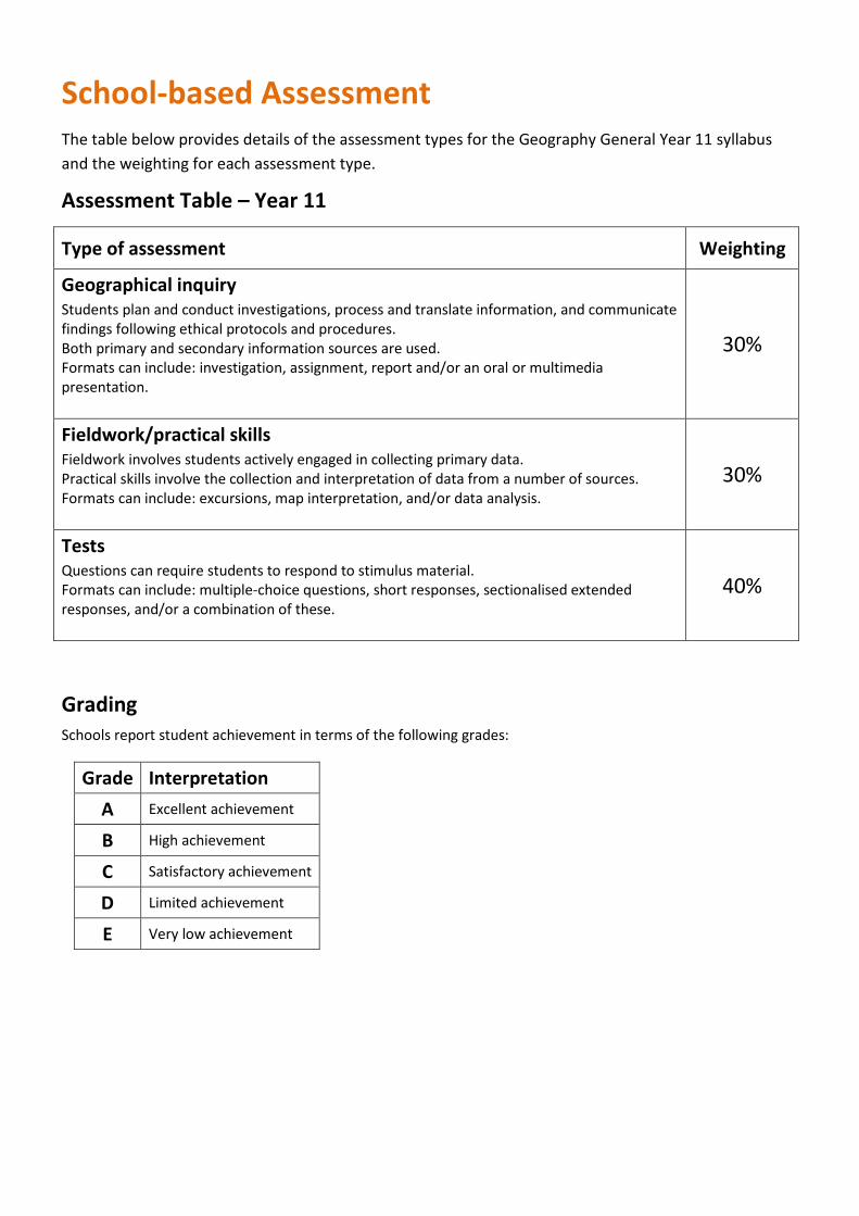
School-based Assessment
The table below provides details of the assessment types for the Geography General Year 11 syllabus and the weighting for each assessment type.
Assessment Table – Year 11
Type of assessment Weighting
Geographical inquiry Students plan and conduct investigations, process and translate information, and communicate findings following ethical protocols and procedures. Both primary and secondary information sources are used. Formats can include: investigation, assignment, report and/or an oral or multimedia presentation.
30%
Fieldwork/practical skills Fieldwork involves students actively engaged in collecting primary data. Practical skills involve the collection and interpretation of data from a number of sources. Formats can include: excursions, map interpretation, and/or data analysis.
30%
Tests Questions can require students to respond to stimulus material. Formats can include: multiple-choice questions, short responses, sectionalised extended responses, and/or a combination of these.
40%
Grading Schools report student achievement in terms of the following grades:
Grade Interpretation A Excellent achievement
B High achievement
C Satisfactory achievement
D Limited achievement
E Very low achievement
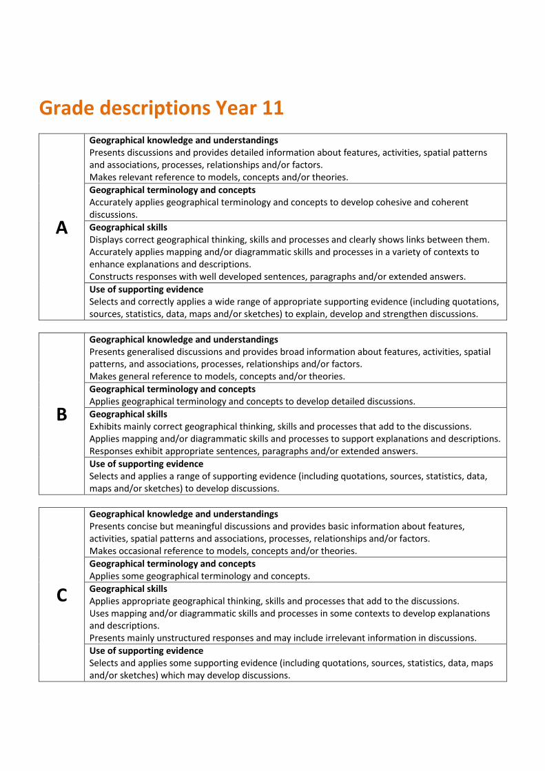
Grade descriptions Year 11
A
Geographical knowledge and understandings Presents discussions and provides detailed information about features, activities, spatial patterns and associations, processes, relationships and/or factors. Makes relevant reference to models, concepts and/or theories. Geographical terminology and concepts Accurately applies geographical terminology and concepts to develop cohesive and coherent discussions. Geographical skills Displays correct geographical thinking, skills and processes and clearly shows links between them. Accurately applies mapping and/or diagrammatic skills and processes in a variety of contexts to enhance explanations and descriptions. Constructs responses with well developed sentences, paragraphs and/or extended answers. Use of supporting evidence Selects and correctly applies a wide range of appropriate supporting evidence (including quotations, sources, statistics, data, maps and/or sketches) to explain, develop and strengthen discussions.
B
Geographical knowledge and understandings Presents generalised discussions and provides broad information about features, activities, spatial patterns, and associations, processes, relationships and/or factors. Makes general reference to models, concepts and/or theories. Geographical terminology and concepts Applies geographical terminology and concepts to develop detailed discussions. Geographical skills Exhibits mainly correct geographical thinking, skills and processes that add to the discussions. Applies mapping and/or diagrammatic skills and processes to support explanations and descriptions. Responses exhibit appropriate sentences, paragraphs and/or extended answers. Use of supporting evidence Selects and applies a range of supporting evidence (including quotations, sources, statistics, data, maps and/or sketches) to develop discussions.
C
Geographical knowledge and understandings Presents concise but meaningful discussions and provides basic information about features, activities, spatial patterns and associations, processes, relationships and/or factors. Makes occasional reference to models, concepts and/or theories. Geographical terminology and concepts Applies some geographical terminology and concepts. Geographical skills Applies appropriate geographical thinking, skills and processes that add to the discussions. Uses mapping and/or diagrammatic skills and processes in some contexts to develop explanations and descriptions. Presents mainly unstructured responses and may include irrelevant information in discussions. Use of supporting evidence Selects and applies some supporting evidence (including quotations, sources, statistics, data, maps and/or sketches) which may develop discussions.
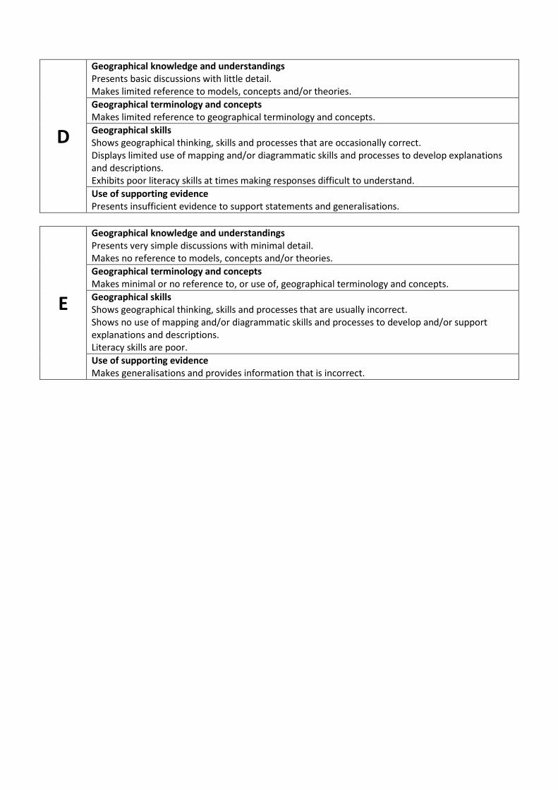
D
Geographical knowledge and understandings Presents basic discussions with little detail. Makes limited reference to models, concepts and/or theories. Geographical terminology and concepts Makes limited reference to geographical terminology and concepts. Geographical skills Shows geographical thinking, skills and processes that are occasionally correct. Displays limited use of mapping and/or diagrammatic skills and processes to develop explanations and descriptions. Exhibits poor literacy skills at times making responses difficult to understand. Use of supporting evidence Presents insufficient evidence to support statements and generalisations.
E
Geographical knowledge and understandings Presents very simple discussions with minimal detail. Makes no reference to models, concepts and/or theories. Geographical terminology and concepts Makes minimal or no reference to, or use of, geographical terminology and concepts. Geographical skills Shows geographical thinking, skills and processes that are usually incorrect. Shows no use of mapping and/or diagrammatic skills and processes to develop and/or support explanations and descriptions. Literacy skills are poor. Use of supporting evidence Makes generalisations and provides information that is incorrect.
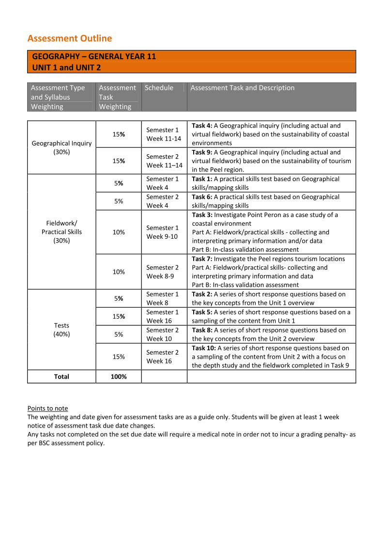
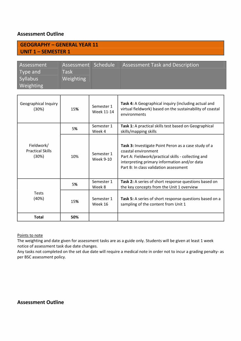
Assessment Outline
GEOGRAPHY – GENERAL YEAR 11 UNIT 1 and UNIT 2
Assessment Type and Syllabus Weighting
Assessment Task Weighting
Schedule Assessment Task and Description
Geographical Inquiry (30%)
15% Semester 1 Week 11-14
Task 4: A Geographical inquiry (including actual and virtual fieldwork) based on the sustainability of coastal environments
15% Semester 2 Week 11–14
Task 9: A Geographical inquiry (including actual and virtual fieldwork) based on the sustainability of tourism in the Peel region.
Fieldwork/ Practical Skills
(30%)
5% Semester 1 Week 4
Task 1: A practical skills test based on Geographical skills/mapping skills
5% Semester 2 Week 4
Task 6: A practical skills test based on Geographical skills/mapping skills
10% Semester 1 Week 9-10
Task 3: Investigate Point Peron as a case study of a coastal environment Part A: Fieldwork/practical skills - collecting and interpreting primary information and/or data Part B: In-class validation assessment
10% Semester 2 Week 8-9
Task 7: Investigate the Peel regions tourism locations Part A: Fieldwork/practical skills- collecting and interpreting primary information and data Part B: In-class validation assessment
Tests (40%)
5% Semester 1 Week 8
Task 2: A series of short response questions based on the key concepts from the Unit 1 overview
15% Semester 1 Week 16
Task 5: A series of short response questions based on a sampling of the content from Unit 1
5% Semester 2 Week 10
Task 8: A series of short response questions based on the key concepts from the Unit 2 overview
15% Semester 2 Week 16
Task 10: A series of short response questions based on a sampling of the content from Unit 2 with a focus on the depth study and the fieldwork completed in Task 9
Total 100%
Points to note The weighting and date given for assessment tasks are as a guide only. Students will be given at least 1 week notice of assessment task due date changes. Any tasks not completed on the set due date will require a medical note in order not to incur a grading penalty- as per BSC assessment policy.
Assessment Outline
GEOGRAPHY – GENERAL YEAR 11 UNIT 1 – SEMESTER 1
Assessment Type and Syllabus Weighting
Assessment Task Weighting
Schedule Assessment Task and Description
Geographical Inquiry (30%)
15% Semester 1
Week 11-14
Task 4: A Geographical inquiry (including actual and virtual fieldwork) based on the sustainability of coastal environments
Fieldwork/ Practical Skills
(30%)
5% Semester 1 Week 4
Task 1: A practical skills test based on Geographical skills/mapping skills
10% Semester 1 Week 9-10
Task 3: Investigate Point Peron as a case study of a coastal environment Part A: Fieldwork/practical skills - collecting and interpreting primary information and/or data Part B: In class validation assessment
Tests (40%)
5% Semester 1 Week 8
Task 2: A series of short response questions based on the key concepts from the Unit 1 overview
15% Semester 1 Week 16
Task 5: A series of short response questions based on a sampling of the content from Unit 1
Total 50%
Points to note The weighting and date given for assessment tasks are as a guide only. Students will be given at least 1 week notice of assessment task due date changes. Any tasks not completed on the set due date will require a medical note in order not to incur a grading penalty- as per BSC assessment policy.
Assessment Outline
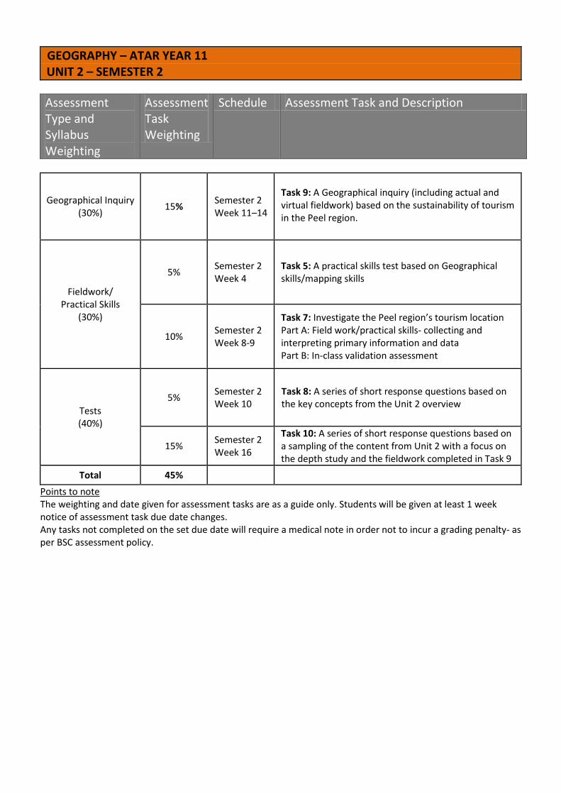
GEOGRAPHY – ATAR YEAR 11 UNIT 2 – SEMESTER 2 Assessment Type and Syllabus Weighting
Assessment Task Weighting
Schedule Assessment Task and Description
Geographical Inquiry (30%) 15% Semester 2
Week 11–14
Task 9: A Geographical inquiry (including actual and virtual fieldwork) based on the sustainability of tourism in the Peel region.
Fieldwork/ Practical Skills
(30%)
5% Semester 2 Week 4
Task 5: A practical skills test based on Geographical skills/mapping skills
10% Semester 2 Week 8-9
Task 7: Investigate the Peel region’s tourism location Part A: Field work/practical skills- collecting and interpreting primary information and data Part B: In-class validation assessment
Tests (40%)
5% Semester 2 Week 10
Task 8: A series of short response questions based on the key concepts from the Unit 2 overview
15% Semester 2 Week 16
Task 10: A series of short response questions based on a sampling of the content from Unit 2 with a focus on the depth study and the fieldwork completed in Task 9
Total 45% Points to note The weighting and date given for assessment tasks are as a guide only. Students will be given at least 1 week notice of assessment task due date changes. Any tasks not completed on the set due date will require a medical note in order not to incur a grading penalty- as per BSC assessment policy.
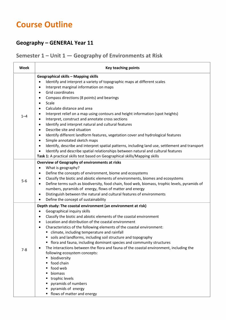
Course Outline
Geography – GENERAL Year 11 Semester 1 – Unit 1 — Geography of Environments at Risk
Week Key teaching points
1–4
Geographical skills – Mapping skills • Identify and interpret a variety of topographic maps at different scales • Interpret marginal information on maps • Grid coordinates • Compass directions (8 points) and bearings • Scale • Calculate distance and area • Interpret relief on a map using contours and height information (spot heights) • Interpret, construct and annotate cross sections • Identify and interpret natural and cultural features • Describe site and situation • Identify different landform features, vegetation cover and hydrological features • Simple annotated sketch maps • Identify, describe and interpret spatial patterns, including land use, settlement and transport • Identify and describe spatial relationships between natural and cultural features
Task 1: A practical skills test based on Geographical skills/Mapping skills
5-6
Overview of Geography of environments at risks • What is geography? • Define the concepts of environment, biome and ecosystems • Classify the biotic and abiotic elements of environments, biomes and ecosystems • Define terms such as biodiversity, food chain, food web, biomass, trophic levels, pyramids of
numbers, pyramids of energy, flows of matter and energy • Distinguish between the natural and cultural features of environments • Define the concept of sustainability
7-8
Depth study: The coastal environment (an environment at risk) • Geographical inquiry skills • Classify the biotic and abiotic elements of the coastal environment • Location and distribution of the coastal environment • Characteristics of the following elements of the coastal environment: climate, including temperature and rainfall soils and landforms, including soil structure and topography flora and fauna, including dominant species and community structures
• The interactions between the flora and fauna of the coastal environment, including the following ecosystem concepts: biodiversity food chain food web biomass trophic levels pyramids of numbers pyramids of energy flows of matter and energy
Week Key teaching points
Task 2: A series of short response questions based on the key concepts from the Unit 1 overview
9–10
• Interrelationships between biotic and abiotic elements of the coastal environment • Describe human activity and land use impacts upon patterns and processes within the coastal
environment • Identify the cultural landscapes associated with the coastal environment
Task 3: Investigate Point Peron as a case study of a coastal environment Part A: Fieldwork/practical skills – collecting and interpreting primary information and/or data and using Geographical inquiry skills Part B: A test based on the fieldwork and class work on the coastal environment including Point Peron.
11–14
• Identify the economic, political and social factors that impact upon decisions about sustainability of the coastal environment
• Identify the different values and viewpoints (environmental, economic and social) that shape the human use of the coastal environment
• Benefits of implementing sustainable practices within the coastal environment • The extent to which current land use practices are sustainable within a coastal environment • Measures by which humans are caring for the coastal environment: and the extent to which
these measures have been successful Task 4: A Geographical inquiry (including actual and virtual fieldwork) based on the sustainability of coastal environments
15 Revision 16 Task 5: A series of short response questions based on a sampling of the content from Unit 1
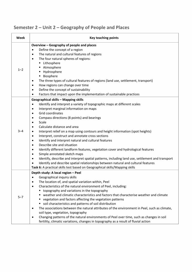
Semester 2 – Unit 2 – Geography of People and Places
Week Key teaching points
1–2
Overview – Geography of people and places • Define the concept of a region • The natural and cultural features of regions • The four natural spheres of regions:
Lithosphere Atmosphere Hydrosphere Biosphere
• The three types of cultural features of regions (land use, settlement, transport) • How regions can change over time • Define the concept of sustainability • Factors that impact upon the implementation of sustainable practices
3–4
Geographical skills – Mapping skills • Identify and interpret a variety of topographic maps at different scales • Interpret marginal information on maps • Grid coordinates • Compass directions (8 points) and bearings • Scale • Calculate distance and area • Interpret relief on a map using contours and height information (spot heights) • Interpret, construct and annotate cross sections • Identify and interpret natural and cultural features • Describe site and situation • Identify different landform features, vegetation cover and hydrological features • Simple annotated sketch maps • Identify, describe and interpret spatial patterns, including land use, settlement and transport • Identify and describe spatial relationships between natural and cultural features Task 6: A practical skills test based on Geographical skills/Mapping skills
5–7
Depth study: A local region – Peel • Geographical inquiry skills • The location of, and spatial variation within, Peel • Characteristics of the natural environment of Peel, including:
topography and variations in the topography weather and climatic characteristics and factors that characterise weather and climate vegetation and factors affecting the vegetation patterns soil characteristics and patterns of soil distribution
• The associations between the natural attributes of the environment in Peel, such as climate, soil type, vegetation, topography
• Changing patterns of the natural environments of Peel over time, such as changes in soil fertility, climatic variations, changes in topography as a result of fluvial action
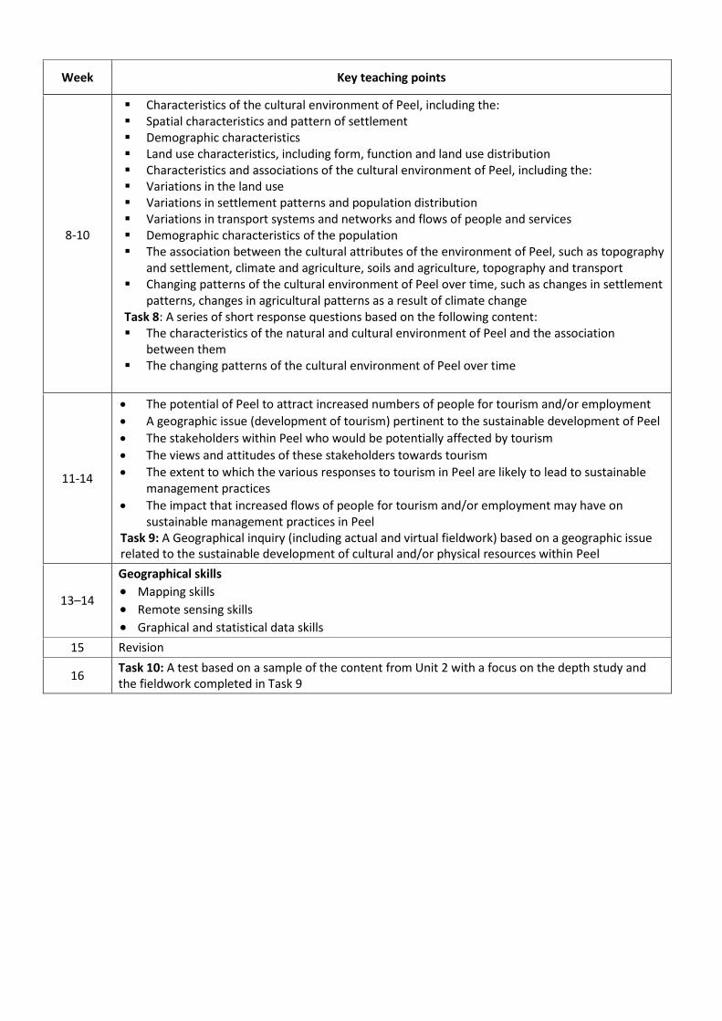
Week Key teaching points
8-10
Characteristics of the cultural environment of Peel, including the: Spatial characteristics and pattern of settlement Demographic characteristics Land use characteristics, including form, function and land use distribution Characteristics and associations of the cultural environment of Peel, including the: Variations in the land use Variations in settlement patterns and population distribution Variations in transport systems and networks and flows of people and services Demographic characteristics of the population The association between the cultural attributes of the environment of Peel, such as topography
and settlement, climate and agriculture, soils and agriculture, topography and transport Changing patterns of the cultural environment of Peel over time, such as changes in settlement
patterns, changes in agricultural patterns as a result of climate change Task 8: A series of short response questions based on the following content: The characteristics of the natural and cultural environment of Peel and the association
between them The changing patterns of the cultural environment of Peel over time
11-14
• The potential of Peel to attract increased numbers of people for tourism and/or employment • A geographic issue (development of tourism) pertinent to the sustainable development of Peel • The stakeholders within Peel who would be potentially affected by tourism • The views and attitudes of these stakeholders towards tourism • The extent to which the various responses to tourism in Peel are likely to lead to sustainable
management practices • The impact that increased flows of people for tourism and/or employment may have on
sustainable management practices in Peel Task 9: A Geographical inquiry (including actual and virtual fieldwork) based on a geographic issue related to the sustainable development of cultural and/or physical resources within Peel
13–14
Geographical skills • Mapping skills • Remote sensing skills • Graphical and statistical data skills
15 Revision
16 Task 10: A test based on a sample of the content from Unit 2 with a focus on the depth study and the fieldwork completed in Task 9