Embed Size (px)
Citation preview
WITSML Lithology Element Usage Guide For WITSML Version 1.4.1
WITSML Overview
The Wellsite Information Transfer Standard Mark-up Language (WITSML) consists of XML data-object definitions and a Web services specification developed to promote the right-time, seamless flow of well data between operators and service companies to speed and enhance decision making.
Version: Version 1.01
Abstract This document is a guide for implementing and using the lithology element of the mudLog data-object. This lithology element was significantly modified and released as part of WITSML v1.4.1.
Prepared by: WITSML SIG Lithology Sub-team
Date published: 18 November 2011
Minor revisions January 2012
Document type: Usage Guide
Keywords: Data exchange standard, lithology, data, information, qualifier, matrix cement
WITSML Lithology Element Usage Guide
Version 1.01/January 2012 1
Document Information
DOCUMENT VERSION: 1.01
DATE: January 2012
Technical
Language US English
.
Usage, Intellectual Property Rights, and Copyright
The material described in this document was developed by and is the intellectual property of Energistics. Energistics develops material for open, public use so that the material is accessible and can be of maximum value to everyone.
Use of the material in this document is governed by the Energistics Intellectual Property Policy document and the Product Licensing Agreement, both of which can be found on the Energistics website, http://www.energistics.org/legal-policies.
All Energistics published materials are freely available for public comment and use. Anyone may copy and share the materials but must always acknowledge Energistics as the source. No one may restrict use or dissemination of Energistics materials in any way.
Trademarks
Energistics™, POSC®, Epicentre®, WITSML™, PRODML™, Upstream Standards. Bottom Line Results.™, The Energy Standards Resource Centre™ and their logos are trademarks or registered trademarks of Energistics. Access, receipt, and/or use of these documents and all Energistics materials are generally available to the public and are specifically governed by the Energistics Product Licensing Agreement (http://www.energistics.org/product-license-agreement)

WITSML Lithology Element Usage Guide
Version 1.01/January 2012 2
Amendment History
Version Date Comment By
1.0 18 November 2011
Guide developed based on the Lithology Sub-team's work to clean up and clarify contents and use of the lithology element of the mudLog data-object.
WITSML SIG Lithology Sub-team
1.01 December 2011 Minor text changes to clarify areas such as planned objects, and to replace manually generated sample code with exported data.
WITSML SIG Lithology Sub-team

WITSML Lithology Element Usage Guide
Version 1.01/January 2012 3
Table of Contents Table of Contents ................................................................................................................. 3
Executive Summary.............................................................................................................. 4
1 Introduction................................................................................................................... 6
1.1 Lithology Element in WITSML ................................................................................... 6 1.2 Audience, Purpose, and Objectives .......................................................................... 6
1.2.1 Key Business Objectives.................................................................................... 6 1.2.2 Objectives.......................................................................................................... 7
1.3 Alternate Standards .................................................................................................. 7 1.4 Business Processes ................................................................................................. 7 1.5 Business Case ......................................................................................................... 7 1.6 Related Resources ................................................................................................... 8 1.7 Road Map ................................................................................................................. 8
2 Scope of Lithology Element ......................................................................................... 9
3 Coding Examples ........................................................................................................ 11
3.1 Example XML ......................................................................................................... 12 3.1.1 Chrono and Lithostratigraphy example ............................................................. 12 3.1.2 Prognosed Lithology ........................................................................................ 16
4 Enumeration Tables .................................................................................................... 17
5 Stratigraphy ................................................................................................................ 18
Appendix A. References ................................................................................................. 19
Appendix B. Changes between 1.3 and 1.4.1 ................................................................. 20
B.1 Key Changes .......................................................................................................... 20 B.2 Affected Schemas in the Change to 1.4.1 ............................................................... 20
Appendix C. Lithology Descriptions ............................................................................... 21
Appendix D. Design Concepts for 1.4.1.......................................................................... 22
D.1 WITSML - Lithology Component Schema Changes ................................................. 22 D.2 Example of the Usage Changes from 1.3 ................................................................ 23
Appendix E. Change to Chronostratigraphy and Lithostratigraphy. ............................ 25
E.1 Usage Examples .................................................................................................... 26
Appendix F. Errors in Implementing 1.4.1 Changes ...................................................... 27
F.1 Chronostratigraphy Terminology. ............................................................................ 27
Appendix G. Known Errors in Schemas ......................................................................... 31
Appendix H. Suggested Changes to Other Schemas. ................................................... 32
Appendix I. Other Lithology Standards ........................................................................ 33
I.1 ISO Standards for Rocks ........................................................................................ 33 I.2 IODP work .............................................................................................................. 33 I.3 XMML ..................................................................................................................... 34 I.4 BP/Statoil Coring Project ........................................................................................ 34 I.5 GeoSciML .............................................................................................................. 34 I.6 OneGeology www.onegeology.org .......................................................................... 34 I.7 Shell 1995 Geology Standard Legend ..................................................................... 35 I.8 British Geological Survey Standards ....................................................................... 35 I.9 United States Geological Survey Data Model .......................................................... 36 I.10 Norwegian Petroleum Directorate Data Standard .................................................... 36 I.11 Mud Logging Documentation .................................................................................. 37
Appendix J. Stratigraphy Color Mapping....................................................................... 38
WITSML Lithology Element Usage Guide
Version 1.01/January 2012 4
Executive Summary Wellsite lithology is a key geological parameter observed and recorded by the mud logging geologist or the wellsite geologist at the rig, based on descriptions of drill cuttings, core, sidewall cores, and rock fragments. This data is essential in determining the stratigraphic depth of the well, and the geological context for pore fluids.
The data is typically plotted as a “prognosed” or “observed” graphical lithology column, a written textual description in a structured order, and optionally an “Interpreted” or inferred lithology column. The graphical lithology representations may also have additional graphical representations of Qualifiers, additionally observed lithological features. The log may also have additional columns representing the geological location in terms of the date of the rocks, in the format of the international chronostratigraphic standards, and optionally columns denoting the local terminology for the lithostratigraphy.
Operating companies have to report lithology to partners and regulatory authorities, as well as using the information in daily well decisions, and decisions at key points in the well, such as casing shoe picks and geosteering. Improving the quality of the lithology information will also ensure the geological data at the wellsite has more value in operating company workflows, beyond just the timeframe of the Operations Geology activity while the well is being drilled. Typically the wellsite work of a mud logging contractor is codified by the operator in “Wellsite Geology Composite Log”, at the end of a well, when laboratory data for the chronostratigraphy is also available. The intent is to enable all the items for a composite log to be delivered by WITSML.
The lithology element in earlier implementations of WITSML has lacked adequate description on intended usage, leading to interoperability issues between vendors, and lacked geological definitions for the terminology used. The geological dictionary used was a compromise between companies. Where appropriate to wellsite use, this version mainly uses the terminology and definitions of a subset of the Interoperability Working Group of the Commission for the Management and Application of Geoscience Information, (CGI ) developed by OneGeology Europe (OneGeology ). Many of these definitions are relatively recent that postdate most current wellsite practice, but that should change. The OneGeology Europe definitions are consistent, but the GeoSciML CGI definitions include duplication and overlap. However the OneGeology Europe definitions exclude the carbonate depositional definitions in widespread use in the petroleum community, some of which, but not all, are included in the CGI definitions.
The standard for this version is principally intended for the implementation of the graphical columns for lithology and anticipates the use of a free text entry for the description. It is possible in the future the standard may be used to generate a structured text description from discrete entries, enabling the generation of a structured textual description, and so some of terminology has been better defined to enable that usage.
The revised terminology for lithology, revised terminology for qualifiers and the addition of matrix cement in the WITSML enumeration file, a revised style sheet and this implementation guide were created by the Lithology Sub-team of the WITSMLSpecial Interest Group (SIG).
WITSML Lithology Element Usage Guide
Version 1.01/January 2012 6
1 Introduction Lithology data gathered and recorded while drilling wells can be used to inform drilling decisions and serve as input to earth models. The data consists of two broad categories:
Numeric measurements of properties such as ROP, gas, resistivity, gamma, etc..
Textual descriptions of the lithology components.
However, today the industry largely loses the value of the wellsite observations of lithology, its interpretation, and sample descriptions within six months of the well completion, because the data is presented simply as an image from proprietary packages, and the lithology components and their descriptions do not become part of the long term digital record of the well in corporate enterprise stores, beyond the tools of the operations geology groups.
1.1 Lithology Element in WITSML
To help address this problem of losing data and its value to upstream operations, and to improve interoperability between software packages using this data, the lithology element in WITSML (Wellsite Information Transfer Standard Markup Language) has been further clarified and developed. The lithology element is part of these WITSML data-objects:
mudLog data-object. Lithology is an element of the geologyInterval sub-data-object to describe the lithology of an interval of a wellbore.
sidewallCore data-object. Lithology is an element of the swcSample child element used to describe the lithology of a core from a wellbore.
1.2 Audience, Purpose, and Objectives
The intended audience for this document is those coding applications for implementation of lithology in WITSML.
The purpose of this document is to provide a good understanding of the business application of the lithology element and some coding examples to help with implementation. This document focuses on the business case of performing a mud log while drilling a well and does not include information on coring. For more information, see sections 1.4 and 1.5 below.
This document also addresses how future evolution of the lithology element may align with similar future efforts, which through the influence of national geological surveys, will in time influence regulatory reporting.
1.2.1 Key Business Objectives
Consistent data terminology to eliminate confusion in the interpretation of the data with rigorous geological definition appropriate for wellsite usage
Consistent data formats to simplify transformation of the data into the well operator’s data systems, and preserve long term value of the wellsite observations beyond the operations geology involvement
Reduce the service company’s cost of preparing and delivering data to the well operator
Rendering that is based on Operator preferences, with identical code from every contractor, for the same lithology.
Reduce the well operator’s cost of managing lithology data, especially in the area of regulatory reporting
Enable future usage of structured text approaches, or gathering of statistical data on, for example sorting of clastics.
Retain compatibility by retaining all the prior terms, though suggesting which are deprecated for the 1.4.1 structure.
WITSML Lithology Element Usage Guide
Version 1.01/January 2012 7
1.2.2 Objectives
The intention of the lithology data in WITSML is to:
Enable applications other than the originating application to correctly render the information observed and interpreted at the wellsite into an observed lithology column, an interpreted lithology column and a text description, irrespective of the service provider collecting the data. The qualifier data at this point is solely for use in the rendering of the graphics of the lithology columns. This information should be satisfactory for the regulatory reports that include geology data, such as the POSC/ Caesar/OLF Norwegian daily reporting XML data changes being made in 2011.
Provide a placeholder for the recording and digital transfer of manual measurements of geological properties made on the cuttings and core sample, such as show, porosity, shale density and calcimetry, which are frequently shown as blocked in areas of the mud log to highlight areas of porosity and shows.
Create an optional, alternate framework to the free text description for the recording of the geologists observations, in a structured form which will allow the end client application to generate an equivalent of the current free text description. This allows both statistical comparisons of the data between wells, and the potential to render the description in languages other than the language of the observer. The original documentation will be English, but through look-up tables a structured approach would allow both non-English speaking geologists to enter the data, say through a Russian front-end application, and allow the rendering of the text in any other language for which the look-up tables have been created. This also would enable operator specific abreviations to be generated from the standard lithology types.
OneGeology have started this process for lithology for all languages used in the European Union (EU). This approach has been used in our industry in the past, notably in a BP/Statoil slim-hole coring
project, ( See I.4 ) but did not gain acceptance due to the challenge of developing a user interface
which could be used as quickly as typing free text. However advances in user interface tools and low cost touchscreen technologies make this a potential for the near term.
1.3 Alternate Standards
The intention where possible is to enable interoperability of terminology and definitions with OneGeology standards, and GeoSciML but not to use the same XML structure, which differs significantly from the WITSML structure. For a complete list of related and referenced standards, see Other Lithology Standards, page 33.
1.4 Business Processes
The assumption is that the wellsite geology processes will be as documented in AAPG and SPWLA standards, and where appropriate using the Shell 1995 approach to terminology, which can be found on the Energistics site. Individual operators have their own detailed standards, but these typically follow the AAPG approach.
1.5 Business Case
The business case for Lithology is a little different to that for the true real-time data.
The lithology entries typically go through a three stage cycle, a pre drill prognosis, the wellsite observation by a mud logging contractor, who produces the observed lithology from cuttings or core. In many cases the observation then undergoes a third cycle, either by the mud logging contractor, or a wellsite geologist (either from the operating company or a separate contract) or onshore by an operations geologist with access to additional tests such as micropaleontology, to confirm the chronstratigraphy. In a development well in a mature field, the lithostratigraphy and chronostratigraphy may be well defined and mature, in rank wildcats, the lithostratigraphy may be well specific picks from the pre drill seismic sections.
After the well, in addition to the mud log, a final composite log is frequently produced, and the lithology data today is typically rekeyed between the two products, or the composite reflects the wellsite geologist’s data entry. One of the business cases for WITSML lithology is the ease of transfer of data between the mud logging contractor’s proprietary data entry software, and the operator's choice of composite log drawing packages.
WITSML Lithology Element Usage Guide
Version 1.01/January 2012 8
The principle business case however is that the industry today largely loses the value of the wellsite observations of lithology, its interpretation, and sample descriptions within six months of the well completion, as the data is presented simply as image data from proprietary packages, and the lithology components and their descriptions do not become part of the long term digital record of the well in corporate enterprise stores, beyond the tools of the operations geology groups. The composite log drawing tools are operations geology tools, and without a digital standard for the lithology columns or descriptions, only the linear numeric logging measurements of ROP, gas, resistivity, gamma etc., are retained in enterprise log repositories. This loss of the wellsite observations in a digital form for long term use during the life of the well represents a significant loss of value to the industry. A robust standard, allowing the enterprise tools to use the lithology data in the same way as the numeric data, will preserve the value, and elevate the status of the geologist’s efforts at the wellsite.
The ability by the enterprise log archiving and processing tools to accept exports of data from the mud logging contractors and the composite log plotting packages is dependent on a clear standard that is readily interoperable between systems.
1.6 Related Resources
For more information about implementing WITSML see documentation contained within the individual schemas and the WITSML Store API document, which are all available at http://www.energistics.org/witsml-standard.
1.7 Road Map
Future work related to lithology in WITSML may include:
Monitor OneGeology and GeoSciML vocabularies with a view to further future alignment. It is probable that more detail from the CGI vocabulary will be adopted to further augment the sedimentary definitions, but fewer of the igneous terms will be retained. Align with vocabularies, and engage to suggest they align with WITSML in areas not currently covered by GeoSciML.
Make the needed changes to cs_show to reflect the same approach as taken in cs_lithology.
Link the reporting references from datatypes such as cs_drillReportStratInfo and cs_drillReportLithShowInfo into the same approach.
Develop the lithology information from sidewall core, core and cs_geologyInterval into a daily geology report data-object and ensure the needs for daily geological reporting can be met through WITSML.
Align the formationMarker object useage with the lithology, chronostratigraphy and lithostratigraphy changes made here, and agree with ResqML their needs for this object.
Review other areas of geological standards in WITSML where the definitions are still unclear, such as show evaluation, and suggest tighter definitions.
Prepare sample code for the complete mud log object for a typical clastic and a typical carbonate sequence, including a pre drill prognosis.
Include this content into a mudLog object usage guide when that document is developed.
WITSML Lithology Element Usage Guide
Version 1.01/January 2012 9
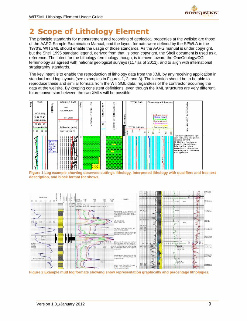
2 Scope of Lithology Element The principle standards for measurement and recording of geological properties at the wellsite are those of the AAPG Sample Examination Manual, and the layout formats were defined by the SPWLA in the 1970’s. WITSML should enable the usage of those standards. As the AAPG manual is under copyright, but the Shell 1995 standard legend, derived from that, is open copyright, the Shell document is used as a reference. The intent for the Lithology terminology though, is to move toward the OneGeology/CGI terminology as agreed with national geological surveys (117 as of 2011), and to align with international stratigraphy standards.
The key intent is to enable the reproduction of lithology data from the XML by any receiving application in standard mud log layouts (see examples in Figures 1, 2, and 3). The intention should be to be able to reproduce these and similar formats from the WITSML data, regardless of the contractor acquiring the data at the wellsite. By keeping consistent definitions, even though the XML structures are very different, future conversion between the two XMLs will be possible.
Figure 1 Log example showing observed cuttings lithology, interpreted lithology with qualifiers and free text description, and block format for shows.
Figure 2 Example mud log formats showing show representation graphically and percentage lithologies.
WITSML Lithology Element Usage Guide
Version 1.01/January 2012 10
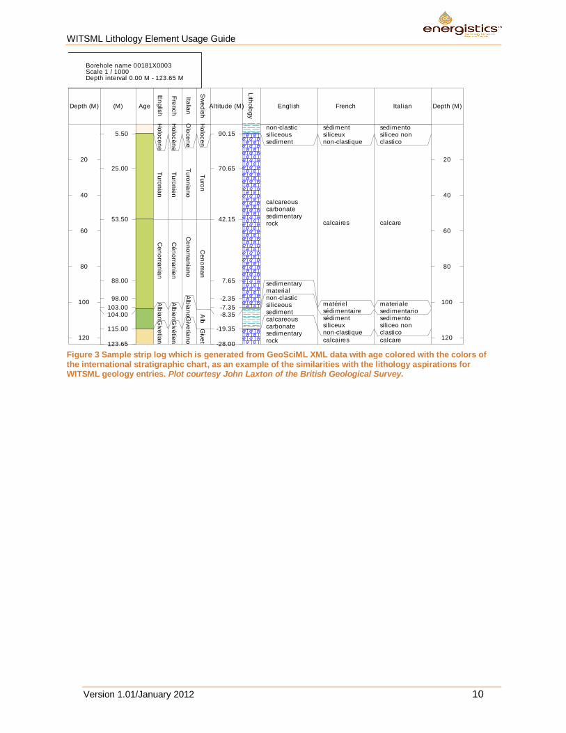
Figure 3 Sample strip log which is generated from GeoSciML XML data with age colored with the colors of the international stratigraphic chart, as an example of the similarities with the lithology aspirations for WITSML geology entries. Plot courtesy John Laxton of the British Geological Survey.
20
40
60
80
100
120
5.50
25.00
53.50
88.00
98.00
103.00104.00
115.00
123.65
Ho
loce
ne
Tu
ron
ian
Ce
no
ma
nia
nA
lbia
nG
ive
tian
Ho
locè
ne
Tu
ron
ien
Cé
no
ma
nie
nA
lbie
nG
ivé
tien
Olo
ce
ne
Tu
ron
ian
oC
en
om
an
ian
oA
lbia
noG
ive
tian
o
Ho
loce
nT
uro
nC
en
om
an
Alb
Giv
et
90.15
70.65
42.15
7.65
-2.35
-7.35-8.35
-19.35
-28.00
non-clasticsi liceoussediment
calcareouscarbonatesedimentaryrock
sedimentarymaterialnon-clasticsi liceoussedimentcalcareouscarbonatesedimentaryrock
sédimentsi liceuxnon-clastique
calcaires
matérielsédimentairesédimentsi liceuxnon-clastique
calcaires
sedimentosi liceo nonclastico
calcare
materialesedimentariosedimentosi liceo nonclastico
calcare
20
40
60
80
100
120
Borehole name 00181X0003Scale 1 / 1000Depth interval 0.00 M - 123.65 M
Depth (M) (M) Age
En
glis
h
Fre
nch
Italia
n
Sw
ed
ish
Alti tude (M)
Lith
olo
gy
Engl ish French Ital ian Depth (M)
WITSML Lithology Element Usage Guide
Version 1.01/January 2012 11
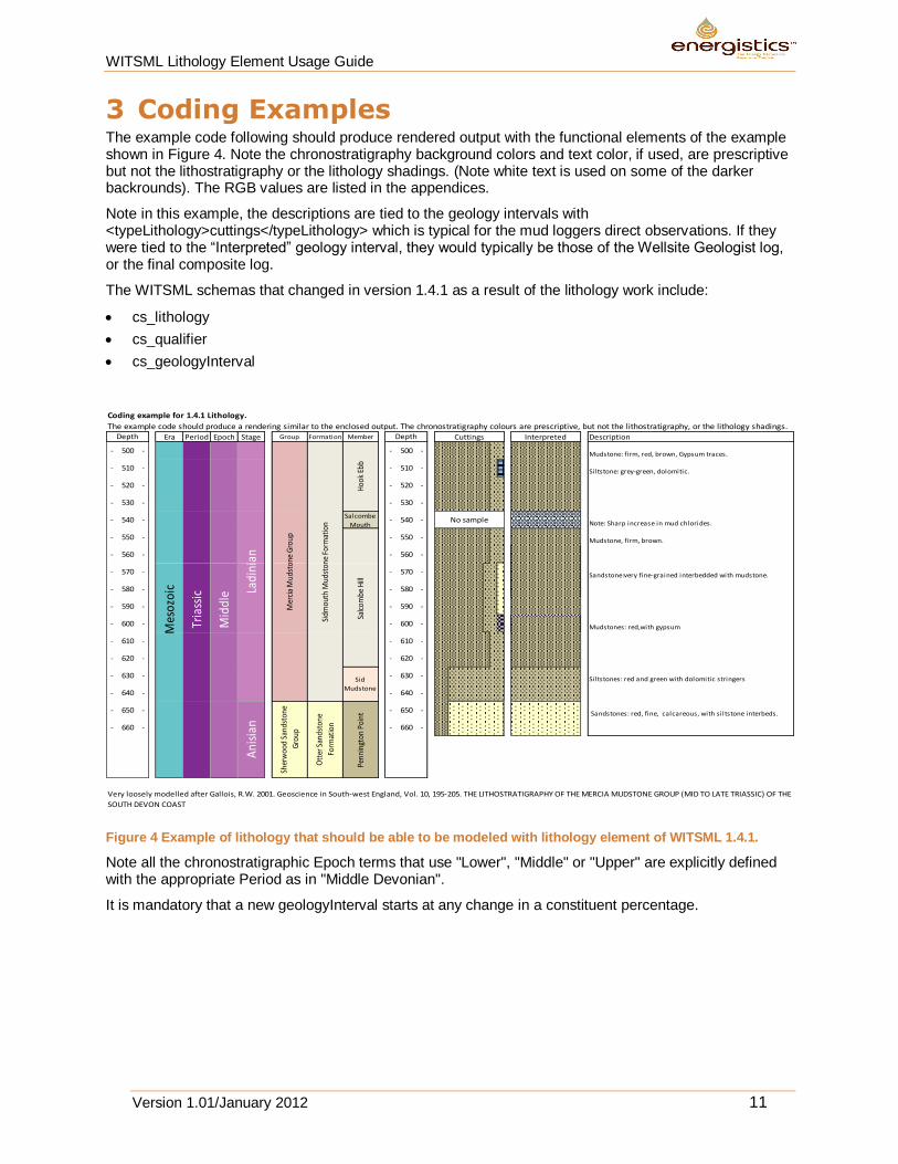
3 Coding Examples The example code following should produce rendered output with the functional elements of the example shown in Figure 4. Note the chronostratigraphy background colors and text color, if used, are prescriptive but not the lithostratigraphy or the lithology shadings. (Note white text is used on some of the darker backrounds). The RGB values are listed in the appendices.
Note in this example, the descriptions are tied to the geology intervals with <typeLithology>cuttings</typeLithology> which is typical for the mud loggers direct observations. If they were tied to the “Interpreted” geology interval, they would typically be those of the Wellsite Geologist log, or the final composite log.
The WITSML schemas that changed in version 1.4.1 as a result of the lithology work include:
cs_lithology
cs_qualifier
cs_geologyInterval
Coding example for 1.4.1 Lithology.
The example code should produce a rendering similar to the enclosed output. The chronostratigraphy colours are prescriptive, but not the lithostratigraphy, or the lithology shadings.Era Period Epoch Stage Group Formation Member Description
- 500 - - 500 - Mudstone: firm, red, brown, Gypsum traces.
- 510 - - 510 - Siltstone: grey-green, dolomitic.
- 520 - - 520 -
- 530 - - 530 -
- 540 -Salcombe
Mouth- 540 - Note: Sharp increase in mud chlorides.
- 550 - - 550 - Mudstone, firm, brown.
- 560 - - 560 -
- 570 - - 570 - Sandstone:very fine-grained interbedded with mudstone.
- 580 - - 580 -
- 590 - - 590 -
- 600 - - 600 - Mudstones: red,with gypsum
- 610 - - 610 -
- 620 - - 620 -
- 630 - - 630 - Siltstones: red and green with dolomitic stringers
- 640 - - 640 -
- 650 - - 650 - Sandstones: red, fine, calcareous, with siltstone interbeds.
- 660 - - 660 -
Hoo
k Eb
bSa
lcom
be H
ill
Sid
Mudstone
Mer
cia
Mud
ston
e G
roup
Sher
woo
d Sa
ndst
one
Gro
up
Sidm
outh
Mud
ston
e Fo
rmat
ion
Ott
er S
ands
tone
Form
atio
n
Very loosely modelled after Gallois, R.W. 2001. Geoscience in South-west England, Vol. 10, 195-205. THE LITHOSTRATIGRAPHY OF THE MERCIA MUDSTONE GROUP (MID TO LATE TRIASSIC) OF THE
SOUTH DEVON COAST
Depth Depth Interpreted
Mes
ozoi
c
Tria
ssic
Mid
dle La
dini
anA
nisi
an
Cuttings
No sample
Penn
ingt
on P
oint
Figure 4 Example of lithology that should be able to be modeled with lithology element of WITSML 1.4.1.
Note all the chronostratigraphic Epoch terms that use "Lower", "Middle" or "Upper" are explicitly defined with the appropriate Period as in "Middle Devonian".
It is mandatory that a new geologyInterval starts at any change in a constituent percentage.
WITSML Lithology Element Usage Guide
Version 1.01/January 2012 12
3.1 Example XML
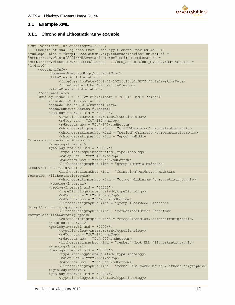
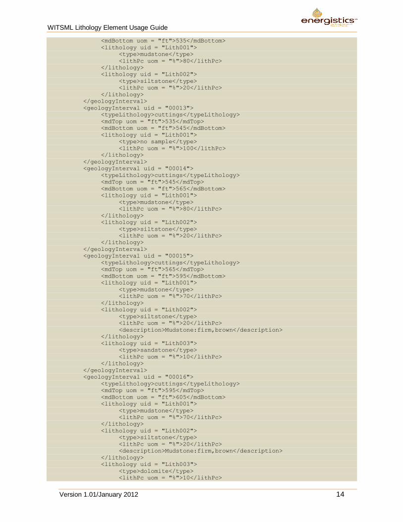
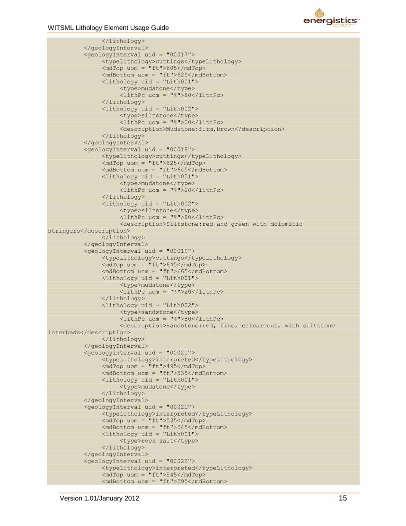
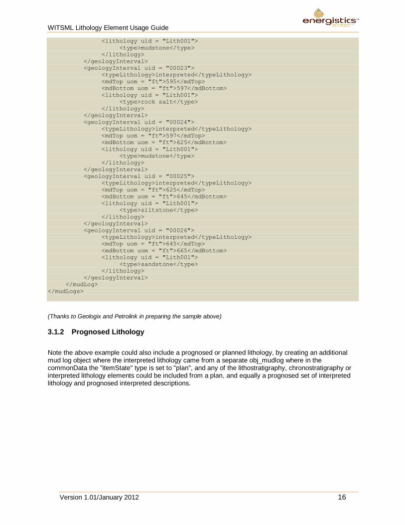
3.1.1 Chrono and Lithostratigraphy example
<?xml version="1.0" encoding="UTF-8"?>
<!--Example of Mud Log data From Lithology Element User Guide -->
<mudLogs xmlns = "http://www.witsml.org/schemas/1series" xmlns:xsi =
"http://www.w3.org/2001/XMLSchema-instance" xsi:schemaLocation =
"http://www.witsml.org/schemas/1series ../xsd_schemas/obj_mudLog.xsd" version =
"1.4.1.0">
<documentInfo>
<documentName>mudLog</documentName>
<fileCreationInformation>
<fileCreationDate>2011-12-15T16:15:31.827Z</fileCreationDate>
<fileCreator>John Smith</fileCreator>
</fileCreationInformation>
</documentInfo>
<mudLog uidWell = "W-12" uidWellbore = "B-01" uid = "h45a">
<nameWell>W-12</nameWell>
<nameWellbore>B-01</nameWellbore>
<name>Exmouth Marina #1</name>
<geologyInterval uid = "00001">
<typeLithology>interpreted</typeLithology>
<mdTop uom = "ft">495</mdTop>
<mdBottom uom = "ft">670</mdBottom>
<chronostratigraphic kind = "era">Mesozoic</chronostratigraphic>
<chronostratigraphic kind = "period">Triassic</chronostratigraphic>
<chronostratigraphic kind = "epoch">Middle
Triassic</chronostratigraphic>
</geologyInterval>
<geologyInterval uid = "00002">
<typeLithology>interpreted</typeLithology>
<mdTop uom = "ft">495</mdTop>
<mdBottom uom = "ft">645</mdBottom>
<lithostratigraphic kind = "group">Mercia Mudstone
Group</lithostratigraphic>
<lithostratigraphic kind = "formation">Sidmouth Mudstone
Formation</lithostratigraphic>
<chronostratigraphic kind = "stage">Ladinian</chronostratigraphic>
</geologyInterval>
<geologyInterval uid = "00003">
<typeLithology>interpreted</typeLithology>
<mdTop uom = "ft">645</mdTop>
<mdBottom uom = "ft">670</mdBottom>
<lithostratigraphic kind = "group">Sherwood Sandstone
Group</lithostratigraphic>
<lithostratigraphic kind = "formation">Otter Sandstone
Formation</lithostratigraphic>
<chronostratigraphic kind = "stage">Anisian</chronostratigraphic>
</geologyInterval>
<geologyInterval uid = "00004">
<typeLithology>interpreted</typeLithology>
<mdTop uom = "ft">495</mdTop>
<mdBottom uom = "ft">535</mdBottom>
<lithostratigraphic kind = "member">Hook Ebb</lithostratigraphic>
</geologyInterval>
<geologyInterval uid = "00005">
<typeLithology>interpreted</typeLithology>
<mdTop uom = "ft">535</mdTop>
<mdBottom uom = "ft">545</mdBottom>
<lithostratigraphic kind = "member">Salcombe Mouth</lithostratigraphic>
</geologyInterval>
<geologyInterval uid = "00006">
<typeLithology>interpreted</typeLithology>
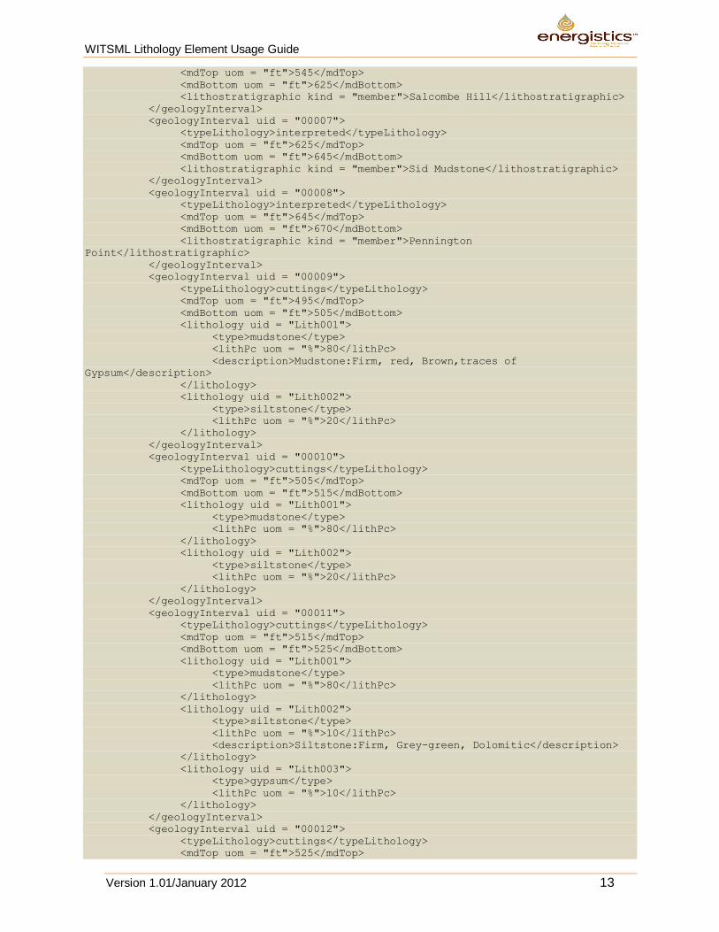
WITSML Lithology Element Usage Guide
Version 1.01/January 2012 13
<mdTop uom = "ft">545</mdTop>
<mdBottom uom = "ft">625</mdBottom>
<lithostratigraphic kind = "member">Salcombe Hill</lithostratigraphic>
</geologyInterval>
<geologyInterval uid = "00007">
<typeLithology>interpreted</typeLithology>
<mdTop uom = "ft">625</mdTop>
<mdBottom uom = "ft">645</mdBottom>
<lithostratigraphic kind = "member">Sid Mudstone</lithostratigraphic>
</geologyInterval>
<geologyInterval uid = "00008">
<typeLithology>interpreted</typeLithology>
<mdTop uom = "ft">645</mdTop>
<mdBottom uom = "ft">670</mdBottom>
<lithostratigraphic kind = "member">Pennington
Point</lithostratigraphic>
</geologyInterval>
<geologyInterval uid = "00009">
<typeLithology>cuttings</typeLithology>
<mdTop uom = "ft">495</mdTop>
<mdBottom uom = "ft">505</mdBottom>
<lithology uid = "Lith001">
<type>mudstone</type>
<lithPc uom = "%">80</lithPc>
<description>Mudstone:Firm, red, Brown,traces of
Gypsum</description>
</lithology>
<lithology uid = "Lith002">
<type>siltstone</type>
<lithPc uom = "%">20</lithPc>
</lithology>
</geologyInterval>
<geologyInterval uid = "00010">
<typeLithology>cuttings</typeLithology>
<mdTop uom = "ft">505</mdTop>
<mdBottom uom = "ft">515</mdBottom>
<lithology uid = "Lith001">
<type>mudstone</type>
<lithPc uom = "%">80</lithPc>
</lithology>
<lithology uid = "Lith002">
<type>siltstone</type>
<lithPc uom = "%">20</lithPc>
</lithology>
</geologyInterval>
<geologyInterval uid = "00011">
<typeLithology>cuttings</typeLithology>
<mdTop uom = "ft">515</mdTop>
<mdBottom uom = "ft">525</mdBottom>
<lithology uid = "Lith001">
<type>mudstone</type>
<lithPc uom = "%">80</lithPc>
</lithology>
<lithology uid = "Lith002">
<type>siltstone</type>
<lithPc uom = "%">10</lithPc>
<description>Siltstone:Firm, Grey-green, Dolomitic</description>
</lithology>
<lithology uid = "Lith003">
<type>gypsum</type>
<lithPc uom = "%">10</lithPc>
</lithology>
</geologyInterval>
<geologyInterval uid = "00012">
<typeLithology>cuttings</typeLithology>
<mdTop uom = "ft">525</mdTop>
WITSML Lithology Element Usage Guide
Version 1.01/January 2012 14
<mdBottom uom = "ft">535</mdBottom>
<lithology uid = "Lith001">
<type>mudstone</type>
<lithPc uom = "%">80</lithPc>
</lithology>
<lithology uid = "Lith002">
<type>siltstone</type>
<lithPc uom = "%">20</lithPc>
</lithology>
</geologyInterval>
<geologyInterval uid = "00013">
<typeLithology>cuttings</typeLithology>
<mdTop uom = "ft">535</mdTop>
<mdBottom uom = "ft">545</mdBottom>
<lithology uid = "Lith001">
<type>no sample</type>
<lithPc uom = "%">100</lithPc>
</lithology>
</geologyInterval>
<geologyInterval uid = "00014">
<typeLithology>cuttings</typeLithology>
<mdTop uom = "ft">545</mdTop>
<mdBottom uom = "ft">565</mdBottom>
<lithology uid = "Lith001">
<type>mudstone</type>
<lithPc uom = "%">80</lithPc>
</lithology>
<lithology uid = "Lith002">
<type>siltstone</type>
<lithPc uom = "%">20</lithPc>
</lithology>
</geologyInterval>
<geologyInterval uid = "00015">
<typeLithology>cuttings</typeLithology>
<mdTop uom = "ft">565</mdTop>
<mdBottom uom = "ft">595</mdBottom>
<lithology uid = "Lith001">
<type>mudstone</type>
<lithPc uom = "%">70</lithPc>
</lithology>
<lithology uid = "Lith002">
<type>siltstone</type>
<lithPc uom = "%">20</lithPc>
<description>Mudstone:firm,brown</description>
</lithology>
<lithology uid = "Lith003">
<type>sandstone</type>
<lithPc uom = "%">10</lithPc>
</lithology>
</geologyInterval>
<geologyInterval uid = "00016">
<typeLithology>cuttings</typeLithology>
<mdTop uom = "ft">595</mdTop>
<mdBottom uom = "ft">605</mdBottom>
<lithology uid = "Lith001">
<type>mudstone</type>
<lithPc uom = "%">70</lithPc>
</lithology>
<lithology uid = "Lith002">
<type>siltstone</type>
<lithPc uom = "%">20</lithPc>
<description>Mudstone:firm,brown</description>
</lithology>
<lithology uid = "Lith003">
<type>dolomite</type>
<lithPc uom = "%">10</lithPc>
WITSML Lithology Element Usage Guide
Version 1.01/January 2012 15
</lithology>
</geologyInterval>
<geologyInterval uid = "00017">
<typeLithology>cuttings</typeLithology>
<mdTop uom = "ft">605</mdTop>
<mdBottom uom = "ft">625</mdBottom>
<lithology uid = "Lith001">
<type>mudstone</type>
<lithPc uom = "%">80</lithPc>
</lithology>
<lithology uid = "Lith002">
<type>siltstone</type>
<lithPc uom = "%">20</lithPc>
<description>Mudstone:firm,brown</description>
</lithology>
</geologyInterval>
<geologyInterval uid = "00018">
<typeLithology>cuttings</typeLithology>
<mdTop uom = "ft">625</mdTop>
<mdBottom uom = "ft">645</mdBottom>
<lithology uid = "Lith001">
<type>mudstone</type>
<lithPc uom = "%">20</lithPc>
</lithology>
<lithology uid = "Lith002">
<type>siltstone</type>
<lithPc uom = "%">80</lithPc>
<description>Siltstone:red and green with dolomitic
stringers</description>
</lithology>
</geologyInterval>
<geologyInterval uid = "00019">
<typeLithology>cuttings</typeLithology>
<mdTop uom = "ft">645</mdTop>
<mdBottom uom = "ft">665</mdBottom>
<lithology uid = "Lith001">
<type>mudstone</type>
<lithPc uom = "%">20</lithPc>
</lithology>
<lithology uid = "Lith002">
<type>sandstone</type>
<lithPc uom = "%">80</lithPc>
<description>Sandstone:red, fine, calcareous, with siltstone
interbeds</description>
</lithology>
</geologyInterval>
<geologyInterval uid = "00020">
<typeLithology>interpreted</typeLithology>
<mdTop uom = "ft">495</mdTop>
<mdBottom uom = "ft">535</mdBottom>
<lithology uid = "Lith001">
<type>mudstone</type>
</lithology>
</geologyInterval>
<geologyInterval uid = "00021">
<typeLithology>interpreted</typeLithology>
<mdTop uom = "ft">535</mdTop>
<mdBottom uom = "ft">545</mdBottom>
<lithology uid = "Lith001">
<type>rock salt</type>
</lithology>
</geologyInterval>
<geologyInterval uid = "00022">
<typeLithology>interpreted</typeLithology>
<mdTop uom = "ft">545</mdTop>
<mdBottom uom = "ft">595</mdBottom>
WITSML Lithology Element Usage Guide
Version 1.01/January 2012 16
<lithology uid = "Lith001">
<type>mudstone</type>
</lithology>
</geologyInterval>
<geologyInterval uid = "00023">
<typeLithology>interpreted</typeLithology>
<mdTop uom = "ft">595</mdTop>
<mdBottom uom = "ft">597</mdBottom>
<lithology uid = "Lith001">
<type>rock salt</type>
</lithology>
</geologyInterval>
<geologyInterval uid = "00024">
<typeLithology>interpreted</typeLithology>
<mdTop uom = "ft">597</mdTop>
<mdBottom uom = "ft">625</mdBottom>
<lithology uid = "Lith001">
<type>mudstone</type>
</lithology>
</geologyInterval>
<geologyInterval uid = "00025">
<typeLithology>interpreted</typeLithology>
<mdTop uom = "ft">625</mdTop>
<mdBottom uom = "ft">645</mdBottom>
<lithology uid = "Lith001">
<type>siltstone</type>
</lithology>
</geologyInterval>
<geologyInterval uid = "00026">
<typeLithology>interpreted</typeLithology>
<mdTop uom = "ft">645</mdTop>
<mdBottom uom = "ft">665</mdBottom>
<lithology uid = "Lith001">
<type>sandstone</type>
</lithology>
</geologyInterval>
</mudLog>
</mudLogs>
(Thanks to Geologix and Petrolink in preparing the sample above)
3.1.2 Prognosed Lithology
Note the above example could also include a prognosed or planned lithology, by creating an additional mud log object where the interpreted lithology came from a separate obj_mudlog where in the commonData the "itemState" type is set to "plan", and any of the lithostratigraphy, chronostratigraphy or interpreted lithology elements could be included from a plan, and equally a prognosed set of interpreted lithology and prognosed interpreted descriptions.
WITSML Lithology Element Usage Guide
Version 1.01/January 2012 17
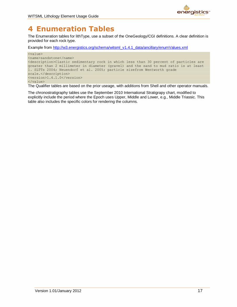
4 Enumeration Tables The Enumeration tables for lithType, use a subset of the OneGeology/CGI definitions. A clear definition is provided for each rock type.
Example from http://w3.energistics.org/schema/witsml_v1.4.1_data/ancillary/enumValues.xml
<value>
<name>sandstone</name>
<description>Clastic sedimentary rock in which less than 30 percent of particles are
greater than 2 millimeter in diameter (gravel) and the sand to mud ratio is at least
1. SLTTs 2004; Neuendorf et al. 2005; particle sizefrom Wentworth grade
scale.</description>
<version>1.4.1.0</version>
</value>
The Qualifier tables are based on the prior useage, with additions from Shell and other operator manuals.
The chronostratigraphy tables use the September 2010 International Stratigrapy chart, modified to explicitly include the period where the Epoch uses Upper, Middle and Lower, e.g., Middle Triassic. This table also includes the specific colors for rendering the columns.
WITSML Lithology Element Usage Guide
Version 1.01/January 2012 18
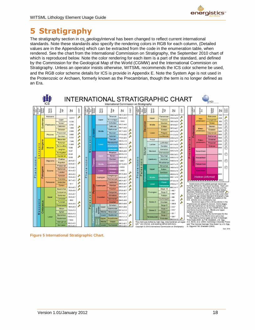
5 Stratigraphy The stratigraphy section in cs_geologyInterval has been changed to reflect current international standards. Note these standards also specify the rendering colors in RGB for each column, (Detailed values are in the Appendices) which can be extracted from the code in the enumeration table, when rendered. See the chart from the International Commission on Stratigraphy, the September 2010 chart of which is reproduced below. Note the color rendering for each item is a part of the standard, and defined by the Commission for the Geological Map of the World (CGMW) and the International Commision on Stratigraphy. Unless an operator insists otherwise, WITSML recommends the ICS color scheme be used,
and the RGB color scheme details for ICS is provide in Appendix E. Note the System Age is not used in
the Proterozoic or Archaen, formerly known as the Precambrian, though the term is no longer defined as an Era.
Figure 5 International Stratigraphic Chart.
WITSML Lithology Element Usage Guide
Version 1.01/January 2012 19
Appendix A. References
The International Commission on Stratigraphy. http://www.stratigraphy.org
The 1995 Shell Standard Legend. http://w3.energistics.org/Shell_Standard_Legend/STANDLEG.PDF
OneGeology www.onegeology.org
The Commission for the Management and Application of Geoscience Information is a Commission of the International Union of Geological Sciences. http://www.cgi-iugs.org/
WITSML Lithology Element Usage Guide
Version 1.01/January 2012 20
Appendix B. Changes between 1.3 and 1.4.1
The scope for the 1.4.1 update was to minimize the changes to the schema, but to improve the documentation and enumeration.
B.1 Key Changes Remove duplication in the enumeration. The geological definitions for both Salt and Halite were
identical in the enumeration tables, as one example.
Clarify the documentation to ensure consistent definitions. Where possible, definitions that are generic that can be used to derive operator specific detail, it is recommended the secondary detail be excluded. Examples include the ad hoc use of codeLith as mnemonic for lithology mnemonics, for which differing operators use different styles, and both a percentage and a textual term for abundance, where differing operators use different terms for abundance. The recommended approach is to allow the rendering application at the client to provide the detail, thus for example, allowing the client program to determine from a lookup table local to the client if SST, or SS is the preferred end user mnemonic for “Sandstone”.
Correct geological errors. Quartzite was defined as a sedimentary rock in earlier enumeration tables. Dunham/Embry & Klovan classification was in places referred to as “Durham”.
Remove duplication in the schemas. Examples included duplication of Shale Density placeholders in both cs_lithology and cs_geologyInterval, identical definitions were in use for nameFormation and lithostratigraphic.
Clarify the documentation to ensure consistent usage, and suggest which items should not be used. Ensure the user understands the choice between either a free text description, or a structured description, but to use both would create ambiguity. In cs_qualifier in 1.3.1 both percentage abundance and a specific code for that percentage was defined. However different operators use different terms for a 10% abundance of a qualifier, so defining abundanceCode imposes an unneeded constraint and is unnecessary duplication. The end visualization application can determine if for that end user they wish to display 10%, or map that % to a local, specific term such as “Trace” or “Common”.
Apply standard international nomenclature for chronostratigraphy, and detail the hierarchy at which lithostratigraphy should be expressed.
B.2 Affected Schemas in the Change to 1.4.1 cs_lithology
cs_qualifier
cs_geologyInterval
WITSML Lithology Element Usage Guide
Version 1.01/January 2012 21
Appendix C. Lithology Descriptions
A subset of these terms appropriate for use in the sedimentary basins of hydrocarbon exploitation has been selected, with a limited scope for igneous and metamorphic terms appropriate to the identification by available analytical techniques at the rig site on cuttings. The sedimentary definitions are principally those of Hallsworth and Knox of the BGS, though Hallsworth and Knox, (and hence some major UK Operators) decided not to include the term Shale in the definitions. OneGeology includes the term Shale, with the U.S. definition, but limits itself solely to fabric descriptions appropriate for field use.
As used in OneGeology Europe, a wellsite observation is largely a fabric description of the lithology, and typically insufficient detail, time or technology is available with drill cuttings to make the depositional environment inferences of classification systems such as Dunham or the modified Dunham terms in common usage from laboratory analysis of slabbed core. However, as per the GeoSciML CGI structure, these terms are included in the options in the enumeration list, to allow the same structure to be utilized for lab techniques if required. However for the Lithology Column, all the Dunham detail will simply be plotted as “Limestone” and so the use of the Dunham terms of the enumeration table should be used with caution at the wellsite.
When in time WITSML is used more in Geothermal Logging or in the mineral boreholes currently using the XMML of the exploration mining industry, then the enumeration table can be expanded to include the full range of CGI igneous and metamorphic definitions, though other changes in WITSML are also needed for these wellsite operations, to include unique measurements in those drilling operations.
WITSML Lithology Element Usage Guide
Version 1.01/January 2012 22
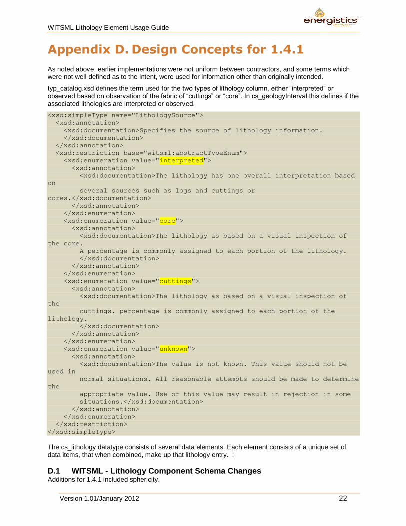
Appendix D. Design Concepts for 1.4.1
As noted above, earlier implementations were not uniform between contractors, and some terms which were not well defined as to the intent, were used for information other than originally intended.
typ_catalog.xsd defines the term used for the two types of lithology column, either “interpreted” or observed based on observation of the fabric of “cuttings” or “core”. In cs_geologyInterval this defines if the associated lithologies are interpreted or observed.
<xsd:simpleType name="LithologySource">
<xsd:annotation>
<xsd:documentation>Specifies the source of lithology information.
</xsd:documentation>
</xsd:annotation>
<xsd:restriction base="witsml:abstractTypeEnum">
<xsd:enumeration value="interpreted">
<xsd:annotation>
<xsd:documentation>The lithology has one overall interpretation based
on
several sources such as logs and cuttings or
cores.</xsd:documentation>
</xsd:annotation>
</xsd:enumeration>
<xsd:enumeration value="core">
<xsd:annotation>
<xsd:documentation>The lithology as based on a visual inspection of
the core.
A percentage is commonly assigned to each portion of the lithology.
</xsd:documentation>
</xsd:annotation>
</xsd:enumeration>
<xsd:enumeration value="cuttings">
<xsd:annotation>
<xsd:documentation>The lithology as based on a visual inspection of
the
cuttings. percentage is commonly assigned to each portion of the
lithology.
</xsd:documentation>
</xsd:annotation>
</xsd:enumeration>
<xsd:enumeration value="unknown">
<xsd:annotation>
<xsd:documentation>The value is not known. This value should not be
used in
normal situations. All reasonable attempts should be made to determine
the
appropriate value. Use of this value may result in rejection in some
situations.</xsd:documentation>
</xsd:annotation>
</xsd:enumeration>
</xsd:restriction>
</xsd:simpleType>
The cs_lithology datatype consists of several data elements. Each element consists of a unique set of data items, that when combined, make up that lithology entry. :
D.1 WITSML - Lithology Component Schema Changes Additions for 1.4.1 included sphericity.
WITSML Lithology Element Usage Guide
Version 1.01/January 2012 23
The following were deprecated:
shaleDensity – This is also in cs_geologyInterval where it is more appropriate, along with other manual physical measurements on the samples, such as bulk density.
lithClass – In the past this was intended to distinguish between alternative classification schemes such as Dunham or Folk. This is no longer necessary with the Dunham classifications included in Lithology Type
grainType – Duplicated definition with sizeGrain.
dunhamClass - It was not clear how this was intended to be used with lithClass. The Dunham classes are included in the Lithology Types.
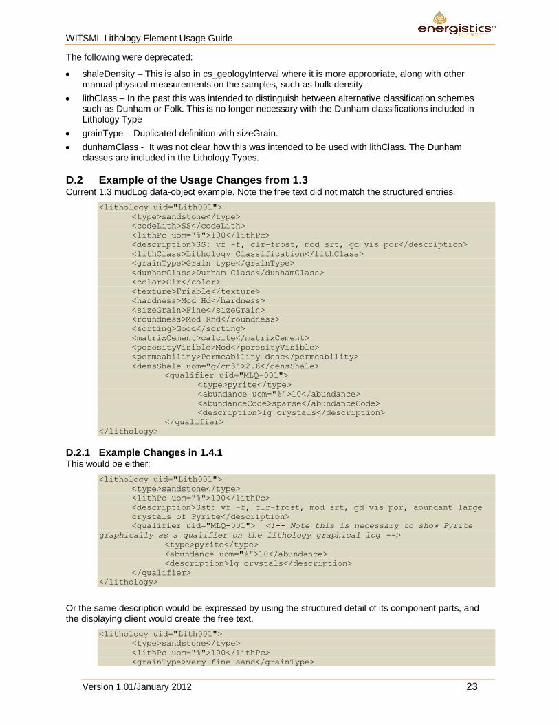
D.2 Example of the Usage Changes from 1.3 Current 1.3 mudLog data-object example. Note the free text did not match the structured entries.
<lithology uid="Lith001">
<type>sandstone</type>
<codeLith>SS</codeLith>
<lithPc uom="%">100</lithPc>
<description>SS: vf -f, clr-frost, mod srt, gd vis por</description>
<lithClass>Lithology Classification</lithClass>
<grainType>Grain type</grainType>
<dunhamClass>Durham Class</dunhamClass>
<color>Cir</color>
<texture>Friable</texture>
<hardness>Mod Hd</hardness>
<sizeGrain>Fine</sizeGrain>
<roundness>Mod Rnd</roundness>
<sorting>Good</sorting>
<matrixCement>calcite</matrixCement>
<porosityVisible>Mod</porosityVisible>
<permeability>Permeability desc</permeability>
<densShale uom="g/cm3">2.6</densShale>
<qualifier uid="MLQ-001">
<type>pyrite</type>
<abundance uom="%">10</abundance>
<abundanceCode>sparse</abundanceCode>
<description>lg crystals</description>
</qualifier>
</lithology>
D.2.1 Example Changes in 1.4.1 This would be either:
<lithology uid="Lith001">
<type>sandstone</type>
<lithPc uom="%">100</lithPc>
<description>Sst: vf -f, clr-frost, mod srt, gd vis por, abundant large
crystals of Pyrite</description>
<qualifier uid="MLQ-001"> <!-- Note this is necessary to show Pyrite
graphically as a qualifier on the lithology graphical log -->
<type>pyrite</type>
<abundance uom="%">10</abundance>
<description>lg crystals</description>
</qualifier>
</lithology>
Or the same description would be expressed by using the structured detail of its component parts, and the displaying client would create the free text.
<lithology uid="Lith001">
<type>sandstone</type>
<lithPc uom="%">100</lithPc>
<grainType>very fine sand</grainType>
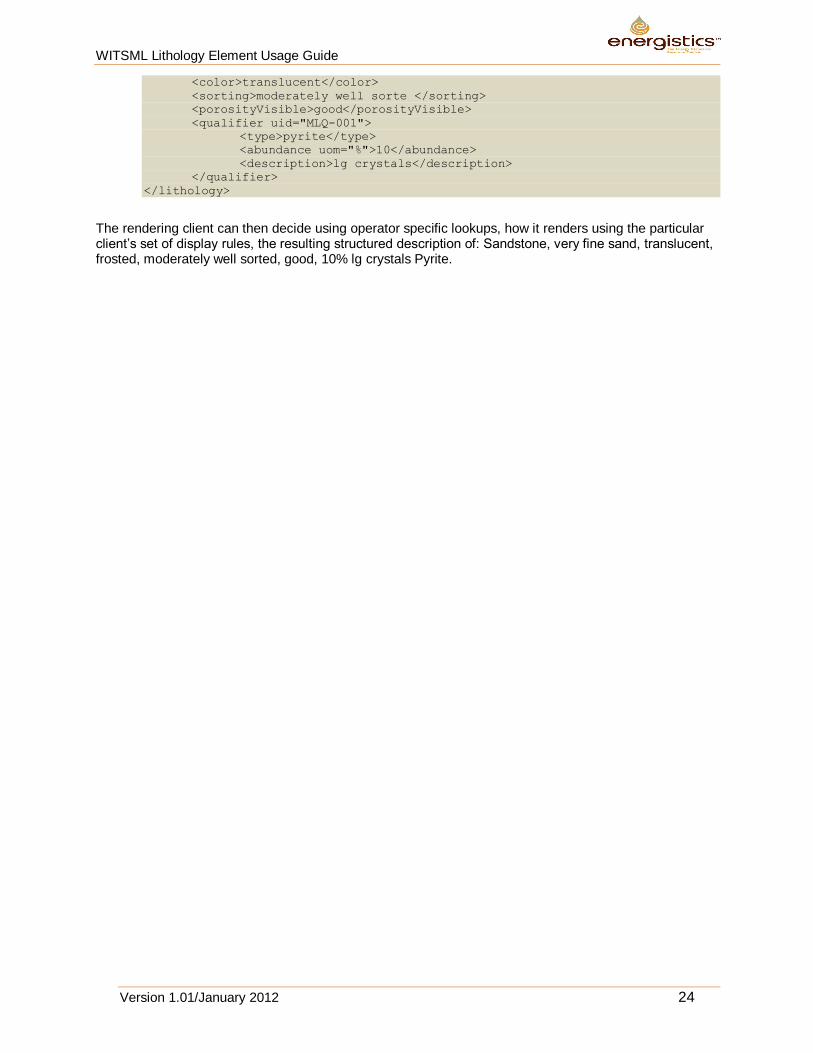
WITSML Lithology Element Usage Guide
Version 1.01/January 2012 24
<color>translucent</color>
<sorting>moderately well sorte </sorting>
<porosityVisible>good</porosityVisible>
<qualifier uid="MLQ-001">
<type>pyrite</type>
<abundance uom="%">10</abundance>
<description>lg crystals</description>
</qualifier>
</lithology>
The rendering client can then decide using operator specific lookups, how it renders using the particular client’s set of display rules, the resulting structured description of: Sandstone, very fine sand, translucent, frosted, moderately well sorted, good, 10% lg crystals Pyrite.
WITSML Lithology Element Usage Guide
Version 1.01/January 2012 25
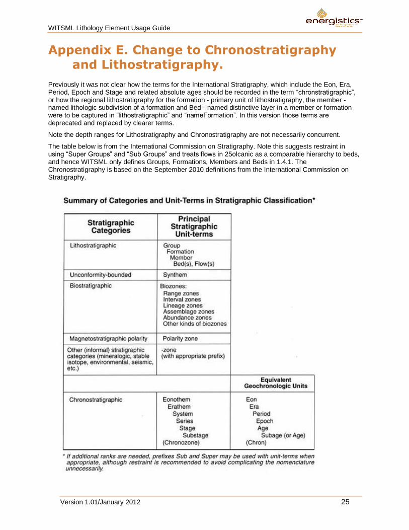
Appendix E. Change to Chronostratigraphy and Lithostratigraphy.
Previously it was not clear how the terms for the International Stratigraphy, which include the Eon, Era, Period, Epoch and Stage and related absolute ages should be recorded in the term “chronstratigraphic”, or how the regional lithostratigraphy for the formation - primary unit of lithostratigraphy, the member - named lithologic subdivision of a formation and Bed - named distinctive layer in a member or formation were to be captured in “lithostratigraphic” and “nameFormation”. In this version those terms are deprecated and replaced by clearer terms.
Note the depth ranges for Lithostratigraphy and Chronostratigraphy are not necessarily concurrent.
The table below is from the International Commission on Stratigraphy. Note this suggests restraint in using “Super Groups” and “Sub Groups” and treats flows in 25olcanic as a comparable hierarchy to beds, and hence WITSML only defines Groups, Formations, Members and Beds in 1.4.1. The Chronostratigraphy is based on the September 2010 definitions from the International Commission on Stratigraphy.
WITSML Lithology Element Usage Guide
Version 1.01/January 2012 26
In cs_geologyInterval, element “nameFormation” now has the following description:
DEPRECATED. Formerly defined as name of formation penetrated,
now deprecated to be replaced by standard lithostratigraphic term with
kind="formation".
The types of elements lithostratigraphic and chronostratigraphic were changed to utilize a structure allows the capture of the hierarchy to which they apply.
<xsd:element name="lithostratigraphic" type="witsml:lithostratigraphyStruct"
...>
<xsd:element name="chronostratigraphic" type="witsml:chronostratigraphyStruct"
...">
Type lithostratigraphyStruct was added to typ_dataTypes and has the following description:
The name of a lithostratigraphy, with the "kind" attribute specifying the
lithostratigraphic unit-hierarchy (Group, Formation, Member or Bed).The entry
at each level is free text for the local lithostratigraphy at that level in
the hierarchy.
If a single hierarchy is defined, it is assumed this is at the Formation level
in the hierarchy and kind=formation should be used for the entry.
While type chronostratigraphyStruct has the following description:
The name of a chronostratigraphy, with the "kind" attribute specifying the
chronostratigraphic unit-hierarchy (Era, Period, Epoch, Stage
In the future we might wish to add Supergroups to the lithostratigraphy, and as noted in future suggested changes the chosen chronstratigraphy titles were a mix of the chronostratigraphy terms and geochronology terms which should be corrected in future versions. The code should reflect lower case for kind. Chronostratigraphy should use the terminology of the September 2010 version of the ICS chart, and the ICS color scheme if color filled, rather than the CGMW colors.(Attached to the back of this document.)
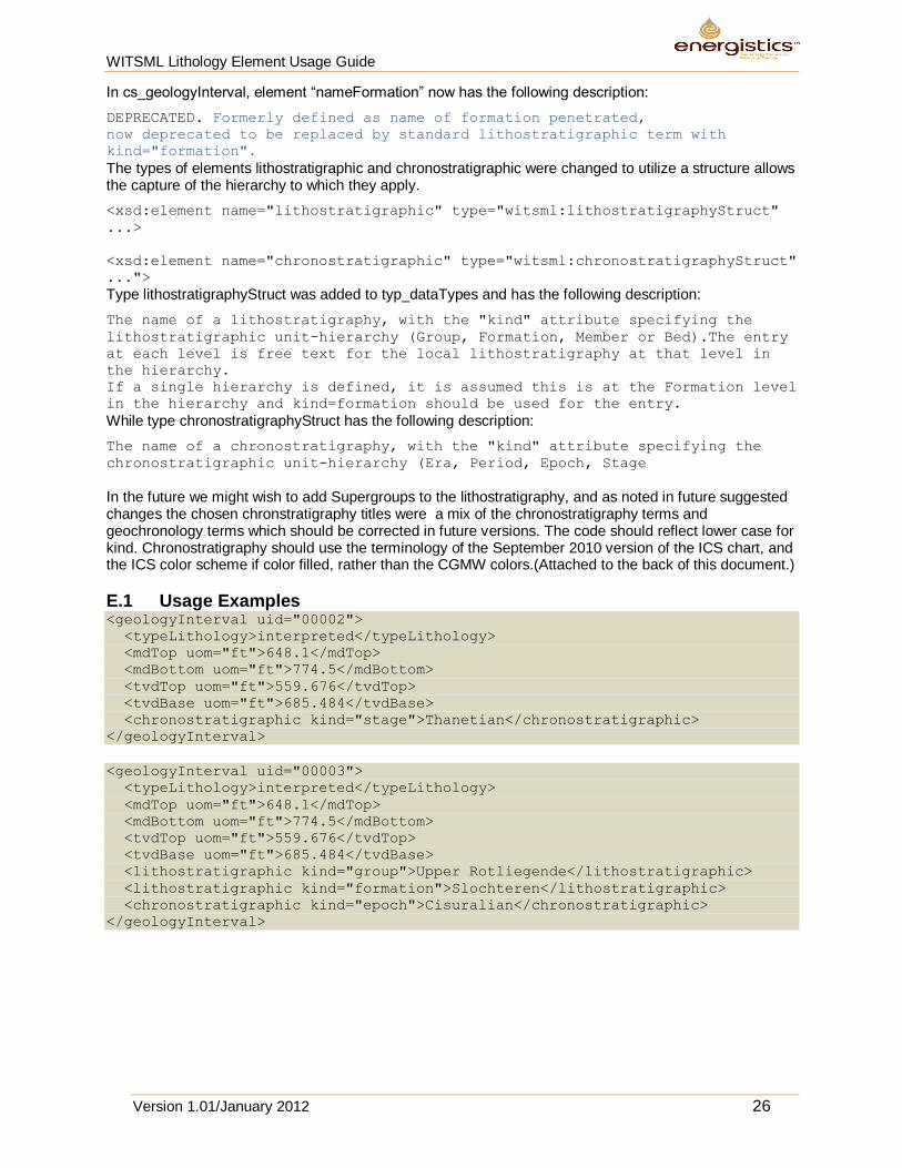
E.1 Usage Examples <geologyInterval uid="00002">
<typeLithology>interpreted</typeLithology>
<mdTop uom="ft">648.1</mdTop>
<mdBottom uom="ft">774.5</mdBottom>
<tvdTop uom="ft">559.676</tvdTop>
<tvdBase uom="ft">685.484</tvdBase>
<chronostratigraphic kind="stage">Thanetian</chronostratigraphic>
</geologyInterval>
<geologyInterval uid="00003">
<typeLithology>interpreted</typeLithology>
<mdTop uom="ft">648.1</mdTop>
<mdBottom uom="ft">774.5</mdBottom>
<tvdTop uom="ft">559.676</tvdTop>
<tvdBase uom="ft">685.484</tvdBase>
<lithostratigraphic kind="group">Upper Rotliegende</lithostratigraphic>
<lithostratigraphic kind="formation">Slochteren</lithostratigraphic>
<chronostratigraphic kind="epoch">Cisuralian</chronostratigraphic>
</geologyInterval>
WITSML Lithology Element Usage Guide
Version 1.01/January 2012 27
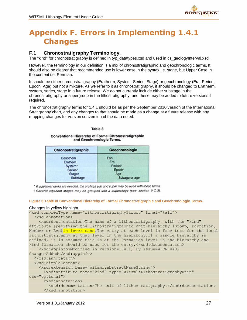
Appendix F. Errors in Implementing 1.4.1 Changes
F.1 Chronostratigraphy Terminology. The "kind" for chronostratigraphy is defined in typ_datatypes.xsd and used in cs_geologyInterval.xsd.
However, the terminology in our definition is a mix of chronostratigraphic and geochronologic terms. It should also be clearer that recommended use is lower case in the syntax i.e. stage, but Upper Case in the content i.e. Permian.
It should be either chronostratigraphy (Eratherm, System, Series, Stage) or geochronology (Era, Period, Epoch, Age) but not a mixture. As we refer to it as chronostratigraphy, it should be changed to Eratherm, system, series, stage in a future release. We do not currently include either substage in the chronostratigraphy or supergroup in the lithostratigraphy, and these may be added to future versions if required.
The chronostratigraphy terms for 1.4.1 should be as per the September 2010 version of the International Stratigraphy chart, and any changes to that should be made as a change at a future release with any mapping changes for version conversion of the data noted.
Figure 6 Table of Conventional Hierarchy of Formal Chronostratigraphic and Geochronologic Terms.
Changes in yellow highlight. <xsd:complexType name="lithostratigraphyStruct" final="#all">
<xsd:annotation>
<xsd:documentation>The name of a lithostratigraphy, with the "kind"
attribute specifying the lithostratigraphic unit-hierarchy (Group, Formation,
Member or Bed)in lower case.The entry at each level is free text for the local
lithostratigraphy at that level in the hierarchy.If a single hierarchy is
defined, it is assumed this is at the Formation level in the hierarchy and
kind=formation should be used for the entry.</xsd:documentation>
<xsd:appinfo>Modified-in-version=1.4.1, By-issue=W-CR-043,
Change=Added</xsd:appinfo>
</xsd:annotation>
<xsd:simpleContent>
<xsd:extension base="witsml:abstractNameString">
<xsd:attribute name="kind" type="witsml:LithostratigraphyUnit"
use="optional">
<xsd:annotation>
<xsd:documentation>The unit of lithostratigraphy.</xsd:documentation>
</xsd:annotation>
WITSML Lithology Element Usage Guide
Version 1.01/January 2012 28
</xsd:attribute>
</xsd:extension>
</xsd:simpleContent>
</xsd:complexType>
<!--
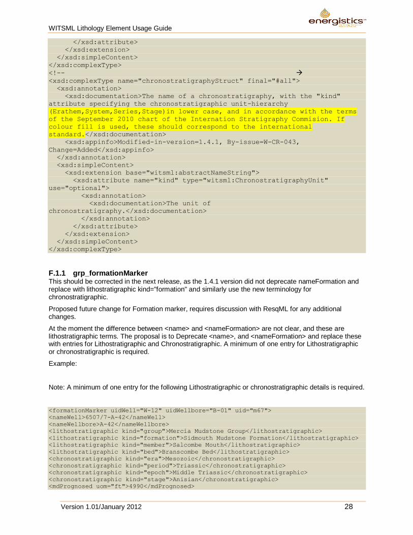
<xsd:complexType name="chronostratigraphyStruct" final="#all">
<xsd:annotation>
<xsd:documentation>The name of a chronostratigraphy, with the "kind"
attribute specifying the chronostratigraphic unit-hierarchy
(Erathem,System,Series,Stage)in lower case, and in accordance with the terms
of the September 2010 chart of the Internation Stratigraphy Commision. If
colour fill is used, these should correspond to the international
standard.</xsd:documentation>
<xsd:appinfo>Modified-in-version=1.4.1, By-issue=W-CR-043,
Change=Added</xsd:appinfo>
</xsd:annotation>
<xsd:simpleContent>
<xsd:extension base="witsml:abstractNameString">
<xsd:attribute name="kind" type="witsml:ChronostratigraphyUnit"
use="optional">
<xsd:annotation>
<xsd:documentation>The unit of
chronostratigraphy.</xsd:documentation>
</xsd:annotation>
</xsd:attribute>
</xsd:extension>
</xsd:simpleContent>
</xsd:complexType>
F.1.1 grp_formationMarker This should be corrected in the next release, as the 1.4.1 version did not deprecate nameFormation and replace with lithostratigraphic kind="formation" and similarly use the new terminology for chronostratigraphic.
Proposed future change for Formation marker, requires discussion with ResqML for any additional changes.
At the moment the difference between <name> and <nameFormation> are not clear, and these are lithostratigraphic terms. The proposal is to Deprecate <name>, and <nameFormation> and replace these with entries for Lithostratigraphic and Chronostratigraphic. A minimum of one entry for Lithostratigraphic or chronostratigraphic is required.
Example:
Note: A minimum of one entry for the following Lithostratigraphic or chronostratigraphic details is required.
<formationMarker uidWell="W-12" uidWellbore="B-01" uid="m67">
<nameWell>6507/7-A-42</nameWell>
<nameWellbore>A-42</nameWellbore>
<lithostratigraphic kind="group">Mercia Mudstone Group</lithostratigraphic>
<lithostratigraphic kind="formation">Sidmouth Mudstone Formation</lithostratigraphic>
<lithostratigraphic kind="member">Salcombe Mouth</lithostratigraphic>
<lithostratigraphic kind="bed">Branscombe Bed</lithostratigraphic>
<chronostratigraphic kind="era">Mesozoic</chronostratigraphic>
<chronostratigraphic kind="period">Triassic</chronostratigraphic>
<chronostratigraphic kind="epoch">Middle Triassic</chronostratigraphic>
<chronostratigraphic kind="stage">Anisian</chronostratigraphic>
<mdPrognosed uom="ft">4990</mdPrognosed>
WITSML Lithology Element Usage Guide
Version 1.01/January 2012 29
<tvdPrognosed uom="ft">4685</tvdPrognosed>
<mdTopSample uom="ft">5000</mdTopSample>
<tvdTopSample uom="ft">4695</tvdTopSample>
<thicknessBed uom="ft">200</thicknessBed>
<thicknessApparent uom="ft">260</thicknessApparent>
<thicknessPerpen uom="ft">185</thicknessPerpen>
<mdLogSample uom="ft">4997</mdLogSample>
<tvdLogSample uom="ft">4692</tvdLogSample>
<dip uom="dega">10</dip>
<dipDirection uom="dega">200</dipDirection>
<description>Top Reservior</description>
<commonData>
<itemState>actual</itemState>
<comments>Waiting on wireline GR to confirm pick</comments>
</commonData>
</formationMarker>
F.1.2 Multiple Different Text Strings for Lithology Description A free text entry for lithology descriptions occurs in multiple places with differing syntax. These should be amended to be consistent, especially as some are comment strings and others description strings.
Cs_lithology
<xsd:element name="description" type="witsml:commentString" minOccurs="0"
maxOccurs="1">
<xsd:annotation>
<xsd:documentation>Free text sample description of item and details, using a
structured approach as per AAPG and Shell style, or specific operator descriptive
hierarchy typically in the order of Rock Type, Qualifier,colour, Texture, Cement
matrix type, compaction, Fracture, accessories, fossils, structure porosity, Shows.
This should be blank if a structured approach to creating the description is used.
Example clastic descriptions:SST, qtz, wh lt gy grn, m – c g, well sort, subrnd-
subang, sub sph – sph, grst tex, wk calc cmt,fria, glauc rr mica, gd vis por, patchy
dk brn oil stn, wk yel dir fluor, bri yel cut fluor, instant blooming yel-wh crush cut
fluor, dk brn cut col.
Example carbonate description: LST; wh buff lt brn, m-c g, bioclastic grst, xln cmt,
hd, ang brk, tr pyr, poor vis por.</xsd:documentation>
</xsd:annotation>
...
cs_drillReportLithShowInfo
<xsd:element name="lithology" type="witsml:descriptionString" minOccurs="0"
maxOccurs="1">
<xsd:annotation>
<xsd:documentation>A description that gives a geological/lithological
description/evaluation of the interval.</xsd:documentation>
</xsd:annotation>
...
cs_drillReportStratInfo (Is this also not synonymous with formationMarker ? The need for this should be evaluated, as it does not include any stratigraphy items.)
<xsd:element name="description" type="witsml:descriptionString" minOccurs="0"
maxOccurs="1">
<xsd:annotation>
<xsd:documentation>A lithological description of the geological formation at the
given depth.</xsd:documentation>
</xsd:annotation>
...
Lithology
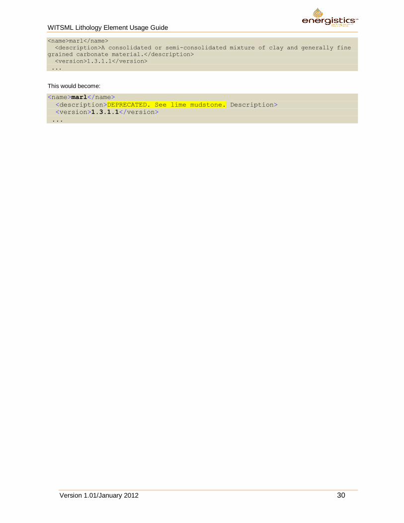
Some of the 1.3.1.1 terms that are not part of the OneGeology set were not deprecated.
Example:
WITSML Lithology Element Usage Guide
Version 1.01/January 2012 30
<name>marl</name>
<description>A consolidated or semi-consolidated mixture of clay and generally fine
grained carbonate material.</description>
<version>1.3.1.1</version>
...
This would become:
<name>marl</name>
<description>DEPRECATED. See lime mudstone. Description>
<version>1.3.1.1</version>
...
WITSML Lithology Element Usage Guide
Version 1.01/January 2012 31
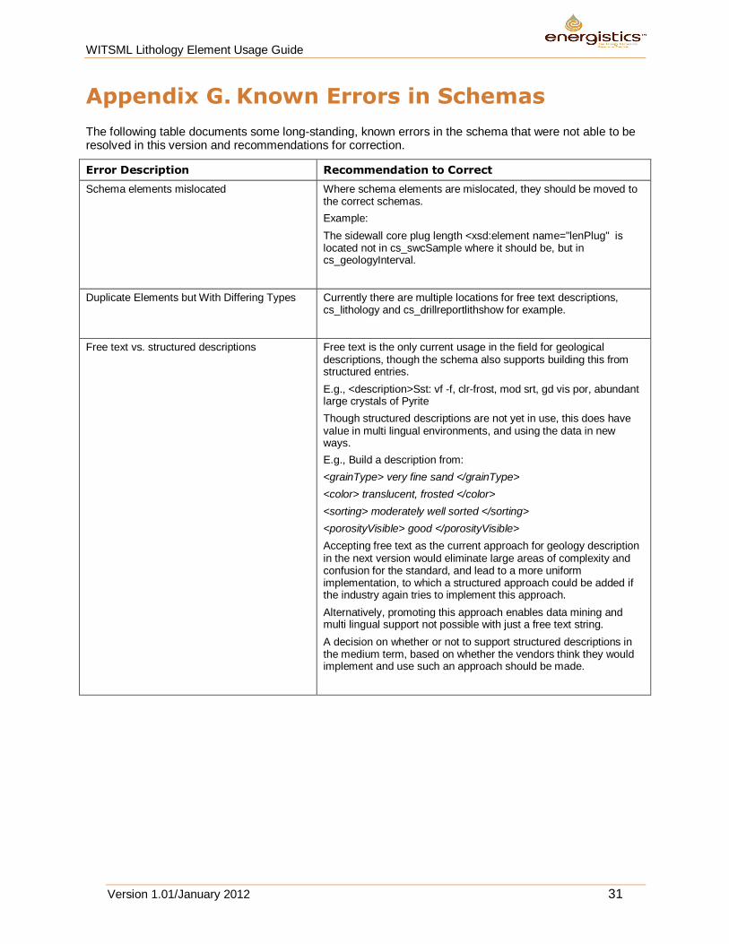
Appendix G. Known Errors in Schemas
The following table documents some long-standing, known errors in the schema that were not able to be resolved in this version and recommendations for correction.
Error Description Recommendation to Correct
Schema elements mislocated Where schema elements are mislocated, they should be moved to the correct schemas.
Example:
The sidewall core plug length <xsd:element name="lenPlug" is located not in cs_swcSample where it should be, but in cs_geologyInterval.
Duplicate Elements but With Differing Types Currently there are multiple locations for free text descriptions, cs_lithology and cs_drillreportlithshow for example.
Free text vs. structured descriptions Free text is the only current usage in the field for geological descriptions, though the schema also supports building this from structured entries.
E.g., <description>Sst: vf -f, clr-frost, mod srt, gd vis por, abundant large crystals of Pyrite
Though structured descriptions are not yet in use, this does have value in multi lingual environments, and using the data in new ways.
E.g., Build a description from:
<grainType> very fine sand </grainType>
<color> translucent, frosted </color>
<sorting> moderately well sorted </sorting>
<porosityVisible> good </porosityVisible>
Accepting free text as the current approach for geology description in the next version would eliminate large areas of complexity and confusion for the standard, and lead to a more uniform implementation, to which a structured approach could be added if the industry again tries to implement this approach.
Alternatively, promoting this approach enables data mining and multi lingual support not possible with just a free text string.
A decision on whether or not to support structured descriptions in the medium term, based on whether the vendors think they would implement and use such an approach should be made.
WITSML Lithology Element Usage Guide
Version 1.01/January 2012 32
Appendix H. Suggested Changes to Other Schemas.
To enable correct lithology usage, and do all that is necessary for a wellsite composite log, changes were made to correct errors in the usage of lithostratigraphy and chronostratigraphy in cs_geologyInterval, cs_lithology and cs_qualifier.
The following errors and omissions were also noted, but not addressed as not in scope of the lithology team. They should however be addressed in the near future.
Correct inconsistencies between free text and structured format data. Currently cs_show implies only a structured format for a show description, but the cs_drillReportLithShowInfo implies only a free text show description. It would seem logical to change these to be the same as used in lithology, i.e. have either a free text string, or a structured well defined model, but not both in separate parts of the standard. This change requires better definition of the show terms, and changes to cs_drillReportLithShowInfo to point to an improved cs_show that includes the free text option, which is likely to be used in the short term until the structured approach has the user interface implemented in the data entry applications for wellsite use.
E.g. cs_drillReportLithShowInfo element below “show” does not appear in cs_show. In future cs_drillReportLithShow should reference cs_show, and cs_show should have the option of either a free text field or structured data entry.
<xsd:element name="show" type="witsml:descriptionString" minOccurs="0"
maxOccurs="1">
<xsd:annotation>
<xsd:documentation>A textual description of any shows in the interval.
</xsd:documentation>
</xsd:annotation>
A quick fix for 1.4.1 would be to add the above to cs_show as an alternate to a structured entry, or suggest in the short term the free text in cs_lithology also be used for show descriptions.
Similar comments apply to cs_drillReportStratInfo where description should reference the description in cs_lithology.
<xsd:element name="description" type="witsml:descriptionString" minOccurs="0"
maxOccurs="1">
<xsd:annotation>
<xsd:documentation>A lithological description of the geological formation at
the given depth.</xsd:documentation>
</xsd:annotation>
</xsd:element>
Relocate items to the correct locations.
The sidewall core plug length <xsd:element name="lenPlug" is located not in cs_swcSample where it should be, but in cs_geologyInterval.
The cut liquid definition <xsd:element name="cuttingFluid" is not in the show schema, but in cs_geologyInterval. There is a strong case it should be in cs_show.
There are many terms in cs_geologyInterval that are still not clear as to the intended usage.
Be consistent in usage. cs_drillReportStratInfo uses "witsml:descriptionString" for its free text description, where cs_lithology uses “witsml:commentString” however it should be possible to reference the appropriate string from cs_lithology, so it makes no sense that these are differing data types. In future cs_drillReportStratInfo should have the option to use the structured format of cs_lithology.
WITSML Lithology Element Usage Guide
Version 1.01/January 2012 33
Appendix I. Other Lithology Standards
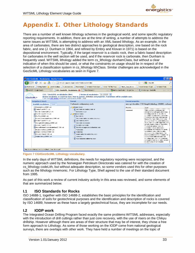
There are a number of well known lithology schemes in the geological world, and some specific regulatory reporting requirements. In addition, there are at the time of writing, a number of attempts to address the same issues as WITSML is attempting to address with an XML-based lithology. As an example, in the area of carbonates, there are two distinct approaches to geological description, one based on the rock fabric, and one (J. Dunham in 1964, and refined by Embry and Klovan in 1971) is based on the depositional environment. Typically, if the target reservoir is a clastic rock, then a fabric based description for carbonates in the well section will be used, and if the reservoir rock is carbonate, then Dunham is frequently used. WITSML lithology added the term cs_lithology dunhamClass, but without a clear indication of when this should be used, or what the constraints on usage should be in respect of the selection of a classification system in cs_lithology lithClass. Similar challenges are acknowledged in the GeoSciML Lithology vocabularies as seen in Figure 7.
Figure 7 CGI/GeoSciML Lithology vocabulary.
In the early days of WITSML definitions, the needs for regulatory reporting were recognized, and the numeric approach used by the Norwegian Petroleum Directorate was catered for with the creation of cs_lithology codeLith, but without adequate description, so some vendors used this for other purposes such as the lithology mnemonic. For Lithology Type, Shell agreed to the use of their standard document from 1995.
As part of this work a review of current industry activity in this area was reviewed, and some elements of that are summarized below.
I.1 ISO Standards for Rocks ISO 14688-1, together with ISO 14688-2, establishes the basic principles for the identification and classification of soils for geotechnical purposes and the identification and description of rocks is covered by ISO 14689, however as these have a largely geotechnical focus, they are incomplete for our needs.
I.2 IODP work The Integrated Ocean Drilling Program faced exactly the same problems WITSML addresses, especially with the introduction of drill cuttings rather than just core recovery, with the use of risers on the Chikyu drillship. However although there are areas of their structure that may be of interest, they chose a free form approach to Lithology. As some of those working on the IODP come from national geological surveys, there are overlaps with other work. They have held a number of meetings on the topic of
WITSML Lithology Element Usage Guide
Version 1.01/January 2012 34
lithology standardisation, which are available on the web. The current structure of their VCD/Lithology system (Visual Core Description Lithology) used for over 220 Km of core collected to date, can be seen here http://millstone.iodp.tamu.edu/wiki/index.php/Descinfo_observables . As can be seen, the key lithology descriptor here is free text but all 1753 uses in different ODP legs are documented here. http://millstone.iodp.tamu.edu/wiki/images/3/3b/Descinfo_litho_names.xls
I.3 XMML The mining industry, driven especially by Australian research organisations developed an XML for the exploration and mining industries called XMML, (http://xmml.arrc.csiro.au/ ) though this work has now been integrated into GeoSciML. As this came out of the hard rock metal mining industry, who typically core 100% of their drill holes, this work has a number of limitations for our use.
I.4 BP/Statoil Coring Project In the 1990’s BP and Statoil collaborated on a slimhole drilling project, and that included a geological element which lead to some standards designed to digitise all the material at the rig site. This work is written up in SPE27542, and in the AAPG Bulletin; Vol/Issue: 77:9 P1661.
I.5 GeoSciML GeoSciML is a geological subset of The Geography Markup Language (GML) which is the XML grammar defined by the Open Geospatial Consortium (OGC) to express geographical features. GML has been unified into ISO 19136. GeoSciML is based on W3C, OGC and ultimately ISO international standards for data exchange over the Internet. GeoSciML is being designed under the umbrella of the IUGS Commission on the Management and Application of Geoscience Information (CGI) and its CGI CGI Interoperability Working Group. However, they are struggling to agree on a unified lithology XML, and currently support at least two distinct Lithology vocabularies, one from CGI, and the other from the work done by the organization of national geological surveys under the banner of OneGeology ( www.onegeology.org ). The CGI vocabulary is not as geologically consistent as the OneGeology vocabulary. In 1G-E lithology is described using a subset of concepts drawn from the CGI SimpleLithology vocabulary in a straightforward hierarchical order. This will increase the level of harmonisation and make the portrayal easier. The complete CGI SimpleLithology vocabulary incorporates multiple hierarchies to incorporate the different geological classification systems in use. OneGeology maps lithology concepts to the ones given in Table 1GE_Lithology.xls (CGI Vocabulary). This should be done at the highest semantic resolution possible, but it is recognized that this mapping may lead to a loss of semantic resolution in some cases. When determining the correct lithology concept to use it is the concept definition rather than the concept term which should be the primary consideration. Note that in addition to CompositionPart, information about metamorphism can be provided using MetamorphicDescription (see section 3.2.9) and information about genesis (e.g. ‘intrusion’) can be provided using GeologicEvent (see section 3.2.7).
I.6 OneGeology www.onegeology.org OneGeology is an international initiative of the geological surveys of the world. They are contributing to the vocabularies for GeosciML .Of most interest to WITSML is probably the simple vocabulary of OneGeology, which is geologically consistent, and well defined.
This 2005 document which was a precursor to OneGeology refers to WITSML as a model.
http://www.eearth.eu/dinoLks/documents/publications/eearth_bridges_geo_databases.pdf
Latest copy of vocabulary in English:
https://www.seegrid.csiro.au/subversion/CGI_CDTGVocabulary/trunk/Vocab2011html/SimpleLithology201012.html
See also the 1GE 201001 vocabulary tab at http://srvgeosciml.brgm.fr/eXist2010/brgm/client.html and a description here: http://onegeology-europe.brgm.fr/how_to201002/Expl_Notes%20WP_3_vocabulary.pdf .
A recent overview presentation here. An overview of the 2010 status is available as a powerpoint here: 2010 OneGeology Presentation.
The vocabulary in Excel spreadsheet form (OneGeology Excel Files) with the English language version of the Lithology vocabulary for the One Geology Simple Lithology. (Browseable Version of OneGeology
WITSML Lithology Element Usage Guide
Version 1.01/January 2012 35
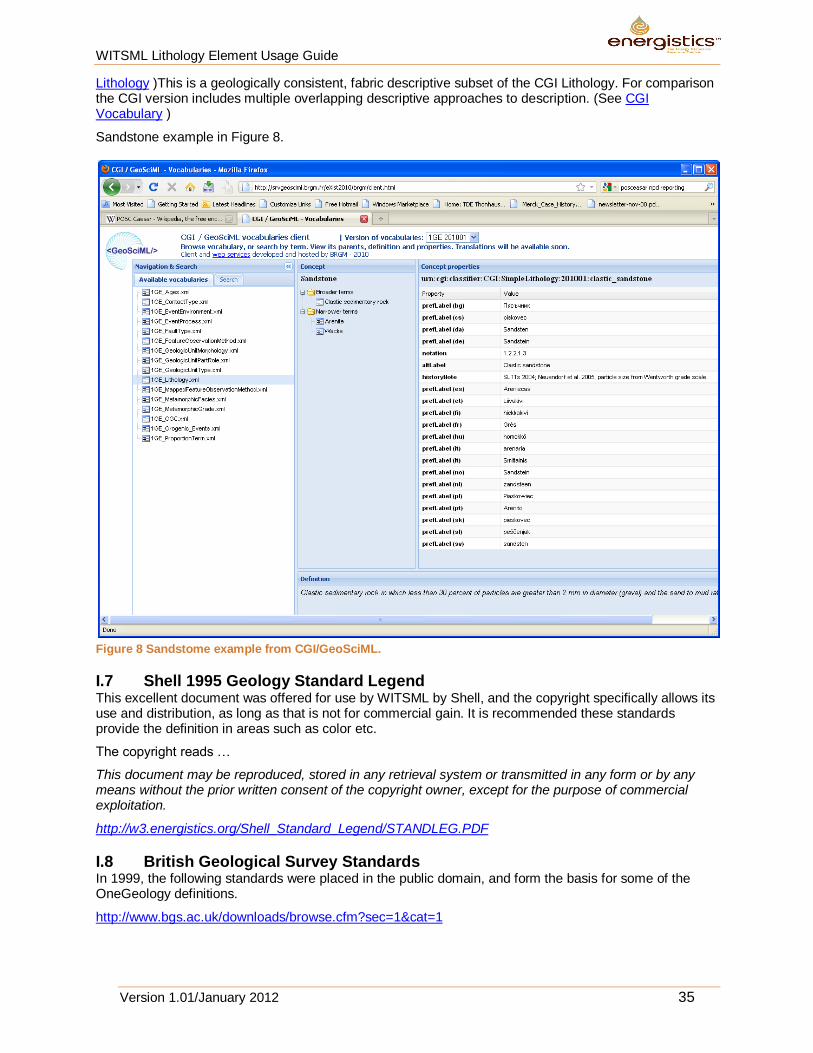
Lithology )This is a geologically consistent, fabric descriptive subset of the CGI Lithology. For comparison the CGI version includes multiple overlapping descriptive approaches to description. (See CGI Vocabulary )
Sandstone example in Figure 8.
Figure 8 Sandstome example from CGI/GeoSciML.
I.7 Shell 1995 Geology Standard Legend This excellent document was offered for use by WITSML by Shell, and the copyright specifically allows its use and distribution, as long as that is not for commercial gain. It is recommended these standards provide the definition in areas such as color etc.
The copyright reads …
This document may be reproduced, stored in any retrieval system or transmitted in any form or by any means without the prior written consent of the copyright owner, except for the purpose of commercial exploitation.
http://w3.energistics.org/Shell_Standard_Legend/STANDLEG.PDF
I.8 British Geological Survey Standards In 1999, the following standards were placed in the public domain, and form the basis for some of the OneGeology definitions.
http://www.bgs.ac.uk/downloads/browse.cfm?sec=1&cat=1
WITSML Lithology Element Usage Guide
Version 1.01/January 2012 36
I.9 United States Geological Survey Data Model The North American Geologic Map Data Model Steering Committee’s (NADM) Digital Interchange Technical Team was tasked to create an interchange format compliant with the North American Geologic Map Data Model conceptual model, known as “NADM C1”. This 2004 work was later converted into XML http://pubs.usgs.gov/of/2004/1334/2004-1334.pdf . It was realized that leveraging existing work on GML (Geographic Markup Language; OpenGis, 2004) would improve the interchange format. GML is a library that provides essential GIS features that can be reused in any geospatial application, such as NADM. GML provides reusable objects and design patterns. This work has evolved into elements of GeoSciML. Synthesis of these vocabularies into a single lithologic classification produced a vocabulary with 2027 terms. The CDTG vocabulary was assembled by a group of geologists from various countries, who discussed the kinds of lithology categories they thought should be included in a simple lithology vocabulary consisting of about 100 terms. As for the NGMDB Data Portal, the purpose of this vocabulary is data integration, not detailed scientific categorization of the full spectrum of materials found in the Earth. The initial list of terms was reduced and balanced in an attempt to include equivalent depth of detail for various families of rocks (igneous, sedimentary, metamorphic). Generalized category names had to be added in some cases where there is not a commonly used lithology term, in order to allow construction of a hierarchy of categories (e.g., composite genesis material, fault-related material). The resulting vocabulary contains 146 terms, and is available at https://www.seegrid.csiro.au/wiki/bin/view/CGIModel/ConceptDefinitionsTG
The NGMDB Data Portal lithology vocabulary has some minor differences with what has emerged as the CDTG (version 200811) vocabulary. These differences are discussed here - http://ngmdb.usgs.gov/Info/dmt/docs/DMT08_Draft_Richard1.pdf .
I.10 Norwegian Petroleum Directorate Data Standard The NPD require operators to report lithology in a well defined format, including Lithology, cements (matrixcement) and modifiers (qualifiers). These regulatory requirements for all operators on the Norwegian Shelf are defined in the NPD Blue Book digital data reporting standard for Lithology coding,
currently 2006 Version 4, Rev 2, Appendix B, 2.5.2. http://www.npd.no/Global/Norsk/5%20-%20Regelverk/Tematiske%20veiledninger/B_og_b_digital_rapportering_e.pdf .
It would be valuable to the operating companies to ensure WITSML lithology can be readily mapped to those standards using the defined tables, and that NPD through the OLF and POSC/Ceasar reporting
work are kept updated. See https://www.posccaesar.org/wiki/IIP and http://drilling.posccaesar.org/
The Daily Drilling reporting to NPD is currently undergoing a refresh to version 1.2. For details see
http://drilling.posccaesar.org/wiki/projects/DailyDrillingReport_1.2
In the development of DDR 1.2 they will not change the already included definitions of the Lithology section, as shown in Figure 9.
Figure 9 Lithology information from the NPD data standard.
This is a link to the html view of a full example report according to DDR 1.1 (dummy data):
http://drilling.posccaesar.org/svn/standards/DailyDrillingReport/1.1.0/HTMLreport/testDocumet_style5.xml
Here we provide links to the corresponding definition of an element from the POSC Caesar Association´s Reference Data Library (RDL) (according to ISO 15926), using SAWSDL annotations. I think these definitions show how the different WITSML elements used in the DDR are used. Another useful source that documents how the elements are used is the user manual provided by the Norwegian Petroleum Safety Authority:

WITSML Lithology Element Usage Guide
Version 1.01/January 2012 37
http://www.ptil.no/getfile.php/PDF/DDRS%20-%20borerapportering/DDRS-tillegg%20juni-09/WITSML_drillReport_profiled_schema_phase2_for_usermanual(1).xml
This guide also provides links to the corresponding definition from the PCA RDL (the same as in the html report and XML Schema) from their descriptions. The documentation of DDR 1.1 is available at:
http://drilling.posccaesar.org/svn/standards/DailyDrillingReport/1.1.0/
In the DDR extension work all documentation and work is done using English, and Norwegian rendering is not in scope for the current project. The next meeting in the EPIM Drilling Core groups is early May.
I.11 Mud Logging Documentation The EXLOG series of manuals originally published by IHRDC are now out of print, but available online from the original author here. www.mudloggingman.com . However for formal usage of terminology, the Shell standards represent a preferred usage.
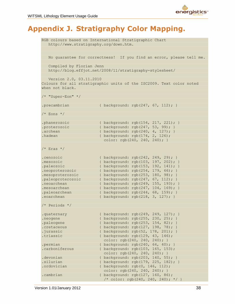
WITSML Lithology Element Usage Guide
Version 1.01/January 2012 38
Appendix J. Stratigraphy Color Mapping.
RGB colours based on International Stratigraphic Chart
http://www.stratigraphy.org/down.htm.
No guarantee for correctness! If you find an error, please tell me.
Compiled by Florian Jenn
http://blog.effjot.net/2008/11/stratigraphy-stylesheet/
Version 2.0, 03.11.2010
Colours for all stratigraphic units of the ISC2009. Text color noted
when not black.
/* "Super-Eon" */
.precambrian { background: rgb(247, 67, 112); }
/* Eons */
.phanerozoic { background: rgb(154, 217, 221); }
.proterozoic { background: rgb(247, 53, 99); }
.archean { background: rgb(240, 4, 127); }
.hadean { background: rgb(174, 2, 126);
color: rgb(240, 240, 240); }
/* Eras */
.cenozoic { background: rgb(242, 249, 29); }
.mesozoic { background: rgb(103, 197, 202); }
.paleozoic { background: rgb(153, 192, 141); }
.neoproterozoic { background: rgb(254, 179, 66); }
.mesoproterozoic { background: rgb(253, 180, 98); }
.paleoproterozoic { background: rgb(247, 67, 112); }
.neoarchean { background: rgb(249, 155, 193); }
.mesoarchean { background: rgb(247, 104, 169); }
.paleoarchean { background: rgb(244, 68, 159); }
.eoarchean { background: rgb(218, 3, 127); }
/* Periods */
.quaternary { background: rgb(249, 249, 127); }
.neogene { background: rgb(255, 230, 25); }
.paleogene { background: rgb(253, 154, 82); }
.cretaceous { background: rgb(127, 198, 78); }
.jurassic { background: rgb(52, 178, 201); }
.triassic { background: rgb(129, 43, 146);
color: rgb(240, 240, 240); }
.permian { background: rgb(240, 64, 40); }
.carboniferous { background: rgb(103, 165, 153);
color: rgb(240, 240, 240); }
.devonian { background: rgb(203, 140, 55); }
.silurian { background: rgb(179, 225, 182); }
.ordovician { background: rgb(0, 146, 112);
color: rgb(240, 240, 240); }
.cambrian { background: rgb(127, 160, 86);
/* color: rgb(240, 240, 240); */ }
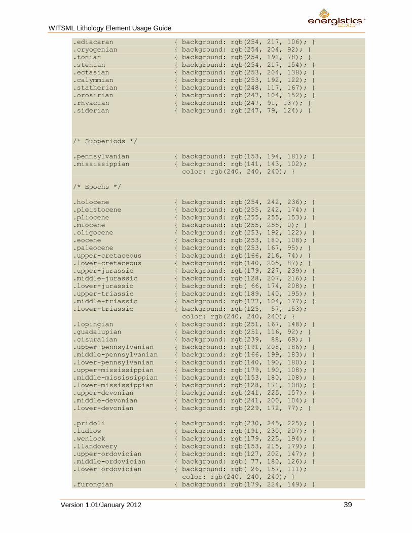
WITSML Lithology Element Usage Guide
Version 1.01/January 2012 39
.ediacaran { background: rgb(254, 217, 106); }
.cryogenian { background: rgb(254, 204, 92); }
.tonian { background: rgb(254, 191, 78); }
.stenian { background: rgb(254, 217, 154); }
.ectasian { background: rgb(253, 204, 138); }
.calymmian { background: rgb(253, 192, 122); }
.statherian { background: rgb(248, 117, 167); }
.orosirian { background: rgb(247, 104, 152); }
.rhyacian { background: rgb(247, 91, 137); }
.siderian { background: rgb(247, 79, 124); }
/* Subperiods */
.pennsylvanian { background: rgb(153, 194, 181); }
.mississippian { background: rgb(141, 143, 102);
color: rgb(240, 240, 240); }
/* Epochs */
.holocene { background: rgb(254, 242, 236); }
.pleistocene { background: rgb(255, 242, 174); }
.pliocene { background: rgb(255, 255, 153); }
.miocene { background: rgb(255, 255, 0); }
.oligocene { background: rgb(253, 192, 122); }
.eocene { background: rgb(253, 180, 108); }
.paleocene { background: rgb(253, 167, 95); }
.upper-cretaceous { background: rgb(166, 216, 74); }
.lower-cretaceous { background: rgb(140, 205, 87); }
.upper-jurassic { background: rgb(179, 227, 239); }
.middle-jurassic { background: rgb(128, 207, 216); }
.lower-jurassic { background: rgb( 66, 174, 208); }
.upper-triassic { background: rgb(189, 140, 195); }
.middle-triassic { background: rgb(177, 104, 177); }
.lower-triassic { background: rgb(125, 57, 153);
color: rgb(240, 240, 240); }
.lopingian { background: rgb(251, 167, 148); }
.guadalupian { background: rgb(251, 116, 92); }
.cisuralian { background: rgb(239, 88, 69); }
.upper-pennsylvanian { background: rgb(191, 208, 186); }
.middle-pennsylvanian { background: rgb(166, 199, 183); }
.lower-pennsylvanian { background: rgb(140, 190, 180); }
.upper-mississippian { background: rgb(179, 190, 108); }
.middle-mississippian { background: rgb(153, 180, 108); }
.lower-mississippian { background: rgb(128, 171, 108); }
.upper-devonian { background: rgb(241, 225, 157); }
.middle-devonian { background: rgb(241, 200, 104); }
.lower-devonian { background: rgb(229, 172, 77); }
.pridoli { background: rgb(230, 245, 225); }
.ludlow { background: rgb(191, 230, 207); }
.wenlock { background: rgb(179, 225, 194); }
.llandovery { background: rgb(153, 215, 179); }
.upper-ordovician { background: rgb(127, 202, 147); }
.middle-ordovician { background: rgb( 77, 180, 126); }
.lower-ordovician { background: rgb( 26, 157, 111);
color: rgb(240, 240, 240); }
.furongian { background: rgb(179, 224, 149); }
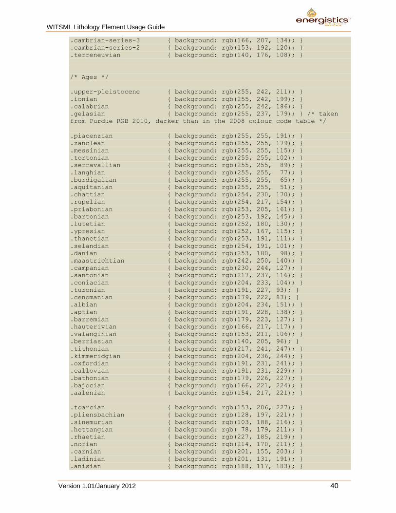
WITSML Lithology Element Usage Guide
Version 1.01/January 2012 40
.cambrian-series-3 { background: rgb(166, 207, 134); }
.cambrian-series-2 { background: rgb(153, 192, 120); }
.terreneuvian { background: rgb(140, 176, 108); }
/* Ages */
.upper-pleistocene { background: rgb(255, 242, 211); }
.ionian { background: rgb(255, 242, 199); }
.calabrian { background: rgb(255, 242, 186); }
.gelasian { background: rgb(255, 237, 179); } /* taken
from Purdue RGB 2010, darker than in the 2008 colour code table */
.piacenzian { background: rgb(255, 255, 191); }
.zanclean { background: rgb(255, 255, 179); }
.messinian { background: rgb(255, 255, 115); }
.tortonian { background: rgb(255, 255, 102); }
.serravallian { background: rgb(255, 255, 89); }
.langhian { background: rgb(255, 255, 77); }
.burdigalian { background: rgb(255, 255, 65); }
.aquitanian { background: rgb(255, 255, 51); }
.chattian { background: rgb(254, 230, 170); }
.rupelian { background: rgb(254, 217, 154); }
.priabonian { background: rgb(253, 205, 161); }
.bartonian { background: rgb(253, 192, 145); }
.lutetian { background: rgb(252, 180, 130); }
.ypresian { background: rgb(252, 167, 115); }
.thanetian { background: rgb(253, 191, 111); }
.selandian { background: rgb(254, 191, 101); }
.danian { background: rgb(253, 180, 98); }
.maastrichtian { background: rgb(242, 250, 140); }
.campanian { background: rgb(230, 244, 127); }
.santonian { background: rgb(217, 237, 116); }
.coniacian { background: rgb(204, 233, 104); }
.turonian { background: rgb(191, 227, 93); }
.cenomanian { background: rgb(179, 222, 83); }
.albian { background: rgb(204, 234, 151); }
.aptian { background: rgb(191, 228, 138); }
.barremian { background: rgb(179, 223, 127); }
.hauterivian { background: rgb(166, 217, 117); }
.valanginian { background: rgb(153, 211, 106); }
.berriasian { background: rgb(140, 205, 96); }
.tithonian { background: rgb(217, 241, 247); }
.kimmeridgian { background: rgb(204, 236, 244); }
.oxfordian { background: rgb(191, 231, 241); }
.callovian { background: rgb(191, 231, 229); }
.bathonian { background: rgb(179, 226, 227); }
.bajocian { background: rgb(166, 221, 224); }
.aalenian { background: rgb(154, 217, 221); }
.toarcian { background: rgb(153, 206, 227); }
.pliensbachian { background: rgb(128, 197, 221); }
.sinemurian { background: rgb(103, 188, 216); }
.hettangian { background: rgb( 78, 179, 211); }
.rhaetian { background: rgb(227, 185, 219); }
.norian { background: rgb(214, 170, 211); }
.carnian { background: rgb(201, 155, 203); }
.ladinian { background: rgb(201, 131, 191); }
.anisian { background: rgb(188, 117, 183); }
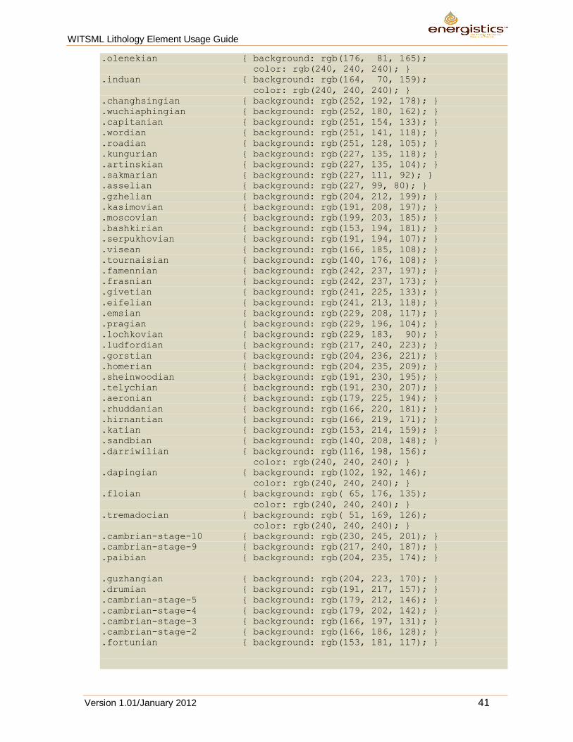
WITSML Lithology Element Usage Guide
Version 1.01/January 2012 41
.olenekian { background: rgb(176, 81, 165);
color: rgb(240, 240, 240); }
.induan { background: rgb(164, 70, 159);
color: rgb(240, 240, 240); }
.changhsingian { background: rgb(252, 192, 178); }
.wuchiaphingian { background: rgb(252, 180, 162); }
.capitanian { background: rgb(251, 154, 133); }
.wordian { background: rgb(251, 141, 118); }
.roadian { background: rgb(251, 128, 105); }
.kungurian { background: rgb(227, 135, 118); }
.artinskian { background: rgb(227, 135, 104); }
.sakmarian { background: rgb(227, 111, 92); }
.asselian { background: rgb(227, 99, 80); }
.gzhelian { background: rgb(204, 212, 199); }
.kasimovian { background: rgb(191, 208, 197); }
.moscovian { background: rgb(199, 203, 185); }
.bashkirian { background: rgb(153, 194, 181); }
.serpukhovian { background: rgb(191, 194, 107); }
.visean { background: rgb(166, 185, 108); }
.tournaisian { background: rgb(140, 176, 108); }
.famennian { background: rgb(242, 237, 197); }
.frasnian { background: rgb(242, 237, 173); }
.givetian { background: rgb(241, 225, 133); }
.eifelian { background: rgb(241, 213, 118); }
.emsian { background: rgb(229, 208, 117); }
.pragian { background: rgb(229, 196, 104); }
.lochkovian { background: rgb(229, 183, 90); }
.ludfordian { background: rgb(217, 240, 223); }
.gorstian { background: rgb(204, 236, 221); }
.homerian { background: rgb(204, 235, 209); }
.sheinwoodian { background: rgb(191, 230, 195); }
.telychian { background: rgb(191, 230, 207); }
.aeronian { background: rgb(179, 225, 194); }
.rhuddanian { background: rgb(166, 220, 181); }
.hirnantian { background: rgb(166, 219, 171); }
.katian { background: rgb(153, 214, 159); }
.sandbian { background: rgb(140, 208, 148); }
.darriwilian { background: rgb(116, 198, 156);
color: rgb(240, 240, 240); }
.dapingian { background: rgb(102, 192, 146);
color: rgb(240, 240, 240); }
.floian { background: rgb( 65, 176, 135);
color: rgb(240, 240, 240); }
.tremadocian { background: rgb( 51, 169, 126);
color: rgb(240, 240, 240); }
.cambrian-stage-10 { background: rgb(230, 245, 201); }
.cambrian-stage-9 { background: rgb(217, 240, 187); }
.paibian { background: rgb(204, 235, 174); }
.guzhangian { background: rgb(204, 223, 170); }
.drumian { background: rgb(191, 217, 157); }
.cambrian-stage-5 { background: rgb(179, 212, 146); }
.cambrian-stage-4 { background: rgb(179, 202, 142); }
.cambrian-stage-3 { background: rgb(166, 197, 131); }
.cambrian-stage-2 { background: rgb(166, 186, 128); }
.fortunian { background: rgb(153, 181, 117); }