Embed Size (px)
Citation preview

Presented to:
By:
Date:
Federal AviationAdministration
Wide Area Augmentation System (WAAS) and Local Area Augmentation System (LAAS) Update
CGSICLeo Eldredge, FAA September 24, 2008

WAAS-LAAS Update - CGSIC 2Federal AviationAdministrationSeptember 24, 2007
For Official Use Only
Agenda
• WAAS Architecture• WAAS Services Overview• WAAS Program Status
– Phase II – Full LPV Performance– Phase III – Full LPV-200 Performance– Phase IV – Dual frequency Operations
• WAAS User Segment Status• LAAS Status
WAAS-LAAS Update - CGSIC 3Federal AviationAdministrationSeptember 24, 2007
For Official Use Only
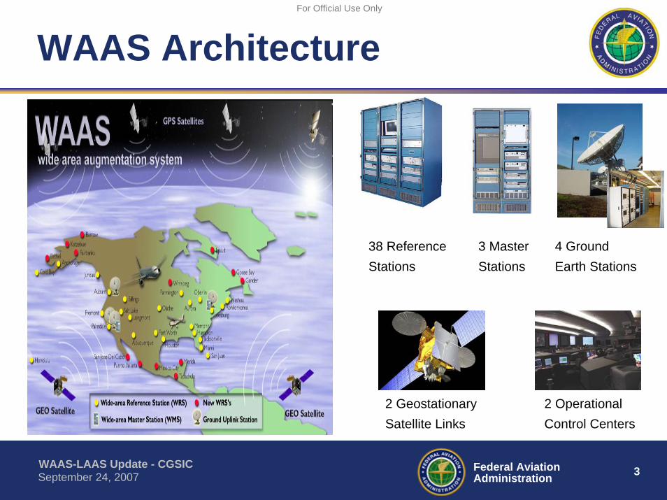
WAAS Architecture
38 Reference Stations
3 Master Stations
4 Ground Earth Stations
2 Geostationary Satellite Links
2 Operational Control Centers

WAAS-LAAS Update - CGSIC 4Federal AviationAdministrationSeptember 24, 2007
For Official Use Only
WAAS Navigation Services
• En Route and Terminal Area Navigation Services– For Aircraft Departure, Arrival, and Domestic Airspace– Supports All RNAV Categories
• Instrument Approach Services– Lateral Navigation (LNAV)
• Non-Precision Approach Guidance for Lateral Only Use – Lateral Navigation with Vertical (LNAV/VNAV)
• Non-Precision Approach Service with Vertical Guidance Capable of Providing Service to ~350 Feet Above Runway Surface
– Localizer Performance with Vertical (LPV)• Equivalent to Instrument Landing System (ILS)• Precision Approach Service With Vertical Guidance as Low as
200 Feet Above the Runway Surface

WAAS-LAAS Update - CGSIC 5Federal AviationAdministrationSeptember 24, 2007
For Official Use Only
Instrument Approach Services
WAAS
½
GPS
WAAS
LAAS

WAAS-LAAS Update - CGSIC 6Federal AviationAdministrationSeptember 24, 2007
For Official Use Only
WAAS LPV Performance
WAAS Performance evaluated based on a total of 1,761 million samples (or 20,389 user days)
GPSStandard
GPSActual
WAAS LPVStandard
WAAS LPVActual
Horizontal 95% 36 m 2.74 m 16 m
3.89 mVertical 95% 77 m
1.08 m
1.26 m20 m
WAAS-LAAS Update - CGSIC 7Federal AviationAdministrationSeptember 24, 2007
For Official Use Only
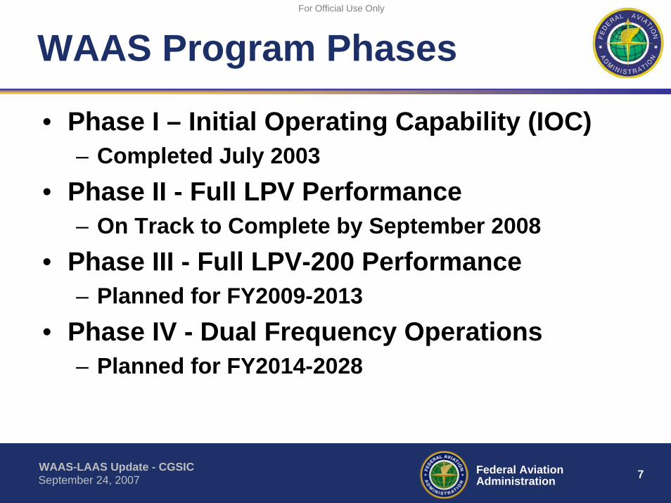
WAAS Program Phases
• Phase I – Initial Operating Capability (IOC)– Completed July 2003
• Phase II - Full LPV Performance– On Track to Complete by September 2008
• Phase III - Full LPV-200 Performance– Planned for FY2009-2013
• Phase IV - Dual Frequency Operations– Planned for FY2014-2028
WAAS-LAAS Update - CGSIC 8Federal AviationAdministrationSeptember 24, 2007
For Official Use Only
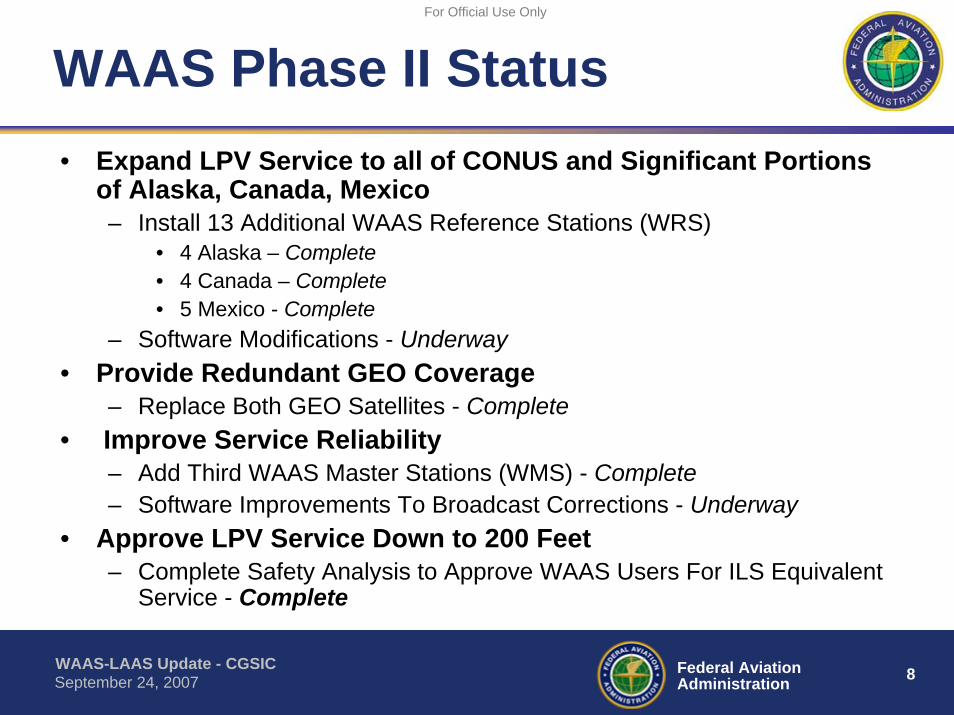
WAAS Phase II Status• Expand LPV Service to all of CONUS and Significant Portions
of Alaska, Canada, Mexico– Install 13 Additional WAAS Reference Stations (WRS)
• 4 Alaska – Complete• 4 Canada – Complete• 5 Mexico - Complete
– Software Modifications - Underway• Provide Redundant GEO Coverage
– Replace Both GEO Satellites - Complete• Improve Service Reliability
– Add Third WAAS Master Stations (WMS) - Complete – Software Improvements To Broadcast Corrections - Underway
• Approve LPV Service Down to 200 Feet– Complete Safety Analysis to Approve WAAS Users For ILS Equivalent
Service - Complete
WAAS-LAAS Update - CGSIC 9Federal AviationAdministrationSeptember 24, 2007
For Official Use Only
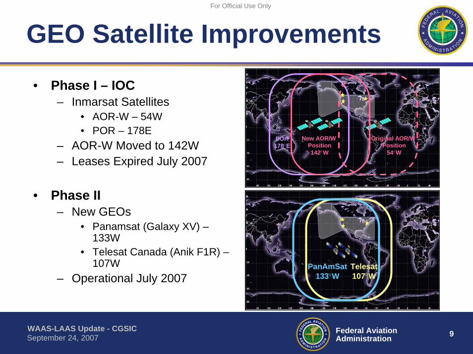
GEO Satellite Improvements
• Phase I – IOC– Inmarsat Satellites
• AOR-W – 54W• POR – 178E
– AOR-W Moved to 142W– Leases Expired July 2007
• Phase II– New GEOs
• Panamsat (Galaxy XV) –133W
• Telesat Canada (Anik F1R) –107W
– Operational July 2007Telesat107°W
PanAmSat133°W
Original AOR/W Position
54°W
POR178°E
New AOR/W Position142°W
WAAS-LAAS Update - CGSIC 10Federal AviationAdministrationSeptember 24, 2007
For Official Use Only
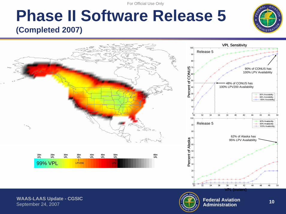
Phase II Software Release 5(Completed 2007)
50mVPL
35mVPL
40mVPL
30mVPL
45mVPL
25mVPL
65mVPL
20mVPL
LPV200 LPV99% VPL
50mVPL
35mVPL
40mVPL
30mVPL
45mVPL
25mVPL
65mVPL
20mVPL
LPV200 LPV99% VPL
VPL (meters)
VPL Sensitivity
62% of Alaska has 95% LPV Availability
48% of CONUS has 100% LPV200 Availability
90% of CONUS has 100% LPV Availability
Perc
ent o
f Ala
ska
Perc
ent o
f CO
NU
S
Release 5
Release 5
VPL (meters)
VPL Sensitivity
62% of Alaska has 95% LPV Availability
48% of CONUS has 100% LPV200 Availability
90% of CONUS has 100% LPV Availability
Perc
ent o
f Ala
ska
Perc
ent o
f CO
NU
S
Release 5
Release 5
WAAS-LAAS Update - CGSIC 11Federal AviationAdministrationSeptember 24, 2007
For Official Use Only
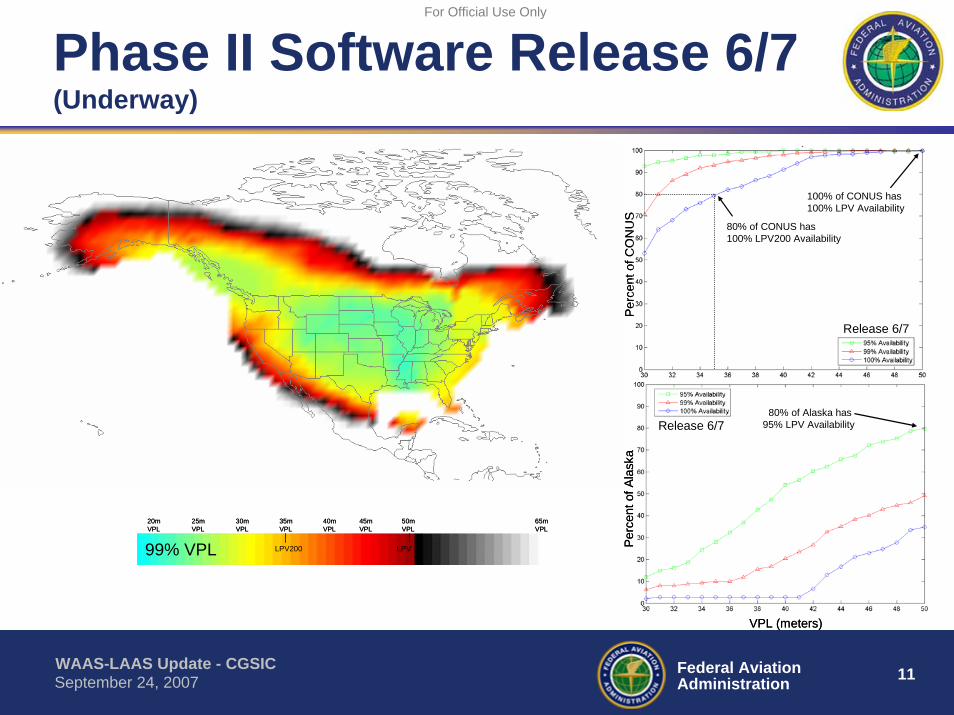
Phase II Software Release 6/7(Underway)
50mVPL
35mVPL
40mVPL
30mVPL
45mVPL
25mVPL
65mVPL
20mVPL
LPV200 LPV99% VPL
50mVPL
35mVPL
40mVPL
30mVPL
45mVPL
25mVPL
65mVPL
20mVPL
LPV200 LPV99% VPL
VPL (meters)
80% of Alaska has 95% LPV Availability
80% of CONUS has 100% LPV200 Availability
100% of CONUS has 100% LPV Availability
Perc
ent o
f Ala
ska
Perc
ent o
f CO
NU
S
Release 6/7
Release 6/7
VPL (meters)
80% of Alaska has 95% LPV Availability
80% of CONUS has 100% LPV200 Availability
100% of CONUS has 100% LPV Availability
Perc
ent o
f Ala
ska
Perc
ent o
f CO
NU
S
Release 6/7
Release 6/7

WAAS-LAAS Update - CGSIC 12Federal AviationAdministrationSeptember 24, 2007
For Official Use Only
Phase II Software Release 8/9(Planned for 2008)
50mVPL
35mVPL
40mVPL
30mVPL
45mVPL
25mVPL
65mVPL
20mVPL
LPV200 LPV99% VPL
50mVPL
35mVPL
40mVPL
30mVPL
45mVPL
25mVPL
65mVPL
20mVPL
LPV200 LPV99% VPL
VPL (meters)
86% of Alaska has 95% LPV Availability
84% of CONUS has 100% LPV200 Availability
100% of CONUS has 100% LPV Availability
Perc
ent o
f Ala
ska
Perc
ent o
f CO
NU
S
Release 8/9
Release 8/9
42% of Alaska has 100% LPV Availability
VPL (meters)
86% of Alaska has 95% LPV Availability
84% of CONUS has 100% LPV200 Availability
100% of CONUS has 100% LPV Availability
Perc
ent o
f Ala
ska
Perc
ent o
f CO
NU
S
Release 8/9
Release 8/9
42% of Alaska has 100% LPV Availability

WAAS-LAAS Update - CGSIC 13Federal AviationAdministrationSeptember 24, 2007
For Official Use Only
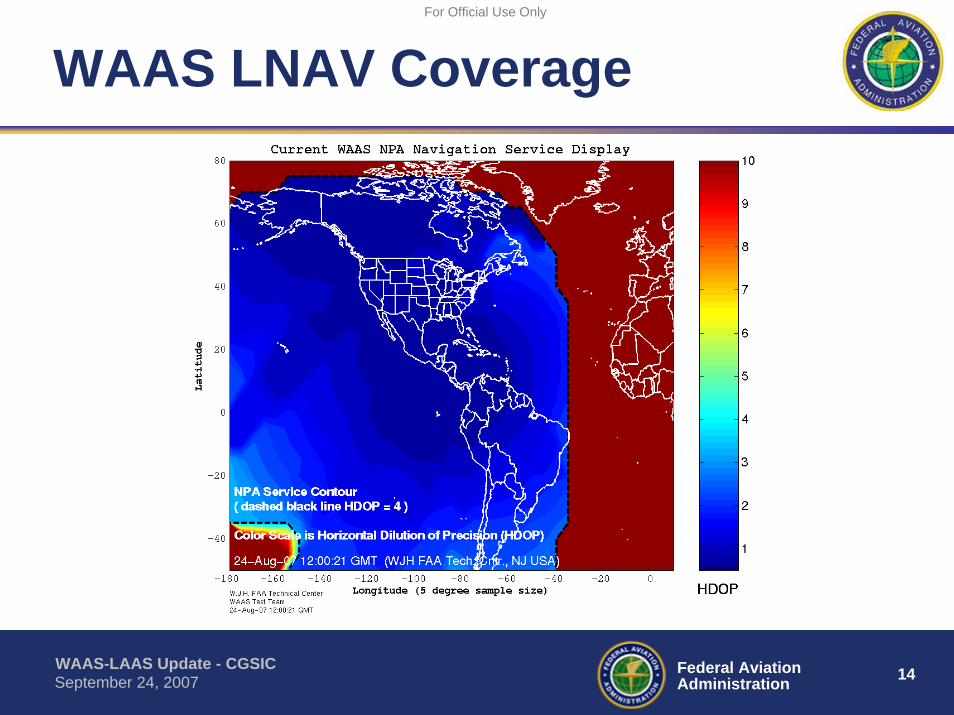
WAAS LPV Coverage
WAAS-LAAS Update - CGSIC 14Federal AviationAdministrationSeptember 24, 2007
For Official Use Only
WAAS LNAV Coverage
WAAS-LAAS Update - CGSIC 15Federal AviationAdministrationSeptember 24, 2007
For Official Use Only
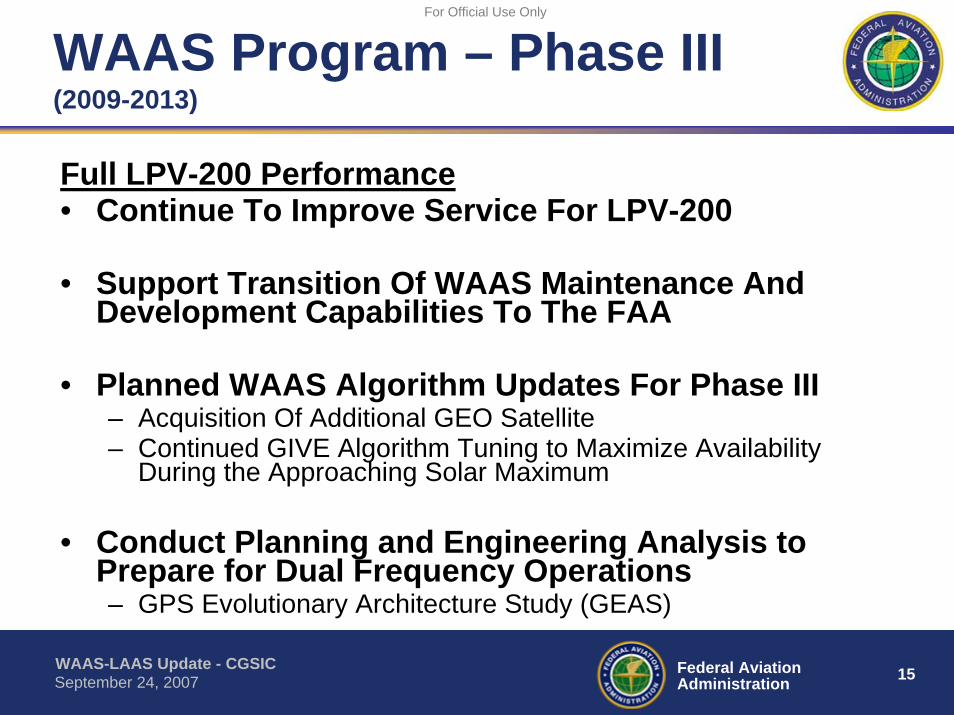
WAAS Program – Phase III(2009-2013)
Full LPV-200 Performance• Continue To Improve Service For LPV-200
• Support Transition Of WAAS Maintenance And Development Capabilities To The FAA
• Planned WAAS Algorithm Updates For Phase III– Acquisition Of Additional GEO Satellite– Continued GIVE Algorithm Tuning to Maximize Availability
During the Approaching Solar Maximum
• Conduct Planning and Engineering Analysis to Prepare for Dual Frequency Operations– GPS Evolutionary Architecture Study (GEAS)

WAAS-LAAS Update - CGSIC 16Federal AviationAdministrationSeptember 24, 2007
For Official Use Only
WAAS Program – Phase IV(2014-2028)
• Dual Frequency Operations– Maintain a robust, reliable, and sustainable LPV-200
capability– Support Single frequency WAAS users through end
of Phase IV (2028)– Implement WAAS Changes Needed for Dual
Frequency (L1/L5) GPS Operations
WAAS-LAAS Update - CGSIC 17Federal AviationAdministrationSeptember 24, 2007
For Official Use Only
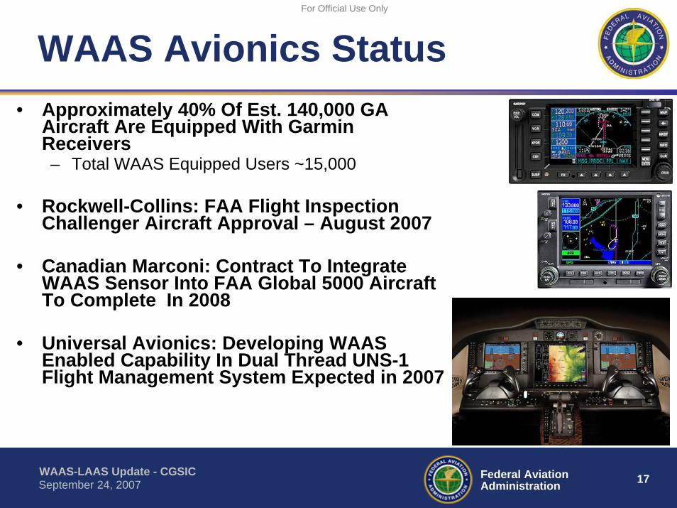
WAAS Avionics Status• Approximately 40% Of Est. 140,000 GA
Aircraft Are Equipped With GarminReceivers– Total WAAS Equipped Users ~15,000
• Rockwell-Collins: FAA Flight Inspection Challenger Aircraft Approval – August 2007
• Canadian Marconi: Contract To Integrate WAAS Sensor Into FAA Global 5000 Aircraft To Complete In 2008
• Universal Avionics: Developing WAAS Enabled Capability In Dual Thread UNS-1 Flight Management System Expected in 2007

WAAS-LAAS Update - CGSIC 18Federal AviationAdministrationSeptember 24, 2007
For Official Use Only
WAAS Procedure Production
3 39263
614
925
0
500
1000
1500
2000Cu
mul
ativ
e P
roce
dure
s
CUMULATIVE LPV GOAL 0 0 100 400 914 1214 1514 1814
LPV to NON-ILS RWY ENDS 1 10 106 328 516
LPV to ILS RWY ENDS 2 29 157 286 409
FY03 FY04 FY05 FY06 FY07 FY08 FY09 FY10
Type of Approach Procedures To DateTotal GNSS Approaches 4225LNAV/VNAV 1121LPV 925

WAAS-LAAS Update - CGSIC 19Federal AviationAdministrationSeptember 24, 2007
For Official Use Only
Local Area Augmentation System (LAAS)
• Precision Approach For Category I, II & III• Multiple Runway Coverage At An Airport• Terminal Area Procedures for Arrival and Departure
WAAS-LAAS Update - CGSIC 20Federal AviationAdministrationSeptember 24, 2007
For Official Use Only
LAAS Status• Integrity Analysis and Prototype Development
– FAA GBAS prototype work under Honeywell Contract – Hazardous Misleading Information (HMI) Analysis underway to validate GBAS
architecture/design• GBAS CAT I Approval Process
– System Design Approval for Honeywell architecture (SLS 4000) Planned to Complete by 2008
• GBAS Avionics– GBAS/LAAS Standards (MASPS / MOPS / TSO / SARPS) completed– Boeing 737-800 series GBAS equipped– Airbus A320, A380 certification planned for 2007
• CAT-III Research & Development Activities– Continuing Work to Develop Requirements Compatible with Aircraft Operations and
Approval Process• International GBAS Cooperation
– International GBAS Working Group– FAA Memorandum of Cooperation established with Australia, Brazil, Spain, Germany

WAAS-LAAS Update - CGSIC 21Federal AviationAdministrationSeptember 24, 2007
For Official Use Only
Questions
WAAS-LAAS Update - CGSIC 22Federal AviationAdministrationSeptember 24, 2007
For Official Use Only
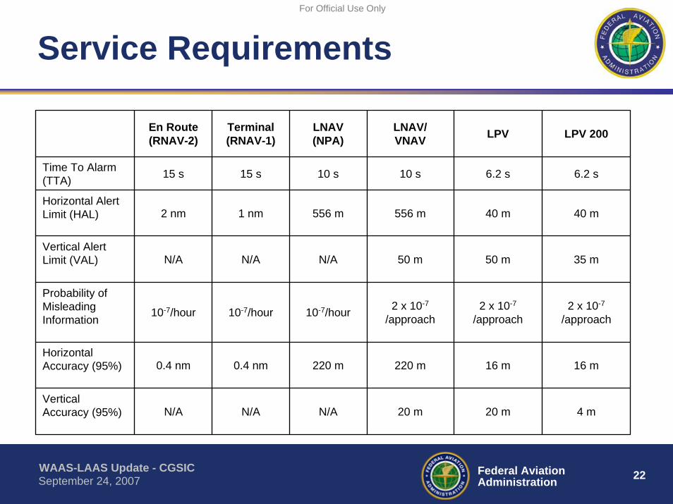
Service Requirements
En Route(RNAV-2)
Terminal(RNAV-1)
LNAV(NPA)
LNAV/VNAV LPV LPV 200
Time To Alarm (TTA) 15 s 15 s 10 s 10 s 6.2 s 6.2 s
Horizontal Alert Limit (HAL) 2 nm 1 nm 556 m 556 m 40 m 40 m
Vertical Alert Limit (VAL) N/A N/A N/A 50 m 50 m 35 m
Probability of Misleading Information 10-7/hour 10-7/hour 10-7/hour 2 x 10⁻⁷
/approach2 x 10-7
/approach2 x 10-7
/approach
Horizontal Accuracy (95%) 0.4 nm 0.4 nm 220 m 220 m 16 m 16 m
Vertical Accuracy (95%) N/A N/A N/A 20 m 20 m 4 m