Embed Size (px)
Citation preview
Wide Area Augmentation System(WAAS)
DAN HANLON
WAAS PROGRAM MANAGER
Tom Salat
WAAS NAS INTEGRATION
GPS in Wide Spread Use
• GPS used in aviation since 1992…provides significant benefits to aviation– Over 3500 non-precision GPS instrument
procedures• Non-precision does not provide descent guidance to pilot
– Provides lower landing minimums for airports w/o Radio Navigation Aids (400’ AGL)
– Reduce reliance on and cost of radio navigation infrastructure

Why Augment GPS?Technical Reasons
• Current GPS constellation cannot support requirements for all phases of flight– Integrity
• Know when it’s providing bad information & correcting for it
– Accuracy• With SA off, GPS vertical accuracy > 15 m• 7m or less need for precision approach
– Availability and continuity• Plan to have it at your destination• Assurance it will be available when arrive
Why Augment GPS?Operational Reasons
1. Provides ILS-like capability for little or no cost
2. Provides primary navigation system capability without line-of-sight limitations
3. Will allow GPS to replace NDBs and >50% VORs and associated avionics in aircraft
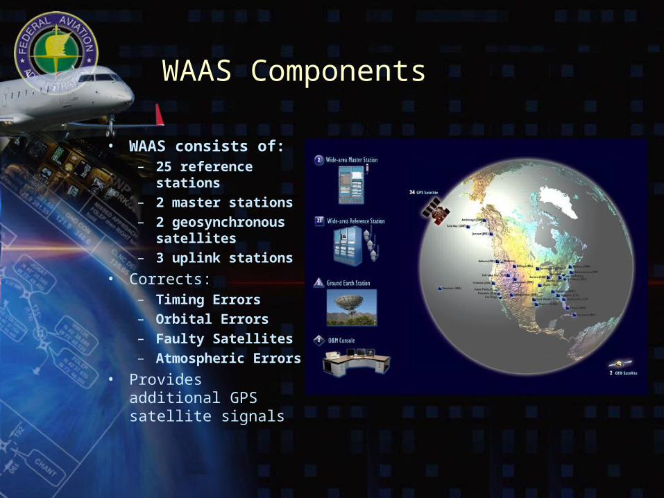
WAAS Components
• WAAS consists of:– 25 reference
stations– 2 master stations– 2 geosynchronous
satellites– 3 uplink stations
• Corrects:– Timing Errors– Orbital Errors– Faulty Satellites– Atmospheric Errors
• Provides additional GPS satellite signals
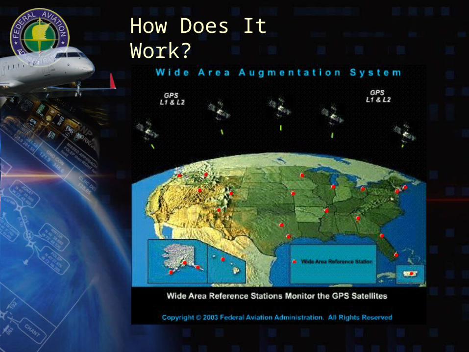
How Does It Work?
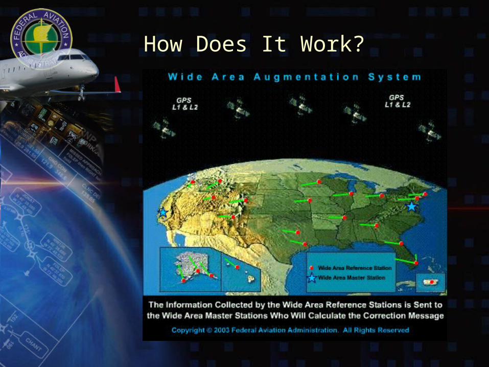
How Does It Work?
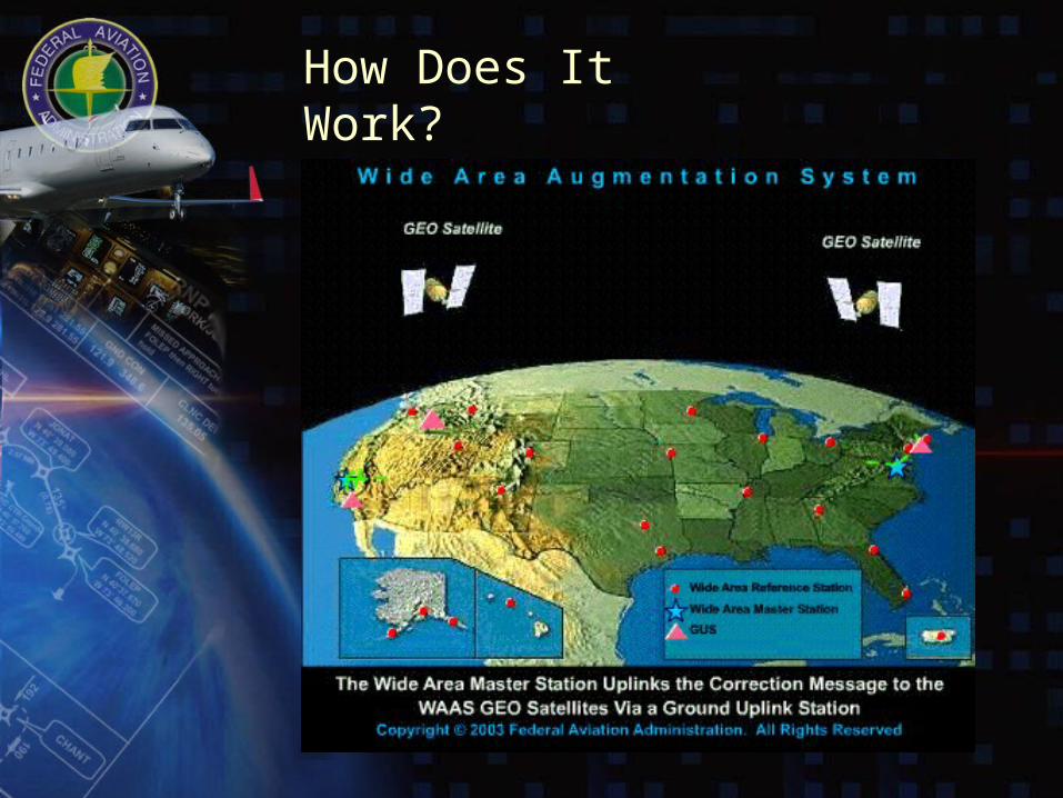
How Does It Work?
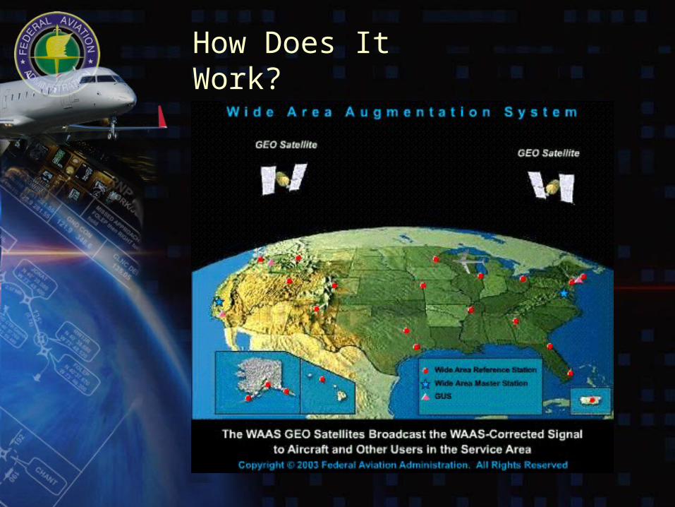
How Does It Work?
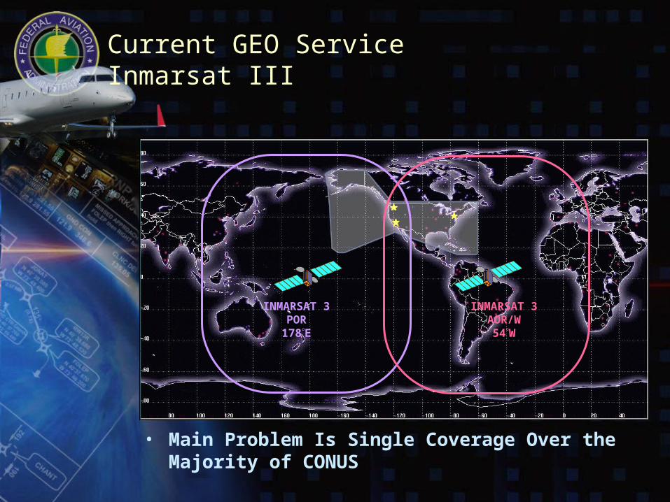
Current GEO ServiceInmarsat III
• Main Problem Is Single Coverage Over the Majority of CONUS
INMARSAT 3AOR/W
54W
INMARSAT 3POR178E
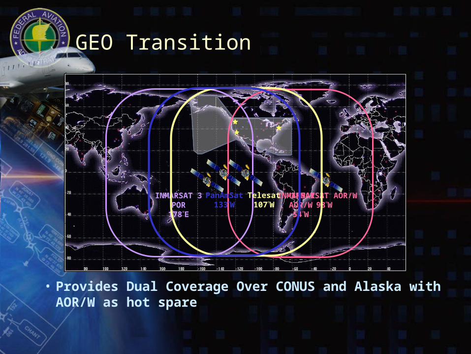
GEO Transition
• Provides Dual Coverage Over CONUS and Alaska with AOR/W as hot spare
INMARSAT 3AOR/W
54W
INMARSAT 3POR178E
INMARSAT AOR/W98W
Telesat107W
PanAmSat133W
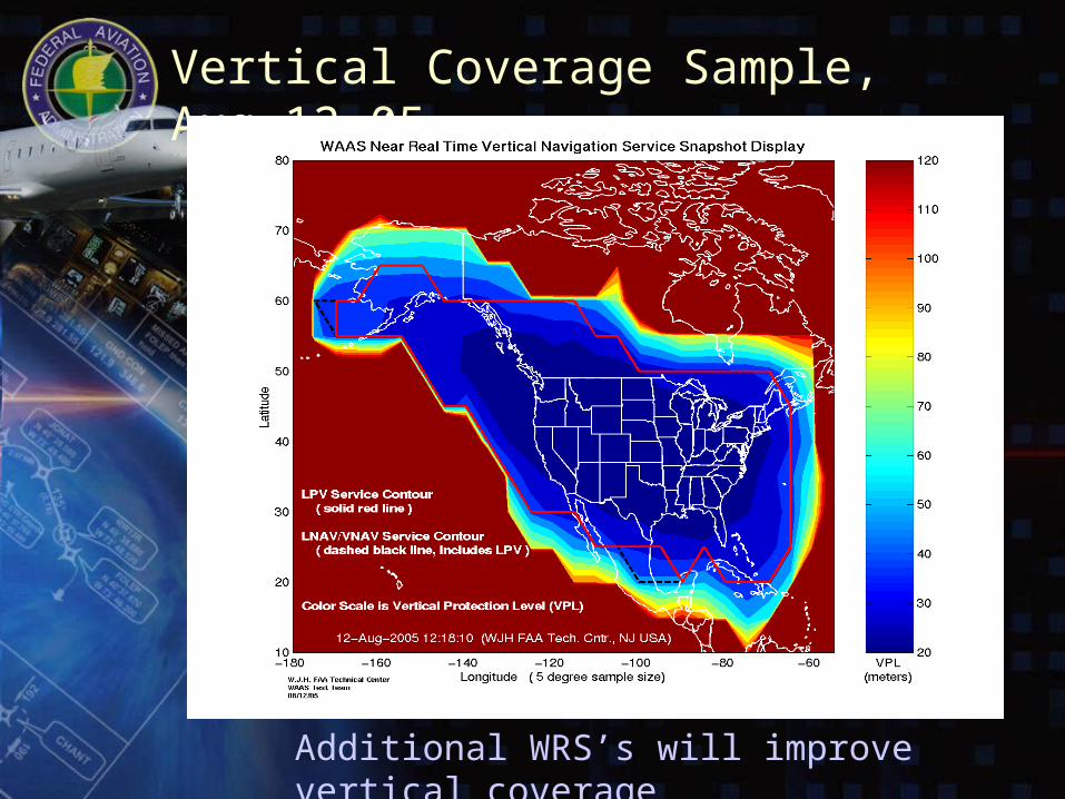
Vertical Coverage Sample, Aug,12 05
Additional WRS’s will improve vertical coverage
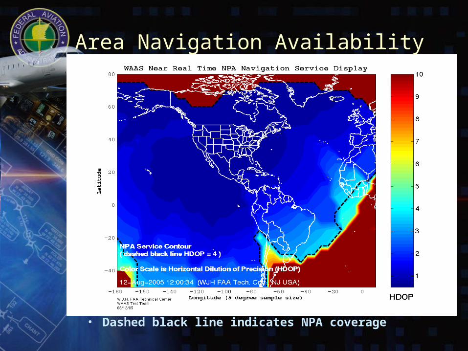
Area Navigation Availability
• Dashed black line indicates NPA coverage
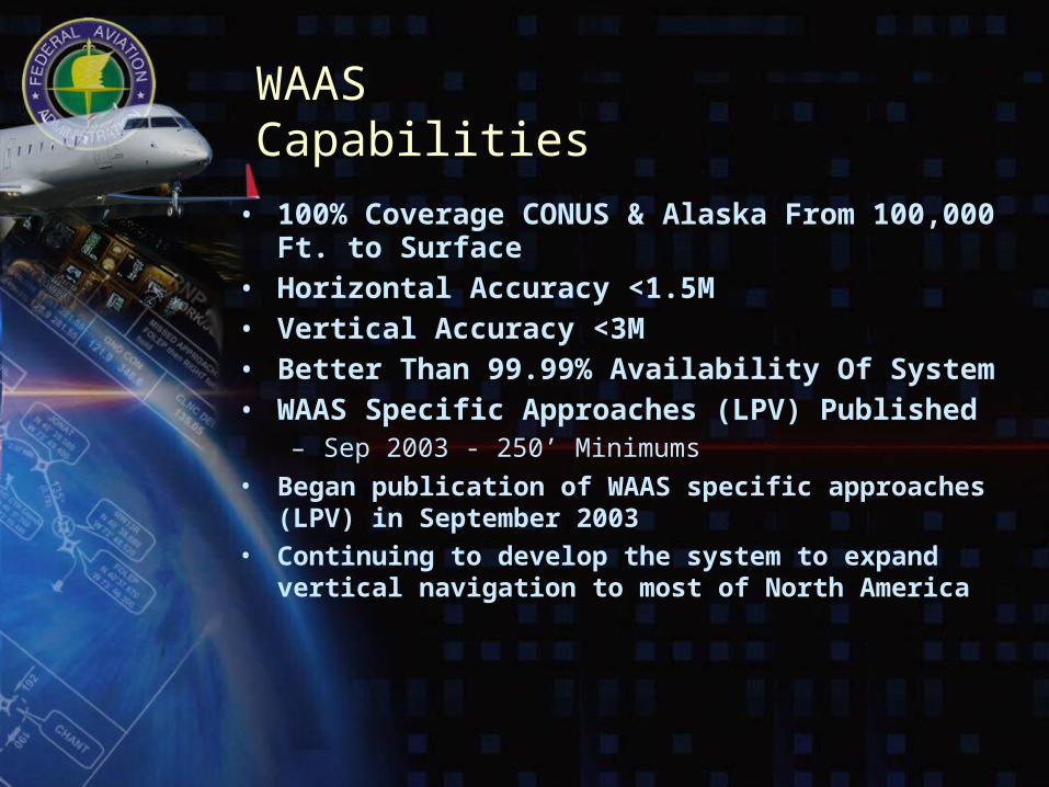
WAAS Capabilities
• 100% Coverage CONUS & Alaska From 100,000 Ft. to Surface
• Horizontal Accuracy <1.5M• Vertical Accuracy <3M• Better Than 99.99% Availability Of System• WAAS Specific Approaches (LPV) Published
– Sep 2003 - 250’ Minimums
• Began publication of WAAS specific approaches (LPV) in September 2003
• Continuing to develop the system to expand vertical navigation to most of North America
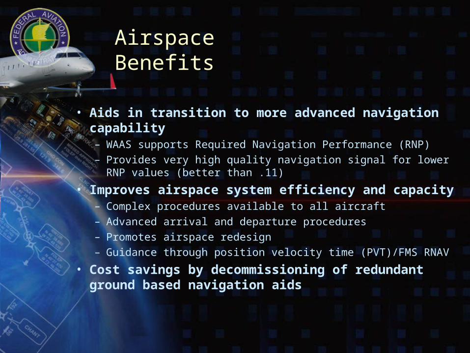
Airspace Benefits
• Aids in transition to more advanced navigation capability– WAAS supports Required Navigation Performance (RNP)– Provides very high quality navigation signal for lower RNP values
(better than .11)
• Improves airspace system efficiency and capacity– Complex procedures available to all aircraft– Advanced arrival and departure procedures– Promotes airspace redesign– Guidance through position velocity time (PVT)/FMS RNAV
• Cost savings by decommissioning of redundant ground based navigation aids
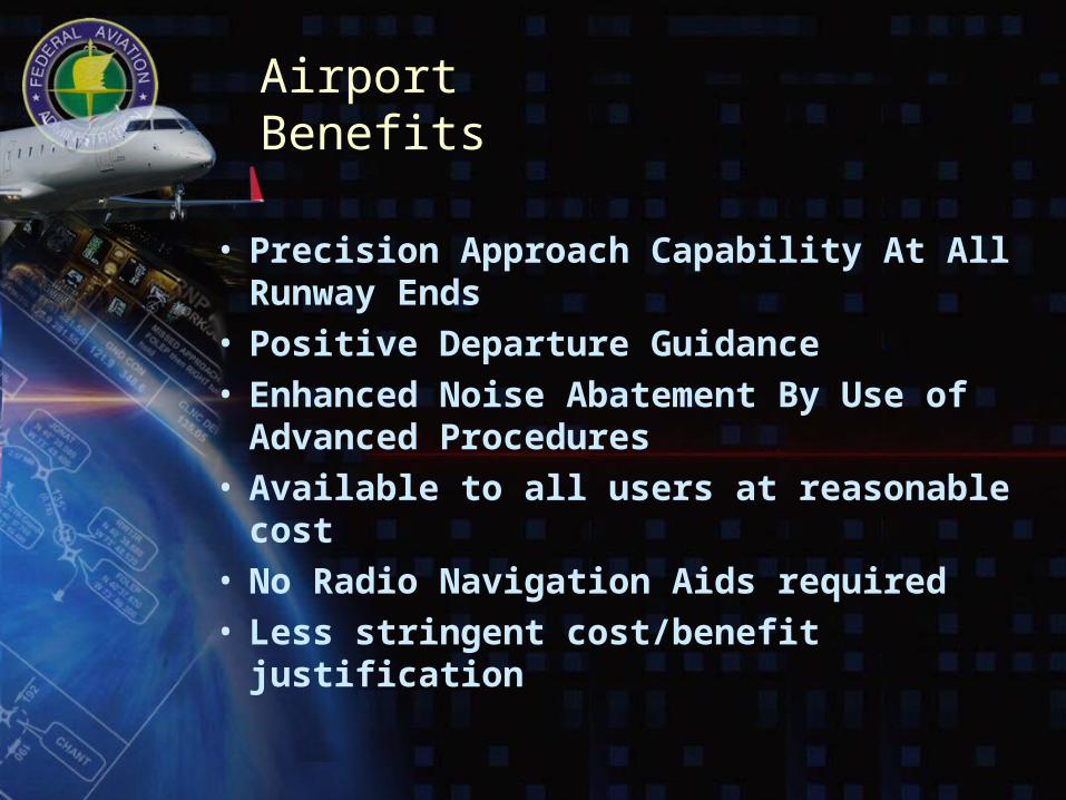
Airport Benefits
• Precision Approach Capability At All Runway Ends
• Positive Departure Guidance• Enhanced Noise Abatement By Use of
Advanced Procedures• Available to all users at reasonable cost• No Radio Navigation Aids required• Less stringent cost/benefit justification

WAAS Avionics
• Certified receivers – Over 2,500 Garmin GNS-480s sold– Chelton systems with Free Flight
Systems WAAS sensor
• Recent developments– 50,000 Garmin units in field that can
be upgraded• Upgrade cost expected to be $1500,
available Fall 2006
– The FAA is currently teaming with other manufacturers to develop additional LPV receivers in all functional classes
GNS-480
GNS-530
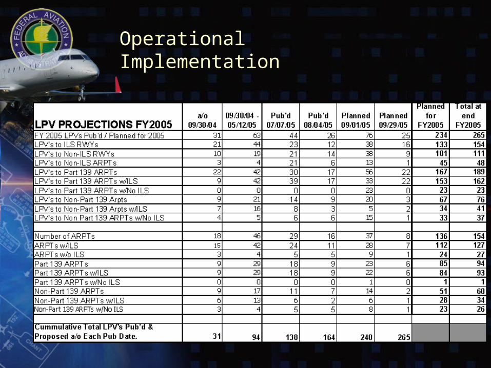
Operational Implementation
GLS 200’
3o
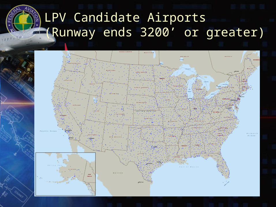
LPV Candidate Airports(Runway ends 3200’ or greater)
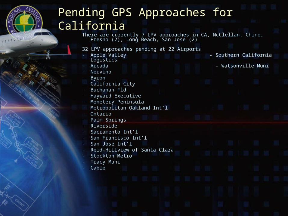
Pending GPS Approaches for CaliforniaThere are currently 7 LPV approaches in CA, McClellan, Chino, Fresno (2), Long
Beach, San Jose (2)
32 LPV approaches pending at 22 Airports- Apple Valley - Southern California Logistics- Arcada - Watsonville Muni- Nervino- Byron- California City- Buchanan Fld- Hayward Executive- Monetery Peninsula- Metropolitan Oakland Int’l- Ontario- Palm Springs- Riverside- Sacramento Int’l- San Francisco Int’l- San Jose Int’l- Reid-Hillview of Santa Clara- Stockton Metro- Tracy Muni- Cable
Preparing your airport for WAAS
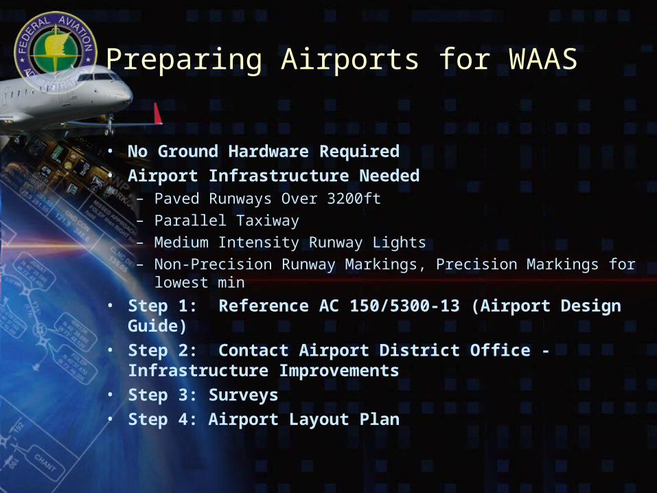
Preparing Airports for WAAS
• No Ground Hardware Required • Airport Infrastructure Needed
– Paved Runways Over 3200ft
– Parallel Taxiway
– Medium Intensity Runway Lights
– Non-Precision Runway Markings, Precision Markings for lowest min
• Step 1: Reference AC 150/5300-13 (Airport Design Guide)• Step 2: Contact Airport District Office - Infrastructure
Improvements• Step 3: Surveys• Step 4: Airport Layout Plan
STEP 1 – AC 150/5300 - 13
• AC 150/5300-13 Airport Design provides the guidance for developing the airport– Appendix 16 defines the requirements for new instrument
approaches • Table A16-1B defines the requirements for APV-RNP
instrument procedures (LPV)
• Lower requirements for higher minimums
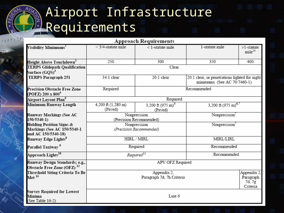
Airport Infrastructure Requirements
STEP 2 – Airports District Office
• Make Contact with the Airports District Office for your area to discuss and determine what infrastructure requirements will yield the lowest minimums against cost and time constraints – Review current infrastructure and determine (from Table A16-
1B) what visibility minimums are required
– Determine in conjunction with the ADO determine what infrastructure changes are best for the airport
• If the current infrastructure does not meet the requirements then an upgrade to the infrastructure is required or reduced minima will be used to develop the procedure
STEP 3 – Surveys
• Refer to Table A16-2 to determine the type of survey required and then determine if your airport has a current survey of the appropriate type– All airport surveys must be FAA 405 compliant– ANA-PC or PIR survey required– Can use 405 type D survey
• If an appropriate type survey is not available, then review the required documents and initiate a request for a survey of the appropriate type
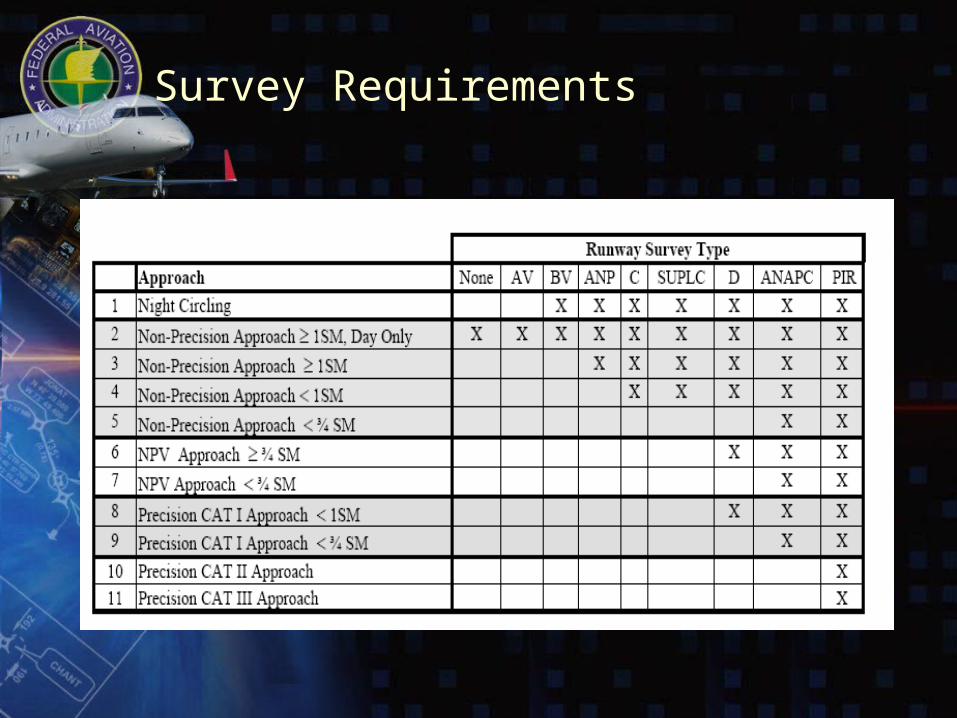
Survey Requirements
STEP 4 – Airport Layout Plan
• Based on information from Table A16-1B, verify the appropriate level of service is indicated on the Approved Airport Layout Plan
• If the appropriate level of service is not on the approved ALP, then take action to update the ALP to the appropriate level of service
Questions?You can find more details on our website at:http://gps.faa.gov
Procedures information can be accessed at:http://avn.faa.gov
Survey information can be accessed at:http://www.ngs.noaa.gov/AERO/aero.html