Embed Size (px)
Citation preview
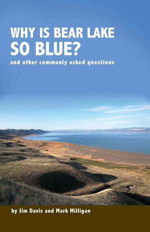
WHY IS BEAR LAKE SO BLUE?and other commonly asked questions
by Jim Davis and Mark Milligan
CONTENTSINTRODUCTION................................................................................................................................... 2WHERE IS BEAR LAKE? ................................................................................................................... 4WHY IS THERE A BIG, DEEP LAKE HERE? .............................................................................. 6WHY IS BEAR LAKE SO BLUE? ................................................................................................... 10WHAT IS THE SHORELINE LIKE? ............................................................................................. 12WHEN WAS BEAR LAKE DISCOVERED AND SETTLED? ................................................. 15HOW OLD IS BEAR LAKE? ............................................................................................................ 16WHEN DID THE BEAR RIVER AND BEAR LAKE MEET? ................................................ 17WHAT LIVES IN BEAR LAKE? ..................................................................................................... 20DOES BEAR LAKE FREEZE? ......................................................................................................... 24WHAT IS THE WEATHER AT BEAR LAKE? .......................................................................... 26WHAT DID BEAR LAKE LOOK LIKE DURING THE ICE AGE? ......................................... 28WHAT IS KARST?.............................................................................................................................. 29WHY IS SCUBA DIVING POPULAR IN BEAR LAKE? ........................................................... 30HOW HAVE PEOPLE MODIFIED BEAR LAKE? ..................................................................... 34WHY IS THE LAKE SO LOW OR WHY IS IT SO HIGH? ...................................................... 36WHAT IS THE “LAW OF THE LAKE”?....................................................................................... 36WHO OWNS THE LAKE BED? ..................................................................................................... 37BEAR BITES ........................................................................................................................................ 38ACKNOWLEDGMENTS ................................................................................................................... 41
1
2
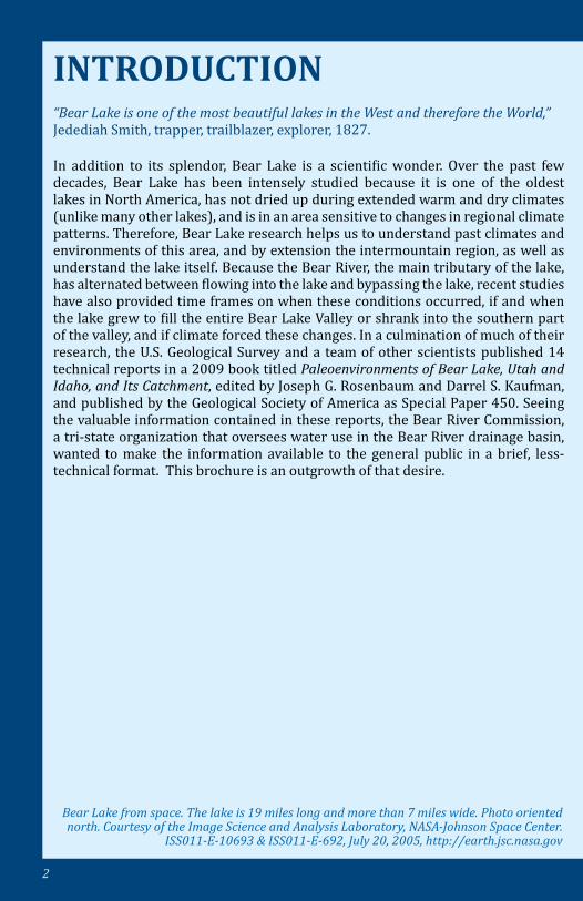
INTRODUCTION
In addition to its splendor, Bear Lake is a scientific wonder. Over the past few decades, Bear Lake has been intensely studied because it is one of the oldest lakes in North America, has not dried up during extended warm and dry climates (unlike many other lakes), and is in an area sensitive to changes in regional climate patterns. Therefore, Bear Lake research helps us to understand past climates and environments of this area, and by extension the intermountain region, as well as understand the lake itself. Because the Bear River, the main tributary of the lake, has alternated between flowing into the lake and bypassing the lake, recent studies have also provided time frames on when these conditions occurred, if and when the lake grew to fill the entire Bear Lake Valley or shrank into the southern part of the valley, and if climate forced these changes. In a culmination of much of their research, the U.S. Geological Survey and a team of other scientists published 14 technical reports in a 2009 book titled Paleoenvironments of Bear Lake, Utah and Idaho, and Its Catchment, edited by Joseph G. Rosenbaum and Darrel S. Kaufman, and published by the Geological Society of America as Special Paper 450. Seeing the valuable information contained in these reports, the Bear River Commission, a tri-state organization that oversees water use in the Bear River drainage basin, wanted to make the information available to the general public in a brief, less-technical format. This brochure is an outgrowth of that desire.
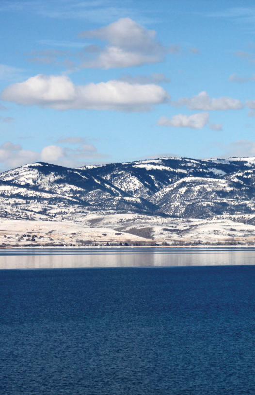
“Bear Lake is one of the most beautiful lakes in the West and therefore the World,” Jedediah Smith, trapper, trailblazer, explorer, 1827.
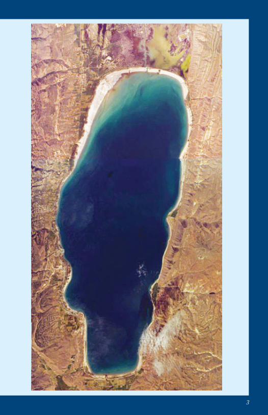
Bear Lake from space. The lake is 19 miles long and more than 7 miles wide. Photo oriented north. Courtesy of the Image Science and Analysis Laboratory, NASA-Johnson Space Center.
ISS011-E-10693 & ISS011-E-692, July 20, 2005, http://earth.jsc.nasa.gov
3
4
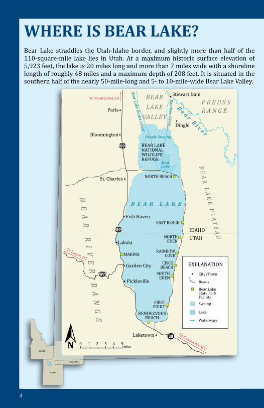
Bear Lake straddles the Utah-Idaho border, and slightly more than half of the 110-square-mile lake lies in Utah. At a maximum historic surface elevation of 5,923 feet, the lake is 20 miles long and more than 7 miles wide with a shoreline length of roughly 48 miles and a maximum depth of 208 feet. It is situated in the southern half of the nearly 50-mile-long and 5- to 10-mile-wide Bear Lake Valley.
WHERE IS BEAR LAKE?
IDAHO
UTAH
WYOMING
EXPLANATION
City/Town
Roads
Bear Lake State Park FacilitySwamp
Lake
Waterways
MARINA
FIRST POINT
SOUTH EDEN
CISCOBEACH
RAINBOW COVE
NORTH EDEN
BEAR LAKENATIONAL WILDLIFE REFUGE
Dingle Swamp
B e a r R i v e r
Rainbow
Canal
Bear Lake O
utlet Canal
Mud Lake
St. Charles
Bloomington
To Montpelier, ID
Paris
Fish Haven
Lakota
Garden City
Pickleville
RENDEZVOUS BEACH
NORTH BEACH
EAST BEACH
IDAHOUTAH
Laketown
B E A R L A K E
BE
AR
R
IV
ER
R
AN
GE
BE
AR
LA
KE
PL
AT
EA
U
P R E U S S R A N G E
BEAR
LAKE
VALLEY
30
To Logan, UT
To Kemmerer, WY
Dingle
Stewart Dam
N 0 1 2 3 4 5 miles
5
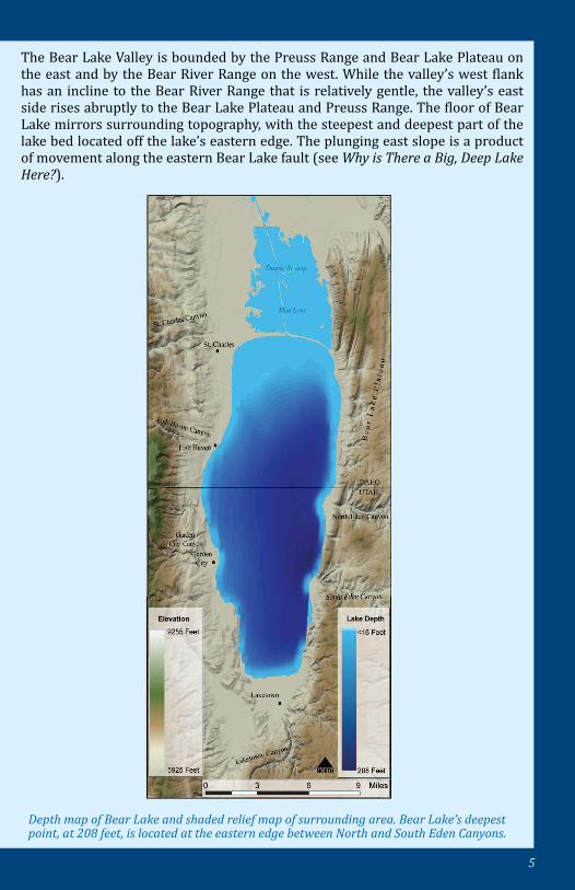
Depth map of Bear Lake and shaded relief map of surrounding area. Bear Lake’s deepest point, at 208 feet, is located at the eastern edge between North and South Eden Canyons.
The Bear Lake Valley is bounded by the Preuss Range and Bear Lake Plateau on the east and by the Bear River Range on the west. While the valley’s west flank has an incline to the Bear River Range that is relatively gentle, the valley’s east side rises abruptly to the Bear Lake Plateau and Preuss Range. The floor of Bear Lake mirrors surrounding topography, with the steepest and deepest part of the lake bed located off the lake’s eastern edge. The plunging east slope is a product of movement along the eastern Bear Lake fault (see Why is There a Big, Deep Lake Here?).
6
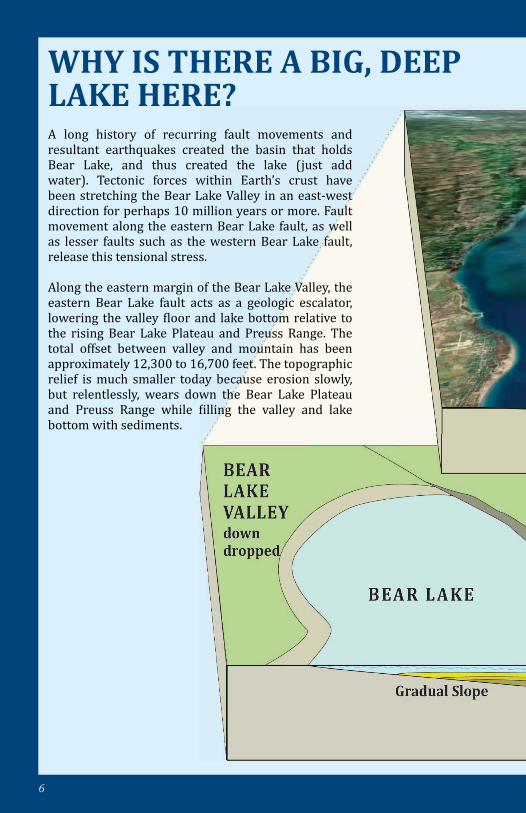
WHY IS THERE A BIG, DEEP LAKE HERE? A long history of recurring fault movements and resultant earthquakes created the basin that holds Bear Lake, and thus created the lake (just add water). Tectonic forces within Earth’s crust have been stretching the Bear Lake Valley in an east-west direction for perhaps 10 million years or more. Fault movement along the eastern Bear Lake fault, as well as lesser faults such as the western Bear Lake fault, release this tensional stress.
Along the eastern margin of the Bear Lake Valley, the eastern Bear Lake fault acts as a geologic escalator, lowering the valley floor and lake bottom relative to the rising Bear Lake Plateau and Preuss Range. The total offset between valley and mountain has been approximately 12,300 to 16,700 feet. The topographic relief is much smaller today because erosion slowly, but relentlessly, wears down the Bear Lake Plateau and Preuss Range while filling the valley and lake bottom with sediments.
7
WHY IS THERE A BIG, DEEP LAKE HERE?
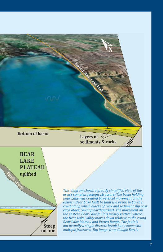
This diagram shows a greatly simplified view of the area’s complex geologic structure. The basin holding Bear Lake was created by vertical movement on the eastern Bear Lake fault (a fault is a break in Earth’s crust along which blocks of rock and sediment slip past each other, causing earthquakes). The movement on the eastern Bear Lake fault is mostly vertical where the Bear Lake Valley moves down relative to the rising Bear Lake Plateau and Preuss Range. The fault is not actually a single discrete break but a zone with multiple fractures. Top image from Google Earth.
8
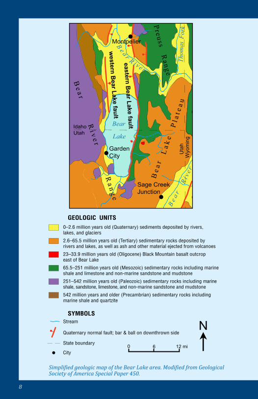
Simplified geologic map of the Bear Lake area. Modified from Geological Society of America Special Paper 450.
GEOLOGIC UNITS
SYMBOLS
0–2.6 million years old (Quaternary) sediments deposited by rivers, lakes, and glaciers
2.6–65.5 million years old (Tertiary) sedimentary rocks deposited by rivers and lakes, as well as ash and other material ejected from volcanoes
23–33.9 million years old (Oligocene) Black Mountain basalt outcrop east of Bear Lake
65.5–251 million years old (Mesozoic) sedimentary rocks including marine shale and limestone and non-marine sandstone and mudstone
251–542 million years old (Paleozoic) sedimentary rocks including marine shale, sandstone, limestone, and non-marine sandstone and mudstone
Stream
542 million years and older (Precambrian) sedimentary rocks including marine shale and quartzite
Quaternary normal fault; bar & ball on downthrown side
City
Smith
s
Thom
as
Fork
Fork
Bear
Lake
0
Wyo
min
gU
tah
UtahIdaho
Preuss Range
Be a r R
i v e r Ra n g e
western B
ear Lake faulteastern B
ear Lake fault
Evanston
GardenCity
Sage CreekJunction
Cokeville
R i v e r
R i v
e r
B e a
r Twin Creek
Be a
rL
a ke
Pl a
t ea u
Montpelier
0 6 12 mi lN
State boundary
R i v e r
B e a r
9
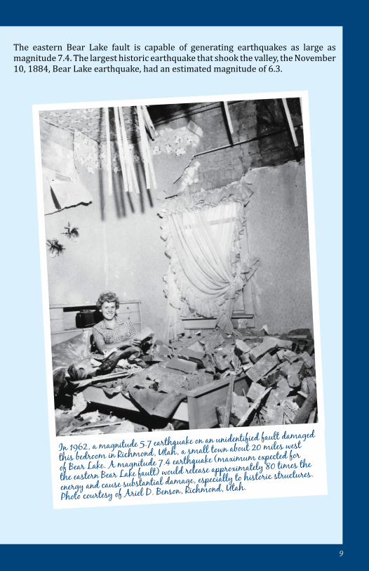
In 1962, a magnitude 5.7 earthquake on an unidentified fault damaged
this bedroom in Richmond, Utah, a small town about 20 miles west
of Bear Lake. A magnitude 7.4 earthquake (maximum expected for
the eastern Bear Lake fault) would release approximately 80 times the
energy and cause substantial damage, especially to historic structures.
Photo courtesy of Ariel D. Benson, Richmond, Utah.
The eastern Bear Lake fault is capable of generating earthquakes as large as magnitude 7.4. The largest historic earthquake that shook the valley, the November 10, 1884, Bear Lake earthquake, had an estimated magnitude of 6.3.
10
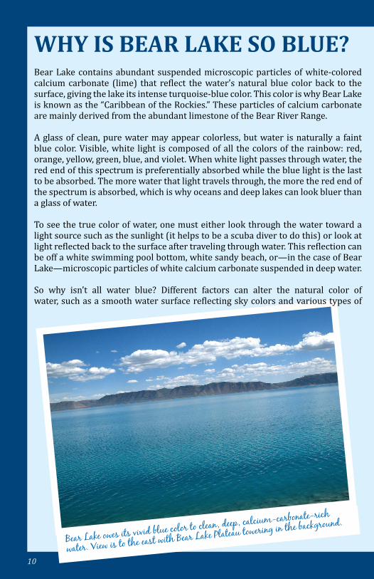
Bear Lake owes its vivid blue color to clean, deep, calcium-carbonate-rich
water. View is to the east with Bear Lake Plateau towering in the background.
WHY IS BEAR LAKE SO BLUE?Bear Lake contains abundant suspended microscopic particles of white-colored calcium carbonate (lime) that reflect the water’s natural blue color back to the surface, giving the lake its intense turquoise-blue color. This color is why Bear Lake is known as the “Caribbean of the Rockies.” These particles of calcium carbonate are mainly derived from the abundant limestone of the Bear River Range.
A glass of clean, pure water may appear colorless, but water is naturally a faint blue color. Visible, white light is composed of all the colors of the rainbow: red, orange, yellow, green, blue, and violet. When white light passes through water, the red end of this spectrum is preferentially absorbed while the blue light is the last to be absorbed. The more water that light travels through, the more the red end of the spectrum is absorbed, which is why oceans and deep lakes can look bluer than a glass of water.
To see the true color of water, one must either look through the water toward a light source such as the sunlight (it helps to be a scuba diver to do this) or look at light reflected back to the surface after traveling through water. This reflection can be off a white swimming pool bottom, white sandy beach, or—in the case of Bear Lake—microscopic particles of white calcium carbonate suspended in deep water.
So why isn’t all water blue? Different factors can alter the natural color of water, such as a smooth water surface reflecting sky colors and various types of
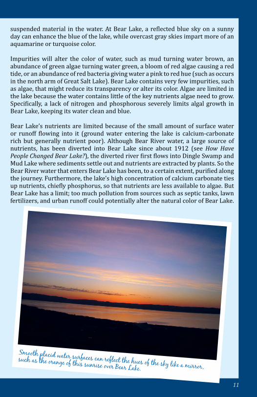
11
Smooth placid water surfaces can reflect the hues of the sky like a mirror, such as the orange of this sunrise over Bear Lake.
suspended material in the water. At Bear Lake, a reflected blue sky on a sunny day can enhance the blue of the lake, while overcast gray skies impart more of an aquamarine or turquoise color.
Impurities will alter the color of water, such as mud turning water brown, an abundance of green algae turning water green, a bloom of red algae causing a red tide, or an abundance of red bacteria giving water a pink to red hue (such as occurs in the north arm of Great Salt Lake). Bear Lake contains very few impurities, such as algae, that might reduce its transparency or alter its color. Algae are limited in the lake because the water contains little of the key nutrients algae need to grow. Specifically, a lack of nitrogen and phosphorous severely limits algal growth in Bear Lake, keeping its water clean and blue.
Bear Lake’s nutrients are limited because of the small amount of surface water or runoff flowing into it (ground water entering the lake is calcium-carbonate rich but generally nutrient poor). Although Bear River water, a large source of nutrients, has been diverted into Bear Lake since about 1912 (see How Have People Changed Bear Lake?), the diverted river first flows into Dingle Swamp and Mud Lake where sediments settle out and nutrients are extracted by plants. So the Bear River water that enters Bear Lake has been, to a certain extent, purified along the journey. Furthermore, the lake’s high concentration of calcium carbonate ties up nutrients, chiefly phosphorus, so that nutrients are less available to algae. But Bear Lake has a limit; too much pollution from sources such as septic tanks, lawn fertilizers, and urban runoff could potentially alter the natural color of Bear Lake.
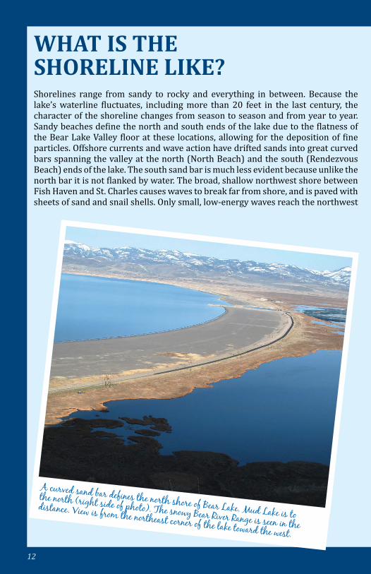
12
A curved sand bar defines the north shore of Bear Lake. Mud Lake is to
the north (right side of photo). The snowy Bear River Range is seen in the
distance. View is from the northeast corner of the lake toward the west.
WHAT IS THE SHORELINE LIKE?Shorelines range from sandy to rocky and everything in between. Because the lake’s waterline fluctuates, including more than 20 feet in the last century, the character of the shoreline changes from season to season and from year to year. Sandy beaches define the north and south ends of the lake due to the flatness of the Bear Lake Valley floor at these locations, allowing for the deposition of fine particles. Offshore currents and wave action have drifted sands into great curved bars spanning the valley at the north (North Beach) and the south (Rendezvous Beach) ends of the lake. The south sand bar is much less evident because unlike the north bar it is not flanked by water. The broad, shallow northwest shore between Fish Haven and St. Charles causes waves to break far from shore, and is paved with sheets of sand and snail shells. Only small, low-energy waves reach the northwest
13
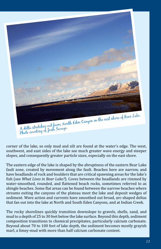
A delta stretches out from North Eden Canyon on the east shore of Bear Lake.
Photo courtesy of Josh Savage.
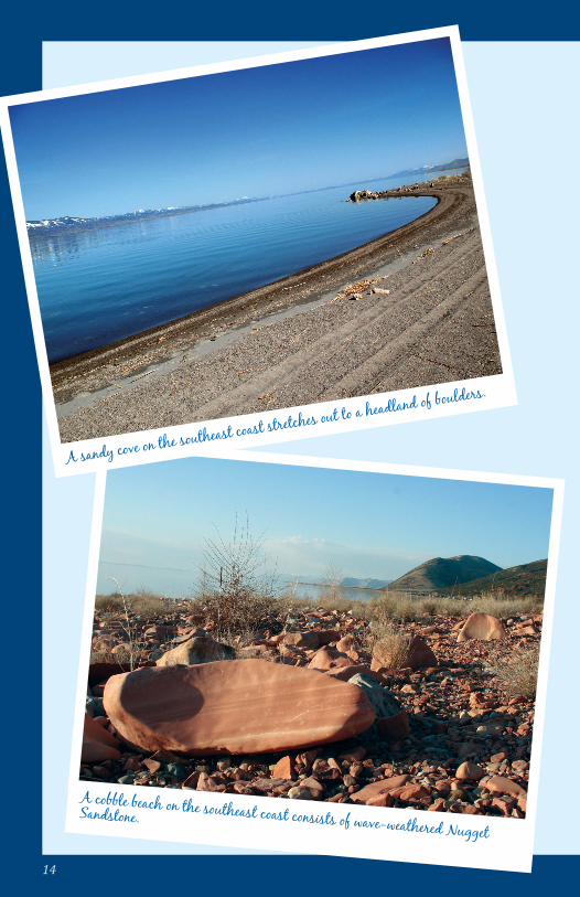
corner of the lake, so only mud and silt are found at the water’s edge. The west, southwest, and east sides of the lake see much greater wave energy and steeper slopes, and consequently greater particle sizes, especially on the east shore.
The eastern edge of the lake is shaped by the abruptness of the eastern Bear Lake fault zone, created by movement along the fault. Beaches here are narrow, and have headlands of rock and boulders that are critical spawning areas for the lake’s fish (see What Lives in Bear Lake?). Coves between the headlands are rimmed by water-smoothed, rounded, and flattened beach rocks, sometimes referred to as shingle beaches. Some flat areas can be found between the narrow beaches where streams exiting the canyons of the plateau meet the lake and deposit wedges of sediment. Wave action and currents have smoothed out broad, arc-shaped deltas that fan out into the lake at North and South Eden Canyons, and at Indian Creek.
The rocky shorelines quickly transition downslope to gravels, shells, sand, and mud to a depth of 25 to 30 feet below the lake surface. Beyond this depth, sediment composition transitions to chemical precipitates, particularly calcium carbonate. Beyond about 70 to 100 feet of lake depth, the sediment becomes mostly grayish marl, a limey-mud with more than half calcium carbonate content.
14
A cobble beach on the southeast coast consists of wave-weathered Nugget Sandstone.
A sandy cove on the southeast coast stretches out to a headland of boulders.
15
WHEN WAS BEAR LAKE DISCOVERED AND SETTLED?Paleoindians first reached western North America more than 12,000 years ago and likely visited or inhabited the Bear Lake Valley, but left little evidence. Indigenous people of the Shoshone, Bannock, and Ute tribes all roamed the Bear Lake area, migrating to the prime hunting and fishing grounds in the warm seasons, and trading with each other and later with fur trappers. American and European trappers first saw Bear Lake in the early 1800s. Donald “Fats” MacKenzie is honored for naming the lake Black Bear’s Lake in 1819, later shortened to Bear Lake.
In the summers of 1827 and 1828, two of the 16 great “(Rocky) Mountain Man Rendezvous” took place at the south beach of Bear Lake, now called Rendezvous Beach. Thousands of American Indians, traders, and trappers, including significant figures Jedediah Smith and Jim Bridger, participated in the Rendezvous. Today, the state park at Rendezvous Beach hosts an annual reenactment of these celebrated gatherings.
The first permanent settler in the valley was Thomas “Peg Leg” Smith, whose trading post was near Dingle, Idaho, in the 1840s. Smith provided supplies to emigrants on the Oregon Trail who traversed through the northern part of the Bear Lake Valley. More settlers arrived in the valley when Mormon pioneers established the community of Paris, Idaho, in 1863, and in ensuing years founded many other towns in Bear Lake Valley.
16
HOW OLD IS BEAR LAKE?Bear Lake is regarded to be one of the oldest lakes in North America; however, its exact age is unknown. The longest sediment core extracted from the lake bottom indicates that the lake is at least 250,000 years old, but it is likely twice that old, and could be several million years in age. Most lakes, by their nature, are short-lived through geologic time because they tend to fill with sediment, becoming wetlands and eventually dry land. But if a basin deepens at a rate faster than sediments accumulate, the lake persists; such is the case with Bear Lake. With every ground-displacing earthquake on the eastern Bear Lake fault, the Bear Lake Valley drops (see Why is There a Big, Deep Lake Here?). Consequently, dropping of Bear Lake Valley outpaces the accumulation of sediment on the lake bed. If the lake formed when the valley began to drop about 10 million years ago, then Bear Lake’s story is indeed very old.
In addition to a dropping basin, a lake needs a steady source of water to survive, especially in a semiarid environment such as the modern Bear Lake Valley (see What is the Weather at Bear Lake?). The Bear River is the largest stream flowing into Bear Lake Valley, but it has not always been connected to the lake (see When Did the Bear River and Bear Lake Meet?). Without input from the river, the lake is sustained primarily by spring-fed streams and ground water entering the lake directly. Ground water provides a more consistent flow of water than local rain and snow-fed streams, enabling Bear Lake to persist through major climatic and hydrologic changes through long periods of time.
Another line of evidence for the age of Bear Lake can be found around Bear Lake Valley as ancient shorelines, marking former lake levels. Shorelines above Bear Lake have been recorded as high as 230 feet above the current lake level. The large offset between ancient shoreline and modern lake level is mostly caused by Bear Lake Valley moving downward relative to the mountains at each major earthquake. Based on rates of fault movement, the uppermost relict shoreline, and thus the lake, is thought to be around 2.5 to 3 million years old.
Biologic evidence also points to an old age for Bear Lake. Several species of fish are found only in Bear Lake (see What Lives in Bear Lake?), as well as other organisms such as snails and crustaceans. Locations containing endemics—species found in only one area on Earth—characteristically have had a relatively stable environment for a great period of time. Long time spans allow for the possibility of genetic drift of a species, so that new species may emerge. A long-standing, steady environment can also act as a refuge for a species, thwarting their extinction.
17
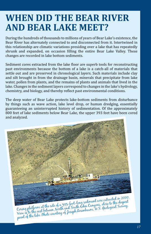
WHEN DID THE BEAR RIVER AND BEAR LAKE MEET? During the hundreds of thousands to millions of years of Bear Lake’s existence, the Bear River has alternately connected to and disconnected from it. Intertwined in this relationship are climatic variations presiding over a lake that has repeatedly shrunk and expanded, on occasion filling the entire Bear Lake Valley. These changes are recorded in lake bottom sediments.
Sediment cores extracted from the lake floor are superb tools for reconstructing past environments because the bottom of a lake is a catch-all of materials that settle out and are preserved in chronological layers. Such materials include clay and silt brought in from the drainage basin, minerals that precipitate from lake water, pollen from plants, and the remains of plants and animals that lived in the lake. Changes in the sediment layers correspond to changes in the lake’s hydrology, chemistry, and biology, and thereby reflect past environmental conditions.
The deep water of Bear Lake protects lake-bottom sediments from disturbance by things such as wave action, lake level drop, or human dredging, essentially guaranteeing an uninterrupted history of sedimentation. Of the approximately 800 feet of lake sediments below Bear Lake, the upper 393 feet have been cored and analyzed.
Coring platform at the site of a 393-foot-long sediment core extracted in 2000.
View is to the east between North and South Eden Canyons, close to the deepest
point of the lake. Photo courtesy of Joseph Rosenbaum, U.S. Geological Survey.
18
19
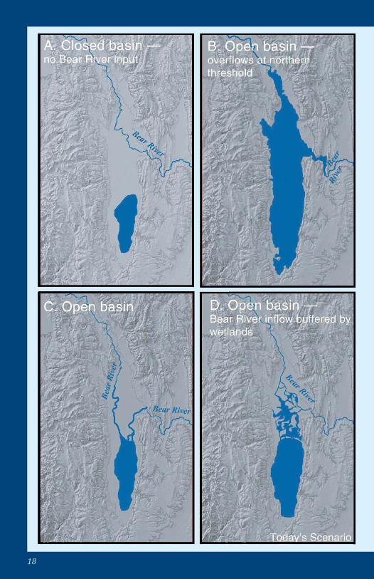
Throughout its history, Bear Lake has alternated between a closed- basin lake (A—water does not flow out) and an open-basin lake (B, C, and D—water flows both in and out) connected to the Bear River. Scenario A, Closed Basin; Bear Lake is a topographically closed basin isolated from the Bear River. Scenario B, Open Basin; Bear Lake enlarges, probably due to a wetter and colder climate. The lake can extend to 50 miles in length, spanning the entire Bear Lake Valley, until it overflows at the northern threshold (elevation and location of threshold may change over time). Scenario C, Open Basin; the Bear River’s channel migrates southward and reaches the lake. Scenario D, Open Basin; the Bear River water enters the lake indirectly through marshes or wetlands. In Scenario D the wetlands act as a filter, curbing the influence of the Bear River on lake water chemistry and lake-bottom sediments, which is today’s scenario. Figure adapted from Geological Society of America Special Paper 450.
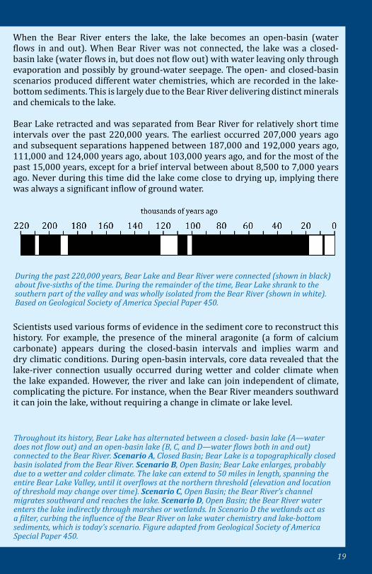
During the past 220,000 years, Bear Lake and Bear River were connected (shown in black) about five-sixths of the time. During the remainder of the time, Bear Lake shrank to the southern part of the valley and was wholly isolated from the Bear River (shown in white). Based on Geological Society of America Special Paper 450.
When the Bear River enters the lake, the lake becomes an open-basin (water flows in and out). When Bear River was not connected, the lake was a closed-basin lake (water flows in, but does not flow out) with water leaving only through evaporation and possibly by ground-water seepage. The open- and closed-basin scenarios produced different water chemistries, which are recorded in the lake-bottom sediments. This is largely due to the Bear River delivering distinct minerals and chemicals to the lake.
Bear Lake retracted and was separated from Bear River for relatively short time intervals over the past 220,000 years. The earliest occurred 207,000 years ago and subsequent separations happened between 187,000 and 192,000 years ago, 111,000 and 124,000 years ago, about 103,000 years ago, and for the most of the past 15,000 years, except for a brief interval between about 8,500 to 7,000 years ago. Never during this time did the lake come close to drying up, implying there was always a significant inflow of ground water.
Scientists used various forms of evidence in the sediment core to reconstruct this history. For example, the presence of the mineral aragonite (a form of calcium carbonate) appears during the closed-basin intervals and implies warm and dry climatic conditions. During open-basin intervals, core data revealed that the lake-river connection usually occurred during wetter and colder climate when the lake expanded. However, the river and lake can join independent of climate, complicating the picture. For instance, when the Bear River meanders southward it can join the lake, without requiring a change in climate or lake level.
20
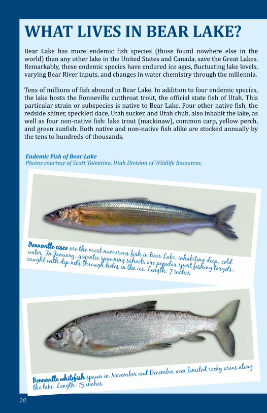
Endemic Fish of Bear Lake Photos courtesy of Scott Tolentino, Utah Division of Wildlife Resources.
WHAT LIVES IN BEAR LAKE?Bear Lake has more endemic fish species (those found nowhere else in the world) than any other lake in the United States and Canada, save the Great Lakes. Remarkably, these endemic species have endured ice ages, fluctuating lake levels, varying Bear River inputs, and changes in water chemistry through the millennia.
Tens of millions of fish abound in Bear Lake. In addition to four endemic species, the lake hosts the Bonneville cutthroat trout, the official state fish of Utah. This particular strain or subspecies is native to Bear Lake. Four other native fish, the redside shiner, speckled dace, Utah sucker, and Utah chub, also inhabit the lake, as well as four non-native fish: lake trout (mackinaw), common carp, yellow perch, and green sunfish. Both native and non-native fish alike are stocked annually by the tens to hundreds of thousands.
Bonneville cisco are the most numerous fish in Bear Lake, inhabiting deep, cold water. In January, gigantic spawning schools are popular sport fishing targets, caught with dip nets through holes in the ice. Length: 7 inches
Bonneville whitefish spawn in November and December over limited rocky areas along
the lake. Length: 15 inches

21
In the lake’s sediment are non-biting midge larvae (bright red tiny worm-like insects), ostracodes, and several varieties of worms that are the staple food of many small fish. Crayfish, scuds or side-swimmers, aquatic mites, and aquatic insect nymphs (mayflies, caddisflies, dragonflies, and damselflies) also live on the lake floor, on plants, and within the water.
Of the few submerged plants that live in Bear Lake, common ones include pondweed, coontail, and stonewort (so called because the plant becomes encrusted with lime). In Dingle Swamp and along the shores of Bear Lake, cattails, rushes, grasses, and sedges or bulrushes are common emergent (their leaves are above water) aquatic plants. Other emergent aquatic plants include water milfoil, carnivorous bladderwort, and water knotweed. An invasive plant, Phragmites (common reed), is found along many stretches of Bear Lake’s shoreline.
Bear Lake whitefish inhabit cold, deep waters of the lake, spawning from January to
May in deeper waters. Length: 9 inches
Bear Lake sculpin usually live in the deep water near the lake bottom. The small sculpin are an important food item for larger fish, especially the trout. There are about 3 to 9 million of these fish in the lake, typically outnumbering the combined human population of Utah and Idaho. Length: 6 inches
22
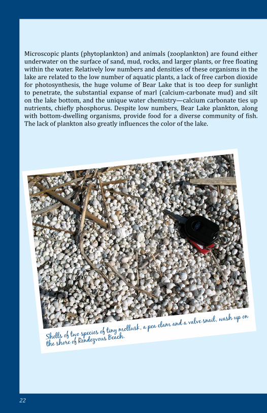
Shells of two species of tiny mollusk, a pea clam and a valve snail, wash up on
the shore of Rendezvous Beach.
Microscopic plants (phytoplankton) and animals (zooplankton) are found either underwater on the surface of sand, mud, rocks, and larger plants, or free floating within the water. Relatively low numbers and densities of these organisms in the lake are related to the low number of aquatic plants, a lack of free carbon dioxide for photosynthesis, the huge volume of Bear Lake that is too deep for sunlight to penetrate, the substantial expanse of marl (calcium-carbonate mud) and silt on the lake bottom, and the unique water chemistry—calcium carbonate ties up nutrients, chiefly phosphorus. Despite low numbers, Bear Lake plankton, along with bottom-dwelling organisms, provide food for a diverse community of fish. The lack of plankton also greatly influences the color of the lake.
23
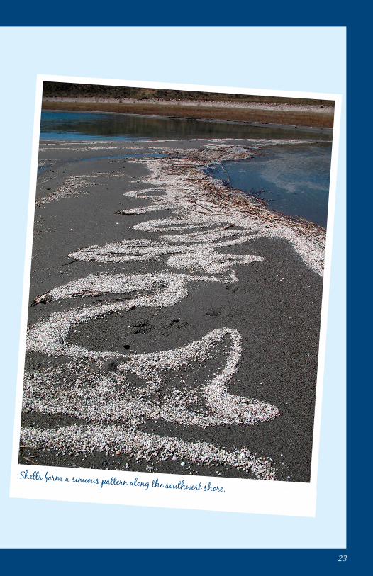
Shells form a sinuous pattern along the southwest shore.
24
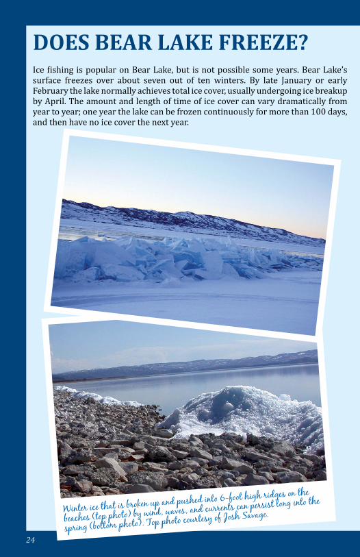
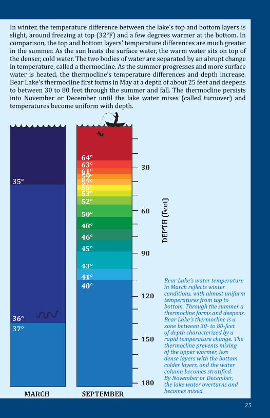
DOES BEAR LAKE FREEZE?Ice fishing is popular on Bear Lake, but is not possible some years. Bear Lake’s surface freezes over about seven out of ten winters. By late January or early February the lake normally achieves total ice cover, usually undergoing ice breakup by April. The amount and length of time of ice cover can vary dramatically from year to year; one year the lake can be frozen continuously for more than 100 days, and then have no ice cover the next year.
Winter ice that is broken up and pushed into 6-foot high ridges on the
beaches (top photo) by wind, waves, and currents can persist long into the
spring (bottom photo). Top photo courtesy of Josh Savage.
25
Bear Lake’s water temperature in March reflects winter conditions, with almost uniform temperatures from top to bottom. Through the summer a thermocline forms and deepens. Bear Lake’s thermocline is a zone between 30- to 80-feet of depth characterized by a rapid temperature change. The thermocline prevents mixing of the upper warmer, less dense layers with the bottom colder layers, and the water column becomes stratified. By November or December, the lake water overturns and becomes mixed.
In winter, the temperature difference between the lake’s top and bottom layers is slight, around freezing at top (32°F) and a few degrees warmer at the bottom. In comparison, the top and bottom layers’ temperature differences are much greater in the summer. As the sun heats the surface water, the warm water sits on top of the denser, cold water. The two bodies of water are separated by an abrupt change in temperature, called a thermocline. As the summer progresses and more surface water is heated, the thermocline’s temperature differences and depth increase. Bear Lake’s thermocline first forms in May at a depth of about 25 feet and deepens to between 30 to 80 feet through the summer and fall. The thermocline persists into November or December until the lake water mixes (called turnover) and temperatures become uniform with depth.
26
WHAT IS THE WEATHER AT BEAR LAKE? Annual temperatures at Laketown at the southern edge of Bear Lake have ranged from a record low of -37°F to a record high of 99°F. Wide ranging temperatures, which also occur on a daily basis, are due to the high elevation (the lake is at nearly 6,000 feet), and a dry, semi-arid, continental type climate. Temperatures on an average summer day range 30°F or more, from nearly 50°F at dawn to the lower 80s on July afternoons. These cool nighttime summer temperatures are favorable for growing raspberries, currants, and vegetables, giving Garden City its name. Daily winter temperature ranges are typically less than in summer, about 20°F—from 12°F to 32°F on an average January day.
The coldest temperature recorded in Utah (-69.3°F) and the second coldest temperature measured in the contiguous United States occurred at Peter Sinks in the Bear River Range about 7 miles west of Bear Lake, elevation 8,164 feet. Peter Sinks is one of many sinkholes in the Bear River Range, formed by water dissolving the limestone [see What is Karst?], resulting in circular impressions stamped on the landscape (popular snowmobiling areas because of the absence of trees). Because cold air is so effectively pooled and trapped in these topographic depressions, temperatures can be frigid any time of year—one June day recorded a temperature of only 3°F. Also, daily temperature changes in Peter Sinks can be astonishing—climbing 79°F, from -46°F to 33°F in just 4 ½ hours!
Precipitation averages a little more than one inch a month. However, snowfall amounts seem more impressive; December and January typically receive 12 inches of snow each. Summer precipitation is generated from moist air masses coming from the south, and scattered thunderstorms are the norm. Westward moving winter snowstorms from the Pacific Ocean dump snow in the Bear River Range, but lesser amounts reach the Bear Lake Valley because of its position on the leeward side of the Range, where air masses descend, compress, and dry.
27
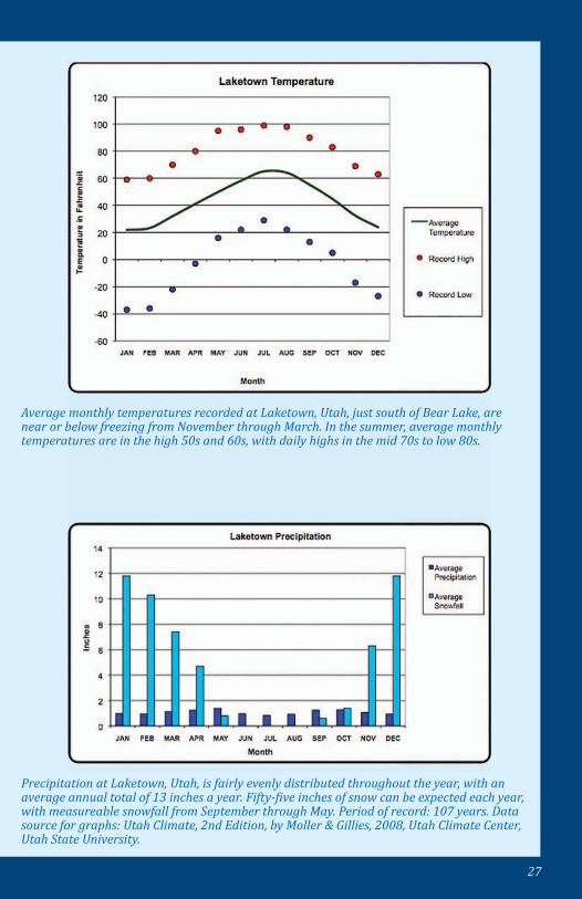
Average monthly temperatures recorded at Laketown, Utah, just south of Bear Lake, are near or below freezing from November through March. In the summer, average monthly temperatures are in the high 50s and 60s, with daily highs in the mid 70s to low 80s.
Precipitation at Laketown, Utah, is fairly evenly distributed throughout the year, with an average annual total of 13 inches a year. Fifty-five inches of snow can be expected each year, with measureable snowfall from September through May. Period of record: 107 years. Data source for graphs: Utah Climate, 2nd Edition, by Moller & Gillies, 2008, Utah Climate Center, Utah State University.
28
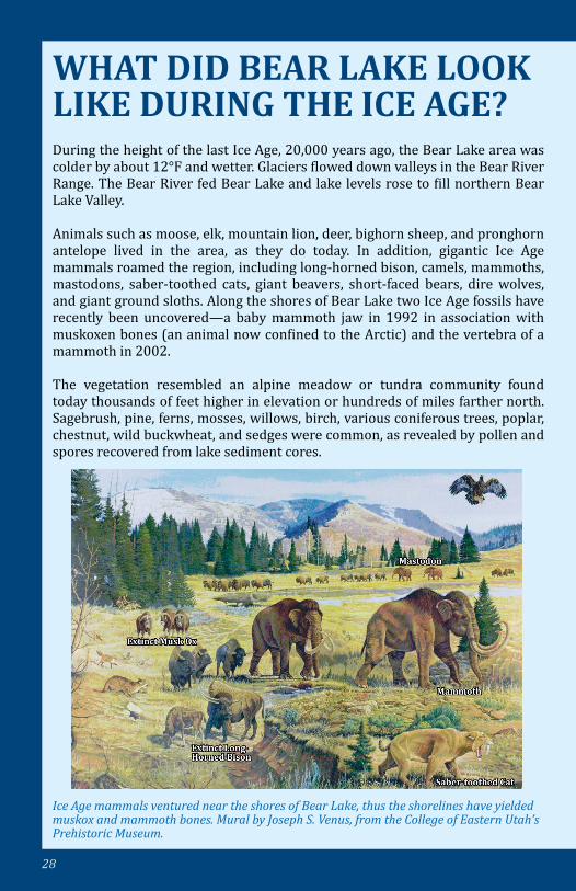
WHAT DID BEAR LAKE LOOK LIKE DURING THE ICE AGE?During the height of the last Ice Age, 20,000 years ago, the Bear Lake area was colder by about 12°F and wetter. Glaciers flowed down valleys in the Bear River Range. The Bear River fed Bear Lake and lake levels rose to fill northern Bear Lake Valley.
Animals such as moose, elk, mountain lion, deer, bighorn sheep, and pronghorn antelope lived in the area, as they do today. In addition, gigantic Ice Age mammals roamed the region, including long-horned bison, camels, mammoths, mastodons, saber-toothed cats, giant beavers, short-faced bears, dire wolves, and giant ground sloths. Along the shores of Bear Lake two Ice Age fossils have recently been uncovered—a baby mammoth jaw in 1992 in association with muskoxen bones (an animal now confined to the Arctic) and the vertebra of a mammoth in 2002.
The vegetation resembled an alpine meadow or tundra community found today thousands of feet higher in elevation or hundreds of miles farther north. Sagebrush, pine, ferns, mosses, willows, birch, various coniferous trees, poplar, chestnut, wild buckwheat, and sedges were common, as revealed by pollen and spores recovered from lake sediment cores.
Ice Age mammals ventured near the shores of Bear Lake, thus the shorelines have yielded muskox and mammoth bones. Mural by Joseph S. Venus, from the College of Eastern Utah’s Prehistoric Museum.
29
WHAT DID BEAR LAKE LOOK LIKE DURING THE ICE AGE?
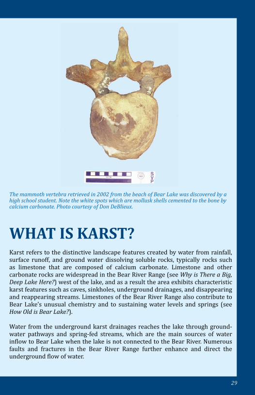
The mammoth vertebra retrieved in 2002 from the beach of Bear Lake was discovered by a high school student. Note the white spots which are mollusk shells cemented to the bone by calcium carbonate. Photo courtesy of Don DeBlieux.
WHAT IS KARST?Karst refers to the distinctive landscape features created by water from rainfall, surface runoff, and ground water dissolving soluble rocks, typically rocks such as limestone that are composed of calcium carbonate. Limestone and other carbonate rocks are widespread in the Bear River Range (see Why is There a Big, Deep Lake Here?) west of the lake, and as a result the area exhibits characteristic karst features such as caves, sinkholes, underground drainages, and disappearing and reappearing streams. Limestones of the Bear River Range also contribute to Bear Lake’s unusual chemistry and to sustaining water levels and springs (see How Old is Bear Lake?).
Water from the underground karst drainages reaches the lake through ground-water pathways and spring-fed streams, which are the main sources of water inflow to Bear Lake when the lake is not connected to the Bear River. Numerous faults and fractures in the Bear River Range further enhance and direct the underground flow of water.
30
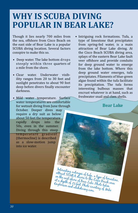
Though it lies nearly 700 miles from the sea, offshore from Cisco Beach on the east side of Bear Lake is a popular SCUBA diving location. Several factors conspire to make this so.
• Deep water. The lake bottom drops steeply within three quarters of a mile from the shore.
• Clear water. Underwater visib-ility ranges from 20 to 30 feet and sunlight penetrates to about 90 feet deep before divers finally encounter darkness.
• Mild water temperature. Surface water temperatures are comfortable for wetsuit diving from June through October. Deeper dives may require a dry suit as below about 50 feet the temperature rapidly drops into the 50s, even in the summer. Diving through this steep temperature gradient (thermocline) is described as a slow-motion jump into ice water.
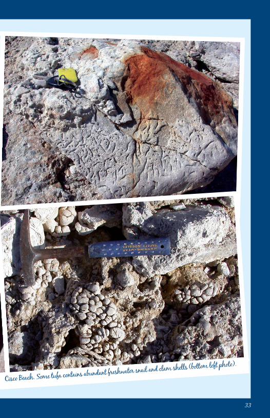
• Intriguing rock formations. Tufa, a type of limestone that precipitates from spring-fed water, is a main attraction of Bear Lake diving. At the Cisco Beach SCUBA diving area, splays of the eastern Bear Lake fault veer offshore and provide conduits for deep ground water to emerge from the lake bottom. Where this deep ground water emerges, tufa precipitates. Filaments of blue-green algae found within the tufa facilitate its precipitation. The tufa forms interesting bulbous masses that encrust whatever is at hand, such as freshwater snail and clam shells.
WHY IS SCUBA DIVING POPULAR IN BEAR LAKE?
Interesting outcrops of tufa, a type of limestone,
attract SCUBA divers to the Cisco Beach area
on the east shore of Bear Lake. Photo taken at a depth of 25 feet. Photo courtesy of Mike
Engberson and utahdiving.com.
31
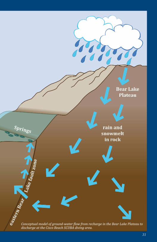
Conceptual model of ground-water flow from recharge in the Bear Lake Plateau to discharge at the Cisco Beach SCUBA diving area.
32
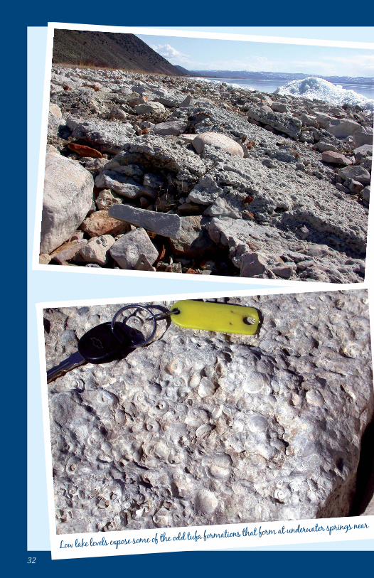
Low lake levels expose some of the odd tufa formations that form at underwater springs near Cisco Beach. Some tufa contains abundant freshwater snail and clam shells (bottom left photo).
33
Low lake levels expose some of the odd tufa formations that form at underwater springs near Cisco Beach. Some tufa contains abundant freshwater snail and clam shells (bottom left photo).
34
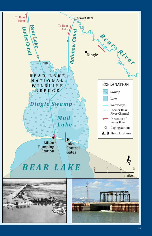
HOW HAVE PEOPLE MODIFIED BEAR LAKE?The greatest modification to the lake occurred between 1911 and 1917, when a canal system and a pump station were constructed to divert the Bear River into Bear Lake. In historical times, Bear River water probably first entered Bear Lake in 1912. Since then, the lake has been a water-storage reservoir. The reservoir water (the upper 21 feet of the lake and coincidentally 21% of the volume of the lake at the maximum lake level of 5923.65 feet) is used mainly to store spring runoff to use for late season irrigation and for power generation.
The canal system was finished by Utah Power and Light (now PacifiCorp). The diversion of the river starts at Stewart Dam, where the river is channeled southward into the Rainbow Canal, through Dingle Swamp and Mud Lake, and then into northern Bear Lake. Bear Lake water, when needed, can then be pumped out through the Lifton pumping station where it is returned to the Bear River through the Bear Lake Outlet Canal. The outlet canal roughly follows natural, ancient stream courses that flowed occasionally when Bear Lake topped the north shore sand bar and spilled out into Bear Lake Valley and to the Bear River. A small dam on the outlet canal keeps the water level of Mud Lake high to enhance waterfowl habitat at the 19,000-acre Bear Lake National Wildlife Refuge (especially for Canada geese, redhead and canvasback ducks, and trumpeter swans).
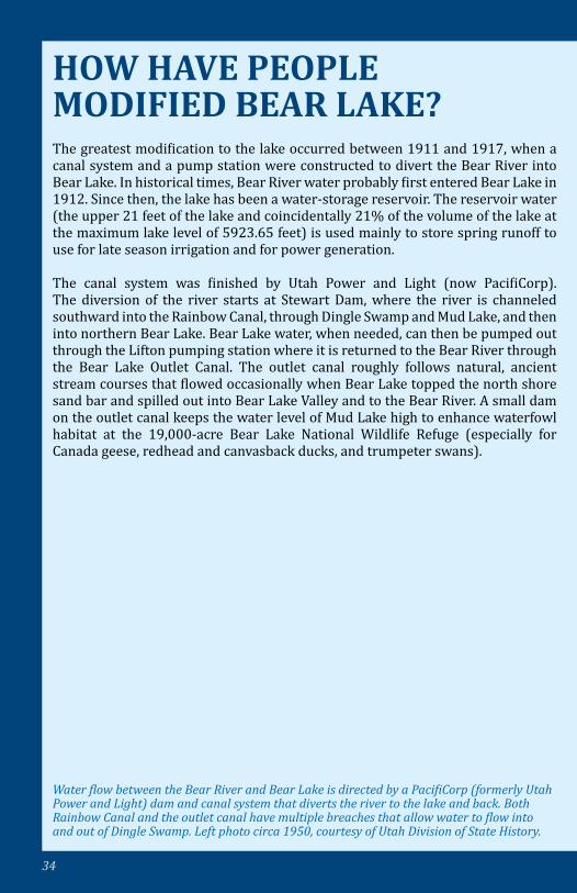
Water flow between the Bear River and Bear Lake is directed by a PacifiCorp (formerly Utah Power and Light) dam and canal system that diverts the river to the lake and back. Both Rainbow Canal and the outlet canal have multiple breaches that allow water to flow into and out of Dingle Swamp. Left photo circa 1950, courtesy of Utah Division of State History.
35
EXPLANATION
Swamp
Lake
Waterways
Gaging station
Photo locations
Former Bear River ChannelDirection of water �low
A, B
To Bear River
To Bear Lake
Stewart Dam
Dam
B e a r R i v e rRai
nbo
w C
anal
Bear Lake
Outlet Canal Dingle
Dingle Swamp
M u d L a k e
B E A R L A K E N A T I O N A LW I L D L I F E
R E F U G E
B E A R L A K E
BALifton
Pumping Station
Inlet Control Gates
N0 1 2 3
miles
36
WHY IS THE LAKE SO LOW OR WHY IS IT SO HIGH?Today the Bear Lake reservoir is operated primarily for irrigation and flood control (see How Have People Modified Bear Lake?). So the short answer is, when the lake rises in the spring, water is stored to avoid flooding downstream. The lake lowers as irrigation water is needed downstream in the summer and fall. The lake can be further lowered in the winter if a need for additional spring storage capacity is anticipated due to high snowpack.
The Bear Lake reservoir has a yearly average fluctuation of about 3.5 feet. Consecutive years of drought or deluge can greatly lower or raise the lake, to a maximum of 5923.65 feet (legal limit), set multiple times, and a minimum 5902 feet, set on November 14th, 1935.
WHAT IS THE“LAW OF THE LAKE”?The laws and regulations governing the use of Bear Lake as a reservoir arose about 100 years ago out of negotiations between Utah Power and Light and the Bear River Canal Company. At that time the power company diverted the Bear River to Bear Lake for storage related to hydropower generation (see How Have People Modified Bear Lake?), and groups of downstream farmers and their crop irrigation companies also started building dams and canals to divert the Bear River. Thus conflicts arose between the power company and downstream irrigation companies. To resolve the conflicts, Utah Power and Light entered into a contract with the Bear River Canal Company assuring the canal company of irrigation water. Other contracts with other canal companies soon followed, and the “Law of the Lake” grew.
These early contracts prompted the power company to acquire state water rights in an effort to protect its ability to generate hydropower. Court decrees recognized these water rights and established that the power company had the right to divert all of the water in the Bear River at Stewart Dam and to release water from Bear Lake to generate power as long as it met its contracts with canal companies. It could fill the reservoir in the upper lake all the way to 5923.65 feet above sea level or drain it all the way down to the bottom of its pumps at 5902 feet.
At first, there was plenty of water to meet the power company’s and all irrigation needs, but in the 1930s a series of dry years led to water shortages all along the Bear River, upstream and downstream of Bear Lake. The shortages were not fully addressed until 1958 when the three states through which the river flows, Idaho,
37
The bed of Bear Lake is held in trust by the states of Idaho and Utah. With statehoods in 1890 and 1896, Idaho and Utah, respectively, acquired all land lying below the ordinary high water mark of navigable rivers and lakes. Known as “sovereign lands,” these lands and their resources are held in trust for the use and enjoyment of the public. Bear Lake’s high water mark is generally recognized to be 5,923.65 feet above sea level (see What is the Law of the Lake?). All land below this level is state sovereign land managed by the Idaho Department of Land’s Navigable Waters Program (NWP) and by the Utah Division of Forestry, Fire, and State Lands (FFSL).
For further information on Idaho’s NWP and Bear Lake, see http://www.idl.idaho.gov/bureau/smr/navwaters/nw_index.htm.
For further information on Utah’s Bear Lake management, goals, and objectives, as well as implementation strategies for future resource management, see http://www.forestry.utah.gov/sovlands/bearlake.php, which includes the Bear Lake Comprehensive Management Plan that was approved by FFSL in 2009.
WHO OWNS THE LAKE BED?
Utah, and Wyoming, agreed on a compact regulating the use of Bear River water and Bear Lake. This Bear River Compact is a sort of super “Law of the Lake” signed as three state laws and federal law. This compact, which has been amended once, includes a provision that the power company cannot lower the lake below 5914.6 feet unless water is released for irrigation needs.
Due to flooding downstream of the lake in 1983 and 1984, courts mandated the power company to release water when the lake level is high and the upstream snow pack is great, so as to provide storage for flood prevention. Most recently, the power company and irrigation companies have entered into settlement agreements with area homeowners who want the lake held as high as practical (which makes for better beaches and shore-side recreation).
Now the power company releases water only for downstream irrigation use or flood control. It generates power only when water is released for these two purposes. Water has not been released solely for power generation for many years. The “Law of the Lake” has governed and evolved for more than 100 years. One might expect it will change some more in its second century.
38
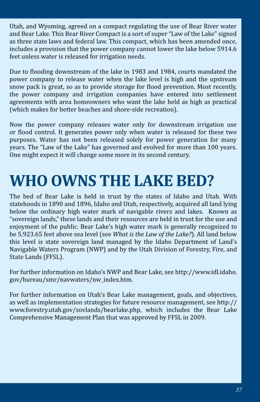
BEAR BITES
Lake TypeNatural freshwater lake occupying an active tectonic depression; upper 21% of lake is a reservoir for the Bear River since 1912
Surface Area 110 square miles at maximum lake elevation
Water Volume 6,550,871 acre-feet (1.94 cubic miles)
Reservoir
Top 21.65 feet can be drawn off or 21% of volume (average annual fluctuation of 3.2 feet); reservoir used for irrigation, hydropower, and flood control. Reservoir storage capacity: 1,421,000 acre feet
Lake Elevation Maximum of 5,923.65 feet above sea level; historic minimum of 5902.00 in1935
Maximum Depth 208 feet
Average Depth 94 feet
Maximum Length 18.8 miles
Maximum Width 7.4 miles
Shoreline Length 48 miles
Age of Lake 500,000 to 6,000,000 years old; one of the oldest lakes in North America
Water Temperature
Typical annual range is from ~ 32°F (freezing) to 69°F; 73°F record high
39
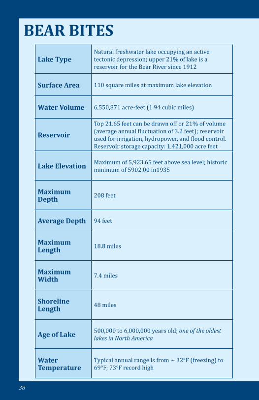
pH 8.2–8.8 (alkaline)
Dominate Ions Bicarbonate (HCO3), Sulfate (SO4), Magnesium (Mg), Chloride (Cl), Sodium (Na), and Calcium (Ca)
Transparency About 16 feet, ranges from 7 to 39 feet
Ice Cover Historically the lake has frozen over about 69% of winters
Former Names Black Bears Lake, Weaver’s Lake, Little Lake, Sweet Water Lake, Sweet Lake, Trout Lake
Lake MonsterEarly Shoshone legends told of a lake monster. Since 1868, historical accounts call it the Bear Lake Monster
State Parks
Idaho: Bear Lake State Park – North Beach and East Beach. Utah: Bear Lake State Park – Marina, North Eden, Rainbow Cove, Cisco Beach, South Eden, First Point, and Rendezvous Beach
National Wildlife Refuge
Bear Lake National Wildlife Refuge; nearly 30 square miles of marsh (Dingle Swamp), open water (Mud Lake) and grassland habitat
Flags over Bear Lake since 1819
Spain, Mexico, United Kingdom, and United States (Oregon Territory, Utah Territory, Idaho Territory, and the states of Utah and Idaho)
40
41
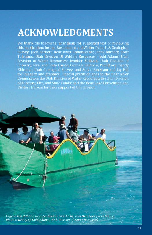
ACKNOWLEDGMENTSWe thank the following individuals for suggested text or reviewing this publication: Joseph Rosenbaum and Walter Dean, U.S. Geological Survey; Jack Barnett, Bear River Commission; Jenny Barnett; Scott Tolentino, Utah Division Of Wildlife Resources; Todd Adams, Utah Division of Water Resources; Jennifer Sullivan, Utah Division of Forestry, Fire, and State Lands; Connely Baldwin, PacifiCorp; Sandy Eldredge, Utah Geological Survey; and Stevie Emerson and Jay Hill for imagery and graphics. Special gratitude goes to the Bear River Commission; the Utah Division of Water Resources; the Utah Division of Forestry, Fire, and State Lands; and the Bear Lake Convention and Visitors Bureau for their support of this project.
Legend has it that a monster lives in Bear Lake. Scientists have yet to find it. Photo courtesy of Todd Adams, Utah Division of Water Resources
Public Information Series 96Utah Geological Surveya division ofDepartment of Natural Resources2011