Embed Size (px)
Citation preview

West Perth Regeneration MasterplanAugust 2008 | JCY0748
Mid block Internal View

PAGE 2
P2 - JCY architects and urban designers West Perth Regeneration Masterplan 0748
Revision Date RecipientREV A 02-10-08 Town Of Vincent
contents
1.0 Introduction 1.1 Executive Summary 1.2 Introduction
2.0 Site Analysis 2.1 Background Information 2.2 Site Appearance 2.3 Appearance 2.4 Current Planning Controls 2.5 Surrounding Context 2.6 Current Land Use 2.7 Heritage
3.0 Masterplan 3.1 Option 1 3.2 Option 2 3.3 Activated Pedestrian Spine 3.4.1 Current Movement 3.4.2 Proposed Movement 3.4.3 Movement & Car Parking 3.5 Safety and Security
4.0 Implementation 4.1 Feasibility Assessment 4.2 Incentives to Develop 4.3 Developer Contribution 4.4 Traffic Analysis 4.5 Planning Considerations
5.0 Appendix 5.1 SKM Traffic Report 5.2 Leederville Extension Report
Cleaver Street

PAGE 3
P3 - JCY architects and urban designers West Perth Regeneration Masterplan 0748
1.1 Executive Summary
Since the Town of Vincent commissioned their Leederville Town Centre Master Plan in 2005, they have embraced the challenges
facing all inner-city councils, to:
• Encourage the introduction of centralised high density residential
• To provide additional workplaces and employment opportunities
• To capitalise on transit infrastructure, and
• To ensure every development scenario is of best practice sustainable design.
While accepting these higher order goals, the Town of Vincent has been at pains not to lose the intrinsic qualities and sense of
place that make Leederville and its surrounds such an attractive place to live, work and visit.
The extension of the Leederville Master plan studies to encompass the subject of this report, the West Perth Regeneration Area,
signifies the Town of Vincent’s commitment to urban renewal on the northern fringe of Perth’s CBD.
The nine hectares of land has the capacity to provide an additional 80,000m2 of commercial offices, and between 600 and 800
residential apartments. The proposed density will sustain a local retail offer that will allow future residents to walk to local food
and café outlets, while also having the option of an 8 minute walk to the café strip of Oxford Street.
This study recommends the construction of a foot bridge at the southern end of Cleaver Street, which will provide pedestrians
and cycle connective over the combined rail and free way barrier, to the City West and West Perth. This link will join Beatty Park
and Kings Park as a dynamic activated pedestrian spine.
This report also suggests a Cleaver Street train station that while does not figure on Perth Transit Authorities future plan, gained
tacit approval from some members of the Department for Planning and Infrastructure.
The West Perth Regeneration Area represents one of the best opportunities to achieve the density increase to Perth’s inner ring
from 8000 to 25000 residence by 2031.
Newcastle Street

1.0 PAGE 4
P4 - JCY architects and urban designers West Perth Regeneration Masterplan 0748
Perth Aerial showing Site Area
1.0 introduction
1.1 Introduction
The West Perth Regeneration study is for an area of land of some
19.3 hectares bounded by Newcastle Street to the North, the
Mitchell Freeway to the South, Loftus Street to the West and Charles
Street to the East.
The land was ceded to the Town of Vincent from the City of Perth
on July 1st 2007. Its current use is predominantly light industrial,
with some showroom and office uses on Newcastle Street.
Its largest land holding is a vehicle showroom, while a number of
affiliated automotive industries all located in the area.
The Town of Vincent commissioned this report to extend the urban
renewal of the Leederville Town Centre to include this portion of
land.
The West Perth Regeneration Area is part of a large precinct that
includes Oxford Close, City West and the Water Corporation that all
abound Loftus Street and the Mitchell Freeway while this area spans
the Towns of Vincent and Cambridge and the City of Perth, together
it represents over 50 hectares of inner city land that has an extremely
low resident population, and a relatively low commercial yield.
The future development of all this land will have a significant impact
on traffic on both Loftus and Newcastle Streets, and this study
should be read as the first step in a larger co-ordinated study.
ScopeThis study will comment on:
• Appearance and Character
• Land Use
• Heritage Issues
• Capacity and Movement
• Safety and Security
• Feasibility and,
• Implementation
1
“...a vibrant, contemporary
place for living, working
and doing business”.
2
3
4
5
6
7
8
9
Key1. Oxford St Entertainment Precinct
2. Beatty Park
3. City West Station
4. City West Retail Precinct
5. Harbour Town
6. Perth Station
7. St Georges Tce
8. Convention Centre
9. Kings Park

2.0 PAGE 5
P5 - JCY architects and urban designers West Perth Regeneration Masterplan 0748
2.1 Background InformationPreceding Studies
1. The Leederville MasterplanThe Leederville Masterplan, within the Town of Vincent, aims to increase the density of the area while maintaining and increasing the mix of uses and the
‘village atmosphere’ of the area. The aim of the masterplan is to create;
· A place with its own identity
· A place with living streets and an interactive public forum
· A welcoming place with variety and choice
· A place that makes good use of its resources
· The best use of Transit Oriented Development principles for a highly connected place.
2. City WestSouth of the West Perth Regeneration Study Area lies the City West retail precinct. With a large contiguous parcel with a single owner the area is currently being examined for redevelopment. The development is likely to contain a mix of retail and commercial with some residential dwellings included. The prime inner-city location of the site, with the City West train station adjacent, makes it an idae3wal location for a future high density mixed use development that adheres to TOD principles.
3. Southport Street/Oxford Close PrecinctThe parcel of land on the corner of Loftus and Newcastle streets is owned and occupied by the WA Water Corporation and is the subject of its own masterplan, independent to the Leederville Masterplan. The Water Corp masterplan retains the John Tonkin Water Centre and allows for new development along Newcastle Street. The Leederville Masterplan advocated an ‘icon’ tower on the corner of Loftus and Newcastle Streets and the Water Corporation Masterplan has retained the tower as a ‘future development option’
4. Southport Street and Oxford CloseThe area around Southport Street and Oxford Close, on Town of Cambridge land, has similar land uses to the West Perth Study area, with light industrial being the predominant use. The area, within 400m of the Leederville Train Station, is currently the subject of Department for Planning and Infrastructure and Town of Cambridge Urban Design Studies, which are being undertaken independently and have not been officially released at the time of writing this. It is anticipated that the area will be the subject.
5. Proposed Perth StadiumThe 60 000 seat multi-purpose Perth Stadium was recently unveiled by the WA State Government and is due for completion in 2016. In addition to the stadium, the plan involves new housing and transport infrastructure.
2.0 site analysis
1
2
3
4
Key
1. Leederville Masterplan
2. City West Redevelopment
3. Watercorp Site Masterplan
4. Oxford Close/Southport St
5. Perth Stadium
5

2.0 PAGE 6
P6 - JCY architects and urban designers West Perth Regeneration Masterplan 0748
2.2 Site Appearance
NEWCASTLE STREET
• Generally low density.
• No street trees or landscaping at the pedestrian level.
• Most buildings are set back from the street edge with car
parking in front of the site.
• Very vehicle oriented and not a pedestrian friendly
environment.
NEWCASTLE STREET (NORTHERN SIDE)
• Features a mix of uses but predominantly residential.
• Area is zoned R80 but mostly underdeveloped.
• Some heritage buildings + buildings of interest.
• Some street trees.
• Buildings setback from the street edge.
NEWCASTLE STREET (SOUTHERN SIDE)
• Predominantly automotive focused business’, with some
showrooms and offices.
• Mostly single storey.
• No protection for pedestrians.
• ‘patchwork’ footpath paving.
• No street trees.
• Vehicle parking often out the front of the business off
Newcastle Street.
CLEAVER ST AND SURROUNDING STREETS AND LANE WAYS.• The study area has a general ‘light industrial’ aesthetic, with
some showrooms and commercial business.
• The quality and density of built form is generally low.
• The predominant land use is light industrial.
OPEN SPACE
• The corner of Loftus St and Leederville Parade features a small public park.
• The park is cut off from the surrounding areas by busy roads and is difficult for pedestrians to access.
• The park is currently under-utilised.
• The land is owned by the Main Roads WA and the Department for Planning and Infrastructure.
SURROUNDING AREAS
• Pedestrian movement from the study area to the surrounding
locations is greatly hindered by the freeway, the Charles St
freeway offramp, the train line and Loftus Street.
2.0 site analysis
2.0 PAGE 7
P7 - JCY architects and urban designers West Perth Regeneration Masterplan 0748
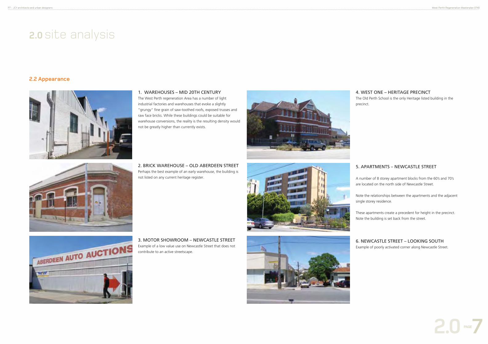
2.2 Appearance
2.0 site analysis
1. WAREHOUSES – MID 20TH CENTURY The West Perth regeneration Area has a number of light
industrial factories and warehouses that evoke a slightly
“grungy” fine grain of saw-toothed roofs, exposed trusses and
raw face bricks. While these buildings could be suitable for
warehouse conversions, the reality is the resulting density would
not be greatly higher than currently exists.
2. BRICK WAREHOUSE – OLD ABERDEEN STREETPerhaps the best example of an early warehouse, the building is
not listed on any current heritage register.
3. MOTOR SHOWROOM – NEWCASTLE STREETExample of a low value use on Newcastle Street that does not
contribute to an active streetscape.
4. WEST ONE – HERITAGE PRECINCTThe Old Perth School is the only Heritage listed building in the
precinct.
5. APARTMENTS – NEWCASTLE STREET
A number of 8 storey apartment blocks from the 60’s and 70’s
are located on the north side of Newcastle Street.
Note the relationships between the apartments and the adjacent
single storey residence.
These apartments create a precedent for height in the precinct.
Note the building is set back from the street.
6. NEWCASTLE STREET – LOOKING SOUTHExample of poorly activated corner along Newcastle Street.
2.0 PAGE 8
P8 - JCY architects and urban designers West Perth Regeneration Masterplan 0748
2.0 site analysis
Quarry Pt
TOWN OFVICTORIA
PARK
TOWN OF CAMBRIDGE
Kings Park
Kings Park is not within theCity of Perth municipality and as suchdoes not form part of this Scheme.It is administered by the Botanic Garden and Parks Authority.
EPRA - Area Subject to East Perth Redevelopment Act 1991
AVENUE
AVE
MACEY ST
CONSTITUTION ST
NILE STREET
TRINITY
NELSON CR
STREET
HAIG PARK
MULBERRY
WA
Y
CIR
CLE
WATERLOO CRES
CENT
HORA
TIO
ST
ST
REGAL PL
HA
LE
NELSONCR
STREETTERRACE
PLAI
N ST
REET
WICKHAM STREET
WITTENOOM
DRIVE
BRONTE STREET
FORREST
A
VE
EASTBROOK
JEW
ELL
VIC
TOR
IA
T
CE
SUMMERS ST
LAN
E
HENRY LAWSON WALK
OLD BELVIDERE PROM
BUNBURY CR
BUNBURY CR
TULLY RD
BEACON TCE
STOKES WAY REN
AISSA
NC
E AVE
STREET
STREET
PLAIN ST
BROOK ST
EAST
PA
RA
DE
BROWN
TULL
Y R
D
BENN
ETT
STRE
ETPL
AIN
STRE
ET
TERRACE
STREET
ROYAL
BENN
ETT
STRE
ET
BISHOPS ROWGODERICH STREET
WELLINGTON STREET
RIVERSIDE
STREET
BURT
WAY
WITTENOOM
MOORE ST
HILL
KENSINGTON
GLY
DE
S
T
SAUNDERS ST
SUMMERS ST
CHERITON ST
CLA
ISEB
RO
OK
R
D
CAVERSHAM ST
HE
NR
Y
ST
FIE
LDE
R S
TRE
ET
LORD
STR
EET
ROBE
RTSO
N S
T
GLAD
STON
E S
T
STREET
KIR
KST
ALL
GN
S
BROWN ST
EDWARD ST
LIM
E S
T
STREET
CLO
TILD
E
ST
NO
RB
ERT
ST
LOR
D
ROYAL
STRE
ET
NEWCASTLE STREET
MASQUE STREETBRAI
D ST
REET
STREETTUDORI STREET
PISC
ONER
I STR
EET
NASH
ST
MOORE ST
STRE
ETSTRE
ET
STRE
ET
GRE
GSO
N ST
REET
GRASSO STREET
PARRY
LIND
SAY
ST
JAMES STREET
STIR
LING
PIER
BEAU
FORT
ROE
STREET
STRE
ET
MUS
EUM
ST
STREET
VIA
TORR
E
LORD
STR
EET
VICTORIA SQ STRE
ET
ROAD
ADELAIDE
HILLVI
CTO
RIA
HAY
AVEN
UE
WELLINGTON STREET
IRW
IN
ST GEORGES TERRACE
TERRACE RDRIVERSIDE DRIVE
MURRAY STREET
GO
VERN
ORS
A
VEPI
ER
STRE
ETCA
THED
RAL
AVE
STRE
ET
HAY STREET MALL
FORR
EST
PLAC
E
THE ESPLANADE
BARR
ACKHO
WAR
D
ST
ST GEORGES TERRACE
STRE
ET
WIL
LIAM
STREET
WOLF LANE
SHER
WO
OD
CT
MOUNTS BAY ROAD
ERRI
CHET
TI P
LACE
WILLIA
M
ST
REET
FRANCIS STREET
STREET
NEWCASTLE
STRE
ET
JAMES STREET
STREET BURY
ST
NICK
S LA
NE
QUE
EN
ST
MOU
NTAI
N TC
ELA
KE
PALM
ERST
ON
PARK
ER
ST
STREET
KING
S
TREE
T
MER
CANT
ILE
LANE
ST GEORGES TERRACE
MIL
L
S
T
MIL
LIG
AN S
TREE
T
MURRAY
WELLINGTON STREET
SPRING ST
HAYELDE
RST
REET
TER
RA
CE
MALCOLM S
T
MIT
CHEL
L FR
EEW
AY
ROAD
MOUNT S
T
BAY
HARV
EST
CLIFF ST
PARLIAMENT PL
STREET
SERI
CHLA
NE
ABERDEEN
SHEN
TON
ST
MIL
LIGA
N S
T
STREET
FITZ
GERA
LD
S
TREE
T
JOHN
JAMES
ROE
STREET
STREET
GEO
RGE
ST
GO
LDIN
G
ST
OLD ABERDEEN PLACE
GO
RDO
N
ST
COO
LGAR
DIE
S
T
MARKET ST
RAILWAY PARADE
CLEA
VER
ST
LEEDERVILLE PROMENADE
SUTH
ERLA
ND
S
T
SUTHERLAND ST
TAND
Y S
T
DOUG
LAS
ST
PLAISTO
WE M
E
STREET
TROODE STLOFT
US
STR
EET
CO
LIN PL
STRE
ET
ROAD
BELL
EVUE
TCE
STDELHI
CO
LIN ST
CA
MPB
ELL ST
STRE
ET
THELMA STSTREET
LAW
RENC
E A
VE
STREET
WELLINGTON STREET
MAYFAIR
STREETCLIVE
PROWSE STWEST ST
HAVE
LOCKCOLIN GR
KINGS PARK ROAD
COLI
N
ALTO
NA
ST
STREET
MURRAY
STRE
ETCOOK ST
AVEN
UE
HAY
STREET
RICHARDSON
VENT
NOR
OUT
RAM
ORD
THOMASRHEOLA ST
WAL
KER
AVE
STREET
MO
UN
TS
ROAD
MOUNTS
BAY
KINGS PARK AVE
BAY
CRAWLEY
AVENUE
WINGFIELD AVE
AVE
HA
CK
ETT
DR
MOUNTS
PARK
AV
EN
UE
THO
MAS
STREET
WIN
THR
OP
Cove
Claisebrook
Pt Fraser
Perth Water
SWAN RIVER
The Narrows
Pt Lewis
Matilda Bay
VictoriaGardens
Gloucester ParkRacewayW.A.T.A.
MardalupPark
Island
Heirisson
CITY OF SOUTH PERTH
Claisebrook
W.A.C.A.Queens Gardens
LangleyPark
McIver
WellingtonSquare
St Mary'sCathedral
Government House
GPOCity
TownHall
Supreme CourtGardens
StirlingGardens
WeldSquare
RussellSquare
Bus Station
Busport
EntertainmentCentre
The Esplanade
TOWN OF VINCENT
BarrackSquare
CityWest
Harold BoasGardens
ParliamentHouse
Mt Eliza
TotterdellPark
EPRA
2nono
plot ratio planplot ratio plan
2002004City Planning SchemeCity Planning Scheme
Not to scale
This plan forms part of the Scheme text and should be consulted in conjunction with the Plot Ratio Policy. In addition it may be necessary to refer to the relevant precinct plan.
Municipal Boundary
East Perth Redevelopment Area Boundary
PLOT RATIO
1.0 : 1.0
2.0 : 1.0
3.0 : 1.0
4.0 : 1.0
5.0 : 1.0
Refer to Specific Plot Ratio Requirements
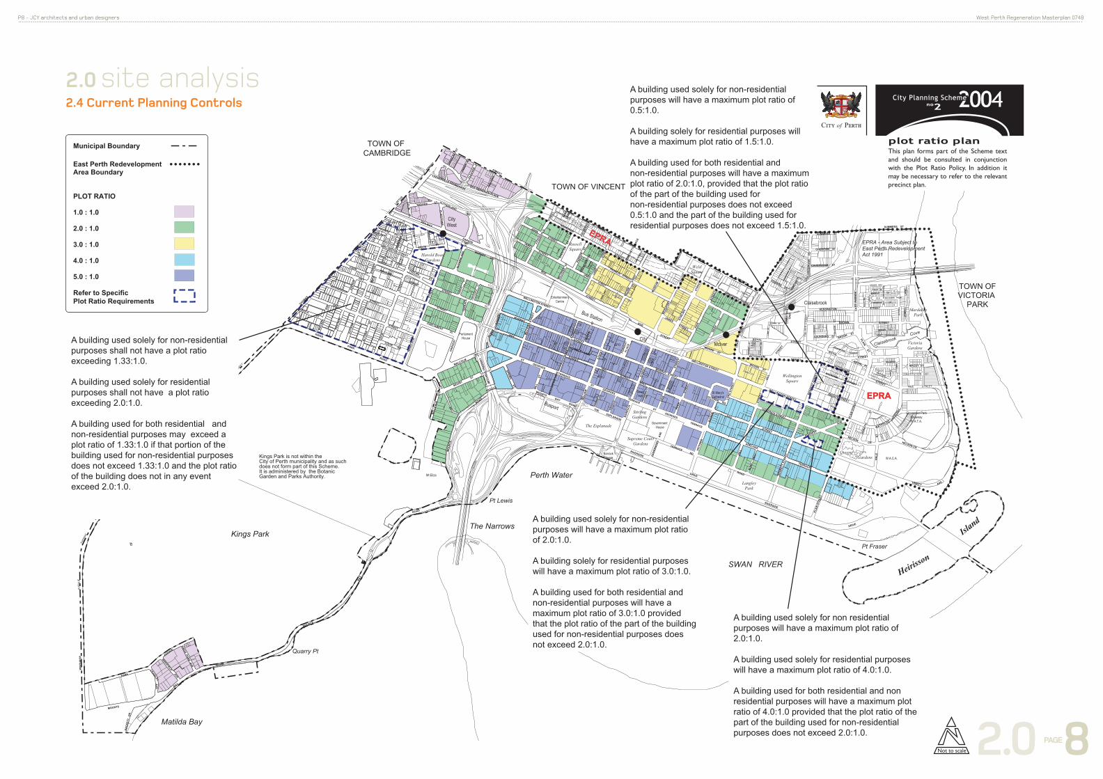
A building used solely for non-residential purposes shall not have a plot ratio exceeding 1.33:1.0.
A building used solely for residential purposes shall not have a plot ratio exceeding 2.0:1.0.
A building used for both residential and non-residential purposes may exceed a plot ratio of 1.33:1.0 if that portion of the building used for non-residential purposes does not exceed 1.33:1.0 and the plot ratio of the building does not in any event exceed 2.0:1.0.
A building used solely for non-residential purposes will have a maximum plot ratio of 0.5:1.0.
A building solely for residential purposes will have a maximum plot ratio of 1.5:1.0.
A building used for both residential and non-residential purposes will have a maximum plot ratio of 2.0:1.0, provided that the plot ratio of the part of the building used for non-residential purposes does not exceed 0.5:1.0 and the part of the building used for residential purposes does not exceed 1.5:1.0.
EPRA
EPRA
A building used solely for non residential purposes will have a maximum plot ratio of 2.0:1.0.
A building used solely for residential purposes will have a maximum plot ratio of 4.0:1.0.
A building used for both residential and non residential purposes will have a maximum plot ratio of 4.0:1.0 provided that the plot ratio of the part of the building used for non-residential purposes does not exceed 2.0:1.0.
A building used solely for non-residential purposes will have a maximum plot ratio of 2.0:1.0.
A building solely for residential purposes will have a maximum plot ratio of 3.0:1.0.
A building used for both residential and non-residential purposes will have a maximum plot ratio of 3.0:1.0 provided that the plot ratio of the part of the building used for non-residential purposes does not exceed 2.0:1.0.
2.4 Current Planning Controls
2.0 PAGE 9
P9 - JCY architects and urban designers West Perth Regeneration Masterplan 0748
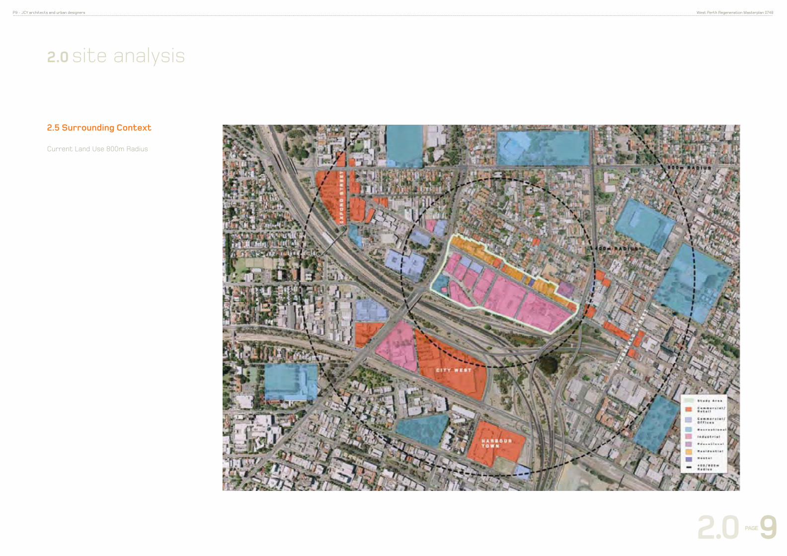
2.5 Surrounding Context
Current Land Use 800m Radius
2.0 site analysis

2.0 PAGE 10
P10 - JCY architects and urban designers West Perth Regeneration Masterplan 0748
2.6 Current Land Use 400m Radius
• The predominant land use is light industrial + showrooms
• The limited residential component is generally low density
and restricted to the northern side of Newcastle Street
• The largest occupant of the study area is a motor vehicle
dealership, located on the corner of Newcastle and Charles
Streets.
2.0 site analysis
4911,60023645Grand Total
5211,091 21240Sub Total
0872 05Vacant Floor Area
702,068 305Storage
98196 22Shop
704,347 6310Service Industry
54190 42Retail
282,878 10114Office / Business
40540 142Manufacturing
sqm per workerFloor Space (sqm)FTE EquivalentNo. of BusinessesPLUC Code
Industrial Land Use
21509245Sub Total
10172173Office / Business
4533782Health / Welfare / Community
sqm per workerFloor Space (sqm)FTE EquivalentNo. of BusinessesPLUC Code
Commercial Land Use
Total Area 9.2ha.

2.0 PAGE 11
P11 - JCY architects and urban designers West Perth Regeneration Masterplan 0748
Fig 3.3.1 The study area contains few buildings of heritage
significance or buildings of interest.
2.7 Heritage
H e r i t a g e
S i t e
S t u d y A r e a
H e r i t a g e
B u i l d i n g s o fI n t e r e s t
2.0 site analysis
The Old Perth School is the only Heritage listed building in the
precinct.

2.0 PAGE 12
P12 - JCY architects and urban designers West Perth Regeneration Masterplan 0748
2.8 Current Land Ownership
2.0 site analysis
Large pockets of land under single ownership is
conducive to large scale redevelopment.
3.0 PAGE 13
P13 - JCY architects and urban designers West Perth Regeneration Masterplan 0748
3.0 masterplan
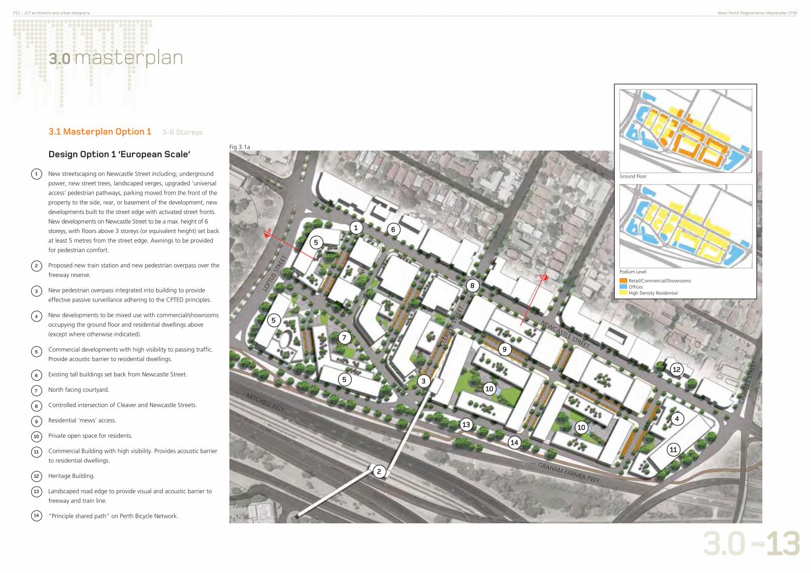
3.1 Masterplan Option 1 3-6 Storeys
A
B
New streetscaping on Newcastle Street including; underground
power, new street trees, landscaped verges, upgraded ‘universal
access’ pedestrian pathways, parking moved from the front of the
property to the side, rear, or basement of the development, new
developments built to the street edge with activated street fronts.
New developments on Newcastle Street to be a max. height of 6
storeys, with floors above 3 storeys (or equivalent height) set back
at least 5 metres from the street edge. Awnings to be provided
for pedestrian comfort.
Proposed new train station and new pedestrian overpass over the
freeway reserve.
New pedestrian overpass integrated into building to provide
effective passive surveillance adhering to the CPTED principles.
New developments to be mixed use with commercial/showrooms
occupying the ground floor and residential dwellings above
(except where otherwise indicated).
Commercial developments with high visibility to passing traffic.
Provide acoustic barrier to residential dwellings.
Existing tall buildings set back from Newcastle Street.
North facing courtyard.
Controlled intersection of Cleaver and Newcastle Streets.
Residential ‘mews’ access.
Private open space for residents.
Commercial Building with high visibility. Provides acoustic barrier
to residential dwellings.
Heritage Building.
Landscaped road edge to provide visual and acoustic barrier to
freeway and train line.
“Principle shared path” on Perth Bicycle Network.
Design Option 1 ‘European Scale’Fig 3.1a
NEWCASTLE STREETCLE
AVE
R ST
REET
CH
ARL
ES S
TREE
T
LOFT
US S
TREE
TRetail/Commercial/ShowroomsOfficesHigh Density Residential
Ground Floor
Podium Level
1
2
3
4
5
5
1
2
3
4
5
6
5
7
8
9
10
10
11
12
13
14
GRAHAM FARMER FWY
MITCHELL FWY
6
7
8
9
10
11
12
13
14
3.0 PAGE 14
P14 - JCY architects and urban designers West Perth Regeneration Masterplan 0748
3.0 masterplan
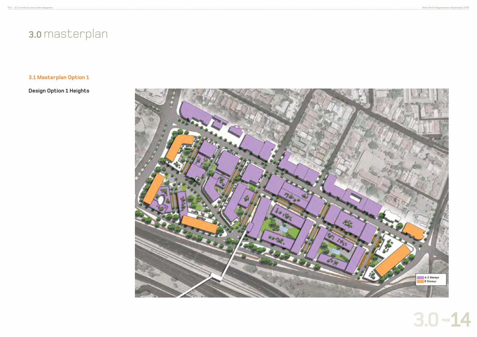
3.1 Masterplan Option 1
Design Option 1 Heights

3.0 PAGE 15
P15 - JCY architects and urban designers West Perth Regeneration Masterplan 0748
3.0 masterplan
3.1 Masterplan Option 1
Design Option 1 Yields
Section A
Section B
Retail/Commercial/ShowroomsOffi cesHigh Density Residential
AB
CD E
F
G
HI
J
K
European Scale 3- 6 storey
Ground Floor Podium Tower
Description Area (ha) Plot Ratio NLA Showroom Retail Office Res. Area No. Apart levels Office Res. Area No. Apart. levels Office Res. Area No. Apart Total Total Floors
A Office Building 0.362 2.5 9050 2500 0 3 7500 10000 4
B Showroom- Office 0.359 2.5 8975 2000 0 3 6500 8500 4
C Mixed Use 0.548 2.5 13700 700 800 0 4 11100 111 12600 5
D Mixed Use 0.470 2.5 11750 800 1100 1200 0 4 5800 7250 73 16150 5
E Showroom- Residential 0.538 2 10760 2000 400 0 4 7000 70 9400 5
F Showroom- Residential 0.470 2 9400 2300 0 4 6000 60 8300 5
G Showroom- Office 0.588 2.5 14700 1500 1400 0 5 12100 0 15000 6
H Office Building 0.416 2.5 10400 2000 0 5 8500 0 10500 6
I Office Building 0.567 2.5 14175 2500 0 5 13000 0 15500 6
J Mixed Use 1.168 2.5 29200 1200 1500 1040 10 4 5400 21000 210 29100 5
K Mixed Use 0.807 2.5 20175 2200 2100 21 4 6300 12000 120 20500 5
TOTAL 6.293 152285 7300 2700 16100 3140 31 65100 64350 644 0 0 0 155550
Showroom 7300
Retail 2700
Office 81200
Residential 67490 675
Net Plot Ratio 2.5
Fig 3.1b
Examples of ‘European Scale’ mixed use developments.
Freew
ay Newca
stle S
t
Freew
ay o
ff ra
mp
Charle
s St
Loftu
s St

3.0 PAGE 16
P16 - JCY architects and urban designers West Perth Regeneration Masterplan 0748
A
B
3.0 masterplan
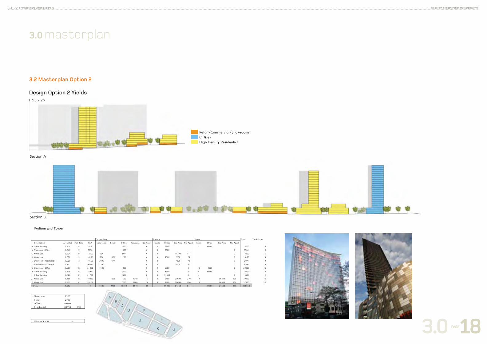
3.2 Masterplan Option 2
Design Option 2 “Tower + Podium”Fig 3.2a
Retail/Commercial/ShowroomsOfficesHigh Density Residential
Ground Floor
Podium Level
Tower
CH
ARL
ES S
TREE
T
New streetscaping on Newcastle Street including; underground
power, new street trees, landscaped verges, upgraded ‘universal
access’ pedestrian pathways, parking moved from the front of the
property to the side, rear, or basement of the development, new
developments built to the street edge with activated street fronts.
New developments on Newcastle Street to be a max. height of 6
storeys, with floors above 3 storeys (or equivalent height) set back
at least 5 metres from the street edge. Awnings to be provided
for pedestrian comfort.
Proposed new train station and new pedestrian overpass over the
freeway reserve.
New pedestrian overpass integrated into building to provide
effective passive surveillance adhering to the CPTED principles.
New developments to be mixed use with commercial/showrooms
occupying the ground floor and residential dwellings above
(except where otherwise indicated).
Commercial icon towers with high visibility to passing traffic.
Provide acoustic barrier to residential dwellings.
Existing tall buildings set back from Newcastle Street
North facing courtyard
Controlled intersection of Cleaver and Newcastle Streets
Residential Mews Access
North facing private open space for residents + public open
space
Commercial icon tower with high visibility. Provides acoustic
barrier to residential dwellings
Heritage Building
Landscaped road edge to provide visual and acoustic barrier to
freeway and train line.
‘Principle shared path’ on Perth Bicycle Network.
NEWCASTLE STREETCLE
AVE
R ST
REET
LOFT
US S
TREE
T
2
3
4
5
5
1
2
3
4
5
6
5
7
8
9
10
1011
12
13
14
GRAHAM FARMER FWY
MITCHELL FWY
6
7
8
9
10
11
12
13
14

3.0 PAGE 17
P17 - JCY architects and urban designers West Perth Regeneration Masterplan 0748
3.0 masterplan
Design Option 2 Heights
3.2 Masterplan Option 2
3.0 PAGE 18
P18 - JCY architects and urban designers West Perth Regeneration Masterplan 0748
Section A
Section B
Retail/Commercial/ShowroomsOffi cesHigh Density Residential
Podium and Tower
Ground Floor Podium Tower Total Total Floors
Description Area (ha) Plot Ratio NLA Showroom Retail Office Res. Area No. Apart levels Office Res. Area No. Apart. levels Office Res. Area No. Apart
A Office Building 0.404 3.5 14140 2500 0 3 7500 3 6000 0 16000 7
B Showroom- Office 0.346 2.5 8650 2000 0 3 6500 0 8500 4
C Mixed Use 0.504 2.5 12600 700 800 0 4 11100 111 0 12600 5
D Mixed Use 0.650 2.5 16250 800 1100 1200 0 3 5800 7250 73 0 16150 4
E Showroom- Residential 0.528 2 10550 2000 400 0 3 7000 70 0 9400 4
F Showroom- Residential 0.465 2 9300 2300 0 3 6000 60 0 8300 4
G Showroom- Office 0.600 3.5 21000 1500 1400 0 2 6000 0 10 12000 0 20900 13
H Office Building 0.426 3.5 14910 2000 0 3 8500 0 4 6000 0 16500 8
I Office Building 0.620 3.5 21700 2500 0 3 13000 0 4 0 15500 8
J Mixed Use 1.166 3.5 40810 1200 1500 1040 10 3 5400 21000 210 14 10800 108 39900 18
K Mixed Use 0.803 3.5 28105 2200 2100 21 3 6300 12000 120 14 10800 108 31300 18
TOTAL 6.512 0 7300 2700 16100 3140 31 59000 64350 644 24000 21600 216 195050
Showroom 7300
Retail 2700
Office 99100
Residential 89090 891
Net Plot Ratio 3
AB
CD E
F
G
HI
J
K
3.2 Masterplan Option 2
Design Option 2 YieldsFig 3.7.2b
3.0 masterplan

3.0 PAGE 19
P19 - JCY architects and urban designers West Perth Regeneration Masterplan 0748
WIth the creation of the proposed pedestrian freeway reserve
overpass, people would be able to walk or ride their bicycles
from Beatty Park in Leederville to Kings Park, linking all sites in
between including;
• The West Perth Regeneration Masterplan study area
• The proposed new train station
• City West retail/commercial area
• Harold Boas Gardens
• West Perth commercial district (inc. hospitality venues)
• Kings Park
Currently the pedestrian route from Beatty Park to Kings Park
involves crossing the freeway at the Loftus Street freeway
overpass which currently does not provide adequate levels of
pedestrian or cyclist safety or comfort.
3.0 masterplan
3.3 Activated Pedestrian Spine
Fig 3.3 Pedestrian connection to Kings Park

3.0 PAGE 20
P20 - JCY architects and urban designers West Perth Regeneration Masterplan 0748
3.0 masterplan
3.4.1 Current Movement
Fig 3.4.1 Current Transport and Movement
• The area is well serviced by major transport links.
• Public transport includes the Leederville Train Station,
which is within 800m of a part of the study area, as well as
Transperth bus routes along Newcastle Street.
• Pedestrian movement is limited by the freeway and other
major roads.
• The study area is connected to dedicated cycle paths to and from the city.
S t u d y A r e a
M a j o r R o a d s
M i n o r R o a d s
C y c l e p a t h s
L i g h t p e d e s t r i a nt r a f f i c
B u s R o u t e
J o o n d a l u p T r a i nL i n e
F r e m a n t l e T r a i nL i n e
E x i s t i n g T r a i nS t a t i o n
4 0 0 / 8 0 0 m R a d i u s
8 0 0 m R A D I U S
4 0 0 m R A D I U S

3.0 PAGE 21
P21 - JCY architects and urban designers West Perth Regeneration Masterplan 0748
3.0 masterplan
3.4.2 Proposed Movement
Fig 3.4.2 Proposed Transport and Movement
• A new pedestrian/cycle connection is proposed across the
freeway and rail reserve, with a new train station on the
Clarkson line.
• The train station will be an ‘inner city’ stop and function in a
similar way to a tram stop, similar to the City West, McIver,
Claisebrook, East Perth and Esplanade train stops. These are
characterised by the relatively short distance between them
and the Perth Central train station.
• Refer to APPENDIX A for Traffic Study.
B E A T T Y P A R K
C I T Y W E S T
8 0 0 m R A D I U S
4 0 0 m R A D I U S
S t u d y A r e a
H e a v y p e d e s t r i a nf l o w
C y c l e p a t h
M a j o r D e s t i n a t i o n
M a j o r R o a d s
M i n o r R o a d s
M u s e
B r i d g e - N e w t r a i nS t a t i o n
E x i s t i n g T r a i nS t a t i o n
F r e m a n t l e T r a i nL i n e
J o o n d a l u p T r a i nL i n e
B u s R o u t e
4 0 0 / 8 0 0 m R a d i u s
LE
ED
ER
VI
LL
E
PR
EC
IN
CT
FI
TZ
GE
RA
LD
DI
ST
RI
CT
T O K I N G S P A R K
3.0 PAGE 22
P22 - JCY architects and urban designers West Perth Regeneration Masterplan 0748
3.4.3 Movement and Car Parking
A report on traffic movement and potential traffic
generation has been prepared by SKM and is included in
the Appendices.
See Fig 3.4.1 & 3.4.2 for diagrams showing current and
proposed transport and movement.
PEDESTRIAN & CYCLING ACCESS AND MOVEMENTThe study area has access to the Principal Shared Path which runs
along the Mitchell Freeway on the Perth Bicycle Network. The path
connects with Leederville Station and runs through to the city.
North-South pedestrian movement is restricted by the Mitchell
freeway as well as the car-dominated Loftus Street bridge. Other
north-south crossings include the Leederville Train Station overpass
to the north and Fitzgerald Street to the south. The masterplan
proposes a new pedestrian overpass across the freeway.
PUBLIC TRANSPORT ACCESS AND MOVEMENTThe majority of the study area is within 1km of the Leederville
Train Station which is located to the North-west of the study
area.
A single Transperth bus service, the number 15 bus, operates
along Newcastle Street. Other bus routes operate within walking
distance of the study site.
The masterplan proposes a new ‘inner-city’ train station.
MOTOR VEHICLE ACCESS AND MOVEMENT The study area has access to a number of major vehicular
transportation routes including the Mitchell Freeway, Charles,
Loftus and Newcastle Streets. Congestion is an issue and is
discussed in the traffic report (Refer Appendix 5.1)
UNIVERSAL DESIGNUniversal design is to be an integral component of the planning
and design process. Compliance with the “Disability Standards
for Access to Premises (Premises Standard)” will be mandatory
for all new developments.
PRIVATE & PUBLIC ACCESSWAYS AND LANEWAYSIn order to ensure adequate provision of safe, secure, visually
acceptable and accessible parking for residents and workers, it
is important to minimise the visual impact of access gates and
garages by incorporating these elements as integral elements
of the buildings and streetscape. Vehicle movement must not
compromise pedestrian movement and safety.
SAFETY AND SECURITYThe principles of CPTED (Crime Prevention Through Environmental
Design) are to be incorporated into the development.
Movement elements such as the proposed pedestrian freeway
overpass have been incorporated into buildings in order to
maximise passive surveillance with commuters exiting onto
activated streets. The introduction of residential dwellings into
the area ensures that the streets are activated beyond ‘9 -5’ as is
currently the case.
FACILITIESDevelopments will be required to provide safe and secure bicycle
storage and end-of trip facilities (such as change areas and
showers) to encourage alternative methods of transport to the
private motor vehicle.
TRANSIT ORIENTATED DEVELOPMENT (TOD)Transit Oriented Developments are relatively dense, walkable
urban developments centred around public transport
infrastructure. TOD reduces the reliance on vehicles and
prioritises alternative transport methods. Currently the study area
cannot be classed as a TOD given the absence of a high density
residential component and approximately half of the site is more
than 800m from the Leederville Train Station.
The masterplan proposal adheres to the principles of TOD and
includes;
• A proposed new inner-city train station that is within 400m of the entire site area.
• High density residential dwellings, commercial and office developments in the site area
• A new pedestrian connection north-south across the freeway.
• Connection to the Perth Bicycle Network
• A safe and pedestrian-friendly environment within the study area.
CAR PARKING
The study area is currently a ‘General Parking Zone’, where
both long and short term public parking may be permitted,
with ‘Category 4’ streets, which are streets with relatively low
concentrations of pedestrians, in the Perth Parking Policy.
The Perth Parking policy prescribes maximum parking requirements
as opposed to minimum requirements. The location of the study
area next to a (proposed) train station is to reduce the reliance on
private motor vehicles and thus parking requirements.
3.0 masterplan
In order to create a safe urban environment, day and night
developments should minimise the opportunity for crime
and maximise the sense of safety through the design and
management of built and landscaped environments.
Currently the West Perth Regeneration Area is an under
populated and poorly lit area and is potentially an unsafe
pedestrian environment, especially after hours.
This will fundamentally change when the area is redeveloped, as
passive surveillance from ground and first floor tenancies is the
greatest deterrent for crime.
New street lighting will be to relevant Australian Standards
and will ensure adequate lighting for pedestrians, cyclists and
motorists.
3.5 Safety and Security

4.0 PAGE 23
P23 - JCY architects and urban designers West Perth Regeneration Masterplan 0748
4.0 implementation
4.1 Feasibility Assessment 4.2 Incentives to Develop
The impetus for private sector action in the study area will be
driven by market forces. The re-zoning of the land and increased
plot ratios will increase the value of the land and the potential
redevelopment scale and options.
The consultation process will involve identifying the major
stakeholders and approaching them directly. This approach is
most affective given the relatively small number of parties with
large holdings of land. The consultation will illustrate to the key
stakeholders the opportunities in redevelopment
4.3 Developer Contribution to Public Realm
The Town of Vincent can redevelop the public realm through
Developer Contributions (a ‘sinking fund’). Calculation of the
contribution amount may be based on the increase in value of
the land as a result of the new density zoning.
‘Cash in Lieu’ contributions for parking provision may be possible.
The study area is however controlled by the ‘Perth Parking Policy’
and there are no minimum parking requirements, making cash
in lieu payments a less likely means of generating funds. Cash
in Lieu is most likely to occur with a reduction in the number of
residential car bays required, which is covered by the Residential
Design Codes of Western Australia. Residential car bays may be
reduced due to the proximity of the study area to a train station.
4.4 Traffic Analysis
The traffic analysis undertaken by SKM (refer to APPENDIX A)
provides preliminary advice on traffic generation and advice on
potential issues relating to road congestion arising from the
redevelopment. Based on the analysis, SKM recommends that
a full strategic assessment be undertaken to ascertain the full
impact of the increased traffic arising from the redevelopment.
The Town of Vincent Town Planning Scheme No. 1 and Policies
The Town of Vincent Town Planning Scheme No. 1 and Policies do
not adequately address all of redevelopment issues and a new set
of guidelines specific to the study area will need to be developed.
4.5 Planning Considerations
TOWN PLANNING SCHEME The Town of Vincent is restricted in its determination of
development applications in this area by the existing provisions
of the City of Perth City Planning Scheme No.2. Until the Town
addresses the area through an appropriate Scheme Amendment
and/or within new Town Planning Scheme No.2, development
within the study area is limited to the current provisions of
the City of Perth City Planning Scheme No.2. The current
City of Perth City Planning Scheme No.2 provisions would not
accommodate either of the draft options by virtue of plot ratio,
land uses and the like. Therefore, appropriate amendments
to the Town of Vincent’s Town Planning Scheme No.1 and/
or new Town Planning Scheme No.2 will need to be initiated
to accommodate the proposed Mas terplan with respect to
appropriate zonings and the like. Built Form Design Guidelines
would also be required to be produced pursuant to the Scheme
Amendment or the new Town Planning Scheme No.2 to guide
the Town and landowners with respect to new development in
the area.
CAR PARKINGIn addition to the car parking requirements of the City planning
Scheme No.2, the study area is subject to the provisions of
the Perth Parking Policy, created pursuant to the Perth Parking
Management Act 1998. The policy provides guidance to the
State Government in exercising the powers conferred upon it
by the Act, and to the City of Perth (in this case, the Town of
Vincent) in providing a framework for assessing applications for
parking facilities under the City of Perth City Planning Scheme.
The Policy essentially makes provisions with respect to zones
governing the provision of public parking; and ‘desirable’ and
‘maximum’ number of bays per hectare for tenant parking
dependant on the category of the street from which access is
taken.
No. Expenditure ($)
Dwellings * 776 8.0m
Workers 920 0.8m
No. Expenditure ($)
Dwellings * 776 8.0m
Workers 920 0.8m
* Includes 224 existing dwellings
Multiple Feasible
Supermarket/ Superdeli(400m²)
1.48
Café 2.01
Restaurant 1.91
Newsagency 0.48
Fashion 0.58
Multiple Feasible
Supermarket/ Superdeli(400m²)
1.48
Café 2.01
Restaurant 1.91
Newsagency 0.48
Fashion 0.58
No. Expenditure ($)
Dwellings * 1,328 14.0m
Workers 1,840 1.5m
No. Expenditure ($)
Dwellings * 1,328 14.0m
Workers 1,840 1.5m
* Includes 224 existing dwellings
Multiple Feasible
Supermarket/ Superdeli(400m²)
2.95
Café 4.02
Restaurant 3.82
Newsagency 0.95
Fashion 1.16
Multiple Feasible
Supermarket/ Superdeli(400m²)
2.95
Café 4.02
Restaurant 3.82
Newsagency 0.95
Fashion 1.16
No. Expenditure ($)
Dwellings * 1,880 19.0m
Workers 1,656 1.0m
No. Expenditure ($)
Dwellings * 1,880 19.0m
Workers 1,656 1.0m
Multiple Feasible
Supermarket/ Superdeli(400m²)
4.43
Café 6.02
Restaurant 5.73
Newsagency 1.43
Fashion 1.74
Multiple Feasible
Supermarket/ Superdeli(400m²)
4.43
Café 6.02
Restaurant 5.73
Newsagency 1.43
Fashion 1.74
* Includes 224 existing dwellings
SCENARIO ONE
Plot Ratio = 1
SCENARIO TWO
Plot Ratio = 2
SCENARIO THREE
Plot Ratio = 3