Embed Size (px)
Citation preview
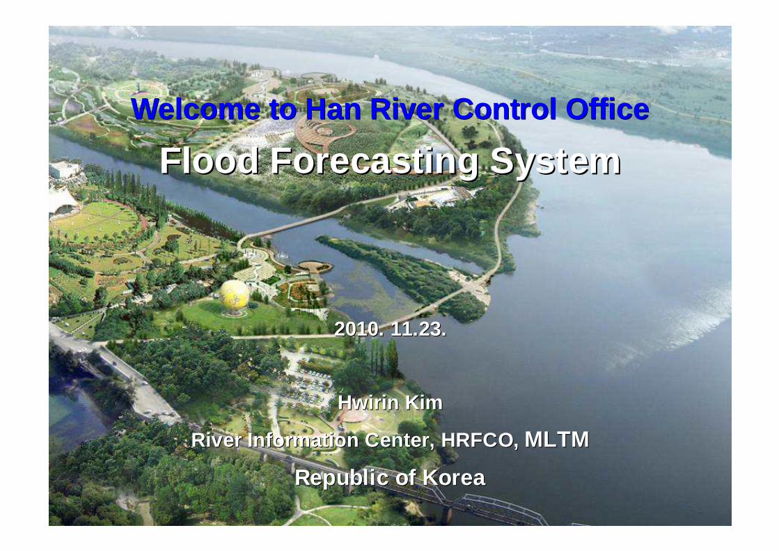
Welcome to Han River Control OfficeWelcome to Han River Control Office
Flood Forecasting SystemFlood Forecasting System
2010. 11.23.2010. 11.23.
Hwirin Kim Hwirin Kim
River Information Center, HRFCO, River Information Center, HRFCO, MLTMMLTM
Republic of KoreaRepublic of Korea
22
ContentsContents
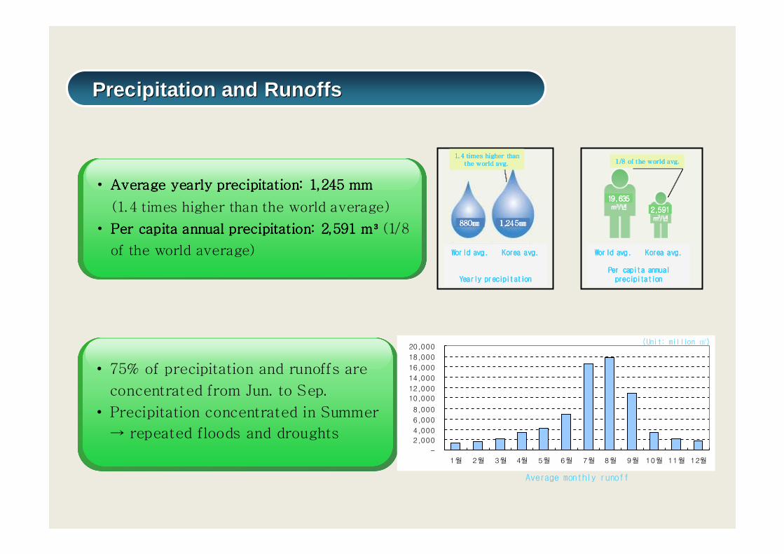
• Average yearly precipitation: 1,245 mmAverage yearly precipitation: 1,245 mmAverage yearly precipitation: 1,245 mmAverage yearly precipitation: 1,245 mm
(1.4 times higher than the world average)
• Per capita annual precipitation: 2,591 mPer capita annual precipitation: 2,591 mPer capita annual precipitation: 2,591 mPer capita annual precipitation: 2,591 m³³³³ (1/8
of the world average)
• 75% of precipitation and runoffs are
concentrated from Jun. to Sep.
• Precipitation concentrated in Summer
→ repeated floods and droughts
1/8 of the world avg.1/8 of the world avg.1/8 of the world avg.1/8 of the world avg.1. 4 times higher than 1. 4 times higher than 1. 4 times higher than 1. 4 times higher than
the world avg.the world avg.the world avg.the world avg.
880880880880㎜㎜㎜㎜ 1,241,241,241,245555㎜㎜㎜㎜
19,63519,63519,63519,635
2,5912,5912,5912,591
-
2,000
4,000
6,000
8,000
10,000
12,000
14,000
16,000
18,000
20,000
1월 2월 3월 4월 5월 6월 7월 8월 9월 10월 11월 12월
Average monthly runoff
(Unit: million ㎥)
World avg. Korea avg.World avg. Korea avg.World avg. Korea avg.World avg. Korea avg.
Yearly precipitationYearly precipitationYearly precipitationYearly precipitation
World avg. Korea avg.World avg. Korea avg.World avg. Korea avg.World avg. Korea avg.
Per capita annual Per capita annual Per capita annual Per capita annual precipitationprecipitationprecipitationprecipitation
Precipitation and RunoffsPrecipitation and Runoffs
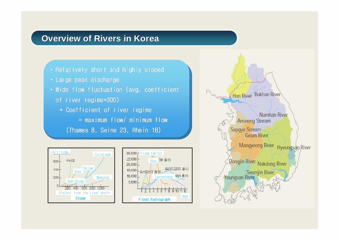
•• Relatively short and highly slopedRelatively short and highly slopedRelatively short and highly slopedRelatively short and highly slopedRelatively short and highly slopedRelatively short and highly slopedRelatively short and highly slopedRelatively short and highly sloped
•• Large peak dischargeLarge peak dischargeLarge peak dischargeLarge peak dischargeLarge peak dischargeLarge peak dischargeLarge peak dischargeLarge peak discharge
•• Wide flow fluctuation (avg. coefficient Wide flow fluctuation (avg. coefficient Wide flow fluctuation (avg. coefficient Wide flow fluctuation (avg. coefficient Wide flow fluctuation (avg. coefficient Wide flow fluctuation (avg. coefficient Wide flow fluctuation (avg. coefficient Wide flow fluctuation (avg. coefficient
of river regime=300)of river regime=300)of river regime=300)of river regime=300)of river regime=300)of river regime=300)of river regime=300)of river regime=300)
* Coefficient of river regime* Coefficient of river regime* Coefficient of river regime* Coefficient of river regime* Coefficient of river regime* Coefficient of river regime* Coefficient of river regime* Coefficient of river regime
= maximum flow/ minimum flow= maximum flow/ minimum flow= maximum flow/ minimum flow= maximum flow/ minimum flow= maximum flow/ minimum flow= maximum flow/ minimum flow= maximum flow/ minimum flow= maximum flow/ minimum flow
(Thames 8, Seine 23, Rhein 18)(Thames 8, Seine 23, Rhein 18)(Thames 8, Seine 23, Rhein 18)(Thames 8, Seine 23, Rhein 18)(Thames 8, Seine 23, Rhein 18)(Thames 8, Seine 23, Rhein 18)(Thames 8, Seine 23, Rhein 18)(Thames 8, Seine 23, Rhein 18)
Altitude
HanSeine
Colorado
Nak-Dong
Flow (m3/s)
Han
Tennessee
Distant from the river mouth (km)SlopeSlopeSlopeSlope Flood hydrographFlood hydrographFlood hydrographFlood hydrograph
day
Mekong
Overview of Rivers in KoreaOverview of Rivers in Korea
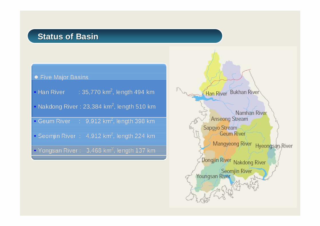
�� Five Major Basins Five Major Basins
•• Han River : 35,770 kmHan River : 35,770 km22, length, length 494 km494 km
•• Nakdong River : 23,384 kmNakdong River : 23,384 km22, length, length 510 km510 km
•• Geum RiverGeum River : 9,912 km: 9,912 km22, length, length 398 km398 km
•• Seomjin River Seomjin River : 4,912 km: 4,912 km22, length, length 224 km224 km
•• Yongsan RiverYongsan River : 3,468 km: 3,468 km22, length, length 137 km137 km
Status of BasinStatus of Basin
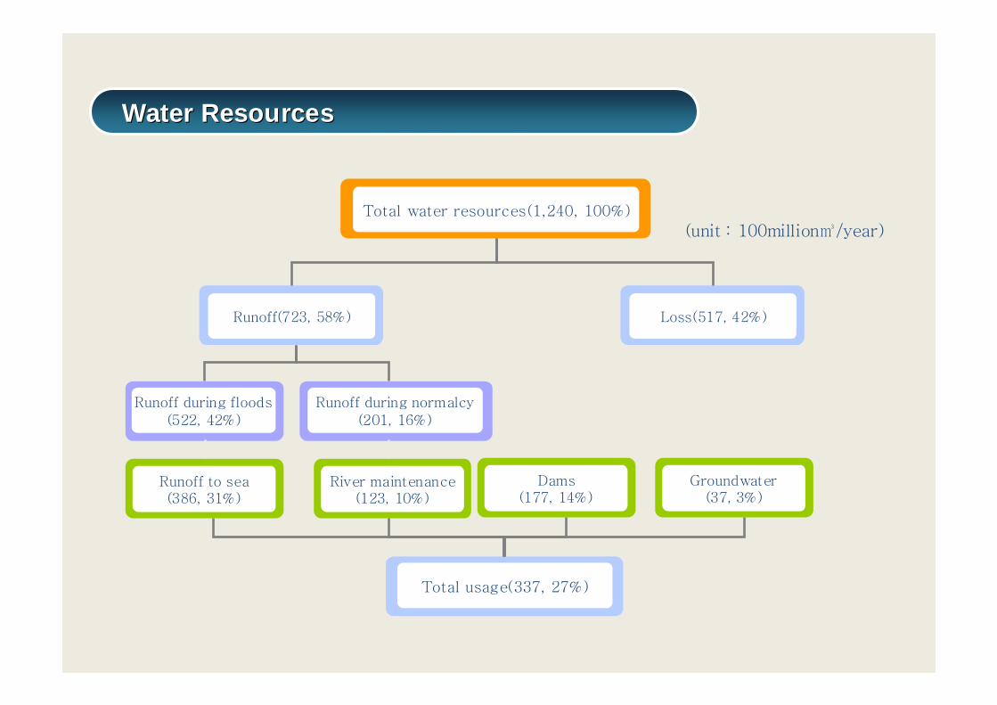
(unit : 100million㎥/year)
Runoff during floods(522, 42%)
Runoff(723, 58%)
Total water resources(1,240, 100%)
Total usage(337, 27%)
Runoff to sea(386, 31%)
Loss(517, 42%)
Runoff during normalcy(201, 16%)
River maintenance(123, 10%)
Dams(177, 14%)
Groundwater(37, 3%)
Water ResourcesWater Resources

Increase in frequency of heavy rain over 100mm per 1 day (1.7 times to 1970’s)
Annual average frequency of disaster : Increase from 5.3 (1940~1970) to
8.8(1980~1999)
Since 2000, increase sharply in damages caused by typhoons such as RUSA
(in 2002) and MAEMI(in 2003)
1970 1975 1980 1985 1990 1995 2000 2005 20100
10
20
30
40
50
60
70
연 도연 도연 도연 도
100m
m 이
상 강
우발
생 일
수100m
m 이
상 강
우발
생 일
수100m
m 이
상 강
우발
생 일
수100m
m 이
상 강
우발
생 일
수
강수일수 경향성
1970 1975 1980 1985 1990 1995 2000 2005 20100
10
20
30
40
50
60
70
연 도연 도연 도연 도
100m
m 이
상 강
우발
생 일
수100m
m 이
상 강
우발
생 일
수100m
m 이
상 강
우발
생 일
수100m
m 이
상 강
우발
생 일
수
강수일수 경향성
Increase in Localized heavy rain & floodIncrease in Localized heavy rain & flood
YearYearYearYear
Rainy days over 100mm
Rainy days over 100mm
Rainy days over 100mm
Rainy days over 100mm
Rainy daysRainy daysRainy daysRainy daysTrendTrendTrendTrend
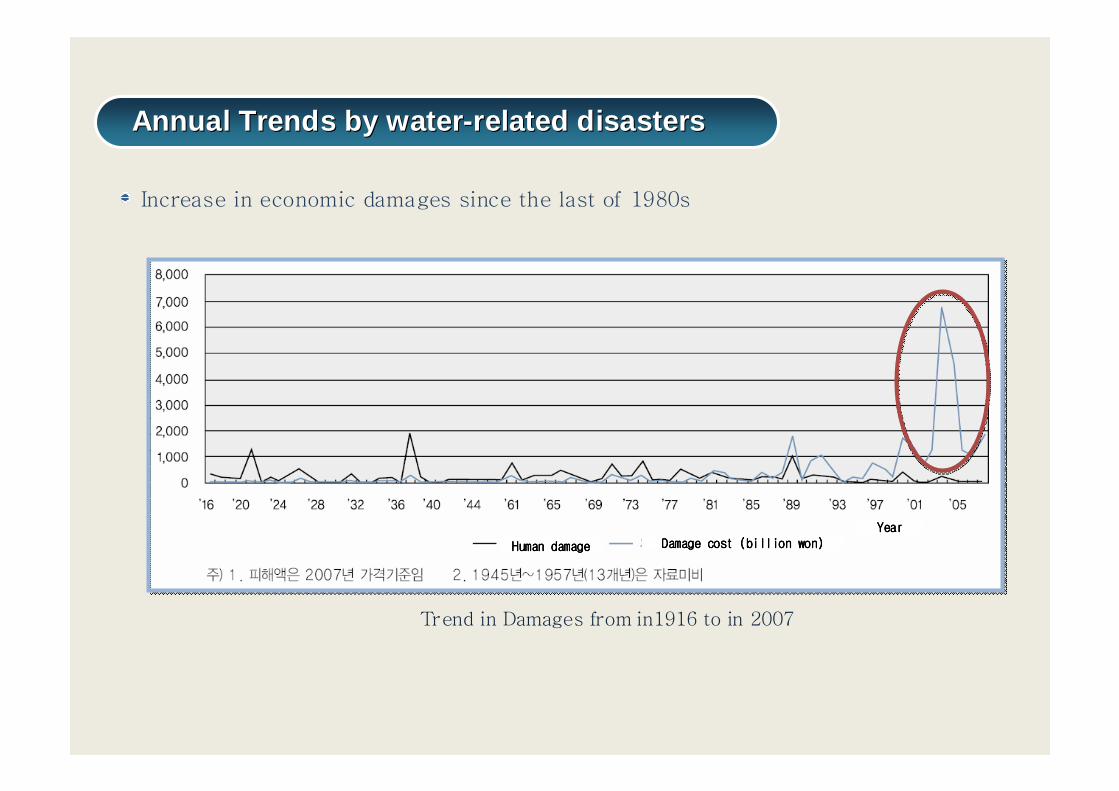
Trend in Damages from in1916 to in 2007
Increase in economic damages since the last of 1980s
Annual Trends by water-related disastersAnnual Trends by water-related disasters
Human damageHuman damageHuman damageHuman damage
YearYearYearYearDamage cost (billion won)Damage cost (billion won)Damage cost (billion won)Damage cost (billion won)
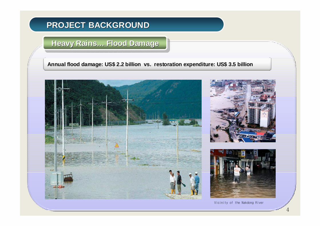
PROJECT BACKGROUNDPROJECT BACKGROUND
Heavy Rains… Flood DamageHeavy RainsHeavy Rains …… Flood DamageFlood Damage
Annual flood damage: US$ 2.2 billion vs. restorat ion expenditure: US$ 3.5 billion
Vicinity of the Nakdong River
4
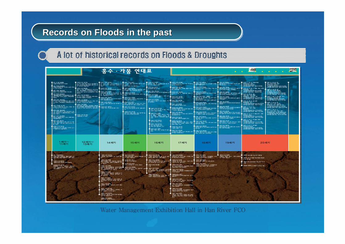
Water Management Exhibition Hall in Han River FCO
Records on Floods in the pastRecords on Floods in the past
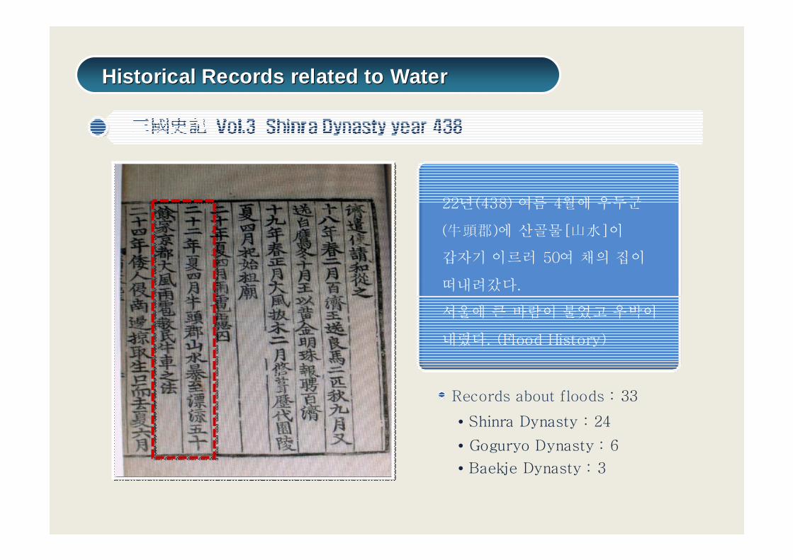
22년(438) 여름 4월에 우두군
(牛頭郡)에 산골물[山水]이
갑자기 이르러 50여 채의 집이
떠내려갔다.
서울에 큰 바람이 불었고 우박이
내렸다. (Flood History)
Records about floods : 33
• Shinra Dynasty : 24
• Goguryo Dynasty : 6
• Baekje Dynasty : 3
Historical Records related to WaterHistorical Records related to Water
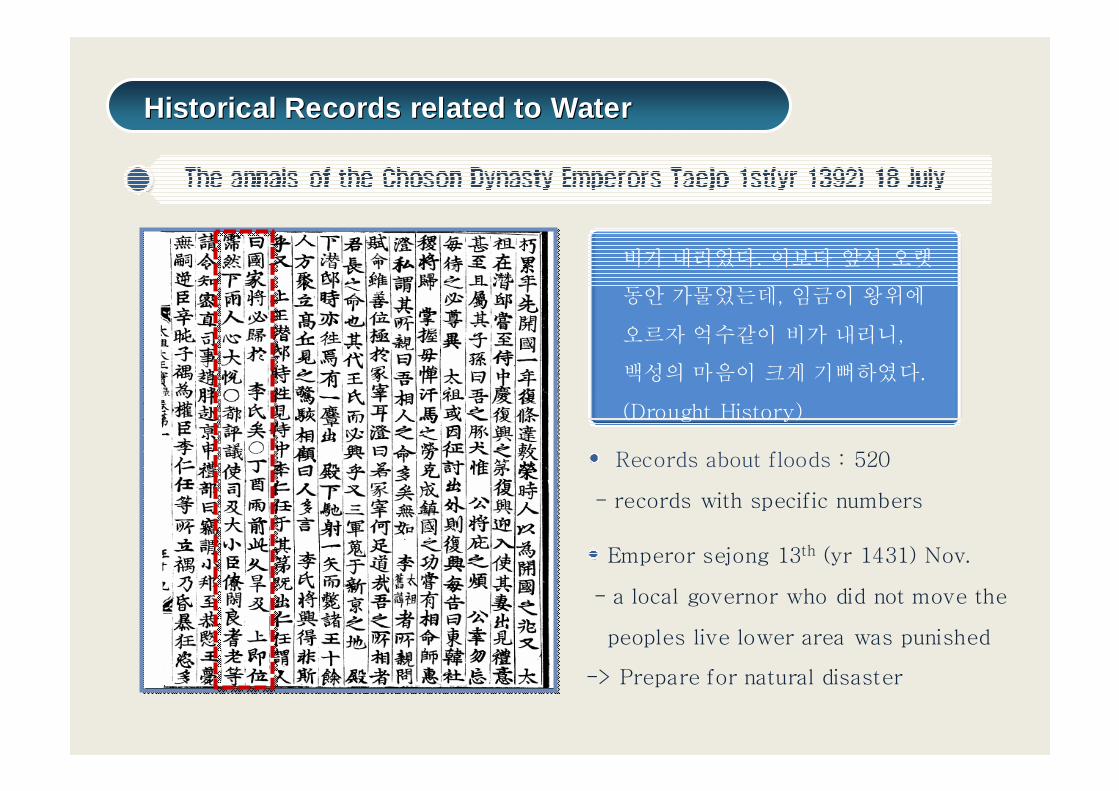
Records about floods : 520
- records with specific numbers
비가 내리었다. 이보다 앞서 오랫
동안 가물었는데, 임금이 왕위에
오르자 억수같이 비가 내리니,
백성의 마음이 크게 기뻐하였다.
(Drought History)
Emperor sejong 13th (yr 1431) Nov.
- a local governor who did not move the
peoples live lower area was punished
-> Prepare for natural disaster
Historical Records related to WaterHistorical Records related to Water

Flooding of Yeongduk county of kyeongbuk province by typhoon Sarah(1959 )
-1950: Flooding by Typhoon -1958: Flooding by Typhoon -1959: Flooding by Typhoon
Historical Flood Damage – 1950sHistorical Flood Damage – 1950s
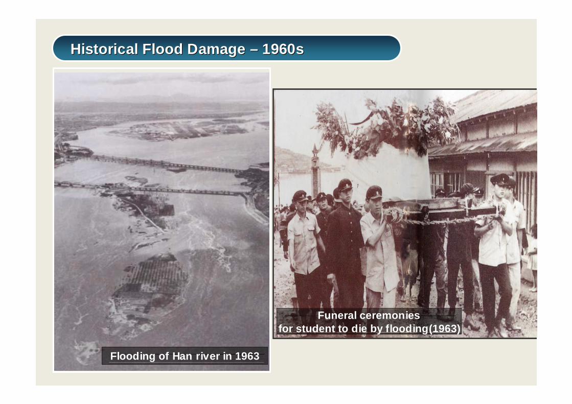
Flooding of Han river in 1963
-1963: Typhoon Shirley and Ves
-1964: Heavy rain in the central region
-1965: Severe drought until June,
-1969: Big flood in Geum river system1961 : River law1967 : Natural disaster
countermeasures law
Funeral ceremoniesfor student to die by flooding(1963)
Historical Flood Damage – 1960sHistorical Flood Damage – 1960s

Inundation by heavy rainfall in 1970(Gangwon)
Bridge demolition by typhoon Judy (Jeju island)
-1970: Typhoon Olga, Billie-1972: Heavy rain (big flood science 1925) -1975,1976,1977,1979: Heavy rain, Typhoon ,
Storm surge
Historical Flood Damage – 1970sHistorical Flood Damage – 1970s
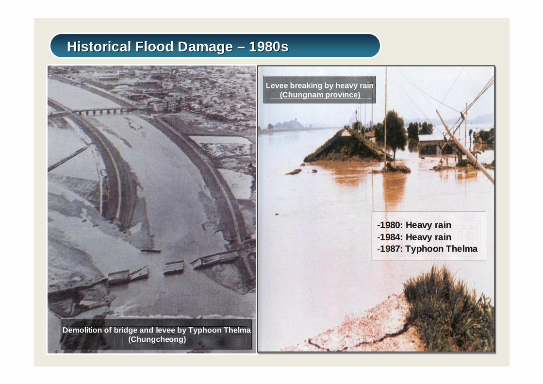
Demolition of bridge and levee by Typhoon Thelma(Chungcheong)
Levee breaking by heavy rain(Chungnam province)
-1980: Heavy rain-1984: Heavy rain-1987: Typhoon Thelma
Historical Flood Damage – 1980sHistorical Flood Damage – 1980s
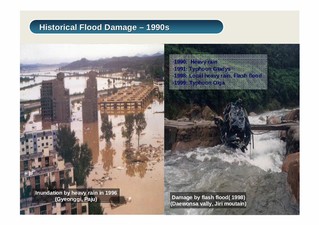
Inundation by heavy rain in 1996(Gyeonggi, Paju) Damage by flash flood( 1998)
(Daewonsa vally, Jiri moutain)
-1990: Heavy rain-1991: Typhoon Gladys-1998: Local heavy rain, Flash flood -1999: Typhoon Olga
Historical Flood Damage – 1990sHistorical Flood Damage – 1990s
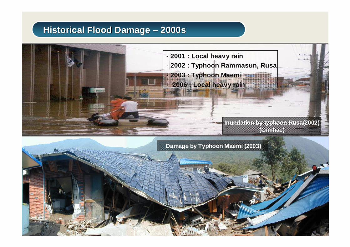
Inundation by typhoon Rusa(2002)(Gimhae)
- 2001 : Local heavy rain- 2002 : Typhoon Rammasun, Rusa- 2003 : Typhoon Maemi- 2006 : Local heavy rain
Damage by Typhoon Maemi (2003)
Historical Flood Damage – 2000sHistorical Flood Damage – 2000s
Han River Flood Control OfficeHan River Flood Control Office
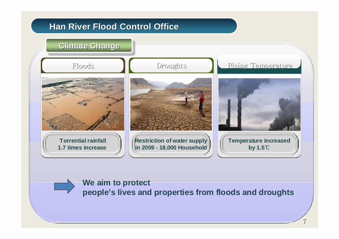
Climate ChangeClimate ChangeClimate Change
지역단위 Road Show 개최
FloodsFloods
Torrential rainfall 1.7 times increase
DroughtsDroughts Rising TemperatureRising Temperature
Restriction of water supply in 2009 - 18,000 Household
Temperature increased by 1.5℃℃℃℃
7
We aim to protect people’s lives and properties from floods and droug hts
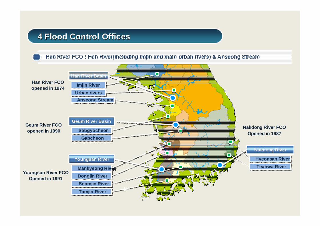
Han River Basin
Imjin RiverImjin River
Urban riversUrban rivers
Anseong StreamAnseong Stream
Geum River BasinGeum River Basin
SabgyocheonSabgyocheon
GabcheonGabcheon
Youngsan RiverYoungsan River
Mankyeong RiverMankyeong River
Dongjin RiverDongjin River
Seomjin RiverSeomjin River
Tamjin RiverTamjin River
Nakdong RiverNakdong River
Hyeonsan RiverHyeonsan River
Teahwa RiverTeahwa River
Han River FCOopened in 1974
Geum River FCOopened in 1990
Youngsan River FCOOpened in 1991
Nakdong River FCOOpened in 1987
4 Flood Control Offices4 Flood Control Offices
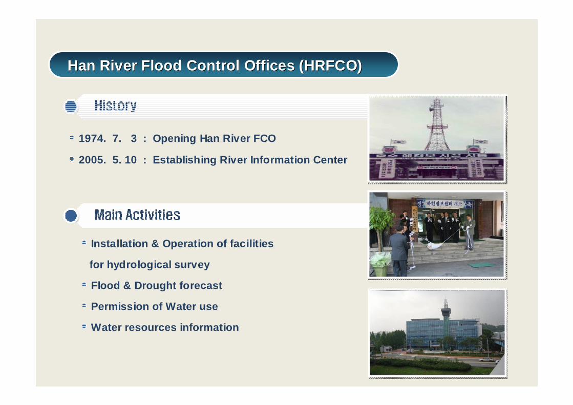
1974. 7. 3 : Opening Han River FCO
2005. 5. 10 : Establishing River Information Cen ter
Installation & Operation of facilities
for hydrological survey
Flood & Drought forecast
Permission of Water use
Water resources information
Han River Flood Control Offices (HRFCO)Han River Flood Control Offices (HRFCO)
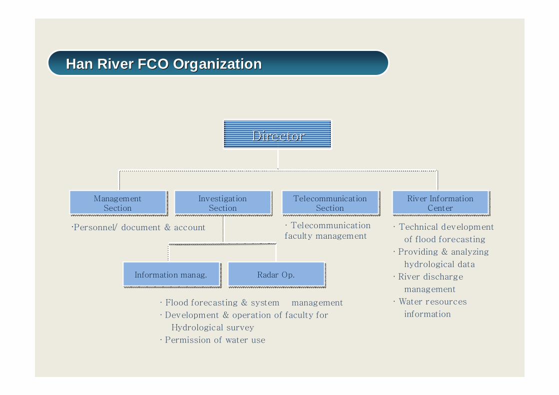
·Personnel/ document & account · Technical development
of flood forecasting
· Providing & analyzing
hydrological data
· River discharge
management
· Water resources
information
· Telecommunication faculty management
DirectorDirector
ManagementSection
ManagementSection
InvestigationSection
InvestigationSection
River InformationCenter
River InformationCenter
TelecommunicationSection
TelecommunicationSection
· Flood forecasting & system management
· Development & operation of faculty for
Hydrological survey
· Permission of water use
Information manag.Information manag. Radar Op.Radar Op.
Han River FCO OrganizationHan River FCO Organization
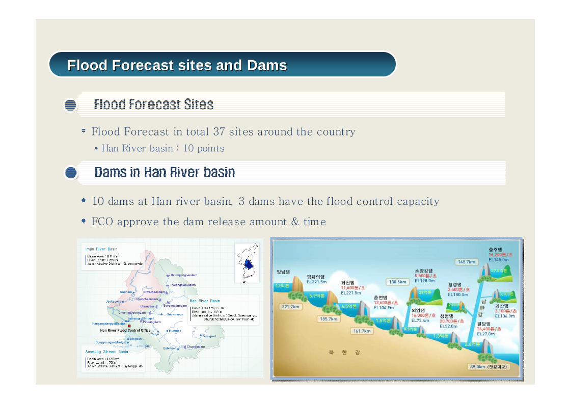
Flood Forecast in total 37 sites around the country
• Han River basin : 10 points
10 dams at Han river basin, 3 dams have the flood control capacity
FCO approve the dam release amount & time
Flood Forecast sites and DamsFlood Forecast sites and Dams
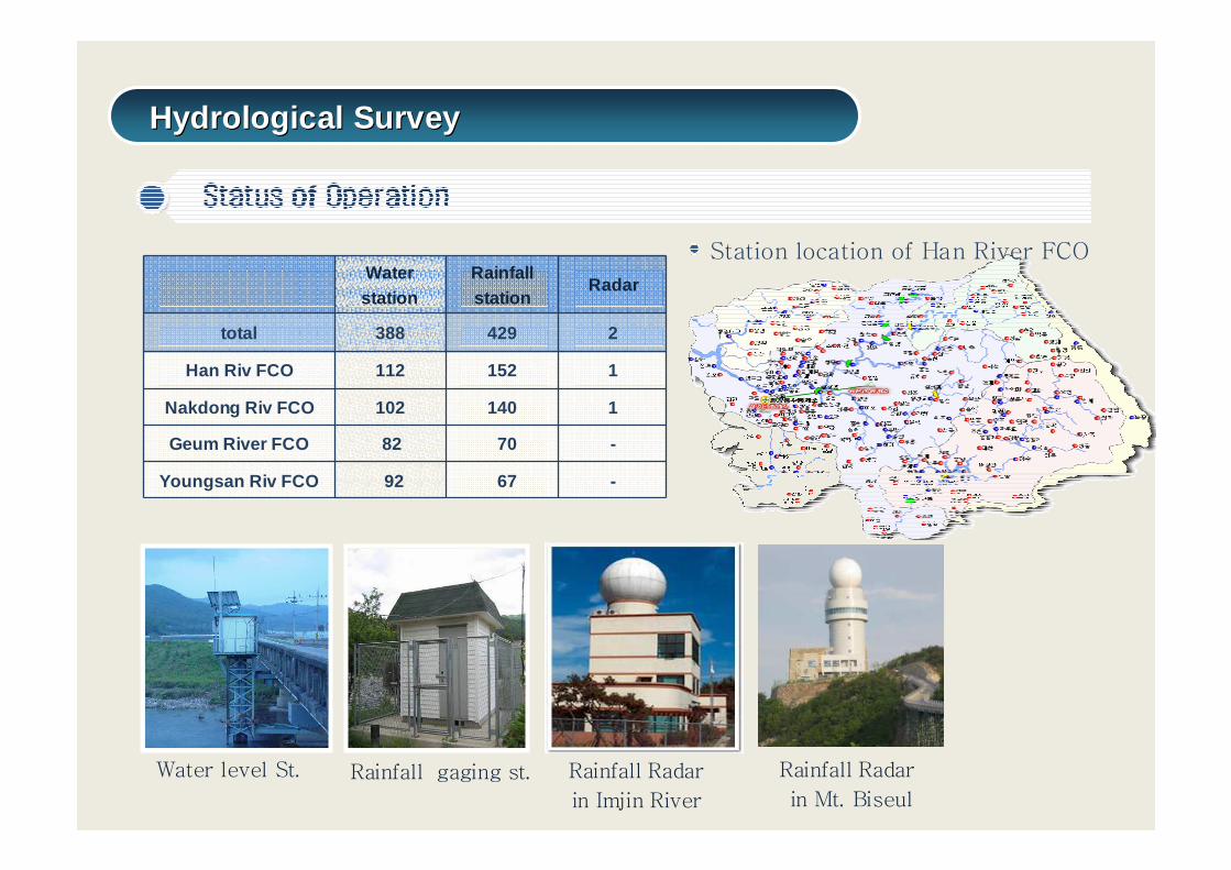
Waterstation
Rainfallstation
Radar
total 388 429 2
Han Riv FCO 112 152 1
Nakdong Riv FCO 102 140 1
Geum River FCO 82 70 -
Youngsan Riv FCO 92 67 -
Rainfall Radar
in Imjin River
Water level St. Rainfall gaging st.
Station location of Han River FCO
Rainfall Radar
in Mt. Biseul
Hydrological SurveyHydrological Survey
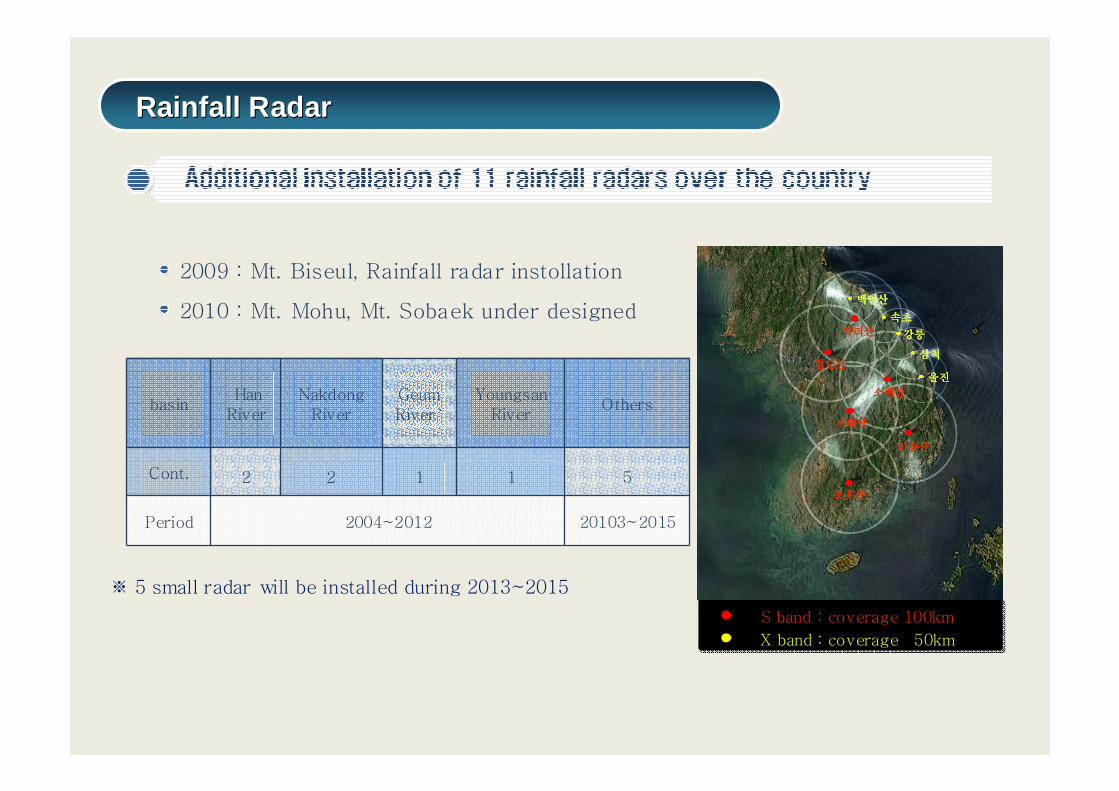
※ 5 small radar will be installed during 2013~2015
검단산검단산검단산검단산
서대산서대산서대산서대산
모후산모후산모후산모후산
비슬산비슬산비슬산비슬산
소백산소백산소백산소백산
가리산가리산가리산가리산
백암산백암산백암산백암산
속초속초속초속초
강릉강릉강릉강릉
삼척삼척삼척삼척
울진울진울진울진
S band : coverage 100km
X band : coverage 50km
basinHan
RiverNakdong
RiverGeum River`
Youngsan River
Others
Cont. 2 2 1 1 5
Period 2004~2012 20103~2015
2009 : Mt. Biseul, Rainfall radar instollation
2010 : Mt. Mohu, Mt. Sobaek under designed
Rainfall RadarRainfall Radar
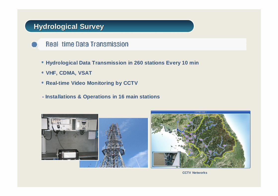
Hydrological Data Transmission in 260 stations Ever y 10 min
VHF, CDMA, VSAT
Real-time Video Monitoring by CCTV
- Installations & Operations in 16 main stations
CCTV Networks
Hydrological SurveyHydrological Survey
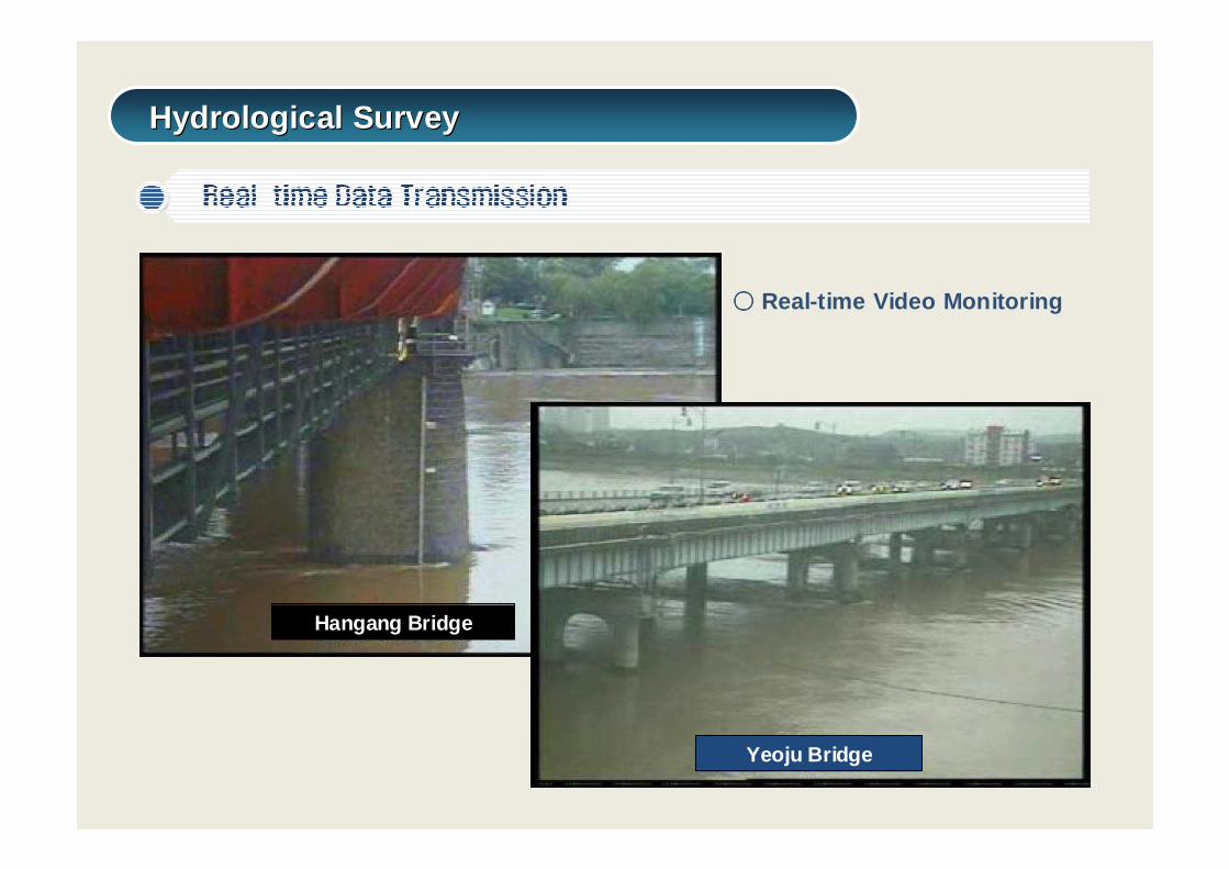
Hangang Bridge
Yeoju Bridge
○○○○ Real-time Video Monitoring
Hydrological SurveyHydrological Survey
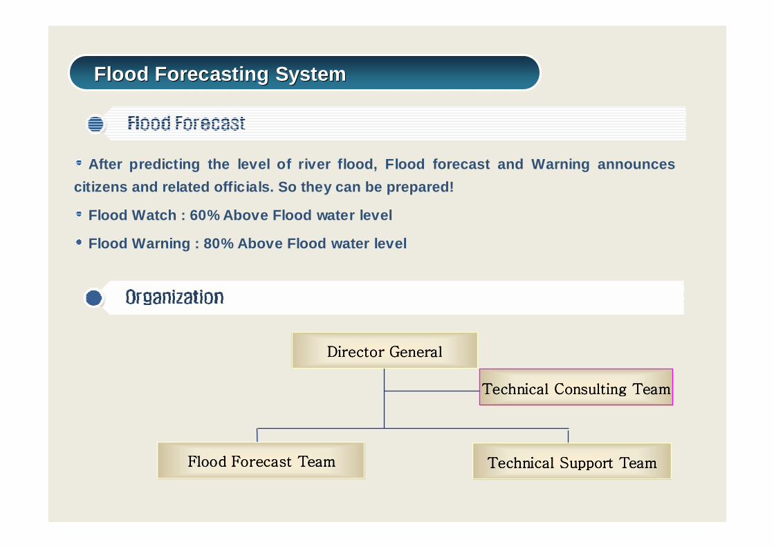
Director GeneralDirector GeneralDirector GeneralDirector General
Flood Forecast TeamFlood Forecast TeamFlood Forecast TeamFlood Forecast Team
Technical Consulting TeamTechnical Consulting TeamTechnical Consulting TeamTechnical Consulting Team
Technical Support TeamTechnical Support TeamTechnical Support TeamTechnical Support Team
After predicting the level of river flood, Flood fo recast and Warning announces
citizens and related officials. So they can be prep ared!
Flood Watch : 60% Above Flood water level
Flood Warning : 80% Above Flood water level
Flood Forecasting SystemFlood Forecasting System
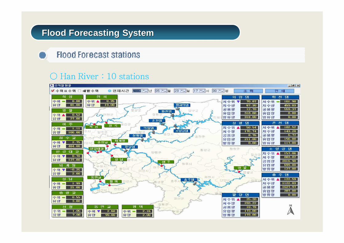
○○○○ Han River : 10Han River : 10Han River : 10Han River : 10 stationsstationsstationsstations
Flood Forecasting SystemFlood Forecasting System
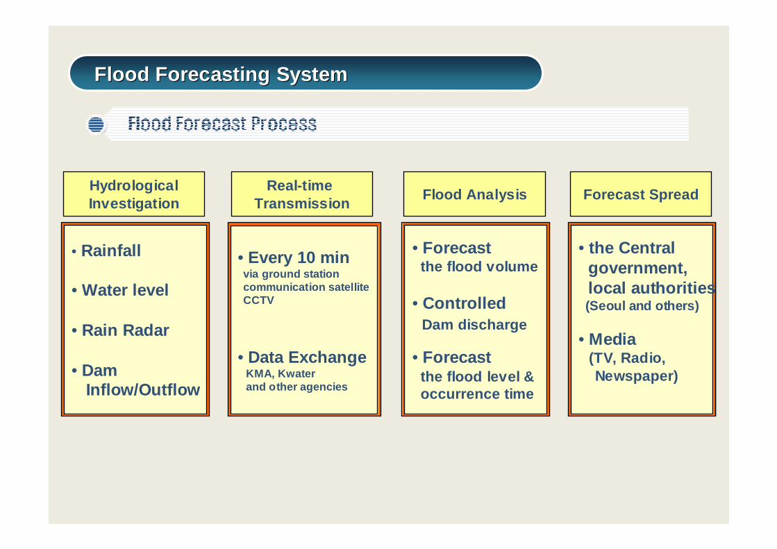
• Every 10 minvia ground stationcommunication satelliteCCTV
• Data ExchangeKMA, Kwater and other agencies
Real-time Transmission
• Forecast the flood volume
• Controlled Dam discharge
• Forecast the flood level &occurrence time
Flood Analysis
• Rainfall
• Water level
• Rain Radar
• Dam Inflow/Outflow
HydrologicalInvestigation
• the Central government,local authorities(Seoul and others)
• Media(TV, Radio, Newspaper)
Forecast Spread
Flood Forecasting SystemFlood Forecasting System
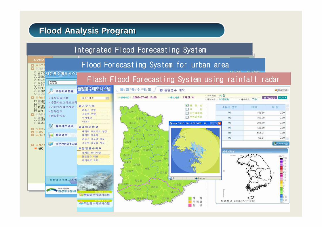
Integrated Flood Forecasting SystemIntegrated Flood Forecasting SystemIntegrated Flood Forecasting SystemIntegrated Flood Forecasting System
ChannelChannelChannelChannel SubbasinSubbasinSubbasinSubbasin ChannelChannelChannelChannel----RoutingRoutingRoutingRouting
Flood Forecasting System for urban areaFlood Forecasting System for urban areaFlood Forecasting System for urban areaFlood Forecasting System for urban area
Flash Flood Forecasting System using rainfall radarFlash Flood Forecasting System using rainfall radarFlash Flood Forecasting System using rainfall radarFlash Flood Forecasting System using rainfall radar
Flood Analysis ProgramFlood Analysis Program
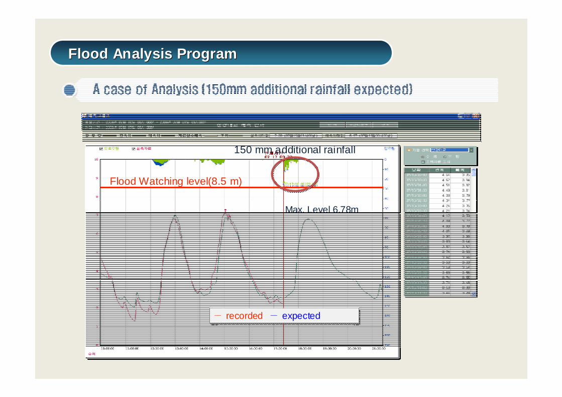
Flood Watching level(8.5 m)
― recorded ― expected― recorded ― expected
Max. Level 6.78m
150 mm additional rainfall
Flood Analysis ProgramFlood Analysis Program
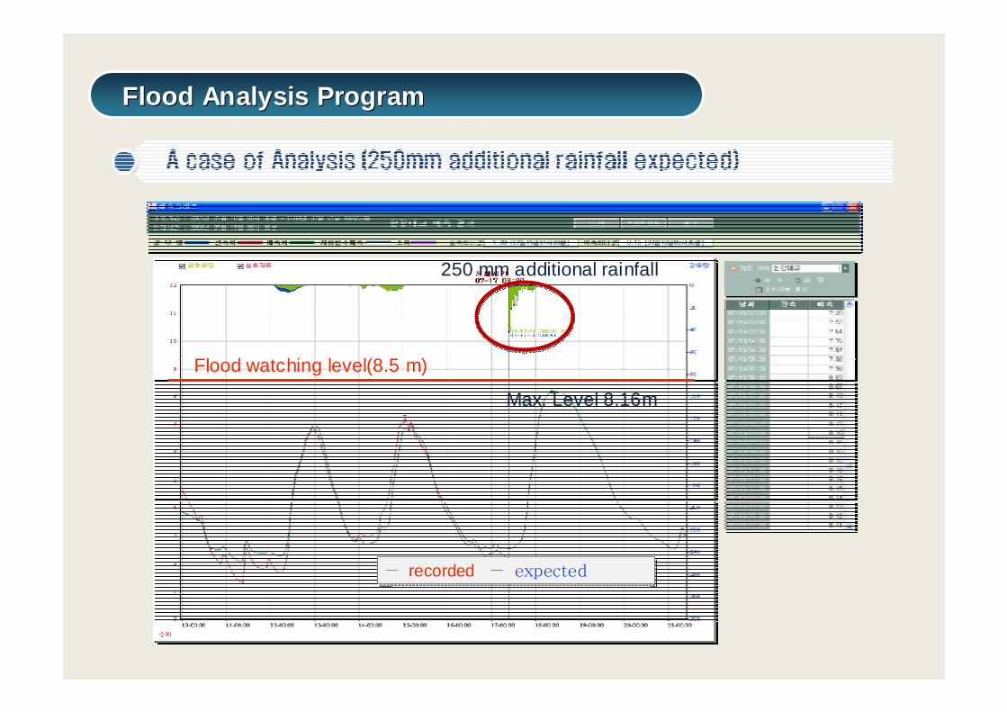
Flood watching level(8.5 m)
― recorded ― expected― recorded ― expected
Max. Level 8.16m
250 mm additional rainfall
Flood Analysis ProgramFlood Analysis Program
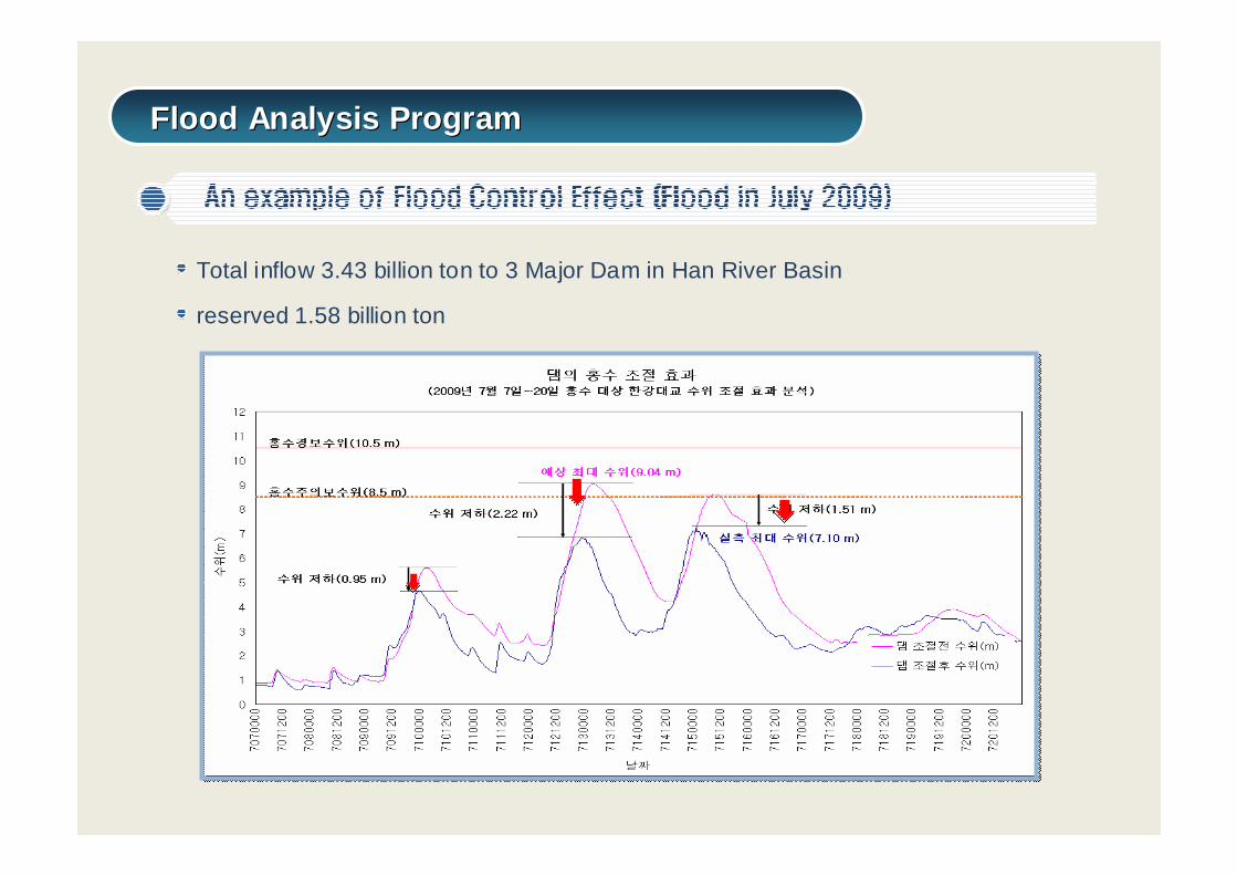
Total inflow 3.43 billion ton to 3 Major Dam in Han River Basin
reserved 1.58 billion ton
Flood Analysis ProgramFlood Analysis Program
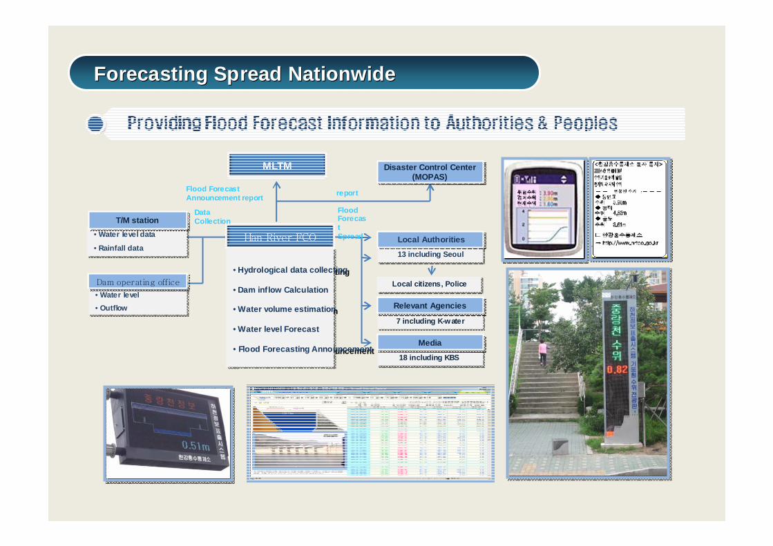
MLTM
Han River FCO
Disaster Control Center(MOPAS)
Disaster Control Center(MOPAS)
13 including Seoul 13 including Seoul
Local AuthoritiesLocal Authorities
Local citizens, PoliceLocal citizens, Police
7 including K-water7 including K-water
Relevant AgenciesRelevant Agencies
18 including KBS 18 including KBS
MediaMedia
• Hydrological data collecting
• Dam inflow Calculation
• Water volume estimation
• Water level Forecast
• Flood Forecasting Announcement
• Hydrological data collecting
• Dam inflow Calculation
• Water volume estimation
• Water level Forecast
• Flood Forecasting Announcement
• Water level data
• Rainfall data
• Water level data
• Rainfall data
T/M stationT/M station
• Water level
• Outflow
• Water level
• Outflow
Dam operating officeDam operating office
reportFlood ForecastAnnouncement report
FloodForecastSpread
DataCollection
Forecasting Spread NationwideForecasting Spread Nationwide
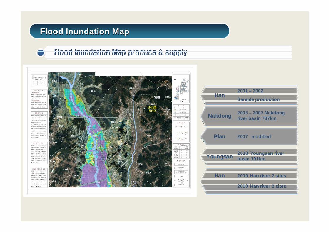
Flood Inundation MapFlood Inundation Map
Han2001 – 2002
Sample production
Nakdong 2003 – 2007 Nakdong river basin 787km
PlanPlan 2007 modified
Youngsan2008 Youngsan river basin 191km
Han 2009 Han river 2 sites
2010 Han river 2 sites
Water Resources Information ManagementWater Resources Information Management
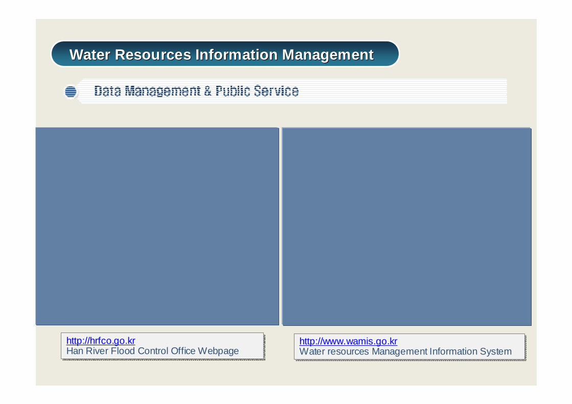
http://www.wamis.go.krWater resources Management Information Systemhttp://www.wamis.go.krWater resources Management Information System
http://hrfco.go.krHan River Flood Control Office Webpagehttp://hrfco.go.krHan River Flood Control Office Webpage
Water Resources Information ManagementWater Resources Information Management
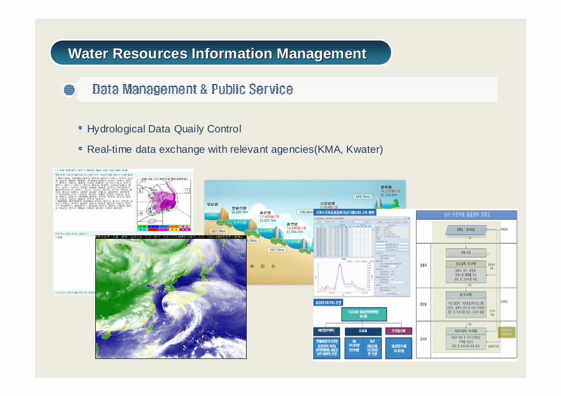
Hydrological Data Quaily Control
Real-time data exchange with relevant agencies(KMA, Kwater)
Water Resources Information ManagementWater Resources Information Management
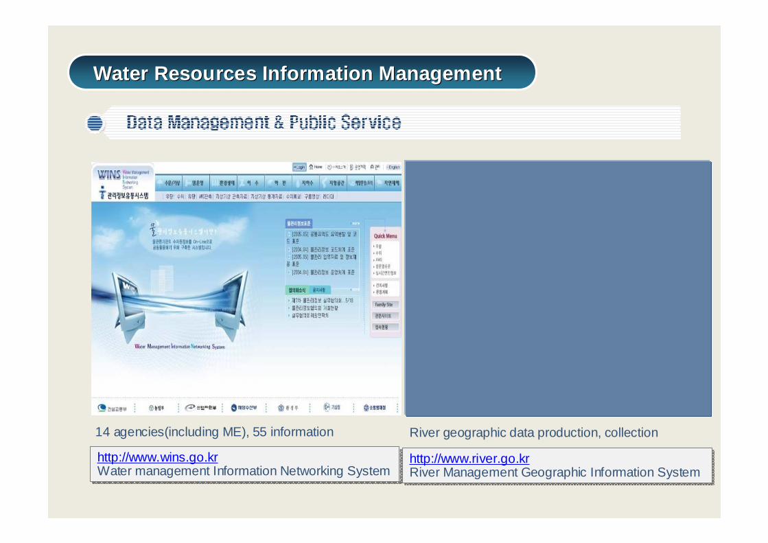
http://www.wins.go.krWater management Information Networking Systemhttp://www.wins.go.krWater management Information Networking System
14 agencies(including ME), 55 information
http://www.river.go.krRiver Management Geographic Information Systemhttp://www.river.go.krRiver Management Geographic Information System
River geographic data production, collection