Embed Size (px)
Citation preview
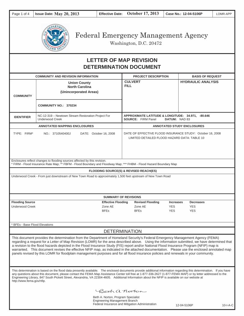
Case No.: Page 1 of 4 Effective Date: Issue Date: LOMR-APP12-04-5106P
Washington, D.C. 20472Federal Emergency Management Agency
LETTER OF MAP REVISION DETERMINATION DOCUMENT
COMMUNITY AND REVISION INFORMATION PROJECT DESCRIPTION
COMMUNITY
APPROXIMATE LATITUDE & LONGITUDE: 34.971, -80.646SOURCE: FIRM Panel DATUM: NAD 83
Union County North Carolina
(Unincorporated Areas)
COMMUNITY NO.: 370234
BASIS OF REQUEST
IDENTIFIER
CULVERTFILL
HYDRAULIC ANALYSIS
NC-12-319 – Newtown Stream Restoration Project For Underwood Creek
ANNOTATED MAPPING ENCLOSURES ANNOTATED STUDY ENCLOSURES
DATE: October 16, 2008 NO.: 3710540400J TYPE: FIRM* DATE OF EFFECTIVE FLOOD INSURANCE STUDY: October 16, 2008 LIMITED DETAILED FLOOD HAZARD DATA: TABLE 10
Enclosures reflect changes to flooding sources affected by this revision. * FIRM - Flood Insurance Rate Map; ** FBFM - Flood Boundary and Floodway Map; *** FHBM - Flood Hazard Boundary Map
FLOODING SOURCE(S) & REVISED REACH(ES)
Underwood Creek - From just downstream of New Town Road to approximately 1,500 feet upstream of New Town Road
SUMMARY OF REVISIONS Revised Flooding Effective Flooding Flooding Source Increases Decreases
Underwood Creek Zone AE Zone AE YES YES BFEs BFEs YES YES
* BFEs - Base Flood Elevations
DETERMINATIONThis document provides the determination from the Department of Homeland Security's Federal Emergency Management Agency (FEMA) regarding a request for a Letter of Map Revision (LOMR) for the area described above. Using the information submitted, we have determined that a revision to the flood hazards depicted in the Flood Insurance Study (FIS) report and/or National Flood Insurance Program (NFIP) map is warranted. This document revises the effective NFIP map, as indicated in the attached documentation. Please use the enclosed annotated map panels revised by this LOMR for floodplain management purposes and for all flood insurance policies and renewals in your community.
This determination is based on the flood data presently available. The enclosed documents provide additional information regarding this determination. If you have any questions about this document, please contact the FEMA Map Assistance Center toll free at 1-877-336-2627 (1-877-FEMA MAP) or by letter addressed to the Engineering Library, 847 South Pickett Street, Alexandria, VA 22304-4605. Additional Information about the NFIP is available on our website at http://www.fema.gov/nfip.
12-04-5106P 10-I-A-C
Beth A. Norton, Program Specialist Engineering Management Branch Federal Insurance and Mitigation Administration
May 20, 2013 October 17, 2013
Case No.: Page 2 of 4 Effective Date: Issue Date: LOMR-APP12-04-5106P
Washington, D.C. 20472Federal Emergency Management Agency
LETTER OF MAP REVISION DETERMINATION DOCUMENT (CONTINUED)
COMMUNITY INFORMATION
APPLICABLE NFIP REGULATIONS/COMMUNITY OBLIGATION
COMMUNITY REMINDERS
This determination is based on the flood data presently available. The enclosed documents provide additional information regarding this determination. If you have any questions about this document, please contact the FEMA Map Assistance Center toll free at 1-877-336-2627 (1-877-FEMA MAP) or by letter addressed to the Engineering Library, 847 South Pickett Street, Alexandria, VA 22304-4605. Additional Information about the NFIP is available on our website at http://www.fema.gov/nfip.
12-04-5106P 102-I-A-C
Beth A. Norton, Program Specialist Engineering Management Branch Federal Insurance and Mitigation Administration
May 20, 2013 October 17, 2013
Case No.: Page 3 of 4 Effective Date: Issue Date: LOMR-APP12-04-5106P
Washington, D.C. 20472Federal Emergency Management Agency
LETTER OF MAP REVISION DETERMINATION DOCUMENT (CONTINUED)
STATUS OF THE COMMUNITY NFIP MAPS
This determination is based on the flood data presently available. The enclosed documents provide additional information regarding this determination. If you have any questions about this document, please contact the FEMA Map Assistance Center toll free at 1-877-336-2627 (1-877-FEMA MAP) or by letter addressed to the Engineering Library, 847 South Pickett Street, Alexandria, VA 22304-4605. Additional Information about the NFIP is available on our website at http://www.fema.gov/nfip.
12-04-5106P 102-I-A-C
Beth A. Norton, Program Specialist Engineering Management Branch Federal Insurance and Mitigation Administration
May 20, 2013 October 17, 2013
Case No.: Page 4 of 4 Effective Date: Issue Date: LOMR-APP12-04-5106P
Washington, D.C. 20472Federal Emergency Management Agency
LETTER OF MAP REVISION DETERMINATION DOCUMENT (CONTINUED)
PUBLIC NOTIFICATION OF REVISION
Federal Register
The Enquirer JournalJune 12, 2013 and June 19, 2013
This determination is based on the flood data presently available. The enclosed documents provide additional information regarding this determination. If you have any questions about this document, please contact the FEMA Map Assistance Center toll free at 1-877-336-2627 (1-877-FEMA MAP) or by letter addressed to the Engineering Library, 847 South Pickett Street, Alexandria, VA 22304-4605. Additional Information about the NFIP is available on our website at http://www.fema.gov/nfip.
12-04-5106P 102-I-A-C
Beth A. Norton, Program Specialist Engineering Management Branch Federal Insurance and Mitigation Administration
May 20, 2013 October 17, 2013
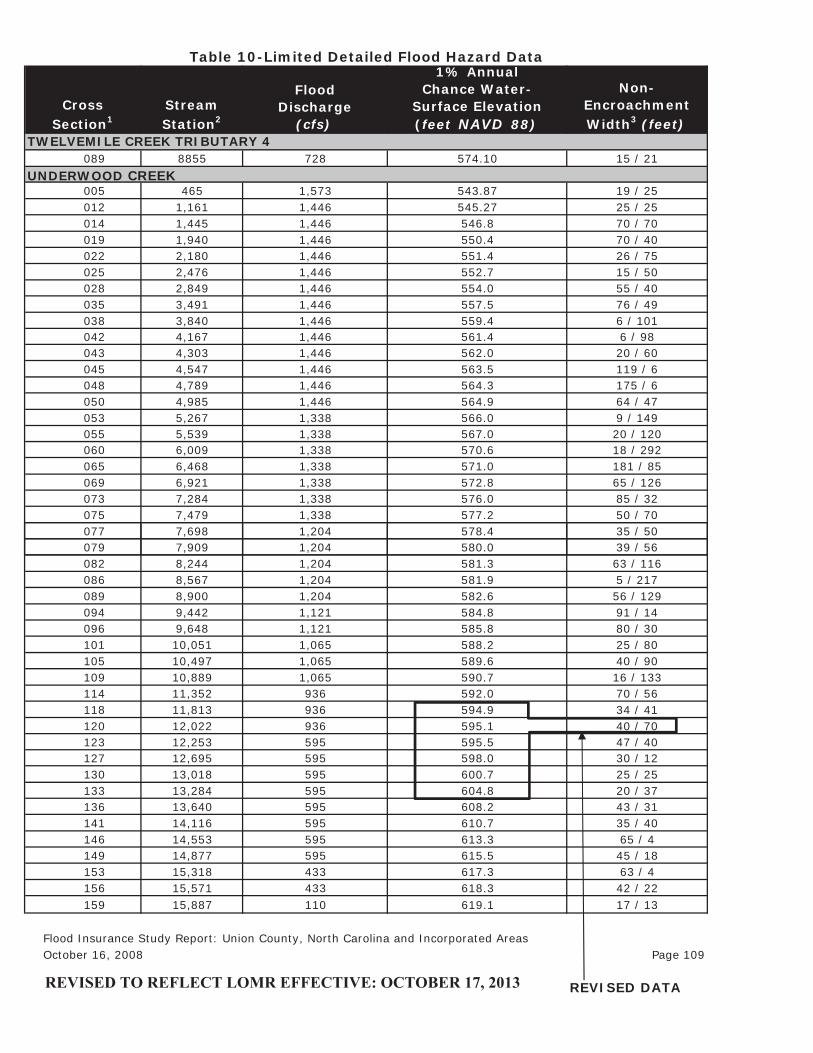
CrossSection1
StreamStation2
FloodDischarge
(cfs)
1% AnnualChance Water-
Surface Elevation(feet NAVD 88)
Non-EncroachmentWidth3 (feet)
089 8855 728 574.10 15 / 21
005 465 1,573 543.87 19 / 25012 1,161 1,446 545.27 25 / 25014 1,445 1,446 546.8 70 / 70019 1,940 1,446 550.4 70 / 40022 2,180 1,446 551.4 26 / 75025 2,476 1,446 552.7 15 / 50028 2,849 1,446 554.0 55 / 40035 3,491 1,446 557.5 76 / 49038 3,840 1,446 559.4 6 / 101042 4,167 1,446 561.4 6 / 98043 4,303 1,446 562.0 20 / 60045 4,547 1,446 563.5 119 / 6048 4,789 1,446 564.3 175 / 6050 4,985 1,446 564.9 64 / 47053 5,267 1,338 566.0 9 / 149055 5,539 1,338 567.0 20 / 120060 6,009 1,338 570.6 18 / 292065 6,468 1,338 571.0 181 / 85069 6,921 1,338 572.8 65 / 126073 7,284 1,338 576.0 85 / 32075 7,479 1,338 577.2 50 / 70077 7,698 1,204 578.4 35 / 50
UNDERWOOD CREEK
Table 10-Limited Detailed Flood Hazard Data
TWELVEMILE CREEK TRIBUTARY 4
079 7,909 1,204 580.0 39 / 56082 8,244 1,204 581.3 63 / 116086 8,567 1,204 581.9 5 / 217089 8,900 1,204 582.6 56 / 129094 9,442 1,121 584.8 91 / 14096 9,648 1,121 585.8 80 / 30101 10,051 1,065 588.2 25 / 80105 10,497 1,065 589.6 40 / 90109 10,889 1,065 590.7 16 / 133114 11,352 936 592.0 70 / 56118 11,813 936 594.9 34 / 41120 12,022 936 595.1 40 / 70123 12,253 595 595.5 47 / 40127 12,695 595 598.0 30 / 12130 13,018 595 600.7 25 / 25133 13,284 595 604.8 20 / 37136 13,640 595 608.2 43 / 31141 14,116 595 610.7 35 / 40146 14,553 595 613.3 65 / 4149 14,877 595 615.5 45 / 18153 15,318 433 617.3 63 / 4156 15,571 433 618.3 42 / 22159 15,887 110 619.1 17 / 13
Flood Insurance Study Report: Union County, North Carolina and Incorporated Areas October 16, 2008 Page 109
REVISED DATAREVISED TO REFLECT LOMR EFFECTIVE: OCTOBER 17, 2013
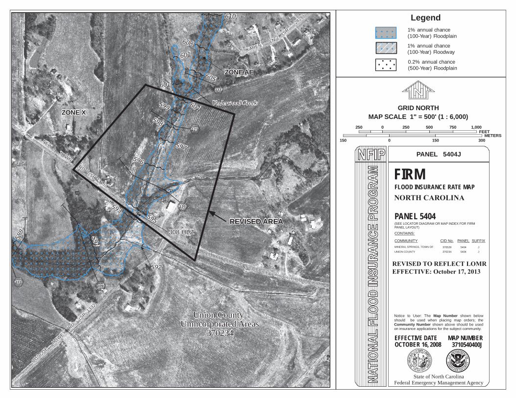
NEW
TOWNRD
ROSCOEHOWEY
RD(S
R13
32)
KARENLN
(SR
2826)
ZONE X
596
591
595
593
61058
8
601599
605
597
601
601
308 HLZ
P .
i109
P .
i120
P .
i133
P.
i101
608
P .
i127
592
ZONE AE
(SR 1315)
598
Union CountyUnincorporated Areas
370234
Underwood Creek
250 0 250 500 750 1,000FEET
150 0 150 300METERS
GRID NORTHMAP SCALE 1" = 500' (1 : 6,000)
REVISED AREA
Legend1% annual chance(100-Year) Floodplain
1% annual chance(100-Year) Floodway
0.2% annual chance(500-Year) Floodplain
NORTH CAROLINA
370529 5404 J
UNION COUNTY 370234 5404 J
PANEL 5404J
FIRMFLOOD INSURANCE RATE MAP
PANEL 5404(SEE LOCATOR DIAGRAM OR MAP INDEX FOR FIRMPANEL LAYOUT)
CONTAINS:
COMMUNITY CID No. PANEL SUFFIX
Notice to User: The Map Number shown belowshould be used when placing map orders; theCommunity Number shown above should be usedon insurance applications for the subject community.
EFFECTIVE DATE MAP NUMBER3710540400J
State of North CarolinaFederal Emergency Management Agency
MINERAL SPRINGS, TOWN OF
OCTOBER 16, 2008
REVISED TO REFLECT LOMREFFECTIVE: October 17, 2013