Embed Size (px)
Citation preview
Wapiti River Watershed Study
A Fisheries Management Enhancement Project Alberta Conservation Association
By Paul J. Hvenegaard
Northwest Boreal Region Peace River, Alberta
March, 2001
Alberta Conservation Association Wapiti River Watershed Study
Year One 2000-2001
DRAFT Progress Report i
ACKNOWLEDGEMENTS
This study was funded by Alberta’s anglers through the Fisheries Management Enhancement Program of the Alberta Conservation Association (ACA) and Alliance Pipeline Ltd. Messrs. Trevor Thera (ACA, Regional Programs Manager), Travis Ripley and David Walty (Alberta Environment) aided in the development of the project and critical review of this manuscript. The following individuals and their affiliation are recognised for many in-kind and logistical support items and services:
Alberta Conservation Association staff members, Messrs., A. Wildeman, L. Osokin, J. Hallet
Alliance Pipeline, Mr. Paul Anderson
Alberta Environment: -Natural Resources Service, Fish & Wildlife Management Division,
Mr. D. Schroeder
- Land and Forest Service, Regional Resource Mapping Unit, Ms. R. Sprado
Department of Fisheries and Oceans Canada, Mr. Earl Jessop
Alberta Conservation Association Wapiti River Watershed Study
Year One 2000-2001
DRAFT Progress Report ii
TABLE OF CONTENTS
ACKNOWLEDGEMENTS ................................................................................................... i
TABLE OF CONTENTS ..................................................................................................... ii
LIST OF TABLES ............................................................................................................. iii
LIST OF FIGURES ............................................................................................................ iv
EXECUTIVE SUMMARY .................................................................................................... v
1.0 INTRODUCTION .......................................................................................................... 1
A. Wapiti River ................................................................................................................ 2 B. Redwillow River ........................................................................................................ 2 C. Beaverlodge River ..................................................................................................... 2
2.0 STUDY AREA .............................................................................................................. 3
3.0 METHODS .................................................................................................................... 4
3.1 Fish Trap .................................................................................................................. 4 3.2 Electrofishing ............................................................................................................ 5 3.3 Radio Telemetry ....................................................................................................... 6 3.4 Habitat Description ................................................................................................... 7 3.5 Data Management .................................................................................................... 7
4.0 RESULTS ..................................................................................................................... 8
4.1 Redwillow River Fish Trap ....................................................................................... 8 4.1.1 Arctic Grayling ............................................................................................... 9 4.2 Radio Telemetry ..................................................................................................... 10 4.2.1 Redwillow River Arctic Grayling Spawning Movements ............................. 10 4.2.2 Wapiti River Bull Trout Spawning Movements ............................................ 11 4.2.3 Bull Trout and Arctic Grayling Overwintering .............................................. 13 4.3 Electrofishing Surveys ............................................................................................ 15 4.3.1 Tributary Sampling ...................................................................................... 15 4.3.2 Wapiti River Sampling ................................................................................. 17
5.0 DISCUSSION ............................................................................................................. 25
5.1 Wapiti River ............................................................................................................ 25 5.2 Redwillow River ...................................................................................................... 25 5.3 Beaverlodge River .................................................................................................. 26
6.0 LITERATURE CITED ................................................................................................. 27
7.0 APPENDICES ........................................................................................................... 29
Appendix A: Redwillow Trap Daily Catch Records ...................................................... 29 Appendix B: Redwillow River Fish Trap Fish Measurement Data ............................... 30 Appendix C: Radio Transmittered Fish Data ............................................................... 37
Alberta Conservation Association Wapiti River Watershed Study
Year One 2000-2001
DRAFT Progress Report iii
LIST OF TABLES
Table 1. Fish species captured in the Redwillow River trap, 2000. .................................. 8
Table 2. Mean length at age (mm) of Arctic grayling captured at the Redwillow Trap, 2000. (Data in parentheses denotes sample size) .......................................................... 10
Table 3. Catch and effort summary for electrofishing surveys in the Redwillow and Beaverlodge watersheds. ................................................................................................. 17
Table 4. Catch1and effort summary for electrofishing surveys in the mainstem Wapiti River. ................................................................................................................................ 18
Table 5. Mean length at age (mm) of Arctic grayling and mountain whitefish captured during mainstem Wapiti River electrofishing surveys. (Data in parentheses denotes sample size)...................................................................................................................... 19
Table 6. Habitat data on inventory sites in the Beaverlodge and Redwillow River watersheds May and June 2000. ..................................................................................... 23
Alberta Conservation Association Wapiti River Watershed Study
Year One 2000-2001
DRAFT Progress Report iv
LIST OF FIGURES
Figure 1. Wapiti River Watershed Study Area. .................................................................. 3
Figure 2. Historical Wapiti River Discharge Records (1961-1998) and for the 2000 Study Year. Source: Environment Canada (2000) ....................................................................... 4
Figure 3. Location of fish trap in the Redwillow River, 2000. ........................................... 5
Figure 4. Species composition of fish captured at the Redwillow River fish trap during spring, 2000. ....................................................................................................................... 8
Figure 5. Daily Arctic grayling catch and mean daily water temperature at the Redwillow River fish trap, spring 2000. ................................................................................................ 9
Figure 6. Length frequency distribution of Arctic grayling captured at the Redwillow fish trap, spring 2000. .............................................................................................................. 10
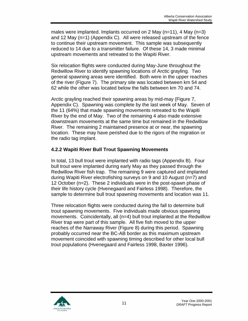
Figure 7. Arctic grayling spawning locations in the Redwillow River, spring 2000. ........ 12
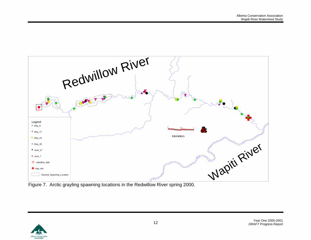
Figure 8. Bull trout spawning locations in the Narraway River, fall 2000. ...................... 13
Figure 9. Bull trout overwintering locations in the mainstem Wapiti River, winter 2000-2001. ................................................................................................................................. 14
Figure 10. Arctic grayling overwintering locations in the mainstem Wapiti River winter 2000-2001......................................................................................................................... 15
Figure 11. Inventory sites conducted during May and June 2000 in the Redwillow and Beaverlodge River watersheds. ....................................................................................... 16
Figure 12. Electrofishing sample reaches on the mainstem Wapiti River 2000. ............ 18
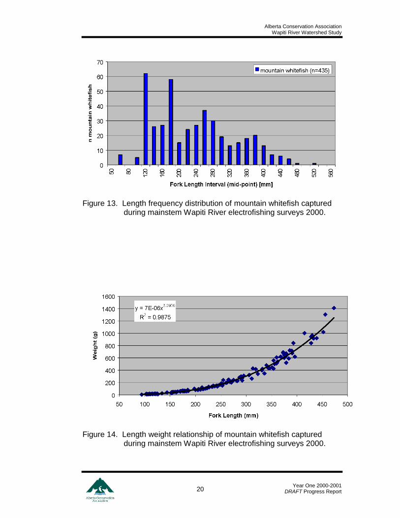
Figure 13. Length frequency distribution of mountain whitefish captured during mainstem Wapiti River electrofishing surveys 2000. ........................................................ 20
Figure 14. Length weight relationship of mountain whitefish captured during mainstem Wapiti River electrofishing surveys 2000. ........................................................................ 20
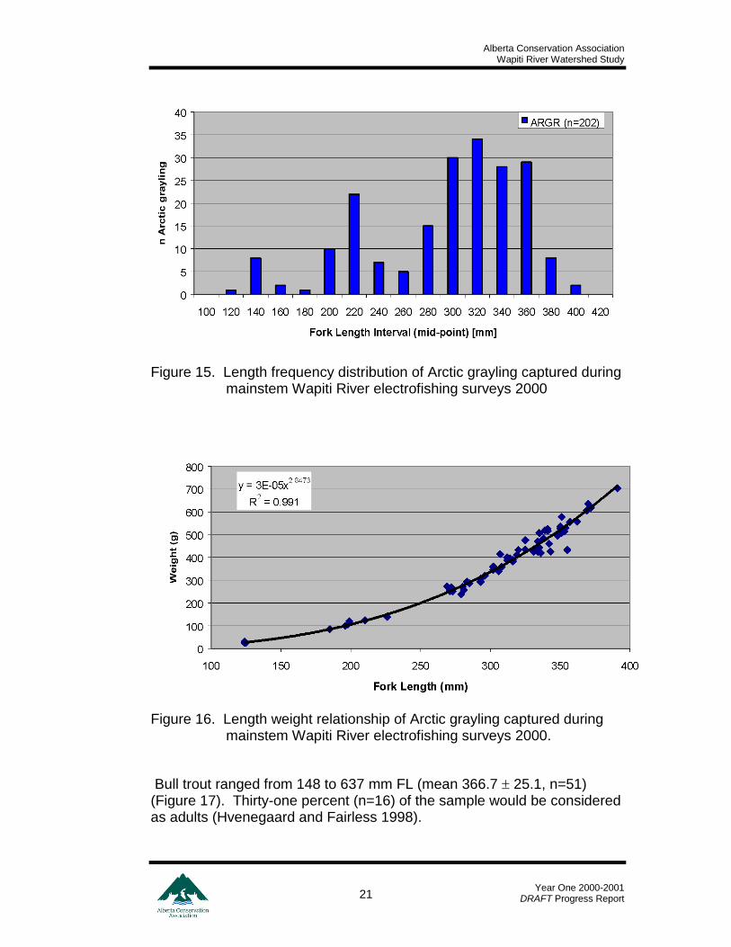
Figure 15. Length frequency distribution of Arctic grayling captured during mainstem Wapiti River electrofishing surveys 2000 ......................................................................... 21
Figure 16. Length weight relationship of Arctic grayling captured during mainstem Wapiti River electrofishing surveys 2000. ................................................................................... 21
Figure 17. Length frequency distribution of bull trout captured during mainstem Wapiti River electrofishing surveys 2000. ................................................................................... 22
Figure 18. Land ownership within the Redwillow River riparian area. ............................ 24
Figure 19. Historical and current discharge data for the Beaverlodge River. .................. 26
Alberta Conservation Association Wapiti River Watershed Study
Year One 2000-2001
DRAFT Progress Report v
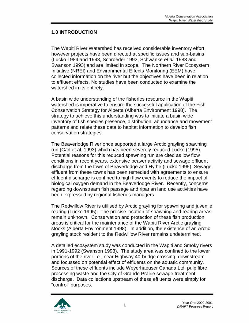
EXECUTIVE SUMMARY
During 2000 –2001, data on fish and fish habitat were collected on the Wapiti, Beaverlodge and Redwillow river to satisfy specific informational needs for each river. In the Wapiti River, radio transmittered bull trout selected areas in the upper Narraway River for spawning and overwintered in the general vicinity of the Narraway River mouth plus the effluent areas of the lower Wapiti River. Radio transmittered Arctic grayling overwintered in the mouth areas of 3 prominent creeks. Electrofishing surveys indicated that mountain whitefish, Arctic grayling and bull trout were the most abundant sportfish. Highest abundance of sportfish occurred in the upper reach of the Wapiti River. In the spring of 2000, more than 200 Arctic grayling were enumerated with a fish trap and fence constructed in the Redwillow River. A select sample was implanted with radio transmitters to facilitate movement monitoring. The upstream migration commenced in late April, peaked in early May and was complete by mid May. Spawning occurred in the upper reaches of the Redwillow River downstream of an impassable set of falls. By the end of May, most Arctic grayling had retreated to the Wapiti River. Numerous beaver dams in the Beaverlodge River prevented any migration of Arctic grayling. No Arctic grayling were captured throughout the Beaverlodge and Redwillow sub-basins and sportfish were extremely rare. All inventory sites in the Beaverlodge sub-basin were rated as having low potential for spawning and medium to low potential for rearing and overwintering respectively. The Redwillow River sub-basin was characterised by high quality habitat. Priority protection areas and suggestions for future inventory needs are provided.
Alberta Conservation Association Wapiti River Watershed Study
Year One 2000-2001
DRAFT Progress Report 1
1.0 INTRODUCTION
The Wapiti River Watershed has received considerable inventory effort however projects have been directed at specific issues and sub-basins (Lucko 1984 and 1993, Schroeder 1992, Schwanke et al. 1983 and Swanson 1993) and are limited in scope. The Northern River Ecosystem Initiative (NREI) and Environmental Effects Monitoring (EEM) have collected information on the river but the objectives have been in relation to effluent effects. No studies have been conducted to examine the watershed in its entirety. A basin wide understanding of the fisheries resource in the Wapiti watershed is imperative to ensure the successful application of the Fish Conservation Strategy for Alberta (Alberta Environment 1998). The strategy to achieve this understanding was to initiate a basin wide inventory of fish species presence, distribution, abundance and movement patterns and relate these data to habitat information to develop fish conservation strategies. The Beaverlodge River once supported a large Arctic grayling spawning run (Carl et al. 1993) which has been severely reduced Lucko (1995). Potential reasons for this reduced spawning run are cited as low flow conditions in recent years, extensive beaver activity and sewage effluent discharge from the town of Beaverlodge and Hythe (Lucko 1995). Sewage effluent from these towns has been remedied with agreements to ensure effluent discharge is confined to high flow events to reduce the impact of biological oxygen demand in the Beaverlodge River. Recently, concerns regarding downstream fish passage and riparian land use activities have been expressed by regional fisheries managers. The Redwillow River is utilised by Arctic grayling for spawning and juvenile rearing (Lucko 1995). The precise location of spawning and rearing areas remain unknown. Conservation and protection of these fish production areas is critical for the maintenance of the Wapiti River Arctic grayling stocks (Alberta Environment 1998). In addition, the existence of an Arctic grayling stock resident to the Redwillow River remains undetermined. A detailed ecosystem study was conducted in the Wapiti and Smoky rivers in 1991-1992 (Swanson 1993). The study area was confined to the lower portions of the river i.e., near Highway 40-bridge crossing, downstream and focussed on potential effect of effluents on the aquatic community. Sources of these effluents include Weyerhaeuser Canada Ltd. pulp fibre processing waste and the City of Grande Prairie sewage treatment discharge. Data collections upstream of these effluents were simply for “control” purposes.
Alberta Conservation Association Wapiti River Watershed Study
Year One 2000-2001
DRAFT Progress Report 2
Sub-basins of the Wapiti River watershed (within the Weyerhaeuser Canada Forest Management Agreement Area) have received a general level of inventory effort via the Cooperative Fisheries Inventory Program (Hvenegaard 1998). Only 11 fish collections have been recorded in the Provincial Fisheries Management Information System (FMIS) upstream of Highway 40-bridge crossing and 75% (n=8) of these occurred prior to 1985. During 2000-2001, funded by the Fisheries Management Enhancement Program of the Alberta Conservation Association (ACA) and Alliance Pipeline, a multi-year project was initiated to address specific informational needs. These were specific to the mainstem Wapiti River in addition to the Redwillow and Beaverlodge rivers. A data summary of the results of year one (2000-2001) is presented in this report. Objectives specific to year one were to: A. Wapiti River 1. Determine the critical overwintering and spawning areas for bull trout
and Arctic grayling within the watershed. 2. Define seasonal distributions and movement patterns of bull trout and
Arctic grayling throughout the system. 3. Describe the longitudinal species assemblage for the system. B. Redwillow River 1. Determine magnitude of Arctic grayling spawning run into the
Redwillow River. 2. Determine critical spawning areas and movement patterns (timing) of
Arctic grayling in the system. 3. Describe current riparian land-use within the Redwillow River and
relate these data to movement patterns with focus on enhancement opportunities.
C. Beaverlodge River 1. Assess downstream fish passage over the Town of Beaverlodge water
supply weir. 2. Assess suspected historic spawning and overwintering areas for
grayling presence.
Alberta Conservation Association Wapiti River Watershed Study
Year One 2000-2001
DRAFT Progress Report 3
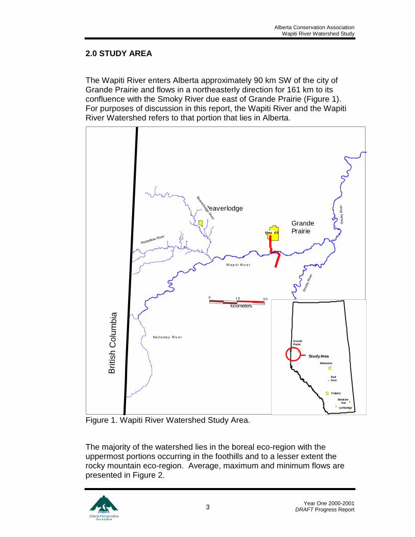
2.0 STUDY AREA
The Wapiti River enters Alberta approximately 90 km SW of the city of Grande Prairie and flows in a northeasterly direction for 161 km to its confluence with the Smoky River due east of Grande Prairie (Figure 1). For purposes of discussion in this report, the Wapiti River and the Wapiti River Watershed refers to that portion that lies in Alberta.
Figure 1. Wapiti River Watershed Study Area.
The majority of the watershed lies in the boreal eco-region with the uppermost portions occurring in the foothills and to a lesser extent the rocky mountain eco-region. Average, maximum and minimum flows are presented in Figure 2.
Beaverlodge
GrandePrairie
Bri
tish C
olu
mb
ia
Na rra wa y Ri v e r
Hwy 4 0
Beaverlodge R
iver
Redwillow River
Sm
oky R
ive
r
Sm
oky
Riv
er
W a p i t i Ri v e r
3 0
kilometers
1 50
Lethbridge
Medicine
Hat
Calgary
Red
Deer
Edmonton
Grande
Prairie
Study Area
Alberta Conservation Association Wapiti River Watershed Study
Year One 2000-2001
DRAFT Progress Report 4
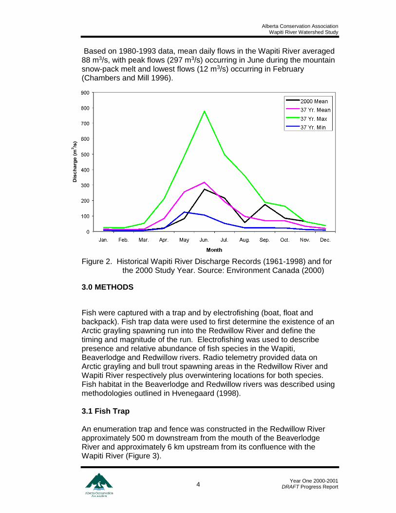
Based on 1980-1993 data, mean daily flows in the Wapiti River averaged 88 m3/s, with peak flows (297 m3/s) occurring in June during the mountain snow-pack melt and lowest flows (12 m3/s) occurring in February (Chambers and Mill 1996).
Figure 2. Historical Wapiti River Discharge Records (1961-1998) and for the 2000 Study Year. Source: Environment Canada (2000)
3.0 METHODS
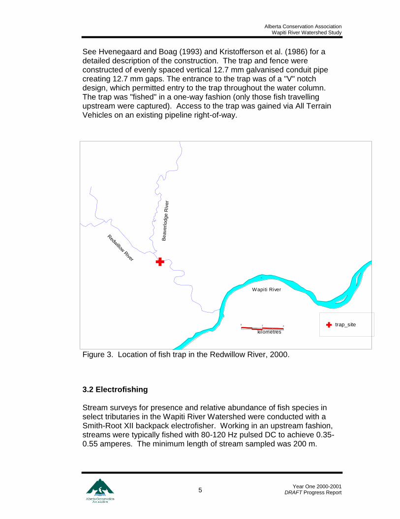
Fish were captured with a trap and by electrofishing (boat, float and backpack). Fish trap data were used to first determine the existence of an Arctic grayling spawning run into the Redwillow River and define the timing and magnitude of the run. Electrofishing was used to describe presence and relative abundance of fish species in the Wapiti, Beaverlodge and Redwillow rivers. Radio telemetry provided data on Arctic grayling and bull trout spawning areas in the Redwillow River and Wapiti River respectively plus overwintering locations for both species. Fish habitat in the Beaverlodge and Redwillow rivers was described using methodologies outlined in Hvenegaard (1998). 3.1 Fish Trap An enumeration trap and fence was constructed in the Redwillow River approximately 500 m downstream from the mouth of the Beaverlodge River and approximately 6 km upstream from its confluence with the Wapiti River (Figure 3).
Alberta Conservation Association Wapiti River Watershed Study
Year One 2000-2001
DRAFT Progress Report 5
See Hvenegaard and Boag (1993) and Kristofferson et al. (1986) for a detailed description of the construction. The trap and fence were constructed of evenly spaced vertical 12.7 mm galvanised conduit pipe creating 12.7 mm gaps. The entrance to the trap was of a "V" notch design, which permitted entry to the trap throughout the water column. The trap was "fished" in a one-way fashion (only those fish travelling upstream were captured). Access to the trap was gained via All Terrain Vehicles on an existing pipeline right-of-way.
Figure 3. Location of fish trap in the Redwillow River, 2000.
3.2 Electrofishing Stream surveys for presence and relative abundance of fish species in select tributaries in the Wapiti River Watershed were conducted with a Smith-Root XII backpack electrofisher. Working in an upstream fashion, streams were typically fished with 80-120 Hz pulsed DC to achieve 0.35-0.55 amperes. The minimum length of stream sampled was 200 m.
trap_site
Wapiti River1
kilometres
0
Wapiti River
2
Redw
illow R
iver
Be
averl
odg
e R
iver
Alberta Conservation Association Wapiti River Watershed Study
Year One 2000-2001
DRAFT Progress Report 6
The upper section of the Wapiti River was sampled with a customised float electrofishing system, which consisted of a Smith-RootTM pulsator mounted in a 4.3 m inflatable river raft. A horizontal plastic conduit pipe containing 1 m long cathode array was attached to each gunwale of the raft. Working in a downstream fashion, likely fish holding water was probed with a 3 m fibreglass pole fixed to a 355 mm diameter stainless steel anode ring. Immobilised fish were retrieved and placed in an aerated fish tub contained in the raft. The electrofishing system was powered by a 5.0 kWh generator and operated at 60 pulses per second (PPS) DC and achieved an output power of 6.0 – 8.0 amperes. The lower section of the Wapiti River was sampled with a Smith-RootTM
16-H electrofishing jetboat. The systems power source was the same as the raft but the hull functioned as the cathode while 2 anode arrays mounted off the bow completed the electrical circuit. 3.3 Radio Telemetry High frequency radio transmitters, or tags, (Global Telemetry SystemsTM) were implanted surgically in adult bull trout and Arctic grayling using methods similar to those described by Bidgood (1980) and McKinley (1992). Minimum size limits were 400 and 350 mm fork length (FL) for bull trout and Arctic grayling respectively. Radio transmitters (149.000 - 149.999 MHz) had a guaranteed operational life of 3.1 years for bull trout and 300 days for Arctic grayling. Relocation flights were conducted every 7 -10 days during the spring (2000) to determine Arctic grayling spawning locations in the Redwillow River monthly throughout the summer and weekly during the fall to determine bull trout spawning movement patterns and locations. Flights were conducted monthly throughout the winter to examine overwintering locations for both species. Fish were located from the air using a four element “Yagi” directional antennae mounted on each side of the aircraft in conjunction with two LotekTM SRX_400 programmable scanning receivers. A fixed wing aircraft (Cessna Cardinal 177) was used for the majority of the flights. A rotary wing aircraft (Bell 206 Jet Ranger) was used on 3 occasions due to safety concerns (altitude and wind) as spawning bull trout selected areas in the western portion of the study area. With both types of aircraft, the flights were conducted 100 -150 m above the river at approximately 150 km/h.
Alberta Conservation Association Wapiti River Watershed Study
Year One 2000-2001
DRAFT Progress Report 7
The point at which the signal strength was highest was deemed the location of each individual fish. Locational data were recorded with a GARMINTM 12 XL field global position system (GPS) receiver. With use of a Geographical Information System, these data were then transformed to river kilometres expressed as the distance upstream from the mouth in the watercourse that the fish were located. 3.4 Habitat Description At fish inventory locations throughout the Redwillow and Beaverlodge river watersheds, fish habitat data were collected with methods described in Hvenegaard (1998). Measured habitat data included stream widths (wet and bankfull) and depths in addition to water temperature. At 5 transects spaced 50 m apart and perpendicular to the thalweg, the width of the wetted portion of the channel (wetted width) was measured (+/- 0.1 m). The bankfull width was defined as the width of the stream between woody vegetation on either bank. Stream depth was measured (+/- 0.01 m) at 3 intervals equally spaced (left, center and right) across each transect. Estimated habitat parameters included substrate composition and bank stability. The percentage of each substrate type [fines (clay, sand and silt <2 mm), small gravel (2-16 mm), large gravel (17-64 mm), cobble (65-256 mm), boulder (>256 mm) and bedrock] was estimated at each of the 3 intervals along each transect. Bank stability was ranked on a scale from 1 (stable), 2 (slightly unstable), 3 (moderately unstable) and 4 (highly unstable). A mark-recapture experiment was scheduled to examine downstream fish passage over the Beaverlodge River water supply weir but was terminated due to negligible stream flows. 3.5 Data Management All captured sportfish were measured to the nearest millimetre (mm) at the fork (FL). Fish that received a radio tag implant, weight was measured with an electronic digital scale to the nearest gram (g). All sportfish >250 mm FL were fixed with an individually numbered FloyTM anchor tag and "adipose clipped" to identify them as fish previously captured. All data collected were recorded on standardised field forms and later copied onto electronic spreadsheet (Microsoft EXCEL). All locational data were “corrected” spatially to reflect location on watercourse. Fish and fish habitat data were then uploaded in to the Fisheries Management Information System (FMIS) under project # 1639. All data analyses were performed with Microsoft EXCEL. Spatial data were analysed and presented with Microsoft MapInfo.
Alberta Conservation Association Wapiti River Watershed Study
Year One 2000-2001
DRAFT Progress Report 8
4.0 RESULTS
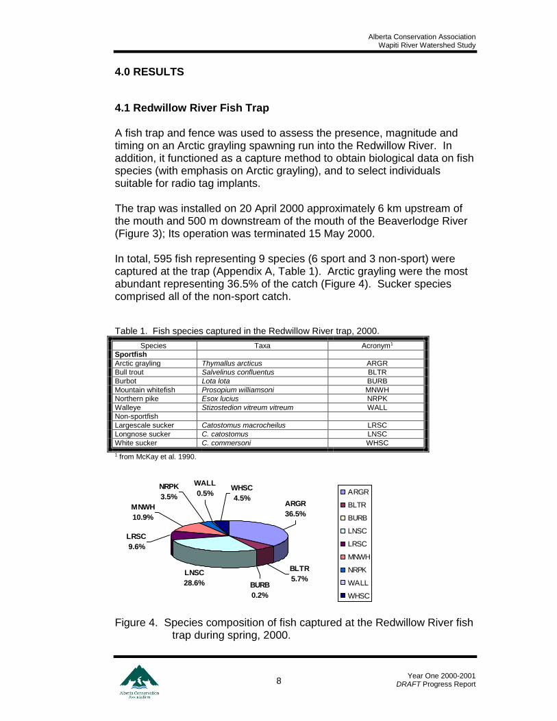
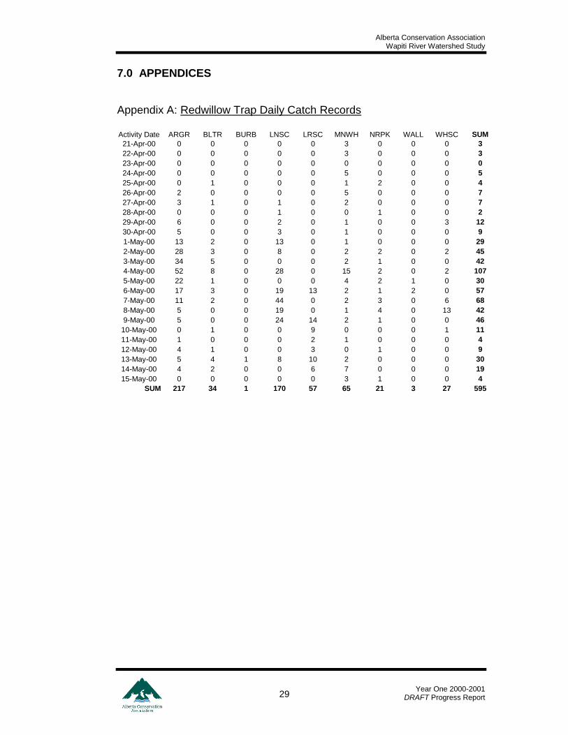
4.1 Redwillow River Fish Trap A fish trap and fence was used to assess the presence, magnitude and timing on an Arctic grayling spawning run into the Redwillow River. In addition, it functioned as a capture method to obtain biological data on fish species (with emphasis on Arctic grayling), and to select individuals suitable for radio tag implants. The trap was installed on 20 April 2000 approximately 6 km upstream of the mouth and 500 m downstream of the mouth of the Beaverlodge River (Figure 3); Its operation was terminated 15 May 2000. In total, 595 fish representing 9 species (6 sport and 3 non-sport) were captured at the trap (Appendix A, Table 1). Arctic grayling were the most abundant representing 36.5% of the catch (Figure 4). Sucker species comprised all of the non-sport catch. Table 1. Fish species captured in the Redwillow River trap, 2000.
Species Taxa Acronym1
Sportfish
Arctic grayling Thymallus arcticus ARGR
Bull trout Salvelinus confluentus BLTR
Burbot Lota lota BURB
Mountain whitefish Prosopium williamsoni MNWH
Northern pike Esox lucius NRPK
Walleye Stizostedion vitreum vitreum WALL
Non-sportfish
Largescale sucker Catostomus macrocheilus LRSC
Longnose sucker C. catostomus LNSC
White sucker C. commersoni WHSC
1 from McKay et al. 1990.
Figure 4. Species composition of fish captured at the Redwillow River fish trap during spring, 2000.
LNSC
28.6%
ARGR
36.5%
NRPK
3.5%
MNWH
10.9%
LRSC
9.6%
WALL
0.5%WHSC
4.5%
BURB
0.2%
BLTR
5.7%
ARGR
BLTR
BURB
LNSC
LRSC
MNWH
NRPK
WALL
WHSC
Alberta Conservation Association Wapiti River Watershed Study
Year One 2000-2001
DRAFT Progress Report 9
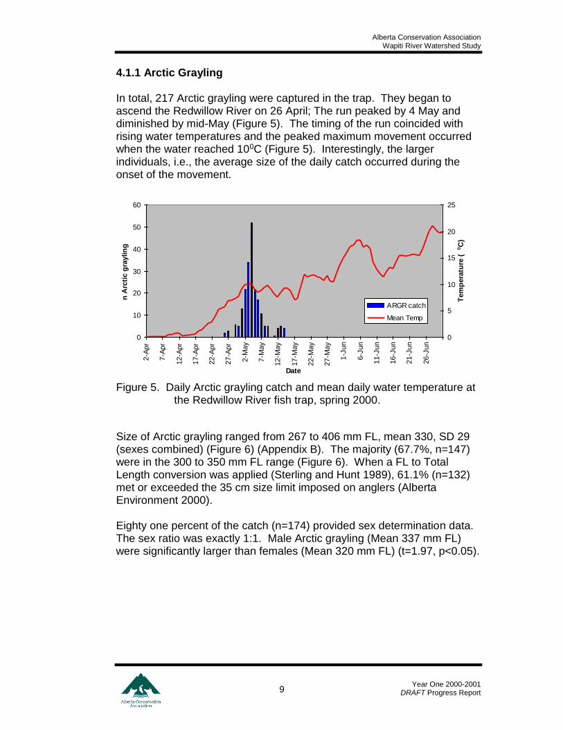
4.1.1 Arctic Grayling In total, 217 Arctic grayling were captured in the trap. They began to ascend the Redwillow River on 26 April; The run peaked by 4 May and diminished by mid-May (Figure 5). The timing of the run coincided with rising water temperatures and the peaked maximum movement occurred when the water reached 100C (Figure 5). Interestingly, the larger individuals, i.e., the average size of the daily catch occurred during the onset of the movement.
Figure 5. Daily Arctic grayling catch and mean daily water temperature at the Redwillow River fish trap, spring 2000.
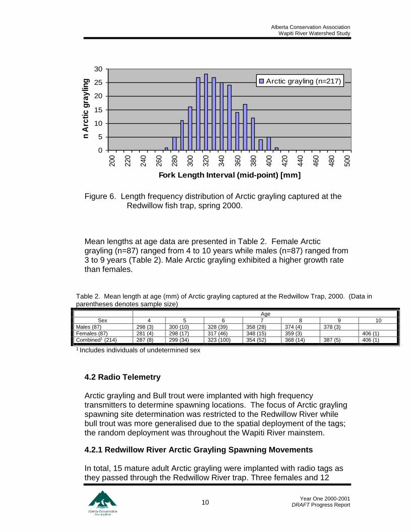
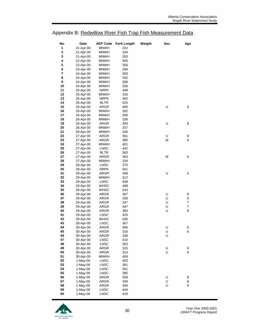
Size of Arctic grayling ranged from 267 to 406 mm FL, mean 330, SD 29 (sexes combined) (Figure 6) (Appendix B). The majority (67.7%, n=147) were in the 300 to 350 mm FL range (Figure 6). When a FL to Total Length conversion was applied (Sterling and Hunt 1989), 61.1% (n=132) met or exceeded the 35 cm size limit imposed on anglers (Alberta Environment 2000). Eighty one percent of the catch (n=174) provided sex determination data. The sex ratio was exactly 1:1. Male Arctic grayling (Mean 337 mm FL) were significantly larger than females (Mean 320 mm FL) (t=1.97, p<0.05).
0
10
20
30
40
50
60
2-A
pr
7-A
pr
12-A
pr
17-A
pr
22-A
pr
27-A
pr
2-M
ay
7-M
ay
12-M
ay
17-M
ay
22-M
ay
27-M
ay
1-J
un
6-J
un
11-J
un
16-J
un
21-J
un
26-J
un
Date
n A
rcti
c g
raylin
g
0
5
10
15
20
25
Tem
pera
ture
(0C
)
ARGR catch
Mean Temp
Alberta Conservation Association Wapiti River Watershed Study
Year One 2000-2001
DRAFT Progress Report 10
Figure 6. Length frequency distribution of Arctic grayling captured at the Redwillow fish trap, spring 2000.
Mean lengths at age data are presented in Table 2. Female Arctic grayling (n=87) ranged from 4 to 10 years while males (n=87) ranged from 3 to 9 years (Table 2). Male Arctic grayling exhibited a higher growth rate than females.
Table 2. Mean length at age (mm) of Arctic grayling captured at the Redwillow Trap, 2000. (Data in parentheses denotes sample size)
Age
Sex 4 5 6 7 8 9 10
Males (87) 298 (3) 300 (10) 328 (39) 358 (28) 374 (4) 378 (3)
Females (87) 281 (4) 298 (17) 317 (46) 348 (15) 359 (3) 406 (1)
Combined1 (214) 287 (8) 299 (34) 323 (100) 354 (52) 368 (14) 387 (5) 406 (1)
1 Includes individuals of undetermined sex
4.2 Radio Telemetry Arctic grayling and Bull trout were implanted with high frequency transmitters to determine spawning locations. The focus of Arctic grayling spawning site determination was restricted to the Redwillow River while bull trout was more generalised due to the spatial deployment of the tags; the random deployment was throughout the Wapiti River mainstem.
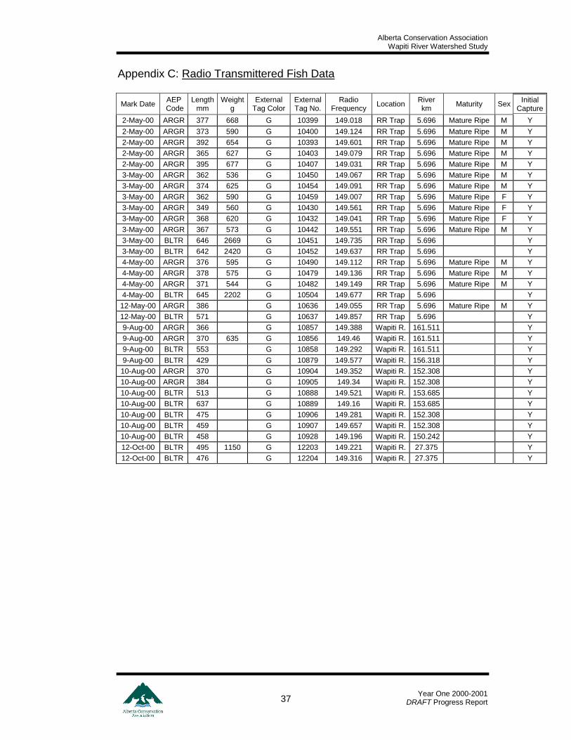
4.2.1 Redwillow River Arctic Grayling Spawning Movements In total, 15 mature adult Arctic grayling were implanted with radio tags as they passed through the Redwillow River trap. Three females and 12
0
5
10
15
20
25
30
200
220
240
260
280
300
320
340
360
380
400
420
440
460
480
500
Fork Length Interval (mid-point) [mm]
n A
rcti
c g
ray
ling Arctic grayling (n=217)
Alberta Conservation Association Wapiti River Watershed Study
Year One 2000-2001
DRAFT Progress Report 11
males were implanted. Implants occurred on 2 May (n=11), 4 May (n=3) and 12 May (n=1) (Appendix C). All were released upstream of the fence to continue their upstream movement. This sample was subsequently reduced to 14 due to a transmitter failure. Of these 14, 3 made minimal upstream movements and retreated to the Wapiti River. Six relocation flights were conducted during May-June throughout the Redwillow River to identify spawning locations of Arctic grayling. Two general spawning areas were identified. Both were in the upper reaches of the river (Figure 7). The primary site was located between km 54 and 62 while the other was located below the falls between km 70 and 74. Arctic grayling reached their spawning areas by mid-may (Figure 7, Appendix C). Spawning was complete by the last week of May. Seven of the 11 (64%) that made spawning movements retreated to the Wapiti River by the end of May. Two of the remaining 4 also made extensive downstream movements at the same time but remained in the Redwillow River. The remaining 2 maintained presence at or near, the spawning location. These may have perished due to the rigors of the migration or the radio tag implant. 4.2.2 Wapiti River Bull Trout Spawning Movements In total, 13 bull trout were implanted with radio tags (Appendix B). Four bull trout were implanted during early May as they passed through the Redwillow River fish trap. The remaining 9 were captured and implanted during Wapiti River electrofishing surveys on 9 and 10 August (n=7) and 12 October (n=2). These 2 individuals were in the post-spawn phase of their life history cycle (Hvenegaard and Fairless 1998). Therefore, the sample to determine bull trout spawning movements and location was 11. Three relocation flights were conducted during the fall to determine bull trout spawning movements. Five individuals made obvious spawning movements. Coincidentally, all (n=4) bull trout implanted at the Redwillow River trap were part of this sample. All five fish moved to the upper reaches of the Narraway River (Figure 8) during this period. Spawning probably occurred near the BC-AB border as this maximum upstream movement coincided with spawning timing described for other local bull trout populations (Hvenegaard and Fairless 1998, Baxter 1996).
Alberta Conservation Association Wapiti River Watershed Study
Year One 2000-2001
DRAFT Progress Report 12
Figure 7. Arctic grayling spawning locations in the Redwillow River spring 2000.
x
Redwillow River
Wapiti
River
5 kilometers
0 2 .5
x
Legend
General_Spawning_Location
trap_site
redwillow_falls
June_7
June_27
May_30
May_24
May_17
May_9
Alberta Conservation Association Wapiti River Watershed Study
Year One 2000-2001
DRAFT Progress Report 13
Figure 8. Bull trout spawning locations in the Narraway River, fall 2000.
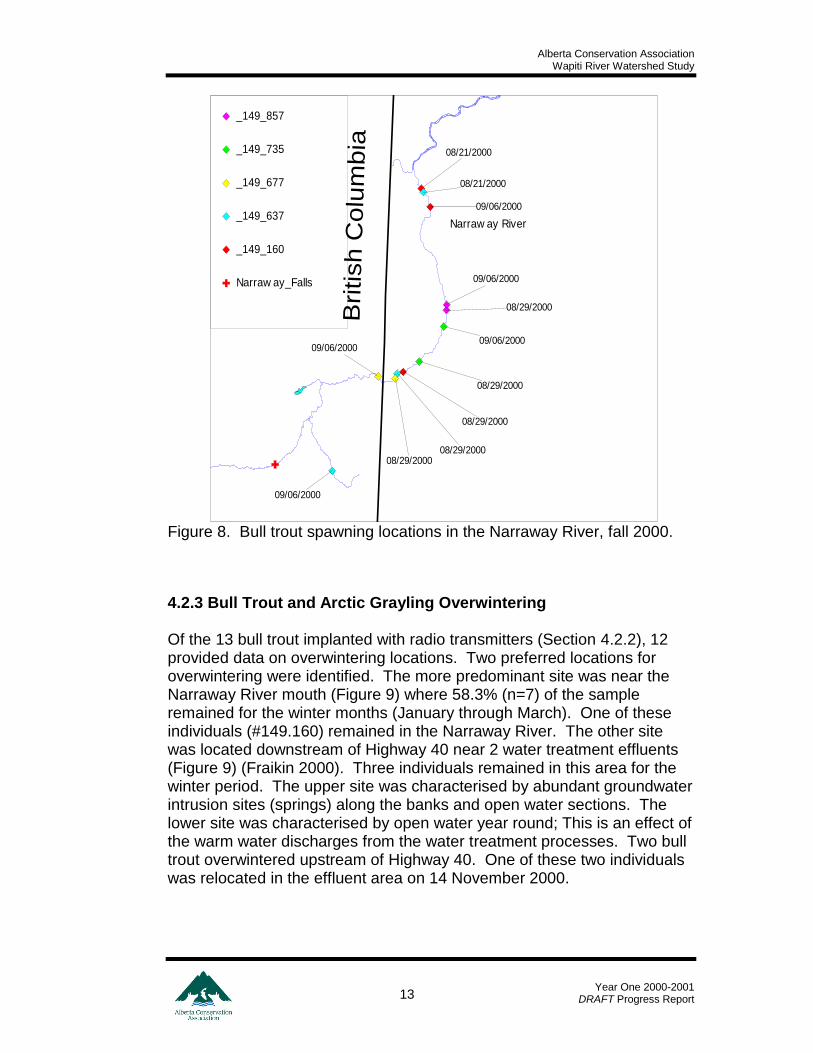
4.2.3 Bull Trout and Arctic Grayling Overwintering Of the 13 bull trout implanted with radio transmitters (Section 4.2.2), 12 provided data on overwintering locations. Two preferred locations for overwintering were identified. The more predominant site was near the Narraway River mouth (Figure 9) where 58.3% (n=7) of the sample remained for the winter months (January through March). One of these individuals (#149.160) remained in the Narraway River. The other site was located downstream of Highway 40 near 2 water treatment effluents (Figure 9) (Fraikin 2000). Three individuals remained in this area for the winter period. The upper site was characterised by abundant groundwater intrusion sites (springs) along the banks and open water sections. The lower site was characterised by open water year round; This is an effect of the warm water discharges from the water treatment processes. Two bull trout overwintered upstream of Highway 40. One of these two individuals was relocated in the effluent area on 14 November 2000.
British C
olu
mbia
Wapiti
River
Narraw ay River
08/29/2000
09/06/2000
08/21/2000
08/29/2000
09/06/2000
08/21/2000
08/29/2000
09/06/2000
08/29/2000
09/06/2000
09/06/2000
08/29/2000
Narraw ay_Falls
_149_160
_149_637
_149_677
_149_735
_149_857
Alberta Conservation Association Wapiti River Watershed Study
Year One 2000-2001
DRAFT Progress Report 14
Figure 9. Bull trout overwintering locations in the mainstem Wapiti River, winter 2000-2001.
Narraway River
Wapiti
River
Smok
y River
4 0
2 0
0 1 0
kilometres
149.316
149.196
149.160149.292
149.657
149.577
149.221
149.316
149.196
149.292
149.657
149.577149.221
149.316
149.857
149.196
149.637
149.160
149.292
149.657
149.735
149.577
149.221
149.316
149.281
149.196
149.677149.637
149.160
149.292
149.657
149.735
149.221
Sew age Treatment Plant Outfall
Weyerhaeuser Mill Outfall
BLTR_Feb_13
BLTR_Feb_27
BLTR_Mar_7
BLTR_Jan_16
Alberta Conservation Association Wapiti River Watershed Study
Year One 2000-2001
DRAFT Progress Report 15
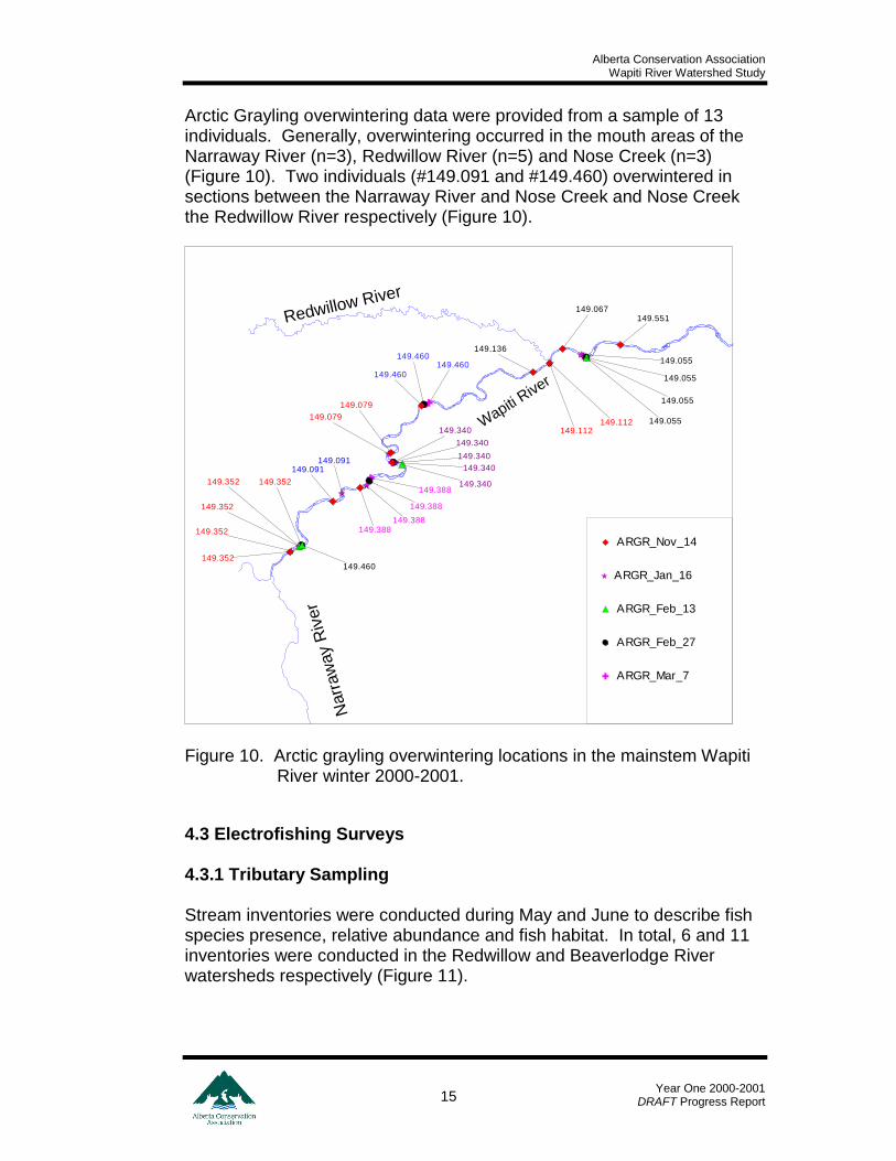
Arctic Grayling overwintering data were provided from a sample of 13 individuals. Generally, overwintering occurred in the mouth areas of the Narraway River (n=3), Redwillow River (n=5) and Nose Creek (n=3) (Figure 10). Two individuals (#149.091 and #149.460) overwintered in sections between the Narraway River and Nose Creek and Nose Creek the Redwillow River respectively (Figure 10).
Figure 10. Arctic grayling overwintering locations in the mainstem Wapiti
River winter 2000-2001.
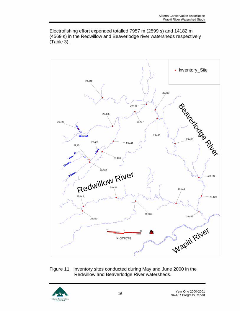
4.3 Electrofishing Surveys 4.3.1 Tributary Sampling Stream inventories were conducted during May and June to describe fish species presence, relative abundance and fish habitat. In total, 6 and 11 inventories were conducted in the Redwillow and Beaverlodge River watersheds respectively (Figure 11).
Wapiti
River
Narr
aw
ay R
iver
Redwillow River
149.340
149.388
149.460
149.352
149.055
149.340
149.388
149.460
149.352
149.055
149.340
149.460
149.352
149.055
149.388
149.079
149.340
149.352
149.091
149.112
149.055
149.340
149.388
149.079
149.460
149.352
149.091
149.136
149.112
149.067149.551
ARGR_Mar_7
ARGR_Feb_27
ARGR_Feb_13
ARGR_Jan_16
ARGR_Nov_14
Alberta Conservation Association Wapiti River Watershed Study
Year One 2000-2001
DRAFT Progress Report 16
Electrofishing effort expended totalled 7957 m (2599 s) and 14182 m (4569 s) in the Redwillow and Beaverlodge river watersheds respectively (Table 3).
Figure 11. Inventory sites conducted during May and June 2000 in the Redwillow and Beaverlodge River watersheds.
Redwillow River
Beaverlodge R
iverCre
ek
CrCr
Cre
ek
Cr
Steeprock
Hum
e
Steeprock
Cr
Hum
e
Graham
Graham
Barr
Windso
r
Windso
r
Cr
Barr
Cr
Wapiti
River5 10
kilometres
0
29,446
29,429
29,445
29,444
29,431
29,434
29,443
29,430
29,438
29,440
29,453
29,437
29,436
29,451
29,450
29,433
29,432
29,441
29,449
29,435
29,442
Inventory_Site

Alberta Conservation Association Wapiti River Watershed Study
Year One 2000-2001
DRAFT Progress Report 17
Nine fish species were represented. No Arctic grayling were captured in either watershed. Burbot and northern pike were the only sportfish represented but were only incidental (one of each species); both of these occurred in the Redwillow River watershed. In the Redwillow River watershed, lake chub (Couesius plumbeus) and longnose dace (Rhinichthys cataractae) were the predominant species comprising 51.5% (n=100) and 35.7% (n=95) of the total catch respectively (Table 3). Lake chub also dominated (77.1%, n=37) the total catch in the Beaverlodge River watershed. Fish were captured in the majority (4 of 6) of the sites in the Redwillow River watershed. Conversely, 72.3% (n=8) of the sites sampled in the Beaverlodge River watershed were void of fish.
Table 3. Catch and effort summary for electrofishing surveys in the Redwillow and Beaverlodge watersheds.
Species 1
Sub-basin Project
Location Id
Time Fished
(s)
Distance Fished
(m) Activity Date NRPK BURB BRST LKCH LNDC LNSC SLSC TRPR WHSC Total
Redwillow 29430 901 350 9-May-00 0 0 0 0 0 0 0 0 0 0
Redwillow 29431 661 258 9-May-00 0 0 0 0 0 0 0 0 0 0
Redwillow 29434 1188 224 31-May-00 0 0 0 15 20 0 25 10 2 72
Redwillow 29443 1165 400 8-Jun-00 1 0 0 5 0 4 4 0 2 16
Redwillow 29444 960 328 27-Jun-00 0 0 0 25 0 1 0 0 0 26
Redwillow 29445 1350 410 28-Jun-00 0 1 0 55 75 10 8 3 0 152
Sub-basin Total 6225 1970 1 1 0 100 95 15 37 13 4 266
Beaverlodge 29429 1350 500 4-May-00 0 0 0 2 0 0 0 0 0 2
Beaverlodge 29432 224 150 11-May-00 0 0 0 0 0 0 0 0 0 0
Beaverlodge 29433 573 220 11-May-00 0 0 0 0 0 0 0 0 0 0
Beaverlodge 29435 1100 283 31-May-00 0 0 0 0 0 0 0 0 0 0
Beaverlodge 29436 203 96 1-Jun-00 0 0 0 0 0 0 0 0 0 0
Beaverlodge 29437 209 65 1-Jun-00 0 0 0 0 0 0 0 0 0 0
Beaverlodge 29438 827 375 5-Jun-00 0 0 0 35 0 0 0 0 5 40
Beaverlodge 29440 466 180 6-Jun-00 0 0 0 0 0 0 0 0 0 0
Beaverlodge 29441 1020 210 6-Jun-00 0 0 0 0 0 0 0 0 0 0
Beaverlodge 29453 1600 400 6-Jun-00 0 0 0 0 0 0 0 0 0 0
Beaverlodge 29442 385 120 7-Jun-00 0 0 6 0 0 0 0 0 0 6
Sub-basin Total 7957 2599 0 0 6 37 0 0 0 0 5 48
Grand Total 14182 4569 1 1 6 137 95 15 37 13 9 314
1 From McKay et al. 1990.
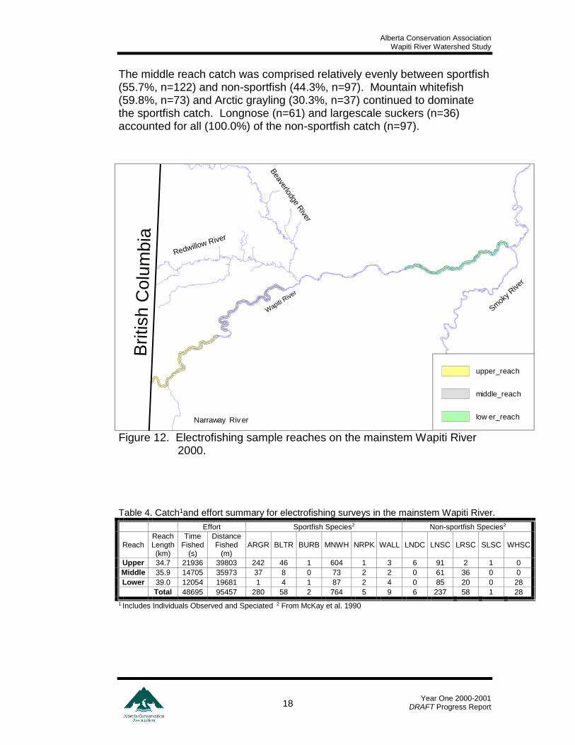
4.3.2 Wapiti River Sampling In total, 1448 fish, representing 11 species, were captured during Wapiti River mainstem electrofishing surveys (Table 4). Collectively, the 3 delineated reaches (Figure 12) received 48695 s and 95457 m of electrofishing effort (Table 4). The upper reach catch was dominated (90.0%, n=897) by sportfish. This sportfish catch was comprised mainly of mountain whitefish (67.3%, n=604), Arctic grayling (27.0%, n=242) and bull trout (5.1%, n=46). Longnose suckers accounted for 91.0% (n=91) of the non-sportfish catch.
Alberta Conservation Association Wapiti River Watershed Study
Year One 2000-2001
DRAFT Progress Report 18
The middle reach catch was comprised relatively evenly between sportfish (55.7%, n=122) and non-sportfish (44.3%, n=97). Mountain whitefish (59.8%, n=73) and Arctic grayling (30.3%, n=37) continued to dominate the sportfish catch. Longnose (n=61) and largescale suckers (n=36) accounted for all (100.0%) of the non-sportfish catch (n=97).
Figure 12. Electrofishing sample reaches on the mainstem Wapiti River 2000.
Table 4. Catch1and effort summary for electrofishing surveys in the mainstem Wapiti River.
Effort Sportfish Species2 Non-sportfish Species2
Reach Reach Length (km)
Time Fished
(s)
Distance Fished
(m) ARGR BLTR BURB MNWH NRPK WALL LNDC LNSC LRSC SLSC WHSC
Upper 34.7 21936 39803 242 46 1 604 1 3 6 91 2 1 0
Middle 35.9 14705 35973 37 8 0 73 2 2 0 61 36 0 0
Lower 39.0 12054 19681 1 4 1 87 2 4 0 85 20 0 28
Total 48695 95457 280 58 2 764 5 9 6 237 58 1 28
1 Includes Individuals Observed and Speciated 2 From McKay et al. 1990
Bri
tish C
olu
mbia
Beaverlodge R
iver
Redwillow River
Narraway Riv er
Wapiti
River
Smok
y River
low er_reach
middle_reach
upper_reach
Alberta Conservation Association Wapiti River Watershed Study
Year One 2000-2001
DRAFT Progress Report 19
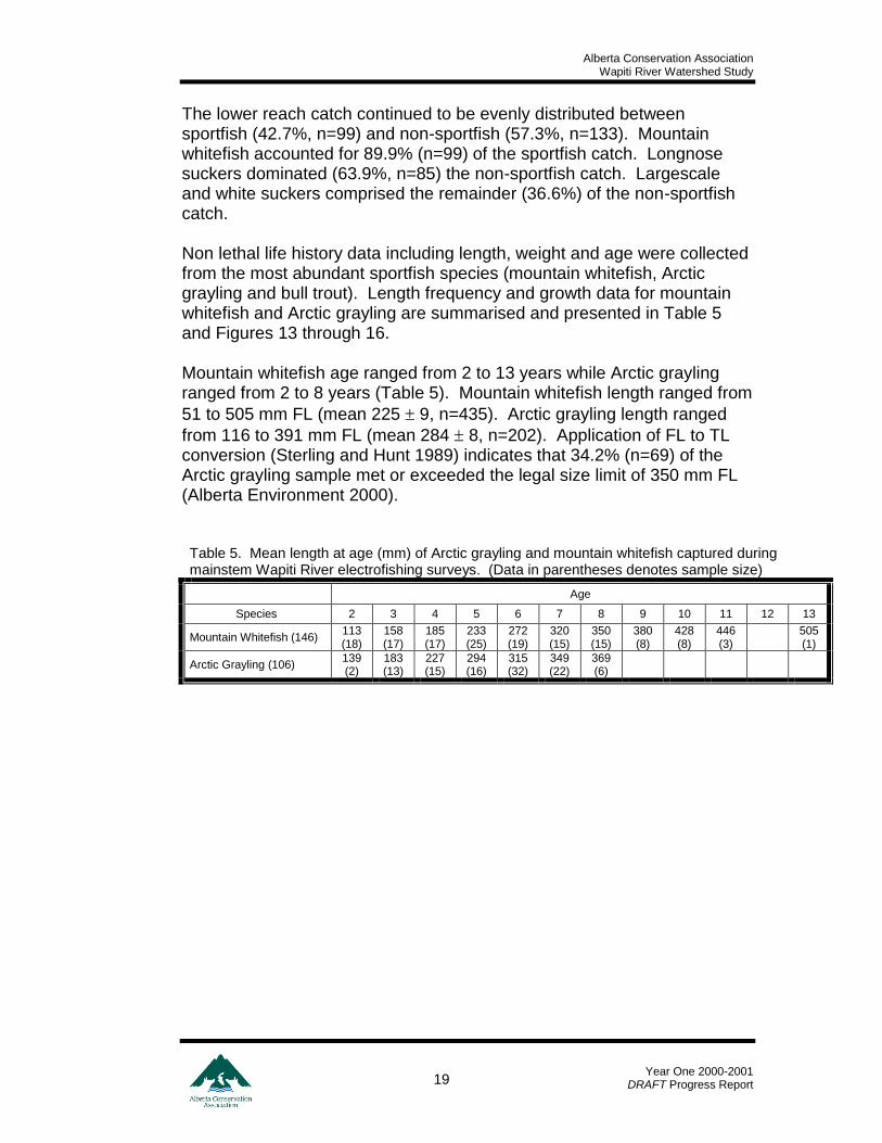
The lower reach catch continued to be evenly distributed between sportfish (42.7%, n=99) and non-sportfish (57.3%, n=133). Mountain whitefish accounted for 89.9% (n=99) of the sportfish catch. Longnose suckers dominated (63.9%, n=85) the non-sportfish catch. Largescale and white suckers comprised the remainder (36.6%) of the non-sportfish catch. Non lethal life history data including length, weight and age were collected from the most abundant sportfish species (mountain whitefish, Arctic grayling and bull trout). Length frequency and growth data for mountain whitefish and Arctic grayling are summarised and presented in Table 5 and Figures 13 through 16. Mountain whitefish age ranged from 2 to 13 years while Arctic grayling ranged from 2 to 8 years (Table 5). Mountain whitefish length ranged from
51 to 505 mm FL (mean 225 9, n=435). Arctic grayling length ranged
from 116 to 391 mm FL (mean 284 8, n=202). Application of FL to TL conversion (Sterling and Hunt 1989) indicates that 34.2% (n=69) of the Arctic grayling sample met or exceeded the legal size limit of 350 mm FL (Alberta Environment 2000). Table 5. Mean length at age (mm) of Arctic grayling and mountain whitefish captured during mainstem Wapiti River electrofishing surveys. (Data in parentheses denotes sample size)
Age
Species 2 3 4 5 6 7 8 9 10 11 12 13
Mountain Whitefish (146) 113 (18)
158 (17)
185 (17)
233 (25)
272 (19)
320 (15)
350 (15)
380 (8)
428 (8)
446 (3)
505 (1)
Arctic Grayling (106) 139 (2)
183 (13)
227 (15)
294 (16)
315 (32)
349 (22)
369 (6)
Alberta Conservation Association Wapiti River Watershed Study
Year One 2000-2001
DRAFT Progress Report 20
Figure 13. Length frequency distribution of mountain whitefish captured during mainstem Wapiti River electrofishing surveys 2000.
Figure 14. Length weight relationship of mountain whitefish captured during mainstem Wapiti River electrofishing surveys 2000.
Alberta Conservation Association Wapiti River Watershed Study
Year One 2000-2001
DRAFT Progress Report 21
Figure 15. Length frequency distribution of Arctic grayling captured during mainstem Wapiti River electrofishing surveys 2000
Figure 16. Length weight relationship of Arctic grayling captured during mainstem Wapiti River electrofishing surveys 2000.
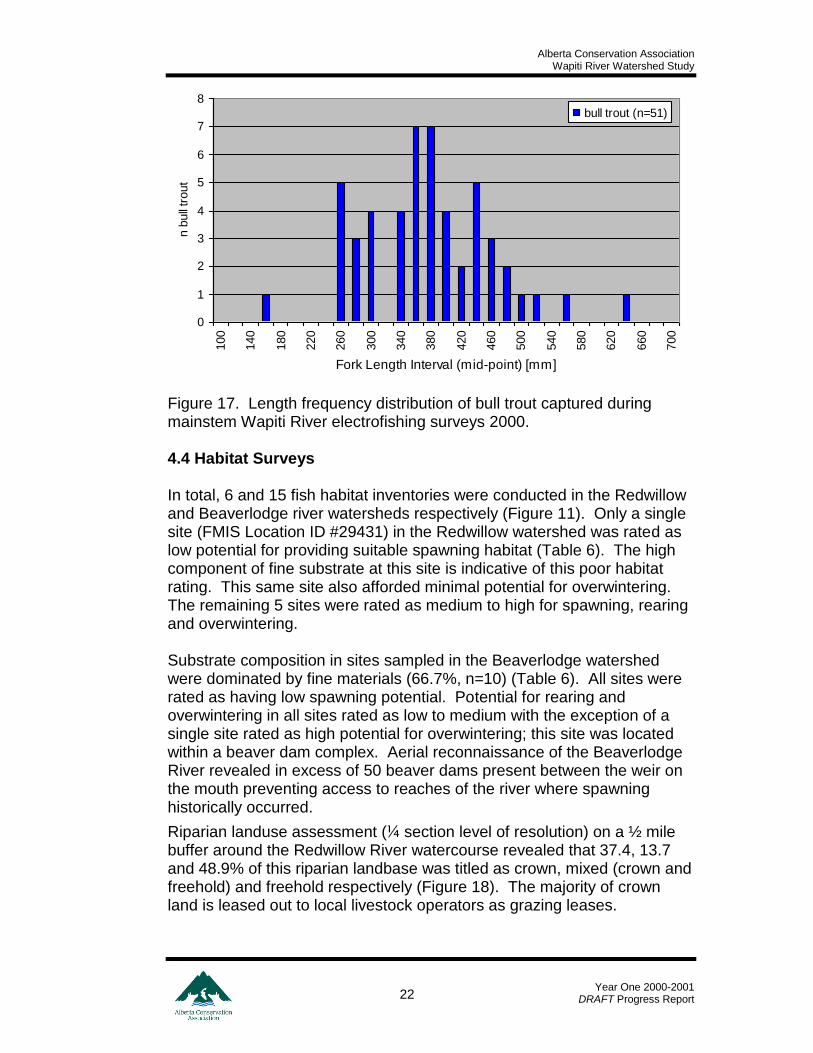
Bull trout ranged from 148 to 637 mm FL (mean 366.7 25.1, n=51) (Figure 17). Thirty-one percent (n=16) of the sample would be considered as adults (Hvenegaard and Fairless 1998).
Alberta Conservation Association Wapiti River Watershed Study
Year One 2000-2001
DRAFT Progress Report 22
Figure 17. Length frequency distribution of bull trout captured during mainstem Wapiti River electrofishing surveys 2000. 4.4 Habitat Surveys In total, 6 and 15 fish habitat inventories were conducted in the Redwillow and Beaverlodge river watersheds respectively (Figure 11). Only a single site (FMIS Location ID #29431) in the Redwillow watershed was rated as low potential for providing suitable spawning habitat (Table 6). The high component of fine substrate at this site is indicative of this poor habitat rating. This same site also afforded minimal potential for overwintering. The remaining 5 sites were rated as medium to high for spawning, rearing and overwintering. Substrate composition in sites sampled in the Beaverlodge watershed were dominated by fine materials (66.7%, n=10) (Table 6). All sites were rated as having low spawning potential. Potential for rearing and overwintering in all sites rated as low to medium with the exception of a single site rated as high potential for overwintering; this site was located within a beaver dam complex. Aerial reconnaissance of the Beaverlodge River revealed in excess of 50 beaver dams present between the weir on the mouth preventing access to reaches of the river where spawning historically occurred.
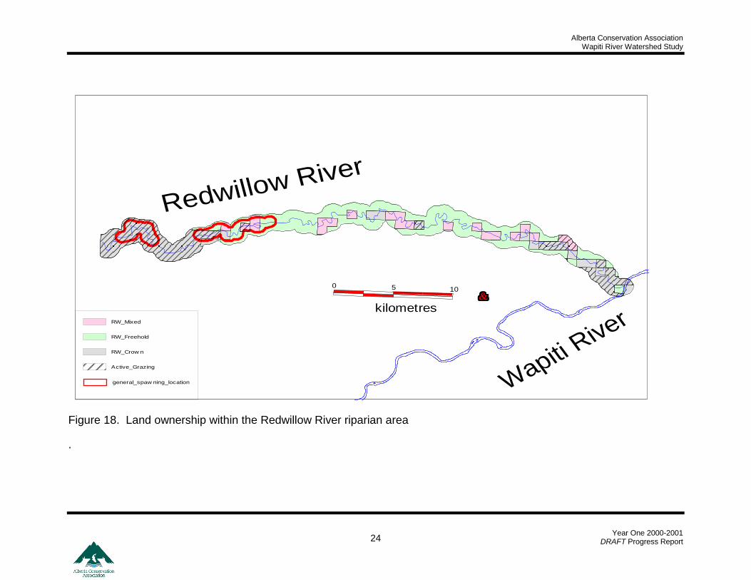
Riparian landuse assessment (¼ section level of resolution) on a ½ mile buffer around the Redwillow River watercourse revealed that 37.4, 13.7 and 48.9% of this riparian landbase was titled as crown, mixed (crown and freehold) and freehold respectively (Figure 18). The majority of crown land is leased out to local livestock operators as grazing leases.
0
1
2
3
4
5
6
7
8
100
140
180
220
260
300
340
380
420
460
500
540
580
620
660
700
Fork Length Interval (mid-point) [mm]
n b
ull
trout
bull trout (n=51)
Alberta Conservation Association Wapiti River Watershed Study
Year One 2000-2001
DRAFT Progress Report 23
Table 6. Habitat data on inventory sites in the Beaverlodge and Redwillow River watersheds May and June 2000.
Stream
Width (m) Substrate Composition (%) Bank Stability Habitat Rating
Sub-basin Waterbody Name Location ID Survey Date
Mean Depth
(m) Roote
d
Wett
ed
fin
es
sm
all
gra
vel
larg
e g
ravel
cobble
bould
er
bedro
ck
LU
B1
RU
B2
Water Temp (0C) S
paw
nin
g
Rearin
g
Overw
inte
rin
g
Beaverlodge Beaverlodge River 29429 4-May-00 0.4 22.6 8.9 11.7 8.3 11.3 49.7 19.0 0.0 3.5 1.3 10.5 L M M
Beaverlodge Windsor Creek 29432 11-May-00 0.2 5.4 4.1 100 0.0 0.0 0.0 0.0 0.0 1.5 1.7 9.5 L M L
Beaverlodge Beavertail Creek 29433 11-May-00 0.1 6.4 2.2 12.0 20.0 34.0 27.3 6.7 0.0 1.7 1.3 10.0 L M L
Beaverlodge Hume Creek 29449 11-May-00 0.3 5.4 4.1 95.6 2.2 2.2 0.0 0.0 0.0 1.0 1.0 9.5 L L L
Beaverlodge Windsor Creek 29450 11-May-00 1.0 5.0 5.0 100 0.0 0.0 0.0 0.0 0.0 1.0 1.0 10.0 L M L
Beaverlodge Graham Creek 29451 11-May-00 1.1 7.5 7.5 100 0.0 0.0 0.0 0.0 0.0 1.0 1.0 10.0 L M L
Beaverlodge Steeprock Creek 29435 31-May-00 0.1 8.4 3.1 29.7 30.0 29.3 10.3 0.7 0.0 2.7 3.0 10.0 L M L
Beaverlodge Steeprock Creek 29436 1-Jun-00 0.7 8.9 8.9 82.8 2.8 5.0 5.0 4.4 0.0 1.0 1.0 16.0 L L L
Beaverlodge Steeprock Creek 29437 1-Jun-00 0.3 14.9 11.3 76.1 7.8 6.1 7.8 2.2 0.0 1.0 2.3 14.0 L L L
Beaverlodge Beaverlodge River 29438 5-Jun-00 0.4 18.4 9.5 25.0 17.7 19.7 26.7 11.0 0.0 2.2 2.0 18.0 L M M
Beaverlodge Unnamed 29440 6-Jun-00 0.1 3.1 1.2 77.9 12.1 6.3 3.8 0.0 0.0 1.0 1.3 NA L L L
Beaverlodge Beavertail Creek 29441 6-Jun-00 0.3 7.9 6.6 24.6 21.3 25.0 22.5 6.7 0.0 1.0 1.0 18.0 L L L
Beaverlodge Beaverlodge River 29446 6-Jun-00 1.6 22.3 19.1 100 0.0 0.0 0.0 0.0 0.0 1.2 2.0 17.0 L M H
Beaverlodge Beaverlodge River 29453 6-Jun-00 0.6 17.9 15.2 57.3 10.3 12.3 14.3 5.3 0.0 1.0 1.5 20.0 L M M
Beaverlodge Beaverlodge River 29442 7-Jun-00 0.3 4.0 3.2 95.4 3.8 0.4 0.0 0.4 0.0 1.0 1.3 18.0 L L L
Redwillow Lattice Creek 29430 9-May-00 0.1 6.5 3.6 6.3 16.0 22.3 37.0 18.3 0.0 1.8 1.7 9.0 H H L
Redwillow Diamond Dick Creek 29431 9-May-00 0.5 10.1 5.3 54.7 13.3 12.0 14.0 6.0 0.0 2.7 2.7 9.5 L M L
Redwillow Redwillow River 29434 31-May-00 0.4 41.5 26.0 12.7 17.0 19.7 42.3 8.3 0.0 2.7 2.7 NA M H H
Redwillow Redwillow River 29443 8-Jun-00 0.5 31.2 20.4 10.0 15.0 15.0 35.0 25.0 0.0 1.7 1.2 14.5 M H H
Redwillow Redwillow River 29444 27-Jun-00 0.5 32.4 24.5 46.0 7.3 10.0 12.3 11.0 13.3 3.0 0.8 23.0 M H M
Redwillow Redwillow River 29445 28-Jun-00 0.4 46.6 29.5 5.0 11.7 28.7 37.3 14.0 3.3 2.2 1.7 20.0 M H H
1 Left Upstream Bank (the left bank when facing upstream)
2 Right Upstream Bank (the right bank when facing upstream)
Alberta Conservation Association Wapiti River Watershed Study
Year One 2000-2001
DRAFT Progress Report 24
Figure 18. Land ownership within the Redwillow River riparian area
.
Redwillow River
Wapiti
River
105
kilometres
0
general_spaw ning_location
Active_Grazing
RW_Crow n
RW_Freehold
RW_Mixed
Alberta Conservation Association Wapiti River Watershed Study
Year One 2000-2001
DRAFT Progress Report 25
5.0 DISCUSSION
5.1 Wapiti River The upper reach of the Wapiti River contains the highest abundance of sportfish throughout its length. It also provides overwintering habitat for bull trout and to some extent, Arctic grayling. The upper Narraway River (tributary to the upper reach of the Wapiti River) appears to be critical for spawning bull trout. Fish movements in the upper Wapiti River are obviously not confined to that portion within Alberta. Further movement monitoring studies are required to determine the degree of movement between Provinces. Arctic grayling spawning locations in the Wapiti River watershed were not determined (with the exception of the Redwillow River). The sample for radio transmittered Arctic grayling must be increased and more randomly deployed throughout the spatial plane of the Wapiti River mainstem. A mechanism to monitor movement into British Columbia must be considered. The general spawning location of bull trout was located in the upper reaches of the Narraway River. This area (s) must be ground-truthed and inventoried for young-of-the-year bull trout presence to confirm these data. In addition, the habitat of these spawning locations should be characterised. As with Arctic grayling, the sample size of radio transmittered bull trout should be increased and movement into British Columbia must be considered. 5.2 Redwillow River The Redwillow River Arctic grayling stock persists. The run commenced during late April and concluded near the end of May. Spawning occurs in the upper reaches of the river during mid May. Protection of this stock is imperative to maintain itself but also provide a source for natural re-colonisation of the Beaverlodge River system. To ensure this protection, confirmation of these spawning areas is required. This confirmation should consist of sampling during mid to late May to facilitate the capture of both adult and young-of-the-year Arctic grayling. In conjunction with this ground truthing exercise, an examination of habitat must be conducted to characterise preferred Arctic grayling habitat. These data will aid in determining specific habitats or anthropogenic landuse disturbances limiting fish production. This will permit the physical enhancement or remediation of degraded habitat.
Alberta Conservation Association Wapiti River Watershed Study
Year One 2000-2001
DRAFT Progress Report 26
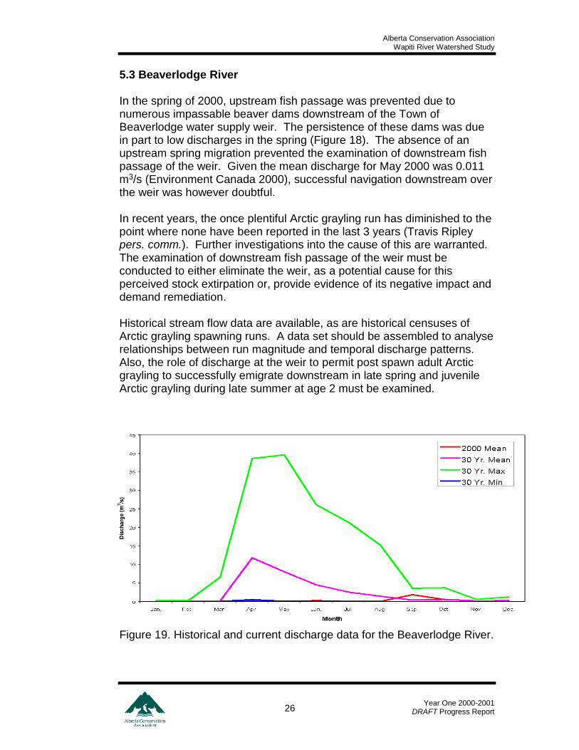
5.3 Beaverlodge River In the spring of 2000, upstream fish passage was prevented due to numerous impassable beaver dams downstream of the Town of Beaverlodge water supply weir. The persistence of these dams was due in part to low discharges in the spring (Figure 18). The absence of an upstream spring migration prevented the examination of downstream fish passage of the weir. Given the mean discharge for May 2000 was 0.011 m3/s (Environment Canada 2000), successful navigation downstream over the weir was however doubtful. In recent years, the once plentiful Arctic grayling run has diminished to the point where none have been reported in the last 3 years (Travis Ripley pers. comm.). Further investigations into the cause of this are warranted. The examination of downstream fish passage of the weir must be conducted to either eliminate the weir, as a potential cause for this perceived stock extirpation or, provide evidence of its negative impact and demand remediation. Historical stream flow data are available, as are historical censuses of Arctic grayling spawning runs. A data set should be assembled to analyse relationships between run magnitude and temporal discharge patterns. Also, the role of discharge at the weir to permit post spawn adult Arctic grayling to successfully emigrate downstream in late spring and juvenile Arctic grayling during late summer at age 2 must be examined.
Figure 19. Historical and current discharge data for the Beaverlodge River.
Alberta Conservation Association Wapiti River Watershed Study
Year One 2000-2001
DRAFT Progress Report 27
6.0 LITERATURE CITED
Alberta Environment, 1998. A Fish conservation Strategy for Alberta.
Pub. No. I/698, ISBN: 0-1185-0148-5
Alberta Environment, 2000. Alberta Guide to Sportfishing Regulations Baxter, J.S. 1995. Chowade River bull trout studies 1995: habitat and
population assessment. Department of Zoology, University of British Columbia, Vancouver, British Columbia. 30 pp. + APP.
Bidgood, B. 1980. Field surgical procedure for implantation of radio tags in
fish. Alberta Fish and Wildlife Division. Fisheries Research Report No. 20. Edmonton, Alberta. 9 pp.
Carl, L., D. Walty and D.M. Rimmer. 1992. Demography of spawning grayling (Thymallus arcticus) in the Beaverlodge River, Alberta. Hydrobiologia. 243/244: 237-247. Belgium.
Chambers, P.A. and T. Mill. 1996. Northern River Basin Study Synthesis Report No. 5, Dissolved oxygen conditions and fish requirements in the Peace, Athabasca and Slave Rivers: assessment of present conditions and future trends. Northern River Basin Study, Edmonton, Alberta.
Environment Canada. 2000. Hydat CD-ROM Ver. 3.0. Surface Water Data Environment Canada. Water Resources Branch, Ottawa.
Fraikin, C.G.J., D.A. Steel, C. Briggs and Z.E. Kovats. 1998. Environmental Effects Monitoring Cycle 2. Report prepared for Weyerhaeuser Canada Ltd., Grande Prairie, AB, by Golder Associates Ltd., Calgary, AB.
Hvenegaard, P.J. and D. Fairless. 1998. Biology and Status of Bull Trout (Salvelinus confluentus) in the Kakwa River Drainage, Alberta. Alberta Conservation Association, Peace River, AB. 26 pp. + App.
Hvenegaard, P.J. 1998. Cooperative fisheries inventory program. Final Report. Tech. Rep. Prep. for the Dept. of Fisheries and Oceans, Canadian Forest Products Ltd., Weyerhaeuser Can. Ltd., Daishowa Marubeni International, Manning Diversified Forest Products Ltd. and Ainsworth Lumber Co. by Alberta Conservation Association, Peace River, AB. 22 pp. + App
Alberta Conservation Association Wapiti River Watershed Study
Year One 2000-2001
DRAFT Progress Report 28
Hvenegaard, P.J. and T.D. Boag. 1993. A spawning survey of rainbow trout in Jumpingpound Creek. Prep. for Trout Unlimited Canada by D.A. Westworth and Associates. 19 pp. + App
Kristofferson, W.C., D.K. McGowan, and W.J. Ward. 1986. Fish weirs for the commercial harvest of searun Arctic charr. Can. Ind. Rep. Aquat. Sci. 174. 31 pp.
Lucko, B. 1995. Assessment of the Beaverlodge and Redwillow Rivers Spawning Run Spring, 1994. Peace River, Alberta: Alberta Environmental Protection, Natural Resources Service.
Mackay, W.C., G.R. Ash, and H.J. Norris. 1990. Fish ageing methods for Alberta. Prep. by R.L.&L. Environmental Services Ltd. in assoc. with Alberta Fish and Wild. Div. and Univ. of Alberta, Edmonton. 113 pp.
McKinley, R.S., G. Power, and H.E. Kowalyk. 1992. Transmitter attachment/implant – labrortory manual. Ontario Hydro Research and University of Waterloo, Biology Department.
Schroeder, Don. 1992. A summary of Fish Captured at the Beaverlodge River Weir during the Spring of 1992.
Schwanke, Thomas; Clermont, Tim, and Schroeder, D. G. 1983. Assessment of Beaverlodge Fishway During the 1983 Spring Spawning Migrations.
Sterling, G. L. and C. Hunt. 1989. Preliminary survey of Arctic grayling movements, age and growth in the Little Smoky River, Alberta, 1987-88. Alberta Forestry, Lands and Wildlife, Fish and Wildlife Division. 299 pp.
Swanson, S. M. 1993. Wapiti/Smoky River Ecosystem Study. Sentar Consultants Ltd.
Alberta Conservation Association Wapiti River Watershed Study
Year One 2000-2001
DRAFT Progress Report 29
7.0 APPENDICES
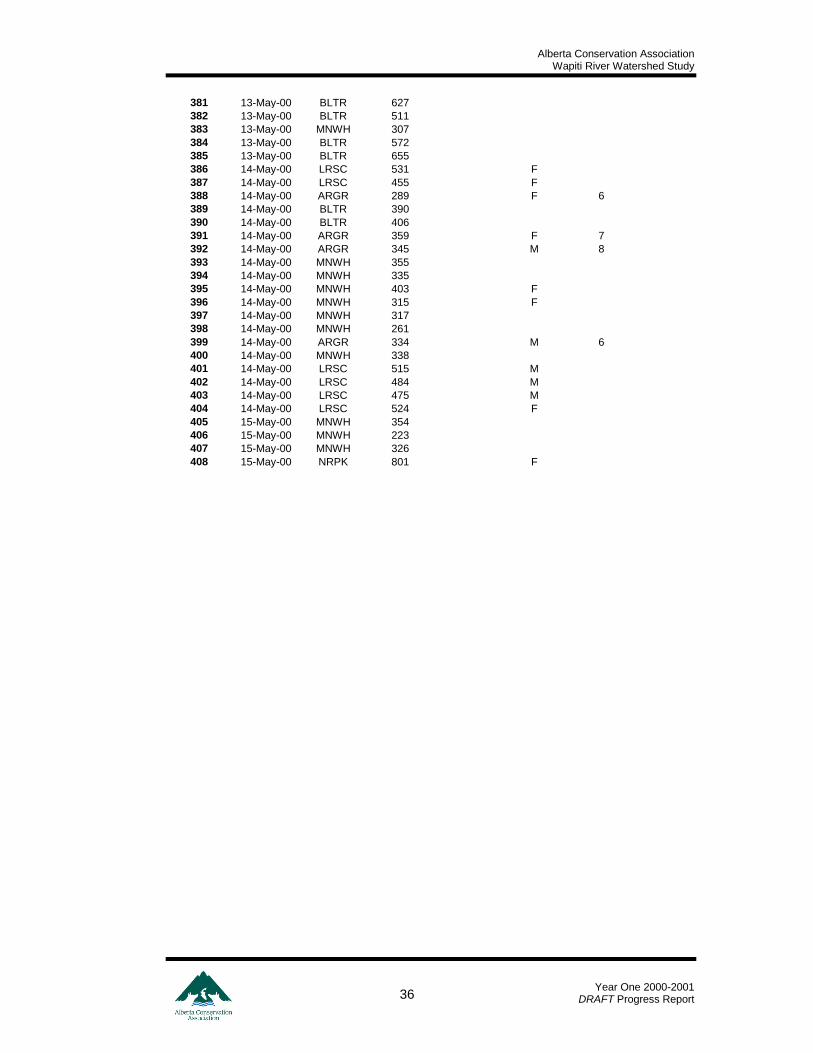
Appendix A: Redwillow Trap Daily Catch Records Activity Date ARGR BLTR BURB LNSC LRSC MNWH NRPK WALL WHSC SUM
21-Apr-00 0 0 0 0 0 3 0 0 0 3
22-Apr-00 0 0 0 0 0 3 0 0 0 3
23-Apr-00 0 0 0 0 0 0 0 0 0 0
24-Apr-00 0 0 0 0 0 5 0 0 0 5
25-Apr-00 0 1 0 0 0 1 2 0 0 4
26-Apr-00 2 0 0 0 0 5 0 0 0 7
27-Apr-00 3 1 0 1 0 2 0 0 0 7
28-Apr-00 0 0 0 1 0 0 1 0 0 2
29-Apr-00 6 0 0 2 0 1 0 0 3 12
30-Apr-00 5 0 0 3 0 1 0 0 0 9
1-May-00 13 2 0 13 0 1 0 0 0 29
2-May-00 28 3 0 8 0 2 2 0 2 45
3-May-00 34 5 0 0 0 2 1 0 0 42
4-May-00 52 8 0 28 0 15 2 0 2 107
5-May-00 22 1 0 0 0 4 2 1 0 30
6-May-00 17 3 0 19 13 2 1 2 0 57
7-May-00 11 2 0 44 0 2 3 0 6 68
8-May-00 5 0 0 19 0 1 4 0 13 42
9-May-00 5 0 0 24 14 2 1 0 0 46
10-May-00 0 1 0 0 9 0 0 0 1 11
11-May-00 1 0 0 0 2 1 0 0 0 4
12-May-00 4 1 0 0 3 0 1 0 0 9
13-May-00 5 4 1 8 10 2 0 0 0 30
14-May-00 4 2 0 0 6 7 0 0 0 19
15-May-00 0 0 0 0 0 3 1 0 0 4
SUM 217 34 1 170 57 65 21 3 27 595
Alberta Conservation Association Wapiti River Watershed Study
Year One 2000-2001
DRAFT Progress Report 30
Appendix B: Redwillow River Fish Trap Fish Measurement Data
No. Date AEP Code Fork Length Weight Sex Age
1 21-Apr-00 MNWH 232
2 21-Apr-00 MNWH 334
3 21-Apr-00 MNWH 263
4 22-Apr-00 MNWH 305
5 22-Apr-00 MNWH 356
6 24-Apr-00 MNWH 294
7 24-Apr-00 MNWH 303
8 24-Apr-00 MNWH 332
9 24-Apr-00 MNWH 306
10 24-Apr-00 MNWH 256
11 25-Apr-00 NRPK 448
12 25-Apr-00 MNWH 316
13 25-Apr-00 NRPK 462
14 25-Apr-00 BLTR 525
15 26-Apr-00 ARGR 400 U 9
16 26-Apr-00 MNWH 302
17 26-Apr-00 MNWH 358
18 26-Apr-00 MNWH 336
19 26-Apr-00 ARGR 393 U 8
20 26-Apr-00 MNWH 337
21 26-Apr-00 MNWH 346
22 27-Apr-00 ARGR 361 U 8
23 27-Apr-00 ARGR 385 M 9
24 27-Apr-00 MNWH 401
25 27-Apr-00 LNSC 442
26 27-Apr-00 BLTR 563
27 27-Apr-00 ARGR 363 M 6
28 27-Apr-00 MNWH 334
29 28-Apr-00 LNSC 375
30 28-Apr-00 NRPK 561
31 29-Apr-00 ARGR 308 U 5
32 29-Apr-00 MNWH 312
33 29-Apr-00 LNSC 448
34 29-Apr-00 WHSC 498
35 29-Apr-00 WHSC 543
36 29-Apr-00 ARGR 367 U 8
37 29-Apr-00 ARGR 338 U 6
38 29-Apr-00 ARGR 337 U 7
39 29-Apr-00 ARGR 347 U 7
40 29-Apr-00 ARGR 383 U 8
41 29-Apr-00 LNSC 420
42 29-Apr-00 WHSC 530
43 30-Apr-00 LNSC 367
44 30-Apr-00 ARGR 366 U 6
45 30-Apr-00 ARGR 316 U 6
46 30-Apr-00 ARGR 338 U
47 30-Apr-00 LNSC 410
48 30-Apr-00 LNSC 353
49 30-Apr-00 ARGR 315 U 6
50 30-Apr-00 ARGR 313 U 6
51 30-Apr-00 MNWH 404
52 1-May-00 LNSC 403
53 1-May-00 LNSC 381
54 1-May-00 LNSC 351
55 1-May-00 LNSC 385
56 1-May-00 ARGR 358 U 8
57 1-May-00 ARGR 349 U 8
58 1-May-00 ARGR 399 U 9
59 1-May-00 LNSC 444
60 1-May-00 LNSC 419
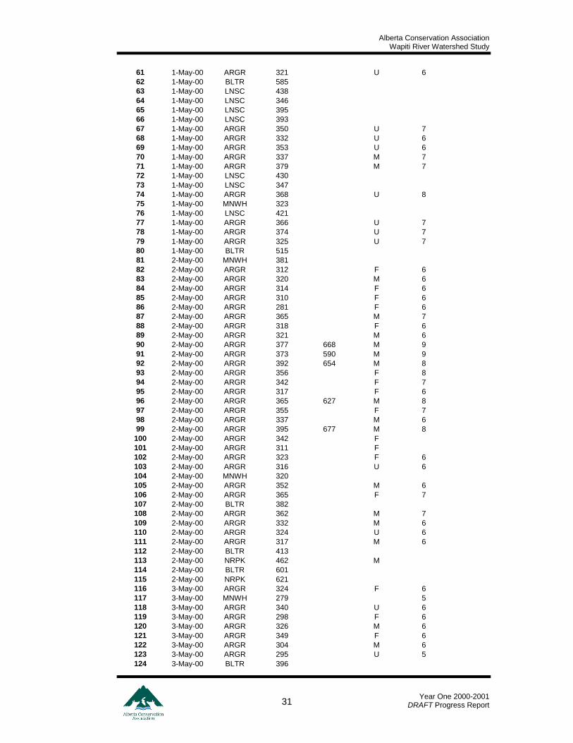
Alberta Conservation Association Wapiti River Watershed Study
Year One 2000-2001
DRAFT Progress Report 31
61 1-May-00 ARGR 321 U 6
62 1-May-00 BLTR 585
63 1-May-00 LNSC 438
64 1-May-00 LNSC 346
65 1-May-00 LNSC 395
66 1-May-00 LNSC 393
67 1-May-00 ARGR 350 U 7
68 1-May-00 ARGR 332 U 6
69 1-May-00 ARGR 353 U 6
70 1-May-00 ARGR 337 M 7
71 1-May-00 ARGR 379 M 7
72 1-May-00 LNSC 430
73 1-May-00 LNSC 347
74 1-May-00 ARGR 368 U 8
75 1-May-00 MNWH 323
76 1-May-00 LNSC 421
77 1-May-00 ARGR 366 U 7
78 1-May-00 ARGR 374 U 7
79 1-May-00 ARGR 325 U 7
80 1-May-00 BLTR 515
81 2-May-00 MNWH 381
82 2-May-00 ARGR 312 F 6
83 2-May-00 ARGR 320 M 6
84 2-May-00 ARGR 314 F 6
85 2-May-00 ARGR 310 F 6
86 2-May-00 ARGR 281 F 6
87 2-May-00 ARGR 365 M 7
88 2-May-00 ARGR 318 F 6
89 2-May-00 ARGR 321 M 6
90 2-May-00 ARGR 377 668 M 9
91 2-May-00 ARGR 373 590 M 9
92 2-May-00 ARGR 392 654 M 8
93 2-May-00 ARGR 356 F 8
94 2-May-00 ARGR 342 F 7
95 2-May-00 ARGR 317 F 6
96 2-May-00 ARGR 365 627 M 8
97 2-May-00 ARGR 355 F 7
98 2-May-00 ARGR 337 M 6
99 2-May-00 ARGR 395 677 M 8
100 2-May-00 ARGR 342 F
101 2-May-00 ARGR 311 F
102 2-May-00 ARGR 323 F 6
103 2-May-00 ARGR 316 U 6
104 2-May-00 MNWH 320
105 2-May-00 ARGR 352 M 6
106 2-May-00 ARGR 365 F 7
107 2-May-00 BLTR 382
108 2-May-00 ARGR 362 M 7
109 2-May-00 ARGR 332 M 6
110 2-May-00 ARGR 324 U 6
111 2-May-00 ARGR 317 M 6
112 2-May-00 BLTR 413
113 2-May-00 NRPK 462 M
114 2-May-00 BLTR 601
115 2-May-00 NRPK 621
116 3-May-00 ARGR 324 F 6
117 3-May-00 MNWH 279 5
118 3-May-00 ARGR 340 U 6
119 3-May-00 ARGR 298 F 6
120 3-May-00 ARGR 326 M 6
121 3-May-00 ARGR 349 F 6
122 3-May-00 ARGR 304 M 6
123 3-May-00 ARGR 295 U 5
124 3-May-00 BLTR 396
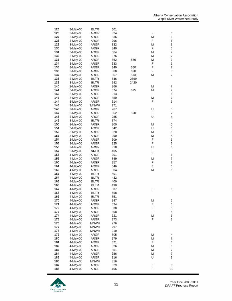
Alberta Conservation Association Wapiti River Watershed Study
Year One 2000-2001
DRAFT Progress Report 32
125 3-May-00 BLTR 501
126 3-May-00 ARGR 324 F 6
127 3-May-00 ARGR 336 M 6
128 3-May-00 ARGR 296 F 5
129 3-May-00 ARGR 332 M 6
130 3-May-00 ARGR 340 F 6
131 3-May-00 ARGR 364 M 7
132 3-May-00 ARGR 376 M 7
133 3-May-00 ARGR 362 536 M 7
134 3-May-00 ARGR 333 F 6
135 3-May-00 ARGR 349 560 F 7
136 3-May-00 ARGR 368 620 F 8
137 3-May-00 ARGR 367 573 M 7
138 3-May-00 BLTR 646 2669
139 3-May-00 BLTR 642 2420
140 3-May-00 ARGR 366 M 7
141 3-May-00 ARGR 374 625 M 7
142 3-May-00 ARGR 313 F 6
143 3-May-00 ARGR 350 M 7
144 3-May-00 ARGR 314 F 6
145 3-May-00 MNWH 271
146 3-May-00 ARGR 267 U 5
147 3-May-00 ARGR 362 590 F 7
148 3-May-00 ARGR 285 U 4
149 3-May-00 BLTR 374
150 3-May-00 ARGR 300 M 5
151 3-May-00 ARGR 342 U 6
152 3-May-00 ARGR 320 M 6
153 3-May-00 ARGR 290 M 4
154 3-May-00 ARGR 309 F 6
155 3-May-00 ARGR 325 F 6
156 3-May-00 ARGR 318 U 6
157 3-May-00 NRPK 405 F
158 4-May-00 ARGR 301 F 6
159 4-May-00 ARGR 349 M 7
160 4-May-00 ARGR 357 F 7
161 4-May-00 ARGR 346 F 6
162 4-May-00 ARGR 304 M 6
163 4-May-00 BLTR 401
164 4-May-00 BLTR 432
165 4-May-00 BLTR 400
166 4-May-00 BLTR 490
167 4-May-00 ARGR 307 F 6
168 4-May-00 BLTR 558
169 4-May-00 BLTR 551
170 4-May-00 ARGR 347 M 6
171 4-May-00 ARGR 334 F 6
172 4-May-00 ARGR 338 F 5
173 4-May-00 ARGR 308 F 5
174 4-May-00 ARGR 321 M 6
175 4-May-00 ARGR 273 F 5
176 4-May-00 MNWH 276
177 4-May-00 MNWH 297
178 4-May-00 MNWH 310
179 4-May-00 ARGR 305 M 4
180 4-May-00 ARGR 379 M 7
181 4-May-00 ARGR 371 F 6
182 4-May-00 ARGR 326 M 6
183 4-May-00 ARGR 351 M 7
184 4-May-00 ARGR 386 M 7
185 4-May-00 ARGR 316 U 5
186 4-May-00 MNWH 316
187 4-May-00 ARGR 329 F 6
188 4-May-00 ARGR 406 F 10
Alberta Conservation Association Wapiti River Watershed Study
Year One 2000-2001
DRAFT Progress Report 33
189 4-May-00 MNWH 313
190 4-May-00 MNWH 299
191 4-May-00 ARGR 371 U 7
192 4-May-00 ARGR 291 U 5
193 4-May-00 ARGR 312 F 6
194 4-May-00 ARGR 314 M 6
195 4-May-00 ARGR 345 U 6
196 4-May-00 ARGR 321 U 6
197 4-May-00 MNWH 297
198 4-May-00 ARGR 307 M 5
199 4-May-00 ARGR 303 F 5
200 4-May-00 ARGR 274 F 4
201 4-May-00 ARGR 339 F 6
202 4-May-00 ARGR 330 M 6
203 4-May-00 BLTR 645 2202
204 4-May-00 ARGR 295 F 6
205 4-May-00 ARGR 319 M 6
206 4-May-00 ARGR 305 M 5
207 4-May-00 ARGR 359 M 6
208 4-May-00 ARGR 298 M 4
209 4-May-00 ARGR 337 M 6
210 4-May-00 ARGR 350 M 6
211 4-May-00 ARGR 346 M 6
212 4-May-00 ARGR 361 F 7
213 4-May-00 ARGR 376 595 M 7
214 4-May-00 ARGR 321 M 6
215 4-May-00 ARGR 349 F 6
216 4-May-00 ARGR 378 575 M 7
217 4-May-00 ARGR 371 544 M 7
218 4-May-00 MNWH 285
219 4-May-00 ARGR 308 F 6
220 4-May-00 MNWH 287
221 4-May-00 MNWH 300
222 4-May-00 ARGR 310 F 6
223 4-May-00 MNWH 331
224 4-May-00 ARGR 283 F 5
225 4-May-00 ARGR 304 U 5
226 4-May-00 ARGR 299 M 6
227 4-May-00 NRPK 529 F
228 4-May-00 ARGR 323 M 6
229 4-May-00 MNWH 290
230 4-May-00 MNWH 349
231 4-May-00 BLTR 266
232 4-May-00 MNWH 274
233 4-May-00 NRPK 437 M
234 4-May-00 MNWH 275
235 5-May-00 ARGR 281 M 5
236 5-May-00 ARGR 326 M 6
237 5-May-00 MNWH 270
238 5-May-00 ARGR 306 F 6
239 5-May-00 ARGR 354 F 8
240 5-May-00 ARGR 336 U 7
241 5-May-00 ARGR 288 F 5
242 5-May-00 BLTR 612
243 5-May-00 ARGR 300 M 5
244 5-May-00 WALL 520 M
245 5-May-00 ARGR 343 M 7
246 5-May-00 ARGR 307 F 6
247 5-May-00 MNWH 304
248 5-May-00 MNWH 270
249 5-May-00 ARGR 301 F 6
250 5-May-00 ARGR 299 F 5
251 5-May-00 ARGR 327 M 6
252 5-May-00 ARGR 315 M 6
Alberta Conservation Association Wapiti River Watershed Study
Year One 2000-2001
DRAFT Progress Report 34
253 5-May-00 ARGR 296 M 6
254 5-May-00 ARGR 301 F 5
255 5-May-00 ARGR 328 F 6
256 5-May-00 MNWH 298
257 5-May-00 ARGR 302 M 6
258 5-May-00 ARGR 296 F 4
259 5-May-00 ARGR 315 F 5
260 5-May-00 ARGR 314 F 6
261 5-May-00 ARGR 305 M 5
262 5-May-00 ARGR 302 U 5
263 5-May-00 NRPK 427 M
264 5-May-00 NRPK 419 M
265 6-May-00 ARGR 311 F 6
266 6-May-00 ARGR 326 F 6
267 6-May-00 ARGR 333 F 7
268 6-May-00 ARGR 318 M 5
269 6-May-00 BLTR 396
270 6-May-00 MNWH 315
271 6-May-00 MNWH 309
272 6-May-00 ARGR 353 M 7
273 6-May-00 ARGR 278 F 6
274 6-May-00 ARGR 344 M 6
275 6-May-00 ARGR 331 F 7
276 6-May-00 ARGR 347 F 7
277 6-May-00 ARGR 328 F 7
278 6-May-00 ARGR 345 M 7
279 6-May-00 ARGR 297 F 5
280 6-May-00 ARGR 309 F 6
281 6-May-00 ARGR 351 M 7
282 6-May-00 ARGR 315 F 6
283 6-May-00 ARGR 316 M 7
284 6-May-00 ARGR 319 M 6
285 6-May-00 BLTR 615
286 6-May-00 BLTR 440
287 6-May-00 WALL 416 F
288 6-May-00 WALL 485 M
289 6-May-00 NRPK 483 F
290 7-May-00 ARGR 330 M 7
291 7-May-00 ARGR 274 F 4
292 7-May-00 MNWH 503
293 7-May-00 BLTR 364
294 7-May-00 ARGR 326 M 6
295 7-May-00 ARGR 320 M 6
296 7-May-00 ARGR 303 M 5
297 7-May-00 ARGR 333 M 6
298 7-May-00 ARGR 293 F 6
299 7-May-00 ARGR 358 M 7
300 7-May-00 ARGR 295 M 5
301 7-May-00 ARGR 303 F 5
302 7-May-00 ARGR 343 M 6
303 7-May-00 NRPK 453 M
304 7-May-00 NRPK 450 M
305 7-May-00 BLTR 456
306 7-May-00 MNWH 380
307 7-May-00 NRPK 686 F
308 8-May-00 ARGR 285 F 5
309 8-May-00 ARGR 305 F 5
310 8-May-00 NRPK 443 M
311 8-May-00 NRPK 465 M
312 8-May-00 ARGR 338 F 6
313 8-May-00 ARGR 287 F 5
314 8-May-00 MNWH 340
315 8-May-00 ARGR 285 F 5
316 8-May-00 NRPK 453 M
Alberta Conservation Association Wapiti River Watershed Study
Year One 2000-2001
DRAFT Progress Report 35
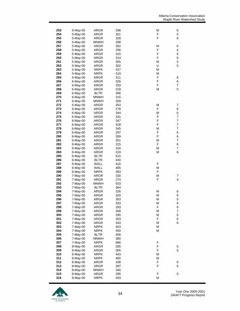
317 8-May-00 NRPK 455 M
318 9-May-00 ARGR 339 M 7
319 9-May-00 ARGR 334 F 7
320 9-May-00 ARGR 327 U 7
321 9-May-00 MNWH 304
322 9-May-00 ARGR 342 M 6
323 9-May-00 MNWH 277
324 9-May-00 ARGR 331 F 6
325 9-May-00 LRSC 550 U
326 9-May-00 LRSC 531 F
327 9-May-00 LRSC 511 U
328 9-May-00 LRSC 449 F
329 9-May-00 LRSC 486 F
330 9-May-00 LRSC 524 M
331 9-May-00 LRSC 540 F
332 9-May-00 LRSC 460 M
333 9-May-00 NRPK 410 M
334 9-May-00 LRSC 515 U
335 9-May-00 LRSC 500 U
336 9-May-00 LRSC 490 F
337 9-May-00 LRSC 476 F
338 9-May-00 LRSC 526 F
339 9-May-00 LRSC 511 U
340 10-May-00 BLTR 444
341 10-May-00 LRSC 526 F
342 10-May-00 LRSC 539 F
343 10-May-00 LRSC 545 F
344 10-May-00 LRSC 505 M
345 10-May-00 LRSC 487 M
346 10-May-00 LRSC 485 M
347 10-May-00 LRSC 516 F
348 10-May-00 LRSC 570 F
349 10-May-00 WHSC 416 M
350 10-May-00 LRSC 553 F
351 11-May-00 MNWH 309
352 11-May-00 LRSC 541 U
353 11-May-00 LRSC 537 U
354 11-May-00 ARGR 271 U 4
355 12-May-00 LRSC 467 M
356 12-May-00 ARGR 323 F 6
357 12-May-00 ARGR 327 F 6
358 12-May-00 ARGR 386 M 7
359 12-May-00 BLTR 571
360 12-May-00 NRPK 687 F
361 12-May-00 ARGR 300 F 6
362 12-May-00 LRSC 546 U
363 12-May-00 LRSC 540 U
364 13-May-00 ARGR 290 M 5
365 13-May-00 ARGR 351 F 7
366 13-May-00 ARGR 321 M 7
367 13-May-00 BURB 609
368 13-May-00 ARGR 341 F 7
369 13-May-00 LRSC 485 F
370 13-May-00 LRSC 456 F
371 13-May-00 LRSC 500 F
372 13-May-00 LRSC 411 M
373 13-May-00 LRSC 421 M
374 13-May-00 ARGR 301 F 5
375 13-May-00 LRSC 435 M
376 13-May-00 LRSC 475 M
377 13-May-00 LRSC 475 M
378 13-May-00 LRSC 467 M
379 13-May-00 LRSC 403 F
380 13-May-00 MNWH 369
Alberta Conservation Association Wapiti River Watershed Study
Year One 2000-2001
DRAFT Progress Report 36
381 13-May-00 BLTR 627
382 13-May-00 BLTR 511
383 13-May-00 MNWH 307
384 13-May-00 BLTR 572
385 13-May-00 BLTR 655
386 14-May-00 LRSC 531 F
387 14-May-00 LRSC 455 F
388 14-May-00 ARGR 289 F 6
389 14-May-00 BLTR 390
390 14-May-00 BLTR 406
391 14-May-00 ARGR 359 F 7
392 14-May-00 ARGR 345 M 8
393 14-May-00 MNWH 355
394 14-May-00 MNWH 335
395 14-May-00 MNWH 403 F
396 14-May-00 MNWH 315 F
397 14-May-00 MNWH 317
398 14-May-00 MNWH 261
399 14-May-00 ARGR 334 M 6
400 14-May-00 MNWH 338
401 14-May-00 LRSC 515 M
402 14-May-00 LRSC 484 M
403 14-May-00 LRSC 475 M
404 14-May-00 LRSC 524 F
405 15-May-00 MNWH 354
406 15-May-00 MNWH 223
407 15-May-00 MNWH 326
408 15-May-00 NRPK 801 F
Alberta Conservation Association Wapiti River Watershed Study
Year One 2000-2001
DRAFT Progress Report 37
Appendix C: Radio Transmittered Fish Data
Mark Date AEP
Code Length
mm Weight
g External
Tag Color External Tag No.
Radio Frequency
Location River km
Maturity Sex Initial
Capture
2-May-00 ARGR 377 668 G 10399 149.018 RR Trap 5.696 Mature Ripe M Y
2-May-00 ARGR 373 590 G 10400 149.124 RR Trap 5.696 Mature Ripe M Y
2-May-00 ARGR 392 654 G 10393 149.601 RR Trap 5.696 Mature Ripe M Y
2-May-00 ARGR 365 627 G 10403 149.079 RR Trap 5.696 Mature Ripe M Y
2-May-00 ARGR 395 677 G 10407 149.031 RR Trap 5.696 Mature Ripe M Y
3-May-00 ARGR 362 536 G 10450 149.067 RR Trap 5.696 Mature Ripe M Y
3-May-00 ARGR 374 625 G 10454 149.091 RR Trap 5.696 Mature Ripe M Y
3-May-00 ARGR 362 590 G 10459 149.007 RR Trap 5.696 Mature Ripe F Y
3-May-00 ARGR 349 560 G 10430 149.561 RR Trap 5.696 Mature Ripe F Y
3-May-00 ARGR 368 620 G 10432 149.041 RR Trap 5.696 Mature Ripe F Y
3-May-00 ARGR 367 573 G 10442 149.551 RR Trap 5.696 Mature Ripe M Y
3-May-00 BLTR 646 2669 G 10451 149.735 RR Trap 5.696 Y
3-May-00 BLTR 642 2420 G 10452 149.637 RR Trap 5.696 Y
4-May-00 ARGR 376 595 G 10490 149.112 RR Trap 5.696 Mature Ripe M Y
4-May-00 ARGR 378 575 G 10479 149.136 RR Trap 5.696 Mature Ripe M Y
4-May-00 ARGR 371 544 G 10482 149.149 RR Trap 5.696 Mature Ripe M Y
4-May-00 BLTR 645 2202 G 10504 149.677 RR Trap 5.696 Y
12-May-00 ARGR 386 G 10636 149.055 RR Trap 5.696 Mature Ripe M Y
12-May-00 BLTR 571 G 10637 149.857 RR Trap 5.696 Y
9-Aug-00 ARGR 366 G 10857 149.388 Wapiti R. 161.511 Y
9-Aug-00 ARGR 370 635 G 10856 149.46 Wapiti R. 161.511 Y
9-Aug-00 BLTR 553 G 10858 149.292 Wapiti R. 161.511 Y
9-Aug-00 BLTR 429 G 10879 149.577 Wapiti R. 156.318 Y
10-Aug-00 ARGR 370 G 10904 149.352 Wapiti R. 152.308 Y
10-Aug-00 ARGR 384 G 10905 149.34 Wapiti R. 152.308 Y
10-Aug-00 BLTR 513 G 10888 149.521 Wapiti R. 153.685 Y
10-Aug-00 BLTR 637 G 10889 149.16 Wapiti R. 153.685 Y
10-Aug-00 BLTR 475 G 10906 149.281 Wapiti R. 152.308 Y
10-Aug-00 BLTR 459 G 10907 149.657 Wapiti R. 152.308 Y
10-Aug-00 BLTR 458 G 10928 149.196 Wapiti R. 150.242 Y
12-Oct-00 BLTR 495 1150 G 12203 149.221 Wapiti R. 27.375 Y
12-Oct-00 BLTR 476 G 12204 149.316 Wapiti R. 27.375 Y