Embed Size (px)
Citation preview

1
Grayling Society
Advisory Visit
Afon Cain, Powys
January, 2011

2
1.0 Introduction
This report is the output of a site visit undertaken by Tim Jacklin of the Wild Trout Trust to the Afon Cain, Powys, on 28th January, 2011. Comments in this report are based on observations on the day of the site visit and discussions with Tony Bostock of the Severn Rivers Trust (SRT) and Richard Dearing, Catchment Officer with the Environment Agency (EA).
Normal convention is applied throughout the report with respect to bank identification, i.e. the banks are designated left hand bank (LHB) or right hand bank (RHB) whilst looking downstream.
2.0 Catchment / Fishery Overview
The confluence of the Nant Fyllon and Nant Alan about 2 km to the west of Llanfyllin forms the Afon Cain. The Cain flows eastwards for approximately 11 km through Llanfyllin and Llanfechain before joining the River Vyrnwy at Llansantffraid; the confluence with the Vyrnwy is a short distance (2 km) upstream of the Vyrnwy – Tanat confluence.
Severn Rivers Trust are planning to include several stretches of the Cain in an angling passport scheme, aimed at providing access for visiting anglers and bringing economic and environmental benefit to the area. This advisory visit was carried out to assess the habitat on the various stretches and options for improvement.
3.0 Habitat Assessment
Upstream of Llanfyllin
The section of river (Figure 1) upstream of the town is owned by Mr. Baines of Bodfach Hall, with the part nearest town being leased by the Town Council. A small parcel of land near to Llanfyllin is being used to extend an existing car park and a wetland area has been created to take the drainage from the car park; this will buffer the run-off from the tarmac area and creates a pleasant riverside amenity area. Upstream from the wetland, the Council plan to include the leased section of river as a beat in the SRT angling passport scheme.

3
Figure 1
This section of river has a meandering plan-form with a pool and riffle sequence which provides a variety of depths and flow velocities – the basic building blocks of good habitat. These is a predominantly gravel substrate which is good for trout, grayling and salmon spawning. Some mature trees are present (mostly alder) and the root masses of these trees provide good bank stability and excellent cover for adult fish (Photo 1).
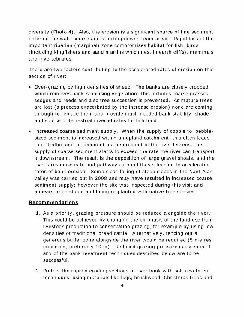
Unfortunately the in-stream habitat is compromised by highly accelerated rates of bank erosion (Photos 2, 3). The outsides of meanders in many locations are being rapidly eroded by the process of block failure, where the river cuts away the toe of the bank and gravity causes the overhanging block of earth to collapse into the river. Although erosion (on the outside of bends) and deposition (on the inside) is a natural process which promotes the desirable natural pool-riffle sequence, accelerated rates of erosion cause poor in-stream habitat for fish.
Resultant over-widening and shallowing of the river channel promotes the settling of fine sediments which compromise fish spawning and invertebrate
4
diversity (Photo 4). Also, the erosion is a significant source of fine sediment entering the watercourse and affecting downstream areas. Rapid loss of the important riparian (marginal) zone compromises habitat for fish, birds (including kingfishers and sand martins which nest in earth cliffs), mammals and invertebrates.
There are two factors contributing to the accelerated rates of erosion on this section of river:
• Over-grazing by high densities of sheep. The banks are closely cropped which removes bank-stabilising vegetation; this includes coarse grasses, sedges and reeds and also tree succession is prevented. As mature trees are lost (a process exacerbated by the increase erosion) none are coming through to replace them and provide much needed bank stability, shade and source of terrestrial invertebrates for fish food.
• Increased coarse sediment supply. When the supply of cobble to pebble-sized sediment is increased within an upland catchment, this often leads to a “traffic jam” of sediment as the gradient of the river lessens; the supply of coarse sediment starts to exceed the rate the river can transport it downstream. The result is the deposition of large gravel shoals, and the river’s response is to find pathways around these, leading to accelerated rates of bank erosion. Some clear-felling of steep slopes in the Nant Alan valley was carried out in 2008 and may have resulted in increased coarse sediment supply; however the site was inspected during this visit and appears to be stable and being re-planted with native tree species.
Recommendations
1. As a priority, grazing pressure should be reduced alongside the river. This could be achieved by changing the emphasis of the land use from livestock production to conservation grazing, for example by using low densities of traditional breed cattle. Alternatively, fencing out a generous buffer zone alongside the river would be required (5 metres minimum, preferably 10 m). Reduced grazing pressure is essential if any of the bank revetment techniques described below are to be successful.
2. Protect the rapidly eroding sections of river bank with soft revetment techniques, using materials like logs, brushwood, Christmas trees and
5
root wads. Advice and demonstrations of techniques are available from the Wild Trout Trust. For longer term protection of the outside of meanders it is recommended that fenced, ungrazed headlands are created and planted with native tree species.
3. Liaise with the owners and managers of forestry plantations in the upper catchment to find out the timescale for harvesting of existing blocks of forestry. Work with the forestry interests to devise a plan to minimise the release of sediments and nutrients during harvesting, and to promote sustainable future forestry practices, such as mixed species plantations with rotational harvesting rather than single-species stands and clear-felling.
Photo 1 Good in-stream habitat – pool and riffle sequence, tree roots in the water and a gravel bed.
6
Photo 2 Block failure erosion on the right bank, possibly caused by a combination of over-grazing and increased coarse sediment supply from the upper catchment.
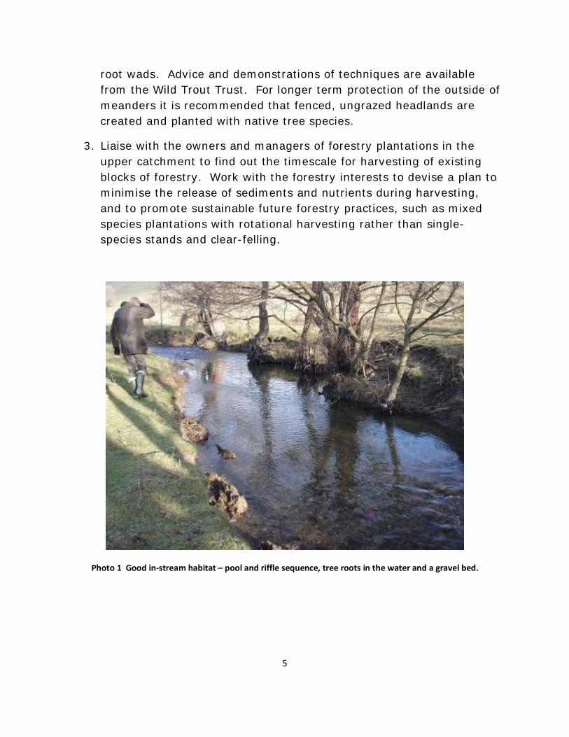
Photo 3 Accelerated erosion – there are two sections of the concrete pipe (right bank) lying on the river bed here indicting the extent or recent bank loss.

7
Photo 4 Summer, low flow conditions – note the fine sediment accumulating on the gravel bed. (Photo: Tony Bostock)
Photo 5 Some materials suitable for bank revetment are available on site.
8
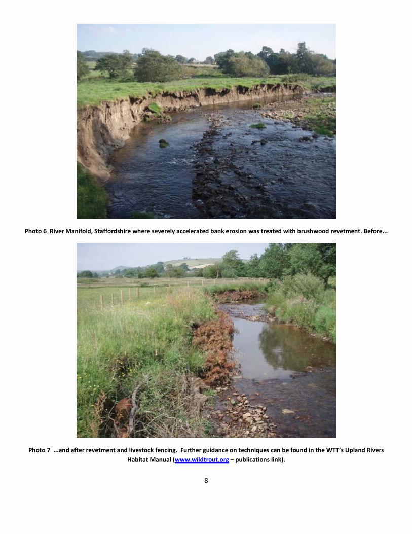
Photo 6 River Manifold, Staffordshire where severely accelerated bank erosion was treated with brushwood revetment. Before...
Photo 7 ...and after revetment and livestock fencing. Further guidance on techniques can be found in the WTT’s Upland Rivers Habitat Manual (www.wildtrout.org – publications link).
9
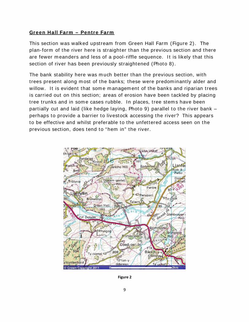
Green Hall Farm – Pentre Farm
This section was walked upstream from Green Hall Farm (Figure 2). The plan-form of the river here is straighter than the previous section and there are fewer meanders and less of a pool-riffle sequence. It is likely that this section of river has been previously straightened (Photo 8).
The bank stability here was much better than the previous section, with trees present along most of the banks; these were predominantly alder and willow. It is evident that some management of the banks and riparian trees is carried out on this section; areas of erosion have been tackled by placing tree trunks and in some cases rubble. In places, tree stems have been partially cut and laid (like hedge laying, Photo 9) parallel to the river bank – perhaps to provide a barrier to livestock accessing the river? This appears to be effective and whilst preferable to the unfettered access seen on the previous section, does tend to “hem in” the river.
Figure 2

10
Because of the straightened nature of the channel here, deeper pool habitat which could hold adult fish is lacking which will restrict the value for angling. This could be improved by the retention of naturally occurring large woody debris within the channel, or by deliberate introduction of flow deflectors to create bed scour and deepen the channel in selected areas; the tree-laying technique could easily be adapted to achieve this by positioning the tops of the trees in the river channel. This provides excellent cover for all life stages of fish, improves invertebrate abundance and diversity and helps moderate water temperatures in hot weather.
The upstream section of this beat is more open (Photo 10). Cut-off meanders and embankments here indicate that past straightening and bed lowering may have taken place. The effect on in-stream habitat is a wide, shallow channel with little adult fish habitat; also grazing and erosion of the banks has removed good marginal habitat greatly reducing the amount of juvenile fish habitat, particularly for trout. Occasional areas of more suitable habitat occur, usually where deeper water occurs on the outside of bends and in the vicinity of large woody debris which has been retained within the river channel (Photo 11).
Discussion with the landowner and farmer, Mr. Peter Lewis, indicated that grayling were caught from this section of river in the past, but have not been recorded since a significant slurry pollution some years ago (late 1980s / early 1990s). Since the visit, EA survey results have been checked (Tony Bostock, pers. comm.) and grayling were recorded in low numbers on all the sections mentioned in this report except Llanfyllin (furthest upstream).
A recent scientific study of grayling genetics in the UK (Dawnay et al., 2011) has shed light on the existing diversity and origins of the populations in different watercourses. The study suggests that grayling in the Severn catchment may constitute a genetically unique population. In order to successfully conserve such populations, it is important that they maintain satisfactory populations within their catchments and make full use of their present and historical areas of distribution. Further investigation into the past and current status of grayling in the Cain system and any necessary restoration options should be considered.

11
Recommendations
1. Introduced large woody debris to the river channel by hinging trees using the same technique as already carried out in places (Photo 9). Where trees will not hinge, tethering with steel cable to create “tree kickers” is an alternative option. Logs could also be introduced to promote bed scour; these can be fixed to the river bed by drilling and pinning with rebar.
2. On the open sections near the upper end of the beat, consider using brushwood revetment along the open banks to reduce erosion and provide in-stream cover for juvenile fish (see Photo 7 above). Stock fencing of these areas should also be carried out to allow a healthy riparian zone to develop. Careful design and positioning of the fence is required (e.g. including ‘sacrificial’ panels in areas vulnerable to flooding and debris accumulation, for ease of repair).
3. Review the status of grayling in the Cain and options for increasing the resilience of this population to events such as the reported slurry pollution. The following action line could be followed:
• Using information provided by EA surveys, angling returns and any other sources, build on the historical information on the grayling population already provided by the landowner.
• Assess man-made barriers between the Cain and other known grayling populations (Vyrnwy, Tanat, Severn) and consider improvements to fish passage which will accommodate grayling.
• Consider a partnership approach with the Severn Rivers Trust, the Grayling Society and the Environment Agency.
12
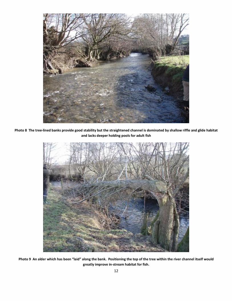
Photo 8 The tree-lined banks provide good stability but the straightened channel is dominated by shallow riffle and glide habitat and lacks deeper holding pools for adult fish
Photo 9 An alder which has been “laid” along the bank. Positioning the top of the tree within the river channel itself would greatly improve in-stream habitat for fish.

13
Photo 10 More open section towards the upstream end of the Green Hall Farm beat
Photo 11 Retention of large woody debris creates good fish-holding habitat.

14
Downstream of Green Hall Farm to Domen Gastell (Llanfechain)
Upstream of Pont Talwrn bridge there is a straightened section of river up to Talwrn Mill lined by alders, ash and willow that have been coppiced and form almost a hedge alongside the river (Photo 12). There are occasional areas of accelerated bank erosion, which could be addressed by bundling the arisings from coppicing and staking these in the eroding areas (Photo 13). Some tree-laying has taken place, as described above; the pros of this are the exclusion of livestock from the river and maintenance of bank stability, but the cons are heavy shading of the river and difficult access for people (e.g. anglers) through the dense hedge that is formed.
Above Talwrn Mill the river has a natural plan-form with meanders and a pool-riffle sequence, providing some good in-stream habitat (Photo 14). There are some areas of excessive erosion, but also a good balance of trees which provide bank stability. Some erosion control attempts may have been made previously (Photo 15).
Photo 12 Straight section below Talwrn Mill with dense tree cover

15
Photo 13 Excessive erosion occurs on some exposed banks
Photo 14 Meandering river with a pool-riffle sequence – good in-stream habitat

16
Photo 15 Some attempts at erosion control with woody debris have been made previously, possibly by EA Operations Delivery team, with some success. Establishing trees is required to provide long-term bank stability.
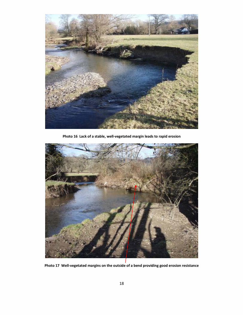
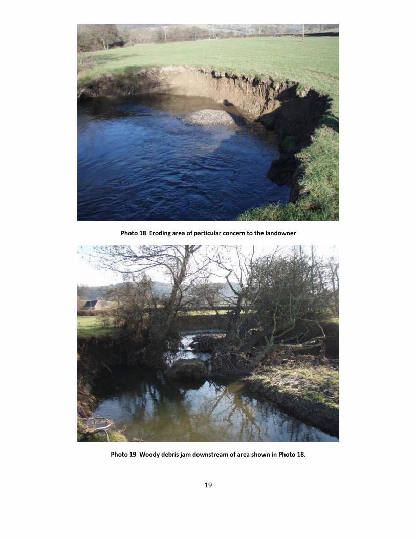
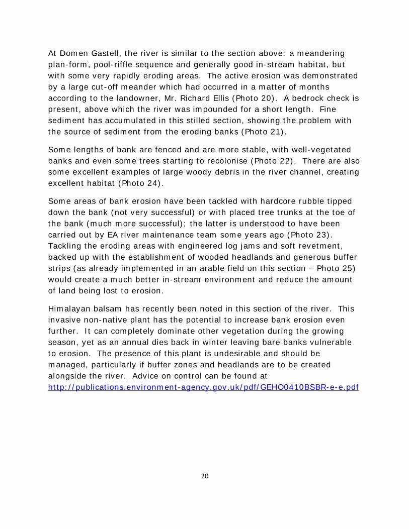
Downstream of Pont Talwrn, the river has an excellent meandering plan-form and pool-riffle sequence giving broadly good in-stream habitat. Unfortunately this is marred by accelerated rates of bank erosion in numerous areas. Such problems often begin with the loss of trees with their bank-stabilising root systems, then persist because of a lack of succession of trees because of grazing right up to the bank edge. It is interesting to contrast the situation in Photos 16 and 17; both are on the outside of bends, yet the situation where there is a headland of trees means the bank remains stable and excessive erosion cannot get a hold.
At one point a tree has been lost, bank erosion has ensued and the tree has ended up as a stable woody debris log jam in the channel just downstream. The landowner is particularly concerned about this location and possible ways of tackling the situation were discussed. As a compromise between retaining the valuable in-stream woody debris and protecting the bank, it is suggested that the trunks of the log jam are cut a few feet above normal water level, leaving the stable in-stream structure in place. The arisings could then be used to tackle the scalloped bank upstream to stabilise the

17
excessive erosion; an engineered log-jam log-Christmas tree revetment approach could be used here.
18
Photo 16 Lack of a stable, well-vegetated margin leads to rapid erosion
Photo 17 Well-vegetated margins on the outside of a bend providing good erosion resistance
19
Photo 18 Eroding area of particular concern to the landowner
Photo 19 Woody debris jam downstream of area shown in Photo 18.
20
At Domen Gastell, the river is similar to the section above: a meandering plan-form, pool-riffle sequence and generally good in-stream habitat, but with some very rapidly eroding areas. The active erosion was demonstrated by a large cut-off meander which had occurred in a matter of months according to the landowner, Mr. Richard Ellis (Photo 20). A bedrock check is present, above which the river was impounded for a short length. Fine sediment has accumulated in this stilled section, showing the problem with the source of sediment from the eroding banks (Photo 21).
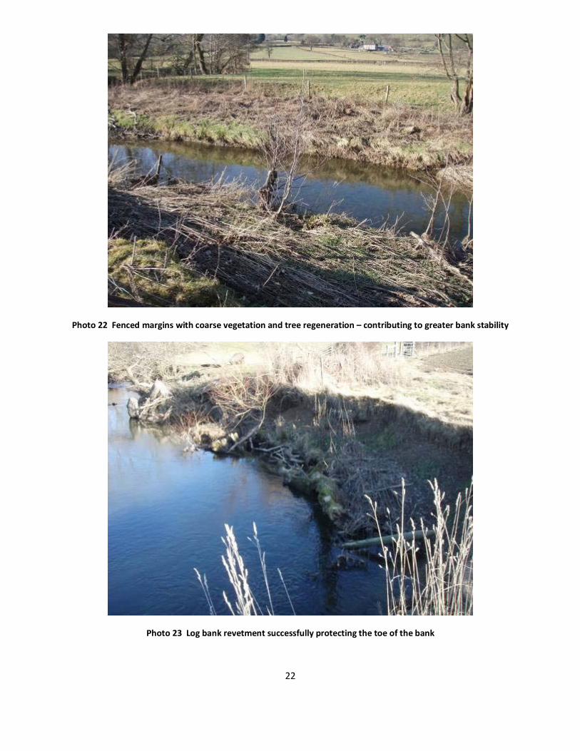
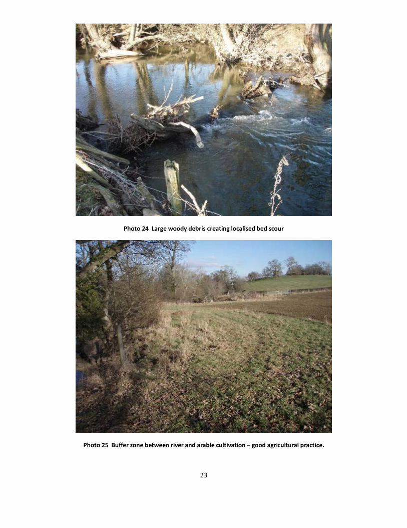
Some lengths of bank are fenced and are more stable, with well-vegetated banks and even some trees starting to recolonise (Photo 22). There are also some excellent examples of large woody debris in the river channel, creating excellent habitat (Photo 24).
Some areas of bank erosion have been tackled with hardcore rubble tipped down the bank (not very successful) or with placed tree trunks at the toe of the bank (much more successful); the latter is understood to have been carried out by EA river maintenance team some years ago (Photo 23). Tackling the eroding areas with engineered log jams and soft revetment, backed up with the establishment of wooded headlands and generous buffer strips (as already implemented in an arable field on this section – Photo 25) would create a much better in-stream environment and reduce the amount of land being lost to erosion.
Himalayan balsam has recently been noted in this section of the river. This invasive non-native plant has the potential to increase bank erosion even further. It can completely dominate other vegetation during the growing season, yet as an annual dies back in winter leaving bare banks vulnerable to erosion. The presence of this plant is undesirable and should be managed, particularly if buffer zones and headlands are to be created alongside the river. Advice on control can be found at http://publications.environment-agency.gov.uk/pdf/GEHO0410BSBR-e-e.pdf

21
Photo 20 Recent cut-off meander
Photo 21 Eroding banks
22
Photo 22 Fenced margins with coarse vegetation and tree regeneration – contributing to greater bank stability
Photo 23 Log bank revetment successfully protecting the toe of the bank
23
Photo 24 Large woody debris creating localised bed scour
Photo 25 Buffer zone between river and arable cultivation – good agricultural practice.

24
Recommendations
1. Intervention to control excessive erosion should be a priority on this section using soft revetment techniques such as log and Christmas tree, brushwood packing and engineered log/rootwad jams. Some examples are illustrated below. The considerable lengths of river affected by the accelerated rates of erosion mean that tackling these in one go is impractical. Probably the best approach would be to undertake a demonstration project with the relevant landowners, and then encourage and facilitate further works. There may also be the possibility of using volunteers co-ordinated through SRT.
2. For the bank stabilisation techniques to be successful in the long term, a change of land use alongside the river is required, e.g. creating un-grazed and uncultivated buffer strips and headlands. Working with landowners and managers to encourage these changes through agri-environment schemes (Glastir) is recommended.
Photo 26 Engineered log-jam on a Canadian stream

25
Figure 3 Root wad, log and Christmas tree revetment (cross-section)
Bank erosion before and after root wad revetment (Afon Dulais near Llandeilo). See WTT Upland Rivers Habitat Manual, Section 5.
26
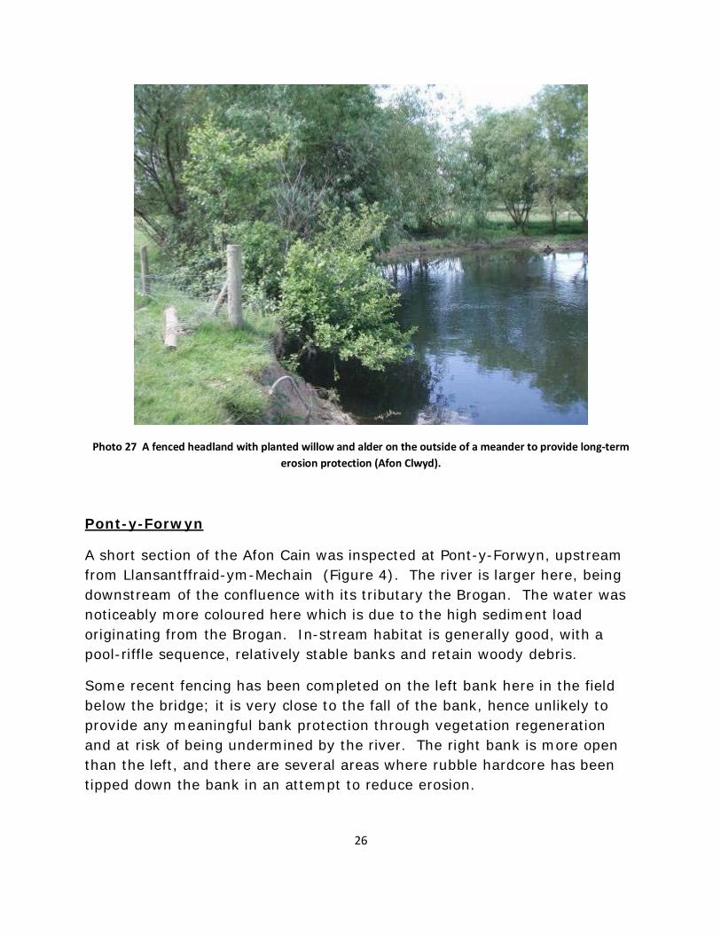
Photo 27 A fenced headland with planted willow and alder on the outside of a meander to provide long-term erosion protection (Afon Clwyd).
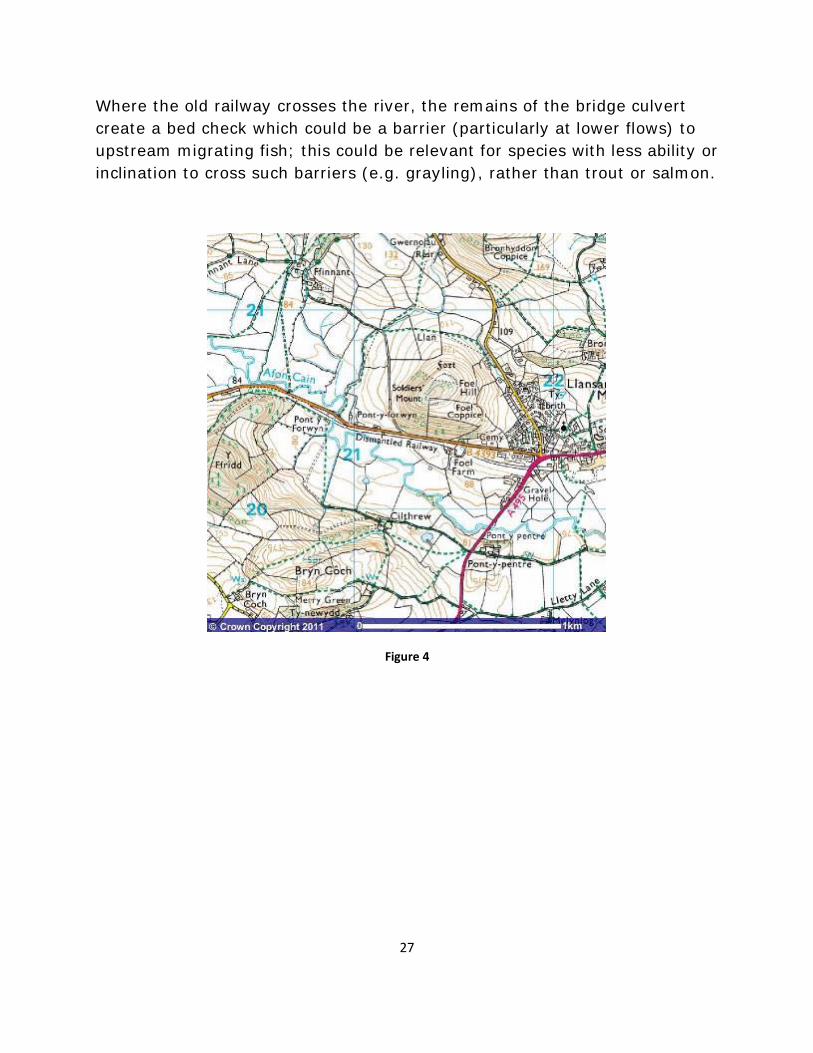
Pont-y-Forwyn
A short section of the Afon Cain was inspected at Pont-y-Forwyn, upstream from Llansantffraid-ym-Mechain (Figure 4). The river is larger here, being downstream of the confluence with its tributary the Brogan. The water was noticeably more coloured here which is due to the high sediment load originating from the Brogan. In-stream habitat is generally good, with a pool-riffle sequence, relatively stable banks and retain woody debris.
Some recent fencing has been completed on the left bank here in the field below the bridge; it is very close to the fall of the bank, hence unlikely to provide any meaningful bank protection through vegetation regeneration and at risk of being undermined by the river. The right bank is more open than the left, and there are several areas where rubble hardcore has been tipped down the bank in an attempt to reduce erosion.
27
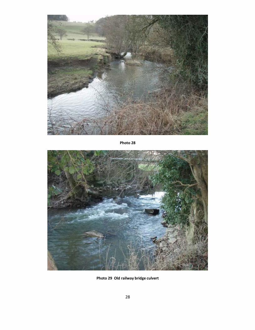
Where the old railway crosses the river, the remains of the bridge culvert create a bed check which could be a barrier (particularly at lower flows) to upstream migrating fish; this could be relevant for species with less ability or inclination to cross such barriers (e.g. grayling), rather than trout or salmon.
Figure 4
28
Photo 28
Photo 29 Old railway bridge culvert

29
4.0 Making it Happen
The Wild Trout Trust may be able to provide further support to put the recommendations in this report into practice. This could include a practical visit to demonstrate techniques, or help preparing a project proposal for works that could be used as a basis for a funding bid. Contact Tim Jacklin [email protected] for further information.
5.0 Acknowledgement
The Wild Trout Trust would like to thank Environment Agency Wales for the support which made this visit possible.
6.0 Disclaimer
This report is produced for guidance only and should not be used as a substitute for full professional advice. Accordingly, no liability or responsibility for any loss or damage can be accepted by the Wild Trout Trust as a result of any other person, company or organisation acting, or refraining from acting, upon comments made in this report.
References
Dawnay, N., Dawnay L., Hughes, R.N., Cove, R. & Taylor, M.I (2011) Substantial genetic structure among stocked and native populations of the European grayling (Thymallus thymallus, Salmonidae) in the United Kingdom. Conservation Genetics DOI 10.1007/s10592-010-0179-4