Embed Size (px)
Citation preview

Produced by and for Hot Science - Cool Talks by the Environmental Science Institute. We request that
the use of these materials include an acknowledgement of the presenter and Hot Science - Cool Talks
by the Environmental Science Institute at UT Austin. We hope you find these materials educational
and enjoyable.
Dr. Daniel Barker
February 25, 2000
Volcanoes:
Killers and Creators
# 3

World map of active volcanoes
(red dots), plate boundaries, land
and oceans. Tilling, R. I.,
Heliker, C., and Wright, T. L.,
1987, Eruptions of Hawaiian
Volcanoes: Past, Present, and
Future. U. S. Geological Survey
[USGS] General Interest
Publication.

LANSAT image, Bay of Naples,
Italy. NASA photo.
N
Piers

1984 cinder cone, Mauna Loa.
National Park Service [NPS]
photo.
Monte Nuovo cinder cone
formed in 1538, Flaming Fields,
Italy. DSB 83-5-13.

Contemporary illustration of
Monte Nuovo eruption, 1538.
Humans and
Livestock

Vesuvius viewed from the Bay of
Naples. DSB 91-23-4.

Fuji viewed from the southeast.
DSB 92-26-3.
1959 Kilauea eruption. NPS
photo.

Mount St. Helens, may 18, 1980.
A. J. Irving photo.

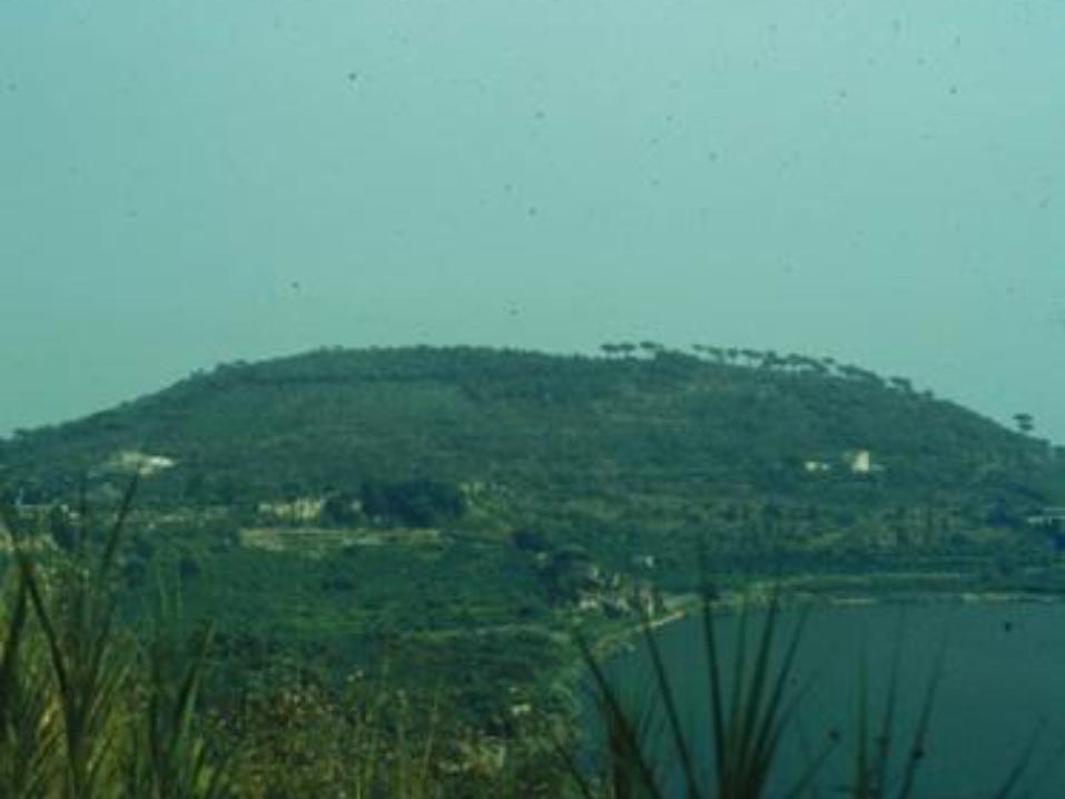
Kilauea lava fountain, 1986.
USGS photo.

Kilauea lava flow, 1959. NPS
photo.

Lava flow on chain of Craters
Road, Kilauea, 1969. NPS
photo.

Home destroyed by 1983 lava
flow, Etna. DSB 88-13-5.

“For sale” sign in lava, Kalapana,
Hawaii. DSB 95-3-6.

House spared by lava flows,
Kalapana, Hawaii. DSB 95-7-29.
Time exposure of eruption at
Piton de la Fournaise, Reunion
Island. Krafft, M., and Krafft,
K., 1979, Volcanoes: Earth’s
Awakening. Maplewood, N. J.,
Hammond, Inc.

Pyroclastic clouds at Arenal,
Costa Rica, 1988. K. A. Kempter
photo.

Eruption of Pinatubo, June 12,
1991. NOAA photo.

Eruption of Pinatubo, June 15,
1991. NOAA photo.

Northeast flank of Pinatubo, June
22, 1991. NOAA photo.
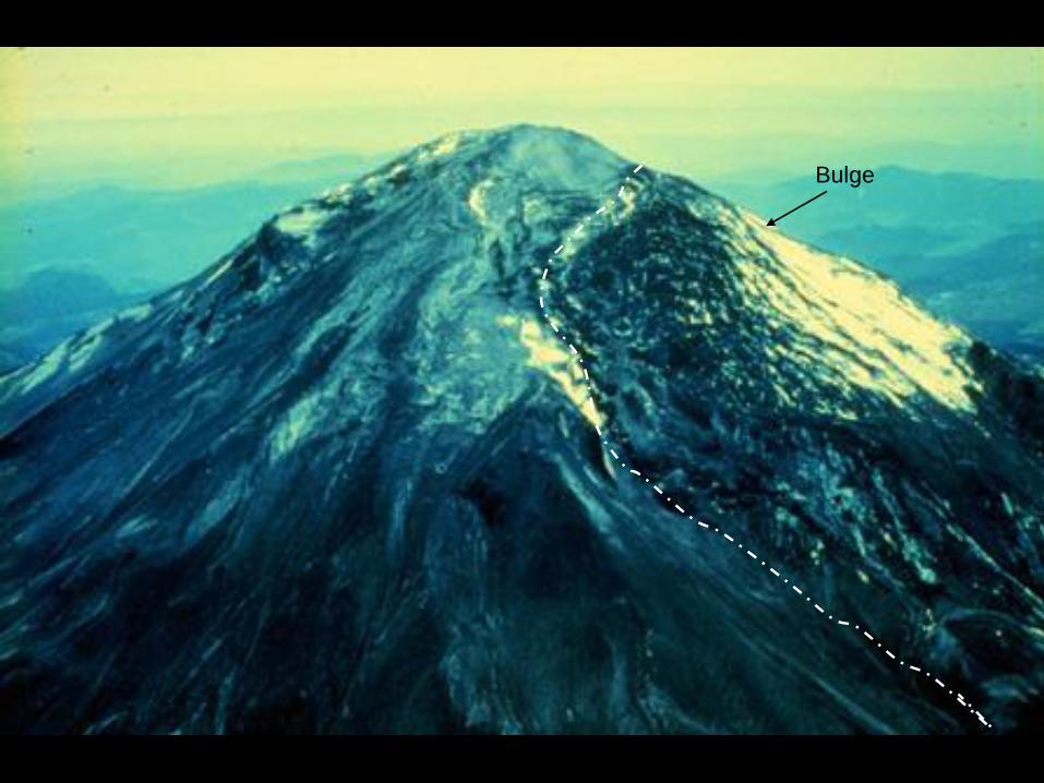
Mount St. Helens, May 3, 1980.
A. J. Irving photo.
Bulge

Start of May 18, 1980, Mount St.
Helens eruption. Washington
Department of Natural Resources
photo.
Actual eruption and
initial gas release
Debris
avalanche

Before and after diagram, Mount
St. Helens. From R. S. Fiske,
Smithsonian Institution.

Mount St. Helens from the north,
1996. DSB 96-6-12.
Lava Dome

Debris avalanche deposits, north
flank of Mount St. Helens. DSB
96-3-26.

View south along Johnston
Ridge, Mount St. Helens
National Volcanic Monument.
DSB 96-5-28.

Aerial view of bridge destroyed
by a mudflow, Philippines,
August 1991. NOAA photo.

Mt. Rainier. DSB 91-7-29.
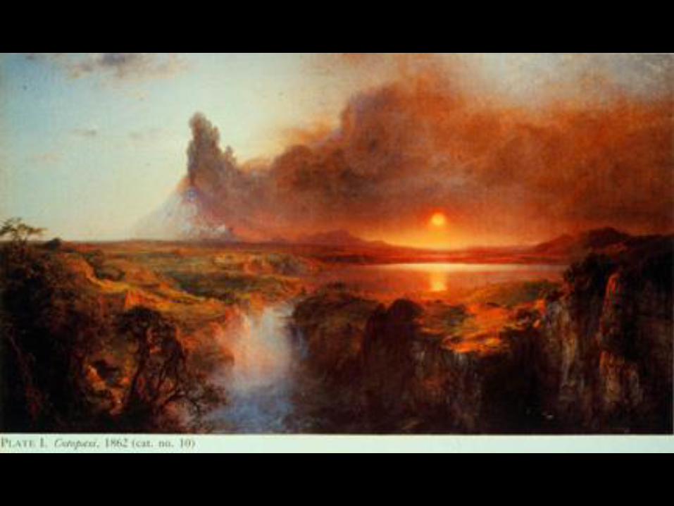
Cotpaxi, by Frederic Church.
Smithsonian Institution photo.

Mount St. Helens eruption cloud,
July 22, 1980. K. Krafft photo.
Ash
Fall
Ash
Plume
Cloud rolling
down right
flank
Mud Flows

1915 eruption of Lassen Peak,
California. B. F. Loomis photo.

1886 ash, Mount Tarawera, New
Zealand. DSB 86-9-8.

Pinatubo airfall at Clark Air
Force Base, Philippines, 1991.
NOAA photo.

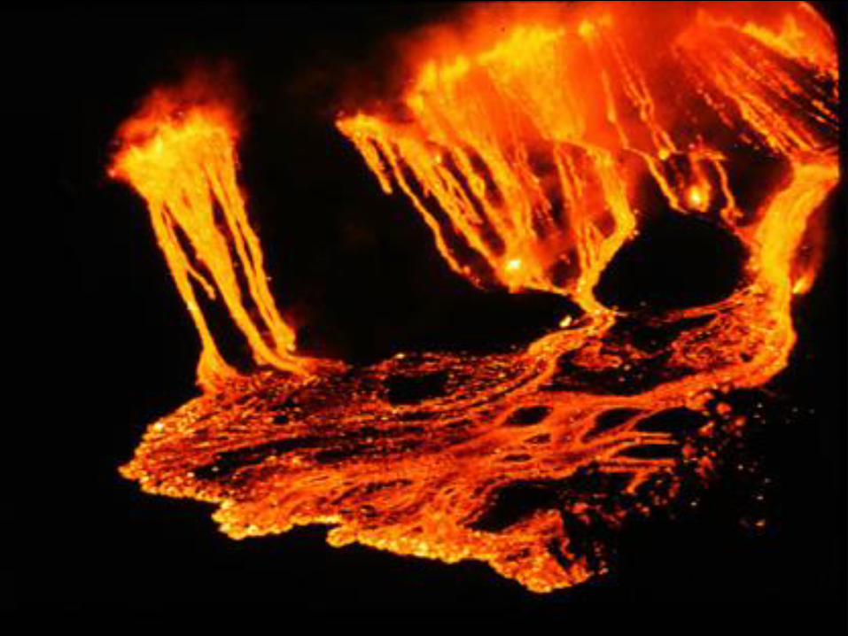
1971 lava fountains, Kilauea.
NPS photo.

1783 fissure, Laki, Iceland. DSB
95-15-8.

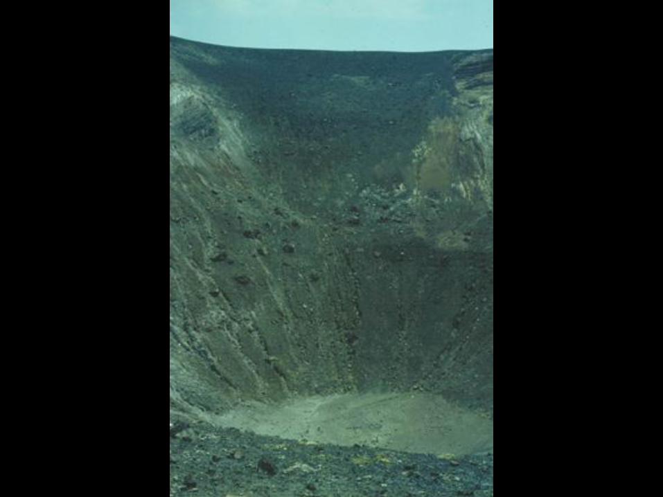
Crater floor and wall, Fogo, Cape
Verdes. DSB 88-10-13.
Houses
Crater Floor

Village in crater, Fogo. DSB 88-
10-7.

Carrying firewood into crater,
Fogo. DSB 88-10-21.
Cone in crater, Fogo. DSB 88-9-
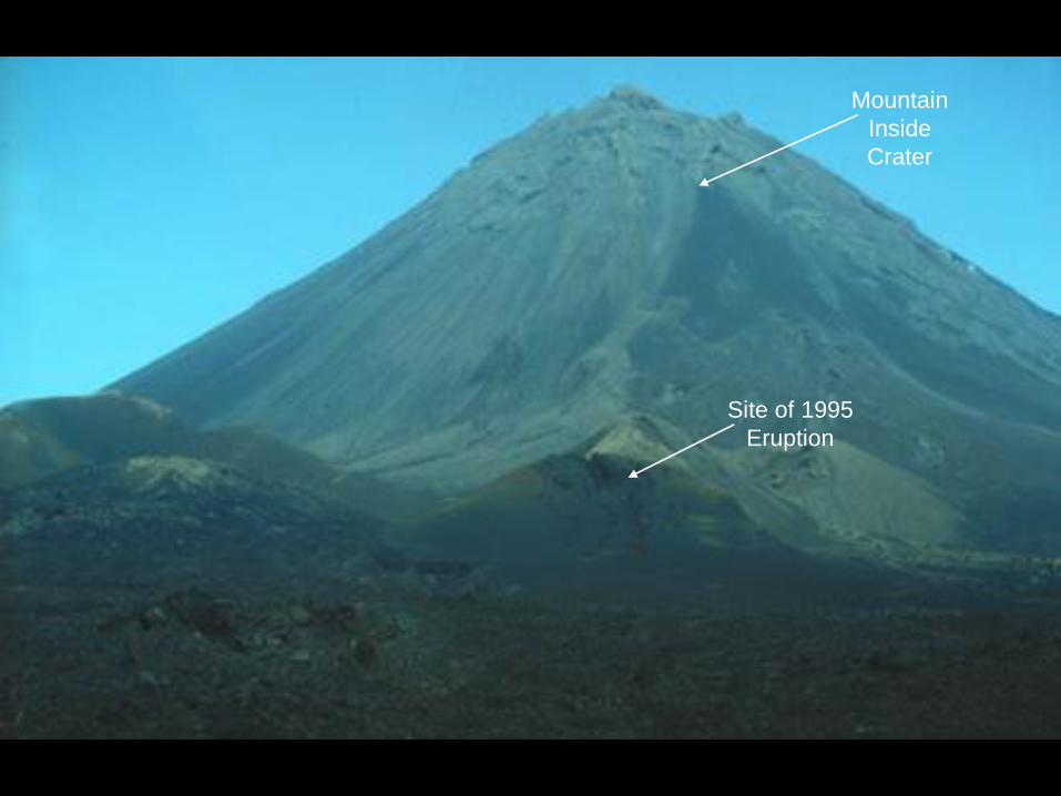
29.
Mountain
Inside
Crater
Site of 1995
Eruption

Kilauea lava and steam plume,
Kalapana. DSB 95-9-10.Waterspout

Algae and bacteria in hot springs,
Lake Rotomahana, New Zealand.
DSB 86-10-34.

Iao Valley, West Maui. DSB 87-
1-7.

Geothermal plant, Wairakei, New
Zealand. DSB 86-4-28.

Diamond in rock. From Wilson,
A. N., 1982, Diamonds: From
Birth to Eternity. Santa Monica,
Gemological Institute of
America.

Sulfur and arsenic sulfides at gas
vent, Solfatara, Flaming Fields,
Italy. DSB 91-20-36.

Lake Averno, a 4,000 year-old
explosion crater in the Flaming
Fields. DSB 83-10-3.

Maori fortifications in a cinder
cone, One ree Hill , Auckland,
New Zealand. DSB 86-2-19.

Citadel of Lipari on a lava dome.
DSB 88-15-11.Hill of lava - foundation
for walled town

Golan Heights, Syria-Isreal
Border, from the northwest. DSB
69-31-13.Lava Field Plateau

Quarry operation for natural
cinder blocks, Castel’ Ottieri,
Italy. DSB 88-8-11.
Cuts

Roman amphitheater carved in
volcanic rock, Sutri, Italy. DSB
88-12-25.

Pico de Teide, Tenerife, Canary
Islands. DSB 88-1-16.

1971 eruption of Kilauea. NPS
photo.

Aerial view of Vulcano from the
northwest. Edizioni Tornatore
photo.
1739
Lava
Flow
Area currently
densely populated

Thermal image of Vulcano.
NASA photo.
Yellow at
center of
volcano

Vulcano viewed from Lipari.
DSB 88-14-36.
Vulcano
Crater

Overlooking Vulcano to the north
from the crater rim. DSB 88-16-
18.

1889 eruption of Vulcano. After
Silvestri and Mercalli, 1891.
Crater, Vulcano, 1983. DSB 83-
12-3.

Dark 1888-1890 deposits on
crater rim, Vulcano. DSB 88-16-
5.
Cross Section of the Inner Slopes of Vulcano
Deposits from
1888-1890
Eruption
Older
Eruption
Material

Large block from 1888-1890
eruptions on crater rim, Vulcano.
DSB 88-16-3.

Gas vents on rim of crater,
Vulcano. DSB 88-16-11.

Gas vent in crater, Vulcano,
1988. DSB 88-16-6.

Closeup of gas vent, Vulcano.
DSB 88-15-35.Vent

Graph, maximum temperature
(degrees Celsius) of Vulcano gas
vents through time.

Tourists bathing in the Hippo
Pool, Vulcano. DSB 83-11-4.

Hot spring in pavement, Vulcano.
DSB 83-11-17.

Earthquake damage to pier,
Vulcano. DSB 83-12-12.

Vesuvius in 1822, by an
anonymous artist. From Krafft,
M. 1993. Volcanoes: Fire from
the Earth. H. N. Abrahms, New
York.

Further reading:
Chester, D., 1993, Volcanoes and Society. Edward Arnold, London.
Decker, R. W., and Decker, B .B., 1997, Volcanoes. 3rd edition, W. H. Freeman & Co.
New York.
Fisher, R. V., 1999, Out of the Crater. Princeton Univ. Press.
Fisher, R. V., Heiken, G., and Hulen, J. B., 1997, Volcanoes: Crucibles of Change.
Princeton Univ. Press.
Francis, P.,1993, Volcanoes: A Planetary Perspective. Oxford University Press
Harris, S. L., 1988, Fire Mountains of the West: the Cascade and Mono Lake
Volcanoes. Mountain Press Publishing Co., Missoula, Montana.
Krafft, Maurice, 1993, Volcanoes: Fire from the Earth. Harry N. Abrams, Inc., New
York.
Sigurdsson, H., 1999, Melting the Earth: the History of Ideas on Volcanic Eruptions.
New York, Oxford Univ. Press.
Sigurdsson, H., (ed.), 1999, Encyclopedia of Volcanoes. Academic Press, New York.
Simkin, T., and Siebert, L., 1994, Volcanoes of the World 2nd edition. Geoscience
Press, Tucson, Arizona.
Wright, T. L., and Pierson, T. C., 1992, Living with Volcanoes: The U.S. Geological
Survey’s Volcano Hazards Program. USGS Circular 1073.

Thought Questions
1. On Mars and probably on Venus, the tallest mountains are volcanoes, but here on
the Earth, the highest mountains are not volcanoes. List some possible reasons for
volcanoes being less tall on the Earth than on some other planets. (Differences in
weathering and erosion rates of volcanic rocks on different planets due to different atmospheric
compositions and weather patterns. Different rock compositions. Variability in tectonic and
volcanic activity.)
2. What actions would you take if you were told that a volcano near where you live
was very likely to erupt within the next month? Would your plans change if you were
told that the eruption could occur anytime within the next 100 years? If so, what
would you do differently? (Would you sell your property and move to a less volcanically
active area in either situation? Why?)
3. Imagine that a stranger comes to your farm, tells you that that mountain over there
is a volcano that will erupt soon, and offers to buy your land at a very low price.
What questions should you ask the stranger, and where else would you seek advice? (How did he/she come by this information (is it trustworthy)? Who does he/she work for (is there
an underlying motive)? What evidence does he/she have that would come to that conclusion?
One should probably seek more information from the USGS (or local Geological Survey), local
government, and a local university’s geology department, before making any drastic decisions.)

Thought Questions4. One of the best, although not perfect, ways to predict what a volcano will do in the future is to study how it
has acted in the past. What evidence would you look for? (Old lava flows, pyroclastic bombs, ash layers,
any ancient written or painted accounts of activity.)
5. Some, but not enough, volcanoes are now being monitored. That means their behavior is closely watched.
Among the symptoms of unrest at a volcano are:
(a) increasing numbers of earthquakes, closer and closer to the surface
(b) slow and very small changes in height and steepness of a volcano
(c) increasing temperatures of gas, spring water, and soil around a volcano
(d) trees and other plants beginning to die on some parts of the volcano
Think of inexpensive ways to measure each of these changes. (Volunteers and/or park rangers to monitor
surrounding flora, water, soil. Automated seismic instrumentation placed in proximity to the volcano, images
from satellites.)
When questioned about the portrayal of volcanism in popular media and Hollywood, Professor Barker said
that most movies are grossly inaccurate. However, he did give Dante’s Peak a fairly high rating relative to all
other movies (a “C” for science). Although the depiction of a mix of fluid lava flows with explosive eruptions is
not accurate, it did offer a good depiction of pyroclastic flows.
Web sites:
USGS Volcano Hazards Survey http://volcanoes.usgs.gov/
Smithsonian Institution’s Global Volcanism Project http://www.volcano.si.edu/gvp
Austin’s own volcano from the Cretaceous Period - Information on Pilot Knob (Go to Stop 5)
http://www.utexas.edu/research/beg/GIS/demo/vft/vftHOME2.htm

Professor Daniel S. Barker
Dan Barker received degrees from Yale, Cal Tech, and Princeton, and has
been at the University of Texas at Austin since 1963. He became Professor
Emeritus in 1999. He has published one book and more than 50 papers.
His teaching covered thirteen different courses on volcanoes, igneous
rocks, geochemistry, mineralogy, and general geology, and he continues
research on these topics. Professor Barker has taught over 5000 students
and has received five awards for teaching excellence from UT. Field trips
have taken him from Greenland, Iceland, and Scandinavia through France,
Germany, and Italy to the Canary and Cape Verde Islands and eastern and
southern Africa, and from Hawaii to Japan, New Zealand, central America
and much of North America. Enthusiasm for photography and history as
well as geology resulted in the images of volcanic regions sampled in this
lecture.


![Horror killers[1]](https://img.pdfslide.us/doc/110x75/557dbfc2d8b42a8a188b4f2e/horror-killers1.jpg)