Embed Size (px)
Citation preview
190724_updated_CP_Cascadia_Offsetting_Final.docx
July 24, 2019
Prepared for:
Canadian Pacific Railway Building 9 1670 Lougheed Highway Port Coquitlam, BC V3B 5C8
Viterra-Cascadia Terminal Capacity Expansion Project – Offsetting Plan
Prepared by:
Hemmera Envirochem Inc. 4730 Kingsway, 18th Floor Burnaby, BC, V5H0C6 T: 604.669.0424 hemmera.com
Pertains to: VFPA file No.: 19-006 DFO file No.: 19-HPAC-00243
Canadian Pacific Railway Viterra-Cascadia Terminal Capacity Expansion Project – Offsetting Plan 19-HPAC-00243
July 2019 Page | i
190724_updated_CP_Cascadia_Offsetting_Final.docx
TABLE OF CONTENTS
LIST OF ACRONYMS AND ABBREVIATIONS.......................................................................................... IV
LIST OF SYMBOLS AND UNITS OF MEASURE ....................................................................................... IV
1.0 INTRODUCTION .............................................................................................................................. 1
2.0 RESIDUAL SERIOUS HARM TO FISH .......................................................................................... 4 2.1 Destruction and Permanent Alteration of Fish Habitat ........................................................ 4
2.1.1 Destruction of Fish Habitat ..................................................................................... 5 2.1.2 Permanent Alteration of Fish Habitat ..................................................................... 5 2.1.3 Summary ................................................................................................................ 6
2.2 Summary of Residual Harm ................................................................................................ 8
3.0 OFFSETTING APPROACH ............................................................................................................. 9
4.0 SELECTION OF OFFSETTING MEASURES ............................................................................... 10 4.1 Objectives ......................................................................................................................... 10
4.1.1 Guiding Principles for Offsetting .......................................................................... 10 4.2 Fisheries Management Objectives and Local Management Priorities .............................. 11 4.3 Meetings and Sessions with Indigenous Communities ..................................................... 11 4.4 Project Offsetting Meeting with VFPA ............................................................................... 12 4.5 Project Information Meeting with DFO Assessor .............................................................. 12 4.6 Reconnaissance-Level Field Review with DFO Assessor ................................................ 13 4.7 Proposed Offsetting Measures ......................................................................................... 13
4.7.1 Alignment with Guiding Principles ........................................................................ 14 4.7.2 Riparian Planting Plan ......................................................................................... 16 4.7.3 Shallow Reef Complex Design ............................................................................ 17
5.0 AMOUNT OF OFFSETTING REQUIRED ..................................................................................... 21 5.1 Relative Habitat Productivity Values ................................................................................. 21 5.2 Habitat Affected by the Project ......................................................................................... 22
5.2.1 Riparian Habitat ................................................................................................... 22 5.2.2 Intertidal Habitat ................................................................................................... 22 5.2.3 Subtidal Habitat .................................................................................................... 23 5.2.4 Proposed Offsetting Habitats –Riparian Planting and Shallow Rock Reefs ........ 23
5.2.4.1 Riparian Planting ............................................................................... 23 5.2.4.2 Shallow rock reefs ............................................................................. 23
5.3 Offsetting Requirements ................................................................................................... 24 5.3.1 Habitat Balance Summary ................................................................................... 26 5.3.2 Accounting for Existing Habitat Values ................................................................ 26
5.3.2.1 Riparian Plantings .............................................................................. 26
Canadian Pacific Railway Viterra-Cascadia Terminal Capacity Expansion Project – Offsetting Plan 19-HPAC-00243
July 2019 Page | ii
190724_updated_CP_Cascadia_Offsetting_Final.docx
5.3.2.2 Shallow Rock Reef ............................................................................ 26 5.3.3 Time Lag and Uncertainty .................................................................................... 27 5.3.4 Offsetting Quantities / Habitat Balance ................................................................ 28
6.0 OFFSETTING IMPLEMENTATION AND MONITORING ............................................................. 29 6.1 Implementation Schedule ................................................................................................. 29 6.2 Avoidance and Mitigation Measures ................................................................................. 29
6.2.1 Avoidance Measures ........................................................................................... 29 6.2.2 Construction Timing ............................................................................................. 30 6.2.3 Mitigation Measures ............................................................................................. 30
6.3 Habitat Effectiveness Monitoring and Reporting ............................................................... 31 6.3.1 Measures of Success ........................................................................................... 31
6.3.1.1 Riparian Planting ............................................................................... 31 6.3.1.2 Shallow Reef Complex ...................................................................... 32
6.3.2 Maintenance Program .......................................................................................... 32 6.3.2.1 Riparian Planting ............................................................................... 32
6.3.3 Post-construction Monitoring Program ................................................................ 33 6.3.3.1 Riparian Planting ............................................................................... 33 6.3.3.2 Shallow Reef Complex ...................................................................... 33
6.3.4 Reporting .............................................................................................................. 34 6.3.4.1 Post-construction / As-built Reporting ............................................... 34 6.3.4.2 Habitat Effectiveness Reporting ........................................................ 34
7.0 CONTINGENCY PLANNING ......................................................................................................... 35
8.0 COST ESTIMATE FOR OFFSETTING ......................................................................................... 36
9.0 TENURE ........................................................................................................................................ 37
10.0 CLOSURE ...................................................................................................................................... 39
11.0 REFERENCES ............................................................................................................................... 40
LIST OF TABLES (WITHIN TEXT)
Table 2-1 Summary of Affected Habitats ............................................................................................ 4 Table 2-2 Summary of Residual Harm and Offsetting Requirements ................................................. 7 Table 4-1 List of Plant Species and Pot Sizes .................................................................................. 17 Table 5-1 Relative Habitat Values ..................................................................................................... 21 Table 5-2 Relative Habitat Value of Affected and Offsetting Habitats .............................................. 22 Table 5-3 Summary of Habitat Offsetting Requirements .................................................................. 25 Table 5-4 Offsetting Habitat Summary .............................................................................................. 28 Table 8-1 Proposed Cost Estimate for Offsetting.............................................................................. 36
Canadian Pacific Railway Viterra-Cascadia Terminal Capacity Expansion Project – Offsetting Plan 19-HPAC-00243
July 2019 Page | iii
190724_updated_CP_Cascadia_Offsetting_Final.docx
LIST OF FIGURES (WITHIN TEXT)
Figure 1 Viterra-Cascadia Terminal Capacity Expansion Project, located in the Burrard Inlet, Burnaby, BC. ....................................................................................................................... 2
Figure 2 Project Footprint and Fish Habitat Impact Summary .......................................................... 3 Figure 3 Approach to Preparing the Offsetting Plan ......................................................................... 9 Figure 4 Single Reef Plan View and Typical Cross-section ............................................................ 18 Figure 5 Fish Habitat Offsetting Plan .............................................................................................. 20 Figure 6 Existing and Proposed Lease Areas ................................................................................. 38
Canadian Pacific Railway Viterra-Cascadia Terminal Capacity Expansion Project – Offsetting Plan 19-HPAC-00243
July 2019 Page | iv
190724_updated_CP_Cascadia_Offsetting_Final.docx
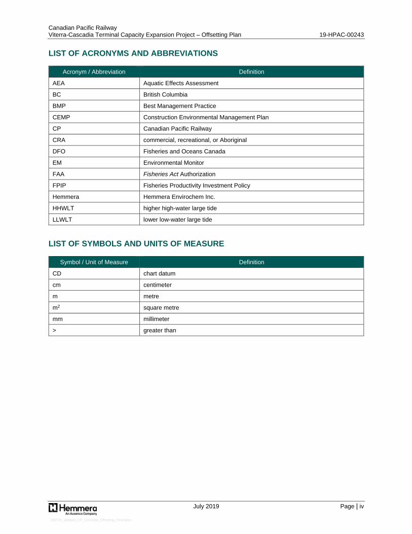
LIST OF ACRONYMS AND ABBREVIATIONS
Acronym / Abbreviation Definition
AEA Aquatic Effects Assessment
BC British Columbia
BMP Best Management Practice
CEMP Construction Environmental Management Plan
CP Canadian Pacific Railway
CRA commercial, recreational, or Aboriginal
DFO Fisheries and Oceans Canada
EM Environmental Monitor
FAA Fisheries Act Authorization
FPIP Fisheries Productivity Investment Policy
Hemmera Hemmera Envirochem Inc.
HHWLT higher high-water large tide
LLWLT lower low-water large tide
LIST OF SYMBOLS AND UNITS OF MEASURE
Symbol / Unit of Measure Definition
CD chart datum
cm centimeter
m metre
m2 square metre
mm millimeter
> greater than
Canadian Pacific Railway Viterra-Cascadia Terminal Capacity Expansion Project – Offsetting Plan 19-HPAC-00243
July 2019 Page | 1
190724_updated_CP_Cascadia_Offsetting_Final.docx
1.0 INTRODUCTION
Canadian Pacific Railway (CP) is proposing a rail track extension to the Viterra-Cascadia Terminal (Terminal) along the south shore of Burrard Inlet, just west of Second Narrows in Burnaby, BC. Freight volumes in and out of the Terminal have resulted in a shortage of track capacity during the peak shipping season. The purpose of the proposed extension is to improve overall mainline and switching operations at the Terminal facility. The increased track length will also add capacity for additional grain product unloading. The proposed track extension would increase the length of the existing third track by approximately 300 metres (m), with the western extent located approximately 700 m east of the Terminal, as shown on Figure 1. Herein, ‘the Project’, is used to refer to the Viterra-Cascadia Terminal Capacity Expansion Project and ‘Project Area’ is used to refer to the Project footprint, are shown in Figure 2.
The proposed track extension will involve widening of the existing CP rail embankment, including placement of clean, engineered, fill material extending into Burrard Inlet resulting in permanent alteration and some permanent and temporary loss of intertidal and subtidal fish habitat in the marine environment, indicated in Figure 2.
CP retained Hemmera Envirochem Inc. (Hemmera) to assess the effects of the Project on fish habitat resources and describe avoidance and mitigation measures, consistent with the requirements for a Vancouver Fraser Port Authority (VFPA) Project and Environmental Review (PER) submission and Navigation Protection Act work assessment. Furthermore, Hemmera has been tasked with preparing a serious harm assessment to determine offsetting requirements, development of an Offsetting Plan with suitable measures and quantities to offset residual serious harm, and submission of a Fisheries Act Authorization (FAA) application pursuant to Section 35(2)(b) of the Fisheries Act.
This Offsetting Plan summarizes residual serious harm to fish that is anticipated to result from the Project, which is further detailed in the Viterra-Cascadia Terminal Capacity Expansion Project – Marine Fish and Fish Habitat Assessment (or Habitat Assessment; Hemmera 2019a), and also describes the approach to offsetting, and details the proposed offsetting measures as described in the Fisheries Productivity Investment Policy: A Proponent’s Guide to Offsetting (DFO 2013a). Furthermore, it is noted that this document replaces an earlier version of the Offsetting Plan (dated June 19, 2019) which has since been updated to include a summary of field survey efforts (kelp surveys) conducted in July 2019, and modifications to the assessment of potential project effects and required offsetting.
Path: S:\Geomatics\Projects\103396\02\mxd\Cascadia - Viterra Capacity Improvement Project\Fig1__103396_02_ProjectLocation_190611.mxd
Pro ductio n Date: Jun 11, 2019
Pa ge Size: 11" x 17"
103396-02 Figure 1
NAD 1983 CSR S UTM Zo n e 10N
Burrard Inlet
CASCADIATER MINAL
CP R O W
CA-124
CA-125
N WILLINGDO N AVE
SECOND NARROWS BRIDGE
R AILWAY ST
FR ANKLIN ST
EDINBUR GH ST
BETA AVE
FELLO WES ST
ALPHA AVE
MOUNTAIN HWY
N RO SSER AVE
ALBER T ST
N SKEENA ST
MILLER DR
TRANS-CANADA HWY
AMHER ST AVE
BRIDGEWAY
MACDO NALD AVE
ESMOND AVE
MAIN ST
CANBERR A AVE
GAMMA AVER OSSER AVE
N INGLETON AVE
N CARLETON AVE
N BOUNDAR Y RD
GILMO RE AVE
N GILMO RE AVE
MADISON AVE
CASSIAR ST
SKEENA ST
WILLINGDO N AVE
N ESMO ND AVE N M
ACDONALD AVE
KOOTENAY ST
CAR LETO N AVE
INGLETO N AVE
N MADISON AVE
N KO OTENAY ST
BAR R O W ST
N CASSIAR ST
ORWELL ST
TR IUMPH ST
TR INITY ST
HARBO UR AVE
BOUNDAR Y RD
EMPIR E DR
PENZANCE DR
PANDO R A ST
YALE ST
DO MINIO N ST
BAY ST
SPICER RD
UNNAMED LANE
CAMBR IDGE ST
ETO N ST
O XFO R D ST
DUNDAS ST
MCGILL ST
N GAMMA AVE
R IVER SIDE DR W
CO LUMBIA ST
Project Location
Casca dia - Viterra Capacity Im pro vem en t Pro jectBurrard In let, Burn a b y, BC
Map Exten t
0 2.5 5Kilo m etres
Legen d
±1:10,000
0 100 200 300 400 500Metres
- Co n ta in s in fo rm a tio n licen sed un der the O pen Go vern m en t Licen ces -Pro vin ce o f British Co lum b ia a n d City o f Va n co uver- Pro po sed Pro ject Features: AECO M, 2019- Aeria l Im a ge: City o f Va n co uver, 2015; ESR I World Im a gery- In set Basem a p: ESR I Wo rld To po graphic Map
So urces
1. All m apped fea tures are appro xim a te a n d sho uld b e used fo r discussio npurposes o n ly.2. This m ap is n o t in ten ded to b e a “sta n d-a lo n e” do cum en t, b ut a visua l a ido f the in fo rm a tio n co n ta in ed within the referen ced R epo rt. It is in ten ded tob e used in co n jun ctio n with the sco pe o f services a n d lim itatio n s describ edtherein .
No tes
Pro po sed Track Exten sio nPro ject Fo o tprin tCP Milea geExistin g CP R a ilwa y
Path: S:\Geomatics\Projects\103396\02\mxd\Fig2__103396_02_FishHabitatImpactSummary_190724.mxd
P roduction Da te: Jul 24, 2019
P a ge Size: 11" x 17"
103396-02 Figure 2
N AD 1983 CSRS UTM Z one 10N
Burrard Inlet
N EW HHW LT
LLW MTMW LHHW MT
LLW LT
HHW LT
HHW LT
LLW LT
HHW MTMW L
LLW MT
DESTRUCTION - RIPARIAN1,500 m 2
P ERMAN EN T ALTERATION - MARIN E IN TERTIDAL3,389 m 2
DESTRUCTION - MARIN E IN TERTIDAL1,679 m 2
P ERMAN EN T ALTERATION - MARIN E SUBTIDAL (W ITHIN KELP BED)331 m 2
P ERMAN EN T ALTERATION - MARIN E IN TERTIDAL (W ITHIN KELP BED)214 m 2
CASCADIA TERMIN AL
CP LEASE ROW
[P LAN V-4324(02)]
Project Footprintand Fish Habitat Impact Summary
Viterra -Ca sca dia Term ina l Ca pa city Expa nsion P roject
Burra rd Inlet, Burna by, BC
Legend
±1:1,000
0 10 20 30 40 50Metres
Construction Z one Lim itP roposed Tra ck ExtensionKelp Bed Extent (2019)Shorewa rd Kelp Ded Extent (2019)Exca va tion Area Beyond Gra ding StructureP roposed Ripra pP roposed Tra ck Rem ova lP roposed W a lkwa y for TurnoutTem pora ry P a d ExtensionExisting CP Ra ilwa yP roposed Higher High W a ter La rge Tide (HHW LT)Tide LineCP Right-of-W a yCP Lea se Right-of-W a y
Fish Habitat ImpactDestruction - Ma rine Intertida lDestruction - Ripa ria nP erm a nent Altera tion - Ma rine Intertida lP erm a nent Altera tion - Ma rine Intertida l (W ithin Kelp Bed)P erm a nent Altera tion - Ma rine Subtida l (W ithin Kelp Bed)
- Conta ins inform a tion licensed under the Open Governm ent Licences -P rovince of British Colum bia a nd City of Va ncouver- P roposed P roject Fea tures: AECOM, 2019- Aeria l Im a ge: City of Va ncouver, 2015
Sources
1. All m a pped fea tures a re a pproxim a te a nd should be used for discussionpurposes only.2. This m a p is not intended to be a “sta nd-a lone” docum ent, but a visua l a idof the inform a tion conta ined within the referenced Report. It is intended tobe used in conjunction with the scope of services a nd lim ita tions describedtherein.
N otes
Canadian Pacific Railway Viterra-Cascadia Terminal Capacity Expansion Project – Offsetting Plan 19-HPAC-00243
July 2019 Page | 4
190724_updated_CP_Cascadia_Offsetting_Final.docx
2.0 RESIDUAL SERIOUS HARM TO FISH
A detailed evaluation of the Project’s anticipated residual serious harm to fish is included within the Habitat Assessment (Hemmera 2019a). Also included in the Habitat Assessment is a detailed summary of existing fish habitat values at the Project Area, including a description of fish, fish habitat, and potential species at risk.
As described in the Habitat Assessment, serious harm is defined as: “the death of fish or the permanent alteration to, or destruction of, fish habitat of a spatial scale, duration, or intensity that limits, diminishes, or precludes the ability of fish to use that habitat for one or more of their life processes” (DFO 2013a).
The Habitat Assessment considers potential serious harm to fish resulting from interactions between the Project activities and fish and fish habitat after the implementation of avoidance and mitigation measures, using five criteria to characterize potential serious harm to fish and fish habitat:
Habitat availability
Habitat value
Habitat dependency
Localized effects
Anticipated residual harm to fish
2.1 Destruction and Permanent Alteration of Fish Habitat
As summarized in the Habitat Assessment, the Project will result in the permanent loss/destruction or permanent alteration of marine intertidal and subtidal habitat with the potential to support commercial, recreational and Aboriginal (CRA) fish species. A total of 7,113 m2 of habitat is expected to be adversely affected by Project Area preparation, temporary work pad construction/decommissioning, dredging, and infilling (Table 2-1).
Table 2-1 Summary of Affected Habitats
Habitat Type Habitat Affected (m2)
Riparian 1,500
Intertidal 5,282
Subtidal 331
Total 7,113
A cautious approach has been applied for assessment of these footprint impact areas. For instance, this assessment of affected habitats assumes that dredging will alter 733 m2 of intertidal habitat beyond the permanent infill area (grading structure); however, this is a conservative estimate as geotechnical results suggest that the actual dredging footprint will likely be smaller. Furthermore, an additional 2 m impact buffer was applied during calculation of the intertidal/subtidal footprint areas to account for any minor field changes or variation in anticipated versus actual footprint areas during Project construction. This approach is intended to ensure that this assessment of affected habitats does not underestimate actual footprint effects and; furthermore, that any subsequent offsetting is more than sufficient. The final footprint area will be quantified through survey at the end of Project construction and compared against the impact areas provided within this Offsetting Plan, to ensure that the final habitat balance (including offsetting requirements) are as anticipated.
Canadian Pacific Railway Viterra-Cascadia Terminal Capacity Expansion Project – Offsetting Plan 19-HPAC-00243
July 2019 Page | 5
190724_updated_CP_Cascadia_Offsetting_Final.docx
2.1.1 Destruction of Fish Habitat
Fish habitats (riparian and marine intertidal/subtidal) overlapping with the permanent upland footprint of the proposed track expansion area will be fully modified by Project construction and no longer function as fish habitat. Project Area preparation will result in the full loss of the existing marine riparian habitat, over a length of 300 m and an average width of 5 m. Infilling will convert some existing intertidal habitat areas into upland, to facilitate expansion of the existing track base. In total, 3,179 m2 of existing fish habitat will be destroyed by the Project, including 1,500 m2 of lower value marine riparian habitat and 1,679 m2 of intertidal hard substrates. Although a bull kelp bed is known to overlap to some extent with intertidal habitats within the Project Area, this overlap is limited to the temporary fill footprint areas (i.e., temporary work pad) and does not represent destruction of fish habitat. More information on kelp bed effects are discussed below, in Section 2.1.2.
2.1.2 Permanent Alteration of Fish Habitat
Permanent alteration applies where existing marine intertidal/subtidal habitats will be modified by the Project, but will remain available as fish habitat following Project completion. As a conservative approach, permanent alteration is considered to apply not only to the remainder of infilling (i.e., where fill slopes remain as marine aquatic habitat), but also the temporary work pad and dredging areas that extend beyond the infill area. Only temporary alteration is anticipated to result from operation of equipment within the kelp bed during construction, as any impacts on bull kelp plants will follow latter stages of the growth and primary spore-production season (e.g., September). As a result, no persistent damage to the bull kelp bed is expected and any temporary changes in habitat structure and cover are unlikely to persist for more than one year given the propensity for spore deposition by tidal current action from nearby and extensive kelp beds.
Of the permanent alteration effects from dredging and infilling (permanent and temporary), permanent infilling will be the most notable alteration, as existing natural intertidal hard substrates in the intertidal will be converted to a riprap slope. Although the temporary work pad (i.e., barge landing platform) will be decommissioned after use and portions not overlapping with the new riprap slopes will be removed, complete removal of all temporary fill is unlikely. Similarly, dredged areas extending past the new riprap slopes are expected to be minimally altered and will recover most of their previous habitat function over time. Although it is reasonable to describe these portions of the work pad and dredging footprints as temporary effects, both are included as permanent alteration to further ensure a robust and defensible accounting of residual effects.
Permanent alteration resulting from the Project, excluding any fish habitat alteration that will result from proposed offsetting (detailed later in this Offsetting Plan; see Section 5.3.2.2), is expected to total 3,934 m2. Of the 3,934 m2 of existing fish habitat that will be permanently altered by the Project, 3,603 m2 of intertidal and 331 m2 of subtidal hard substrates will be affected. Of the 3,603 m2 of intertidal habitat, 214 m2 overlaps with the kelp bed and all of the 331 m2 permanently altered subtidal habitat overlaps with this same kelp habitat.
Canadian Pacific Railway Viterra-Cascadia Terminal Capacity Expansion Project – Offsetting Plan 19-HPAC-00243
July 2019 Page | 6
190724_updated_CP_Cascadia_Offsetting_Final.docx
2.1.3 Summary
In total, 3,179 m2 of existing fish habitat will be destroyed by the Project, including 1,500 m2 of lower value marine riparian habitat and 1,679 m2 of intertidal hard substrates. In addition, 3,934 m2 of existing fish habitat will be permanently altered by the Project, including 3,603 m2 of intertidal and 331 m2 of subtidal. Of the 3,603 m2 of intertidal habitat, 214 m2 overlaps with the kelp bed and all of the 331 m2 permanently altered subtidal habitat overlaps with this same kelp habitat.
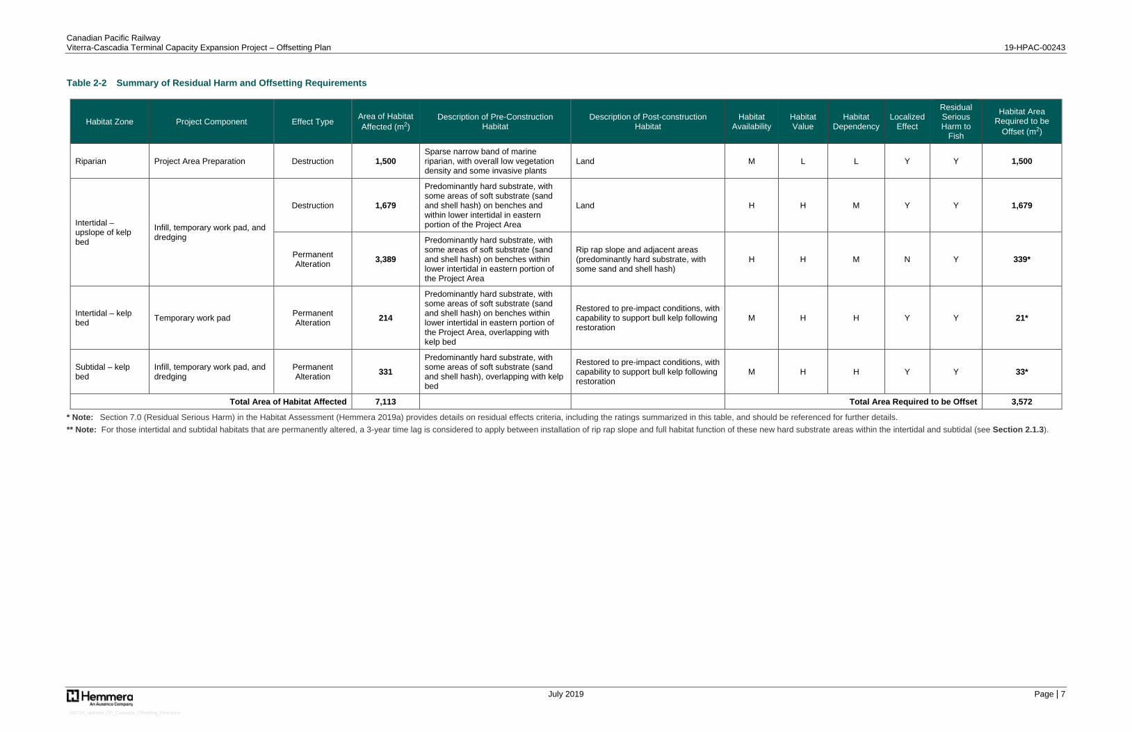
A summary of Project components, the anticipated destruction and permanent alteration of fish habitat, and the corresponding need for offsetting are provided in Table 2-2.
For those intertidal and subtidal habitats that are permanently altered, a 3-year time lag is considered to apply between installation of rip rap slope and full habitat function of these new hard substrate areas within the intertidal and subtidal. Based on time lag (and uncertainty) calculations discussed later in this Offsetting Plan to account for the delay between construction of offsetting habitats (i.e., artificial reef habitats) and their full habitat function (see Section 5.3.3), this 3-year delay is considered to require offsetting at a proportional amount of 1:10 (required offsetting: constructed habitat).
Canadian Pacific Railway Viterra-Cascadia Terminal Capacity Expansion Project – Offsetting Plan 19-HPAC-00243
July 2019 Page | 7
190724_updated_CP_Cascadia_Offsetting_Final.docx
Table 2-2 Summary of Residual Harm and Offsetting Requirements
Habitat Zone Project Component Effect Type Area of Habitat Affected (m2)
Description of Pre-Construction Habitat
Description of Post-construction Habitat
Habitat Availability
Habitat Value
Habitat Dependency
Localized Effect
Residual Serious Harm to
Fish
Habitat Area Required to be
Offset (m2)
Riparian Project Area Preparation Destruction 1,500 Sparse narrow band of marine riparian, with overall low vegetation density and some invasive plants
Land M L L Y Y 1,500
Intertidal – upslope of kelp bed
Infill, temporary work pad, and dredging
Destruction 1,679
Predominantly hard substrate, with some areas of soft substrate (sand and shell hash) on benches and within lower intertidal in eastern portion of the Project Area
Land H H M Y Y 1,679
Permanent Alteration 3,389
Predominantly hard substrate, with some areas of soft substrate (sand and shell hash) on benches within lower intertidal in eastern portion of the Project Area
Rip rap slope and adjacent areas (predominantly hard substrate, with some sand and shell hash)
H H M N Y 339*
Intertidal – kelp bed Temporary work pad Permanent
Alteration 214
Predominantly hard substrate, with some areas of soft substrate (sand and shell hash) on benches within lower intertidal in eastern portion of the Project Area, overlapping with kelp bed
Restored to pre-impact conditions, with capability to support bull kelp following restoration
M H H Y Y 21*
Subtidal – kelp bed
Infill, temporary work pad, and dredging
Permanent Alteration 331
Predominantly hard substrate, with some areas of soft substrate (sand and shell hash), overlapping with kelp bed
Restored to pre-impact conditions, with capability to support bull kelp following restoration
M H H Y Y 33*
Total Area of Habitat Affected 7,113 Total Area Required to be Offset 3,572
* Note: Section 7.0 (Residual Serious Harm) in the Habitat Assessment (Hemmera 2019a) provides details on residual effects criteria, including the ratings summarized in this table, and should be referenced for further details. ** Note: For those intertidal and subtidal habitats that are permanently altered, a 3-year time lag is considered to apply between installation of rip rap slope and full habitat function of these new hard substrate areas within the intertidal and subtidal (see Section 2.1.3).
Canadian Pacific Railway Viterra-Cascadia Terminal Capacity Expansion Project – Offsetting Plan 19-HPAC-00243
July 2019 Page | 8
190724_updated_CP_Cascadia_Offsetting_Final.docx
2.2 Summary of Residual Harm
Under the Fisheries Act, proponents are responsible for avoiding and mitigating serious harm to fish that are part of or support CRA fisheries:
35. (1) No person shall carry on any work, undertaking or activity that results in serious harm to fish that are part of a commercial, recreational, or Aboriginal fishery, or to fish that support such a fishery.
Serious harm to fish is defined as “the death of fish or any permanent alteration to, or destruction of, fish habitat.” Only when proponents are unable to completely avoid or mitigate serious harm to fish will projects require authorization under Section 35 (2) of the Fisheries Act for the project to proceed.
The Fisheries Protection Policy Statement (DFO 2013a) interprets serious harm to fish as:
The death of a fish A permanent alteration to fish habitat of a spatial scale, duration, or intensity that limits or
diminishes the ability of fish to use such habitats as spawning grounds, or as nursey, rearing, or food supply areas, or a mitigation corridor, or any other area in order to carry out one or more of their life processes
The destruction of fish habitat of a spatial scale, duration, or intensity that fish can no longer reply upon such habitats for use as spawning grounds, or as nursery, rearing, or food supply areas, or as a migration corridor, or any other area in order to carry out one of more of their life processes
After incorporation of measures to avoid and mitigate serious harm to fish that are part of a CRA fishery, or fish that support such a fishery, it is expected that some works, undertakings, and activities required by the Project will result in the permanent alteration or destruction of habitat that support CRA species.
As referenced in Table 2-2, approximately 3,934 m2 of marine aquatic (primarily intertidal) habitat will be permanently altered by Project works, undertakings and activities. As this intertidal and subtidal habitat is expected to recovery quickly, with the rip rap slope becoming colonized by sessile invertebrates and macroalgae over a short time period (i.e., 3 years), only limited offsetting for this habitat is considered to be required (i.e., offsetting for 393 m2 of marine aquatic habitat (mostly intertidal), based on offsetting at a proportional amount of 1:10 or 3,934 m2 x 0.1). This anticipated timeline for recovery applies to both areas overlapping with and located upslope of the kelp bed.
As detailed in Table 2-2, approximately 3,179 m2 of riparian and intertidal habitat will be destroyed by Project works, undertakings, and activities and will be converted to land by the Project for tracking widening purposes.
This residual serious harm will require offsetting (presented below) as part of an FAA under Section 35(2)(b) of the Fisheries Act.
Canadian Pacific Railway Viterra-Cascadia Terminal Capacity Expansion Project – Offsetting Plan 19-HPAC-00243
July 2019 Page | 9
190724_updated_CP_Cascadia_Offsetting_Final.docx
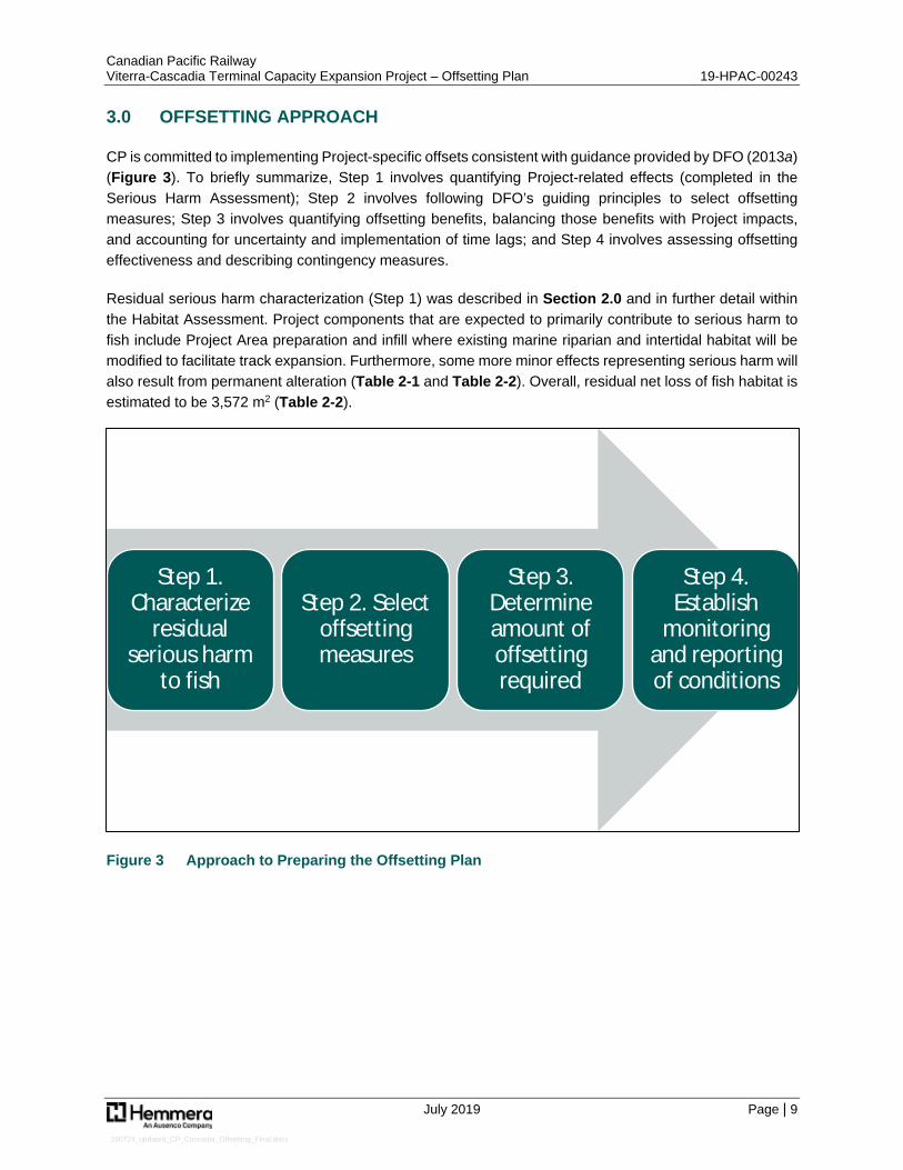
3.0 OFFSETTING APPROACH
CP is committed to implementing Project-specific offsets consistent with guidance provided by DFO (2013a) (Figure 3). To briefly summarize, Step 1 involves quantifying Project-related effects (completed in the Serious Harm Assessment); Step 2 involves following DFO’s guiding principles to select offsetting measures; Step 3 involves quantifying offsetting benefits, balancing those benefits with Project impacts, and accounting for uncertainty and implementation of time lags; and Step 4 involves assessing offsetting effectiveness and describing contingency measures.
Residual serious harm characterization (Step 1) was described in Section 2.0 and in further detail within the Habitat Assessment. Project components that are expected to primarily contribute to serious harm to fish include Project Area preparation and infill where existing marine riparian and intertidal habitat will be modified to facilitate track expansion. Furthermore, some more minor effects representing serious harm will also result from permanent alteration (Table 2-1 and Table 2-2). Overall, residual net loss of fish habitat is estimated to be 3,572 m2 (Table 2-2).
Figure 3 Approach to Preparing the Offsetting Plan
Step 1. Characterize
residual serious harm
to fish
Step 2. Select offsetting measures
Step 3. Determine amount of offsetting required
Step 4. Establish
monitoring and reporting of conditions
Canadian Pacific Railway Viterra-Cascadia Terminal Capacity Expansion Project – Offsetting Plan 19-HPAC-00243
July 2019 Page | 10
190724_updated_CP_Cascadia_Offsetting_Final.docx
4.0 SELECTION OF OFFSETTING MEASURES
4.1 Objectives
The objective of this Offsetting Plan is to maintain and enhance marine fish habitats through habitat creations consistent with DFO’s guiding principal of maintaining or enhancing the ongoing productivity and sustainability of CRA fisheries (DFO 2013a). Projects that result in residual serious harm to fish that are part of, or support, a CRA fishery, must maintain or improve the productivity of affected fisheries resources. The offsetting strategy that has guided development of this Offsetting Plan has also considered relevant fisheries management objectives and local management priorities, as described briefly below.
4.1.1 Guiding Principles for Offsetting
Offsetting measures have been selected in accordance with DFO’s stated guiding principles:
Offsetting measures must support fisheries management objectives or local restoration priorities. Benefits from offsetting measures must balance Project impacts. Offsetting measures must provide additional benefits to the fishery (i.e., benefits to the fishery must
be caused by offset actions and not by other factors). Offsetting measures must generate self-sustaining benefits over the long term that last at least as
long as the impacts from the Project (DFO 2013a).
Proposed offsetting measures will support and enhance the sustainability and ongoing productivity of CRA fisheries through the creation and enhancement of ecologically valuable habitat. DFO gives preference to in-kind measures (i.e., same quantity, quality, and habitat type) versus out-of-kind measures (i.e., differing quantity, quality, and habitat type). Further, when determining the location for offsetting, offsets that occur within the vicinity of the Project or within the same watershed are preferable (DFO 2013a). The preference is to construct offset habitats in advance of, or concurrent to, Project construction works to limit time lag between loss of habitat productivity from construction and the full functioning of offsets.
Working with CP, Hemmera took the following steps in developing this Offsetting Plan to meet the offsetting objectives and align with DFO’s guiding principles:
Determined the residual serious harm to fish or fish habitat requiring offsetting
Established criteria for selecting offsetting measures, including measures that: ▫ Are located within Burrard Inlet ▫ Will potentially support affected and local CRA fishery species ▫ Are consistent with DFO policy (DFO 2013a; 2013b) ▫ Reflect fisheries management objectives and local habitat enhancement priorities
(Section 4.2), most notably those identified by Indigenous Communities ▫ Several meetings and sessions were held with Indigenous Communities, to discuss the Project
and more specifically to receive their input on potential offsetting (Section 4.3) ▫ Are consistent with Vancouver Fraser Port Authority (VFPA) land use planning designations
and considered acceptable to VFPA, if overlapping with VFPA jurisdiction ▫ A meeting was held with VFPA Real Estate to discuss potential offsetting and ensure
compatibility with VFPA objectives and operations (Section 4.4)
Canadian Pacific Railway Viterra-Cascadia Terminal Capacity Expansion Project – Offsetting Plan 19-HPAC-00243
July 2019 Page | 11
190724_updated_CP_Cascadia_Offsetting_Final.docx
Determined the amount of offsetting required, by estimating the: ▫ Productivity of both the habitat affected by the Project and proposed offsetting habitats, based
on productivity of similar habitat estimated through on-site observations, and based on review of scientific literature and technical reports
▫ Relative values of affected and potential offset habitat types, while also considering the estimated time lag between the harm occurring and the offset becoming fully functional, uncertainty, and underlying habitat values associated with offsetting measures
Determined local habitat creation and enhancement opportunities that could be appropriate for offsetting
4.2 Fisheries Management Objectives and Local Management Priorities
Fisheries management objectives specific to the Project area were considered where available and appropriate. The resources, plans, and strategies consulted were as follows:
The Southern Pacific Salmon Integrated Fisheries Management Plan (DFO 2012) outlines fishery management objectives for stocks of concern along the BC coast between Cape Caution and the Washington border
DFO’s (2018) management goals and objectives for invertebrate fisheries are: ▫ To ensure conservation and protection of invertebrate stocks and their habitat through the
application of scientific management principles applied in a risk-averse and precautionary manner based on the best scientific advice available
▫ To meet the federal Crown’s obligations regarding Aboriginal fisheries for food, social, and ceremonial purposes
▫ To develop sustainable fisheries through partnership and co-management arrangements with client groups and stakeholders to share in decision making, responsibilities, costs, and benefits
▫ To develop fishing plans and co-operative research programs which will contribute to improving the knowledge base and understanding of the resource
▫ To consider the goals of stakeholders with respect to social, cultural, and economic value of the fishery
▫ To consider health and safety in the development and implementation of management plans and fishery openings and closures
▫ To consider opportunity for the development of the aquaculture industry ▫ To provide opportunities for a recreational fishery
Priorities identified in the Burrard Inlet Action Plan (KWL 2017): ▫ Conserve critical nearshore habitat complexes (e.g., “habitat islands” for rearing salmon, forage
fish, and other marine biota) ▫ Mapping and recovery of nearshore bull kelp beds ▫ “Net environmental gain” / “like-for-like” offsetting focus
4.3 Meetings and Sessions with Indigenous Communities
In order to gain input from Indigenous Communities and provide opportunities for identification of any additional fisheries management objectives or goals, CP and Hemmera met with those Indigenous Communities with traditional territories and interests overlapping the Project Area. Meetings to introduce the Project were pursued in advance of the preparing any offsetting concepts (March 2019), following by offsetting consultation sessions during the months of May and June, 2019. Project introduction meetings were held with the Kwikwetlem First Nation (KFN) on March 8, 2019 and the Tsleil-Waututh Nation (TWN)
Canadian Pacific Railway Viterra-Cascadia Terminal Capacity Expansion Project – Offsetting Plan 19-HPAC-00243
July 2019 Page | 12
190724_updated_CP_Cascadia_Offsetting_Final.docx
on April 26, 2019. In addition, offsetting consultation sessions to discuss the Project and potential offsetting opportunities were undertaken with the TWN on April 26, 2019 and the KFN on May 1, 2019. As of the current date, an offsetting consultation session with the Musqueam Indian Band is still pending.
Both the TWN and KFN have indicated general support for the proposed offsetting, with the understanding that the Offsetting Plan will be provided as a draft for further input. Furthermore, some additional input of note was provided by the TWN and KFN through these sessions including:
· TWN input during April 26, 2019 session:
▫ Pacific herring spawn recently observed in the Glacier Falls area of Indian Arm (April, 2019) and opportunities to provide spawning habitat values for herring should be considered in offsetting design
▫ Incorporate soft engineering approach whenever feasible (e.g., beaches) · KFN input during May 1, 2019 session:
▫ Incorporate design consideration to promote potential future use by spawning Pacific herring (e.g., appropriate consideration of substrates and tidal heights)
▫ Include research component in offsetting to inform general knowledge and benefit future management decisions (e.g., deployment of underwater cameras to record colonization and fish presence)
It is understood that additional input from Indigenous Communities may be provided as follow-up to review of the Offsetting Plan and also during further consultation undertaken by CP or DFO prior to or during the FAA application review process.
4.4 Project Offsetting Meeting with VFPA
Further to a pre-application meeting with CP, Hemmera, and VFPA that was held on February 21, 2019, CP met with VFPA Real Estate staff on April 25, 2019 to discuss potential on-site offsetting options and opportunities. As a result of this meeting, it was determined that potential offsetting was compatible with VFPA land use planning designations and should be acceptable from a marine navigation perspective. As a result of these advanced discussions with VFPA, it is noted that VFPA is supportive of the proposed offsetting features and location.
4.5 Project Information Meeting with DFO Assessor
CP and Hemmera met with Vance Mercer (DFO) on May 10, 2019 to further discuss the project. Key meeting objectives were to:
Provide DFO with a project update Review anticipated fish/fish habitat effects, and discuss the proposed offsetting balance and
approach Review the approach taken with respect to consultation and engagement with the interested
Indigenous Communities and the VFPA
The outcomes of the meeting were:
The manner in which impact calculations, offsetting requirements, and the habitat balance are being calculated appear to be generally consistent with standard practices (with the understanding that DFO still needs to undertake detailed review of the application).
Canadian Pacific Railway Viterra-Cascadia Terminal Capacity Expansion Project – Offsetting Plan 19-HPAC-00243
July 2019 Page | 13
190724_updated_CP_Cascadia_Offsetting_Final.docx
Artificial reefs pursued on-site generally appears to be a favourable offsetting approach that has a high likelihood of success and low risk of failure.
Thorough rationales for the specific relative habitat values that are being applied for this Project needs to be provided to DFO within the Offsetting Plan, for their consideration.
A 5-year monitoring period (years 1, 2, 3 and 5) is typically considered appropriate for offsetting works of the type proposed.
The amount required for the Letter of Credit can be determined once the offsetting approach has been agreed to by DFO.
4.6 Reconnaissance-Level Field Review with DFO Assessor
As described in the Habitat Assessment, a reconnaissance-level field review of the Project Area was conducted by CP (Chris Dane) and DFO staff (Vance Mercer and Sara Jossul) by boat on June 28, 2019. Although the TWN mapping in 2017 identified a “kelp line” within the shallow subtidal zone extending along the length of the Project Area, bull kelp observed by CP and DFO staff on June 28, 2019, was denser and occurred in a more continuous band than previously anticipated.
These observations suggested that some habitat areas within the Project Area are providing suitable attachment locations and productive habitat for bull kelp. It was therefore determined that a follow-up bull kelp survey was warranted to ensure proper characterization of Project effects, fish habitat impacts, and required offsetting needs. As described in the Habitat Assessment (Hemmera 2019a), results from bull kelp surveys on July 5 and 12, 2019 were used to update this Offsetting Plan to ensure the maximum possible benefit from proposed offsetting measures.
4.7 Proposed Offsetting Measures
Offsetting through habitat creation will counterbalance the residual serious harm to marine fish habitats used for life dependent processes by fish that are part of, or support, CRA fisheries. Proposed offsetting measures are designed to offset Project-related residual serious harm to riparian and predominantly hard substrate dominated intertidal and subtidal habitats in Burrard Inlet that are used by juvenile salmonids, Dungeness crab, red rock crab, forage fish and other species during sensitive life history stages.
Implementation of sufficient on-site offsetting measures is considered appropriate and of notable benefit, given proximity to the narrows where strong tidal currents provide for productive and well-flushed foreshore habitats within a central location in the inlet. Existing hard substrate habitats within the Project Area have existing values and already support a biological community of algae, invertebrates, and fish, including several species (Hemmera 2019a), including a productive bull kelp bed.
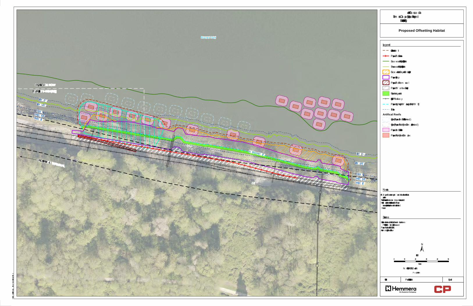
The proposed offsetting site is essentially located at the Project Area (i.e., near-site or on-site, depending upon how it is defined) and will provide out-of-kind offsetting through marine riparian planting and creation of a complex of shallow rock reefs, both near the base of the proposed infill where construction disturbance will occur and slightly offshore within shallow subtidal areas located outside the existing bull kelp bed (Figure 5). Marine aquatic offsetting features are expected to be constructed concurrent with Project construction, while marine riparian planting will occur after construction is complete.
The proposed shallow rock reefs will be predominantly constructed within areas of existing intertidal and subtidal hard substrates, with some soft sediment benches (i.e., sand and/or shell hash). Approximately
Canadian Pacific Railway Viterra-Cascadia Terminal Capacity Expansion Project – Offsetting Plan 19-HPAC-00243
July 2019 Page | 14
190724_updated_CP_Cascadia_Offsetting_Final.docx
35% of this area overlaps with proposed dredging and the temporary work pad. With exception of the temporary work pad footprint, none of the proposed reef locations overlap with the kelp bed areas. As the temporary work pad will result in permanent alteration and require restoration, it has been selected as a primary location for rock reef creation in order to enhance kelp bed habitat values and adjacent intertidal areas. Other rock reefs proposed for establishment in the intertidal, within areas upslope (shoreward) of the kelp bed are intentionally located within areas dominated by more bedrock than scattered cobble/boulder or alternatively that will be disturbed by proposed dredging. Furthermore, a cluster of rock reefs is proposed for establishment within depths of -4 to -5 m chart datum (CD) on the seaward side of the kelp bed to provide for expansion of the existing bed.
Providing an on-site structured habitat of coarse rocky substrate (i.e., boulder and cobble) within shallow depths, ranging from approximately -5 m to + 3 m CD, is expected to enhance local fish habitat by providing more productive intertidal habitat and providing for the establishment of canopy forming kelps and understory kelps in the subtidal. Replacement of existing hard substrate areas consisting of bedrock outcrops and scattered boulder/cobble substrates with large boulders, will result in a substantial improvement in habitat heterogeneity within the local setting. Establishment of rock reefs within depths of -1.5 m to +0.5 m CD in the area of overlap with the temporary work pad will provide for enhancement of this disturbed area within the existing bull kelp bed. Rock reef creation on the seaward side of the existing bull kelp bed will provide for expansion of the bed. This habitat will subsequently support early life-stages of nearshore CRA fish community species including rock fish, ling cod, surf perch, forage fish, and juvenile salmonids.
Canopy forming and understory kelp beds enhance shallow rock reef ecosystems with their physical structure, biomass, and associated organisms (Steneck et al. 2002). Kelp beds provide three-dimensional structural habitat (Steneck et al. 2002), reduce local current velocities, and dampen waves (Gaylord et al. 2007), and their canopies reduce irradiance at depth, thereby affecting understorey conditions and species assemblages (Santelices and Ojeda 1984). Kelp is eaten directly by organisms (Bustamante et al. 1995) and provides foraging habitat for kelp-associated fishes (Reisewitz et al. 2006, Norderhaug and Christie 2011). Hard, rocky substrates also provide suitable habitat for encrusting algaes including Hildenbrandia spp., Clathromorphum spp., Lithothamnion spp., Melobesia spp., and Mesophyllum spp., which are eaten directly by a number of invertebrate species including chitons and limpets.
4.7.1 Alignment with Guiding Principles
Hemmera’s proposed offsetting measures have been designed to align closely with DFO’s (2013c) stated guiding principles, which were summarized above in Section 4.1.1 and are further detailed below:
Offsetting measures must support fisheries management objectives or local restoration priorities.
Although none of the guiding principles specifically pertains to Burrard Inlet, enhancement of nearshore fish habitat broadly supports the habitat-related actions specific to the maintenance of Pacific salmon supported by key tributaries to the inlet including (but not limited to) the Indian River and Seymour River. Key salmon species that utilize the inlet as a migration corridor and for rearing habitat purposes includes chinook (Oncorhynchus tshawystscha); coho (O. kisutch); chum (O. keta); and pink (O. gorbuscha). The proposed offsetting habitat will provide abundant rearing habitat for juvenile CRA invertebrates including red rock crab (Cancer productus) and Dungeness crab (Metacarcinus magister), in alignment with DFO’s goal to ensure conservation and protection of invertebrate stocks. The proposed offsetting measures are very
Canadian Pacific Railway Viterra-Cascadia Terminal Capacity Expansion Project – Offsetting Plan 19-HPAC-00243
July 2019 Page | 15
190724_updated_CP_Cascadia_Offsetting_Final.docx
much aligned with priorities identified in the Burrard Inlet Action Plan (KWL 2017), as the proposed shallow rock reefs are expected to assist in the recovery of nearshore bull kelp habitats and will build upon existing critical nearshore habitat complexes (i.e., existing macroalgae beds and bull kelp habitat).
As follow-up to offsetting consultation sessions conducted with Aboriginal Groups and the TWN request to incorporate soft shoreline treatments (e.g., fine sediments/beach habitats) in the proposed shoreline treatment, further consideration has been provided but it has been determined that strong tidal currents will likely preclude the accretion and/or persistence of finer substrate classes.
Regarding additional recommendations from TWN and KFN to ensure that habitat offsetting properly incorporates considerations for Pacific herring, further consideration has been applied towards additional design parameters that might further enhance potential spawning habitat values for this species. Spawning grounds of Pacific herring are typically in sheltered inlets, sounds, bays and estuaries rather than along open coastlines (Haegele and Schweigert 1985). During spawning, male Pacific herring broadcast milt in the nearshore and females lay adhesive eggs on a variety of nearshore and intertidal substrates with macrophytes being particularly important including macroalgae (kelp) and seagrasses (Haegele and Schweigert 1985). Spawning can occur from high tide to depths of approximately -11 m (Hart 1973). Most (80%) of the spawn deposition occurs at depths shallower than -1.5 m chart datum (Hourston and Haegele 1980).
Recent studies suggest that depth is positively related to herring egg loss with shallower depths resulting in higher egg loss rates. Benthic predation and habitat type are strong drivers of egg survivorship and a high proportion of eggs are consumed by predators (e.g., seastars) especially when spawned on benthic substrates. (Keeling et al. 2017). With human development along marine shoreline areas, herring have also been documented spawning on creosote-treated pilings and other anthropogenic substrates (Palsson 1984). In an effort to increase survival of herring spawn in upper Howe Sound and False Creek, stewardship groups have wrapped creosote-treated pilings with weed control fabric (Coastal Ocean Research Institute 2017). These efforts to separate eggs from creosote-contaminated surfaces have been successful, but it is still evident that herring prefer natural habitats and spawning substrates and greater egg survivorship occurs when eggs are deposited on macrophytes.
It is anticipated that lower intertidal portions of the Project fill slope and, to a greater degree, the proposed shallow artificial reefs will provide stable hard substrates and support macroalgae within an appropriate tidal range to encourage herring spawning. These reefs will be installed in an arrangement that is expected to provide complexity and heterogeneity with potential value for spawning herring. Strong tidal currents at this location may also represent an underlying constraint on potential spawning values for herring. Even if supplemental design considerations were warranted, it appears likely there would still be other more quiescent areas within the inlet that will continue to provide more suitable spawning habitat. Regardless, it is anticipated that the proposed shallow rock reefs will provide a net improvement in habitat values for forage fish species.
Benefits from offsetting measures must balance Project impacts.
The predicted benefits from the offsetting measures are anticipated to balance the Project impacts on CRA fisheries and fish habitat supporting those fisheries through the creation of high-value rearing, spawning, and foraging habitat for numerous CRA species that may be impacted by the Project, including various Pacific salmon species, red rock crab, and Dungeness crab.
Offsetting measures must provide additional benefits to the fishery (i.e., benefits to the fishery are caused by offset actions and not by other factors).
Canadian Pacific Railway Viterra-Cascadia Terminal Capacity Expansion Project – Offsetting Plan 19-HPAC-00243
July 2019 Page | 16
190724_updated_CP_Cascadia_Offsetting_Final.docx
In addition to primary production from the macroalgae and kelp (potentially including bull kelp) species, which the reefs are expected to support, the proposed offsetting habitat is anticipated to provide additional benefit to CRA fisheries and fish habitat. Of note, these reefs will support those fisheries through the creation of high-value rearing, spawning, and foraging habitat for a number of CRA species that may be impacted by the Project, including various Pacific salmon species, red rock crab, and Dungeness crab.
Offsetting measures must generate self-sustaining benefits over the long-term that last at least as long as the impacts from the Project.
The design and location of the proposed offsetting habitat measures have been selected to ensure the habitat remains productive over the life of the Project. The depth range of the shallow rock reefs has been selected to accommodate up to several metres of sea level rise without a significant change in light availability. Additionally, the reefs are anticipated to seasonally recruit a diverse kelp canopy and benthic algal understory in perpetuity.
4.7.2 Riparian Planting Plan
Riparian plantings will be undertaken in the spring of 2020 to restore riparian habitat values along the length of the Project Area and in proximity to marine aquatic habitats. Project Area conditions and close proximity to Burrard Inlet requires consideration to ensure the success of riparian plantings over the long-term.
Proposed riparian plants will include a variety of native tree and shrub species in the newly established riparian zone created by placement of rock fill materials, which are characteristic of those species already found on-site or anticipated to thrive within Project Area conditions following soil placement.
Approximately 25 to 50 m3 of topsoil will be applied over the proposed planting area to facilitate plant growth. Topsoil will be actively worked into the interstices of the rocks to provide suitable micro habitats for planting that contain sufficient soil moisture and nutrients. Shrubs will be preferentially installed in these micro-sites. Trees will be installed into native soil material in suitable locations above the riprap material or in areas where >50 cm of topsoil material is present.
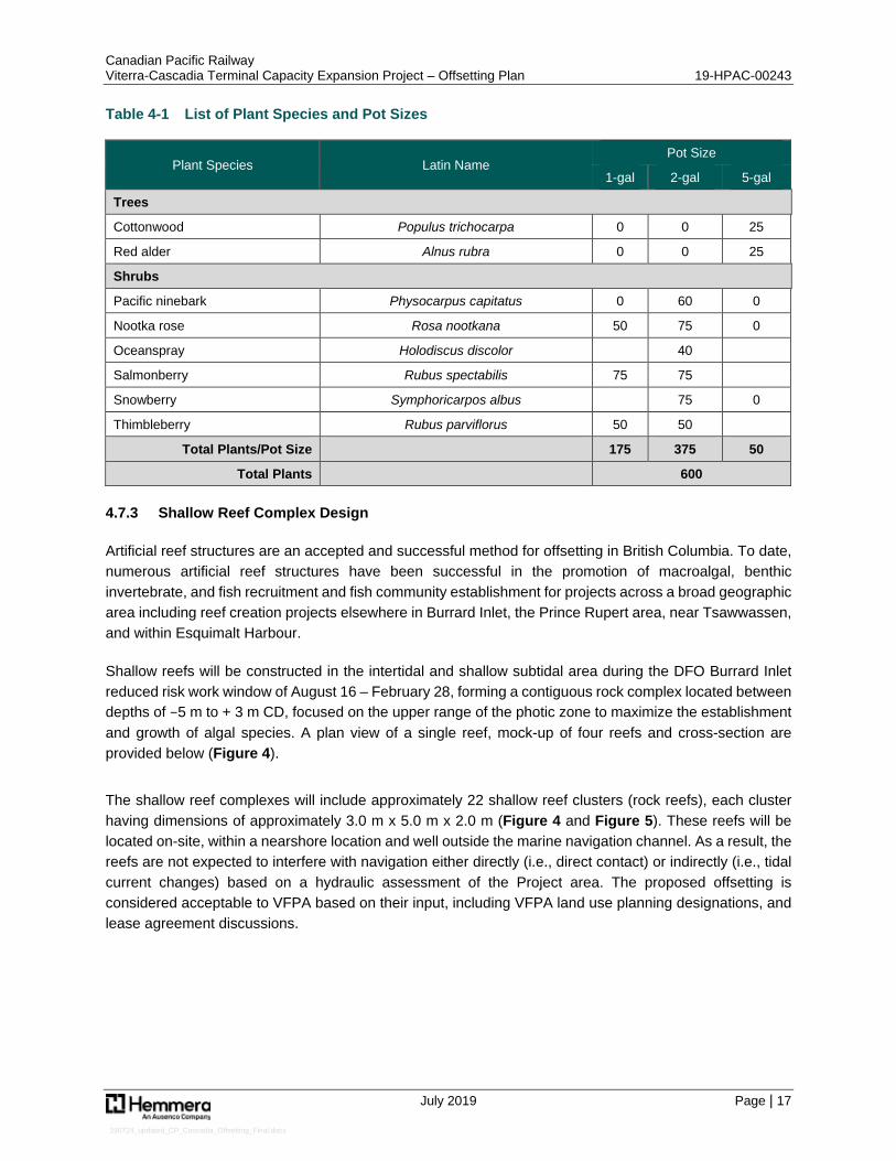
Based on a proposed planting density of 1 metre centre-to-centre spacing and a minimum distance of 5 m between any trees, a total of 600 native shrubs and trees are proposed Table 4-1. Over 2/3 of the rooted plants to be installed will be 2-gal or 5-gal size, which require more space per individual than would be expected for plugs or 1-gal pots. Although pot sizes listed in Table 4-1 are preferred, they may need to be varied slightly depending on the plant stock availability at time of purchase.
The entire area proposed for revegetation will also be broadcast seeded with Coast Restoration grass seed mixture and will be covered with straw that is worked into the topsoil to help minimize topsoil erosion.
Canadian Pacific Railway Viterra-Cascadia Terminal Capacity Expansion Project – Offsetting Plan 19-HPAC-00243
July 2019 Page | 17
190724_updated_CP_Cascadia_Offsetting_Final.docx
Table 4-1 List of Plant Species and Pot Sizes
Plant Species Latin Name Pot Size
1-gal 2-gal 5-gal
Trees
Cottonwood Populus trichocarpa 0 0 25
Red alder Alnus rubra 0 0 25
Shrubs
Pacific ninebark Physocarpus capitatus 0 60 0
Nootka rose Rosa nootkana 50 75 0
Oceanspray Holodiscus discolor 40
Salmonberry Rubus spectabilis 75 75
Snowberry Symphoricarpos albus 75 0
Thimbleberry Rubus parviflorus 50 50
Total Plants/Pot Size 175 375 50
Total Plants 600
4.7.3 Shallow Reef Complex Design
Artificial reef structures are an accepted and successful method for offsetting in British Columbia. To date, numerous artificial reef structures have been successful in the promotion of macroalgal, benthic invertebrate, and fish recruitment and fish community establishment for projects across a broad geographic area including reef creation projects elsewhere in Burrard Inlet, the Prince Rupert area, near Tsawwassen, and within Esquimalt Harbour.
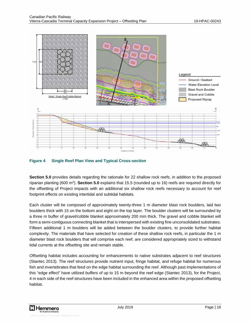
Shallow reefs will be constructed in the intertidal and shallow subtidal area during the DFO Burrard Inlet reduced risk work window of August 16 – February 28, forming a contiguous rock complex located between depths of −5 m to + 3 m CD, focused on the upper range of the photic zone to maximize the establishment and growth of algal species. A plan view of a single reef, mock-up of four reefs and cross-section are provided below (Figure 4).
The shallow reef complexes will include approximately 22 shallow reef clusters (rock reefs), each cluster having dimensions of approximately 3.0 m x 5.0 m x 2.0 m (Figure 4 and Figure 5). These reefs will be located on-site, within a nearshore location and well outside the marine navigation channel. As a result, the reefs are not expected to interfere with navigation either directly (i.e., direct contact) or indirectly (i.e., tidal current changes) based on a hydraulic assessment of the Project area. The proposed offsetting is considered acceptable to VFPA based on their input, including VFPA land use planning designations, and lease agreement discussions.
Canadian Pacific Railway Viterra-Cascadia Terminal Capacity Expansion Project – Offsetting Plan 19-HPAC-00243
July 2019 Page | 18
190724_updated_CP_Cascadia_Offsetting_Final.docx
Figure 4 Single Reef Plan View and Typical Cross-section
Section 5.0 provides details regarding the rationale for 22 shallow rock reefs, in addition to the proposed riparian planting (600 m2). Section 5.0 explains that 15.5 (rounded up to 16) reefs are required directly for the offsetting of Project impacts with an additional six shallow rock reefs necessary to account for reef footprint effects on existing intertidal and subtidal habitats.
Each cluster will be composed of approximately twenty-three 1 m diameter blast rock boulders, laid two boulders thick with 15 on the bottom and eight on the top layer. The boulder clusters will be surrounded by a three m buffer of gravel/cobble blanket approximately 200 mm thick. The gravel and cobble blanket will form a semi-contiguous connecting blanket that is interspersed with existing fine unconsolidated substrates. Fifteen additional 1 m boulders will be added between the boulder clusters, to provide further habitat complexity. The materials that have selected for creation of these shallow rock reefs, in particular the 1 m diameter blast rock boulders that will comprise each reef, are considered appropriately sized to withstand tidal currents at the offsetting site and remain stable.
Offsetting habitat includes accounting for enhancements to native substrates adjacent to reef structures (Stantec 2013). The reef structures provide nutrient input, fringe habitat, and refuge habitat for numerous fish and invertebrates that feed on the edge habitat surrounding the reef. Although past implementations of this “edge effect” have utilized buffers of up to 15 m beyond the reef edge (Stantec 2013), for the Project, 4 m each side of the reef structures have been included in the enhanced area within the proposed offsetting habitat.
Canadian Pacific Railway Viterra-Cascadia Terminal Capacity Expansion Project – Offsetting Plan 19-HPAC-00243
July 2019 Page | 19
190724_updated_CP_Cascadia_Offsetting_Final.docx
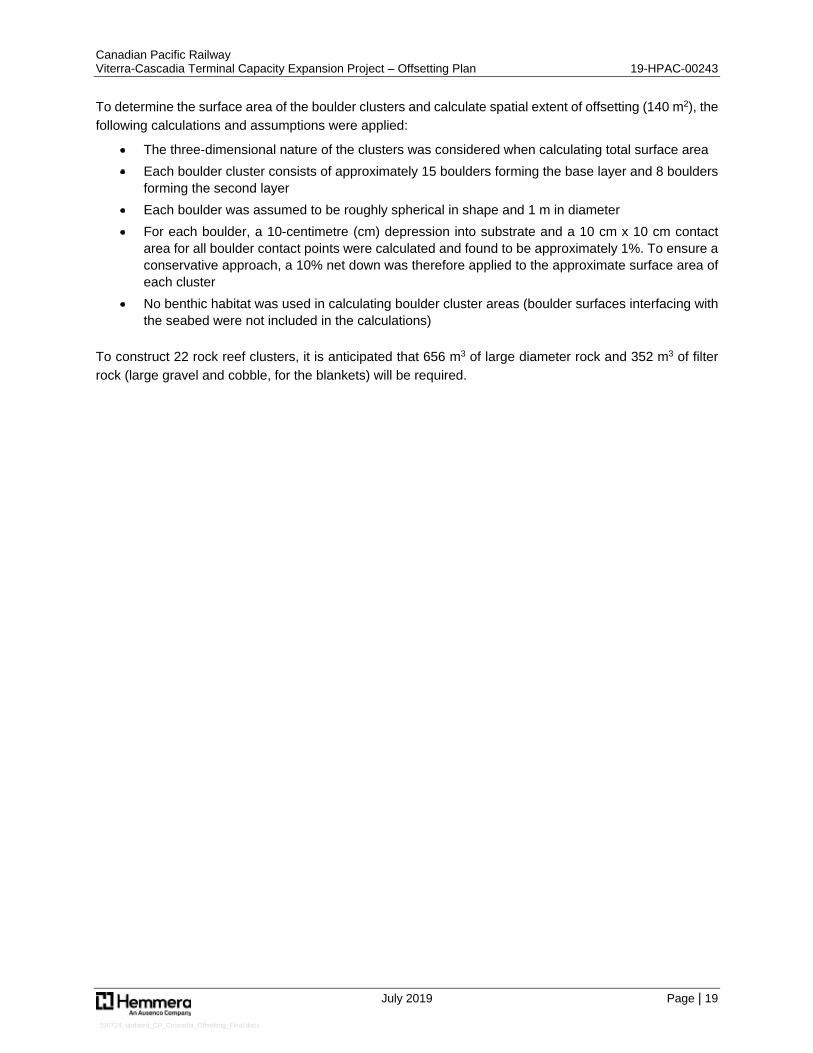
To determine the surface area of the boulder clusters and calculate spatial extent of offsetting (140 m2), the following calculations and assumptions were applied:
The three-dimensional nature of the clusters was considered when calculating total surface area Each boulder cluster consists of approximately 15 boulders forming the base layer and 8 boulders
forming the second layer Each boulder was assumed to be roughly spherical in shape and 1 m in diameter For each boulder, a 10-centimetre (cm) depression into substrate and a 10 cm x 10 cm contact
area for all boulder contact points were calculated and found to be approximately 1%. To ensure a conservative approach, a 10% net down was therefore applied to the approximate surface area of each cluster
No benthic habitat was used in calculating boulder cluster areas (boulder surfaces interfacing with the seabed were not included in the calculations)
To construct 22 rock reef clusters, it is anticipated that 656 m3 of large diameter rock and 352 m3 of filter rock (large gravel and cobble, for the blankets) will be required.
Path: S:\Geomatics\Projects\103396\02\mxd\Fig5__103396_02_ProposedOffsettingHabitat_190724.mxd
P roduction Da te: Jul 24, 2019
P a ge Size: 11" x 17"
103396-02
N AD 1983 CSRS UTM Z one 10N
Burrard Inlet
N EW HHW LT
LLW MTMW LHHW MT
LLW LT
HHW LT
HHW LT
LLW LT
HHW MTMW L
LLW MTCASCADIA TERMIN AL
CP LEASE ROW
[P LAN V-4324(02)]
Viterra -Ca sca dia Term ina l Ca pa city Expa nsion P roject
Burra rd Inlet, Burna by, BC
Legend
±1:1,000
0 10 20 30 40 50Metres
Construction Z one Lim itP roposed Tra ck ExtensionSea wa rd Kelp Bed Extent (2019)Shorewa rd Kelp Bed Extent (2019)Exca va tion Area Beyond Gra ding StructureP roposed Ripra pP roposed Tra ck Rem ova lP roposed W a lkwa y for TurnoutRipa ria n Vegeta tionExisting CP Ra ilwa yP roposed Higher High W a ter La rge Tide (HHW LT)Tide Line
Artifical ReefsOrigina lly P roposed 3m Buffer of Cobble (Archived)Origina lly P roposed Rocky Reef Com plex (Archived)P roposed 3m Buffer of CobbleP roposed Rocky Reef Com plex
- Conta ins inform a tion licensed under the Open Governm ent Licences -P rovince of British Colum bia a nd City of Va ncouver- P roposed P roject Fea tures: AECOM, 2019- Aeria l Im a ge: City of Va ncouver, 2015
Sources
1. All m a pped fea tures a re a pproxim a te a nd should be used for discussionpurposes only.2. This m a p is not intended to be a “sta nd-a lone” docum ent, but a visua l a idof the inform a tion conta ined within the referenced Report. It is intended tobe used in conjunction with the scope of services a nd lim ita tions describedtherein.
N otes
Figure 5
Proposed Offsetting Habitat
Canadian Pacific Railway Viterra-Cascadia Terminal Capacity Expansion Project – Offsetting Plan 19-HPAC-00243
July 2019 Page | 21
190724_updated_CP_Cascadia_Offsetting_Final.docx
5.0 AMOUNT OF OFFSETTING REQUIRED
This section provides a summary of the rationale used to determine Project-related offsetting requirements, based on affected habitats at the Project Area and the proposed offsetting, including conceptual offsetting designs described below.
5.1 Relative Habitat Productivity Values
Quantification of the ongoing productivity of fish habitat is commonly difficult to estimate with confidence; therefore, habitat losses and gains are typically expressed as a measure of habitat area and habitat type. However, fish productivity across ecosystems is determined not only by the usable area (i.e., quantity), but also by the quality and productivity of available habitat. In addition to the amount of space available for use by aquatic organisms, the ongoing productivity of fish and fish habitat is influenced by a number of physical and biological features, including habitat complexity, species diversity, primary production, prey availability, availability of refuge from predators, and environmental conditions (e.g., submergence, water flow, disturbance regimes, temperature, dissolved oxygen, pH).
The Fisheries Productivity Investment Policy (FPIP) (DFO 2013a) also identifies that “out-of-kind” offsetting requires a more complex approach. For this proposed Offsetting Plan, marine riparian losses will be offset with some limited riparian plantings and artificial reef construction while marine aquatic (primarily intertidal) losses will be offset with artificial reefs. Although the use of “out-of-kind” offsetting for this Project is limited to the use of shallow rock reef habitat to offset a minor amount of residual riparian habitat destruction, equivalency metrics are still required to provide a comparison of relative value of habitats and can be used to determine the amount of offsetting required to achieve an equitable balance between project impacts and offsetting gains (Bradford 2017).
To determine the amount of habitat required to offset residual serious harm to fish for this Project, a relative productivity approach within a habitat equivalency framework is proposed for assessing the relative value of habitats lost by Project construction and gained from proposed riparian plantings and establishment of artificial reefs on-site.
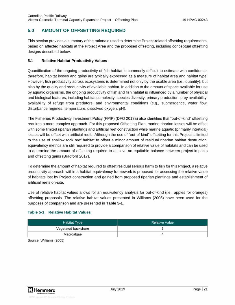
Use of relative habitat values allows for an equivalency analysis for out-of-kind (i.e., apples for oranges) offsetting proposals. The relative habitat values presented in Williams (2005) have been used for the purposes of comparison and are presented in Table 5-1.
Table 5-1 Relative Habitat Values
Habitat Type Relative Value
Vegetated backshore 3 Macroalgae 4
Source: Williams (2005)
Canadian Pacific Railway Viterra-Cascadia Terminal Capacity Expansion Project – Offsetting Plan 19-HPAC-00243
July 2019 Page | 22
190724_updated_CP_Cascadia_Offsetting_Final.docx
5.2 Habitat Affected by the Project
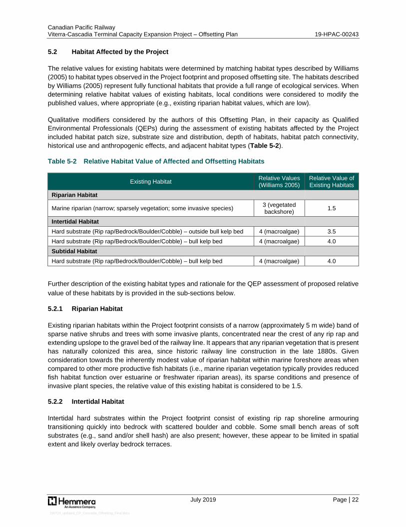
The relative values for existing habitats were determined by matching habitat types described by Williams (2005) to habitat types observed in the Project footprint and proposed offsetting site. The habitats described by Williams (2005) represent fully functional habitats that provide a full range of ecological services. When determining relative habitat values of existing habitats, local conditions were considered to modify the published values, where appropriate (e.g., existing riparian habitat values, which are low).
Qualitative modifiers considered by the authors of this Offsetting Plan, in their capacity as Qualified Environmental Professionals (QEPs) during the assessment of existing habitats affected by the Project included habitat patch size, substrate size and distribution, depth of habitats, habitat patch connectivity, historical use and anthropogenic effects, and adjacent habitat types (Table 5-2).
Table 5-2 Relative Habitat Value of Affected and Offsetting Habitats
Existing Habitat Relative Values (Williams 2005)
Relative Value of Existing Habitats
Riparian Habitat
Marine riparian (narrow; sparsely vegetation; some invasive species) 3 (vegetated backshore) 1.5
Intertidal Habitat Hard substrate (Rip rap/Bedrock/Boulder/Cobble) – outside bull kelp bed 4 (macroalgae) 3.5 Hard substrate (Rip rap/Bedrock/Boulder/Cobble) – bull kelp bed 4 (macroalgae) 4.0 Subtidal Habitat Hard substrate (Rip rap/Bedrock/Boulder/Cobble) – bull kelp bed 4 (macroalgae) 4.0
Further description of the existing habitat types and rationale for the QEP assessment of proposed relative value of these habitats by is provided in the sub-sections below.
5.2.1 Riparian Habitat
Existing riparian habitats within the Project footprint consists of a narrow (approximately 5 m wide) band of sparse native shrubs and trees with some invasive plants, concentrated near the crest of any rip rap and extending upslope to the gravel bed of the railway line. It appears that any riparian vegetation that is present has naturally colonized this area, since historic railway line construction in the late 1880s. Given consideration towards the inherently modest value of riparian habitat within marine foreshore areas when compared to other more productive fish habitats (i.e., marine riparian vegetation typically provides reduced fish habitat function over estuarine or freshwater riparian areas), its sparse conditions and presence of invasive plant species, the relative value of this existing habitat is considered to be 1.5.
5.2.2 Intertidal Habitat
Intertidal hard substrates within the Project footprint consist of existing rip rap shoreline armouring transitioning quickly into bedrock with scattered boulder and cobble. Some small bench areas of soft substrates (e.g., sand and/or shell hash) are also present; however, these appear to be limited in spatial extent and likely overlay bedrock terraces.
Canadian Pacific Railway Viterra-Cascadia Terminal Capacity Expansion Project – Offsetting Plan 19-HPAC-00243
July 2019 Page | 23
190724_updated_CP_Cascadia_Offsetting_Final.docx
Intertidal areas above +0.5 m CD do not overlap with the bull kelp bed, while areas below +0.5 m CD (i.e., 0 m to +0.5 m CD) overlap with the kelp bed. These intertidal habitats are anticipated to have a similar potential productivity to the macroalgae habitat described by Williams (2005), especially in areas of overlap with the kelp bed. The presence of some soft substrate areas and lack of extensive macroalgae coverage (including bull kelp) warrants a minor reduction in relative value of this existing habitat to 3.5 for those portions of the subtidal which do not overlap with the kelp bed.
5.2.3 Subtidal Habitat
Subtidal hard substrates within the Project footprint are similar to intertidal habitats which overlap with the bull kelp bed, consisting primarily of bedrock with scattered boulder and cobble. Also similar to the intertidal, some flatter areas characterized by soft substrates (e.g., sand and/or shell hash) are also present on bedrock benches but are overall a very minor component.
As with portions of the intertidal which overlap with the kelp bed, subtidal habitats overlap with multi-canopy macroalgae beds dominated by bull kelp and are therefore considered to have a similar potential productivity to the macroalgae habitat described by Williams (2005).
5.2.4 Proposed Offsetting Habitats –Riparian Planting and Shallow Rock Reefs
5.2.4.1 Riparian Planting
Offsetting for riparian planting will overlap with areas that were previously aquatic fish habitat (intertidal) and will converted to land through infilling. As the destruction of these areas is already fully accounted for in Table 2-2, the relative value of this habitat prior to riparian restoration is considered to be 0.
Riparian planting efforts will result in establishment of a band of native shrubs and trees along and above the higher high-water large tide. With the understanding that riparian restoration efforts will need to be fully successful and achieve resultant shrub and tree densities that are much higher than the existing riparian habitats for which a relative value of 1.5 is considered to apply, a relative value of 2.5 is expected to result. The relatively narrow width of the proposed riparian restoration area (e.g., 2 m) is the primary reason that a relative value of 3.0 (i.e., consistent with Williams, 2005) is not proposed.
5.2.4.2 Shallow rock reefs
The existing habitat values described above for the marine aquatic (intertidal and subtidal) habitats (see Sections 5.2.2 through 5.2.3) apply to the areas where artificial reefs are proposed for construction, with the understanding that approximately 35% of these areas overlap with the dredging and/or temporary work pad resulting in some alteration in advance of offsetting.
Proposed shallow reef habitat will be created overtop of existing hard substrate habitat that has an existing habitat value of 3.5 (no kelp bed overlap) to 4.0 (kelp bed overlap, to be disturbed by temporary work pad construction). High-quality shallow reef habitat is anticipated to provide similar habitat value to the macroalgae habitat described by Williams (2005) with a relative habitat value of 4. This resultant habitat value is based upon an expectation that the increased productivity with the establishment of more complex intertidal habitats with canopy forming and understory kelp communities forming within subtidal portions will support juvenile rock fish, juvenile Pacific salmon, and crabs. Habitat created through construction of these shallow reefs is expected to achieve high productivity and be fully functional within 3 years of construction.
Canadian Pacific Railway Viterra-Cascadia Terminal Capacity Expansion Project – Offsetting Plan 19-HPAC-00243
July 2019 Page | 24
190724_updated_CP_Cascadia_Offsetting_Final.docx
5.3 Offsetting Requirements
Once habitat balance ratios have been applied to determine the required habitat offset area, relative habitat values have been applied to determine the amount of habitat required to offset residual serious harm. The relative value of habitat affected by the Project and habitat proposed to offset losses were presented in Table 5-3. A comparison of relative habitat values allows the Project to replace impacted habitat with more productive habitat, achieving equivalency and counterbalancing Project-related effects. Relative habitat values used for this assessment are based on accepted relative habitat value approaches (Williams 2005) and recent field observations (Hemmera 2018). Offsetting habitat requirements (e.g., the amount of habitat required to offset residual harm) are presented in Table 5-3.
Canadian Pacific Railway Viterra-Cascadia Terminal Capacity Expansion Project – Offsetting Plan 19-HPAC-00243
July 2019 Page | 25
190724_updated_CP_Cascadia_Offsetting_Final.docx
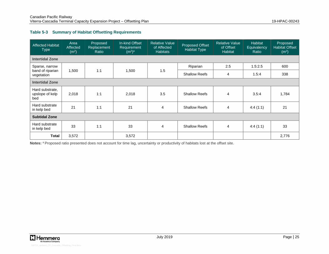
Table 5-3 Summary of Habitat Offsetting Requirements
Affected Habitat Type
Area Affected
(m2)
Proposed Replacement
Ratio
In-kind Offset Requirement
(m2)a
Relative Value of Affected Habitats
Proposed Offset Habitat Type
Relative Value of Offset Habitat
Habitat Equivalency
Ratio
Proposed Habitat Offset
(m2)
Intertidal Zone
Sparse, narrow band of riparian vegetation
1,500 1:1 1,500 1.5 Riparian 2.5 1.5:2.5 600
Shallow Reefs 4 1.5:4 338
Intertidal Zone
Hard substrate, upslope of kelp bed
2,018 1:1 2,018 3.5 Shallow Reefs 4 3.5:4 1,784
Hard substrate in kelp bed 21 1:1 21 4 Shallow Reefs 4 4:4 (1:1) 21
Subtidal Zone
Hard substrate in kelp bed 33 1:1 33 4 Shallow Reefs 4 4:4 (1:1) 33
Total 3,572 3,572 2,776
Notes: a Proposed ratio presented does not account for time lag, uncertainty or productivity of habitats lost at the offset site.
Canadian Pacific Railway Viterra-Cascadia Terminal Capacity Expansion Project – Offsetting Plan 19-HPAC-00243
July 2019 Page | 26
190724_updated_CP_Cascadia_Offsetting_Final.docx
5.3.1 Habitat Balance Summary
Hemmera proposes that affected habitat types be offset using a replacement ratio of 1:1 (offset:impact); prior to the implementation of time lag and uncertainty factors). Habitats affected by the Project, if offset using in-kind habitats, would establish quickly and with relatively little uncertainty. Generally, higher replacement ratios (e.g., 2:1) are used to replace productive habitats that require additional time to reach full function (e.g., tidal marsh) or where there is a higher uncertainty associated with their construction and development (e.g., eelgrass beds).
The use of relative habitat values provides for a comparison between habitats in the proposed out-of-kind offsetting scenario and where offsetting habitats may be substantially or only very modestly more valuable than affected habitats (e.g., shallow reefs offsetting riparian or intertidal/subtidal hard substrates, respectively).
Riparian habitats will be offset by riparian restoration (600 m2) and construction of shallow reef complexes (338 m2) at ratios of 1.5:2.5 and 1.4:4, respectively, which reflects the relatively poor habitat quality of existing riparian habitat values relative to the proposed offset habitats
Intertidal and subtidal hard substrates will be offset by shallow reef habitat (2,176 m2) at ratios of 3.5:4, reflecting a minor anticipated improvement in habitat productivity for the proposed offsetting habitat versus existing habitat conditions.
5.3.2 Accounting for Existing Habitat Values
In order to provide for proper accounting of habitat values lost and gained by the project, the footprint effects of any offsetting habitats also need to be taken into consideration. A description of the existing habitat values overlapping with the different types of offsetting habitats (riparian plantings and shallow rock reef) is provided below in Sections 5.3.2.1 and 5.3.2.2.
5.3.2.1 Riparian Plantings
Areas where riparian plantings will be undertaken are modified from original habitat and considered to have no habitat values.
5.3.2.2 Shallow Rock Reef
Existing intertidal and subtidal hard substrates will be affected by proposed establishment of 2,176 m2 of shallow reef habitat. Based on a reef surface area of approximately 140 m2 per reef (as described in Section 4.6.3), 2,176 m2 of shallow reef habitat requires construction of 15.5 reefs which would result in a total of approximately 2,170 m2 of reef habitat with installation of 10 isolated boulders more than providing for any shortfall. Since a partial reef is not easily constructed and in order to introduce further conservativeness in the habitat balance, 16 reefs are proposed to be constructed resulting in 2,240 m2 of shallow reef habitat. This equates to an additional reef area of 64 m2, which is subsequently used for calculations of reef footprint area below, along with time lag and uncertainty (Section 5.3.3).
In order to account for productivity losses that might otherwise result from footprint effects, some additional habitat will need to be created. The footprint of each reef is approximately 99 m2, including approximately 15 m2 covered with blast rock boulders and an additional approximately 84 m2 of gravel/cobble blanket. For the 16 proposed shallow reefs, the total footprint area is approximately 1,584 m2 (including 240 m2 boulder footprint and 1,344 m2 gravel/cobble blanket footprint). For the purposes of this calculation the 10 additional isolated boulders are not considered to result in a footprint effect, given their minor areal extent.
Canadian Pacific Railway Viterra-Cascadia Terminal Capacity Expansion Project – Offsetting Plan 19-HPAC-00243
July 2019 Page | 27
190724_updated_CP_Cascadia_Offsetting_Final.docx
To account for loss of approximately 240 m2 of existing intertidal and subtidal hard substrates from the combined boulder footprint and with the understanding that only 4 of 16 reefs overlap with the existing kelp bed, the existing habitat is considered to have a pro-rated relative value of 3.6:41 in comparison to the shallow reef habitat, an additional 216 m2 of reef habitat will need to be constructed.
To account for additional 1,344 m2 of intertidal and subtidal hard substrates overlapping with the gravel/cobble blanket, a 3-year time lag is considered to apply between alteration and return of full habitat function of these. Based on an anticipated 3-year time lag between construction of offsetting habitats (i.e., artificial reef habitats) and achievement of full habitat function (Section 4.3.3), this 3-year delay warrants additional offsetting. As described in Section 4.3.3, a proportional amount of 1:10 of additional offsetting is considered to be required (required offsetting: constructed habitat). This requires construction of an additional 134 m2 of reef habitat. As the gravel/cobble blanket is considered to have relative habitat values equivalent to existing conditions following this 3-year recovery period, a 1:1 relative value applies.
This results in a total shallow reef habitat target of approximately 2,240 m2 plus approximately 350 m2, for a total shallow reef habitat design (surface) area of 2,590 m2.
5.3.3 Time Lag and Uncertainty
Habitats described by Williams (2005) represent high-quality habitat that is fully functional, providing a full range of ecological services. For constructed offsetting habitats, there is typically a delay between Project construction and full habitat function.
As the riparian habitat is only a very minor component of this Offsetting Plan and riparian habitat impacts will be predominantly offset by much higher value shallow reef habitat, with only 600 m2 of riparian plantings proposed, no further multipliers are considered necessary.
To account for any time lag prior to full habitat function of the shallow reef habitat, a 3% discount rate is used in this Offsetting Plan to determine additional offsetting requirements. Furthermore, this 3% discount rate has been compounded by the number of years between construction and functioning habitat (Bradford 2017). The period of time for cleared or newly introduced rocky substrate to achieve species assemblage and abundance similar to undisturbed substrate is 3 to 4 years (Vance 1988). Construction of shallow reef habitats is scheduled concurrently with the construction of the Project, which will minimize any time lag between the loss of residual habitat associated with the Project and creation of the shallow reef habitat. The shallow reef habitat is; however, still expected to take approximately 3 years to become fully functional, as calculated using the following equation:
Mlag = (1 + r)tlag)
Mlag = Multiplier that accounts for discounted loss of habitat value due to time lag (expressed as percentage of total habitat area)
r = discount rate (3% or 0.03) tlag = Time for habitat to achieve productivity (3 years)
1 4 of 16 reefs overlap with the existing bull kelp bed (relative value: 4) and the remaining 12 overlap with other areas (relative
value: 3.5), with understanding that temporary work pad area and overlap with kelp bed is first priority for reef placement; calculation is (4/16 x 4) + (12/16 x 3.5) = 3.6.
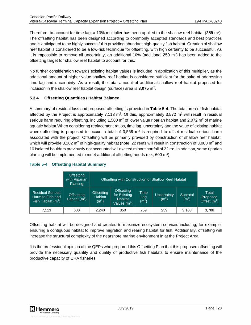
Canadian Pacific Railway Viterra-Cascadia Terminal Capacity Expansion Project – Offsetting Plan 19-HPAC-00243
July 2019 Page | 28
190724_updated_CP_Cascadia_Offsetting_Final.docx
Therefore, to account for time lag, a 10% multiplier has been applied to the shallow reef habitat (259 m2). The offsetting habitat has been designed according to commonly accepted standards and best practices and is anticipated to be highly successful in providing abundant high-quality fish habitat. Creation of shallow reef habitat is considered to be a low-risk technique for offsetting, with high certainty to be successful. As it is impossible to remove all uncertainty, an additional 10% (additional 259 m2) has been added to the offsetting target for shallow reef habitat to account for this.
No further consideration towards existing habitat values is included in application of this multiplier, as the additional amount of higher value shallow reef habitat is considered sufficient for the sake of addressing time lag and uncertainty. As a result, the total amount of additional shallow reef habitat proposed for inclusion in the shallow reef habitat design (surface) area is 3,075 m2.
5.3.4 Offsetting Quantities / Habitat Balance
A summary of residual loss and proposed offsetting is provided in Table 5-4. The total area of fish habitat affected by the Project is approximately 7,113 m2. Of this, approximately 3,572 m2 will result in residual serious harm requiring offsetting, including 1,500 m2 of lower value riparian habitat and 2,072 m2 of marine aquatic habitat.When considering replacement ratios, time lag, uncertainty and the value of existing habitat where offsetting is proposed to occur, a total of 3,568 m2 is required to offset residual serious harm associated with the project. Offsetting will be primarily provided by construction of shallow reef habitat, which will provide 3,102 m2 of high-quality habitat (note: 22 reefs will result in construction of 3,080 m2 and 10 isolated boulders previously not accounted will exceed minor shortfall of 22 m2. In addition, some riparian planting will be implemented to meet additional offsetting needs (i.e., 600 m2).
Table 5-4 Offsetting Habitat Summary
Offsetting
with Riparian Planting
Offsetting with Construction of Shallow Reef Habitat
Residual Serious Harm to Fish and Fish Habitat (m2)
Offsetting Habitat (m2)
Offsetting Habitat
(m2)
Offsetting for Existing
Habitat Values (m2)
Time Lag (m2)
Uncertainty (m2)
Subtotal (m2)
Total Proposed Offset (m2)
7,113 600 2,240 350 259 259 3,108 3,708
Offsetting habitat will be designed and created to maximize ecosystem services including, for example, ensuring a contiguous habitat to improve migration and rearing habitat for fish. Additionally, offsetting will increase the structural complexity of the nearshore marine environment in at the Project Area.
It is the professional opinion of the QEPs who prepared this Offsetting Plan that this proposed offsetting will provide the necessary quantity and quality of productive fish habitats to ensure maintenance of the productive capacity of CRA fisheries.
Canadian Pacific Railway Viterra-Cascadia Terminal Capacity Expansion Project – Offsetting Plan 19-HPAC-00243
July 2019 Page | 29
190724_updated_CP_Cascadia_Offsetting_Final.docx
6.0 OFFSETTING IMPLEMENTATION AND MONITORING
Construction of offsetting habitats has the potential to affect fish and fish habitat (similar to the Project), therefore the proposed offsetting must be constructed in such a way so as to seek to avoid and mitigate potential adverse effects. Construction of offsetting habitats will be guided by mitigation measures outlined in a Construction Environmental Management Plan (CEMP), including implementation of Best Management Practices (BMPs) and DFO’s Measures to Avoid Causing Harm to Fish and Fish Habitat (2013c).
The FPIP (DFO 2013a) outlines a hierarchy of measures and standards for fisheries protection that aim to: (1) Avoid, (2) Mitigate, and/or (3) Offset. The FPIP states that the first, and preferred measure, is to avoid Project effects. Where avoidance cannot be achieved, then mitigation measures must be implemented to minimize any serious harm to fish and fish habitat. The following mitigation options are designed to avoid and minimize potential adverse effects from the offsetting habitat construction to avoid further serious harm.
6.1 Implementation Schedule
Subject to obtaining key environmental permits and considering environmental timing windows and work restrictions, the Project and associated in-water offsetting (shallow rock reefs) will be timed to occur within DFO Burrard Inlet reduced risk work window of August 16 – February 28. It is anticipated that the entirety of the Project’s in-water construction, including shallow rock reefs, can be completed within this time period. In addition to the installation of reefs which are the primary component of the offsetting plan, it is noted that the riparian planting will be undertaken in the spring of 2020 (currently scheduled to occur in early April).
6.2 Avoidance and Mitigation Measures
The construction of offsetting measures (e.g., shallow rock reefs) could affect fish and fish habitat, and thus it will be necessary that efforts be made to avoid and mitigate potential adverse effects. Construction of offsetting habitats will be consistent with mitigation measures outlined within the Habitat Assessment for other works within the marine aquatic environment and as summarized below, including implementation of BMPs and DFO’s Measures to Avoid Causing Harm to Fish and Fish Habitat (2013c).
The following mitigation measures are designed to avoid and minimize the effects of constructing shallow rock reefs on-site. Any mitigation measures required for riparian plantings which will require placement of planting medium (topsoil) upslope of the intertidal zone will consist of standard erosion and sediment control measures. Although not the focus of the discussion below given limited risk to fish and fish habitat, erosion and sediment control measures are included which will provide appropriate mitigation.
6.2.1 Avoidance Measures
Avoidance (i.e., prevention) measures are considered prior to the development of mitigation strategies. Where avoidance of effects from shallow rock reef construction is not possible or practical, mitigation measures and BMPs have been identified to minimize any potential effects. Avoidance measures considered include site selection, design, and timing, while those considered for implementation during the construction phase include construction timing and other mitigation measures.
Canadian Pacific Railway Viterra-Cascadia Terminal Capacity Expansion Project – Offsetting Plan 19-HPAC-00243
July 2019 Page | 30
190724_updated_CP_Cascadia_Offsetting_Final.docx
6.2.2 Construction Timing
As noted previously with respect to the schedule for implementation of offsetting works (Section 6.1), the construction of shallow rock reefs will be timed to occur within DFO Burrard Inlet reduced risk work window of August 16, 2019 – February 28, 2020. It is anticipated that all this work can be completed within this time period.
6.2.3 Mitigation Measures
Where avoidance of effects is not possible or practical, mitigation measures and BMPs have been identified. The proposed guidelines and recommendations presented in this section are intended to address potential effects to fish and fish habitat that may result from the proposed Project construction. Where possible, practices described in DFO’s Measures to Avoid Causing Harm to Fish and Fish Habitat (2013) will be applied including timing, erosion and sediment control, shoreline revegetation and stabilization, fish protection and operation of machinery. To the extent possible, in-water activities will be conducted during the marine fisheries window of least risk.
Applicable BMPs will be implemented to guide works that may affect fish and fish habitat. A detailed description of BMPs for works associated with the Project, including offsetting construction described in this Offsetting Plan, is provided in the Viterra-Cascadia Terminal Capacity Expansion Project– Construction Environmental Management Plan (or CEMP; Hemmera 2019b).
The CEMP clearly defines the procedures and controls to achieve mitigation of potential Project effects, and objectives to maintain environmental performance. The following elements are included within the CEMP:
General Practices
Site Access, Mobilisation, and Laydown Areas
Air Quality
Noise and Vibration
Water Quality ▫ Water Quality Monitoring Plan ▫ Water Quality Contingency Plan
Machinery and Equipment
Erosion and Sediment Control
Contaminated Soil and Groundwater Management
Vegetation and Wildlife Management
Marine and Foreshore Works ▫ Marine Lifeform Salvage ▫ Marine Mammal Monitoring Plan
Freshwater Habitat Management
Archaeological and Cultural Resources
Sensitive Habitat Features and Species
Canadian Pacific Railway Viterra-Cascadia Terminal Capacity Expansion Project – Offsetting Plan 19-HPAC-00243
July 2019 Page | 31
190724_updated_CP_Cascadia_Offsetting_Final.docx
Emergency Response Plan ▫ Emergency Communication ▫ Environmental Emergency Plan ▫ Spill Response Plan
Fuel Management Waste Management Mitigation Contingency Measures
6.3 Habitat Effectiveness Monitoring and Reporting
A 5-year habitat effectiveness monitoring program will be implemented to determine whether offsetting habitats (riparian plantings and shallow rock reefs) are functioning as intended and are meeting conditions of the FAA, or whether contingency measures are required. Successful offsetting will be evaluated throughout the post-construction monitoring program, with monitoring results summarized in annual summary reports. The monitoring program described in this section utilizes DFO’s Monitoring and Assessment of Fish Habitat Compensation and Stewardship Projects: Study Design, Methodology and Example Case Studies (2005) as a guiding document.
Proposed measures of success, maintenance, and detailed descriptions of the proposed methods for monitoring/reporting are presented in the following subsections. Monitoring periods and success criteria are habitat specific, and monitoring periods are based on a variety of factors, including existing acceptable monitoring period duration. Other factors, as presented in the FPIP (DFO 2013b), include:
Biological or physical changes are to be reflected in the data collected Possible adjustments to monitoring may be required to better estimate changes in fishery
productivity It needs to be demonstrated that the offsetting habitats have reached full ecological functionality
(i.e., supporting fish reproduction, growth, and survival)
Effectiveness monitoring will take place during the peak growing season for macroalgae (including bull kelp), during the period from July 15 to September 15 of monitoring years 1 (2020), 2 (2021), 3 (2022), and 5 (2024). An effectiveness monitoring report will be submitted to DFO before December 15 for each year of monitoring; reporting requirements are described below in Section 6.3.4.
6.3.1 Measures of Success
The objectives of both the riparian planting and installation of the shallow reef complex will be to establish productive and self-sustaining habitats contributing to productive fisheries values at the Project Area within five years from completion of the Project works.
6.3.1.1 Riparian Planting
The key measure of success for riparian planting will be establishment of at least 600 m2 of marine riparian habitat, with a minimum plant survivorship of 80%, no later than the end of Year 5. If plantings fail and survivorship falls below this threshold, it is understood that plant mortality will need to be offset by recruitment and colonization by native plants. This is further described in Section 6.3.2 (Maintenance Program).
Canadian Pacific Railway Viterra-Cascadia Terminal Capacity Expansion Project – Offsetting Plan 19-HPAC-00243
July 2019 Page | 32
190724_updated_CP_Cascadia_Offsetting_Final.docx
It is understood that to be successful, the riparian planting area will need to be dominated by native plants and relatively free of any invasive plants.
6.3.1.2 Shallow Reef Complex
The shallow reef complex will be considered successful based upon evidence of physical stability and trajectory of colonization/use by marine biota, to ensure reef features are providing benefits to the local fish community.
The shallow reef complex will be deemed successful if, by the completion of the monitoring program (Year 5), it is not only physically stable but also characterized by fish and macroalgal communities that are statistically more abundant over this period compared to reference and pre-construction communities. Metrics that will be monitored are:
Algal and invertebrate community composition and abundance (percent cover and counts)
Fish species presence and abundance (counts)
Evaluation of success of constructed shallow reefs will based on an analysis of all data collected, including not only the spatial extent of established habitats (e.g., intertidal and subtidal macroalgal communities, including any bull kelp-dominated habitat) and presence of motile species (e.g., invertebrates and fish), but will also entail a thorough analysis of resultant habitat values for comparison with reference habitat values. This will ensure that a thorough evaluation is provided, including the assessment of both quantitative and qualitative data.
6.3.2 Maintenance Program
Riparian planting efforts will be followed by maintenance when and where required, to ensure that restoration objectives and self-sustaining conditions have been met. This Maintenance Program will be further informed by the results of monitoring efforts, as described in Section 6.3.3 (Post-construction Monitoring Program). No maintenance efforts will be considered warranted or required for the shallow reef complex.
6.3.2.1 Riparian Planting
Riparian efforts will be followed by maintenance and monitoring activities, to ensure that riparian restoration objectives and self-sustaining conditions have been met. This will include, but not necessarily be limited to, the following:
Watering on an as-needed basis during the first summer after planting (2020) ▫ Frequent site inspections by a qualified professional during hot and drier months (e.g., July,
August, and September) to determine and guide watering frequency and extent (e.g., one to three times per week, depending on site conditions and severity of potential drought conditions)
Weeding during the first summer, to help the plants become well established and capable of out-competing non-target plants ▫ Removal and proper disposal of any non-native, invasive plants
Watering and/or weeding of the planted areas may also be required in the second growing season (i.e., summer 2021), based on observations of conditions during regular site inspections. An assessment of plant mortality and conditions should be conducted at the end of the second growing season, with recommendations made for further replanting and/or maintenance
Canadian Pacific Railway Viterra-Cascadia Terminal Capacity Expansion Project – Offsetting Plan 19-HPAC-00243
July 2019 Page | 33
190724_updated_CP_Cascadia_Offsetting_Final.docx
Replacement of plants, if required (i.e., if plant survivorship is less than 80% and not adequately offset by recruitment and colonization by native plants) ▫ Any required replanting should be done outside of the hot and drier months (i.e., in fall or early
spring)
6.3.3 Post-construction Monitoring Program
A five-year post-construction monitoring period is proposed to assess stability and habitat functioning of both the riparian plantings and the shallow reef complex. A Monitoring Program will be conducted during years 1 (2020), 2 (2021), 3 (2022) and 5 (2024).
6.3.3.1 Riparian Planting
At the end of the first growing season (i.e., early fall 2020), an assessment of plant mortality and conditions will be conducted.
Given the limited size of the planting area, a full and complete assessment will be made of all plantings including any species-based counts of mortality, supplemented observations of plant condition, and vigour. In addition, the presence of any invasive plants will be noted and mapped. Representative photos will be taken.
6.3.3.2 Shallow Reef Complex
Monitoring will take place during peak growing seasons of the given year and be conducted via SCUBA diving. Survey design will be based upon the Marine Foreshore Environmental Assessment Procedure (DFO, 2004). Detailed descriptions of the proposed methods will be determined during further habitat baseline studies conducted prior to the completion of Project construction.
With a post-construction monitoring program already in place for assessment of restorative mitigation (i.e., shallow rock reefs), some assessment of adjacent rip rap intertidal habitats will also occur at the same time, to ensure that the new rip rap slope becomes colonized with macroalgae, sessile invertebrates, and other marine organisms in a timely manner. The results of this complementary ground-based assessment work will occur during low tide periods, supported by representative transect/quadrat surveys. The focus of the monitoring program on the shallow rock reef habitats is further detailed below.
Two types of reference sites will be used in this monitoring program including: 1) natural bedrock reefs, and 2) soft sediment slopes. The natural bedrock reefs act as an indicator of the composition of a pure bedrock reef, while the soft sediment slope with rocky outcrops locations act as an indicator of the underlying habitat upon which the shallow rock reefs were built. Both serve as a comparison to quantify the expected net increase in diversity and abundance within the edge habitat. Data collected from the shallow rock reefs and two reference locations will be compared to pre-construction surveys of the area.
In the event that it comes to CP’s attention that herring spawning is occurring in any of the post-construction monitoring years, supplemental low tide surveys will occur during the anticipated peak spawning period (e.g., late March/early April). Methods to be applied will include additional transect/quadrat surveys, focusing on the evaluation of extent of herring spawn and characterization of microsite selection on the Project fill slope or artificial reefs.
Canadian Pacific Railway Viterra-Cascadia Terminal Capacity Expansion Project – Offsetting Plan 19-HPAC-00243
July 2019 Page | 34
190724_updated_CP_Cascadia_Offsetting_Final.docx
6.3.4 Reporting
6.3.4.1 Post-construction / As-built Reporting
A post-construction monitoring report will be drafted and delivered within 6 months of completion of the offsetting habitat works. Contents of the report will include:
Dated photographs of works, undertakings and operations related to the successful implementation of mitigation measures
Dated photographs of completed offsetting measures
Construction monitoring and inspection and audit records
If mitigation does not function as described, details of changes to proposed mitigation, corrective actions or contingency measures that were implemented
As-built drawing of the completed offsetting habitats
Estimates of the post-construction footprint, based on as-built drawings, of the reef complex
6.3.4.2 Habitat Effectiveness Reporting
An annual habitat effectiveness monitoring report will be prepared and provided to DFO by the end of each monitoring year (i.e., Years 1, 2, 3, and 5; or as otherwise stipulated in the FAA) and will include the results of the effectiveness monitoring program outlined above.
The annual habitat effectiveness monitoring report is expected to include the following:
An assessment of success of the offsetting measures Additional comments and observations on offset habitat performance Qualitative assessment of reef complex stability Qualitative assessment of substrate composition at offset habitat and reference sites A list of CRA fishery species observed in the offset habitats and reference sites Photographic or video documentation of the areas monitored, as appropriate Any maintenance or management recommendations
The report prepared in Year 5 (2024) will function as a final monitoring report and will include the results of the offsetting works over the full five-year period.
Canadian Pacific Railway Viterra-Cascadia Terminal Capacity Expansion Project – Offsetting Plan 19-HPAC-00243
July 2019 Page | 35
190724_updated_CP_Cascadia_Offsetting_Final.docx
7.0 CONTINGENCY PLANNING
The habitat effectiveness monitoring program will be used to assess and characterize the offsetting works (riparian plantings and shallow rock reefs) and determine whether the success criteria have been met over a 5-year period. A contingency plan will be developed and implemented in the unlikely event that the offsetting habitats have not met the success criteria. The plan will be developed in consultation with DFO.
If a contingency plan is required, Hemmera anticipate that it would include the following components:
Assessment and description of why the offsetting works has not met the success criteria, to inform options to potentially resolve offset shortfalls and adapt these works as needed (maintenance or augmentation of previous works)
Options to alter the offsetting habitats, to improve their effectiveness as fish habitat (e.g., design modifications and/or kelp seeding of shallow rock reefs)
Options for alternative or additional offsets to counterbalance residual serious harm to fish,
Description of additional effectiveness monitoring measures required to assess the success of the contingency plan
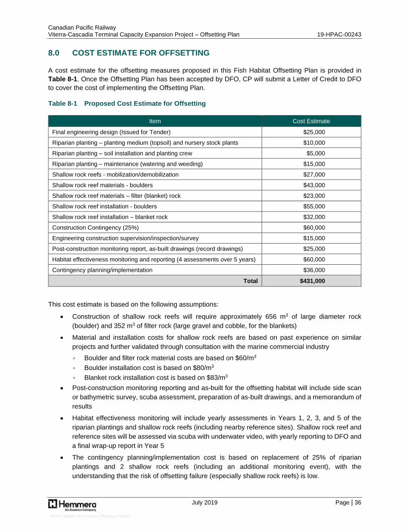
Canadian Pacific Railway Viterra-Cascadia Terminal Capacity Expansion Project – Offsetting Plan 19-HPAC-00243
July 2019 Page | 36
190724_updated_CP_Cascadia_Offsetting_Final.docx
8.0 COST ESTIMATE FOR OFFSETTING
A cost estimate for the offsetting measures proposed in this Fish Habitat Offsetting Plan is provided in Table 8-1. Once the Offsetting Plan has been accepted by DFO, CP will submit a Letter of Credit to DFO to cover the cost of implementing the Offsetting Plan.
Table 8-1 Proposed Cost Estimate for Offsetting
Item Cost Estimate
Final engineering design (Issued for Tender) $25,000
Riparian planting – planting medium (topsoil) and nursery stock plants $10,000
Riparian planting – soil installation and planting crew $5,000
Riparian planting – maintenance (watering and weeding) $15,000
Shallow rock reefs - mobilization/demobilization $27,000
Shallow rock reef materials - boulders $43,000
Shallow rock reef materials – filter (blanket) rock $23,000
Shallow rock reef installation - boulders $55,000
Shallow rock reef installation – blanket rock $32,000
Construction Contingency (25%) $60,000
Engineering construction supervision/inspection/survey $15,000
Post-construction monitoring report, as-built drawings (record drawings) $25,000
Habitat effectiveness monitoring and reporting (4 assessments over 5 years) $60,000
Contingency planning/implementation $36,000
Total $431,000
This cost estimate is based on the following assumptions:
Construction of shallow rock reefs will require approximately 656 m3 of large diameter rock (boulder) and 352 m3 of filter rock (large gravel and cobble, for the blankets)
Material and installation costs for shallow rock reefs are based on past experience on similar projects and further validated through consultation with the marine commercial industry ▫ Boulder and filter rock material costs are based on $60/m3 ▫ Boulder installation cost is based on $80/m3 ▫ Blanket rock installation cost is based on $83/m3
Post-construction monitoring reporting and as-built for the offsetting habitat will include side scan or bathymetric survey, scuba assessment, preparation of as-built drawings, and a memorandum of results
Habitat effectiveness monitoring will include yearly assessments in Years 1, 2, 3, and 5 of the riparian plantings and shallow rock reefs (including nearby reference sites). Shallow rock reef and reference sites will be assessed via scuba with underwater video, with yearly reporting to DFO and a final wrap-up report in Year 5
The contingency planning/implementation cost is based on replacement of 25% of riparian plantings and 2 shallow rock reefs (including an additional monitoring event), with the understanding that the risk of offsetting failure (especially shallow rock reefs) is low.
Canadian Pacific Railway Viterra-Cascadia Terminal Capacity Expansion Project – Offsetting Plan 19-HPAC-00243
July 2019 Page | 37
190724_updated_CP_Cascadia_Offsetting_Final.docx
9.0 TENURE
The area where offsetting will occur, including both riparian plantings and shallow rock reefs, is within lands administered by the VFPA (Figure 6). Offsetting overlaps with both an existing CP lease and additional adjacent areas that will be leased from VFPA. CP has advanced discussions with VFPA and they are supportive of the proposed Offsetting Plan. CP will ensure that required leases are amended and/or obtained prior to proposed construction of the offsetting.

Path: S:\Geomatics\Projects\103396\02\mxd\Fig6__103396_02_ProposedOffsettingHabitat_190724.mxd
P roduction Da te: Jul 24, 2019
P a ge Size: 11" x 17"
103396-02
N AD 1983 CSRS UTM Z one 10N
Burrard Inlet
N EW HHW LT
LLW MTMW LHHW MT
LLW LT
HHW LT
HHW LT
LLW LT
HHW MTMW L
LLW MTCASCADIA TERMIN AL
CP LEASE ROW
[P LAN V-4324(02)]
Viterra -Ca sca dia Term ina l Ca pa city Expa nsion P roject
Burra rd Inlet, Burna by, BC
Legend
±1:1,000
0 10 20 30 40 50Metres
Construction Z one Lim itP roposed Tra ck ExtensionSea wa rd Kelp Bed Extent (2019)Shorewa rd Kelp Bed Extent (2019)P roposed CP Lea se AreaExca va tion Area Beyond Gra ding StructureP roposed Ripra pP roposed Tra ck Rem ova lP roposed W a lkwa y for TurnoutRipa ria n Vegeta tionExisting CP Ra ilwa yP roposed Higher High W a ter La rge Tide (HHW LT)Tide Line
Artifical Reefs3m Buffer of CobbleRocky Reef Com plex
- Conta ins inform a tion licensed under the Open Governm ent Licences -P rovince of British Colum bia a nd City of Va ncouver- P roposed P roject Fea tures: AECOM, 2019- Aeria l Im a ge: City of Va ncouver, 2015
Sources
1. All m a pped fea tures a re a pproxim a te a nd should be used for discussionpurposes only.2. This m a p is not intended to be a “sta nd-a lone” docum ent, but a visua l a idof the inform a tion conta ined within the referenced Report. It is intended tobe used in conjunction with the scope of services a nd lim ita tions describedtherein.
N otes
Figure 6
Existing and Proposed Lease Areas
Canadian Pacific Railway Viterra-Cascadia Terminal Capacity Expansion Project – Offsetting Plan 19-HPAC-00243
July 2019 Page | 39
190724_updated_CP_Cascadia_Offsetting_Final.docx
10.0 CLOSURE
This work was performed in accordance with the Contract (Number 5600015425) between Hemmera, a wholly owned subsidiary of Ausenco, and Canadian Pacific Railway, dated December 1, 2018. This report has been prepared by Hemmera, based on fieldwork conducted by Hemmera, for sole benefit and use by Canadian Pacific Railway. In performing this work, Hemmera has relied in good faith on information provided by others and has assumed that the information provided by those individuals is both complete and accurate. This work was performed to current industry standard practice for similar environmental work, within the relevant jurisdiction and same locale. The findings presented herein should be considered within the context of the scope of work and project terms of reference; further, the findings are time sensitive and are considered valid only at the time the report was produced. The conclusions and recommendations contained in this report are based upon the applicable guidelines, regulations, and legislation existing at the time the report was produced; any changes in the regulatory regime may alter the conclusions and/or recommendations.
If you have any questions, please do not hesitate to contact the undersigned by phone at 604.669.0424.
Report prepared by: Report reviewed by: Hemmera Envirochem Inc. Hemmera Envirochem Inc.
Jim Roberts, B.Sc., R.P.Bio. Trevor Welton, B.Sc., R.P.Bio. Senior Fisheries Biologist Senior Fisheries Biologist; Business Lead
Canadian Pacific Railway Viterra-Cascadia Terminal Capacity Expansion Project – Offsetting Plan 19-HPAC-00243
July 2019 Page | 40
190724_updated_CP_Cascadia_Offsetting_Final.docx
11.0 REFERENCES
Bradford, M. J. 2017. Accounting for Uncertainty and Time Lags in Equivalency Calculations for Offsetting in Aquatic Resources Management Programs. Environmental Management 60:588–597.
Bustamante, R. H., G. M. Branch, and S. Eekhout. 1995. Maintenance of an exceptional intertidal grazer biomass in South Africa: subsidy by subtidal kelps. Ecology 76:2314–2329.
CCME. 2014. Canadian Water Quality Guidelines for the Protection of Aquatic Life. <http://st-ts.ccme.ca/en/index.html>. Accessed 15 Sep 2014.
Coastal Ocean Research Institute. 2017. Oceanwatch: Howe Sound Edition. Marine Science Centre-Vancouver Aquarium. Web 364 pp.
DFO. 2012. Southern Pacific Salmon Integrated Fisheries Management Plan Summary. Fisheries and Oceans Canada.
DFO. 2013a. Fisheries Protection Policy Statement. Fisheries and Oceans Canada, Ottawa, ON. <http://www.dfo-mpo.gc.ca/pnw-ppe/pol/PolicyStatement-EnoncePolitique-eng.pdf>.
DFO. 2013b. Measures to Avoid Causing Harm to Fish and Fish Habitat. Fisheries and Oceans Canada (DFO). <http://www.dfo-mpo.gc.ca/pnw-ppe/measures-mesures/index-eng.html>.
DFO. 2013c. Fisheries Productivity Investment Policy: A Proponent’s Guide to Offsetting. Fisheries and Oceans Canada (DFO), Ottawa, ON.
DFO. 2019. Area 28 (Bowen Island, Squamish, Vancouver, Indian Arm). < http://www.pac.dfo-mpo.gc.ca/fm-gp/maps-cartes/areas-secteurs/28-eng.html.
Gaylord, B., J. H. Rosman, D. C. Reed, J. R. Koseff, J. Fram, S. MacIntyre, K. Arkema, C. McDonald, M. A. Brzezinski, J. L. Largier, S. G. Monismith, P. T. Raimondi, and B. Mardian. 2007. Spatial patterns of flow and their modification within and around a giant kelp forest. Limnology and Oceanography 52:1838–1852.
GL Williams and Associates Ltd. 2005. Habitat Compensation Banking for Finfish Aquaculture. Prepared for Habitat Enhancement Branch, Department of Fisheries and Oceans (DFO). <http://www.dfo-mpo.gc.ca/Library/331814.pdf>.
Haegele, C. W., and Schweigert, J. F. 1985. Distribution and characteristics of herring spawning grounds and description of spawning mapping. Canadian Journal of Fisheries and Aquatic Sciences, 42: 39–5.
Hart, J.L. 1973. Pacific Fishes of Canada. Edited by Steveson, J.C., Watson, J., and Reinhart, J.M. Fisheries Research Board of Canada Bulletin 180. Ottawa, Ontario. 740p.
Hemmera Envirochem Inc. 2019a. Viterra-Cascadia Terminal Capacity Expansion Project - Marine Fish and Fish Habitat Assessment. Prepared for Canadian Pacific Railway.
Hemmera Envirochem Inc. 2019b. Viterra-Cascadia Terminal Capacity Expansion Project - Construction Environmental Management Plan. Prepared for Canadian Pacific Railway.
Canadian Pacific Railway Viterra-Cascadia Terminal Capacity Expansion Project – Offsetting Plan 19-HPAC-00243
July 2019 Page | 41
190724_updated_CP_Cascadia_Offsetting_Final.docx
Hourston, A. S., and C.W. Haegele. 1980. Herring on Canada's Pacific Coast. Can. Spec. Publ. Fish. Aquat. Sci. 48: 23p.
Keeling, B., M. Hessing-Lewis, C. Housty, D.K. Okamoto, E.J. Gregr, and A.K. Salomon. 2017. Factors driving spatial variation in egg survival of an ecologically and culturally important forage fish. Aquatic Conserv: Mar Freshw Ecocyst. 2017:1-14.
Kerr Wood Leidal Associated Ltd. (KWL). 2017. Burrard Inlet Action Plan. A science-based First Nations-led initiative to improve the health of the Burrard Inlet ecosystem by 2025. Prepared for the Tsleil-Waututh Nation.
MOE. 2002. BC Guidelines for Industry Emergency Response Plans. Guideline. <http://www.env.gov.bc.ca/eemp/resources/guidelines/bc.htm>.
MOE. 2017. British Columbia Approved Water Quality Guidelines: Aquatic Life, Wildlife & Agriculture. Summary Report. Prepared by the BC Ministry of Environment (MOE). Water Protection & Sustainability Branch. <http://www2.gov.bc.ca/assets/gov/environment/air-land-water/water/waterquality/wqgs-wqos/approved-wqgs/final_approved_wqg_summary_march_2016.pdf.>. Accessed 15 Oct 2017.
MWLAP. 2002. A Field Guide to Fuel Handling, Transportation and Storage. 3rd Edition, BC Ministry of Water, Land and Air Protection and BC Ministry of Forests. <http://www.env.gov.bc.ca/epd/industrial/oil_gas/pdf/fuel_handle_guide.pdf>.
Norderhaug, K. M., and H. Christie. 2011. Secondary production in a Laminaria hyperborea kelp forest and variation according to wave exposure. Estuarine, Coastal and Shelf Science 95:135–144.
Palsson, M. A. 1984. Egg mortality upon natural and artificial substrata within Washington State spawning grounds of Pacific herring (Clupea harengus pallassi). M. S. thesis, University of Washington, Seattle.
Reisewitz, S. E., J. A. Estes, and C. A. Simenstad. 2006. Indirect food web interactions sea otters and kelp forest fishes in the Aleutian archipelago. Oecologia 146:623–631.
Santelices, B., and F. P. Ojeda. 1984. Effects of canopy removal on the understory algal community structure of coastal forests of Macrocystis pyrifera from southern South America. Marine Ecology Progress Series 14:165–173.
Stantec Consulting Ltd. 2013. Fish Habitat Compensation Plan: Fairview terminal phase II Expansion Project. Burnaby, B.C.
Steneck, R. S., M. H. Graham, B. J. Bourque, D. Corbett, J. M. Erlandson, J. A. Estes, and M. J. Tegner. 2002. Kelp forest ecosystems: biodiversity, stability, resilience and future. Environmental Conservation 29:436–459.
Vance, R. R. 1988. Ecological Succession and the Climax Community on a Marine Subtidal Rock Wall. Marine Ecology Progress Series 48:125–136.